Abstract
Earth observation provides timely and spatially explicit information about crop phenology and vegetation dynamics that can support decision making and sustainable agricultural land management. Vegetation spectral indices calculated from optical multispectral satellite sensors have been largely used to monitor vegetation status. In addition, techniques to retrieve biophysical parameters from satellite acquisitions, such as the Leaf Area Index (LAI), have allowed to assimilate Earth observation time series in numerical modeling for the analysis of several land surface processes related to agroecosystem dynamics. More recently, biophysical processors used to estimate biophysical parameters from satellite acquisitions have been calibrated for retrieval from sensors with different high spatial resolution and spectral characteristics. Virtual constellations of satellite sensors allow the generation of denser LAI time series, contributing to improve vegetation phenology estimation accuracy and, consequently, enhancing agroecosystems monitoring capacity. This research study compares LAI estimates over croplands using different biophysical processors from Sentinel-2 MSI and Landsat-8 OLI satellite sensors. The results are used to demonstrate the capacity of virtual satellite constellation to strengthen LAI time series to derive important cropland use information over large areas.
1. Introduction
Earth observation that provides timely and spatially explicit information about land surface processes, such as vegetation dynamics, represents an advanced digital agriculture tool to derive important cropland use information over large areas, supporting decision making and sustainable agricultural land management. Biophysical parameters that have been largely used to monitor vegetation status, compared with the vegetation spectral indices calculated from optical multispectral satellite sensors, allow to quantitatively measure vegetation properties. The Leaf Area Index (LAI), a biophysical index defined as one half the total green (i.e., photosynthetically active) leaf area per unit horizontal ground surface area, can be estimated from the surface reflectance data acquired by satellite sensors. Vegetation biophysical characteristics, such as the canopy structure and photosynthetic capacity, are well described by LAI, which is largely used in agricultural studies [1].
LAI information is widely adopted for crop monitoring and for numerical modeling applications [2], to derive phenological metrics [3], and to identify and map the main crop types [4]. It has also been demonstrated to be effective to monitor vegetation dynamics [5] and to map terrestrial natural habitats [6].
A number of techniques, evolved in the past to derive the biophysical variables of vegetation using remote sensing data, can be grouped into four categories [7]: (i) parametric regression methods; (ii) non-parametric regression methods; (iii) physically based methods, using Radiative Transfer Models (RTMs); and (iv) hybrid retrieval methods, combining non-parametric and physically based approaches.
During the last decades, satellite optical multispectral sensors sensed the Earth’s surface either at medium spatial resolution and high revisit frequency or at high spatial resolution and low revisit frequency. Recently, the Copernicus Sentinel-2 satellite constellation, equipped with an MSI sensor, allows to sense the Earth’s surface at high spatial, spectral, and temporal resolutions, expanding the capacity for vegetation status and plant phenology monitoring from the time series of biophysical parameters.
The aim of this study is to compare the LAI estimates from the Sentinel-2 MSI and Landsat-8 OLI satellite data over croplands and other vegetation cover types in a selected test area, using the different biophysical processors available in the SNAP software, that belong to physically based estimation methods. Simple linear regression analysis is used to determine the linear relationship between different LAI estimates, coefficients, and error metrics.
2. Materials and Methods
2.1. Satellite Data
Sentinel-2 (S2) satellite images, acquired from September 2017 to December 2019 with cloud cover lower than 90%, were collected for granules ‘T32TPP’, whose spatial extent corresponds to the test site (Figure 1). The Multi-Spectral Instrument (MSI) sensor onboard S2 satellites is characterized by high spatial resolution (10 m, 20 m, and 60 m), high revisit capacity (5 days with a two-satellite constellation), and 13 spectral bands from the visible-to-shortwave infrared. Sentinel-2 MSI L2A data were collected from the Theia archive, representing the bottom of the atmosphere (BOA) reflectance, orthorectified, terrain-flattened, and atmospherically corrected with the MACCS-ATCOR Joint Algorithm (MAJA) [8].
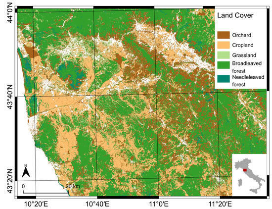
Figure 1.
Main vegetation cover in the study area (Italy).
After resampling all spectral bands to a 10 m resolution, pixels corresponding to clouds, cloud shadows, snow, and water in the product quality flag masks or corresponding to topographic shadows (identified by product quality flags representing the topographic mask and low-sun mask, with the latter considering the pixel aspect, slope, and sun zenith angle) were masked out from further analysis.
Landsat-8 (L8) satellites images, acquired from September 2017 to December 2019 with cloud cover lower than 90%, were collected for tiles ‘T192030′ and ‘T193029′, which overlay the S2 granule selected as a test site. The Operational Land Imager (OLI) sensor onboard L8 satellite is characterized by high spatial resolution (30 m), medium revisit capacity (16 days), and 9 spectral bands from the visible-to-shortwave infrared. Landsat-8 OLI Collection 2 data were collected from the USGS archive, representing the top of the atmosphere (L1TP) and bottom of the atmosphere (L2SR) reflectance, orthorectified, terrain-flattened, and atmospherically corrected. Pixels corresponding to clouds, cloud shadows, snow, shadows, and water in the product quality flag masks were masked out from further analysis. The bottom of atmosphere reflectances (L2SR), after being stacked with sun and view angles L1TP (using the SNAP processing graph available at https://github.com/ffilipponi/SNAP_L8_C2_BiophysicalLandsat8Op, accessed on 8 December 2021), were correct for changes in illumination due to terrain elevation [9].
2.2. Biophysical Parameters Estimation
Leaf Area Index (LAI) was estimated from surface reflectance data using the biophysical processors [10] available in SNAP software version 8, based on trained neural networks, recently updated to version 3.0 with newly calibrated coefficients. Apart from re-calibrated coefficients, the newly introduced features are the support for L8 OLI sensor, the optional use of S2 spectral bands at a 10 m spatial resolution only (specifically those at green (B3), red (B4), and near-infrared (B8) wavelengths), and the computation of the biophysical parameters by the use of the spectral response of each satellite sensor.
2.3. Comparison of LAI Estimates
Three sets of LAI estimates (S2; S2, using the 10 m processor; and L8) were stacked in large multidimensional datacubes, after applying an image co-registration step [11] to manage the weak spatial coherence of Sentinel-2 time series processed using processing baselines 01.xx and 02.xx [12]. Copernicus Land Monitoring Service datasets were used to generate a vegetation land cover map, used for subsequent analysis.
A linear regression model was created for each combination of unique pairs from the three LAI sets, using the entire datacubes as dependent and independent variables. A model was generated for both spatial and temporal dimensions, the latter without the use of an intercept value. Additionally, separate models were created for the following land cover classes: all vegetated pixels; croplands; grasslands; broadleaved forest; and needleleaved forest. Regression coefficients and the coefficient of determination (R2) were computed for each model, together with the root mean square error (RMSE).
In order to perform the comparison between S2 and L8 LAI estimates, S2 datacubes were resampled to fit a 30 m spatial resolution, using average resampling statistics, and only synchronous acquisitions were used.
All the procedures used to analyze the data were performed using GDAL libraries, R, GRASS GIS, and SNAP software.
3. Results and Discussions
Spatially explicit linear regression results are shown in Figure 2. Croplands resulted in a regression coefficient close to 1, while forested areas resulted in higher intercept values and a consequently lower regression coefficient. A high coefficient of determination values demonstrates the robustness of the linear regression model.
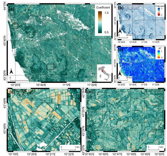
Figure 2.
Spatially explicit linear regression results: (a) linear regression coefficient; (b) linear regression intercept; (c) coefficient of determination; (d) spatial detail of linear regression coefficient over plain croplands; and (e) spatial detail of linear regression coefficient over hilly croplands.
The LAI biophysical processor calibrated on S2 spectral bands at 10 m spatial resolution overestimates the LAI values, compared with the biophysical processor calibrated on the S2 full spectrum and with the biophysical processor calibrated on the L8 (Figure 3). The LAI estimates from the biophysical processor calibrated on L8 have a strong linear relationship with the LAI estimates from the model calibrated on the S2 full spectrum. This evidence demonstrates how red-edge and short-wave infrared spectral reflectances provide key information related to vegetation status, which complements plant photosynthetic activity revealed from visible and near-infrared wavelengths.
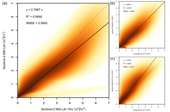
Figure 3.
Density scatterplot showing the linear relationship for LAI estimated from different spectral bands sets. (a) Sentinel-2 MSI 10 m spectral bands set against Sentinel-2 MSI full spectral bands set; (b) Landsat8 OLI spectral bands set against Sentinel-2 MSI full spectral bands set; (c) Landsat8 OLI spectral bands set against Sentinel-2 MSI 10 m spectral bands set.
The LAI biophysical processor calibrated on S2 spectral bands at the 10 m spatial resolution overestimates the LAI values for the different plant functional types (Figure 4). This overestimation was found to be higher for grasslands and lower for needleleaved forests. Further improvements require in situ measurements to complement the linear relationship analysis with the evaluation of accuracy metrics.
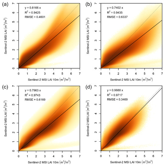
Figure 4.
Density scatterplot showing the linear relationship for LAI estimated using the two Sentinel-2 MSI models calibrated on different band sets for main land cover classes: (a) croplands; (b) grasslands; (c) broadleaved forests; and (d) needleleaved forests.
The plot in Figure 5 shows how LAI estimates from multiple satellite sensors, with an unbiased linear relationship, can constitute denser time series from virtual satellite constellation, contributing to improve temporal analysis, such as vegetation phenology estimation, and consequently enhancing agroecosystems monitoring capacity. The weak spatial coherence of Sentinel-2 acquisitions over time requires an image co-registration procedure to be applied in order to reduce shaky time series [12].
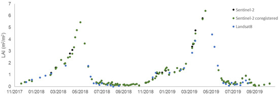
Figure 5.
LAI time series for a winter cereal pixel.
4. Conclusions
A comparison of LAI estimates from Sentinel-2 MSI and Landsat-8 OLI satellite data over croplands and other vegetation cover types, using different biophysical processor, was presented. The results from the linear regression analysis demonstrate a general underestimation of the LAI biophysical processor calibrated on S2 spectral bands at a 10 m spatial resolution, compared with the biophysical processor calibrated on the S2 and L8 full spectrum. The biophysical processor calibrated on the full spectrum provides stronger linear relationships between LAI estimated from S2 MSI and L8 OLI satellite sensors, encouraging the use of estimated biophysical parameters time series from virtual satellite constellation, to derive important cropland use information over large areas.
Supplementary Materials
The poster presentation is available online at https://www.mdpi.com/article/10.3390/IECAG2021-09683/s1.
Institutional Review Board Statement
Not applicable.
Informed Consent Statement
Not applicable.
Acknowledgments
This work contains modified Copernicus Sentinel data Copernicus Service information (2021). Landsat8 OLI image was obtained courtesy of the U.S. Geological Survey. The author is grateful to the many individuals working on the development of free and open-source software for supporting the sharing of knowledge.
Conflicts of Interest
The author declares no conflict of interest.
References
- De Peppo, M.; Dragoni, F.; Volpi, I.; Mantino, A.; Giannini, V.; Filipponi, F.; Tornato, A.; Valentini, E.; Nguyen Xuan, A.; Taramelli, A.; et al. Modelling the ground-LAI to satellite-NDVI (Sentinel-2) relationship considering variability sources due to crop type (Triticum durum L., Zea mays L., and Medicago sativa L.) and farm management. In Proceedings of the SPIE Remote Sensing for Agriculture, Ecosystems, and Hydrology XXI, Strasbourg, France, 9–12 September 2019; p. 111490I. [Google Scholar] [CrossRef]
- De Peppo, M.; Taramelli, A.; Boschetti, M.; Mantino, A.; Volpi, I.; Filipponi, F.; Tornato, A.; Valentini, E.; Ragaglini, G. Non-parametric statistical approaches for Leaf Area Index estimation from Sentinel-2 data: A multi crop assessment. Remote Sens. 2021, 13, 2841. [Google Scholar] [CrossRef]
- Filipponi, F.; Smiraglia, D.; Agrillo, E. Earth Observation for Phenological Metrics (EO4PM): Temporal discriminant to characterize forest ecosystems. Remote Sens. 2022. in preparation. [Google Scholar]
- Filipponi, F.; Smiraglia, D.; Mandrone, S.; Tornato, A. Cropland mapping using Earth Observation derived phenological metrics. Proceedings 2021, 68. accepted. [Google Scholar]
- Filipponi, F.; Manfron, G. Observing Post-Fire Vegetation Regeneration Dynamics Exploiting High-Resolution Sentinel-2 Data. Proceedings 2019, 18, 10. [Google Scholar] [CrossRef] [Green Version]
- Agrillo, E.; Filipponi, F.; Pezzarossa, A.; Casella, L.; Smiraglia, D.; Orasi, A.; Attorre, F.; Taramelli, A. Earth Observation and Biodiversity Big Data for Forest Habitat Types Classification and Mapping. Remote Sens. 2021, 13, 1231. [Google Scholar] [CrossRef]
- Verrelst, J.; Rivera, J.P.; Veroustraete, F.; Muñoz-Marí, J.; Clevers, J.G.P.W.; Camps-Valls, G.; Moreno, J. Experimental Sentinel-2 LAI estimation using parametric, non-parametric and physical retrieval methods—A comparison. ISPRS J. Photogramm. Remote Sens. 2015, 108, 260–272. [Google Scholar] [CrossRef]
- Hagolle, O.; Huc, M.; Desjardins, C.; Auer, S.; Richter, R. MAJA Algorithm Theoretical Basis Document; CNES-DLR: Berlin, Germany, 2017. [Google Scholar] [CrossRef]
- Meyer, P.; Itten, K.I.; Kellenbenberger, T.; Sandmeier, S.; Sandmeier, R. Radiometric corrections of topographically induced effects on Landsat TM data in an alpine environment. ISPRS J. Photogramm. Remote Sens. 1993, 48, 17–28. [Google Scholar] [CrossRef]
- Weiss, M.; Baret, F. S2 ToolBox Level 2 Products: LAI, FAPAR, FCOVER. 2016. Available online: https://step.esa.int/docs/extra/ATBD_S2ToolBox_L2B_V1.1.pdf (accessed on 31 March 2021).
- Scheffler, D.; Hollstein, A.; Diedrich, H.; Segl, K.; Hostert, P. AROSICS: An Automated and Robust Open-Source Image Co-Registration Software for Multi-Sensor Satellite Data. Remote Sens. 2017, 9, 676. [Google Scholar] [CrossRef] [Green Version]
- Filipponi, F. Exploitation of Sentinel-2 Time Series to Map Burned Areas at the National Level: A Case Study on the 2017 Italy Wildfires. Remote Sens. 2019, 11, 622. [Google Scholar] [CrossRef] [Green Version]
Publisher’s Note: MDPI stays neutral with regard to jurisdictional claims in published maps and institutional affiliations. |
© 2021 by the author. Licensee MDPI, Basel, Switzerland. This article is an open access article distributed under the terms and conditions of the Creative Commons Attribution (CC BY) license (https://creativecommons.org/licenses/by/4.0/).