Article

Post-Fire Restoration of the Vegetation at the Cemetery of the Tatoi Estate Historical Site

Doxiadis+, 6 Apollonos Street, 10557 Athens, Greece
*
Author to whom correspondence should be addressed.
Architecture 2025, 5(1), 7; https://doi.org/10.3390/architecture5010007
Submission received: 30 July 2024 / Revised: 25 October 2024 / Accepted: 31 December 2024 / Published: 21 January 2025

Abstract

:
The restoration of historical landscapes is crucial for preserving the cultural heritage. This study focuses on the cemetery of the former royal Tatoi estate, a historical site severely damaged by a wildfire in 2021. The fire almost completely eradicated the vegetation on Palaeokastro hill, necessitating a comprehensive vegetation restoration strategy. This research aims to restore the natural environment and historical landscape landmarks and improve future fire protection conditions. This study emphasizes creating a firebreak zone through thinning vegetation, aiding natural regeneration, and planting new seedlings, particularly Aleppo pines and cypresses. We recommend thinning interventions to reduce tree density, which improves the health of the remaining trees and lowers the fire risk. Additionally, the restoration of historical pathways, including cypress-lined routes, is proposed to preserve the cultural landscape. This study underscores the importance of maintaining the historical integrity and enhancing the resilience of the landscape against future fires.

1. Introduction

Restoring a forest after a fire involves a significant decision regarding choosing between natural regeneration or planting or seeding new seedlings. Active restoration has drawbacks, such as the high cost of planting young seedlings, which may have a high mortality rate, up to 50%, while seeding has a low success rate. Therefore, this method is recommended only in cases where natural regeneration is not observed. In contrast, natural regeneration has advantages, such as higher seedling survival rates and faster growth rates, as regenerating seedlings already have an established root system. Therefore, assisted natural regeneration, which may include managing the regenerating forest through thinning or removing unwanted vegetation, is recommended [1].
Aleppo pine forests are adapted to the dry conditions that favor fire incidents in the Mediterranean basin and are characterized by their ability to regenerate through the seed bank retained in the cones of adult trees. The most critical parameter for ensuring regeneration is the forest’s maturity before the fire [2]. Thus, natural regeneration is strongly related to the quantity and quality of seeds remaining in the cones of adult trees before the fire. Aleppo pine forests have a short juvenile period, which can be three to six years for some individuals and 12–20 years for the entire population [3].
Many researchers have recorded a high number of young seedlings in regenerating pine forests after fire incidents. Tsitsoni [4] recorded 0.6–14.26 Aleppo pine seedlings per m2 in regenerating forests in Kassandra, Halkidiki Greece, one to eight years after a fire, while Zagas [5] reported 8.7–18.5 Aleppo pine seedlings per m2 in regenerating forests in Attica Greece, two years after a fire. Moya et al. [6] reported Aleppo pine seedling densities ranging from one to six per m2 in regenerating forests in Spain. Seedling survival rates decrease due to competition conditions during the years following a fire, with survival rates of approximately 30–50% reported 5–6 years after a fire [2].
Often, the density of new seedlings after a fire in pine forests is very high, creating intense competition conditions that lead to low growth rates and the accumulation of high fuel loads. Thinning interventions are sometimes necessary [2]. Thinning improves the quality of young seedlings and accelerates their growth rate [7].
In cases where natural regeneration is not observed or deemed inadequate, seeding or planting new seedlings may be carried out. Zagas et al. [8] found that the germination rate of Aleppo pine seeds was below 3% when seeded in a burned forest in Sithonia, Halkidiki Greece. However, many researchers argue that establishing Aleppo pine seedlings is not difficult. Zagas et al. [8] found a successful establishment rate of approximately 95% for seedlings transplanted with paper containers, while bare-root seedlings had a success rate of about 80%. The planting density can be 25 seedlings per 100 m2 and at least 3 seedlings per 100 m2 [8].
The main factors contributing to the occurrence and development of a fire include meteorological conditions, topography, vegetation formation, and social and economic factors [9,10,11]. In fuel models, the studied parameters include vegetation type (evergreen sclerophyllous shrubs, phrygana, grasslands with herbs, forests with leaf litter, etc.), foliage quantity, dead plant residue mass and thickness on the ground, average vegetation height, relative coverage by shrubs and grasses, fuel load depending on plant stem diameter, etc. [12]. Note that in fuel models, the studied parameters concern ground fuel characteristics, not tree canopy characteristics, as crown fires are caused by surface fire heat transfer. In surface fires, the fuel consists of dead matter on the ground, herbs, and shrubs.
A crown fire is defined as one that spreads to the tree canopies, burning aerial fuel at heights greater than 3 m [13]. Crown fires have a high thermal intensity and spreading speed, are difficult to control, have destructive impacts compared to surface fires, and are responsible for the majority of burned areas in conifer forests [14,15,16,17,18]. Factors affecting the initiation and speed of crown fires include surface fire thermal intensity, aerial fuel initiation height, vertical fuel continuity, available surface and aerial fuel, wind speed, and the moisture content of surface and aerial fuel foliage [13].
The significance of the distance between aerial fuel (tree crown base) and surface fuel (understory fuel) is crucial for crown fire initiation. A small distance between aerial and surface fuel and a high surface fuel load are factors that often contribute to crown fire initiation. Conversely, increasing the distance between the tree canopy and the understory requires higher heat flows from the surface fuel to ignite the canopy [13]. In Aleppo pine forests, the aerial fuel initiation height ranges from 3 to 6.5 m, considered relatively low, given that the understory height from evergreen broadleaved species often reaches 3 m. Under such conditions, crown fire transmission is inevitable. Additionally, the intense presence of climbing plants in Aleppo pine clusters, such as Smilax aspera L., certainly contributes to flame transmission to the canopy [13].
The amount of surface fuel consumed in a surface fire strongly affects the thermal flow reaching the base of aerial fuel [19]. Higher heat flows and greater thermal intensity in the understory create crown fires and lead to higher transmission speeds [13].
Since meteorological conditions affecting foliage moisture content cannot be modified, measures to prevent crown fires focus on modifiable factors, specifically the management of surface and aerial fuel. These usually include reducing surface fuel, thinning forest stands to reduce horizontal fuel continuity, and removing logging residues [20,21,22,23,24,25].
Due to the involvement of both fuel layers in a crown fire, a combination of aerial and surface fuel management is necessary. Combining stand thinning with surface fuel reduction is considered an effective measure to prevent and reduce the severity of crown fires in Aleppo pine forests. Applying this measure has been observed to keep the fire at the surface level under typical fuel moisture conditions. Combining these actions must always be followed by removing thinning residues [13].
Preventing the formation of an understory of shrubby species is crucial for preventing fire transmission in an area. Proper management includes clearing paths and high pruning [26], while Aleppo pine stands with an understory of dry pine needles have a lower probability of crown fire initiation [13].
These measures should be repeated periodically, as discontinuing management measures is expected to lead to fuel accumulation and increase the potential for future high-intensity and destructive crown fires [13].
These practices are detailed in the study “Post-Fire Vegetation Management in the Fire-Affected Area of 2018 of Nea Makri and Rafina Municipal Units, Guidelines” [27]. The study develops the methodology for creating firebreak zones (fuel breaks). Fuel breaks are areas where fuel continuity is managed to reduce fire intensity and limit its spread. These practices include the following:
  • Minimum distance between tree crowns: 4 m;
  • Maximum horizontal coverage of tree stands: 15 m;
  • Minimum distance between tree stands equal to the diameter of the largest stand;
  • Maximum horizontal coverage of shrub stands: 5 m;
  • Minimum distance between shrubs equal to the diameter of the largest shrub or stand and at least 2 m;
  • Minimum distance between buildings and tree or shrub crowns: 5 m;
  • Ground cover with phrygana can be continuous;
  • Shrubs may exist under trees, but there must be a vertical break in crown continuity. The gap between the tree crown base and the shrub top must be three times the shrub height;
  • Pruning tree branches up to a height of 2.5 m.
Fires, the most significant disturbance for vegetation in Mediterranean ecosystems, show an increasing trend in these ecosystems due to climate change [9,10,11,28,29]. It has been estimated that the interval between fires in a Mediterranean ecosystem could decrease from 72 years in broad-leaved shrublands (strawberry trees, Arbutus unedo L.), according to current climatic data, to 62–64 years under increased hot and dry days due to climate change scenarios. A similar reduction was observed in phrygana shrublands, from 20 to 16–17 years [11].
In Greece, it is predicted that in the near future (2021–2050), the critical days for fire occurrence will increase by 15–20 days annually in Western and Northern Greece and by 10 days in Eastern and Southern Greece. In the distant future (2071–2100), critical days for fire occurrence will increase by 30–40 days in Western and Northern Greece and by 20–30 days in Eastern and Southern Greece [9]. Aleppo pine forests in Greece, with their rich undergrowth, are particularly flammable [13,30,31], and the problem of forest fires is significant and continuously worsening in Mediterranean countries. In Greece, fires are the main factor in forest degradation [13].
In August 2021, a wildfire broke out at the Tatoi estate historical site, causing significant damage to the vegetation and landscape of the estate cemetery, generating the need to develop a vegetation restoration study. Historical sites, as defined by Greek law and further recognized in global heritage frameworks, are essential for their role in anchoring the collective cultural memory and fostering a connection between past and present generations. Sites such as the Tatoi estate exemplify this heritage through their physical monuments and landscapes, which serve as reminders of historical events and evolving social identities. Furthermore, international frameworks, including those by UNESCO and ICOMOS, advocate for preserving both tangible and intangible elements.
The Greek national law “For the protection of antiquities and cultural heritage” [32] aims to “preserve historical memory for the present and future generations”. Historical sites are areas where significant historical events took place or areas containing monuments or complex works of man and nature forming characteristic and homogeneous spaces, geographically definable and requiring protection due to their folklore, ethnological, or social, technical, architectural, industrial, historical, artistic, or scientific significance.
In addition to national legislation for historical sites, international organizations like ICOMOS focus on protecting the broader concept of cultural landscapes. Cultural landscapes are a synthesis of nature and humanity, reflecting the ongoing and close relationship between the two. They express social evolution influenced by the constraints and opportunities offered by the natural environment and successive social, economic, and cultural influences [33]. Furthermore, the Quebec Declaration [34] aims to protect the spirit of place (genius loci), including tangible (buildings, places, landscapes, routes, objects) and intangible elements (memories, descriptions, writings, celebrations, traditions, values, textures, colors, and smells) that give meaning, value, emotion, and mystery to a place.
Cultural landscapes significantly contribute to preserving and highlighting cultural heritage, sustainable environmental management, and sustainable tourism development. Highlighting compositions of nature and humanity can add value to a new, broader, innovative, and sustainable framework for cultural tourism development.
Despite significant advancements in post-fire restoration techniques, research remains limited in addressing the dual challenges of ecological restoration and cultural heritage preservation in historically significant sites. Most studies tend to focus on either ecological resilience—such as enhancing fire resistance in native vegetation—or cultural preservation independently, without adequately integrating these objectives. This gap is particularly relevant in Mediterranean countries like Greece, where a high risk of wildfires intersects with dense historical landscapes rich in cultural heritage. This study aims to bridge this gap by providing a model that addresses both ecological restoration needs, such as promoting natural regeneration and reducing fire risk, and the preservation of cultural landscapes.
The primary research goals of this study are to explore how post-fire restoration can be optimized for historically significant sites, to identify methods that balance vegetation management with heritage conservation, and to assess the broader implications of this integrated approach for sustainable heritage management. Through a focus on the cemetery of the Tatoi estate, this research not only proposes a management plan but also contributes to developing integrated restoration practices that may be applied to similar cultural heritage sites facing ecological threats worldwide.
Given that the cemetery of the Tatoi estate forms a key part of this designated historical site, where natural and cultural elements merge to reflect the historic and aesthetic identity of the Attic landscape, this study’s objectives for restoring the cemetery and surrounding vegetation following the destructive August 2021 fire include the following:
  • Restoring the natural environment through the re-establishment of vegetation, particularly the Aleppo pine and cypress species;
  • Revitalizing historical landmarks, such as the cemetery’s cypress-lined pathways;
  • Enhancing fire resilience through strategic vegetation management;
  • Restoring the original historical pathways.

2. Materials and Methods
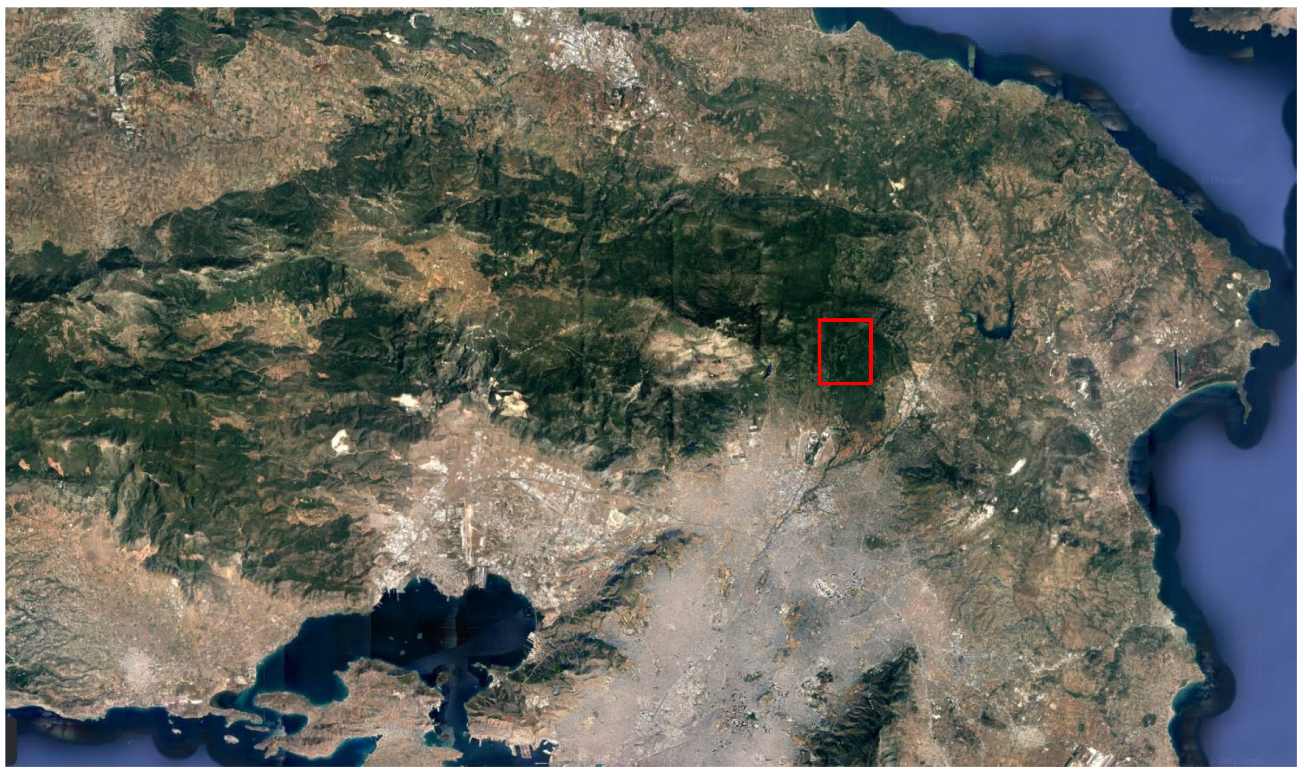
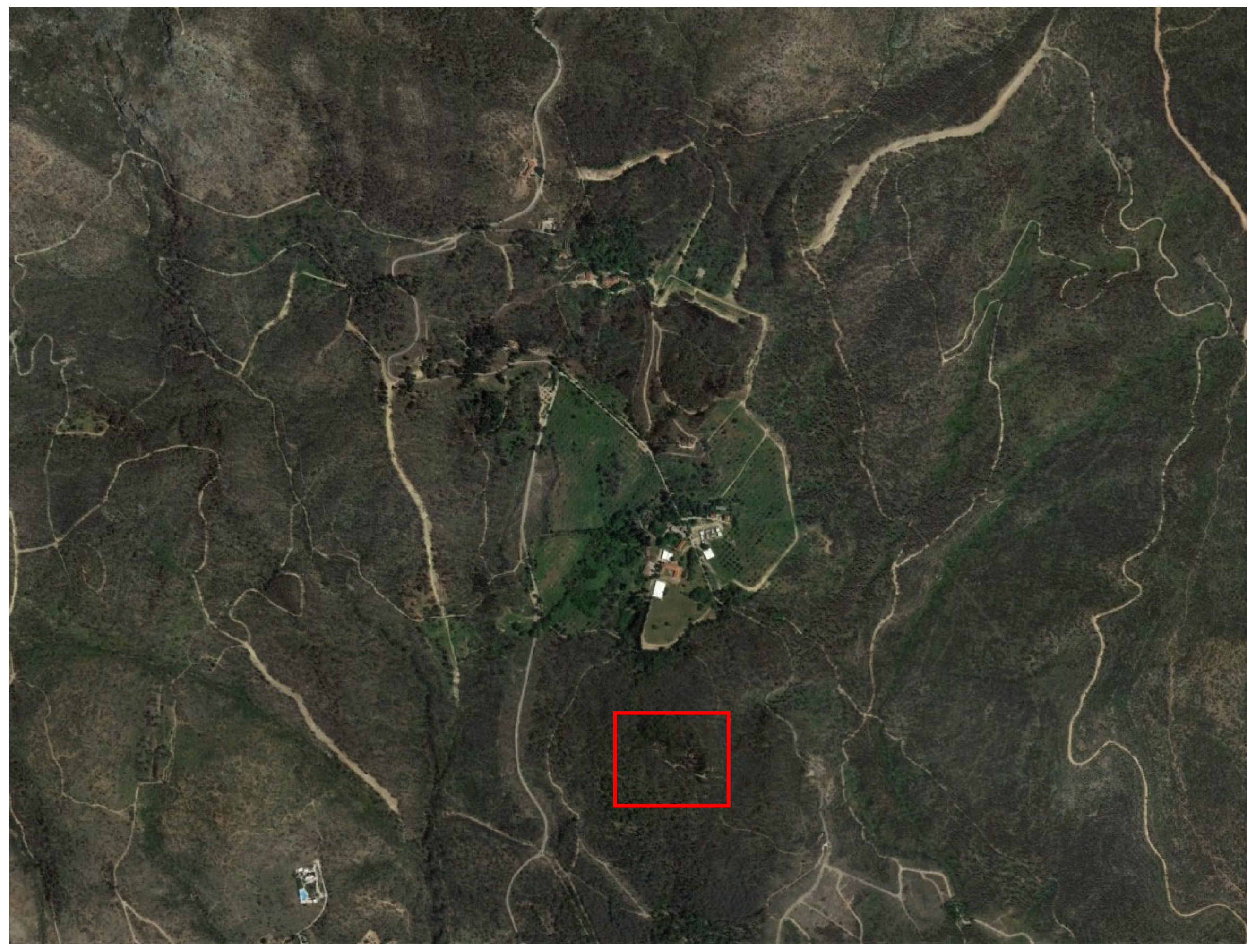
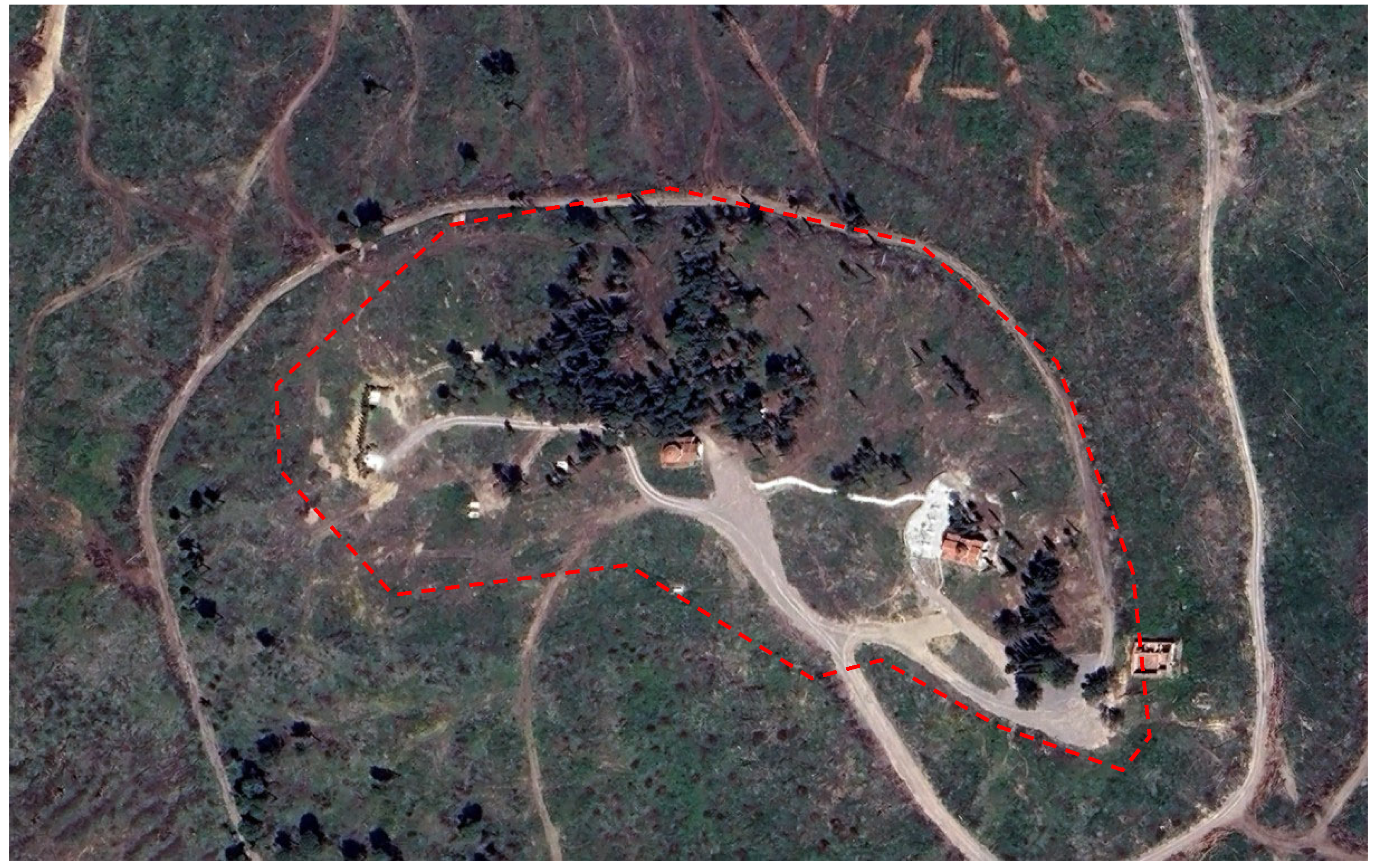
2.1. Study Area

The Tatoi estate historical site is located on the eastern foothills of Mount Parnitha in Attica (central Greece), approximately 20 km north of central Athens (38°09′ N, 23°47′ E, 500 m a.s.l.) (Figure 1). The study area concerns the estate’s cemetery, covering about 30 acres on the hill of Palaeokastro, at an elevation of 40 m relative to the surrounding area (Figure 2).
According to maps of Mavromatis [37,38], the character of the bioclimate of the Tatoi area is intensely Mediterranean, with the vegetation classified as of Mediterranean Quercion ilicis formation, of the Balkan and Eastern Mediterranean type, while Karetsos et al. [26] stated that the Tatoi estate area is classified under the Quercion ilicis and Andrachno-Quercetum ilicis unions.
In this zone, the Aleppo pine (Pinus halepensis Mill.) finds its optimal development in Greece. Aleppo pine forests in Greece are typically multi-layered, with a rich undergrowth of evergreen broadleaves such as kermes oak, mastic trees, heather, rockrose, etc. [8]. Indeed, natural pine forest is the main type of high forest in the Tatoi area, mixed with cypress (Cupressus sempervirens L.), while the undergrowth consists of evergreen broadleaved shrubs such as strawberry trees (Arbutus unedo L.), wild olive (Olea europaea L.), kermes oak (Quercus coccifera L.), mastic (Pistacia lentiscus L.), etc. [26].
Parnitha, with its significant size, rich flora, diverse terrain, and high level of protection as a National Park, Wildlife Refuge, Special Protection Area (SPA) for birdlife, and a Natura 2000 Network site, provides excellent conditions for the development of wildlife. The fauna of the area includes 39 species of mammals, such as deer (Cervus elaphus L.), wolves (Canis lupus L.), and other smaller mammals, such as hedgehogs (Erinaceus concolor Martin), 158 species of birds, various reptiles, and amphibians [39].
Climatic data concerning the study area are presented in Table 1.

2.2. Historical Background

The Tatoi estate was the summer palace of the former Greek royal family and includes various buildings, such as the main palace, outbuildings, stables, staff quarters, and a cemetery where members of the Greek royal family are buried. It is designated as a historical site due to its association with significant historical events and its historical and aesthetic significance in the Greek Attic landscape, forming a characteristic core of environmental, natural, cultural, and architectural elements [40].
The Tatoi estate has a rich history. However, this study concentrates on Palaeokastro hill, where the cemetery is located. The history of Palaeokastro hill dates back to ancient times. The hill served as a fortification site for the Lacedaemonians from the last phase of the Peloponnesian War, [41] (Stamatopoulos, 2004, A p. 58), depicted on Kaupert’s maps of Attica with the note “fortified camp” [42].
In more recent history, Palaeokastro hill became part of the estate, subsequently named Tatoi, which was transferred to King George I in May 1872 [41]. Initially selected in 1880 for the burial of Princess Olga [38], this site gradually evolved into a cemetery. In 1899, the Cemetery Church of the Resurrection of the Savior was built on Palaeokastro [41]. Over the following years, 18 more graves for other royal family members were established: King George I (1913), Queen Olga (1936), Prince Nicholas (1938), Prince Christopher (1940), Princess Alexandra (1940), Princess Maria (1940), Prince Andrew (1946), King George II (1947), Princess Françoise (1953), Princess Helen (wife of Prince Nicholas) (1957), Maria Bonaparte (1962), King Paul (1964), Queen Frederica (1981), Queen Alexandra of Yugoslavia (1993), Princess Aspasia (1993), Princess Catherine (2007), and King Constantine II (2023). Additionally, a mausoleum was built, which holds the remains of Kings Constantine I, Sophia, and Alexander I (1936) [41].
The Cemetery Church of the Resurrection, designed by Anastasios Metaxas, is single-story, cross-shaped, with a central dome and load-bearing stone walls and a wooden roof. The mausoleum is a Neo-Byzantine single-story structure, square-shaped with a central dome. Both the church and the mausoleum buildings are well-preserved. Around the church and mausoleum, the 19 graves of the Greek royal family members interred at Palaeokastro cemetery are also preserved in excellent conditions. The tombs are mostly simple and made of Pentelic marble, with the exception of the tombs of Prince Nicholas and his wife, which are more ornate [41].

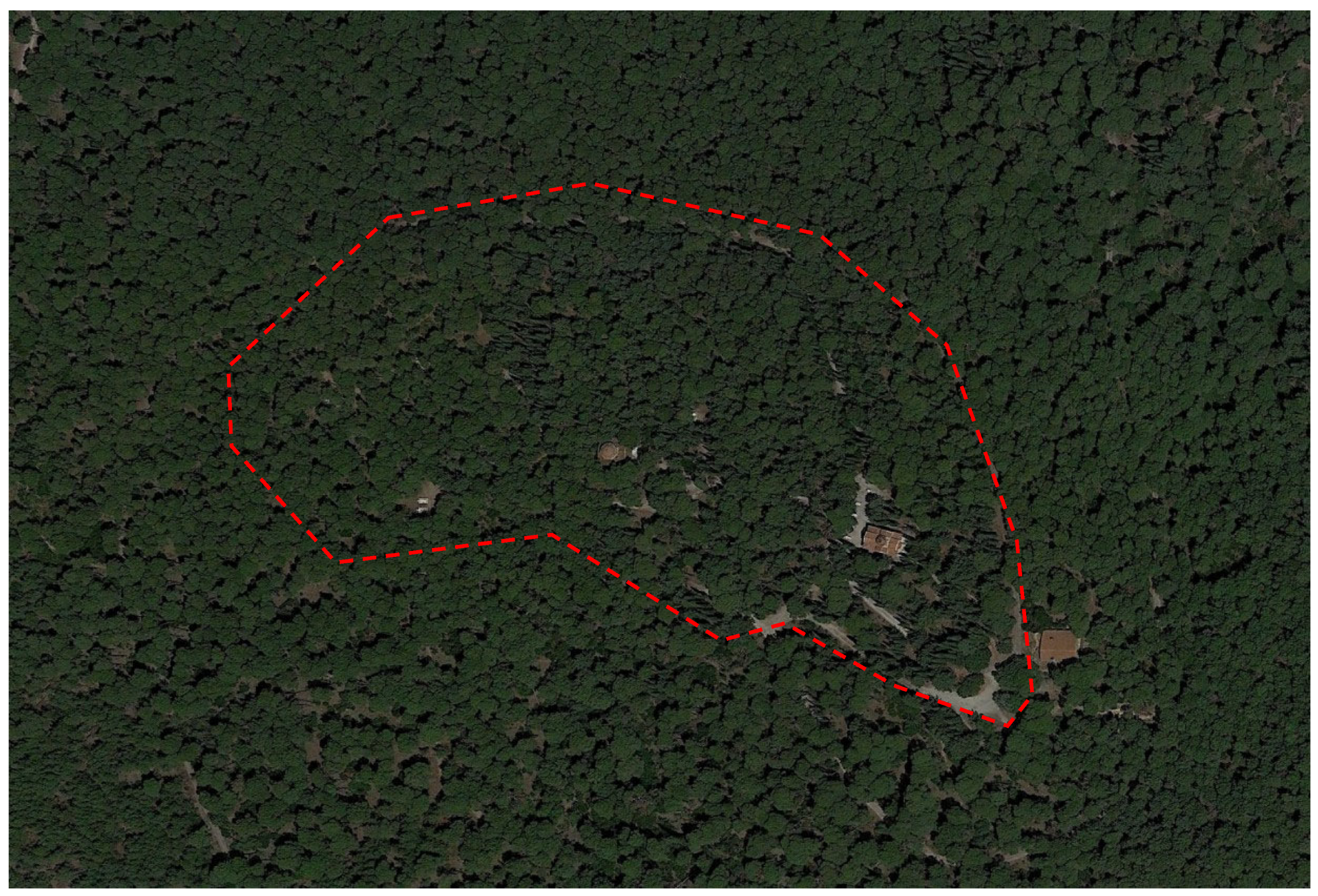
2.3. Cemetery Vegetation and Paths

During its history, Palaeokastro hill’s vegetation was similar to the rest of the estate, dominated by Aleppo pines and cypresses, as shown in archival photographs (1920s–1970s) and a 1950 vegetation map [42]. Specifically, the vegetation map indicates that Aleppo pines and cypresses lined the path to Palaeokastro and the eastern side of the hill around the Resurrection Church, while the western side had only Aleppo pines [41]. Linear cypress plantings are visible along various paths in archival photographs, and the paths were covered in gravel.
In more recent years, photos of the site from 2010 show the hill covered with a dense layer of Aleppo pines and cypresses. The same observation can be made from satellite images before the fire (Figure 3). The hill’s vegetation in recent years before the 2021 fire seems unchanged compared to the archival photos and the same as throughout its 100 year old history. Additionally, photos from 2010 show dense understory development. According to the literature, these species likely included strawberry trees, mastic, kermes oak, rockrose, etc. [26].
The August 2021 fire almost completely eradicated the vegetation on Palaeokastro hill. Only a small patch of the vegetation that existed before the fire was preserved on the hill, extending north of the mausoleum, covering an area of approximately 4.5 acres out of the 30 acres in total (Figure 4). There are also a few other trees and smaller patches of vegetation scattered around. The patches of vegetation that survived the fire consisted of cypress trees (Cupressus sempervirens L.) and Aleppo pine trees (Pinus halepensis Mill.). Additionally, very young seedlings of olive trees (Olea europaea L.) and Judas trees (Cercis siliquastrum L.) were recorded. Furthermore, shrub species were documented, including rockroses (Cistus creticus L. and Cistus salvifolius L.), kermes oaks (Quercus coccifera L.), laurestines (Viburnum tinus L.), mastic trees (Pistacia lentiscus L.), and strawberry trees (Arbutus sp.).
In the rest of the hill area where the vegetation had burned, the clearing and removal of the burnt trunks had been carried out. However, logging debris, such as branches and smaller twigs, remained scattered throughout the area.
In the rest of the hill area, where the terrain had not been disturbed by recent landscaping interventions (2023), young Aleppo pine seedlings were growing.
Finally, in areas where the canopy was burned, the lack of shading had led to the growth of annual herbaceous species (therophytes), both winter–spring and summer–autumn species.
The cemetery area, apart from the graves, church, and mausoleum, retains elements of historical pathways in various states of preservation, as well as traces of linear cypress plantings (Figure 5). Some paths are in relatively good condition, bordered by semi-carved stones and paved with rounded gravel with a maximum diameter of approximately 10 cm. Others show remnants of linear cypress plantings, with the bases of the trunks still present, allowing for measurements of the distances between them. Finally, some paths are in poor to fair condition, marked by scattered stones or significantly disturbed by recent activities, leaving only minimal remnants visible.

2.4. Measurements

To measure the indicative tree density and relative proportion of two tree species in the 4.5-acre vegetation patch that survived the 2021 fire, we followed a systematic sampling approach. First, we randomly selected three quadrats within the vegetation patch, each measuring 7 × 7 m (49 m2). In each quadrat, we measured the number of trees by species and calculated the average tree density across the quadrats to determine the indicative density and species proportion within the patch. A similar method was implemented in order to measure the density of young regenerating Aleppo pine seedlings. We used smaller 1 × 1 m quadrats and conducted measurements in 15 randomly placed quadrats, counting the number of Aleppo pine seedlings in each and calculating the average seedling density across the quadrats.

3. Results

Given that the cemetery of the Tatoi estate is part of a designated historical site where natural and cultural wealth combine to form a synthesis connected to the historicity and aesthetics of the Attic landscape, this study’s goals for restoring vegetation and enhancing the historical landscape after the devastating fire of August 2021 were as follows:
  • Restoring the natural environment: This involves re-establishing the vegetation formation and plant species, particularly the Aleppo pine and cypress tree layer;
  • Restoring historical landscape landmarks: Specifically, the cypress-lined pathways within the cemetery;
  • Improving fire protection conditions through vegetation fragmentation;
  • Restoring the historical paths.

3.1. Vegetation Restoration

The results of the measurements showed that the tree density in the surviving vegetation patch was high and had led to intense competition and the degradation of the health and quality of the crowns of the existing trees. The indicative average density was approximately 16.33 ± 1.45 trees per 50 m2, or about 33 trees per 100 m2, corresponding to planting distances of about 1.7 m, which was confirmed by on-site measurements. The relative proportion of species was approximately 1:9, Aleppo pines to cypresses. However, this ratio is not considered indicative for the entire hill, as the surviving vegetation patch and sample quadrats were taken from an area of the hill where there was a higher density of cypresses.
In the rest of the hill area, where the terrain had not been disturbed by recent landscaping interventions, the results of the measurements showed that the average density of the young Aleppo pine seedlings was 18.33 ± 4.11 per m2.
To protect and enhance the historical identity of the area, we propose that the new vegetation formation in the cemetery incorporate the characteristics of a firebreak zone (fuel break) (Figure 6) [27]. More specifically, we recommend that the new vegetation structure meet the following criteria:
  • Maintain a minimum distance between tree crowns of 4 m;
  • Ensure a maximum horizontal coverage of tree stands at 15 m;
  • Set a minimum distance between tree stands equal to the diameter of the largest stand;
  • Limit the maximum horizontal coverage of shrub stands to 5 m;
  • Set a minimum distance between shrubs equal to the diameter of the largest shrub or stand and at least 2 m;
  • Maintain a minimum distance of 5 m between buildings and the crowns of trees or shrubs;
  • Allow continuous ground cover with phrygana;
  • Permit shrubs under trees but ensure a vertical break in crown continuity. The gap between the tree crown base and the top of the shrubs must be three times the shrub height;
  • Prune tree branches up to a height of 2.5 m.
Figure 6. General plan of the proposed plantings in the cemetery area, where the formation of vegetation has the characteristics of a firebreak zone.
Architecture 05 00007 g006
Based on the vegetation recorded, the tree species include Aleppo pines (Pinus halepensis) and cypresses (Cupressus sempervirens), the shrubs include kermes oak (Quercus coccifera), laurestines (Viburnum tinus), mastic (Pistacia lentiscus), and strawberry trees (Arbutus sp.), while the phrygana include rockroses (Cistus creticus and Cistus salvifolius).
Considering the area’s heterogeneous vegetation, three restoration methods were proposed:
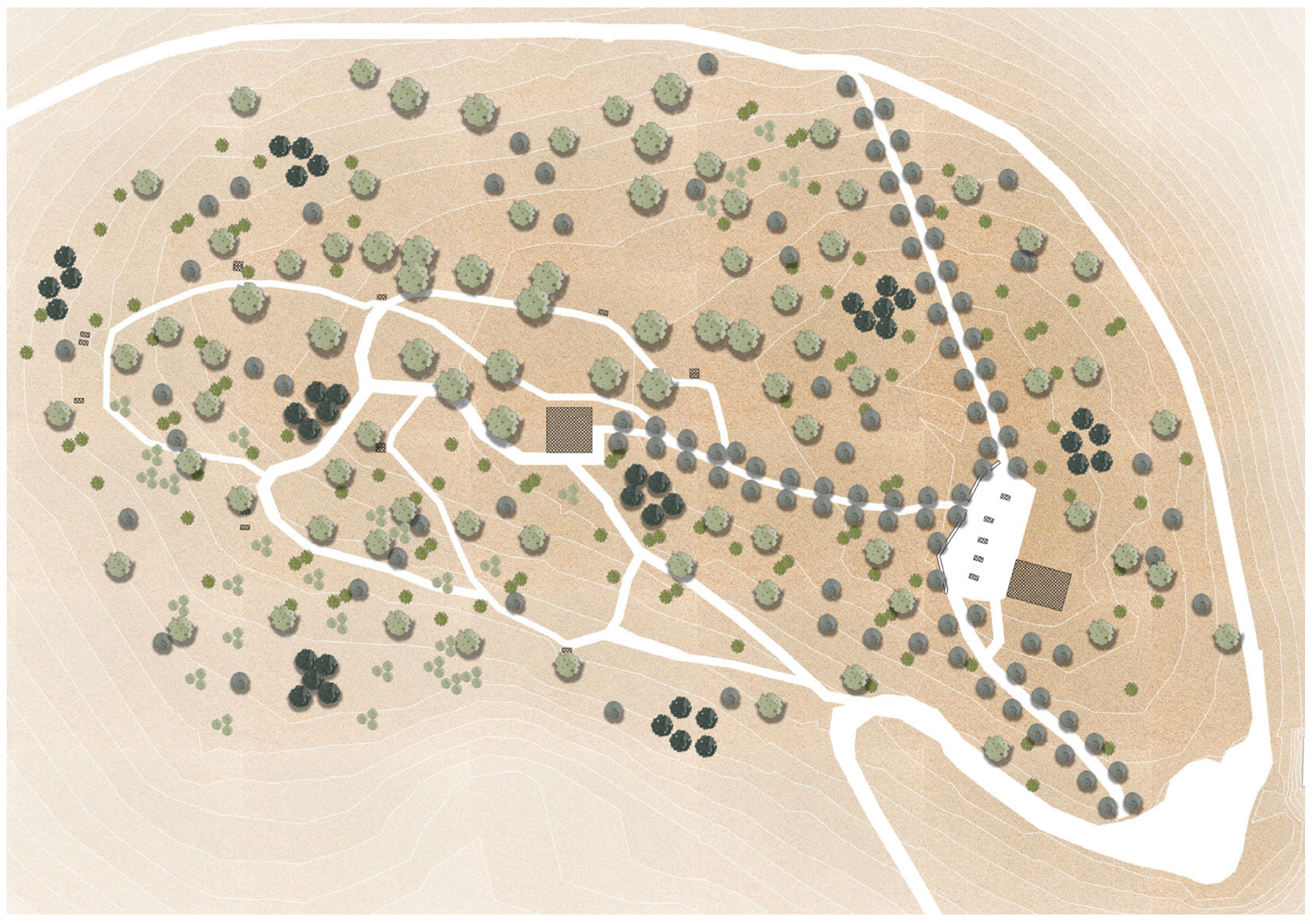
  • In the area where the vegetation patch survives, covering approximately 4500 m2, thinning of the vegetation patch was proposed, reducing the tree density to achieve the desired fuel break vegetation structure;
  • In the area where there was high natural regeneration, it was proposed to aid the natural regeneration, which is considered the best restoration method, in combination with planting a few large-sized Aleppo pine seedlings to immediately improve the appearance of the area;
  • In the area where natural regeneration has been disrupted due to recent landscaping work (2023), it was proposed to plant seedlings of the same age as the naturally regenerated seedlings.
In the area where the vegetation patch was preserved, tree thinning should be applied so that the vegetation structure adapts to the requirements of a fire break zone, as analyzed above. From the measurements of the existing vegetation in the patch, it was found that the tree density was 33 trees per 100 m2, and the relative ratio of species was approximately 1:9, pines to cypresses. Based on the above measurements, the total number of trees in the 4500 m2 vegetation patch were estimated to be approximately 1500, of which 150 are pines and 1350 are cypresses.
To achieve the desired conditions for a fuel break zone, it was proposed to retain 10% of the existing trees. Tree removal should be carried out in such a way as to maintain the existing species ratio. This intervention is expected to achieve the desired canopy fragmentation for the creation of a fire break zone (canopy cover up to 40%) and improve the health of the remaining trees by reducing competitive conditions within the stand. Finally, any trees whose canopy extends less than 5 m from the mausoleum walls should be removed.
As mentioned, measurements of the density of young regenerating Aleppo pine seedlings (in 2023, two years after the fire) in the cemetery area found that it was very high at 18.33 ± 4.11 per m2. This density is considered high and capable of achieving full forest regeneration in the area [2,3,4,7]. To support natural regeneration and adapt the area to the requirements of a fire break zone, thinning was proposed. It was suggested that thinning be carried out ten years after the fire, in 2031, during which the lower seedlings (seedlings with more limited growth) will be removed [2,7]. Thinning is proposed to be conducted ten years after the fire, in 2031, considering that the survival and density of young seedlings have been found to decrease during natural regeneration, 5–20 years after a fire, due to competitive conditions [2]. Before thinning is implemented, new measurements of the density of the new trees should be taken to determine the degree of thinning. The thinning should meet the requirements of a fire break zone [27], as analyzed above. Thinning is expected to improve and accelerate the development of the new forest, enhancing the quality of the new trees and increasing their growth rate by improving competitive conditions.
Alongside the natural regeneration of Aleppo pines and for the immediate improvement of the area’s appearance, it is proposed to plant some large-sized Aleppo pine seedlings, as well as cypress trees.
In areas where the terrain and natural regeneration have been disrupted due to recent landscaping interventions (2023), the additional planting of new Aleppo pine seedlings is recommended. These seedlings should be of the same age as the naturally regenerated ones at the time of project implementation. It is suggested that they be grown in peat containers or similar, which protect the roots from transplant shock, as they are not removed. Alternatively, bare-root seedlings can be planted, though a higher failure rate is expected [8]. In these areas, thinning should also be carried out ten years after the fire, in 2031, to achieve canopy fragmentation for creating a fire break zone. The degree of thinning should be determined later after calculating the survival rate of the new seedlings, although it will be much less than the degree of thinning for natural regeneration.
The new plantings also include the restoration of cypress rows along three of the cemetery pathways. The planting distances of the cypress rows should match, where possible, the measurements taken from the remnants of cypress trunks preserved in the area, combined with the requirements of the fire break zone [27] (Doxiadis et al., 2022).
In addition to pines, the planting of oaks (Quercus sp.) and shrubs in the understory, such as kermes oaks (Quercus coccifera) and strawberry trees (Arbutus unedo), is proposed, following the requirements of the fire break zone.

3.2. Restoration and Conservation of the Historical Pathways

As mentioned in the analysis of the current state of the paths, in some parts of these paths, the outline made by semi-carved stones is preserved. We propose cleaning these stone outlines mechanically, using brushes to remove accumulated loose materials.
In areas without a stone outline, it is suggested that new stones, 30 × 10 × 10 cm, be added, matching those already in the area.
For the restoration of the path surfaces, it is proposed to construct pebble floors. As mentioned, rounded aggregates with a maximum diameter of approximately 10 cm were found along the paths, indicating the presence of a layer, possibly with a soil-based binding material that has deteriorated. For restoration, it is proposed to spread a 6 cm thick clay mortar layer, on which pebbles of similar color and diameter range to the original will be placed. The proposed clay mortar to be used contains quartz sand, river sand, black pebbles, clay, and hydraulic lime.
It should be noted that similar pebble floors are well preserved in many parts of the Tatoi estate. In these areas, the floors are preserved under newer layers.

4. Discussion

A comprehensive analysis of the existing conditions at the Tatoi estate shows that the fire significantly impacted the vegetation of the area. The near-total eradication of the vegetation on Palaeokastro hill underscores the vulnerability of Mediterranean ecosystems to fire, a finding consistent with previous studies highlighting the flammability of Aleppo pine forests [13,30]. The surviving cypress and Aleppo pine trees and new Aleppo pine seedlings provide a foundation for natural regeneration, aligning with the regenerative capabilities observed in similar ecosystems [5,6,7].
The restoration proposals emphasize creating a firebreak zone by thinning vegetation, assisting natural regeneration, and planting new seedlings. These measures are designed to mitigate future fire risks and promote sustainable vegetation recovery. We recommend thinning the existing vegetation to create a firebreak zone, which will help prevent crown fires. These measures align with previous research on the importance of managing both surface and aerial fuel to reduce fire risk [13,19].
This study’s proposals for restoring historical landmarks, particularly the cypress-lined pathways and alleys, are crucial for preserving the cultural heritage of the Tatoi estate. These efforts align with international guidelines for cultural landscape management, which emphasize the importance of maintaining both the tangible and intangible elements that contribute to the spirit of place [34].
As a historical site, the Tatoi estate requires a nuanced approach that balances ecological recovery with cultural heritage preservation. The restoration of natural elements, such as the Aleppo pine forests, is complemented by efforts to restore the estate’s historical landmarks, ensuring the continuity of its cultural narrative. The estate’s designation as a historical site places particular importance on restoring not only the physical landscape but also the ‘spirit of place’—the unique character and emotional resonance it holds for both locals and visitors. This approach aligns with international heritage conservation guidelines, which advocate for preserving the symbolic and experiential aspects of such sites, as outlined in the Quebec Declaration on the spirit of place [34]. By integrating fire resilience and cultural heritage preservation, this restoration strategy could serve as a model for managing other historical sites affected by similar environmental challenges.

5. Conclusions

This study assessed the impact of the 2021 wildfire on the Tatoi estate, specifically the cemetery on Palaeokastro hill, and proposed a restoration plan that combines ecological and cultural heritage principles. The hypothesis—that targeted ecological restoration and fire-prevention measures can support sustainable recovery while preserving the cemetery’s historical significance—was tested through a detailed examination of vegetation recovery, historical landmarks, and fire management strategies.
A comprehensive analysis of the existing conditions revealed significant damage to the cemetery’s vegetation, particularly in the fire-prone Aleppo pine forests. The presence of scattered mature trees and a high density of Aleppo pine seedlings demonstrates a natural regeneration capacity. Our restoration proposals centered on creating a firebreak zone by managing vegetation density, supporting natural regeneration, and supplementing it with large-sized seedlings to both restore the landscape’s appearance and enhance fire resilience. These ecological restoration strategies align with the best practices in Mediterranean forest management, emphasizing the importance of canopy fragmentation and surface fuel reduction to mitigate crown fire risks.
In terms of cultural heritage preservation, this study’s recommendations focus on restoring historical landscape features, such as the cypress-lined pathways, which contribute to the site’s character and the ‘spirit of place’ as described in international heritage frameworks. These efforts aim to ensure that the Tatoi estate remains a site of cultural memory while adapting to new environmental realities.
The integrated restoration approach outlined here not only meets the objectives of ecological recovery and fire protection but also preserves the historical and aesthetic elements that define the Tatoi estate. This dual-focus strategy serves as a potential model for managing other historical sites affected by environmental challenges, demonstrating how heritage conservation and sustainable landscape management can work hand in hand. Further research could refine specific restoration techniques and their application across other culturally significant sites, contributing to the broader field of cultural landscape management in fire-prone regions.
Future research could focus on the long-term monitoring of vegetation recovery and fire resilience at the Tatoi estate, refining restoration techniques specific to historical sites with similar ecological characteristics. Further studies might explore integrating more fire-resistant vegetation types and landscape features in the design of heritage sites, contributing to broader strategies in cultural landscape management within fire-prone regions.

Author Contributions

Conceptualization, E.K. and T.D.; methodology, E.K. and T.D.; formal analysis, E.K. and T.D.; investigation, E.K. and T.D.; resources, E.K. and T.D.; data curation, E.K. and T.D.; writing—original draft preparation, E.K. and T.D.; writing—review and editing, E.K. and T.D.; visualization, E.K. and T.D.; supervision, T.D.; project administration, T.D.; funding acquisition, T.D. All authors have read and agreed to the published version of the manuscript.

Funding

This research received no external funding.

Institutional Review Board Statement

Not applicable.

Informed Consent Statement

Not applicable.

Data Availability Statement

Τhe data presented in this study are available on request from the corresponding author.

Conflicts of Interest

EK is an external partner and TD is the Director, of Doxiadis+ Company. The authors declare that the research was conducted in the absence of any commercial or financial relationships that could be construed as a potential conflict of interest.

References

  1. Vallejo, V.R.; Arianoutsou, M.; Moreira, F. Fire Ecology and Post-Fire Restoration Approaches in Southern European Forest Types. In Post-Fire Management and Restoration of Southern European Forests; Moreira, F., Arianoutsou, M., Corona, P., De las Heras, J., Eds.; Managing Forest Ecosystems; Springer: Dordrecht, The Netherlands, 2012; Volume 24. [Google Scholar] [CrossRef]
  2. de las Heras, J.; Moya, D.; Vega, J.A.; Daskalakou, E.; Vallejo, V.R.; Grigoriadis, N.; Tsitsoni, T.; Baeza, J.; Valdecantos, A.; Fernández, C.; et al. Post-Fire Management of Serotinous Pine Forests. In Post-Fire Management and Restoration of Southern European Forests; Moreira, F., Arianoutsou, M., Corona, P., De las Heras, J., Eds.; Managing Forest Ecosystems; Springer: Dordrecht, The Netherlands, 2012; Volume 24. [Google Scholar] [CrossRef]
  3. Thanos, C.A.; Daskalakou, E.N. Reproduction in Pinus halepensis and P. brutia. In Ecology, Biogeography and Management of Pinus halepensis and P. brutia Forest Ecosystems in the Mediterranean Basin; Ne’eman, G., Trabaud, L., Eds.; Backhuys Publishers: Leiden, The Netherlands, 2000; pp. 79–90. [Google Scholar]
  4. Tsitsoni, T. Conditions Determining Natural Regeneration after Wildfires in the Pinus halepensis (Miller, 1768) Forests of Kassandra Peninsula (North Greece). For. Ecol. Manag. 1997, 92, 199–208. [Google Scholar] [CrossRef]
  5. Zagas, T. Research on the Natural Regeneration of Pinus halepensis after a Forest Fire in the Mount Pateras Area. Sci. Ann. Sch. For. Nat. Environ. Aristotle Univ. Thessalon. 1987, 30, 303–327. [Google Scholar]
  6. Moya, D.; de las Heras, J.; López-Serrano, F.R.; Leone, V. Optimal Intensity and Age of Management in Young Aleppo Pine Stands for Post-Fire Resilience. For. Ecol. Manag. 2008, 255, 3270–3280. [Google Scholar] [CrossRef]
  7. Tsitsoni, T.; Ganatsas, P.; Zagas, T.; Tsakaldimi, M. Dynamics of Post-Fire Regeneration of Pinus brutia Ten. in an Artificial Forest Ecosystem of Northern Greece. Plant Ecol. 2004, 171, 165–174. [Google Scholar] [CrossRef]
  8. Zagas, T.; Ganatsas, P.; Tsitsoni, T.; Tsakaldimi, M. Post-Fire Regeneration of Pinus halepensis Mill. Stands in the Sithonia Peninsula, Northern Greece. Plant Ecol. 2004, 171, 91–99. [Google Scholar] [CrossRef]
  9. Karali, A.; Hatzaki, M.; Giannakopoulos, C.; Roussos, A.; Xanthopoulos, G.; Tenentes, V. Sensitivity and Evaluation of Current Fire Risk and Future Projections Due to Climate Change: The Case Study of Greece. Nat. Hazards Earth Syst. Sci. 2014, 143, 143–153. [Google Scholar] [CrossRef]
  10. Vasilakos, C. Remote Sensing, Artificial Intelligence, and Geographic Information Systems in Forest Fire Risk Assessment. Ph.D. Thesis, University of the Aegean, Mytilene, Greece, 2007. [Google Scholar]
  11. Mouillot, F.; Rambal, S.; Joffre, R. Simulating Climate Change Impacts on Fire Frequency and Vegetation Dynamics. Glob. Change Biol. 2002, 8, 423–437. [Google Scholar] [CrossRef]
  12. Dimitrakopoulos, A. Mediterranean Fuel Models and Potential Fire Behaviour in Greece. Int. J. Wildland Fire 2002, 11, 127–130. [Google Scholar] [CrossRef]
  13. Mitsopoulos, I. Analysis and Management of Canopy Fires in Aleppo Pine Forests. Ph.D. Thesis, Aristotle University of Thessaloniki, Thessaloniki, Greece, 2005. [Google Scholar]
  14. Graham, R.T. Hayman Fire Case Study; General Technical Report RMRS-GTR-114; United States Department of Agriculture (USDA), Forest Service, Rocky Mountain Research Station: Fort Collins, CO, USA, 2003; p. 396.
  15. Scott, J.H.; Reinhardt, E.D. Assessing Crown Fire Potential by Linking Models of Surface and Crown Fire Potential; Research Paper RMRS-29; USDA, Forest Service, Rocky Mountain Research Station: Fort Collins, CO, USA, 2001; p. 59.
  16. Alexander, M.E. Fire Behavior as a Factor in Forest and Rural Fire Suppression; Forest Research Bulletin, Forest and Rural Fire Scientific and Technical Series No. 5; New Zealand Forest Research Institute Limited: Wellington, New Zealand, 2000; p. 28. [Google Scholar]
  17. Albini, F.A.; Stocks, B.J. Predicted and Observed Rates of Spread of Crown Fires in Immature Jack Pine. Combust. Sci. Technol. 1986, 48, 65–76. [Google Scholar] [CrossRef]
  18. Wade, D.D.; Ward, D.E. An Analysis of the Air Force Bomb Range Fire; Research Paper SE-105; United States Department of Agriculture (USDA), Forest Service, Southeast Forest and Range Experiment Station: Asheville, NC, USA, 1973; p. 38.
  19. Cruz, M.G. Modeling the Initiation and Spread of Crown Fires. Master’s Thesis, University of Montana, Missoula, MT, USA, 1999; p. 162. [Google Scholar]
  20. Peterson, D.L.; Johnson, M.C.; Agee, J.K.; Jain, T.B.; McKenzie, D.; Reinhardt, E.D. Forest Structure and Fire Hazard in Dry Forests of the Western United States; General Technical Report GTR-628; USDA, Forest Service, Pacific Northwest Research Station: Portland, OR, USA, 2005; p. 30.
  21. Fiedler, C.E.; Keegan, C.E.; Woodall, C.W.; Morgan, T.A. A Strategic Assessment of Crown Fire Hazard in Montana: Potential Effectiveness and Costs of Hazard Reduction Treatments; General Technical Report GTR-622; United States Department of Agriculture (USDA) Forest Service, Pacific Northwest Research Station: Portland, OR, USA, 2004; p. 48.
  22. Pollet, J.; Omi, P. Effect of Thinning and Prescribed Burning on Crown Fire Severity in Ponderosa Pine Forests. Int. J. Wildland Fire 2002, 11, 1–10. [Google Scholar] [CrossRef]
  23. Fiedler, C.E.; Arno, S.F.; Harrington, M.G. Reintroducing Fire in Ponderosa Pine-Fir Forests after a Century of Fire Exclusion. In Proceedings of the Tall Timbers Fire Ecology Conference; Pruden, T., Brennan, L., Eds.; Tall Timbers Research Station: Tallahassee, FL, USA, 1998; pp. 245–249. [Google Scholar]
  24. Fiedler, C.E. Silvicultural Applications: Restoring Ecological Structure and Process in Ponderosa Pine Forests; General Technical Report INT-341; United States Department of Agriculture (USDA), Forest Service, Intermountain Forest and Range Experiment Station: Ogden, UT, USA, 1996; p. 86.
  25. Van Wagtendonk, J. Use of a Deterministic Fire Growth Model to Test Fuel Treatments. In Sierra Nevada Ecosystem Project: Final Report to Congress, Volume II: Assessments and Scientific Basis for Management Options; Report Note 37; University of California, Davis, Center for Water and Wildland Resources: Davis, CA, USA, 1996; pp. 1155–1165. [Google Scholar]
  26. Karetsos, G. Preliminary Study-Preservation of Vegetation and Restoration Possibilities of the Garden and the Aesthetic Forest of the Summer Palace at the Former Royal Estate of Tatoi; Mediterranean Forest Ecosystems Institute, HAO “Demeter”: Athens, Greece, 2014. [Google Scholar]
  27. Doxiadis, T.; Potiriadis, I.; Golemi, C. Post-Fire Vegetation Management in the Fire-Affected Area of 2018 of Nea Makri and Rafina Municipal Units, Guidelines; Doxiadis+: Athens, Greece, 2022. [Google Scholar]
  28. DaCamara, C.; Calado, T.; Ermida, S.; Trigo, I.; Amraoui, M.; Turkman, K. Calibration of the Fire Weather Index over Mediterranean Europe Based on Fire Activity Retrieved from MSG Satellite Imagery. Int. J. Wildland Fire 2014, 23, 121–133. [Google Scholar] [CrossRef]
  29. Ager, A.; Preisler, H.; Arca, B.; Spano, D.; Salis, M. Wildfire risk estimation in the Mediterranean area. Environmetrics 2014, 25, 384–396. [Google Scholar] [CrossRef]
  30. Spanos, I. Silviculture and Management of the Forests of Brutia and Aleppo Pine in Our Country Aiming at Multiple Use of Forests (Protection and Provision of Goods and Services). Sci. Yearb. Dep. For. Nat. Environ. 1992, 35, 1069–1081. [Google Scholar]
  31. Dafis, S. Ecology of the Forests of Aleppo and Brutia Pine. In Proceedings of the Scientific Meeting, Chalkida, Greece, 30 September–2 October 1987; Hellenic Forestry Society: Thessaloniki, Greece, 1987; pp. 17–25. [Google Scholar]
  32. National Law 3028/A/28-6-2002 of the Greek Republic of 28 June 2002 for the protection of antiquities and cultural heritage (Government Gazette A’153/28-6-2002). Gov. Gaz. Greek Repub. 2002, 153, 3003.
  33. International Council on Monuments and Sites (ICOMOS). Cultural Landscapes: Management and Conservation; ICOMOS Documentation Centre: Paris, France, 2013. [Google Scholar]
  34. International Council on Monuments and Sites (ICOMOS). Quebec Declaration on the Preservation of the Spirit of Place; ICOMOS: Quebec, QC, Canada, 2008. [Google Scholar]
  35. Google Earth. Map of Attica [Satellite Image]. 2024. Available online: https://earth.google.com/ (accessed on 18 October 2023).
  36. Google Earth. Tatoi Estate [Satellite Image]. 2024. Available online: https://earth.google.com/ (accessed on 6 April 2023).
  37. Mavromatis, G. Bioclimatic Map of Greece; Ministry of Agriculture, Forest Research Institute of Athens, Department of Forest Meteorology: Athens, Greece, 1978.
  38. Mavromatis, G. Vegetation Map of Greece; Ministry of Agriculture, Forest Research Institute of Athens, Department of Forest Meteorology: Athens, Greece, 1978.
  39. Parnitha National Park Management Agency. Fauna of Parnitha. Available online: https://parnitha.net/en/?page_id=1936 (accessed on 25 October 2024).
  40. National Law 1620/Β/3-11-2003 of the Greek Republic of 3 November 2003 designation as monuments of all the individual buildings of the former Royal Estate at Tatoi in Attica and as a historic site of the central part (Government Gazette Β’1620/3-11-2003). Gov. Gaz. Greek Repub. 2003, 1620, 22616–22617.
  41. Stamatopoulos, K. The Chronicle of Tatoi; Kapon Editions: Athens, Greece, 2004; Volume A, pp. 38, 43, 58, 83, 100–101, 214, 249, 382, 432; Volume B, pp. 25, 46, 62–64, 92–94, 106–108, 111, 133, 142, 144, 146, 164, 174, 189, 196–198, 223, 288. [Google Scholar]
  42. Kaupert, J. Maps of Attica, B1 XX Tatoi; Edited by the German Archaeological Institute; Melissa Publishing House: Athens, Greece.
  43. Google Earth. Tatoi Estate Cemetery [Satellite Image]. 2021. Available online: https://earth.google.com/ (accessed on 18 October 2023).
  44. Google Earth. Tatoi Estate Cemetery [Satellite Image]. 2023. Available online: https://earth.google.com/ (accessed on 18 October 2023).
Figure 1. Satellite image of the position of the estate on the eastern foothills of Mount Parnitha in Attica (central Greece) [35].
Architecture 05 00007 g001
Figure 2. Satellite image of the position of the study area in the Tatoi estate, on the hill of Palaeokastro [36].
Architecture 05 00007 g002
Figure 3. Satellite image of the cemetery area on Palaeokastro hill before the fire, in June 2021 [43].
Architecture 05 00007 g003
Figure 4. Satellite image of the cemetery area Palaeokastro hill after the fire, in May 2023 [44].
Architecture 05 00007 g004
Figure 5. Preserved elements of historical paths: (a) a path bordered by semi-carved stones and paved with rounded gravel; (b) rounded gravel paving in detail; (c) semi-carved border stone in detail; (d) a path with remnants of linear cypress plantings, with the bases of the trunks still present.
Architecture 05 00007 g005
Table 1. Mean monthly temperature and precipitation of the study area (Hellenic National Meteorological Service, meteorological data for the period 1956–2010).
MonthAir Temperature (°C)Rain (mm)
January7.467.5
February7.850.9
March10.149.7
April14.324.6
May19.723.2
June24.710.3
July27.010.9
August26.65.5
September22.219.2
October17.151.3
November12.559.2
December9.079.7
Disclaimer/Publisher’s Note: The statements, opinions and data contained in all publications are solely those of the individual author(s) and contributor(s) and not of MDPI and/or the editor(s). MDPI and/or the editor(s) disclaim responsibility for any injury to people or property resulting from any ideas, methods, instructions or products referred to in the content.

