
Relationship Between Lithological and Morphometric Aspects of Mascasín Saline Watershed and Its Feeder Depositional Systems, San Juan and La Rioja Provinces, Argentina

Abstract
1. Introduction
2. Geological Setting


2.1. Geomorphologic Setting
2.2. Climate
3. Materials and Methods
4. Results
4.1. Parent Rocks Composition
4.2. Morphometry
4.3. Cluster Analysis
4.3.1. Correlation Matrix
4.3.2. Clustering
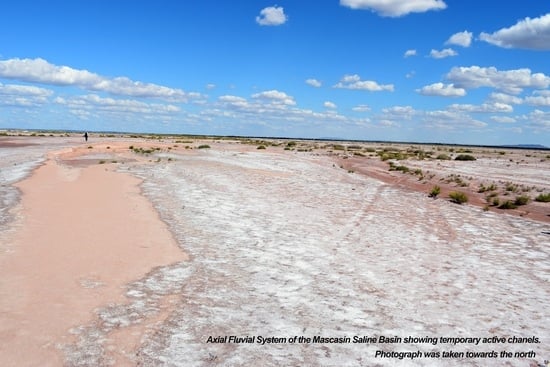
4.4. Depositional Areas
5. Discussion
5.1. Parent Rock Composition and Clustering
5.2. Parameters That Influence Depositional Areas
5.3. Role of Morphometric Parameters in Papagayos DFS Occurrence
6. Conclusions
Supplementary Materials
Author Contributions
Funding
Data Availability Statement
Conflicts of Interest
Appendix A
Appendix A.1. Drainage Basins (Section 4.1)

Appendix A.2. Exploratory Data Analysis (Section 4.3)

| Variable | Mean | sd | n |
|---|---|---|---|
| Area_cca | 293.00 | 334.24 | 26 |
| Perim_cca | 90.92 | 61.08 | 26 |
| Clima | 298.69 | 68.46 | 26 |
| Hr | 0.8484615 | 0.70059799 | 26 |
| Dd | 6.079 | 7.125 | 26 |
| %IG | 40.23 | 43.11 | 26 |
| %Met | 15.84 | 24.16 | 26 |
| %RSED | 38.88 | 45.42 | 26 |
| Deparea | 33.83 | 51.04 | 26 |
| L (km) | 28.65 | 13.59 | 26 |
| Kc | 1.633 | 0.31554105 | 26 |
| C | 0.4026923 | 0.12919931 | 26 |
| E | 0.5842308 | 0.09617372 | 26 |
| Ff | 0.2753846 | 0.09326224 | 26 |
| Rr | 0.0300000 | 0.02280351 | 26 |
Histograms and Boxplot

Appendix A.3. Dataset Used in the Hierchical Clutsering (Section 4.4)

Appendix A.4. Topographic Profles

References
- Blair, T.; Mcpherson, J. Alluvial fans and their natural distinction from rivers based on morphology, hydraulic processes, sedimentary processes, and facies assemblages. J. Sediment. Res. 1994, A64, 450–489. [Google Scholar]
- Tucker, G.E.; Slingerland, R. Drainage basin responses to climate change. Water Resour. Res. 1997, 33, 2031–2047. [Google Scholar] [CrossRef]
- Le Pera, E.; Arribas, J.; Critelli, S.; Tortosa, A. The effects of source rocks and chemical weathering on the petrogenesis of siliciclastic sand from the Neto River (Calabria, Italy): Implications for provenance studies. Sedimentology 2001, 48, 357–378. [Google Scholar] [CrossRef]
- Thorpe, M.T.; Hurowitz, J.A. Unraveling sedimentary processes in fluvial sediments from two basalt dominated watersheds in northern Idaho, USA. Chem. Geol. 2020, 550, 119673. [Google Scholar] [CrossRef]
- Marchi, L.; Dalla Fontana, G. GIS morphometric indicators for the analysis of sediment dynamics in mountain basins. Environ. Geol. 2020, 48, 218–228. [Google Scholar] [CrossRef]
- Melton, M.A. An Analysis of the Relations Among Elements of Climate, Surface Properties, and Geomorphology; Columbia Univ.: New York, NY, USA, 1957; pp. 1–99. [Google Scholar]
- Melton, M.A. The geomorphic and paleoclimatic significance of alluvial deposits in southern Arizona. J. Geol. 1965, 73, 1–38. [Google Scholar] [CrossRef]
- Viaplana-Muzas, M.; Babault, J.; Dominguez, S.; Van Den Driessche, J.; Legrand, X. Drainage network evolution and patterns of sedimentation in an experimental wedge. Tectonophysics 2015, 664, 109–124. [Google Scholar] [CrossRef]
- Dickinson, W.R.; Suczek, C.A. Plate tectonics and sandstone compositions. Aapg Bull. 1979, 63, 2164–2182. [Google Scholar]
- Dickinson, W.R. Provenance and sediment dispersal in relation to paleotectonics and paleogeography of sedimentary basins. In New Perspectives in Basin Analysis; Springer: New York, NY, USA, 1988; pp. 3–25. [Google Scholar] [CrossRef]
- Tooth, S.; Nanson, G.C. Anabranching rivers on the Northern Plains of arid central Australia. Geomorphology 1999, 29, 211–233. [Google Scholar] [CrossRef]
- Weltie, G.J.; Von Eynatten, H. Quantitative provenance analysis of sediments: Review and outlook. Sediment. Geol. 2004, 171, 1–11. [Google Scholar] [CrossRef]
- Jain, M.; Tandon, S.K. Quaternary alluvial stratigraphy and palaeoclimatic reconstruction at the Thar margin. Curr. Sci. 2003, 84, 1048–1055. [Google Scholar]
- Tucker, G.E.; Bras, R.L. Hillslope processes, drainage density, and landscape morphology. Water Resour. Res. 1998, 34, 2751–2764. [Google Scholar] [CrossRef]
- Schumm, S.; Hadley, R. Progress in the Application of Landform Analysis in Studies of Semiarid Erosion; US Department of the Interior Geological Survey Circular: Washington, DC, USA, 1961; Volume 437, pp. 1–14. [Google Scholar]
- Bookhagen, B.; Strecker, M.R. Spatiotemporal trends in erosion rates across a pronounced rainfall gradient: Examples from the southern Central Andes. Earth Planet. Sci. Lett. 2012, 327, 97–110. [Google Scholar] [CrossRef]
- Tucker, G.E.; Hancock, G.R. Modelling landscape evolution. Earth Surf. Process. Landf. 2010, 35, 28–50. [Google Scholar] [CrossRef]
- Migoń, P.; Duszyński, F. Landscapes and landforms in coarse clastic sedimentary tablelands–is there a unifying theme? Catena 2022, 218, 106545. [Google Scholar] [CrossRef]
- Yunus, A.P.; Oguchi, T.; Hayakawa, Y.S. Morphometric Analysis of Drainage Basins in the Western Arabian Peninsula Using Multivariate Statistics. Int. J. Geosci. 2014, 5, 527–539. [Google Scholar] [CrossRef]
- Suvires, G. Geomorfología de la Provincia de San Juan. In Catálogo de Recursos Humanos e Información Relacionada con la Temática Ambiental en la Región Andina Argentina; Abraham, M.E., Rodríguez Martínez, F., Eds.; C-Bra Systematics GTZ: Buenos Aires, Argentina, 1996; Chapter 11. Available online: https://www.mendoza-conicet.gob.ar/ladyot/catalogo/cdandes/cap11.htm (accessed on 20 June 2017).
- Criado Roque, P.; Mombrú, C.A.; Ramos, V. Estructura e interpretación tectónica. In Geología y Recursos Naturales de la Provincia de San Luis, Proceedings of the VIII Congreso Geológico Argentino, San Luis, Argentina, 20–26 September 1981; Relatorio, Irigoyen, M., Eds.; 1981; pp. 155–192. Available online: https://www.researchgate.net/publication/284295627_Estructura_e_interpretacion_tectonica_en_Geologia_y_Recursos_Naturales_de_la_Provincia_de_San_Luis (accessed on 23 December 2024).
- Tripaldi, A.; Forman, S.L. Geomorphology and chronology of Late Quaternary dune fields of western Argentina. Palaeogeogr. Palaeoclimatol. Palaeoecol. 2007, 251, 300–320. [Google Scholar] [CrossRef]
- Azeglio, E.A.; Giménez, M.E.; Introcaso, A. Análisis de subsidencia de la Cuenca de las Salinas, Sierras Pampeanas occidentales. Rev. Asoc. Geológica Argent. 2008, 63, 272–280. [Google Scholar]
- Azeglio, E.A.; Gimenez, M.E.; Introcaso, A. Interpretation of Las Salinas sedimentary basin-Argentina, based on integration of geological and geophysical data. Geofísica Int. 2010, 49, 225–244. [Google Scholar] [CrossRef]
- Santi Malnis, P.; Colombi, C.E.; Rodríguez Posatini, N.; Rothis, L.M.; Limarino, C.O. Caracterización sedimentológica de un Sistema Fluvial Distributivo de clima árido: Arroyo Papagayos, en el piedemonte oriental de las Sierras La Huerta-Imanas, San Juan, Argentina. Andean Geol. 2018, 45, 186–228. [Google Scholar] [CrossRef]
- Suriano, J.; Limarino, C.O. Sedimentación pedemontana en las nacientes del Río Jáchal y Pampa de Gualilán, Precordillera de San Juan. Rev. Asoc. Geológica Argent. 2009, 65, 516–532. [Google Scholar]
- Colombi, C.E.; Santi Malnis, P.; Martínez, R.N.; Drovandi, J.M.; Correa, G.A.; Soria Pures, T.B. Revisión estratigráfica y evolución paleoambiental del mesozoico temprano al sureste de la provincia de San Juan, Argentina. Rev. Asoc. Geológica Argent. 2021, 784, 449–486. [Google Scholar]
- Jordan, T.; Isacks, B.; Allmendinger, R.W.; Brewe, J.A.; Ramos, V.A.; Ando, C.J. Andean tectonics related to geometry of subducted Nazca plate. GSA Bull. 1983, 94, 341–361. [Google Scholar] [CrossRef]
- Bossi, G. Geología de la Cuenca de Marayes-El Carrizal (Provincia de San Juan), República Argentina. In Proceedings of the Actas del VI Congreso Geológico Argentino, I, Bahia Blanca, Argentina, 21–27 September 1976; pp. 23–38. [Google Scholar]
- Vujovich, G.; Chernicoff, C.; Tchilinguirian, P.; Godeas, M.; Marín, G.; Pezzutti, N.; Diaz, I. Hoja Geológica 3166-III. Chepes, provincias de La Rioja, San Juan y San Luis, Buenos Aires. Bol. Serv. Geol. Argent. 2007, 251, 1–65. [Google Scholar]
- Net, L.; Limarino, O. Paleogeografía y correlación estratigráfica del Paleozoico Tardío de la Sierra de Los Llanos, provincia de La Rioja, Argentina. Rev. Asoc. Geológica Argent. 1999, 54, 229–239. [Google Scholar]
- Rothis, L.M.; Haro, F.M.; Perucca, L.P.; Santi Malnis, P.; Alcacer, J.M.; Vargas, N. Morphotectonic Analysis in the Eastern Piedmont of the Sierra de La Huerta, Western Sierras Pampeanas, San Juan, Argentina; Advances in Geomorphology and Quaternary Studies in Argentina: Special Symposium from the Argentine Association of Geomorphology and Quaternary Studies; Springer International Publishing: Cham, Switzerland, 2020; pp. 114–128. [Google Scholar] [CrossRef]
- Bastías, H.; Uliarte, E.; Paredes, J.; Sanchez, A.; Bastías, J.; Ruzycki, L.; Perucca, L. Neotectónica de la provincia de San Juan. In 11º Congreso Geológico Argentino; Bordonaro, O., Ed.; Relatorio de Geología y Recursos Naturales de la Provincia de San Juan: San Juan, Argentina, 1990; pp. 228–245. [Google Scholar]
- Rothis, L.M.; Perucca, L.P.; Santi Malnis, P.; Alcacer, J.M.; Haro, F.M.; Vargas, H.N. Neotectonic, morphotectonic and paleoseismologic analysis of the Las Chacras Fault System, Sierras Pampeanas Occidentales, San Juan, Argentina. J. S. Am. Earth Sci. 2019, 91, 144–153. [Google Scholar] [CrossRef]
- Rothis, L.M. Análisis de la Actividad Tectónica Cuaternaria en el Sector sur de la Falla Las Chacras y Evaluación de la Peligrosidad Sísmica. Sierras Pampeanas Occidentales. Provincia de San Juan. Doctoral Thesis, National University of San Juan, San Juan, Argentina, 2016. [Google Scholar]
- Costa, C.H.; Gardini, C.E.; Ortíz Suárez, A.E.; Chiesa, J.O.; Ojeda, G.E.; Rivarola, D.L.; Strasser, E.; Morla, P.; Ulaco, J.; Tornelli, G.; et al. Hoja Geológica 3366-I San Francisco del Monte de Oro; Instituto de Geologia y Recursos Minerales, Servicio Geológico Minero Argentino Boletin: Buenos Aires, Argentina, 2001; 278p. [Google Scholar]
- Löbens, S.; Bense, F.A.; Dunkl, I.; Wemmer, K.; Kley, J.; Siegesmund, S. Thermochronological constraints of the exhumation and uplift of the Sierra de Pie de Palo, NW Argentina. J. S. Am. Earth Sci. 2013, 48, 209–219. [Google Scholar] [CrossRef]
- Bense, F.; Costa, C.; Oriolo, S.; Löbens, S.; Dunkl, I.; Wemmer, K.; Siegesmund, S. Exhumation history and landscape evolution of the Sierra de San Luis (Sierras Pampeanas, Argentina)-new insights from low-temperature thermochronological data. Andean Geol. 2017, 44, 275. [Google Scholar] [CrossRef][Green Version]
- Ezpeleta, M.; Dávila, F.M.; Astini, R.A. Estratigrafía y paleoambientes de la Formación Los Llanos (La Rioja): Una secuencia condensada miocena en el antepaís fragmentado andino central. Rev. Asoc. Geológica Argent. 2006, 61, 171–186. [Google Scholar]
- Cioccale, M.A. Climatic fluctuations in the Central Region of Argentina in the last 1000 years. Quat. Int. 1999, 62, 35–47. [Google Scholar] [CrossRef]
- Garzanti, E.; Capaldi, T.; Tripaldi, A.; Zárate, M.; Limonta, M.; Vezzoli, G. Andean retroarc-basin dune fields and Pampean Sand Sea (Argentina): Provenance and drainage changes driven by tectonics and climate. Earth-Sci. Rev. 2022, 231, 104077. [Google Scholar] [CrossRef]
- Sitio del Servicio Meteorológico Nacional Argentino. 2020. Available online: https://www.smn.gob.ar/clima/vigilancia (accessed on 29 October 2024).
- INTA Digital Geo. 2023. Available online: https://geo.inta.gob.ar/es#7.1/-30.623/-67.604 (accessed on 29 October 2024).
- Karlin, M. Cambios temporales del clima en la subregión del Chaco Árido. Multequina 2012, 21, 3–16. [Google Scholar]
- Pereyra, B. Clima de la provincia de San Juan. In Catálogo de Recursos Humanos e Información Relacionada con la Tematica Ambiental en la Region Andina Argentina; Online (2000) C-Bra Systematics; GTZ en el marco de la Cooperación Técnica Argentino-Alemana: Buenos Aires, Argentina, 1996; Chapter 10. Available online: hhttps://www.conicet.gov.ar/new_scp/detalle.php?keywordsamp;id=20994amp;libros=yesamp;detalles=yesamp;lib_id=761727 (accessed on 20 December 2024).
- Beck, H.E.; Zimmermann, N.E.; McVicar, T.R.; Vergopolan, N.; Berg, A.; Wood, E.F. Present and future Köppen-Geiger climate classification maps at 1-km resolution. Sci. Data 2018, 5, 180214. [Google Scholar] [CrossRef] [PubMed]
- Marquez, J.; Martinez Carretero, E.E.; Dalmasso, A.D. Provincias fitogeográficas de la Provincia de San Juan. Repositorio Institucional CONICET Digital, 2016; pp. 187–197. Available online: https://ri.conicet.gov.ar/handle/11336/129240 (accessed on 20 December 2024).
- European Commission, Joint Research Centre (JRC). South America Mean Annual Precipitation Map (TRMM 3B43 dataset). European Commission, Joint Research Centre (JRC) [Dataset] PID. 2015. Available online: http://data.europa.eu/89h/3950386f-1b43-4247-8d99-40dd89f164a3 (accessed on 23 December 2024).
- Instituto Geográfico Nacional. Atlas Nacional Interactivo de Argentina [en línea]. Available online: https://www.ign.gob.ar/NuestrasActividades/Geodesia/ModeloDigitalElevaciones/Mapa (accessed on 5 January 2022).
- Conrad, O.; Bechtel, B.; Bock, M.; Dietrich, H.; Fischer, E.; Gerlitz, L.; Wehberg, J.; Wichmann, V.; Böhner, J. System for Automated Geoscientific Analyses (SAGA) v. 2.1.4. Geosci. Model Dev. 2015, 8, 1991–2007. [Google Scholar] [CrossRef]
- Strahler, A.N. Quantitative geomorphology of drainage basins and channel networks. In Handbook of Applied Hydrology; Chow, V.T., Ed.; McGraw-Hill: New York, NY, USA, 1964; pp. 4–39. [Google Scholar]
- QGIS.org. QGIS Geographic Information System. QGIS Association. 2024. Available online: https://www.qgis.org/ (accessed on 23 December 2024).
- Map Data ©Google. 2015. In QuickMapServices Version 0.19.33. Developer: NextGIS. Available online: https://www.google.at/permissions/geoguidelines/attr-guide.html (accessed on 23 December 2024).
- Horton, R.E. Erosional development of streams and their drainage basins; hydrophysical approach to quantitative morphology. Geol. Soc. Am. Bull. 1945, 56, 275–370. [Google Scholar] [CrossRef]
- Horton, R.E. Drainage-basin characteristics. Trans. Am. Geophys. Union 1932, 13, 350–361. [Google Scholar]
- Miller, V.C. A Quantitative Geomorphic Study of Drainage Basin Characteristics in the Clinch Mountain Area; Virginia and Tennessee, Proj. NR, Technical Report; Columbia University: New York, NY, USA, 1953; pp. 389–402. [Google Scholar]
- Schumm, S.A. Evolution of Drainage Systems & Slopes in Badlands at Perth, New Jersey. Bull. Geol. Soc. Am. 1956, 67, 597–646. [Google Scholar] [CrossRef]
- Hadley, R.; Schumm, S. Sediment Source and Drainage Basin Characteristics in Upper Cheyenne River Basin. US Geological Survey Water Supply Paper: 1961; 1531-B. Available online: https://www.semanticscholar.org/paper/B.-Sediment-Sources-and-Drainage-Basin-Character%C2%AD-Culler-Hadley/2c5c3e31a212b3a22e2719827c4f771d2418c00d (accessed on 23 December 2024).
- Gravelius, H. Grundrifi der gesamten Gewcisserkunde. In Band I: Flufikunde Compendium of Hydrology; Goschen: Berlin, Germany, 1914; Volume I. Rivers. (In German) [Google Scholar]
- Santi Malnis, P.; Colombi, C.E.; Rothis, L.M.; Alcober, O. Fluvial architecture and paleoenvironmental evolution of the Los Colorados Formation (Norian): Postrift stage of the Ischigualasto–Villa Unión Basin, NW Argentina. J. Sediment. Res. 2020, 90, 1436–1462. [Google Scholar] [CrossRef]
- Schencman, L.J.; Colombi, C.; Santi Malnis, P.; Limarino, C.O. Diagénesis y procedencia de la Formación Los Colorados (Noriano), Cuenca de Ischigualasto-Villa Unión, Noroeste de Argentina. Rev. Asoc. Geológica Argent. 2015, 72, 219–234. [Google Scholar]
- Hamilton, N.E.; Ferry, M. ggtern: Ternary Diagrams Using ggplot2. J. Stat. Softw. Code Snippets 2018, 87, 1–17. [Google Scholar] [CrossRef]
- Wickham, H. ggplot2: Elegant Graphics for Data Analysis; Springer: New York, NY, USA, 2016. [Google Scholar]
- Zeileis, A.; Köll, S.; Graham, N. Various Versatile Variances: An Object-Oriented Implementation of Clustered Covariances in R. J. Stat. Softw. 2020, 95, 1–36. [Google Scholar] [CrossRef]
- Wickham, H.; François, R.; Henry, L.; Müller, K.; Vaughan, D. dplyr: A Grammar of Data Manipulation. R Package Version 1.1.4. 2023. Available online: https://CRAN.R-project.org/package=dplyr (accessed on 23 December 2024).
- Kassambara, A.; Mundt, F. factoextra: Extract and Visualize the Results of Multivariate Data Analyses. R Package Version 1.0.7. 2020. Available online: https://CRAN.R-project.org/package=factoextra (accessed on 23 December 2024).
- Fox, J.; Weisberg, S.; Price, B. carData: Companion to Applied Regression Data Sets. R Package Version 2022 3.0-5. Available online: https://CRAN.R-project.org/package=carData (accessed on 23 December 2024).
- Meyer, D.; Dimitriadou, E.; Hornik, K.; Weingessel, A.; Leisch, F. e1071: Misc Functions of the Department of Statistics, Probability Theory Group (Formerly: E1071), TU Wien. R Package Version 1.7-14. 2023. Available online: https://CRAN.R-project.org/package=e1071 (accessed on 23 December 2024).
- Charrad, M.; Ghazzali, N.; Boiteau, V.; Niknafs, A. NbClust: An R Package for Determining the Relevant Number of Clusters in a Data Set. J. Stat. Softw. 2014, 61, 1–36. Available online: http://www.jstatsoft.org/v61/i06/ (accessed on 23 December 2024). [CrossRef]
- Genz, A.; Bretz, F. Computation of Multivariate Normal and t Probabilities; Series Lecture Notes in Statistics; Springer: Berlin/Heidelberg, Germany, 2009; ISBN 978-3-642-01688-2. [Google Scholar]
- Simko, V.R.; Wei, T. Package ‘corrplot’: Visualization of a Correlation Matrix (Version 0.92). 2021. Available online: https://github.com/taiyun/corrplot (accessed on 23 December 2024).
- Wickham, H.; Miller, E.; Smith, D. Haven: Import and Export ‘SPSS’, ‘Stata’ and ‘SAS’ Files. R Package Version 2.5.3. 2023. Available online: https://CRAN.R-project.org/package=haven (accessed on 23 December 2024).
- Fox, J.; Marquez, M. RcmdrMisc: R Commander Miscellaneous Functions. R Package Version 2.9-1. 2023. Available online: https://CRAN.R-project.org/package=RcmdrMisc (accessed on 23 December 2024).
- Kassambara, A. rstatix: Pipe-Friendly Framework for Basic Statistical Tests. R Package Version 0.7.2. 2023. Available online: https://CRAN.R-project.org/package=rstatix (accessed on 23 December 2024).
- Thant, A.A.; Aye, S.M.; Mandalay, M. Euclidean, manhattan and minkowski distance methods for clustering algorithms. International Journal of Scientific Research in Science. Eng. Technol. 2020, 7, 553–559. [Google Scholar]
- Rodrigo, J.A. Clustering y Heatmaps: Aprendizaje no Supervisado. 2017. Available online: https://rpubs.com/JoaquinAR/310338 (accessed on 23 December 2024).
- Aldás Manzano, J.; Uriel Jiménez, E. Análisis Multivariante Aplicado con R, 2nd ed.; Ediciones Paraninfo SA: Madrid, Spain, 2017; p. 669. [Google Scholar]
- Cabrera, A.L. Regiones fitogeográficas argentinas. In Enciclopedia Argentina de Agricultura y Jardinería, 1st ed.; Tomo, F., II, Ed.; ACME: Buenos Aires, Argentina, 1976; pp. 1–85. [Google Scholar]
- Morello, J.; Protomastro, G.; Sancholuz, L.; Blanco, C. Estudio Macroecológico de Los Llanos de La Rioja. Rev. IDIA 1977, 34, 242–248. [Google Scholar]
- Page, S.; Limarino, C.O.; Caselli, A. Basaltos alcalinos en el Triásico de la Cuenca Ischigualasto-Villa Unión, provincias de La Rioja y San Juan. Rev. Asoc. Geológica Argent. 1997, 52, 202–208. [Google Scholar]
- Gulbranson, E.L.; Ciccioli, P.L.; Montañez, I.P.; Marenssi, S.A.; Limarino, C.O.; Schmitz, M.D.; Davydov, V. Paleoenvironments and age of the Talampaya Formation: The Permo-Triassic boundary in northwestern Argentina. J. S. Am. Earth Sci. 2015, 63, 310–322. [Google Scholar] [CrossRef]
- Colombi, C.E.; Limarino, C.O.; Alcober, O.A. Allogenic controls on the fluvial architecture and fossil preservation of the Upper Triassic Ischigualasto Formation, NW Argentina. Sediment. Geol. 2017, 362, 1–16. [Google Scholar] [CrossRef]
- Rivarola, D.; Spalletti, L. Modelo de sedimentación continental para el rift cretácico de la Argentina central: Ejemplo de la sierra de las Quijadas, San Luis. Rev. Asoc. Geológica Argent. 2006, 61, 63–80. [Google Scholar]
- Santi Malnis, P.; Rothis, L.M.; Colombi, C.E. Distributary Drainage Systems in La Huerta Range, Westerm Pampean Ranges, San Juan, Argentina; Advances in Geomorphology and Quaternary Studies in Argentina: Special Symposium from the Argentine Association of Geomorphology and Quaternary Studies; Springer International Publishing: Cham, Switzerland, 2020; pp. 136–157. [Google Scholar] [CrossRef]
- Nichols, G.J.; Fisher, J.A. Processes, facies and architecture of fluvial distributary system deposits. Sediment. Geol. 2007, 195, 75–90. [Google Scholar] [CrossRef]
- Hartley, A.J.; Weissmann, G.S.; Nichols, G.J.; Warwick, G.L. Large distributive fluvial systems: Characteristics, distribution, and controls on development. J. Sediment. Res. 2010, 80, 167–183. [Google Scholar] [CrossRef]
- Damanti, J.F.; Geomorphic and structural controls on facies patterns and sediment composition in a modern foreland basin. In Alluvial Sedimentation. 1993, pp. 219–233. Available online: https://onlinelibrary.wiley.com/doi/book/10.1002/9781444303995 (accessed on 23 December 2024).
- Santamaria, A.; Santi Malnis, P.; Bertona, M.D.; Rothis, L.M.; Pures, T.S. Geomorfología y facies sedimentarias del mega-abanico del río Huaco, Cuenca del Bermejo, San Juan, Argentina. Lat. Am. J. Sedimentol. Basin Anal. 2023, 30, 139–161. [Google Scholar]


| Parameters | Formula | Reference |
|---|---|---|
| Drainage density (Dd) | Dd = Tsl/A | Horton 1945 [54] |
| Form factor (Ff) 1 | Ff = A/L2 | Horton 1932 [55] |
| Circularity ratio (C) | C = 4A/P2 | Miller 1953 [56] |
| Elongation ratio (Re) | Re = (√4A/)/L | Schumm 1956 [57] |
| Basin relief (Hr) | (H−h)/1000 | Hadley and Schumm 1961 [58] |
| Relief ratio (Rr) | Hr/L | Schumm 1956 [57] |
| Compactness coefficient (Kc) | 0.28(P/√A) | Gravellius 1914 [59] |
| Melton ruggedness number (MRN) | Hr/A0.5 | Melton 1957 [6] |
| Geological Unit | Description | Material | Class |
|---|---|---|---|
| Neopz.sed | Paganzo Group | Mudstones and sandstones | %RSED |
| TRvolc | Baldecitos Fm. | Alkaline basalts | %RSED |
| TRsed | Talampaya, Chañares, Los Colorados Fms. Carrizal, Quebrada del Barro and Qda. del Puma Fms. | Sandstones and mudstones Mudstones, sandstones, and conglomerates | %RSED %RSED |
| JR sed | Balde de Leyes and Rancho Grande Fms. | Mudstones and sandstones | %RSED |
| Ksed | El Gigante Group | Conglomerates, mudstones, and sandstones | %RSED |
| Neog. sed | Quebrada del Médano, Los Llanos Fms. | Sandstones, mudstones, and pyroclastics | %RSED |
| Fl-eol | Ab. Fluvial dep. with eolian acum. | Sandy sediments | %RSED |
| Ab. disec | Guayapas and Catinzaco Fms. | Gravel, sands | %RSED |
| MD | Pagancillo Dunes field | Sands | %RSED |
| DC | Coastal dunes (Pleist.–Holoc) | Sand to silt | %RSED |
| GRp | Granitoids | Porphiric granitoids | %IG |
| GRord | Cerro Blanco Fm. | Granitoids | %IG |
| CIC | Chepes Igneous Complex | Granitoids | %IG |
| CSA | San Agustin Complex | Granites, norites, and tonalites | %IG |
| CVFton | Valle Fertil Complex | Tonalites, diorites | %IG |
| CVFan | Valle Fertil Complex | Amphibolites | %MET |
| CVFGn | Valle Fertil Complex | Granodioritic gneiss | %MET |
| GVesq | Villarcan Gneiss | Schist, gneiss | %MET |
| MIM | Olta Complex | Migmatite | %MET |
| Variable | W | p Value 1 |
|---|---|---|
| Area_cca | 0.72954 | 0.01308 |
| Perim_cca | 0.82266 | 0.0004346 |
| Clima | 0.89842 | 0.01443 |
| Dd | 0.8226 | 0.0004377 |
| %IG | 0.76409 | 4.577 × 10⁻⁵ |
| %Met | 0.69072 | 3.968 × 10⁻⁶ |
| %RSED | 0.70887 | 7.029 × 10⁻⁶ |
| Deparea | 0.64605 | 1.051 × 10⁻⁶ |
| L (km) | 0.91463 | 0.03371 |
| Kc | 0.88254 | 0.006517 |
| C | 0.97907 | 0.8535 |
| E | 0.93599 | 0.1077 |
| Ff | 0.89828 | 0.01434 |
| Rr | 0.79359 | 0.0001373 |
| Variable | Outliers | Basin ID |
|---|---|---|
| Area_cca | 1535 | 3 |
| Perim_cca | 252–246 | 1–3 |
| %Met | 83–84–56 | 2–3–12 |
| Deparea | 204–166 | 1–2 |
| Dd | 19.28–28.46–19.92 | 11–14–25 |
| Ff 1 | 0.51–0.50 | 3–13 |
| Cluster | Basin ID | Ave.Width | Depare/Warea |
|---|---|---|---|
| 1 | 1, 2, 3 | 0.36 | 0.148 |
| 2 | 4, 5, 6, 7, 8, 9, 10, 11, 12, 20, 21, 22 | 0.34 | 0.044 |
| 3 | 13, 14, 15, 16, 17, 18, 19, 23, 24, 25, 26 | 0.49 | 0.262 |
Disclaimer/Publisher’s Note: The statements, opinions and data contained in all publications are solely those of the individual author(s) and contributor(s) and not of MDPI and/or the editor(s). MDPI and/or the editor(s) disclaim responsibility for any injury to people or property resulting from any ideas, methods, instructions or products referred to in the content. |
© 2024 by the authors. Licensee MDPI, Basel, Switzerland. This article is an open access article distributed under the terms and conditions of the Creative Commons Attribution (CC BY) license (https://creativecommons.org/licenses/by/4.0/).
Share and Cite
Santi Malnis, P.; Rothis, L.M. Relationship Between Lithological and Morphometric Aspects of Mascasín Saline Watershed and Its Feeder Depositional Systems, San Juan and La Rioja Provinces, Argentina. Geomatics 2025, 5, 1. https://doi.org/10.3390/geomatics5010001
Santi Malnis P, Rothis LM. Relationship Between Lithological and Morphometric Aspects of Mascasín Saline Watershed and Its Feeder Depositional Systems, San Juan and La Rioja Provinces, Argentina. Geomatics. 2025; 5(1):1. https://doi.org/10.3390/geomatics5010001
Chicago/Turabian StyleSanti Malnis, Paula, and Luis Martin Rothis. 2025. "Relationship Between Lithological and Morphometric Aspects of Mascasín Saline Watershed and Its Feeder Depositional Systems, San Juan and La Rioja Provinces, Argentina" Geomatics 5, no. 1: 1. https://doi.org/10.3390/geomatics5010001
APA StyleSanti Malnis, P., & Rothis, L. M. (2025). Relationship Between Lithological and Morphometric Aspects of Mascasín Saline Watershed and Its Feeder Depositional Systems, San Juan and La Rioja Provinces, Argentina. Geomatics, 5(1), 1. https://doi.org/10.3390/geomatics5010001