
Introducing Smart Marine Ecosystem-Based Planning (SMEP)—How SMEP Can Drive Marine Spatial Planning Strategy and Its Implementation in Greece


Abstract
:1. Introduction
2. MSP Background
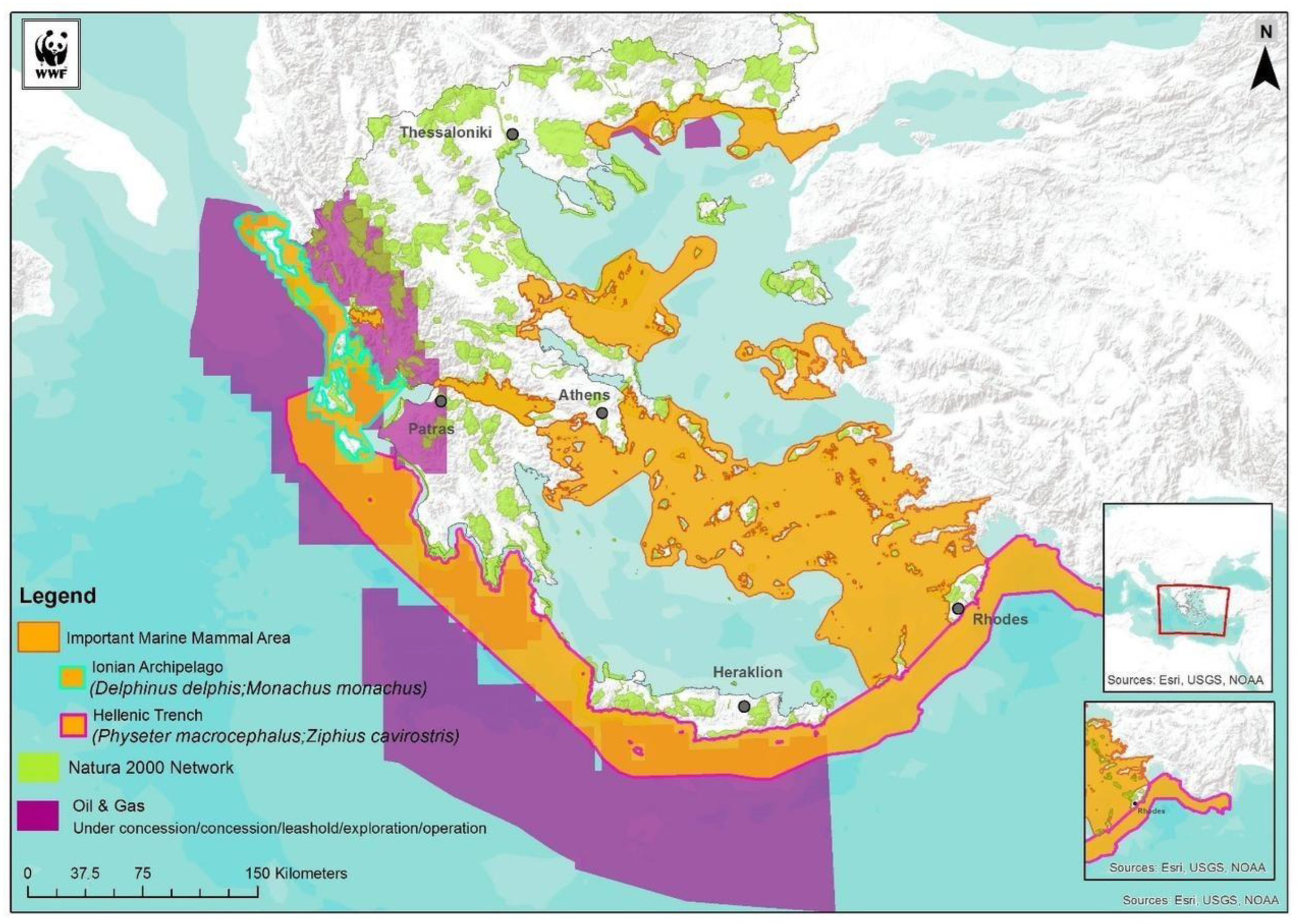
2.1. Ecological Concerns
2.1.1. The Hellenic Trench
2.1.2. The Ionian Archipelago
2.2. Important Marine Mammal Areas
2.3. Marine Spatial Planning
MSP and Integrated Coastal Zone Management
3. International Governance Framework for the Sea
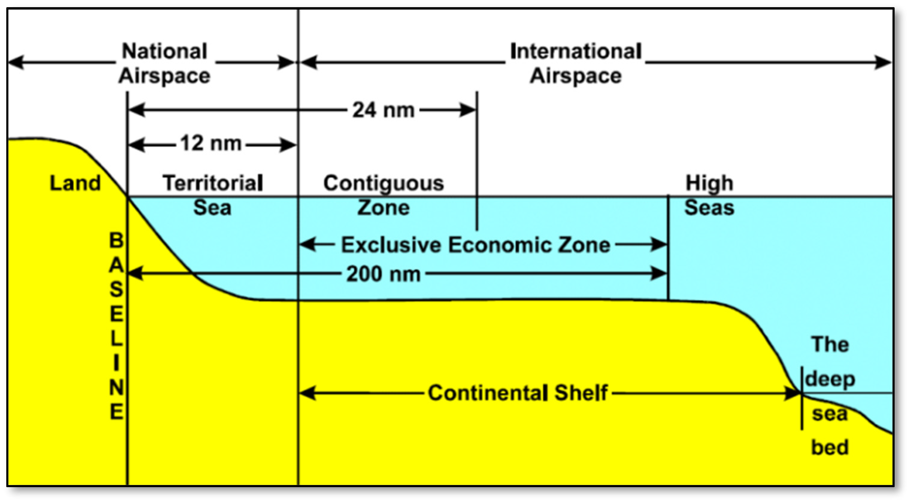
3.1. United Nations Convention for the Law of the Sea (UNCLOS)
3.2. Sea Zones in Accordance with UNCLOS Provisions
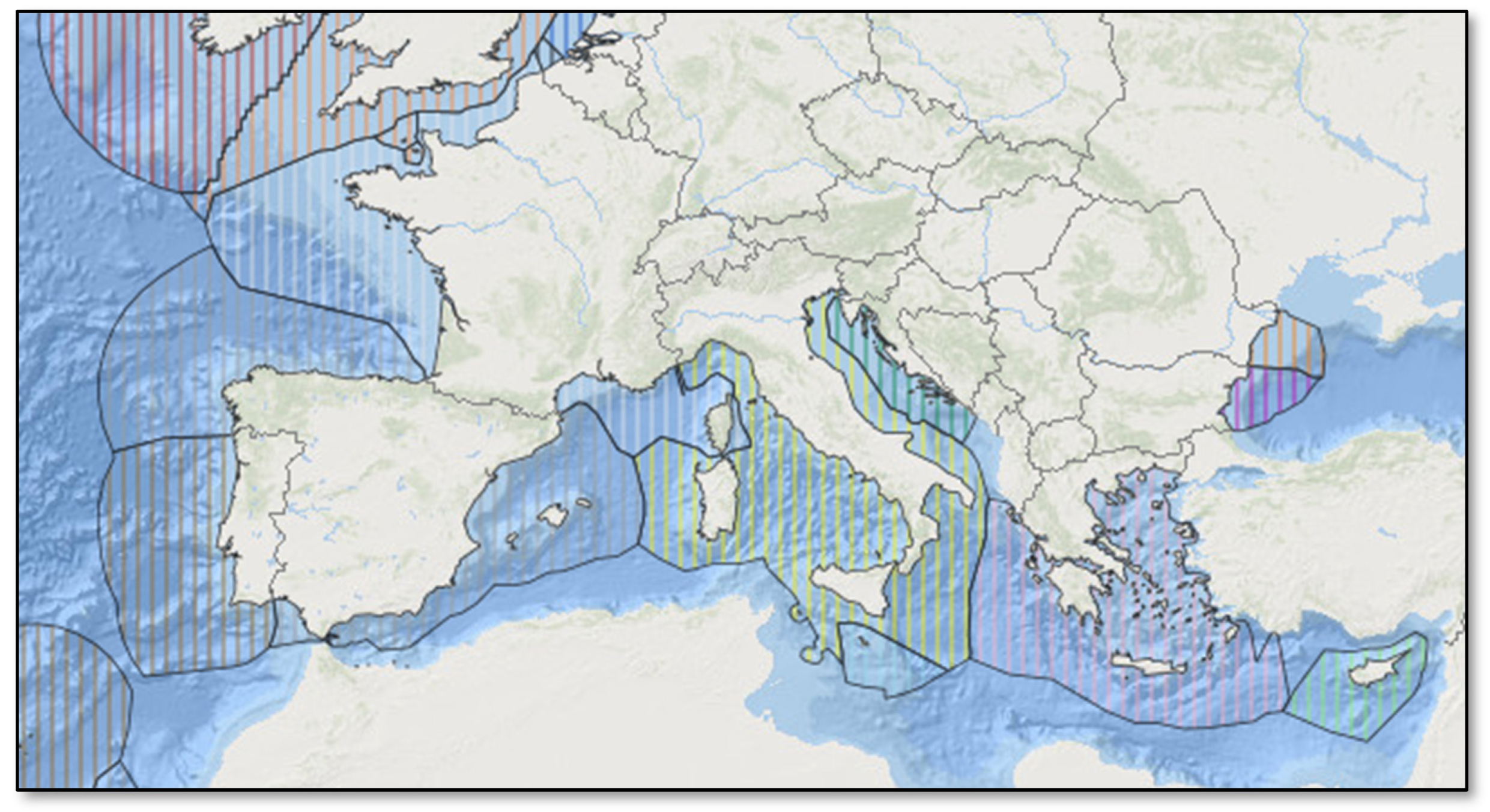
3.3. Delimitation of Maritime Zones
Maritime Zones in Eastern Mediterranean
3.4. The UNEP Regional Seas Programme
The Mediterranean Action Plan
4. European Governance Framework for the Sea
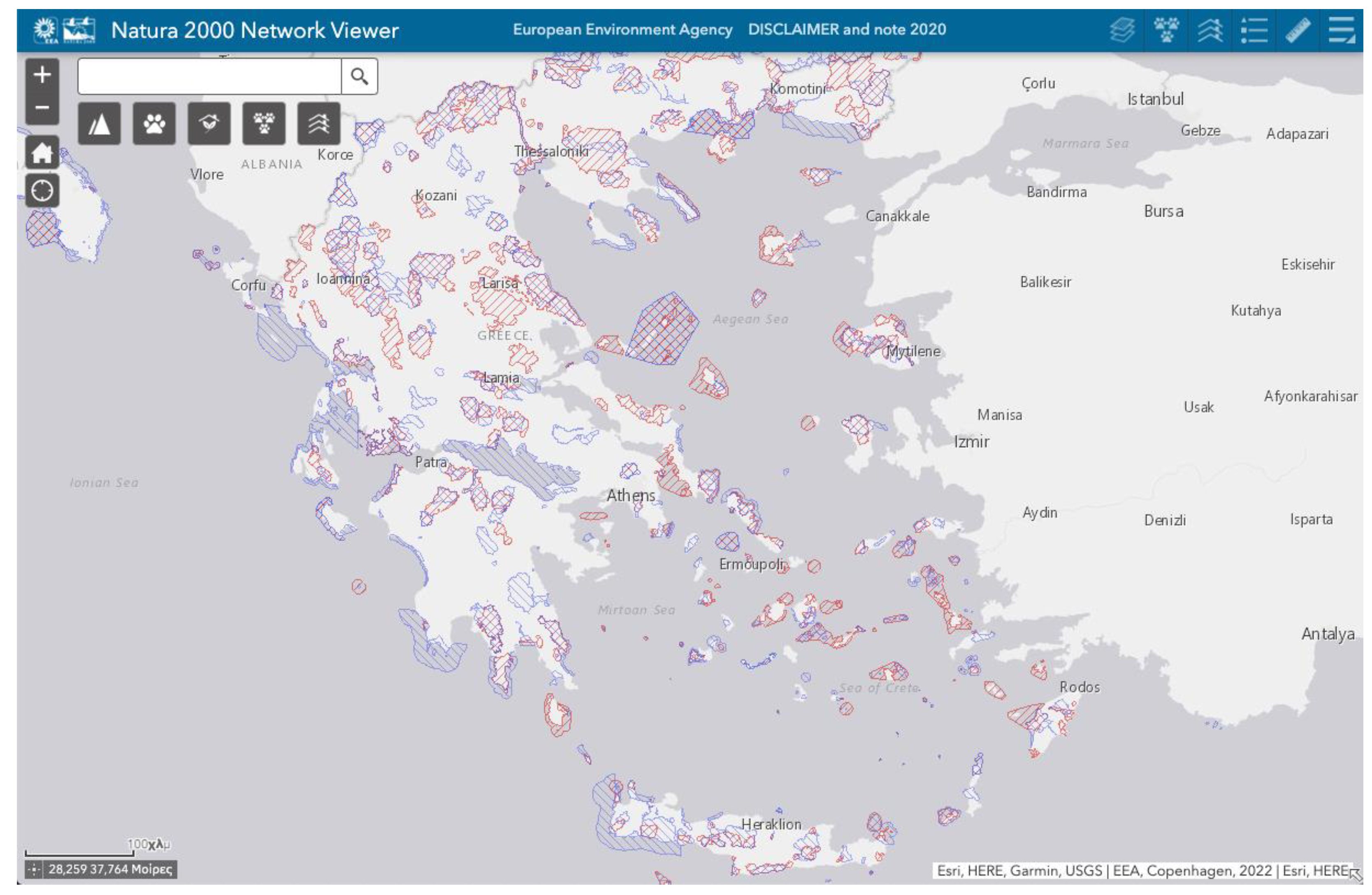
4.1. Directive on the Conservation of Natural Habitats
4.2. Integrated Maritime Policy
4.2.1. Blue Growth Strategy
- (a)
- Developing the marine sectors with the promise for long-term jobs creation and expansion.
- (b)
- Providing knowledge, regulatory stability, and confidence in the ocean economy.
- (c)
- Implementing sea basin policies to ensure states’ collaboration.
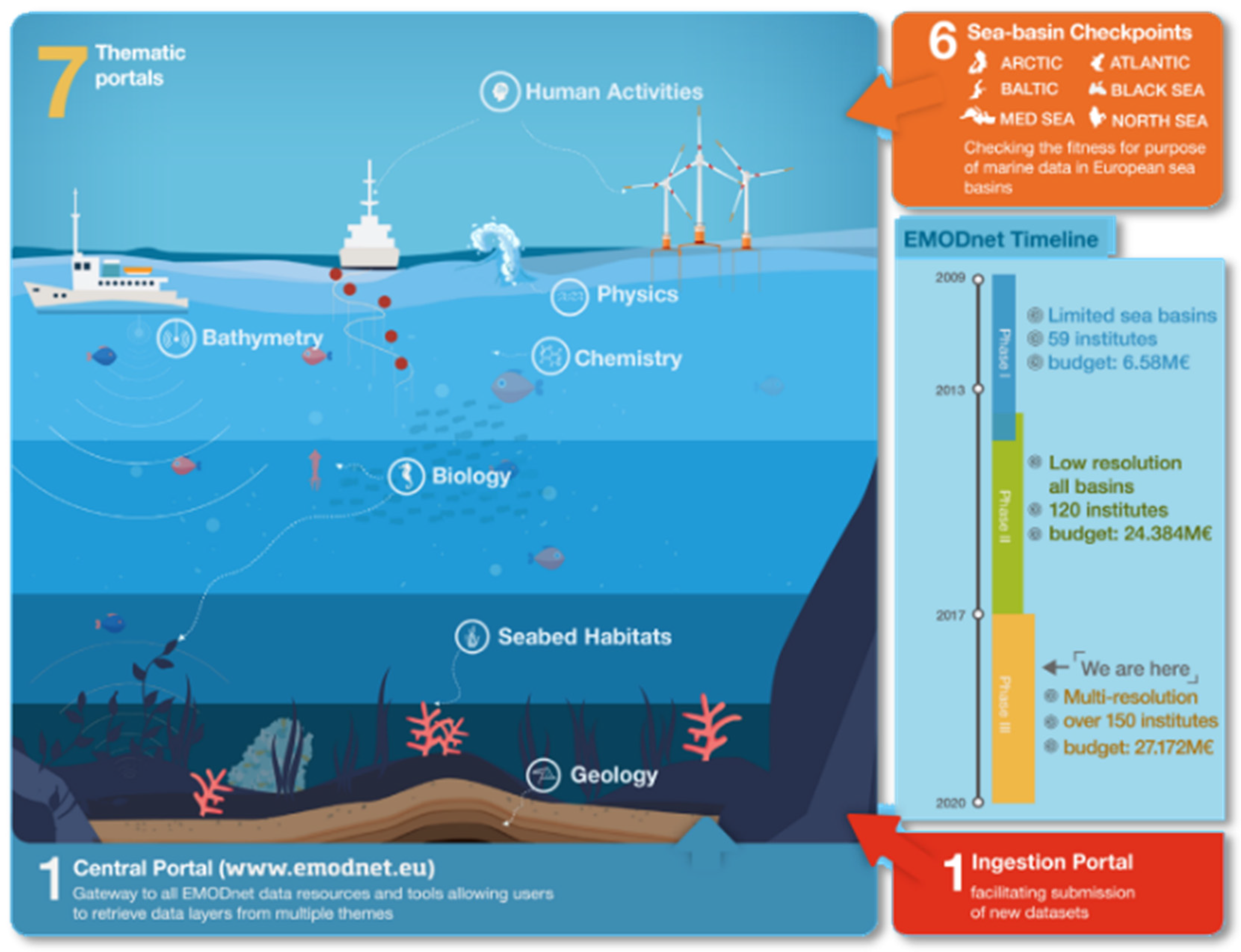
4.2.2. Data and Knowledge about the Sea
- Enhance efficiency in all operations that use marine data by minimizing data recollection and the expenses for gathering.
- Boost competitiveness and creativity in existing and emerging maritime industries.
- Decrease ambiguity in our understanding of the oceans and increase our ability to forecast.
4.3. Marine Spatial Planning Directive
- The rising interest for marine space for various marine activities, such as energy plants, oil and gas extraction, shipping, fishing, biodiversity conservation, tourism, and underwater cultural heritage, in conjunction with the numerous demands on coastal resources necessitate a holistic approach to planning and management of marine domain.
- Adopting an ecosystem-based approach will aid in the long-term development and expansion of marine and coastal economies and the responsible use of coastal and marine resources.
- To encourage the sustained coexisting of activities and, when applicable, the proper placement of complementary uses in the marine region, a framework is needed that typically includes the acceptance and execution by Member States of marine spatial planning outcomes in appropriate charts.
Environmental Impact Assessments
- Have a serious environmental impact, they are subject to Directive 2001/42/EU.
- Incorporate Natura 2000 sites and to prevent overlap, the environmental impact assessment shall be supplemented with the criteria of Article 6 of Directive 1992/43/ EU.
4.4. MSP Plans in Europe
4.4.1. Germany
- -
- Securing and enhancing maritime traffic.
- -
- Enhancing maritime business activities with integrated spatial organization and efficient use of space.
- -
- Encouraging the use of offshore wind energy in accordance with the federal government’s sustainability plan.
- -
- Long-term safeguarding and use of rotation mechanisms in case of problems and giving priority to specific uses.
- -
- Ensuring natural resources for tackling ecosystem disturbances and marine pollution.
- -
- Priority areas where one use (for instance, shipping, energy, etc.) takes precedence over all the other uses in the region.
- -
- Reserve areas in which one use is given particular attention to benchmarking with other spatial planning activities.
- -
- Marine protected areas where sustainable measures are applied to the marine environment.
4.4.2. United Kingdom
4.4.3. France
5. Marine Spatial Planning in Greece
5.1. MSP Law (4546/2018)—Marine Spatial Strategy
- -
- Article 5 provides for the procedure for the establishment and implementation of maritime spatial planning, which specifies that maritime spatial planning shall be completed as soon as possible and by 31 March 2021 at the latest and stipulates that the maritime spatial planning includes the national spatial planning strategy for sea space and the marine spatial plans.
- -
- Article 6 defines the structure of the marine spatial planning and specifies that the national spatial strategy for the marine area is part of the national spatial strategy of article 3 of Law 4447/2016.
- -
- Article 7 sets out the minimum requirements for maritime spatial planning, while Article 8 defines its content. Article 9 contains provisions for public consultation and public participation, and then Article 10 provides for issues related to the use and exchange of data.
- -
- Articles 11 and 12 then provide for co-operation with Member States and third countries, respectively, while Article 13 sets out the obligation to monitor marine spatial planning.
5.1.1. MSP Authority
- -
- In the Greek maritime and coastal areas, as well as in Europe, human activities, the effects of climate change, and natural disasters, as well as natural coastal transformations, can have serious economic, social, and environmental impacts.
- -
- Marine spatial planning (MSP) is the public process of analyzing and planning the distribution of human activities in marine areas to achieve economic, environmental, and social objectives.
- -
- Through the preparation of plans, the main purpose of maritime spatial planning is to promote sustainable development and determine the utilization of marine space for different uses, as well as the management of their uses and conflicts.
- -
- It is particularly emphasized that another approach that forms part of the Integrated Maritime Policy of the European Union and is directly linked to MSP is the Integrated Coastal Zone Management (ICZM).
- -
- The seamless link between marine and coastal areas requires the coordination and integration of maritime spatial plans and integrated coastal zone management strategies, in order to ensure the sustainable use of maritime space and the management of coastal zones, taking into consideration social, economic, and environmental factors.
- -
- Cooperation between Member States, as well as with third countries, in the maritime areas concerned, in accordance with international law and conventions, in particular the provisions of the UNCLOS Convention, is essential when designing and implementing maritime spatial planning.
5.1.2. Planning for Coastal Land and for the Sea
5.1.3. Planning on Multiple Scales
6. Smart Marine Ecosystem-Based Planning (SMEP)
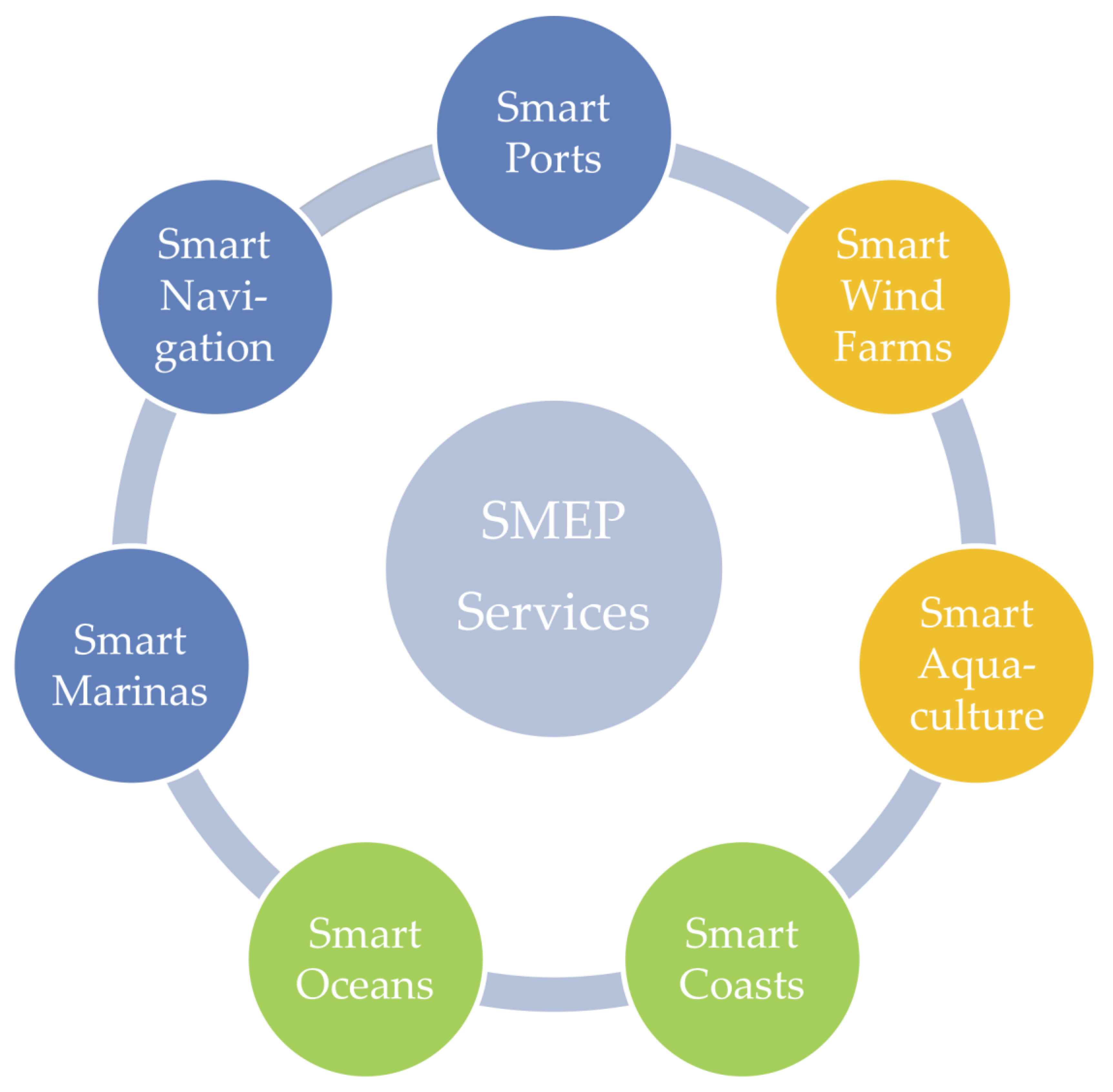
6.1. Smart Marine Ecosystem
Smart Marine Ecosystem-Based Planning Strategy
- -
- Improved aquaculture and coastal waste recycling infrastructure.
- -
- More efficient methods of protecting and utilizing maritime space.
- -
- Increased marine life by using more sustainable integrated solutions.
- -
- Smarter maritime transportation networks.
- -
- Solving policy issues in sectors such as fisheries, marine, energy, and information and communication technology.
6.2. Smart Hydrospatial Data Services
6.2.1. Smart Ports
- -
- Pooled ability for increasing capacity utilization and lowering costs.
- -
- Data science, which is connected to digitization, for operational optimization.
- -
- Intelligent vessels for automated and improved processes, as well as performance management.
- -
- Automation to improve port operational effectiveness.
6.2.2. Smart Offshore Wind Farms
6.2.3. Smart Aquaculture
6.2.4. Smart Coasts
6.2.5. Smart Oceans
6.2.6. Smart Marinas
6.2.7. Smart Navigation
- -
- Sea traffic management, resulting optimization in vessels traffic flow.
- -
- Knowledge of the maritime domain, which allows vessels to anticipate potentially hazardous circumstances.
- -
- Proactive maritime safety management, with a focus on avoiding identified dangers.
- -
- Remote monitoring, allowing ship systems to be evaluated.
- -
- Telematics service, which provides navigational safety information in a streamlined manner.
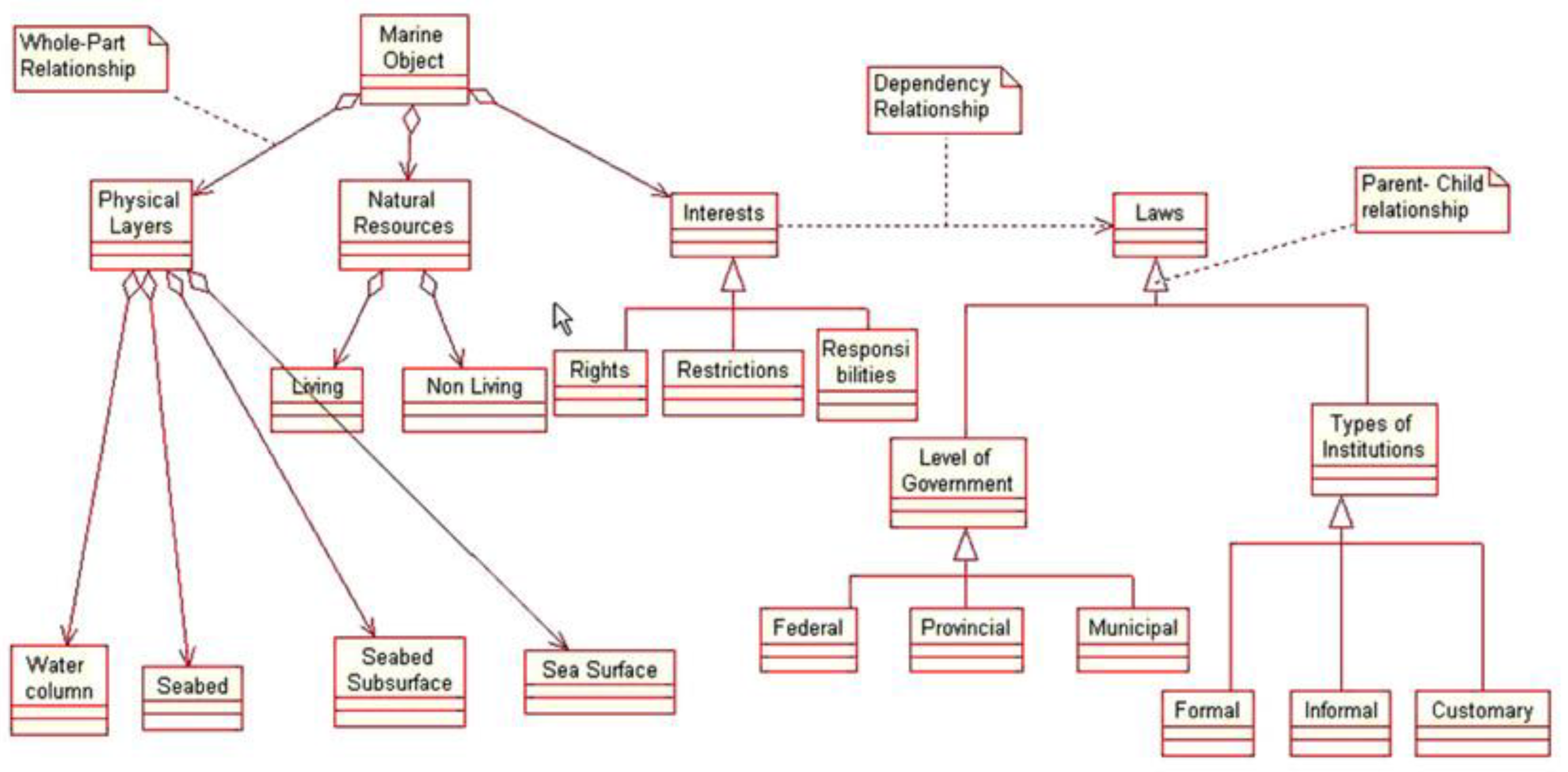
7. Implementing the Marine Cadastre
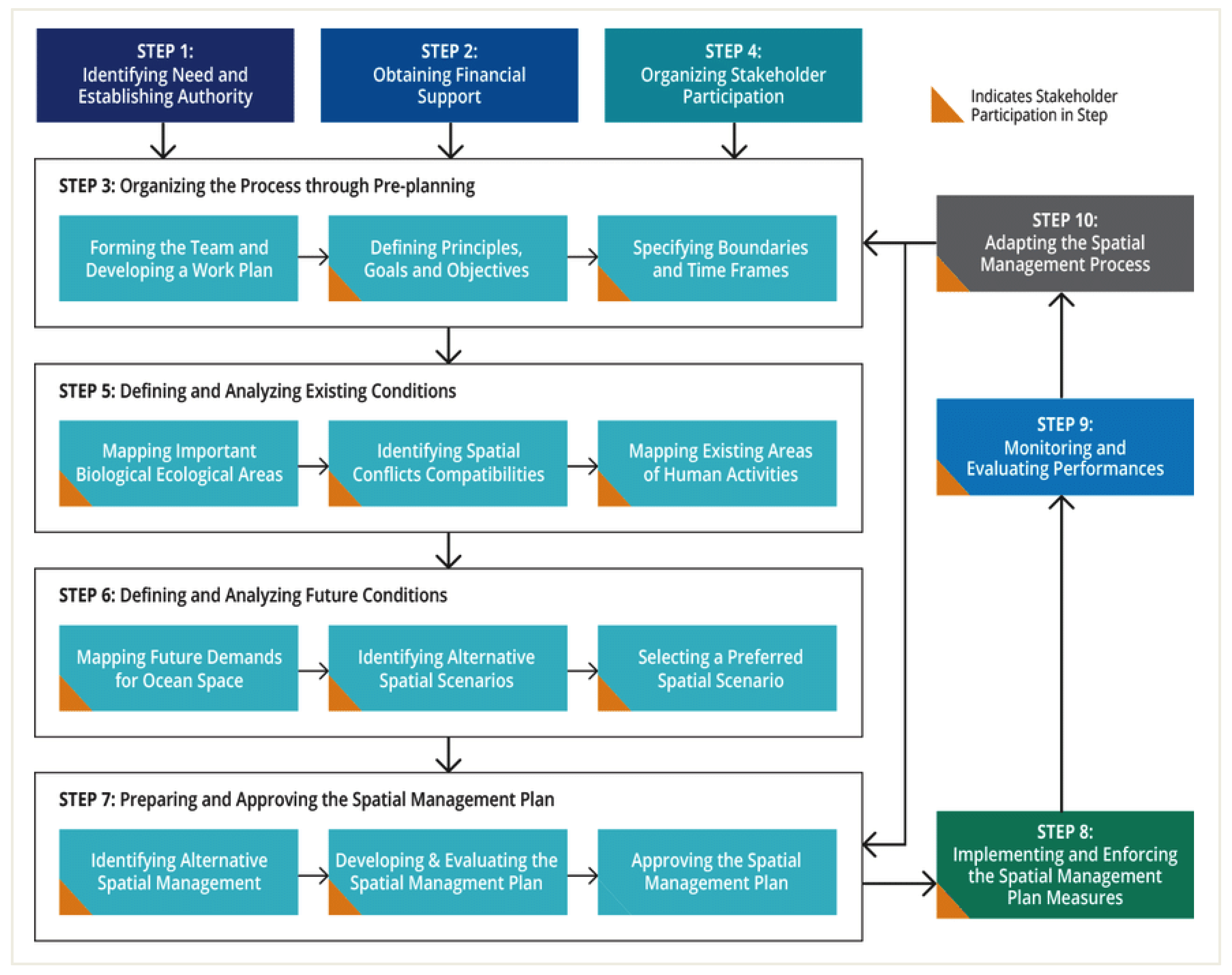
7.1. MSP Implementation Guide
- -
- In step 3, related to pre-planning and establishing planning limitations to organize the process.
- -
- In step 5, for defining and analyzing existing conditions by mapping areas of human activities as well as important ecological areas and identifying spatial conflicts.
- -
- In step 6, which is about defining and analyzing future conditions by mapping new demands for marine space and identifying alternative spatial scenarios.
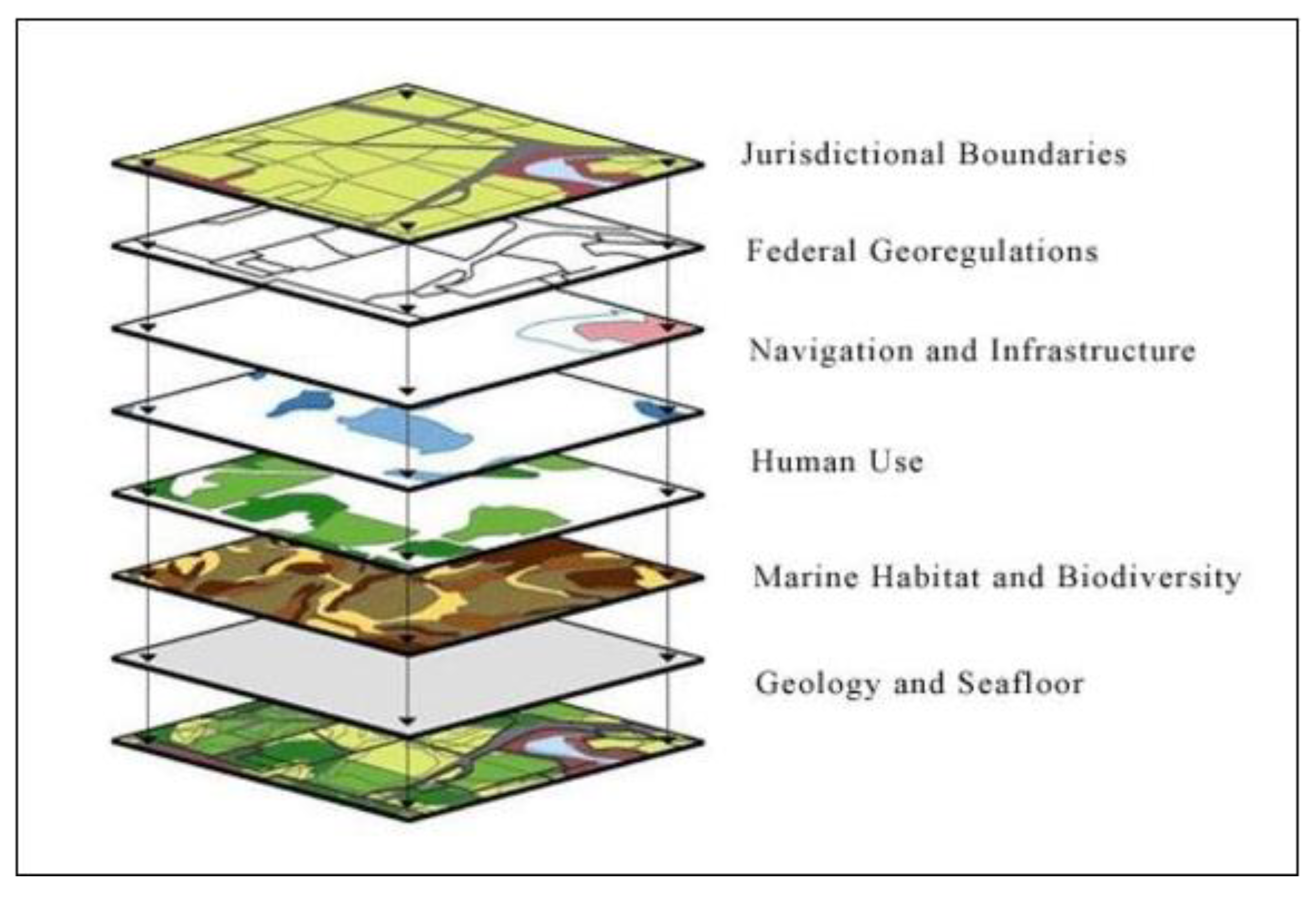
7.1.1. Multipurpose Marine Cadastre
7.1.2. MSDI Establishment
7.1.3. MSDI Enablers
7.1.4. S-121 Maritime Limits and Boundaries
- The party component which defines the different actors and their role associated with an object.
- The geospatial component that specifies the object’s location and type.
- The legal component, which supports the definition of the related jurisdictions and rights in relation to the object.
- Administrative or geographical sources such as treaties, legal papers, and maps.
7.1.5. Land Administration Alignment
7.1.6. S-122 Marine Protected Areas (MPAs)
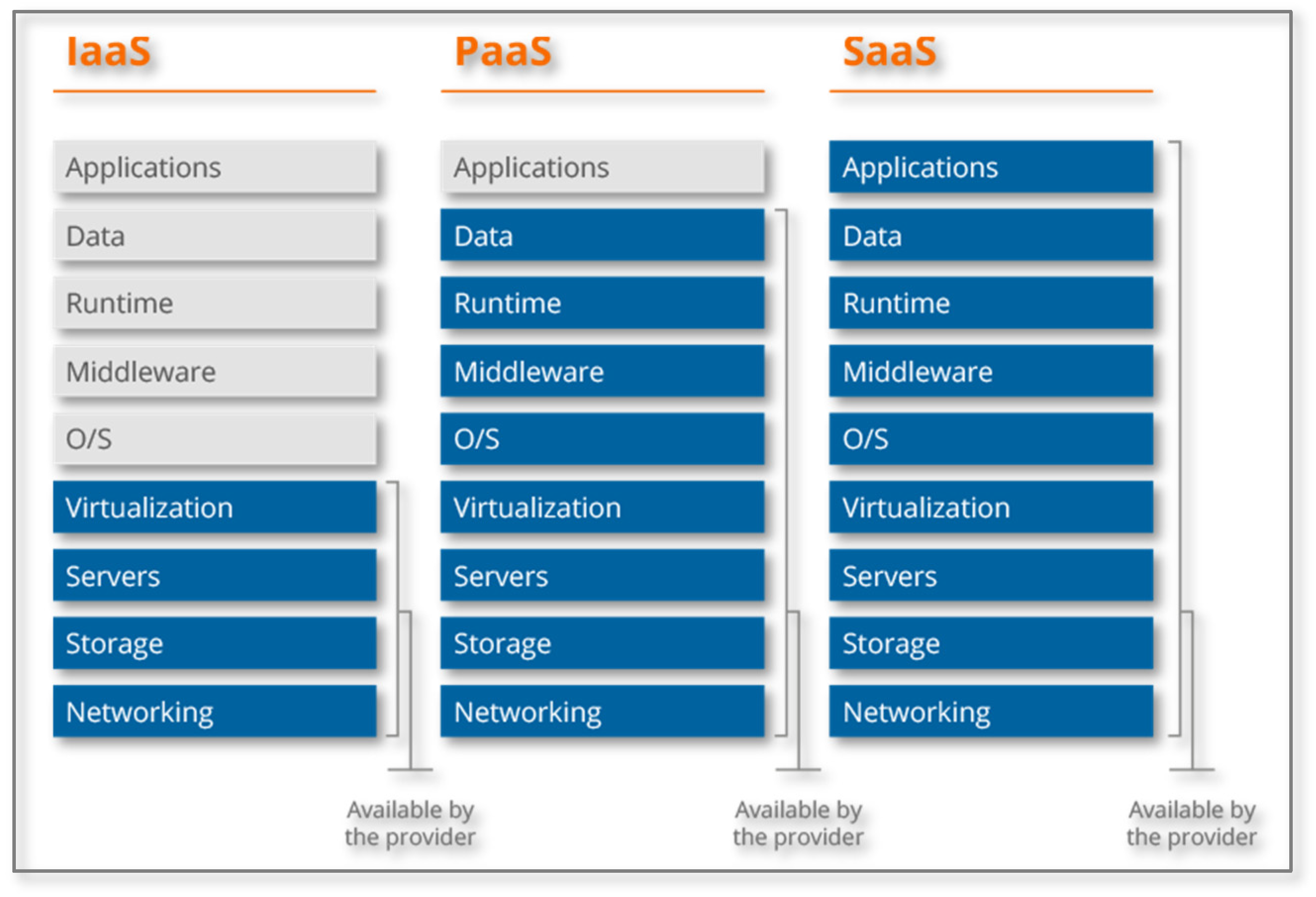
7.2. MSDI Cloud Infrastructure
8. Discussion
- -
- Multi-objective and integrated, embracing all main economic sectors, having economic, social, and environmental targets.
- -
- Strategic and forward-thinking, exploring different methods of achieving a vision.
- -
- Ongoing and adaptable, with a focus on performance assessment and acquiring knowledge upon doing.
- -
- Participatory, building a diverse stakeholders base to guarantee long-term management commitment.
- -
- Ecosystem-based, with an emphasis on long-term environmental resource preservation.
- -
- Geographically focused, with an emphasis on marine zones that people could understand, connect to, and be concerned about.
9. Conclusions
Author Contributions
Funding
Conflicts of Interest
References
- United States Defense Mapping Agency. Coastal Length Data Are Based on the World Vector Shoreline. Figures Were Calculated by Pruett, L. and Cimino, J., Unpublished Data, Global Maritime Boundaries Database (GMBD), Veridian—MRJ Technology Solutions, (Fairfax, Virginia, January 2000). 1989. Available online: https://web.archive.org/web/20120419075053/http://earthtrends.wri.org/text/coastal-marine/variable-61.html (accessed on 8 May 2022).
- Nakos, Β.; Filippakopoulou, V.; Stamou, L. The impact of line generalization on the length of Greek coastlines. In Proceedings of the 7th National Cartographic Conference, Hellenic Cartographic Society, Mytilini, Greece, 23–26 October 2002; pp. 279–290. (In Greek). [Google Scholar]
- Hellenic Federation of Enterprises (SEV). Special Expertise Report on Adaptation of Entrepreneurship Policies and Processes from the Establishment of a Specific Institutional Framework for Marine Spatial Planning, Athens, October 2018. Available online: https://www.sev.org.gr/Uploads/Documents/52131/MELETI_final.pdf (accessed on 8 May 2022). (In Greek).
- Lawrence, D.; Kenchington, R.; Woodley, S. The Great Barrier Reef; Melbourne University Press: Melbourne, Australia, 2002. [Google Scholar]
- Greece Urged to Protect Hellenic Trench from Seismic Blasts. Available online: https://www.nrdc.org/experts/francine-kershaw/greece-urged-protect-hellenic-trench-seismic-blasts (accessed on 8 May 2022).
- Frantzis, A.; Leaper, R.; Alexiadou, P.; Prospathopoulos, A.; Lekkas, D. Shipping routes through core habitat of endangered sperm whales along the Hellenic Trench, Greece: Can we reduce collision risks? PLoS ONE 2019, 14, e0212016. [Google Scholar] [CrossRef] [PubMed] [Green Version]
- Ionian Archipelago, Important Marine Mammal Area. Available online: https://www.marinemammalhabitat.org/portfolio-item/ionian-archipelago/ (accessed on 8 May 2022).
- Bradshaw, C.J.A.; Greenhill, L.; Yates, K.L. The future of marine spatial planning. In Offshore Energy and Marine Spatial Planning; Routledge: Abingdon, UK, 2018; pp. 284–293. [Google Scholar] [CrossRef]
- European Commission. Communication from the Commission to the Council and the European Parliament on Integrated Coastal Zone Management: A strategy for Europe; COM(2000) 547; Publications Office of the European Union: Brussels, Belgium, 2000. [Google Scholar]
- Kristina, V.; Pille, M. Assessment of Application of Baltic Sea Common Regional Maritime Spatial Planning Framework. Pan Baltic Scope Project Report Commissioned by VASAB. 2019. Available online: https://vasab.org/documents/msp-and-iczm/ (accessed on 8 May 2022).
- HELCOM-VASAB MSP Working Group. Baltic Sea Broad-Scale Maritime Spatial Planning Principles. Available online: https://helcom.fi/media/documents/HELCOM-VASAB-MSP-Principles.pdf (accessed on 11 July 2021).
- Ventura, A.M.F. Environmental Jurisdiction in the Law of the Sea; Springer International Publishing: Berlin/Heidelberg, Germany, 2020. [Google Scholar] [CrossRef]
- Kastrisios, C.; Tsoulos, L. Maritime zones delimitation—Problems and solutions. In Proceedings of the International Cartographic Association Conference, Washington, DC, USA, 2–7 July 2017; Volume 1, pp. 1–7. [Google Scholar] [CrossRef] [Green Version]
- Athanasiou, K.; Sutherland, M.; Kastrisios, C.; Tsoulos, L.; Griffith-Charles, C.; Davis, D.; Dimopoulou, E. Toward the Development of a Marine Administration System Based on International Standards. ISPRS Int. J. Geo-Inf. 2017, 6, 194. [Google Scholar] [CrossRef] [Green Version]
- European Commission. An Integrated Maritime Policy for the European Union; Commission Communication COM(2007) 575; Publications Office of the European Union: Brussels, Belgium, 2007. [Google Scholar]
- European Commission. Blue Growth, Opportunities for Marine and Maritime Sustainable Growth; Commission Communication COM(2010) 494; Publications Office of the European Union: Brussels, Belgium, 2012. [Google Scholar]
- European Commission. Europe 2020. A Strategy for Smart, Sustainable and Inclusive Growth; COM (2010) 2020 Final; European Commission: Brussels, Belgium, 3 March 2010. [Google Scholar]
- European Commission. Directorate-General for Maritime Affairs and Fisheries, Marine Knowledge 2020: From Seabed Mapping to Ocean Forecasting: Green Paper; Publications Office of the European Union: Brussels, Belgium, 2012; Available online: https://data.europa.eu/doi/10.2771/4154 (accessed on 8 May 2022).
- Shepherd, I. European efforts to make marine data more accessible. Ethics Sci. Environ. Politics 2018, 18, 75–81. [Google Scholar] [CrossRef]
- European Parliament and Council Directive 2014/89/EU of the European Parliament and of the Council of 23 July 2014 Establishing a Framework for Maritime Spatial Planning. 2014. Available online: http://data.europa.eu/eli/dir/2014/89/oj (accessed on 8 May 2022).
- Incorporating the MSP EU Directive in the Greek Law (Greek Text). Available online: https://www.alikakou.gr/gr/el/articles/thalassios-xorotaksikos-sxediasmos-i-ensomatosi-tis-odigias-2014-89ee-me-to-to-n-45462018 (accessed on 8 May 2022).
- Ramieri, E.; Bocci, M.; Markovic, M. Linking Integrated Coastal Zone Management to Maritime Spatial Planning: The Mediterranean Experience. In Maritime Spatial Planning; Springer International Publishing: Berlin/Heidelberg, Germany, 2019; pp. 271–294. [Google Scholar] [CrossRef] [Green Version]
- Papageorgiou, M. Marine Spatial Planning and Marine Uses: Conceptual and Theoretical Issues. J. Aeixoros 2016, 23, 41–63. [Google Scholar]
- Moraitakis, G. Smart Marine Ecosystem, Safety4Sea Conference, Presentation of Wärtsilä Greece. 2019. Available online: https://safety4sea.com/cm-smart-marine-ecosystem/ (accessed on 8 May 2022).
- IPCC. Summary for Policymakers. In Climate Change 2021: The Physical Science Basis; Contribution of Working Group I to the Sixth Assessment Report of the Intergovernmental Panel on Climate Change; IPCC: Geneva, Switzerland, 2021; Available online: https://www.ipcc.ch/report/ar6/wg1/ (accessed on 8 May 2022).
- Contarinis, S.; Pallikaris, A.; Nakos, B. The Value of Marine Spatial Open Data Infrastructures—Potentials of IHO S-100 Standard tο Become the Universal Marine Data Model. J. Mar. Sci. Eng. 2020, 8, 564. [Google Scholar] [CrossRef]
- Molavi, A.; Lim, G.J.; Race, B. A framework for building a smart port and smart port index. Int. J. Sustain. Transp. 2019, 14, 686–700. [Google Scholar] [CrossRef]
- Katikas, L.; Kontos, T.D. Suitability Assessment for Offshore Wind Farm Siting Using Exclusion Criteria and Spatial Economic Models: The Case of North and Central Aegean Sea. In Proceedings of the Environmental Science, Policy & Management, Lesvos Island, Greece, 1–3 June 2018. [Google Scholar] [CrossRef]
- Yang, Y.; Yang, X.; Tan, J.; Chen, L.; Zheng, M.; Wang, S. The Scheme Design of Smart Offshore Wind Farm. In Proceedings of the 2019 Prognostics and System Health Management Conference (PHM-Qingdao), Qingdao, China, 25–27 October 2019; IEEE: Piscataway, NJ, USA, 2019; pp. 1–6. [Google Scholar]
- Dzulqornain, M.I.; Rasyid MU, H.A.; Sukaridhoto, S. Design and Development of Smart Aquaculture System Based on IFTTT Model and Cloud Integration. MATEC Web Conf. 2018, 164, 01030. [Google Scholar] [CrossRef] [Green Version]
- Smart Coasts: Measuring Water Quality at Welsh and Irish Beaches. Available online: https://ec.europa.eu/regional_policy/it/projects/united-kingdom/smart-coasts-measuring-water-quality-at-welsh-and-irish-beaches (accessed on 8 May 2022).
- Scardino, G.; Sabatier, F.; Scicchitano, G.; Piscitelli, A.; Milella, M.; Vecchio, A.; Anzidei, M.; Mastronuzzi, G. Sea-Level Rise and Shoreline Changes Along an Open Sandy Coast: Case Study of Gulf of Taranto, Italy. Water 2020, 12, 1414. [Google Scholar] [CrossRef]
- Smart Ocean. Available online: https://goexplorer.org/smart-ocean/ (accessed on 8 May 2022).
- Platform for the Yachting Industry, Interconnecting Marinas and Yachters. Available online: https://www.fiware.org/success-stories/sammy/ (accessed on 8 May 2022).
- Smart Marina Project. Available online: https://www.smartmarina.eu (accessed on 8 May 2022).
- SMART-Navigation Project. Available online: https://www.iala-aism.org/technical/e-nav-testbeds/smart-navigation-project/ (accessed on 8 May 2022).
- Ehler, C.; Douvere, F. Visions for a Sea Change: Report of the First International Workshop on Marine Spatial Planning; Intergovernmental Oceanographic Commission and the Man and the Biosphere Programme UNESCO Headquarters: Paris, France, 2006. [Google Scholar] [CrossRef]
- Principles for a Seabed Cadastre. OSG Technical Report 9, Office of the Surveyor-General. New Zealand, 1999. Available online: https://docplayer.net/159576845-Principles-for-a-seabed-cadastre-osg-technical-report-9-office-of-the-surveyor-general.html (accessed on 8 May 2022).
- Multipurpose Marine Cadastre. NOAA, Bureau of Ocean Energy Management. 2012. Available online: http://dusk.geo.orst.edu/ICAN_EEA/Members/NOAA_MMC.pdf (accessed on 8 May 2022).
- Contarinis, S.; Nakos, B.; Pallikaris, A. Marine Spatial Data Infrastructure in Greece—Challenges and Opportunities. Nausivios Chora 2018, 7, E3–E30. Available online: http://nausivios.hna.gr/docs/2018E1.pdf (accessed on 8 May 2022).
- International Hydrographic Organisation (IHO). Spatial Data Infrastructures “The Marine Dimension”; Guidance for Hydrographic Offices, IHO Publication C-17—Edition 2.0.0; International Hydrographic Bureau: Monte-Carlo, Monaco, 2017. [Google Scholar]
- Contarinis, S.; Kastrisios, C. Marine Spatial Data Infrastructure. In The Geographic Information Science & Technology Body of Knowledge (1st Quarter 2022 Edition); Wilson, J.P., Ed.; University Consortium for Geographic Information Science (UCGIS): Ithaca, NY, USA, 2022. [Google Scholar] [CrossRef]
- FIG. Administering Marine Spaces: International Issues; FIG Report; The International Federation of Surveyors (FIG): Frederiksberg, Denmark, 2006; ISBN 87-90907-55-8. [Google Scholar]
- Fowler, C.; Smith, B.F.; Stein, D. Building a Marine Spatial Data Infrastructure to Support Marine Spatial Planning in US Waters; National Oceanic and Atmospheric Administration (NOAA), Coastal Services Center: Charleston, SC, USA, 2010; 6p.
- Sun, J.; Mi, S.; Olsson, P.-O.; Paulsson, J.; Harrie, L. Utilizing BIM and GIS for Representation and Visualization of 3D Cadastre. ISPRS Int. J. Geo-Inf. 2019, 8, 503. [Google Scholar] [CrossRef] [Green Version]
- Balla, E.; Wouters, R. Marine Cadastre in Europe: State of play (NR 355). In World Bank Conference on Land and Poverty; The World Bank: Washington, DC, USA, 2017. [Google Scholar]
- IHO. S-100 Universal Hydrographic Data Model (Edition 4.0.0, December 2018). Available online: https://iho.int/uploads/user/pubs/standards/s-100/S-100_Ed%204.0.0_Clean_17122018.pdf (accessed on 8 May 2022).
- ΙHO. S-121 Maritime Limits and Boundaries Product Specification v1.0.0. 2019. Available online: https://registry.iho.int/productspec/view.do?idx=177&product_ID=S-121 (accessed on 8 May 2022).
- Ng’ang’a, S.M.; Sutherland, M.; Cockburn, S.; Nichols, S. Toward a 3D marine Cadastre in support of good ocean governance: A review of the technical framework requirements. Comput. Environ. Urban Syst. J. 2004, 28, 443–470. [Google Scholar] [CrossRef]
- IHO. S-122 Marine Protected Areas Product Specification v1.0.0. 2019. Available online: https://registry.iho.int/productspec/view.do?idx=73&product_ID=S-122 (accessed on 8 May 2022).
- WWF. Two-Thirds of EU Countries Fail to Submit Plans for Sustainable Management of Their Seas on Time. 2021. Available online: https://www.wwf.eu/wwf_news/media_centre/?uNewsID=2717941 (accessed on 8 May 2022).
- Hellenic Republic. Greece 2.0 National Recovery and Resilience Plan. 2021. Available online: https://primeminister.gr/wp-content/uploads/2021/03/Greece-2_0-April-2021.pdf (accessed on 8 May 2022).
- Douvere, F. The importance of marine spatial planning in advancing ecosystem-based sea use management. Mar. Policy 2008, 32, 762–771. [Google Scholar] [CrossRef]
- WWF. Position Paper: Achieving Ecosystem-Based Marine Spatial Plans. 2020. Available online: https://wwfeu.awsassets.panda.org/downloads/wwf_position_paper_ecosystem_based_approach_in_msp___feb2020.pdf (accessed on 8 May 2022).


| Code | MSP Service | SMART-Navigation Services |
|---|---|---|
| MSP1 | VTS Information Service (IS) | SV1 → Navigation Monitoring & Assistance Service (NAMAS) SV2 → Ship-borne System Monitoring Service (SBSMS) SV3 → Safe & Optimal Route Planning Service (SORPS) |
| MSP2 | Navigational Assistance Service (NAS) | |
| MSP3 | Traffic Organization Service (TOS) | |
| MSP4 | Local Port Service | |
| MSP5 | Maritime Safety Information Service (MSI) | SV6 → Maritime Environment and Safety Information Service (MESIS) |
| MSP6 | Pilotage service | SV5 → Pilot & Tugs Assistance Service (PITAS) |
| MSP7 | Tug Service | |
| MSP8 | Vessel Shore Reporting | |
| MSP9 | Telemedical Assistance Service (TMAS) | |
| MSP10 | Maritime Assistance Service (MAS) | SV1 → Navigation Monitoring & Assistance Service (NAMAS) SV2 → Ship-borne System Monitoring Service (SBSMS) |
| MSP11 | Nautical Chart Service | |
| MSP12 | Nautical Publications Service | |
| MSP13 | Ice Navigation Service | |
| MSP14 | Meteorological Information Service | SV6 → Maritime Environment and Safety Information Service (MESIS) |
| MSP15 | Real-time Hydrographic and Environmental Information Service | |
| MSP16 | Search and Rescue Service | SV1 → Navigation Monitoring & Assistance Service (NAMAS) SV2 → Ship-borne System Monitoring Service (SBSMS) |
Publisher’s Note: MDPI stays neutral with regard to jurisdictional claims in published maps and institutional affiliations. |
© 2022 by the authors. Licensee MDPI, Basel, Switzerland. This article is an open access article distributed under the terms and conditions of the Creative Commons Attribution (CC BY) license (https://creativecommons.org/licenses/by/4.0/).
Share and Cite
Contarinis, S.; Nakos, B.; Pallikaris, A. Introducing Smart Marine Ecosystem-Based Planning (SMEP)—How SMEP Can Drive Marine Spatial Planning Strategy and Its Implementation in Greece. Geomatics 2022, 2, 197-220. https://doi.org/10.3390/geomatics2020012
Contarinis S, Nakos B, Pallikaris A. Introducing Smart Marine Ecosystem-Based Planning (SMEP)—How SMEP Can Drive Marine Spatial Planning Strategy and Its Implementation in Greece. Geomatics. 2022; 2(2):197-220. https://doi.org/10.3390/geomatics2020012
Chicago/Turabian StyleContarinis, Stilianos, Byron Nakos, and Athanasios Pallikaris. 2022. "Introducing Smart Marine Ecosystem-Based Planning (SMEP)—How SMEP Can Drive Marine Spatial Planning Strategy and Its Implementation in Greece" Geomatics 2, no. 2: 197-220. https://doi.org/10.3390/geomatics2020012
APA StyleContarinis, S., Nakos, B., & Pallikaris, A. (2022). Introducing Smart Marine Ecosystem-Based Planning (SMEP)—How SMEP Can Drive Marine Spatial Planning Strategy and Its Implementation in Greece. Geomatics, 2(2), 197-220. https://doi.org/10.3390/geomatics2020012