Article

Identifying and Mapping Prospective Koala Habitat on Woppa (Great Keppel Island), Queensland, to Explore Future Conservation Opportunities

1
School of Health, Medical and Applied Sciences, CQUniversity, Rockhampton North, QLD 4701, Australia
2
Koala Research-CQ, CQUniversity, Rockhampton North, QLD 4701, Australia
3
Capricorn Conservation Council, Wandal, QLD 4700, Australia
4
School of Education and the Arts, CQUniversity, Rockhampton North, QLD 4701, Australia
*
Author to whom correspondence should be addressed.
Conservation 2025, 5(4), 72; https://doi.org/10.3390/conservation5040072
Submission received: 16 September 2025 / Revised: 7 November 2025 / Accepted: 19 November 2025 / Published: 26 November 2025

Abstract

This study assessed the suitability of Woppa (Great Keppel Island), Queensland, as potential koala (Phascolarctos cinereus) habitat by combining existing koala-habitat ranking datasets with satellite-derived vegetation-health indices to inform conservation planning. This exploratory analysis establishes a spatial baseline to guide future ecological surveys, cultural consultation, and restoration planning on Woppa. Analysis of the Koala Habitat Ranking (NESP) and Regional Ecosystems (RE) layers indicated that only 2.7% of the island’s vegetation is classified as high-quality koala habitat. Satellite-derived indices (NDVI and LAI) were used to evaluate the vegetation condition of these and other vegetated areas across wet and dry seasons; some high-ranked patches displayed comparatively greater resilience to seasonal stress; however, the remote-sensing data did not confirm the presence or abundance of key Eucalyptus species. Given the small extent of high-ranked habitat and projected climate stressors, the study does not recommend translocation. Instead, it emphasises the need for targeted ground-truthing to verify tree species and habitat structure, monitoring of vegetation health, habitat restoration where feasible, and co-designed decision-making with the Woppaburra People, including assessments of carrying capacity, genetic viability, and disease risk, before any reintroduction is contemplated.

Graphical Abstract

1. Introduction

Koalas (Phascolarctos cinereus) have experienced severe population declines across their entire range since European colonisation due to widespread land clearing, disease, vehicle strikes, and extreme climate events [1]. In response to these declines and following the devastating effects of the Black Summer fires, koalas were listed as an endangered species in 2022 under the Environmental Protection and Biodiversity Act 1999 and the Environmental Protection and Biodiversity Act 1999 [1]. Earlier conservation efforts in response to the declining population from hunting in the early 1900s included translocating individuals to offshore islands and finding offshore refugia to protect isolated populations [2].
Some of these island populations, such as those on Magnetic Island and St Bees Island, have persisted and grown [2], while others elsewhere in Australia have failed due to ecological limitations, natural disasters, and mismanagement [3]. As koala habitat on the mainland continues to be fragmented anthropogenically and connectivity declines, populations are becoming increasingly isolated in “island-like” pockets of remnant bushland, which is evident from the lack of genetic diversity shown across different populations found around the heavily urbanised Southeast Queensland [3,4]. If such trends continue, establishing new habitats may become critical for long-term conservation, and lack of genetic diversity will be a problem faced on the mainland, as seen in island populations.
Koalas rely on a hierarchy of ‘primary’, ‘secondary’, and ‘supplementary’ food trees within their home ranges, with the density of primary and secondary eucalypts primarily determining habitat quality [5,6]. Larger trees are generally preferred for both food and shelter, although smaller trees with dense canopies are also important for thermal cover [6,7]. Assessing the presence, condition, and connectivity of such vegetation is a vital precursor to any reintroduction initiative.
Habitat mapping systems have been developed to classify habitat quality based on the proportion of primary and secondary food tree species within mapped Regional Ecosystem (RE) units [5]. While these tools have informed local and regional conservation planning, recent work has highlighted significant limitations, including errors in food tree proportion estimates and reliance on koala records that may not capture low-density but persistent populations [8]. Additionally, caution should be taken for any decision-making based solely on these rankings and their derived maps due to the likelihood of a floristic mix at any one location, which could see tree communities incorrectly ranked within a bioregion [9].
Satellite remote sensing has emerged as a valuable tool for evaluating habitat quality, enabling researchers to assess vegetation health, structure, and stressors across broad spatial and temporal scales [10,11]. Remotely sensed biophysical indicators, such as the Normalised Difference Vegetation Index (NDVI) and Leaf Area Index (LAI), provide insight into habitat integrity and ecosystem resilience [12]. These indicators can support conservation decision-making by identifying areas capable of supporting healthy koala populations, particularly in remote or difficult-to-access locations.
Woppa (Great Keppel Island) (Figure 1) is located approximately 12 km off Central Queensland’s (CQ) coast and, based on secondary historical sources, is reported to have once supported a naturally occurring koala population [2]. Woppa is part of the Keppel Isles, a group of islands within the Southern Great Barrier Reef World Heritage Area, all of which are continental islands, historically being part of the mainland only to separate 10,000 years ago with sea level rise [13]. There are reports of koalas being translocated to the island in the 1920s as part of early conservation efforts in response to the noticeable decline of the species [2]. Despite these efforts, along with the introduction of the Animal and Birds Act in 1920, no koalas have been sighted on the island for over 65 years [2]. Extensive habitat loss due to colonial settlement [14,15], along with the introduction of non-native animals [2,15] and illegal hunting [2], are believed to have contributed to the extinction of the island’s koala population.
There is increasing recognition of the broader cultural history of Woppa and the vital role of Indigenous land management in biodiversity conservation. Woppa is the traditional land and sea country of the Woppaburra People, who were forcibly removed from the island in 1902, after which extensive land clearing for pastoral and urban development further altered the landscape [16]. Today, the Woppaburra People are re-establishing their presence on the island through the Woppaburra TUMRA [17] and the return of land parcels under Native Title [18]. Collaborative management with the Woppaburra People is integral to the success of any conservation initiatives on Woppa, ensuring that cultural knowledge and stewardship guide ecological restoration and potential species reintroduction.
The aim of this research was to identify suitable koala habitat on Woppa using publicly available ecological data and satellite imagery. We hypothesised that although koalas are no longer present on the island, certain areas may still retain vegetation of sufficient quality to support future conservation initiatives. The results were mapped to assess the spatial extent and vegetation quality of these potential habitat areas. This exploratory spatial analysis represents an interim assessment, intended to establish a baseline for future ground-truthing, ecological validation, and ongoing cultural consultation with the Woppaburra People. Their knowledge and custodianship of Woppa are vital to any meaningful conservation effort. Embedding First Nations perspectives into planning and land management ensures that any future habitat restoration or species reintroduction initiatives are co-designed in alignment with cultural values and aspirations. Importantly, this assessment does not advocate immediate koala translocation; rather, it provides a framework for informed discussion and long-term collaboration, recognising that any future consideration of reintroduction would require decades of research, monitoring, and partnership with the Woppaburra People.

2. Materials and Methods

2.1. Habitat Ranking Assessment

This study used ArcGIS Pro 3.4.0 software to visualise and analyse spatial data layers relevant to koala habitat. Two primary datasets were used: (1) the Queensland Government Herbarium’s Regional Ecosystems (RE) layer and (2) the Koala Habitat Ranking Assessment layer developed by the National Environmental Science Programme (NESP) [19]. The latter incorporates koala records and tree species preferences to assign habitat suitability scores to each RE polygon. The attribute ‘hstREst’ (habitat suitability ranking) was extracted to classify vegetation as very high, high, medium, low, or non-habitat for koalas. These classifications are based on both species’ composition and historical koala records since 1970. Table 1 provides a summary of the RE classification system.
Although the NESP data are derived from coarse-scale modelling (100 ha hexagons), it was overlaid with fine-scale RE boundaries to identify localised habitat patches on Woppa. The RE layer was visualised using an appropriate colour scheme to highlight areas ranging from ‘none’ to ‘very high’ habitat suitability for koalas. This integrative approach, combining static habitat inventories with dynamic vegetation indices, provides a robust spatial framework for habitat assessment. However, it does not incorporate other biophysical variables such as soil type, water availability, or climate metrics, which are included in more comprehensive predictive frameworks such as MaxEnt-based models [20]. Future applications of this method could be expanded to integrate these additional variables and expert review processes to enhance predictive accuracy and model refinement.

2.2. Koala Utility Tree Species on Woppa

In order to identify the tree species available to koalas on Woppa, the RE mapping for Woppa was obtained from the Queensland Herbarium RE layer [19]. For each RE present, tree species were extracted from the official RE descriptions provided online by the Queensland Government [21]. Each species recorded within each RE on Woppa were compiled into a list for further analysis.
These species were then cross-referenced with the koala tree list dataset [19]. Species that appeared in the koala tree list were assigned the corresponding ranking of high, medium, or unknown importance to koalas, while species absent from the list were categorised as none/unknown.

2.3. Remote Sensing for Habitat Health Assessment

PlanetLabs SuperDove multispectral imagery was used to calculate vegetation health indices across Woppa. These images were accessed via the PlanetLabs online platform and were pre-processed to correct for geometric, radiometric, and atmospheric distortion. Imagery was resampled to a 3-metre resolution, which is suitable for vegetation analysis at the landscape scale [3]. Sensor specifications and band details are summarised in Table 2.
Three images were selected to represent distinct seasonal conditions: the end of the dry season (October 2023), the end of the wet season (February 2024) and the following mid-dry season (July 2024). This allowed comparison of vegetation health across varying climatic conditions within a one-year cycle as well. Images were selected based on cloud-free availability, ensuring comparable spatial coverage [23]. The selection of a single image per season reflects practical constraints and the limited temporal resolution is acknowledged as a methodological limitation.
NDVI and LAI were chosen for their widespread use in remote vegetation monitoring and their relevance to koala habitat studies [12,24]. NDVI is sensitive to chlorophyll content, indicating photosynthetic activity, while LAI estimates canopy density and productivity. Both are used as proxies for foliage quality and biomass availability and are key factors in assessing the potential suitability of koala habitat [23]. LiDAR-derived Canopy Height Model (CHM) data would offer a useful complementary measure of vegetation structure; however, these datasets were unavailable within the scope and budget of this project.
The NDVI was calculated using the near-infrared (NIR) and red bands:
NDVI = (NIRR)/(NIR + R)
LAI was calculated using the Red-Edge Triangulated Vegetation Index (RTVICore), an index that utilises the red-edge, NIR, and green bands to estimate biomass:
RTVICore = 100 × (NIRRedEdge) − 10 × (NIRGreen)
For both NDVI and LAI, the three representative images were assessed in relation to Bureau of Meteorology (BoM) climate statistics for the Capricorn Coast region. The vegetation conditions in high-ranking koala habitat areas were further analysed to understand how areas that exhibited ‘high’ koala habitat features responded to seasonal variation. The high-ranking RE vegetation were compared with NDVI and LAI outputs to identify spatial overlap in “health hotspots” that may support koalas. These datasets were integrated using ArcGIS Pro, and maps were generated to visualise habitat suitability. This exploratory analysis establishes a spatial baseline to guide future ecological surveys and cultural consultation on Woppa.

3. Results

3.1. Koala Habitat Ranking

Analysis of the NESP Koala Habitat Assessment layer and the Queensland Herbarium RE layer revealed that overall, only 2.7% of Woppa was classified as high-quality koala habitat (land zone 3), underscoring the extremely limited availability of highly suitable vegetation communities on the island, and serving as a key indicator for prioritising future restoration and management efforts. (Figure 2). Much of the island (69.26%) is classified as having low habitat availability, and 7.81% was found to have no habitat potential, which was a combination of non-remnant urbanised areas and mangrove systems (land zone 1). Land zone 11 comprises nearly 60% of the island’s vegetation, and land zone 2 holds almost 30% of vegetation.
Definitions of land zones are provided in Table 3.

3.2. Key Utility Tree Species in the Literature

Table 4 lists all potential koala fodder tree species on Woppa, based on the R Es found on the island as defined in the Queensland Herbarium Layer. Of these, only two species (Eucalyptus camaldulensis and E. tereticornis) were ranked as high-value koala utility trees. The majority of species were classified as medium value, while a small number were recorded as none/unknown.

3.3. NDVI and LAI Analysis

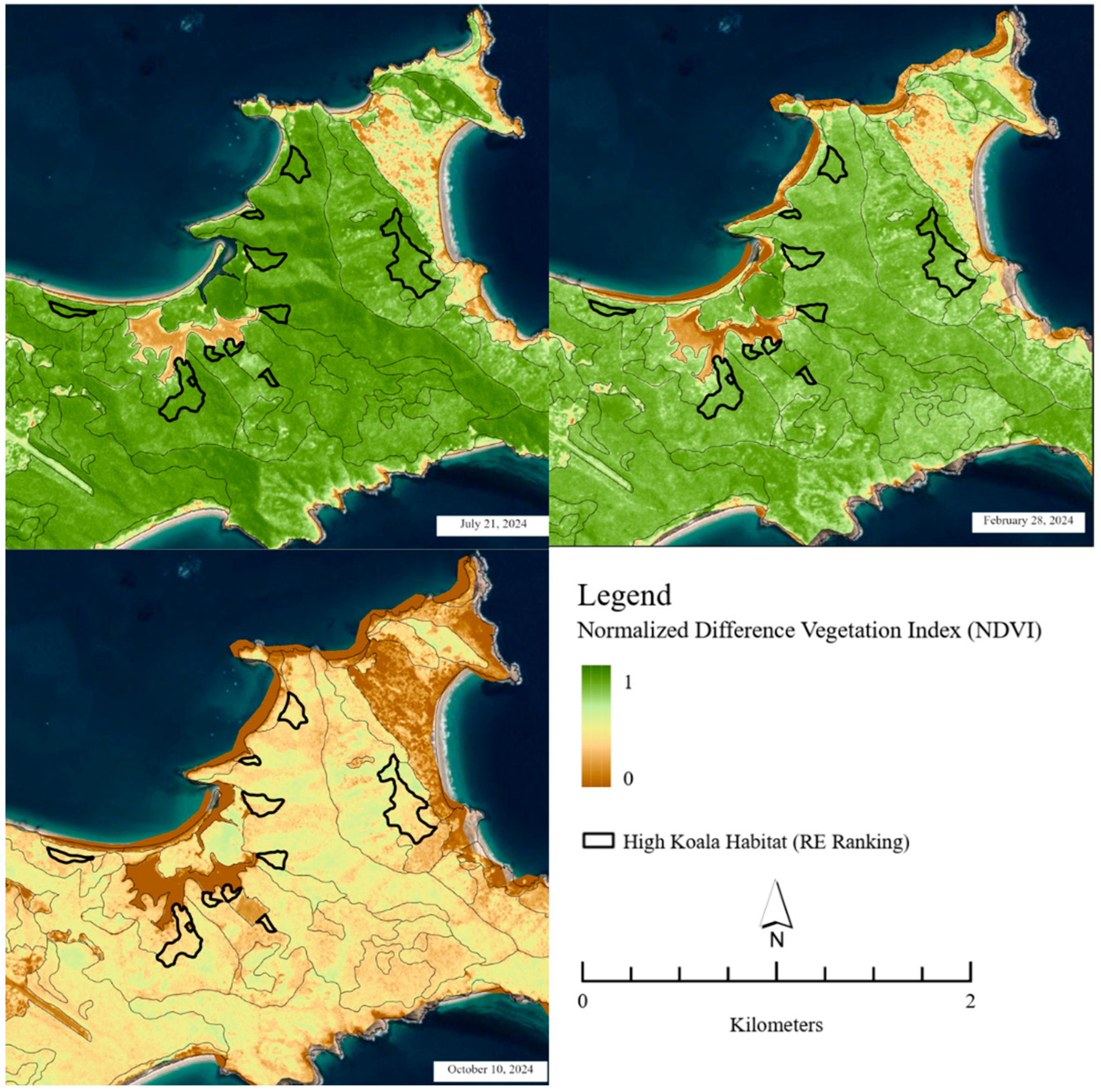
Seasonal NDVI values ranged from 0.40 (lowest) in October 2023 to 0.98 (highest) in July 2024. July (mid-dry season) recorded widespread high NDVI values (>0.90), while February 2024 (end wet season) had moderate-high values (0.62–0.90). October 2023 showed the lowest NDVI values, with most vegetation near 0.40–0.67 (Figure 3).
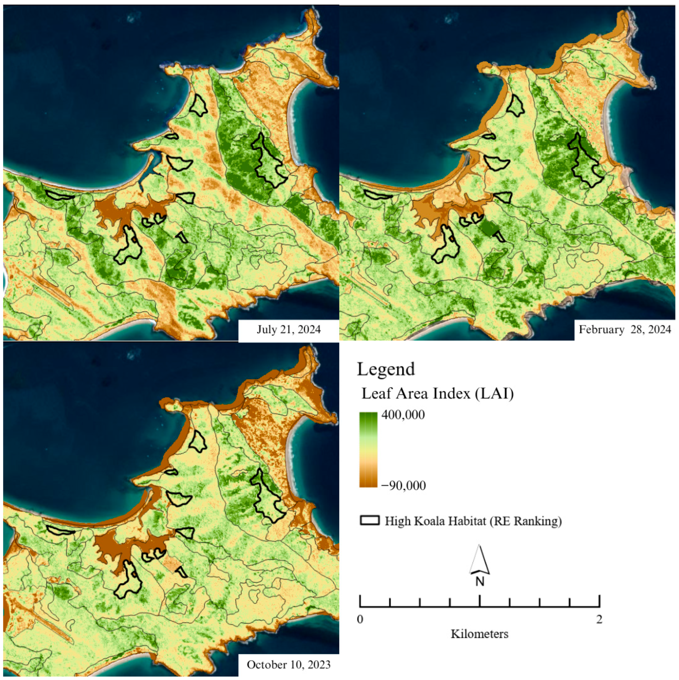
LAI values followed a similar seasonal trend, with highest values observed in February and lowest in October. High-ranking koala habitat areas tended to have relatively higher LAI values across all three time periods (Figure 4).

4. Discussion

The mapping results show that Woppa has very limited high-quality koala habitat (2.7% of vegetation), concentrated in land zone 3, where freshwater sources and preferred food species are present. The dominance of land zone 11, followed by land zone 2, which are lower in habitat suitability, raises concerns about the island’s capacity to sustain a long-term koala population without significant habitat management or restoration. While generally less suitable, such land zones are said to have the capacity to support koalas if soil and water conditions allow growth of preferred food species [9].
Comparable assessments across Central and Southeast Queensland likewise report that high-suitability koala habitat typically occurs as small, fragmented patches within broader mosaics of moderate- and low-quality vegetation. This pattern suggests that Woppa’s limited extent of high-quality habitat reflects regional ecological realities rather than a methodological anomaly, aligning with other studies employing comparable mapping frameworks and vegetation indices [8,19].
Rainfall records highlight the severity of recent conditions, with BoM data showing that the three months prior to the October 2023 imagery received 97% less rainfall compared to the same period in 2022 [26]. Despite this, certain high-ranking areas demonstrated resilience during dry periods, maintaining higher LAI values even under such extreme rainfall deficits. These resilient areas are primarily associated with land zone 3, which is characterised by the presence of freshwater sources and key food species [9]. Together, these findings suggest that while high-quality habitat is limited (2.7% of vegetation), land zone 3 may still hold ecological significance as a remnant of the vegetation structure that once supported koalas on Woppa. Areas currently classified as having ‘low’ habitat suitability may also contain vegetation characteristics of higher ecological value for koalas, and vice versa, underscoring the need for ground-truthing before any definitive conclusions can be drawn [8,9].
As NDVI and LAI are closely associated with canopy density and moisture retention, these indices act as indirect indicators of shading and evaporative cooling—factors that mitigate thermal stress in koalas [27,28]. Field studies on St Bees Island have shown that koalas utilise vine-thicket and rainforest patches for shelter during the day and feed in adjacent eucalypt forests at night [29]. This highlights that, on Woppa, the presence of dense or moisture-retaining vegetation may be as critical for shelter and microclimatic buffering as the availability of preferred food trees. Identifying and characterising such potential refuge habitats should therefore be a focus of future ground-truthing and ecological surveys.
The available evidence suggests that Woppa’s historic koala population had complex origins, with secondary sources indicating a naturally occurring population that persisted until European settlement, followed by a later translocation in the 1920s as part of early conservation restocking efforts [2]. Hunting and land clearing during colonial settlement have been identified as principal pressures driving declines in both mainland and island populations, prompting early attempts to replenish depleted populations through koala reintroductions [30]. On Woppa, an estimated 10–20 koalas were introduced, although the precise number remains unknown. Subsequent loss of habitat through pastoral development and resort construction, together with grazing by goats and other introduced species, likely reduced the island’s carrying capacity [2,15]. While there are no historical records of disease from Woppa, Chlamydia pecorum—a pathogen introduced to koalas following European settlement—may also have contributed to population stress [27]. Comparable island populations, such as those on St Bees, demonstrate that even where vegetation appears adequate, physiological stress and disease can limit long-term persistence, with infection detected in most adult females and some males [31]. These combined historical and ecological pressures likely led to the eventual extinction of koalas on Woppa.
Although koalas disappeared from the island in the past, under more favourable climatic conditions, the precise causes of extinction remain uncertain. They were more than likely influenced by human activities—particularly hunting, habitat clearance, and the introduction of non-native species—rather than habitat unsuitability alone [2,14,15]. With this said, if Woppa were protected from further development and introduced species were eradicated, it may be in a better position to support a small koala population. Accordingly, any future consideration of reintroduction would be a long-term prospect, contingent on substantial habitat restoration, weed and feral-animal control, and close collaboration with the Woppaburra People as Traditional Owners. Under improved ecological and cultural management, Woppa could eventually serve a temporary role in rehabilitation or in supporting the broader regional koala metapopulation but only following rigorous consultation and ecological validation [17,18,32].
The limited availability of high-quality koala habitat on Woppa highlights the importance of understanding dietary preferences and resource use in nearby populations. Studies from surrounding regions provide insight into how koalas adapt their feeding habits in response to local vegetation composition and habitat constraints. For example, the dietary composition on Rabbit Island is notable because Eucalyptus tereticornis, usually regarded as the preferred food species, constitutes only 20% of the diet [33]. This suggests that koalas in this population may have adapted to local availability or preference patterns. At Blair Athol, the alignment between the top diet species (E. populnea and E. crebra) and the most used daytime trees indicates a possible relationship between tree use behaviour and feeding preferences [34]. However, the high daytime use of E. melanophloia despite its low dietary contribution, and the absence of Acacia harpophylla from the diet despite its ranking in daytime use, suggest that factors other than feeding, such as shelter or thermoregulation, influence tree use [34]. Similar findings were reported on St Bees Island, where koalas selected cooler non-fodder trees during the hottest summer days, highlighting that microclimate can strongly influence habitat use in addition to food availability [35].
These patterns highlight the complexity of koala dietary ecology across Queensland and underscore the importance of considering both food availability and other ecological factors when assessing koala habitat quality. In this study, the classification of high-quality habitat was informed by the floristic composition of Regional Ecosystem (RE) mapping, incorporating dietary studies from Central Queensland islands that identified key fodder species such as E. tereticornis, E. crebra, and E. platyphylla [19,29]. However, remote-sensing data cannot confirm the specific Eucalyptus species present within mapped polygons—a recognised limitation of all remote-sensing koala habitat models. Ground-truthing will therefore be essential to verify the presence and abundance of these primary feed trees and to validate the correlation between high NDVI/LAI values and actual fodder species occurrence. Additionally, the seasonal availability of key species such as E. platyphylla, which loses foliage during dry seasons, may limit dietary options for koalas, whereas evergreen species like E. tereticornis provide consistent food resources throughout the year [9].
Climate change projections for the Livingstone Shire region predict reduced rainfall, increased evaporation, and more frequent heatwaves and droughts [32,36]. Such conditions could exacerbate vegetation stress and cause koala dehydration due to dependence on foliar moisture for hydration and lack of alternative water sources [27]. The potential resilience observed in land zone 3 habitats suggests these areas may function as localised micro-refugia that support vegetation persistence under short-term climatic stress; however, their capacity to sustain koala populations or act as long-term refugia remains highly uncertain. Understanding the true extent and stability of this resilience would require analysis of a broader time series of satellite imagery spanning multiple years and climatic events to capture longer-term temporal patterns in vegetation response.
Researchers have cautioned that mapped habitat classifications may overestimate primary food tree proportions, potentially leading to misplaced conservation priorities [8,9]. This is particularly relevant for Woppa, where high-value patches are few and an incorrect estimation could result in under-protection of genuinely critical habitat. Additionally, relying solely on koala occurrence records to rank habitat suitability risks overlooking areas that are unoccupied but functionally valuable, and misclassification can occur even when field evidence (e.g., faecal pellets) confirms use [8]. This reinforces the need for ground-truthing to verify the accuracy and ecological validity of the mapped habitat classes, particularly in relation to their vegetation composition.
Comparative island koala populations provide important insights for Woppa’s management and conservation. The St Bees Island population, which expanded from just 20 translocated individuals to around 300 koalas, relies heavily on E. tereticornis for approximately 90% of its diet [29]. This narrow dietary dependence highlights the critical importance of tree species diversity in sustaining koala populations—particularly where the genetic diversity of key tree species is bottlenecked, risking loss of food availability if the species were to decline. In contrast, Woppa’s diverse key food tree species composition may offer some resilience, but this underscores the need to prioritise verification that these species are in fact present on the island, as well as determine the distribution and abundance of important species, to avoid similar vulnerabilities. Although few species are classified as high-utility, overall species diversity supports ecosystem resilience and provides alternative food resources under changing climatic conditions. This observation is consistent with other Koala Research–CQ habitat assessments, which note that Central Queensland koala populations frequently utilise ‘medium’-ranked habitat types [29].

5. Conclusions

While Woppa exhibits pockets of potential high-quality koala habitat, particularly within land zone 3, these areas make up only a small fraction of the island and could be vulnerable to climatic stressors. Analysis of the NDVI and LAI outputs identified vegetation patches that maintained comparatively high values throughout the driest periods, indicating relative vegetation health despite their limited extent. While these areas show encouraging signs of short-term stability, the increasing unpredictability of rainfall patterns and the projected intensification of dry seasons due to climate change are likely to exacerbate pressures on habitats and reduce the persistence of even these resilient patches over time.
Given the limitations of this study and the preliminary nature of the data obtained, recommending koala translocation is beyond the scope of this paper. However, if reintroduction to Woppa were ever to be considered, an evidence-based, stepwise framework would be essential. The first step would involve validating the modelled habitat to refine the true boundaries of high-quality zones and identify areas that may have been misclassified. Next, habitat restoration or assisted natural regeneration could be used to expand the extent and connectivity of suitable vegetation—an approach requiring feasibility assessment of resource and cost implications relative to island scale and restoration methods. Long-term monitoring of these refined habitat zones would then support modelling of the island’s capacity to sustain a genetically viable koala population under future climate scenarios. Throughout these stages, collaboration with the Woppaburra People would ensure that ecological management is guided by Traditional Knowledge and conducted in accordance with Woppaburra cultural protocols. This aligns with Indigenous-led research principles of self-determination, integrity, and reciprocal knowledge partnerships, ensuring that future conservation planning is both scientifically rigorous and culturally grounded [37].
During this project, respectful discussions with members of the Woppaburra community provided valuable qualitative insight into how ecological science, climate adaptation, and Traditional Owner-led management can work together to guide future conservation. Embedding these perspectives into environmental planning offers a pathway for Woppa to become, over time, both a culturally significant and ecologically resilient landscape, through sustained commitment to habitat restoration, long-term monitoring, and collaborative consultation.

Author Contributions

Conceptualization, C.S. and M.H.; methodology, C.S. and M.H.; investigation, C.S., M.H. and S.G.; formal analysis, C.S.; writing—original draft preparation, C.S.; writing—review and editing, C.S., R.S. and M.H. All authors have read and agreed to the published version of the manuscript.

Funding

This research was funded by the CQUniversity’s Flora, Fauna, and Freshwater Research Cluster and Koala Research—CQ.

Institutional Review Board Statement

Not applicable.

Informed Consent Statement

Not applicable.

Data Availability Statement

The raw data supporting the conclusions of this article, where not subject to copyright or confidentiality conditions, will be made available by the authors on request.

Acknowledgments

The authors gratefully acknowledge funding from the CQUniversity Fauna, Flora and Freshwater Research Cluster and Koala Research—CQ that supported the logistics of the field work. We also acknowledge the Capricorn Conservation Council for their collaboration in coordination and training. We acknowledge the Traditional Owners of Woppa, the Woppaburra People and further acknowledge all Elders; keepers and carers of Country.

Conflicts of Interest

The authors declare no conflicts of interest.

Abbreviations

The following abbreviations are used in this manuscript:
NDVINormalised Difference Vegetation Index
LAILeaf Area Index
CQCentral Queensland
RERegional Ecosystem
NESPNational Environmental Science Programme
BoMBureau of Meteorology

References

  1. Department of Climate Change, Energy, the Environment, and Water: Koalas. Available online: https://www.dcceew.gov.au/environment/biodiversity/threatened/species/koalas (accessed on 22 August 2025).
  2. Danaher, M.; Shanks, D.; Jones, B.T.; Schlagloth, R. How Did They Get There? A History of Koalas on Queensland’s Islands. Aust. Zool. 2023, 43, 390–408. [Google Scholar] [CrossRef]
  3. Lee, K.E.; Seddon, J.M.; Johnston, S.; FitzGibbon, S.I.; Carrick, F.; Melzer, A.; Bercovitch, F.; Ellis, W. Genetic Diversity in Natural and Introduced Island Populations of Koalas in Queensland. Aust. J. Zool. 2013, 60, 303–310. [Google Scholar] [CrossRef]
  4. Eddie, M.J.; Ellis, W.A.; Kark, S. Koalas on Australian Islands. Biodivers. Conserv. 2025, 34, 3559–3587. [Google Scholar] [CrossRef]
  5. Stephen, P.; Callaghan, J. The Spot Assessment Technique: A Tool for Determining Localised Levels of Habitat Use by Koalas Phascolarctos Cinereus. Aust. Zool. 2011, 35, 774–780. [Google Scholar] [CrossRef]
  6. Callaghan, J.; McAlpine, C.; Mitchell, D.; Thompson, J.; Bowen, M.; Rhodes, J.; Jong, C.D.; Domalewski, R.; Scott, A. Ranking and Mapping Koala Habitat Quality for Conservation Planning on the Basis of Indirect Evidence of Tree-Species Use: A Case Study of Noosa Shire, South-Eastern Queensland. Wildl. Res. 2011, 2, 89–102. [Google Scholar] [CrossRef]
  7. Ellis, W.A.H.; Melzer, A.; Bercovitch, F.B. Spatiotemporal Dynamics of Habitat Use by Koalas: The Checkerboard Model. Behav. Ecol. Sociobiol. 2009, 63, 1181–1188. [Google Scholar] [CrossRef]
  8. Mitchell, D.L.; Soto-Berelov, M.; Langford, W.T.; Jones, S.D. Factors Confounding Koala Habitat Mapping at Multiple Decision-Making Scales. Ecol. Manag. Restor. 2021, 22, 171–182. [Google Scholar] [CrossRef]
  9. Melzer, A.; Vise, A. Mapping Central Queensland’s Koala Habitat Using Queensland’s Mapped Regional Ecosystems; Koala Research–CQ, Central Queensland University: Rockhampton, QLD, Australia, 2016. [Google Scholar]
  10. Raffini, F.; Bertorelle, G.; Biello, R.; D’Urso, G.; Russo, D.; Bosso, L. From Nucleotides to Satellite Imagery: Approaches to Identify and Manage the Invasive Pathogen Xylella Fastidiosa and Its Insect Vectors in Europe. Sustainability 2020, 12, 4508. [Google Scholar] [CrossRef]
  11. Song, F.; Wenyong, Z.; Tenggang, Y.; Zhenqing, J.; Zhiyu, C.; Baorong, X.; Lei, L.; Songbing, Z. Uav Quantitative Remote Sensing of Riparian Zone Vegetation for River and Lake Health Assessment: A Review. Remote Sens. 2024, 16, 3560. [Google Scholar] [CrossRef]
  12. Hewson, M.; Santamaria, F.; Melzer, A.; Melzer, R. Tools for Assessing Queensland’s Koala Habitat Condition; Koala Research CQ Central Queensland University: Rockhampton, QLD, Australia, 2019. [Google Scholar]
  13. Melzer, R.; Plumb, J. Plants of Capricornia, 1st ed.; Belgamba: Rockhampton, QLD, Australia, 2011; p. 22. [Google Scholar]
  14. Creighton, C. Keppel Islands Environmental Survey: A Baseline for Archaeological Reconstructions and Resource Management; Archaeology Branch, Department of Community Services: Brisbane, QLD, Australia, 1984. [Google Scholar]
  15. Morris, A.J. My Island in the Sun: An Early History of Great Keppel Island; A.J. Morris: Emu Park, QLD, Australia, 1989. [Google Scholar]
  16. Australian Museum: Woppaburra People of the Keppel Islands. Available online: https://australian.museum/learn/cultures/atsi-collection/woppaburra-people-of-the-keppel-islands/ (accessed on 2 September 2025).
  17. Woppaburra: Woppaburra Tumra. Available online: https://woppaburra.com.au/100-2/ (accessed on 2 September 2025).
  18. Australian Institute of Aboriginal and Torres Strait Islander Studies: Muir on Behalf of the Woppaburra People V State of Queensland. Available online: https://aiatsis.gov.au/ntpd-resource/2206 (accessed on 2 September 2025).
  19. Runge, C.; Rhodes, J.; Lopez-Cubillos, D.S. Mapping Koala Habitat for Greater Queensland Report; NESP Threatened Species Recovery Hub: Brisbane, QLD, Australia, 2021. [Google Scholar]
  20. Law, B.; Caccamo, G.; Roe, P.; Truskinger, A.; Brassil, T.; Gonsalves, L.; McConville, A.; Stanton, M. Development and Field Validation of a Regional, Management—Scale Habitat Model: A Koala Phascolarctos Cinereus Case Study. Ecol. Evol. 2017, 7, 7475–7489. [Google Scholar] [CrossRef] [PubMed]
  21. Department of Environment, Science and Innovation: Search Regional Ecosystem Descriptions. Available online: https://apps.des.qld.gov.au/regional-ecosystems/ (accessed on 18 August 2025).
  22. Planet: Planet Imagery Product Specifications. Available online: https://assets.planet.com/docs/combined-imagery-product-spec-april-2019.pdf (accessed on 20 August 2024).
  23. Hewson, M.; Santamaria, F.; Melzer, A. Field Testing Satellite-Derived Vegetation Health Indices for a Koala Habitat Managers Toolkit. Remote Sens. 2022, 14, 2119. [Google Scholar] [CrossRef]
  24. Nouri, H.; Beecham, S.; Anderson, S.; Nagler, P. High Spatial Resolution Worldview-2 Imagery for Mapping Ndvi and Its Relationship to Temporal Urban Landscape Evapotranspiration Factors. Remote Sens. 2014, 6, 580–602. [Google Scholar] [CrossRef]
  25. Eldner, V.J.; Wilson, B.A.; Dillewaard, H.A.; Ryan, T.S.; Butler, D.W.; McDonald, W.J.F.; Richter, D.; Addicott, E.P.; Appelman, C.N. Methodology for Survey and Mapping of Regional Ecosystems and Vegetation Communities in Queensland; Version 7.0. Updated December 2023; Queensland Herbarium, Queensland Department of Environment, Science and Innovation: Brisbane, QLD, Australia, 2023. [Google Scholar]
  26. Bureau of Meteorology: Recent and Historical Rainfall Maps. Available online: http://www.bom.gov.au/climate/maps (accessed on 9 October 2024).
  27. Valentina, M.S.A.; Cooper, C.E.; Karr, M.K.; Krockenberger, A.; Madani, G.; Webb, E.B.; Krockenberger, M.B. Hot Climate, Hot Koalas: The Role of Weather, Behaviour and Disease on Thermoregulation. Conserv. Physiol. 2024, 12, coae032. [Google Scholar] [CrossRef] [PubMed]
  28. Briscoe, N.J.; Handasyde, K.A.; Griffiths, S.R.; Porter, W.P.; Krockenberger, A.; Kearney, M.R. Tree-Hugging Koalas Demonstrate a Novel Thermoregulatory Mechanism for Arboreal Mammals. Biol. Lett. 2014, 10, 6. [Google Scholar] [CrossRef] [PubMed]
  29. Melzer, A.; Baudry, C.; Kadiri, M.; Ellis, W.A. Tree Use, Feeding Activity and Diet of Koalas on St Bees Island, Queensland. Aust. Zool. 2011, 35, 870–875. [Google Scholar] [CrossRef]
  30. Gordon, G.; Hrdina, F. Koala and Possum Populations in Queensland During the Harvest Period, 1906–1936. Aust. Zool. 2005, 33, 69–99. [Google Scholar] [CrossRef]
  31. Ellis, W.; Melzer, A.; FitzGibbon, S.; Hulse, L.; Gillett, A.; Barth, B. Koalas of the Clarke Connors range. Aust. Mammal. 2022, 45, 160–170. [Google Scholar] [CrossRef]
  32. Livingstone Shire Council: Our Living Environment Biodiversity Strategy 2021–2027. Available online: https://www.livingstone.qld.gov.au/files/assets/public/v/1/your-council/documents/biodiversity_strategy_reduced.pdf (accessed on 10 January 2025).
  33. Manno, G. What Does Koala Eats on Rabbit Island; Central Queensland University: Rockhampton, QLD, Australia, 2010. [Google Scholar]
  34. Ellis, W.A.H.; Melzer, A.; Carrick, F.N.; Hasegawa, M. Tree Use, Diet and Home Range of the Koala (Phascolarctos Cinereus) at Blair Athol, Central Queensland. Wildl. Res. 2002, 29, 303–311. [Google Scholar] [CrossRef]
  35. Dalene, A.; Archibald, C.L.; Barth, B.J.; FitzGibbon, S.I.; Melzer, A.; Gillett, A.K.; Johnston, S.D.; Beard, L.; Ellis, W.A. The Thermal Niche of the Koala (Phascolarctos Cinereus): Spatial Dynamics of Home Range and Microclimate. Animals 2025, 15, 2198. [Google Scholar] [CrossRef] [PubMed]
  36. Ogge, M. Climate Assessment for the Electorate of Capricornia; The Australian Institute: Canberra, ACT, Australia, 2019. [Google Scholar]
  37. George, S.; Kemp, S.; Kemp, M.; Hewson, M.; Hosking, H.; Mani, J.; Du Preez, R.; Naiker, M. Exploring Indigenous-Led Research through a Reflexive Pathway from an Australian Context. Aust. Aborig. Stud. 2025, 1, 46–74. [Google Scholar]
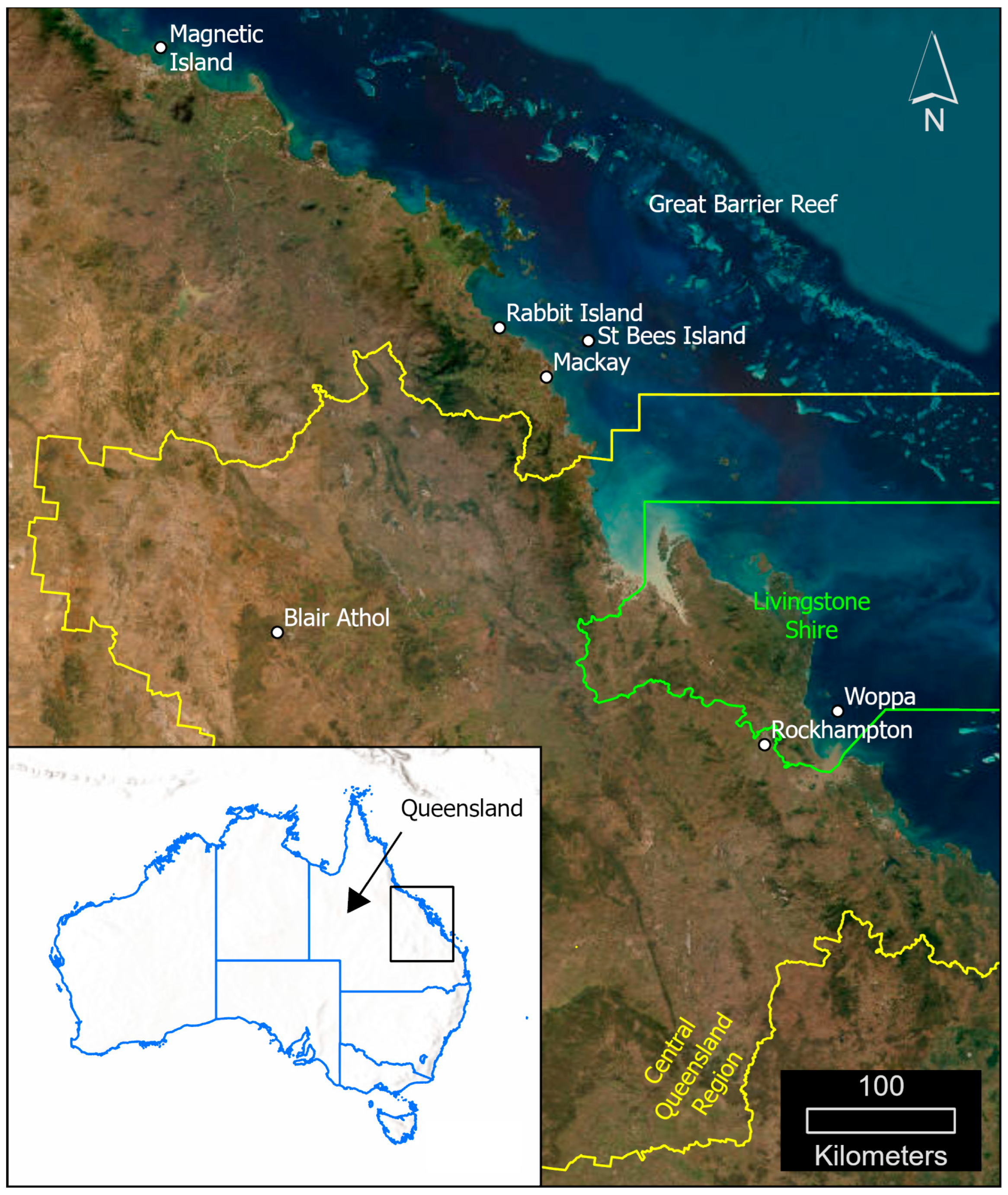
Figure 1. Study area map showing Woppa on the Queensland coast near Rockhampton, along with other islands and regions discussed in this paper. The inset map indicates the location of Queensland within Australia.
Conservation 05 00072 g001
Figure 2. The Koala Habitat Ranking Assessment Map was generated using ArcGIS Pro and PlanetLabs imagery. Results were based on the QLD Herbarium RE layer [25], Koala Habitat Ranking Assessment Layer [21], and a land cover ranking model for koala habitat [9]. Rankings range from ‘none’ to ‘high’ and are associated with land zones, with coverage percentages calculated for each land zone across the island.
Conservation 05 00072 g002
Figure 3. Normalised Vegetation Difference Index (NDVI) for PlanetLabs images processed in ArcGIS Pro using the NDVI band arithmetic function representing seasonal differences. July 2024 (top left) mid dry-season, February 2024 (top right) end of wet season, and October 2023 (bottom left) end of dry season. The NDVI value 1.0 represents the maximum vegetation health and ≤0 is no vegetation. The ‘High Koala Habitat’ RE Ranking layer is included as an area of interest.
Conservation 05 00072 g003
Figure 4. Leaf Area Index (LAI) for PlanetLabs images processed in ArcGIS Pro using the band arithmetic function with NIR, Red and Green bands, representing seasonal differences. July 2024 (top left) mid dry-season, February 2024 (top right) end of wet season, and October 2023 (bottom left) End of dry season. The ‘High Koala Habitat’ RE Ranking layer is included as an area of interest. Higher value indicates higher leaf colour.
Conservation 05 00072 g004
Table 1. Ranking attribute descriptions of RE koala habitat suitability [19].
RE AttributesRE Suitability
Very HighHighMediumNon-Habitat
Koala tree species present in RE YesYesYesYes
Utility of tree species to koalas HighMediumHigh or Medium
Records of koalas since 1970 YesYesYesNo
% of RE polygons that contain koala records >1%>1%Any
Table 2. PlanetLabs SuperDove satellite characteristics—2024 Planet Labs PBC [22].
CharacteristicsInformation
Number of Satellites 430+ (Dove and SuperDove)
Orbit Altitude 475–525 km in Sun-synchronous orbit
Equator Crossing Time 9:30–11:30 a.m. local solar time
Sensor Type Eight-band frame imager with butcher-block filter
Spectral Bands Coastal Blue 431–452 nm
Blue: 465–515 nm
Green I: 513–549 nm
Green: 547–583 nm
Yellow: 600–620 nm
Red: 650–680 nm
Red-Edge: 697–713 nm
NIR: 845–885 nm
Pixel Size (orthorectified) 3 m (resampled from 3.7 to 4.2 m)
Swath Width 4 degrees
Frame Size 32.5 × 19.6 km
Revisit Time Daily (at nadir)
Dynamic Range 12 Bit
Table 3. Land zone definitions displaying relevant land zones as found on Woppa, the description, usage by koalas and the associated habitat value ranking from zero to five [9].
DescriptionUsageHabitat Value (0–5)
Land Zone 1Unconsolidated Quaternary marine sediments (mangrove and salt flats)Koalas traverse but do not feed on mangrove species.0
Land Zone 2Quaternary coastal dunes and beach ridges.Koalas use when adequate soil and hydrology for food species are available; however, they are limited by low fertility, seasonal water deficits and fire risks.2
Land Zone 3Quaternary alluvium associated with rivers and streamsForms the core of most koala populations. Characterised by availability of key food species, good underlying aquifers and being relatively fertile.5
Land Zone 11Lowlands, hills, and ranges of moderately to strongly deformed metamorphic rock.Koalas are known to utilise land when suitable tree species are present and adequate aquifers are available; however, land can be prone to seasonal droughts.2
Table 4. Tree species taken from the description of each Regional Ecosystem [21]. The REs present on Woppa were identified using the QLD Herbarium RE layer and ranked using the associated koala tree list dataset [19].
Koala Tree SpeciesSpecies UtilityAssociated Land Zones
Eucalyptus camaldulensisHigh2, 11
E. tereticornisHigh2, 11
E. crebraMedium2, 11
E.drepanophyllaMedium2, 3, 11
E. portuensisMedium2, 11
E.platyphyllaMedium3, 11
E.moluccanaMedium2, 11
E. exsertaMedium2, 11
E. latisinensisMedium2
Corymbia citriodoraMedium2, 11
C. trachyphloiaMedium11
C. intermediaMedium2, 11
C. clarksonianaMedium2, 3, 11
C. dallachianaMedium3, 11
C. tessellarisMedium2, 3, 11
Lophostemon confertusMedium11
L. suaveolensMedium2, 3, 11
Melaleuca quinquenerviaMedium11
M. nervosaMedium2, 3
M. dealbataMedium2, 3
M. viridifloraNone/unknown2, 3
Allocasuarina littoralisMedium2, 11
Casuarina equistetifoliaMedium2
C. cunninghamianaNone/unknown3
C. cristataNone/unknown2
Disclaimer/Publisher’s Note: The statements, opinions and data contained in all publications are solely those of the individual author(s) and contributor(s) and not of MDPI and/or the editor(s). MDPI and/or the editor(s) disclaim responsibility for any injury to people or property resulting from any ideas, methods, instructions or products referred to in the content.