Abstract
The 2023 storm Daniel hit areas of Greece, Bulgaria, Turkey and Libya, leading to severe flooding phenomena. One of the severely affected areas was the Thessaly Region in central Greece, which was subjected to extreme precipitation, with historic record rainfalls. This paper presents an overview of the observed damage to the built environment (buildings, bridges, slopes, etc.) and the resulting soil response or soil–structure interaction phenomena associated with the severe flooding caused by storm Daniel. To assist readers, reported cases of damage and supporting evidence (such as photos, rainfall level, etc.) are introduced in an interactive map of the affected area, illustrating the spatial effects of this severe storm on the built environment.
1. Introduction
The exposure of societies to heavy rainfalls and floods may lead to excessive losses, affecting people and world economies [1]. According to the Emergency Events Database (EM-DAT) of the Centre for Research on the Epidemiology of Disasters (CRED) [2], 164 floods and 139 severe storms were recorded in 2023 worldwide, causing 7763 and 14,666 casualties, respectively [2]. It is worth noting that the above numbers of casualties are higher than the average annual values reported for the period 2003–2022 [2]. The effects of heavy rainfall and floods on built environment infrastructure may be disastrous [1]. Heavy rainfalls and flooding may lead to considerable damage to lifelines and transportation networks. For instance, heavy rainfalls and floods may lead to excessive scour phenomena at the foundations of roads or railway bridges crossing rivers or streams. In many cases, such phenomena may result in severe damage or even collapse of bridges, leading to traffic disruptions and significant downtimes [3]. Heavy rainfalls may also result in landslides of slopes and embankments and cuts to road and railway networks [4]. Heavy rainfall in the UK in 2007 severely impacted the road network, with repair costs estimated at £60 million [5]. Similarly, during the 2009 floods in Cumbria, at least 20 bridges were either destroyed or damaged, resulting in one fatality, £34 million in repair and replacement costs and significant societal consequences [6]. In 2012, flooding caused damage to 131 bridges in the same region, primarily due to scour [7]. Additionally, floods may induce severe damage in buildings due to the combined effects of wave forces and debris impact. The economic losses associated with floods reported in 2023 are estimated to equal USD 20.4 billion, whereas the losses for storms are estimated at around USD 100.8 billion [2].
The effects of natural hazards, such as heavy rainfalls or storms and floods, may be amplified due to climate change that causes more intense weather and climatic events [8]. An increasing trend in the severity and frequency of extreme storm events, heavy rainfalls and floods has been reported in many countries, with a significant impact on the natural and built environment. In July 2021, several European countries were struck by severe flooding, some of which was catastrophic, leading to numerous deaths and extensive damage. The floods began as flash floods in the United Kingdom, causing property damage and disruptions. As the situation worsened, floods affected multiple river basins across Europe, including Austria, Belgium, Croatia, Germany, Italy, Luxembourg, the Netherlands and Switzerland. The floods claimed at least 243 lives and caused tremendous damage to the built environment [9,10]. On 29 October 2024, heavy rain brought more than a year’s worth of precipitation to several regions in eastern Spain, including the Valencian Community, Castilla–La Mancha and Andalusia. The resulting floods led to the deaths of approximately 232 people and caused significant property damage. This event is considered one of the deadliest natural disasters in Spain’s history [11]. Similar phenomena have been reported in Greece as well [12,13]. A representative example is that of storm Daniel, which impacted Thessaly Region in central Greece in September 2023, resulting in 18 casualties and tremendous damage to livestock, buildings, road and railway infrastructure assets, lifelines, agricultural land and vehicles [14,15].
This paper presents a case study on the effects of climate change on the built environment, focusing on soil failures and damage associated with soil–structure interaction phenomena triggered by storm Daniel and subsequent flooding. Cases of reported damage to buildings, bridges, slopes, cuttings and embankments of the road and rail network as well as to lifelines are highlighted. The mechanisms that potentially led to damage in each presented case are discussed. To assist readers, reported cases of damage and supporting evidence (such as photos, rainfall level, etc.) are introduced in an interactive map of the affected area, illustrating the spatial effects of this severe storm on the built environment.
2. Thessaly Region in Central Greece
Thessaly Region (Figure 1) is divided into four Regional Units: the Regional Unit of Larissa, the Regional Unit of Magnesia and Sporades, the Regional Unit of Trikala and the Regional Unit of Karditsa. The lower parts of the western and central region are characterized by a flat terrain; i.e., the Thessaly Plain, with agriculture being the main land use in the area. The climate of the western and central areas of the terrain is characterized as continental, i.e., cold winters and hot summers, whereas for the eastern part, the climate is characterized as Mediterranean [16]. The Thessaly Plain is mainly surrounded by high mountains that receive substantial amounts of rainfall, and it is crossed by Pineios River, the third longest river in Greece. With a length of around 260 km, Pineios originates from the Pindos Mountains and empties into the Aegean Sea, crossing the valley of Tempi. Other quite large rivers originating from the surrounding mountains, such as Enipeas River, flow into Pineios River, thus increasing significantly the discharge of the latter. The mountain of Pelion (Mt. Pelion) is located on the eastern part of the terrain, forming quite steep slopes and a lot of major or minor streams (such as the Krafsidonas stream in the western part of the mountain and the Galanorema stream in the eastern part of the mountain). The streams in the western part of the mountain cross either the city of Volos (population around 140,000) or villages and empty into the Pagasitikos gulf, whereas the streams in the eastern part of the mountain cross villages and empty into the Aegean Sea. The eastern part of Mt. Pelion is much steeper than the western part of it.
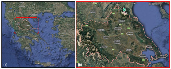
Figure 1.
(a) Thessaly Region in central Greece; (b) the main cities in Thessaly Region (source: Google Maps).
The Thessaly Plain in Greece has long struggled with flooding, especially due to wetlands and marshes that existed on a large scale in the area until the early 20th century. To address this, Greek governments commissioned large-scale flood control projects starting in 1934, including the draining of Lake Karla in 1961, which reclaimed fertile land and improved living conditions. Additional measures, such as the development of irrigation systems, the restoration of Lake Karla and the Smokovo Dam (which contains floods in a small upstream basin), further reduced flooding risks. Despite these efforts, Pineios River still faces frequent floods, with twenty-two severe events recorded since 1979 [15]. Recent events have been reported during the fall season (for instance, the 1994 flood in Metamorfosi village occurred in October, the 2016 flood of the Lithaios River in Trikala city occurred in September and the 2020 flood due to Ianos Medicane affected the area in September) [15]. The main causes of flooding include closed basins, requiring pumping for drainage, limited discharge capacity in the river network due to vegetation and sediment buildup, insufficient infrastructure (small bridges and culverts), levee and gate failures, temporary irrigation dams and accelerated runoff from mountain basins due to land-use changes [16].
3. Storm Daniel and Subsequent Flooding Phenomena
Storm Daniel was a slow-moving storm system which formed in the first week of September 2023 in the Mediterranean Sea and developed into a Mediterranean hurricane-like storm (Medicane) within a week. Thessaly Region in central Greece was subjected to extreme precipitation, with historic record rainfall. The storm was the result of an omega block: a high-pressure zone sandwiched between two zones of low pressure, with the isobars shaped like the Greek letter omega (Ω). Table 1 summarizes the daily precipitation recorded by several meteorological stations across Thessaly between the 4 September 2023 and the 7 September 2023. The total 4-day precipitation is also provided for each station [16]. Indicative of the event severity are the data from the stations in Zagora and Makrinitsa villages (Mt. Pelion), which recorded 1096 mm and 1235 mm in 4 days, respectively. These extreme, record-high values are far greater than the average month or annual precipitation in the affected area and the Greek land in general. Figure 2 compares an average month’s precipitation recorded in various meteorological stations of the affected area in September with the maximum daily precipitation recorded during storm Daniel in the same meteorological stations. The differences are significant in all meteorological stations.

Table 1.
Meteorological stations in the affected area with daily and total precipitation recorded during storm Daniel (4 September 2023 to 7 September 2023). NOA: National Observatory of Athens (https://www.meteo.gr/, accessed on 12 December 2024). Information partially acquired from Dimitriou et al. [16].
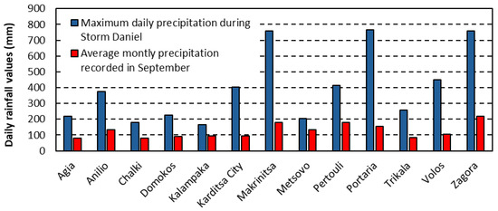
Figure 2.
Comparisons of an average month’s precipitation recorded in various meteorological stations of the affected area in September with the maximum daily precipitation recorded during storm Daniel in the same meteorological stations (data retrieved from https://www.meteo.gr/, accessed on 12 February 2025).
Dimitriou et al. [16] estimated the return periods of the storm for each meteorological station for three temporal scales (durations), i.e., 24 h, 48 h and 72 h, by employing recently updated intensity–duration–frequency relationships (referred to as ombrian curves) developed by Koutsoyiannis et al. [17]. Table 2 summarizes these estimations, highlighting the rarity and extreme nature of the phenomenon.
Table 2.
Return periods of storm Daniel estimated for various temporal scales (durations) based on a probabilistic analysis across meteorological stations carried out by Dimitriou et al. [16].
The 4-day heavy rainfall resulted in major flooding in Thessaly Region, thus causing massive destruction to transportation infrastructure, lifelines and buildings. Storm Daniel was also one of the deadliest weather events in the recent history of Greece, with a total of 18 casualties [15]. Extremely large areas of land (mainly agricultural) flooded and remained submerged for several days, and even weeks. Settlements and cities were also severely affected, with some villages remaining submerged for several days. Figure 3 presents an image captured on 10 September 2023 (3 days after storm Daniel moved from the area) by one of the Copernicus Sentinel-2 satellites, showing the area of Larissa, which was heavily affected by flooding caused by the overflow of Pineios River. Figure 4 compares images of Larissa Region and Trikala Region before and after storm Daniel as captured by one of the Copernicus Sentinel-2 satellites, highlighting the extent of the flooding. The images focus on major flooded areas, i.e., Palamas town, Metamorfosi village, the suburbs of Larissa city and Lake Karla. Figure 5 presents a satellite image captured by Copernicus Sentinel-2 satellite on 20 September 2023 showing the remaining agricultural areas submerged southeast of Larissa, in the area of Lake Karla. The area remained submerged for several months after the storm.
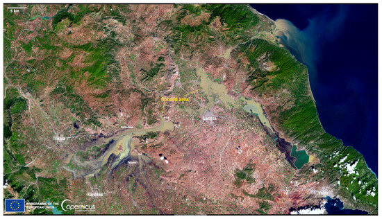
Figure 3.
Satellite image of Larissa Region captured on 10 September 2023 by one of the Copernicus Sentinel-2 satellites (source: European Union, Copernicus Sentinel-2 imagery, https://www.copernicus.eu/en/media/image-day-gallery/extensive-floods-greece, accessed on 22 December 2024).
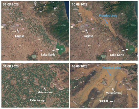
Figure 4.
Satellite images of Larissa Region and Karditsa Region captured on 31 August 2023 and 10 September 2023 by one of the Copernicus Sentinel-2 satellites (source: European Union, Copernicus Sentinel-2 imagery).
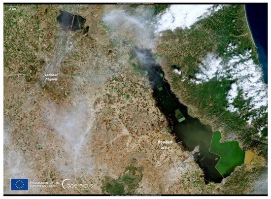
Figure 5.
Satellite image of Larissa Region captured on 20 September 2023 by one of the Copernicus Sentinel-2 satellites (source: European Union, Copernicus Sentinel-2 imagery).
The satellite images presented above highlight the extent of the flooded areas after the storm. Flooded areas included suburbs of the cities of Larissa and Trikala. Figure 6a,b present representative images of the flooded areas in the suburbs of the city of Larissa. Figure 6c shows an aerial view of flooded areas around Metamorfosi village, whereas Figure 6d presents views of flooded areas in the city of Trikala. The city of Volos was also severely affected by flooding phenomena that occurred during and after storm Daniel. One of the two main streams crossing the city, i.e., Krafsidonas stream, overflowed, resulting in severe damage (Figure 7).
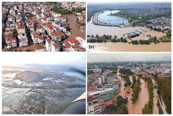
Figure 6.
Aerial views of flooded areas after storm Daniel: (a) Ayios Thomas district in Larissa city, located close to Pineios River (source: Youtube channel Larissanet OnlineNewspaper, https://www.youtube.com/watch?v=yahcrduNaPQ, accessed on 22 December 2024); (b) Giannouli district in Larissa city (source: Youtube channel Xaris Papantonis, https://www.youtube.com/watch?v=IG5tir1DUt0, accessed on 22 December 2024); (c) Metamorfosi village (source: Facebook account ErmisAirclub, https://www.facebook.com/AirclubHermes, accessed on 22 December 2024); (d) the city of Trikala (source: https://www.trikalavoice.gr/, accessed on 22 December 2024).
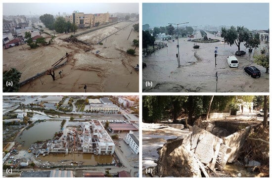
Figure 7.
(a) View of the overflowing Krafsidonas stream in the city of Volos (source: https://magnesianews.gr/, accessed on 23 December 2024); (b) flooded area in the suburb of Palea in the city of Volos (source: https://magnesianews.gr/, accessed on 23 December 2024); (c) flooded area on the construction site of the new building-block of the department of civil engineering of the University of Thessaly, located near Krafsidonas stream (source: personal archive); (d) collapse of a culvert in Ano Meria in Volos city (source: personal archive).
4. Damage to the Built Environment
4.1. Overview and Interactive Map
As already mentioned, flooding phenomena following storm Daniel caused considerable damage to the built environment. This section provides a detailed report on (a) major structural damage to buildings (mainly due to foundation soil failures), (b) damage to the road network, (c) damage to bridges (i.e., road bridges, historical bridges and pedestrian bridges), (d) landslides and soil erosion, and (e) damage to public buildings, technical works, other infrastructure and lifelines. For the purposes of this paper, reported cases of damage and supporting evidence (e.g., representative photos and precipitation data from nearby meteorological stations) were introduced by the authors in an interactive map of the affected area, which was made using My Maps provided by Google. The link to the map is given in the caption to Figure 8, where a screenshot of the interactive map is provided. As shown in Figure 8, the map comprises eight layers of information, with each one containing several data. Data for each layer are represented by a pin at the exact location of the reported case or meteorological station (except for the data for rivers and streams, which are represented by lines following their paths, and data referring to flooded areas, which are represented by highlighted areas). The layers include the following:
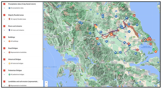
Figure 8.
Interactive map containing information on reported damage to the built environment after storm Daniel, as well as information from meteorological stations (source: Google My Maps https://www.google.com/maps/d/u/0/viewer?mid=1NxekqWcLAati4Mzaeft45UYmNBG8oP0&ll=39.58875136435664%2C21.90622976802615&z=7&hl=en, accessed on 7 January 2025).
- the 4-day total precipitation data for the stations presented in Table 1;
- the major flooded areas, as approximated from satellite images on 10 September 2023;
- the rivers and streams mentioned throughout Section 4;
- the buildings mentioned in Section 4.2;
- the road bridges mentioned in Section 4.4;
- the historical bridges mentioned in Section 4.4;
- the pedestrian bridges mentioned in Section 4.4;
- some representative landslides described in Section 4.5.
Consulting the map while studying the paper is strongly recommended. Users of this interactive map have the option of enabling or hiding layers on demand. Transition between terrain and satellite mode is also available.
4.2. Damage to Buildings
4.2.1. Overview of the Effects of Flooding on Buildings
The extensive floods that followed storm Daniel affected residential buildings, public buildings and warehouses and barns in villages, towns and cities, leading to significant damage, mainly due to the water and mud that flooded the buildings, causing damage to household furnishings and belongings, electrical appliances, machinery, etc. Table 3 summarizes the findings of post-event building inspections carried out by authorities (Region of Thessaly). Structural damage to buildings was relatively limited and is described below.
Table 3.
Summary of inspections of buildings conducted after storm Daniel [10].
4.2.2. Structural Damage to Buildings
As discussed, the 4-day continuous heavy rainfall in Thessaly Region pushed existing streams or rivers to exceed their man-made or naturally formed boundaries. As a result, cases of building collapses were recorded (either a total collapse of the whole building or a collapse of part of the building, i.e., a partial collapse). Two main forms of damage were reported:
- Partial or total collapses of buildings with load-bearing masonry walls made of brick, adobe or natural stone.
- Settlement and/or rotation of reinforced concrete buildings at their foundation level due to the significant erosion (scouring) of the underlying soil beneath the foundation. In most cases, the buildings were rotated at their foundations as rigid bodies.
The first damage mechanism reported mainly cases of non-engineered buildings that remained submerged for several days in the flooded areas (for instance, in villages of Trikala Region, Figure 6c). One of the main mortar materials for these structures is clay, which, under the effect of water, may erode, losing its strength (Figure 9). This phenomenon may explain reported damage to such buildings due to flooding phenomena. Scouring phenomena beneath the foundations of these buildings may have also caused severe damage or even collapse.
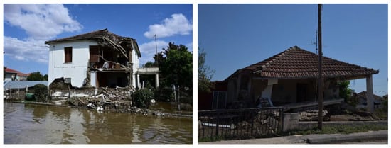
Figure 9.
Damage induced by flooding of non-engineered residential buildings in villages of Karditsa Region (source: [15] and personal archive).
For the second identified form of damage, all affected buildings were built along streambeds. Their collapse was the result of scouring phenomena at the buildings’ foundation level and below. All buildings comprised characteristics of typical shallow foundations. Further details are described below:
- The first case was the partial collapse of a two-storey elderly care house located in the city of Volos, which was built next to Krafsidonas stream. Figure 10a shows part of the collapsed building (highlighted in a circle in Figure 10a), with the remaining debris sitting at the bottom of the formed stream. A truck can also be observed next to the debris.
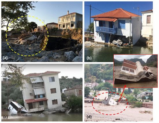 Figure 10. Failures of buildings sitting next to streams/rivers in (a) Volos city (source: personal archive), (b) Chorto village (source: personal archive), (c) Platania village (source: personal archive), and (d) Mouzaki town (source: [10]).
 - The second case (Figure 10b) refers to a two-storey house located in the village of Chorto, on the southeast side of Mt. Pelion. This house was built at the edge of a small river’s mouth, and as a result of the scouring phenomena at the foundation level, the house experienced partial settlement, leading to permanent, non-reversible deformations.
- Similarly, the third case (Figure 10c) refers to a three-storey residential building experiencing excessive differential settlement of the foundation. The location of this building was at the southern edge of Mt. Pelion, in Platania village.
- The fourth case, shown in Figure 10d, was a two-storey building with one basement which totally collapsed as a solid body. This collapse was again the result of the severe forces developed as a result of the flooded river next to it (Pamisos River). The extreme discharge in the river and its high-speed flow caused gradual degradation of the naturally formed soil embankments. Thus, in order to accommodate the extreme flow demands, the width of the river increased from 120.0 m to 220.0 m, as shown in Figure 11 (the collapsed structure has been marked with a circle). This building was located in Mouzaki town, which is on the west side of Thessaly Region, close to the city of Karditsa, approximately 120 km in a straight line from Mt. Pelion.
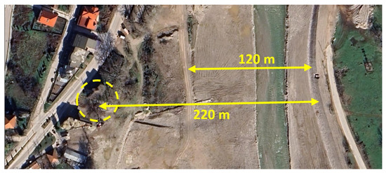 Figure 11. Satellite image of Pimasos River next to Mouzaki village before storm Daniel (source: Google earth. Date of image: 28 January 2023).
 - Finally, the fifth case refers to a part of a residential building in the village of Chania on Mt. Pelion. Part of the basement of the building collapsed due to ground erosion beneath its foundation caused by water flowing with high speed in a nearby stream that crosses the village (Figure 12).
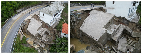 Figure 12. Collapse of part of a building in Chania, Mt. Pelion, due to scouring phenomena at its foundation (source: Region of Thessaly).
4.3. Damage to the Road Network
The extended flooding phenomena in Thessaly due to storm Daniel resulted in significant damage to the road network of the affected area. Table 4 provides metrics regarding flood-induced damage to the road network reported in four Regional Units of Thessaly, based on data from the Ministry of Infrastructure and Transport of Greece. Metrics are also provided for the Regional Unit of Fthiotida (located southwest of the Region of Thessaly), even though it does not belong administratively to the Region of Thessaly. According to these recordings, 24 out of 79 bridges collapsed or were severely damaged.
Table 4.
Flood-induced damage to the road network of the affected area as reported after storm Daniel (source: https://www.kathimerini.gr/, accessed on 23 December 2024).
In addition to the damage to the local road network of the affected area, the Athens-Thessaloniki National Road (a four-lane motorway, with two per traffic direction) was inundated by flood waters for several days, leading to severe traffic disruptions that had never been experienced before (Figure 13).
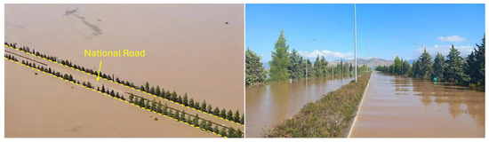
Figure 13.
Inundation of the Athens-Thessaloniki National Road due to flooding phenomena after storm Daniel (source: https://www.iefimerida.gr/, accessed on 23 December 2024).
4.4. Damage to Bridges
Hydraulic actions, such as excessive scour and debris buildup, can lead to significant damage or even collapse of bridges [5]. Storm Daniel and the subsequent flooding phenomena had a significant impact on several bridges of the road network of the affected area. Road and pedestrian bridges were severely damaged or even collapsed, leading to traffic disruptions and significant downtime for networks that are normally used by thousands of residents.
4.4.1. Road Bridges
Reported cases of damage or collapse were mainly attributed to the following mechanisms:
- Scour at the foundations of the piers, which led to settlements and/or rotations of the piers and, subsequently, movements of the deck or even partial collapses of the deck.
- Scour at the area around an abutment of the bridge, mainly in the form of breaching of the approach embankment. In some cases, the extent of this damage was so severe that it led to the abutment’s collapse, which in turn triggered the collapse of the supported deck section.
- Structural damage to the wing walls of the abutments of bridges due to soil erosion or scouring at the foundation level of such elements.
- Structural damage to the decks of bridges due to the accumulation of debris or due to impact from heavy rock blocks that were moving together with the extreme flow of major streams during the storm.
Scouring Phenomena at the Foundation of Bridge Piers
The following reported cases of damage are related to the first mechanism of failure presented above, i.e., scour at the foundations of piers.
Palaiopyrgos bridge over Pineios River connects Palaiopyrgos with Alexandrini, the coastal villages of the Municipality of Tempi (Figure 14). The four-span bridge has a width of roughly 10.0 m and a length of 120.0 m and is supported by three multi-column piers (i.e., P1, P2 and P3) and abutments (A1, A2). The piers are most probably supported by surface foundations. The significant discharge of Pineios River during and after the storm (Figure 14b) resulted in significant scouring at the foundation of pier P2 of the middle bridge, which led to the collapse of the foundation of the pier and collapse of the supporting spans (Figure 14c,d). The damage led to traffic disruption, with a significant effect on the local community.
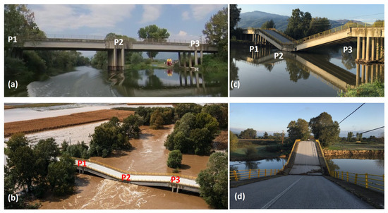
Figure 14.
Palaiopyrgos bridge over Pineios River in Larissa Region (a) before the storm (source: Google Earth; date: May 2022); (b) after storm Daniel and the collapse of pier P2 (source: https://magnesianews.gr/, accessed on 23 December 2024); and (c,d) one month after the storm (source: personal archive).
Diava bridge is a road bridge over Pineios River that connects villages located in the northwest of Trikala Region with the town of Kalambaka. Figure 15b presents a view of the bridge before storm Daniel. Constructed in 1982, the bridge has a total length of 252.0 m and a deck width of 7.5 m. The deck consists of nine girder spans with a length of 28.0 m each. Each span is formed by three prestressed rectangular-section slab girders, with cross beams at the ends and in the middle of the span. The deck structure is supported by eight wall-shaped piers (P1 to P8) and two abutments (A1–A2), which consist of concrete walls and wind walls. With the exception of one pier, the intermediate piers are founded via surface foundations with dimensions of 6.6 m × 5.0 m, whereas for the abutments, the surface foundations have dimensions 9.0 m × 6.5 m.
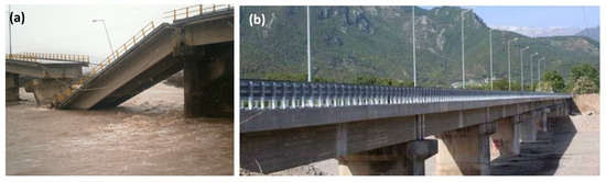
Figure 15.
Diava bridge: (a) collapse of pier P4 due to heavy rainfall in January 2016; (b) view of the restored bridge before storm Daniel (source: https://www.ert.gr/, accessed on 20 December 2024).
In January 2016, after several hours of heavy rainfall, pier P4 of the bridge collapsed due to scour at its foundation level. In particular, the pier rotated around its axis parallel to the flow direction, at about 30° to the vertical, with the axis of rotation being close to the neck of the foundation footing. The collapse of the pier resulted in the collapse of a section of the bridge deck, which led to traffic disruption (Figure 15a). After this event, the bridge was restored. Pier P4 was restored by building a new pier on a deep pile foundation and restoring the spans that collapsed. In order to reduce the vulnerability of the bridge piers and abutments against scouring phenomena, short pile diaphragms were constructed upstream and downstream in a close distance from the foundations of these elements. The bridge was functionally upgraded by changing the elastomeric bearings at the bearing positions of the superstructure beams on the piers, restoring the expansion joints at the beginning and end of the bridge, introducing parapets and constructing a steel pedestrian bridge that was anchored at the transverse concrete beams of the existing road bridge deck. The riverbed and the embankments at the sides of the river were also restored. In order to improve the riverbed in the area of the bridge, gabion boxes were introduced upstream and downstream at a distance of about 35 m from the bridge’s longitudinal axis. The rehabilitated bridge before storm Daniel is shown in Figure 15b.
The intense and long-lasting rainfall from the beginning of storm Daniel (i.e., 4 September 2023) led to a significant concentration and flow of water at the location of the bridge. Figure 16a,b illustrate the significant water volume that flowed with high speed at the site of the bridge on 6 September 2023, with no concentration of flow being observed at any pier of the bridge. At a later time on that date, torrential flow appears at the upstream end of the gabion bed, as well as around the piers of the bridge (Figure 16c). The severe flood phenomenon, associated with water flowing at high speed, eventually caused some of the gabion boxes to break, leading to flow concentrations in the area around the foundations of piers P2 and P3 (Figure 16d). This led to significant erosion of the riverbed, as well as to soil liquefaction, most probably in the form of ‘soil boiling’ at the foundations of piers P2 and P3, subsequently resulting in settlements and rotations of the foundations of these piers (Figure 16e). These settlements and rotations finally led to settlement of the spans supported by the affected piers (Figure 16e,g). Figure 16f presents the riverbed at the area of the bridge after the storm, highlighting the collapse of a large number of gabion boxes that were set in the riverbed, as well as the significant erosion of the soil underlying the gabion boxes. The settlements and rotations of the foundations of the affected piers led to significant damage of the elastomeric bearings supporting the affected deck sections, as well as minor structural damage on top of the piers and to the supporting areas of the beams of the affected deck sections (i.e., spalling of concrete cover or minor damage to the steel reinforcement). Figure 17 summarizes the reported bridge damage after the storm.
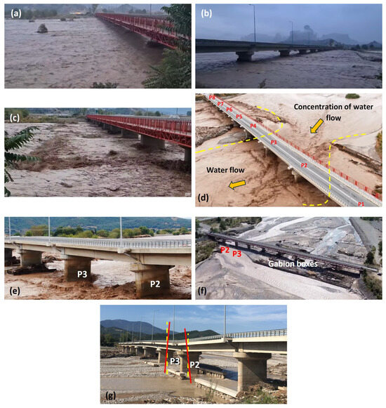
Figure 16.
Diava bridge crossing over Pineios River at various times during and after storm Daniel: (a) flow of water upstream of Diava bridge on 6 September 2023 (source: Youtube channel meteorafmnews, https://www.youtube.com/watch?v=eZe_FeABQaA, accessed on 20 December 2024); (b) flow of water downstream of Diava bridge on 6 September 2023 (source: Youtube channel meteorafmnews, https://www.youtube.com/watch?v=eZe_FeABQaA, accessed on 20 December 2024); (c) torrential flow of water upstream of the bridge on 6 September 2023 (source: Youtube channel kalabakacity, https://www.youtube.com/watch?v=4_x9XMGymy0, accessed on 20 December 2024); (d) concentration of water flow in the area around piers P2 and P3 on 7 September 2023 (Youtube channel: stagonnews, https://www.youtube.com/watch?v=STnZHT-bDoU, accessed on 20 December 2024); (e) settlement and rotation of bridge piers P2 and P3 due to soil liquefaction near the end of the storm (Youtube channel: stagonnews, https://www.youtube.com/watch?v=STnZHT-bDoU, accessed on 20 December 2024); (f) aerial view of Diava bridge after storm Daniel (source: https://www.kalabakacity.gr/, accessed on 20 December 2024); (g) settlement and rotation of bridge piers P2 and P3 due to soil liquefaction a few weeks after the storm (source: personal archive).
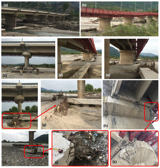
Figure 17.
Damage reported to elements of Diava bridge after storm Daniel: (a) downstream view of the bridge; (b) upstream view of the bridge; (c) pier P4 along with its pile cap remaining intact after the storm; (d) view of the caps of the pile walls, upstream and downstream of the bridge pier foundations, constructed during the rehabilitation work that took place after the partial collapse of the bridge in 2016; (e) rotation and settlement of bridge pier P3; (f,g) damage to the cap of the pile wall downstream of bridge pier P2; (h,k) structural damage (spalling of concrete) on top of bridge pier P2; (i,j) damage to the cap of the pile wall upstream of bridge pier P3 (source: personal archive).
Scouring Phenomena at the Foundation of Bridge Abutments
The following reported cases correspond to damage of bridges associated with scour phenomena around one of the abutments of each bridge, mainly in the form of breaching of the approach embankment, associated with high water flow speed.
Abelias bridge is part of the main road connecting the town of Farsala with the city of Volos, crossing Enipeas River (Larissa Region). The deck (with a length around 90.0 m and a width around 8.0 m) is supported by four girder beams, which are in turn supported by wall-type piers (two middle piers) and wall-type abutments. Similar to the previous case, the high discharge of water that flowed along the side of the bridge at high speed led to significant scouring phenomena on the left side of the riverbank (on the left when looking upstream), as well as on the left approach embankment of the bridge. The phenomena were so severe that they led to the collapse of the left abutment of the bridge (Figure 18), and subsequently to the collapse of the deck section supported by this abutment. The severity of the damage led to traffic disruption for several months. As a solution to temporarily restore the functionality of the road, an Irish crossing was constructed downstream of the bridge (Figure 18e).
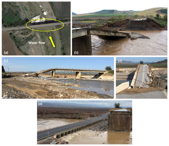
Figure 18.
Abelias bridge in Larissa Region: (a) aerial view of the bridge before storm Daniel (reference date: May 2022; source: Google Maps, accessed on 19 December 2024); (b) collapse of the left approach embankment, the left abutment and the supporting span after the storm (source: https://www.naftemporiki.gr/, accessed on 19 December 2024); (c,d) collapse of the left approach embankment, the left abutment and the supporting span a month after the storm (source: personal archive); (e) construction of an Irish crossing in August 2024 to temporarily restore the functionality of the road (source: https://www.onlarissa.gr/, accessed on 19 December 2024).
Bellegrino bridge is a road bridge near Kala Nera village that connects the villages of South Pelion with the city of Volos in Magnesia Region. Figure 19 presents a view of the bridge before storm Daniel. The bridge, which passes over a local stream, consists of two spans with a length of around 29.0 m each and a width of around 12.0 m. Each span is formed by three prestressed rectangular-section beams. The deck is supported by a three-column pier of cylindrical shape connected via a cross beam on top and two abutments, each supported by three columns of cylindrical shape. The pier and abutments are presumed to be supported by deep pile foundations. A road intersects perpendicular to the main road downstream of the bridge (Figure 19a). The storm led to significant water discharge that flowed with very high speed in the area of the bridge. This resulted in extensive scour phenomena on the side of the left abutment of the bridge (on the left when looking upstream). The phenomena were so extensive that they led to the erosion and removal of a significant volume of the approach embankment as well as of the ground both upstream and downstream. The damage caused by the soil washout led to the collapse of the road above the embankment (Figure 19b). Sadly, a moving car that was on this part of the road fell into the stream (Figure 19b). Figure 19c presents the extent of the damage in the area of the bridge. It is worth noting that the bridge abutment was not damaged by the phenomenon. The overall damage led to significant traffic disruption, affecting all villages of South-East Pelion. To recover the functionality of the road (at least to some extent), a Bailey-type bridge (i.e., a portable prefabricated steel truss bridge) was initially installed, followed by the construction of an Irish crossing on the upstream side of the road bridge. These systems remained till the reconstruction of the embankment and the riverbanks, which took place a few months later.
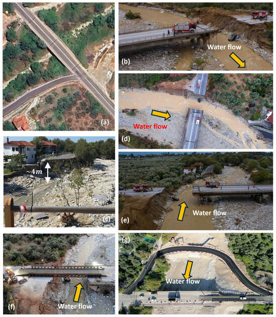
Figure 19.
Bellegrino bridge at Kala Nera in Magnesia Region: (a) aerial view of the bridge before storm Daniel (source: Google Maps, reference date: May 2022, accessed on 23 December 2024); (b–e) views of the damage on the left bank of the stream and the approach embankment of the left abutment of the bridge after storm Daniel (source: https://magnesianews.gr/, accessed on 23 December 2024); (f) installation of a Bailey bridge to temporarily recover the functionality of the road after storm Daniel; (g) construction of an Irish crossing on the upstream portion of the bridge to temporarily recover the functionality of the road after storm Daniel (source: https://magnesianews.gr/, accessed on 23 December 2024).
Ksirias bridge consists of two parallel bridges passing over Ksirias stream. The bridges form the deck for two lanes of the main road (with a total width of around 10.0 m and a length of around 60.0 m) connecting the town of Almyros with several villages in the area of Magnesia Region (Figure 20). Both bridges consist of three spans, with each one supported by reinforced concrete girders. The older bridge (on the downstream side) is supported by two wall-type piers and wall-type abutments, whereas the newer bridge (on the upstream side) is supported by cylinder-column piers and two cylinder-column abutments. The foundation system of both bridges was not identified.
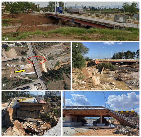
Figure 20.
Ksirias bridges in Almyros town in Magnesia Region: (a) view of the new bridge on the upstream side before the canalization works (reference date: May 2022; source: Google Maps, accessed on 23 December 2024); (b) aerial view of the bridges before storm Daniel; (c,d) damage on the left approach embankment of the bridges after the storm (source: personal archive); (e) collapse of the span of the old bridge (on the downstream side) due to the collapse of the supporting abutment after storm Daniel (source: personal archive).
Prior to storm Daniel, canalization works took place in the area of the bridge to improve the flow of water in the stream. The works included the construction of a concrete slab and pavement made of gabion boxes (on the upstream side) in the area of the bridge, as well as the construction of protection walls (reinforced concrete walls and walls made of gabion boxes) on both banks of the stream to regulate the flow of water in the bridge area. It appears that, during the storm, a significant discharge of water was concentrated in the area of bridge, resulting in flooding of the areas behind these walls, with the water flowing at very high speed. This led to significant scouring phenomena on the left approach embankment of the bridges (on the left when looking upstream) that ultimately resulted in the collapse of the abutment of the old bridge (Figure 20). This case is quite characteristic of the severity of the storm and the subsequent flooding phenomena in the area. Despite the fact that canalization works were in place before the storm, these were found to be inadequate to withstand the extreme discharges and the high-speed flow at the bridges’ location, highlighting the need for re-evaluating the design values of discharges and flow speed values for canalization works in the area. The approach embankment was reconstructed after a few months, allowing for partial restoration of the functionality of the main road (only one traffic lane was reopened).
The Aspres Petaloudes bridge, located on the west side of Volos city (Magnesia Region), crosses over Kaliakoudas stream. The bridge was near completion at the time that the storm hit the area. The relatively low height of the bridge, in addition to the floating objects (trees, branches, roots, garbage, etc.) and debris that were transported by the significant water flow in the stream, led to the accumulation of debris on the bridge, blocking passage, and subsequently leading to overflow of the water in the area of the bridge. This ultimately led to flooding of neighboring buildings, as well as significant soil erosion on the banks of the stream and behind the wing walls of the bridge (Figure 21).
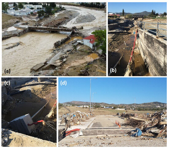
Figure 21.
Aspres Petaloudes bridge in Volos, Magnesia Region. (a) aerial view of the bridge after the storm (source: https://magnesianews.gr/, accessed on 23 December 2024); (b,c) soil erosion behind the left wing wall of the bridge after the storm; (d) remaining debris and garbage on the parapets of the deck of the bridge after the storm (source: personal archive).
Structural Damage on Bridge Decks from Rock Impacts
Two cases of bridge decks being damaged during storm Daniel from impacts with rocks were reported. Both bridges are located on the northeast side of Mt. Pelion, with both crossing main streams originating from the top of the mountain and emptying into the Aegean Sea. The paths of the streams are so steep that small waterfalls form along them. Structural damage to the bridge decks in both cases was caused by impacts with huge rocks originating upstream. Details are given below for each bridge case.
The first case is a narrow road bridge crossing a stream from Mt. Pelion’s east side, also known as Galanorema stream (Greek, meaning “blue stream”). The bridge is part of the main road network which connects several villages of Mt. Pelion with the main village of Zagora. The bridge deck has a span that measures approximately 17.0 m, while its width is around 6.0 m. The deck consists of a monolithic reinforced concrete structure: a thick slab is connected with three main girders, which are simply supported at their ends. The two abutments of the bridge are made of either concrete or masonry. The construction date of the bridge is estimated to be around 1960, when commonly reinforced concrete was used for these types of bridges (i.e., not prestressed concrete). The historic record-high precipitation values recorded in Zagora village near the bridge (1095.6 mm in 4 days) agree with the complete transformation of topography observed in the region, which is clearly visible when comparing Figure 22a,b. It is estimated that, from less than 10.0 m wide, the stream reached a width of at least 25.0 m during the storm in the area of the bridge. A large amount of large and heavy rocks were moved with the flow from upstream and eventually became stuck in the area of the bridge due to the relatively short opening below the bridge. The discharge values were so extreme that some of the rocks were found to be sitting on the road next to the bridge, as illustrated in Figure 22c,d. It is worth noting that the abutments of the bridge remained intact because they are built on solid rock. However, the bridge deck was damaged from an impact with one of the large rocks moving at high speeds. More specifically, the main girder of the deck looking upstream was crushed around its middle length (Figure 22e), resulting in buckling of the steel reinforcement at the bottom of the girder (Figure 22f,g) and complete degradation of the concrete at a length of around 4.0 m (Figure 22g). Damage on the bridge deck resulted in significant downgrading of the load rating by authorities (from 40 t to just 15 t). Considering the vital importance of this bridge for the local community, downgrading of the load rating resulted in significant traffic disruption.
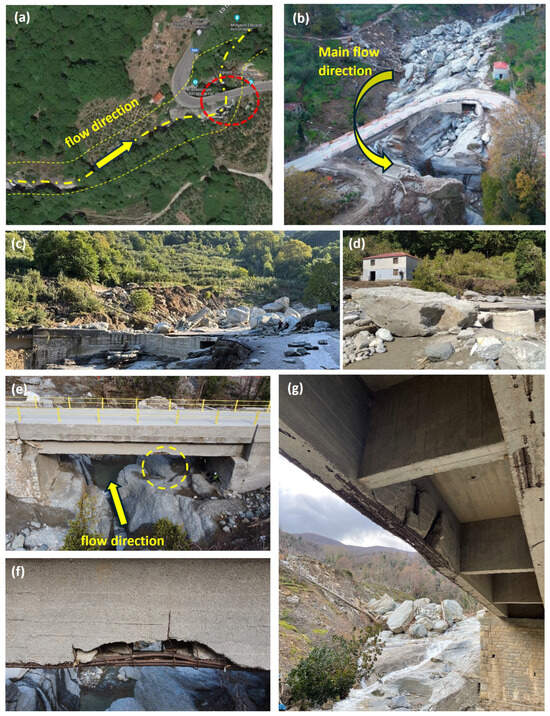
Figure 22.
Structural damage to Galanorema bridge, which is located on the east side of Mt. Pelion: (a) satellite image of Galanorema bridge before storm Daniel (source: Google Earth; date of image 13 May 2020); (b) drone image of Galanorema bridge one week after storm Daniel; (c,d) rock blocks on top of the road after the storm; (e–g) damage to the bridge girder facing upstream (source: personal archive).
Similar to the first case but on a smaller scale, the second case refers to a narrow bridge (Figure 23a) crossing a stream from Mt. Pelion known as Mega Rema stream (Greek, meaning “large stream”). This bridge is part of the main road network that connects the village of Tsagkarada with the northern villages of Mt. Pelion, as well as the city of Volos. It is located near Kissos village and is known for the waterfalls forming right above it. Hence, it is also called Kissos Waterfalls bridge. The bridge deck has a span that measures approximately 10.0 m, while its width is around 6.0 m. As in the previous case, the bridge deck experienced an impact with a large rock coming from upstream at high speed, resulting in permanent deformation of the bridge deck, which was moved from its original position as a rigid body. In fact, the rock got stuck under the bridge, as shown in Figure 23b. To partially recover the functionality of the road, a Bailey-type bridge was installed within a few days after the end of the phenomenon.
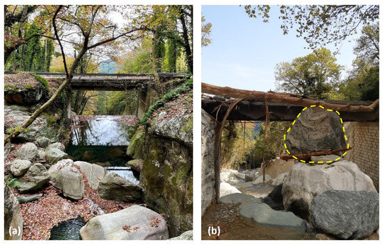
Figure 23.
Kissos Waterfalls bridge at Mt. Pelion (a) prior to storm Daniel and (b) after storm Daniel (source: personal archive).
Damage to the Wing Walls of Bridges
In several cases, damage was reported on the wing walls of bridges (Figure 24). This type of damage was mainly attributed to erosion of the backfill material behind the wing walls or scouring phenomena at the foundations of these elements. The level of damage was dependent on the discharge and debris that flowed through each bridge area and the topography of the surrounding area. It is believed that in cases of small bridges at Mt. Pelion (Figure 24a,b), the water and debris flowed over the decks of the bridges, amplifying the damage to these elements.
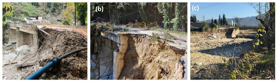
Figure 24.
(a) Makrirachi bridge at Mt. Pelion; (b) Pouri bridge at Mt. Pelion; (c) the bridge at ‘Larisis’ street crossing Kaliakouda stream (source: personal archive).
4.4.2. Historical Bridges
The Sarakinas bridge is located next to Sarakina village in Trikala Region and bridges Pineios River (Figure 25). Prior to storm Daniel, the bridge served the provincial network, connecting the villages of Sarakina and Diava. The bridge was constructed in 1520 and in its original form had six arches. The second arch (with reference from the southern end) was the largest one; i.e., with a width of 19.70 m, a height of 9.70 m and a wall thickness of 0.80 m. Only three arches of the old stone bridge had survived by the time of the storm. In 1970, all wooden parts were replaced by concrete parts, while the deck was widened by 2.0 m, allowing for the addition of sidewalks but also for the passage of wheeled vehicles. Before the storm, the bridge had a width of 5.20 m and a total length of 120.0 m. The flooding phenomena associated with the heavy rainfall in the mountains of the northwest area of Trikala Region resulted in movement of the foundations of the piers supporting the largest arch of the bridge, ultimately leading to its collapse (Figure 25b). It is worth noting that the bridge is located close to Diava (only 5 km downstream of Pineios River), which was also damaged during the flooding event (see Section 4.4.1).
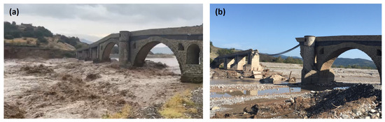
Figure 25.
Sarakinas bridge in Trikala Region (a) during the storm (source: https://www.skai.gr/, accessed on 22 December 2024) and (b) after the collapse of the largest arch caused by the flooding that resulted from storm Daniel (source: personal archive).
4.4.3. Pedestrian Bridges
Several pedestrian bridges collapsed or were damaged due to the flooding phenomenon that took place during and after storm Daniel. Severe damage or even collapse was mainly caused by the accumulation of water flow and debris in the areas of the bridges, resulting in significant dragging and uplifting forces on the decks of the bridges. The following paragraphs summarize representative cases of damaged pedestrian bridges.
Agia Paraskevi bridge is a suspension footbridge crossing over Pineios River at Tempi Valley (Larisa Region). Constructed in 1960, the bridge has a main suspended span supported by two pylons and abutments (Figure 26). The significant water discharge in the bridge area resulted in severe damage to the bridge; i.e., one of the suspension cables of the bridge collapsed, leading to the partial collapse of the deck. The severity of the flooding in the area is highlighted by the water level at the location of the bridge, which is estimated to have risen to 18.0 m above the riverbed. The bridge has not been repaired or rehabilitated yet.
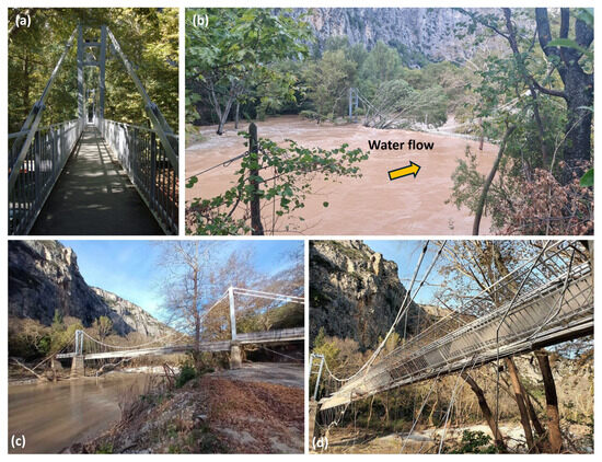
Figure 26.
Agia Paraskevi footbridge at Tempi Valley in Larissa Region: (a) view of the bridge prior to the flooding; (b) view of the bridge during the flooding; (c) view of the bridge after the flooding; (d) the collapsed deck of the bridge (source: https://www.tinealarissa.gr/, accessed on 22 December 2024).
Damage ranging from minor structural damage (Figure 27a,b) to total collapse—i.e., the washing away of a bridge (Figure 27c)—was reported with respect to pedestrian bridges crossing Krafsidonas River in the city of Volos (Magnesia Region). The damage was mainly associated with extreme water flow and debris accumulation at the locations of the bridges, which, as mentioned, led to significant dragging and uplifting forces on the bridges. Similar damage modes were reported for footbridges crossing streams in Chorto and Milina villages in East Pelion (Magnesia Region) (Figure 28). In the case of Milina, the bridge was washed into the sea (Figure 28b).
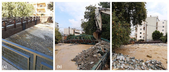
Figure 27.
Footbridges crossing over Krafsidonas stream in the city of Volos: (a,b) minor damage to the bridges due to debris accumulation; (c) a footbridge washed away by the flood (source: personal archive).
Figure 28.
Damage to footbridges crossing streams in (a) Chorto village and (b) Milina village (source: personal archive).
4.5. Landslides and Soil Erosion
The heavy rainfall and subsequent flooding led to numerous landslides and soil erosion phenomena, particularly in the mountainous regions of the affected area, such as Mt. Pelion in Magnesia Region. These landslides were triggered by factors including significant soil saturation, which weakened the soil’s strength, soil liquefaction and slope erosion that compromised ground stability. Another mechanism contributing to flood-induced landslides was the blockage of rivers or streams by debris, such as rocks and fallen trees, causing pressure to build up, resulting in a sudden flood release that could trigger a landslide. The landslides that occurred in the affected areas led to various types of damage to the road network, ranging from reduced settlement of the road pavement (Figure 29a) to total collapse of the road (Figure 29c).
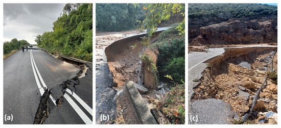
Figure 29.
Distinct types of damage to the road network in Mt. Pelion due to soil erosion and landslides: (a) settlement of the road in Lampinou; (b) the road in Ali Meria, Volos; (c) the road connecting Milina village to Trikeri village (source: Region of Thessaly).
Figure 30 presents some representative cases of significant damage to the road network in the western part of Magnesia Region. In most cases, tdamage occurred in areas where the road crossed a major or a minor stream. Figure 31 shows significant soil erosion at Iolkou Street, connecting the city of Volos with the villages of Portaria and Makrinitsa in Mt. Pelion. The street at this location runs parallel with Krafsidonas River. Given the importance of this road, efforts to temporarily restore the functionality of the road were implemented immediately after storm Daniel (Figure 31c,d). It is worth noting that during storm Elias, significant soil erosion was reported again in the area due to the severity of the flooding phenomenon, as well as due to poor compaction of the backfill material used to repair the road after the first storm. Figure 32 presents views of a severe landslide that occurred at the road connecting the villages of Portaria–Makrinitsa, in the western part of Pelion Mountain. The extent of the landslide is indicative of the severity of the heavy rainfall. Significant damage due to rainfall- or flood-induced landslides was reported on the road network of the eastern part of Mt. Pelion (Figure 33 and Figure 34). The extent of the damage in some cases is consistent with the historical rainfall recorded in the area. It is worth noting that in locations of the road network where measures were taken prior to the storm to support the ground, e.g., by constructing pile walls, vulnerability with respect to storm- or flood-induced damage was highly reduced.
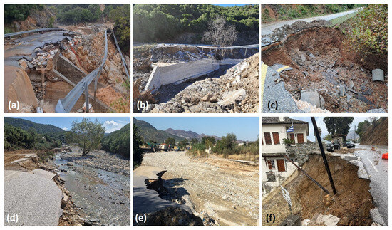
Figure 30.
Damage to the road network due to soil erosion reported after storm Daniel: (a) the road connecting Almyros to Tzournakio; (b) the road to Anthotopos; (c) the road connecting Almyros to Vrinena; (d) the road connecting Kanalia to Kerasia; (e) the road crossing the stream in Volos; (f) the road to Portaria, Volos (source: personal archive).
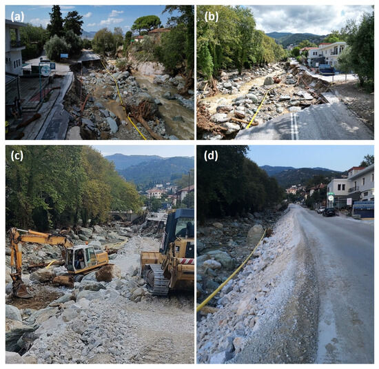
Figure 31.
(a,b) Significant erosion at Iolkou Street connecting the city of Volos with the villages of Portaria and Makrinitsa in Mt. Pelion; (c,d) temporary recovery of the road after the storm. (source: personal archive).
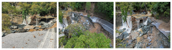
Figure 32.
Views of the severe landslide that occurred at the road connecting the villages of Portaria–Makrinitsa, in the western part of Mt. Pelion (source: Region of Thessaly).
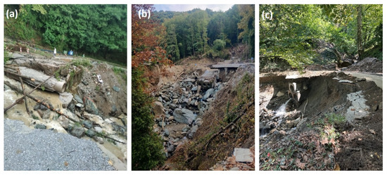
Figure 33.
Significant soil erosion of the road network near Anilio village in Mt. Pelion, (a–c): various views of damage on the road (source: Region of Thessaly).
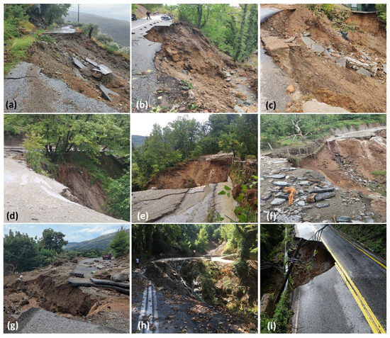
Figure 34.
Damage to the road network in Mt. Pelion due to soil erosion reported after storm Daniel: (a–c) the road connecting Drakia village to Agria village; (d–f) the road connecting Drakia village to Chania village; (g) a road near Chania village; (h) a road near Anilio village; (i) the road connecting Chania village to Karavoma (source: personal archive and Region of Thessaly).
Ground erosion phenomena due to the effects of the storm may have reduced the strength of the ground and subsequently increased the potential for additional landslides after the main event. Actually, this is something that was reported frequently after previous storms in the examined region, particularly in Mt. Pelion. The use of adequate monitoring systems, such as inclinometers, in critical locations of the region (e.g., in critical sections of the road network, near villages, etc.) would assist in the identification of locations in the area most vulnerable to landslides, as well as in the prioritization of the work required to reduce the vulnerability and increase the resilience of the examined locations in each case ofstructure or system.
4.6. Damage to Public Buildings, Technical Works, Other Infrastructure and Lifelines
4.6.1. Public Buildings and Technical Works
Field investigations after storm Daniel revealed damage to schools, public buildings and technical works. In particular, damage was reported in 13 schools in Larissa Regional Unit, 22 schools in Magnesia Regional Unit, 19 schools in Trikala Regional Unit, 19 schools in Karditsa Regional Unit, and 6 schools in Fthiotida Regional Unit. A total of 30 technical works were damaged in the Regional Unit of Larissa, whereas 41 technical works revealed damage in the Regional Unit of Magnesia. In Trikala Regional Unit, 28 cases of damage were reported to technical works. In the Karditsa Regional Unit, 28 technical works experienced damage, while in the Fthiotida Regional Unit, damage was reported to 3 technical works [15]. Among the public buildings affected were department buildings of the University of Thessaly in the city of Volos, as well as in the city of Trikala.
4.6.2. Railway Network
Flooding phenomena caused severe damage to the railway network of the affected area. A total of 180 km of the railway network was affected, including 50 km of the double line on the Athens–Thessaloniki axis, 50 km of the Larissa–Volos section and 80 km of the Palaiofarsalos–Kalambaka section. Two interlocking centers in Domokos and Palaiofarsalos were also damaged (Figure 35). Damage was reported to rail tracks, rail ties, track beds, catenary masts, cabling and electromechanical systems comprising signaling systems. The most common damage to the railway network included the erosion of the material beneath the rails and subsequent rail deformation. Additionally, various network components, such as rails, signaling systems, traffic lights and cabling, were displaced. Mud deposition and covering of tracks were also reported. A part of the railway network in the area of Domokos suffered the most from the flood generated due to storm Daniel. The railway line on the Athens–Thessaloniki axis affected by the storm was partially recovered months after the event, with one of the two lines being functional. Additional work is foreseen to repair all the damage, including the replacement of damaged elements (e.g., embankments, sleepers and rail tracks, signals, etc.).
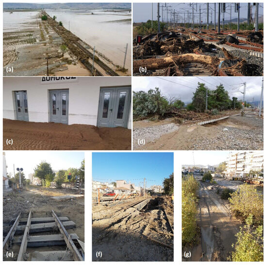
Figure 35.
Damage to the railway network in (a) the Larissa area (source: https://www.makthes.gr/, accessed on 28 December 2024), (b–d) the Domokos area (source: https://www.makthes.gr/, accessed on 28 December 2024) and (e–g) the city of Volos (source: personal archive).
4.6.3. Other Infrastructure and Lifelines
Plastiras Lake, Smokovo Lake and Karla Lake are the main artificial dams and reservoirs in Thessaly Region, having significant water storage capacities. Plastiras Lake and Smokovo Dam played a vital role in mitigating the impact of the floods induced by storm Daniel. Plastira Lake received over 50 million cubic meters of water, raising its level by 2.6 m, which helped protect the surrounding area. Meanwhile, Smokovo Dam contributed to safeguarding the Sofades settlement from the severe effects of flooding [15]. Karla Lake is located southeast of the city of Larissa, near the northern slopes of Mt. Pelion, on the border between the Larissa and Magnesia Regional Units. It was partially drained in 1962. The original lake covered an area of 180,000 to 195,000 acres and had a depth of 4.0 to 6.0 m. After the end of the storm, the water levels of the lake began to rise again, as vast amounts of water that flooded the Thessaly plain were drained through Pineios River into the lake. As a result, Karla Lake regained its original pre-1962 size, and even expanded, covering an area of 190,000 square kilometers [15].
Damage was reported to the electricity distribution network as well as to telecommunication networks [15]. The water distribution network of the city of Volos was severely damaged in several suburbs, leading to shortages for several days.
5. Discussion and Conclusions
The loss of lives, as well as the extent and severity of the damage reported after storm Daniel in the broader area of Thessaly Region, highlighted the effects of climate change on the built environment. According to reports in the press [18], initial estimates regarding repair costs ranged from €1.5 to €2 billion. New estimates from the central government led to an increase in the repair cost to €5 billion, i.e., 2.5% of Greece’s 2023 GDP, highlighting the scale of the destruction. This cost includes the more than 200,000 support requests by individual citizens and businesses seeking help, farmers’ compensation, the suspension of business tax obligations, repairs to damaged infrastructure, as well as the development of new infrastructure to mitigate future flooding risks and the development of a new water management agency that will focus on strategies to prevent further crises in the region [16].
In many cases, damage to the elements or systems mentioned above was caused by the severe intensity of the storm and the subsequent flooding. Additionally, factors such as aging of the components or systems, as well as suboptimal designs that do not meet the current ’requirements’ imposed by the examined hazards, also played a role in the extent of the reported damage. It is evident that several aspects of the geotechnical and structural design of new structures and infrastructure should be reconsidered. There is a need to update norms and regulatory provisions in order for the designs of new structures to be resistant to the effects of hazards. With reference to the assessment of existing structures and elements of the built environment, it is important to estimate accurately the hazard intensity and the vulnerability of the examined elements against the examined geohazards [19]. To estimate the vulnerability of elements at risk, tools that correlate the damage potential of the examined element with the intensity of the geohazard should be employed. Such tools, commonly provided in the form of fragility functions [5,8], may not always capture all aspects of the response of an element against the examined hazards. An indicative example is that of the fragility assessment of bridges against flood-induced damage to the approaching embankments. Even though this is a rather common form of damage, limited fragility functions are found in the literature [5,8]. Vulnerability assessments should include aspects that affect the element’s response, such as the location and topography of the areas of the examined structure, geotechnical conditions, the design and construction quality of the structure and potential aging phenomena and maintenance of the structure [20,21].
Finally, the following aspects may contribute to increasing the resilience of the built environment against geotechnical-induced damage caused by floods or severe storms: (i) flood-resistant designs for new elements of the built environment based on good knowledge of soil foundation conditions; (ii) updates to codes and relevant legislation to account for extreme hazard intensities imposed by climate change; and (iii) adaptive measures and continuous monitoring, accounting for climate change projections and infrastructure health.
Author Contributions
Conceptualization, G.T. and L.K.; methodology, G.T. and L.K.; investigation, G.T. and L.K.; data curation, G.T. and L.K.; writing—original draft preparation, G.T. and L.K.; writing—review and editing, G.T. and L.K.; visualization, G.T. and L.K. All authors have read and agreed to the published version of the manuscript.
Funding
This research received no external funding.
Data Availability Statement
Data will be provided upon request.
Acknowledgments
The authors acknowledge the Regional Unit of Magnesia in the Region of Thessaly for kindly providing part of the material related to landslides presented in this paper.
Conflicts of Interest
The authors declare no conflicts of interest.
References
- Pescaroli, G.; Alexander, D. Critical infrastructure, panarchies and the vulnerability paths of cascading disasters. Nat. Hazards 2016, 82, 175–192. [Google Scholar] [CrossRef]
- Centre for Research on the Epidemiology of Disasters (CRED). EM-DAT—The International Disaster Database. Available online: https://public.emdat.be/ (accessed on 27 December 2024).
- Kirby, A.M.; Roca, M.; Kitchen, A.; Escarameia, M.; Chesterton, O.J. Manual on Scour at Bridges and Other Hydraulic Structures, 2nd ed.; CIRIA Report C742; CIRIA: London, UK, 2015. [Google Scholar]
- Zhang, X.; Song, J.; Peng, J.; Wu, J. Landslides-oriented urban disaster resilience assessment—A case study in Shen Zhen, China. Sci. Total Environ. 2019, 661, 95–106. [Google Scholar] [CrossRef] [PubMed]
- Argyroudis, S.A.; Mitoulis, S.A.; Winter, M.G.; Kaynia, A.M. Fragility of transport assets exposed to multiple hazards: State-of-the-art review toward infrastructural resilience. Reliab. Eng. Syst. Saf. 2019, 191, 106567. [Google Scholar] [CrossRef]
- Collings, J.; Steele, M.; Wilkes, D.; Ashurst, D.; Harvey, B. Investigation into Highway Bridge Damage and Failures During the November 2009 Cumbria Flood; Forensic Engineering: Informing the future with lessons from the past; ICE Publishing: London, UK, 2013. [Google Scholar]
- Zurich Insurance Group and JBA Trust. Flooding After Storm Desmond. 2015. Available online: https://zcralliance.org/resources/item/flooding-after-storm-desmond (accessed on 17 February 2025).
- Argyroudis, S.; Mitoulis, S.A.; Hofer, L.; Zanini, M.A.; Tubaldi, E.; Frangopol, D.M. Resilience assessment framework for critical infrastructure in a multi-hazard environment: Case study on transport assets. Sci. Total Environ. 2021, 714, 136854. [Google Scholar] [CrossRef] [PubMed]
- Lehmkuhl, F.; Schüttrumpf, H.; Schwarzbauer, J.; Brüll, C.; Dietze, M.; Letmathe, P.; Völker, C.; Hollert, H. Assessment of the 2021 summer flood in Central Europe. Environ. Sci. Eur. 2022, 34, 107. [Google Scholar] [CrossRef]
- Korswagen, P.A.; Harish, S.; Oetjen, J.; Wüthrich, D. Post-Flood Field Survey of the Ahr Valley (Germany): Building Damages and Hydraulic Aspects; Delft University of Technology: Delft, The Netherlands, 2022. [Google Scholar] [CrossRef]
- Lekkas, E.; Mavroulis, S.; Mavrouli, M.; Gogou, M. The late October 2024 Valencia (Spain) Extreme Weather Events and Floods. Newsletter of Environmental, Disaster and Crises Management Strategies. 2024. Available online: https://edcm.edu.gr/en/newsletter-en/newsletter-31-the-late-october-2024-valencia-spain-extreme-weather-events-and-floods-eng (accessed on 17 February 2025).
- Lekkas, E.; Nastos, P.; Cartalis, C.; Diakakis, M.; Gogou, M.; Mavroulis, S.; Spyrou, N.-I.; Kotsi, E.; Vassilakis, E.; Katsetsiadou, K.-N.; et al. Impact of Medicane “IANOS” (September 2020). Newsletter of Environmental, Disaster and Crises Management Strategies. 2020. Available online: https://edcm.edu.gr/images/docs/newsletters/Newsletter_20_2020_Ianos.pdf (accessed on 27 December 2024).
- Diakakis, M.; Mavroulis, S.; Filis, C.; Lozios, S.; Vassilakis, E.; Naoum, G.; Soukis, K.; Konsolaki, A.; Kotsi, E.; Theodorakatou, D.; et al. Impacts of Medicanes on Geomorphology and Infrastructure in the Eastern Mediterranean, the Case of Medicane Ianos and the Ionian Islands in Western Greece. Water 2023, 15, 1026. [Google Scholar] [CrossRef]
- Mavroulis, S.; Mavrouli, M.; Lekkas, E.; Tsakris, A. Impact of the September 2023 Storm Daniel and Subsequent Flooding in Thessaly (Greece) on the Natural and Built Environment and on Infectious Disease Emergence. Environments 2024, 11, 163. [Google Scholar] [CrossRef]
- Lekkas, E.; Diakakis, M.; Mavroulis, S.; Filis, C.; Bantekas, Y.; Gogou, M.; Katsetsiadou, K.-N.; Mavrouli, M.; Giannopoulos, V.; Sarantopoulou, A.; et al. The Early September 2023 Daniel Storm in Thessaly Region (Central Greece). Newsletter of Environmental, Disaster and Crises Management Strategies. 2024. Available online: https://edcm.edu.gr/images/docs/newsletters/Newsletter_30_2024_Daniel_Thessaly.pdf (accessed on 27 December 2024).
- Dimitriou, E.; Efstratiadis, A.; Zotou, I.; Papadopoulos, A.; Iliopoulou, T.; Sakki, G.-K.; Mazi, K.; Rozos, E.; Koukouvinos, A.; Koussis, A.D.; et al. Post-Analysis of Daniel Extreme Flood Event in Thessaly, Central Greece: Practical Lessons and the Value of State-of-the-Art Water-Monitoring Networks. Water 2024, 16, 980. [Google Scholar] [CrossRef]
- Koutsoyiannis, D.; Iliopoulou, T.; Koukouvinos, A.; Malamos, N.; Mamassis, N.; Dimitriadis, P.; Tepetidis, N.; Markantonis, D. Production of Maps with Updated Parameters of the Ombrian Curves at Country Level (Implementation of the EU Directive 2007/60/EC in Greece); Technical Report; Department of Water Resources and Environmental Engineering—National Technical University of Athens: Athens, Greece, 2023; Available online: https://www.itia.ntua.gr/2273/ (accessed on 28 December 2024).
- Kathimerini Newspaper. Available online: https://www.ekathimerini.com/economy/1260156/latest-storm-daniel-damage-estimate-reaches-e5-billion/2025 (accessed on 17 February 2025).
- Karatzetzou, A.; Stefanidis, S.; Stefanidou, S.; Tsinidis, G.; Pitilakis, D. Unified hazard models for risk assessment of transportation networks in a multi-hazard environment. Inter. J. Disaster Risk Red. 2022, 75, 102960. [Google Scholar] [CrossRef]
- Huang, Z.-K.; Zhang, D.; Pitilakis, K.; Tsinidis, G.; Huang, H.; Zhang, D.; Argyroudis, S. Resilience assessment of tunnels: Framework and application for tunnels in alluvial deposits exposed to seismic hazard. Soil Dyn. Earthq. Eng. 2022, 162, 107456. [Google Scholar] [CrossRef]
- Tsinidis, G.; Karatzetzou, A.; Stefanidou, S.; Markogiannaki, O. Developments in seismic vulnerability assessment of tunnels and underground structures. Geotechnics 2022, 2, 209–249. [Google Scholar] [CrossRef]
Disclaimer/Publisher’s Note: The statements, opinions and data contained in all publications are solely those of the individual author(s) and contributor(s) and not of MDPI and/or the editor(s). MDPI and/or the editor(s) disclaim responsibility for any injury to people or property resulting from any ideas, methods, instructions or products referred to in the content. |
© 2025 by the authors. Licensee MDPI, Basel, Switzerland. This article is an open access article distributed under the terms and conditions of the Creative Commons Attribution (CC BY) license (https://creativecommons.org/licenses/by/4.0/).