Abstract
The expansion of algaroba (Neltuma juliflora), an invasive exotic species widely adapted to arid and semi-arid environments, has caused significant ecological and geomorphological changes on the northern coast of Rio Grande do Norte in Brazil. This study aimed to analyze the greening process associated with the expansion of algaroba in the Rosado Dunes Environmental Protection Area (APADR) between 2004 and 2024. Images from the SPOT 5PSM, CBERS 4, and CBERS 4A satellites were used, processed by supervised classification in QGIS software version 3.38. The multitemporal analysis revealed a significant change in the landscape, with a reduction in areas of native vegetation (caatinga and restinga) and an increase in dunes and beaches, urban areas, and invasive species. The area occupied by algaroba expanded from 70 ha (0.5%) in 2004 to 435 ha (3.1%) in 2024, representing an increase of more than six times in two decades. This expansion has had direct impacts on biodiversity, sediment dynamics, and groundwater availability, in addition to compromising connectivity between the dunes and the beach environment. The results point to the need for public policies aimed at controlling invasive species and sustainably managing native vegetation, with a view to conserving biodiversity and the integrity of the coastal and semi-arid geosystems of APADR.
1. Introduction
Algaroba (Neltuma juliflora) is a species native to Central America, but it adapts well to various arid and semi-arid environments in different parts of the world. It was introduced in Brazil in 1942, in the municipality of Serra Talhada, in the state of Pernambuco, and in the state of Rio Grande do Norte, in the municipality of Angicos, in 1946 and 1948, with seeds brought from Peru and Sudan [1,2].
According to Patnaik et al. [3], Neltuma juliflora has advantages and disadvantages, as it can be a source of fuel, food, cosmetics, biopesticides, among others. On the other hand, it has invasive development, which can bring toxins to mammals and facilitate the proliferation of mosquitoes, among other negative effects [3].
Among the positive points, we can highlight its excellent characteristics as a forage plant, in addition to being an efficient source of firewood and charcoal, and its remarkable resistance to drought, thus being able to meet the food demands of local herds during periods of drought, thereby contributing to the reduction in the impacts caused by drought [4]. Algaroba is a highly palatable forage with high nutritional values in its pods, being used as food for various animals (quails, laying hens, horses, pigs, fish, and ruminants) [5,6].
Although it has potential for animal feed, its use should be moderate, as the leaves of algaroba contain chemical compounds that reduce its palatability for animal consumption and can also cause digestive disorders, such as constipation and even death in cattle, as observed in different countries [7].
The species has a high germination rate and is resistant to different types of temperature, humidity, and water quality. In addition, it has allelopathic characteristics, meaning it releases substances that hinder the development of other species [3].
This dominant characteristic allows it to spread increasingly, monopolizing an ecosystem [8]. Invasive species are harmful and difficult to manage, and little is known about their competitive form and development strategies in other environments. In addition, vigorous growth tends to contribute to higher levels of organic carbon in the soil, which helps reduce the impacts of climate change [9].
Some studies attest to the invasion of the species in various ecosystems through geoprocessing and remote sensing techniques, such as those by Huang and Asner [10], He et al. [11], Bradley [12], Rocchini et al. [13], and Peerbhay et al. [14]. In Brazil, this is no different. Some studies address the invasion and harmful effects of this species, such as the manuscripts by Pegado et al. [15], Andrade, Fabricante and Oliveira [6,16], Mendonça et al. [17], among others.
According to Vilà et al. [18], the invasion of ecosystems by exotic species often influences biodiversity, while for Linders et al. [19], the advance of the Neltuma juliflora species can decrease the development of other plant species and reduce herbaceous biomass, indirectly affecting the population of herbivorous insects. Thus, the most recent studies highlight this deterioration in biodiversity that may be caused by this species [20]. Furthermore, with the proliferation of the species, the greening process may occur, according to Gao, Kennedy & konlechner [21] and Wang et al. [22]. In South America, particularly in Brazil’s Caatinga biome, biodiversity loss is notable [16], spreading along riverbanks, devastating riparian forests and contributing to river siltation [17], creating islands of succession due to allelopathic effects on other Caatinga species, enabling their greater propagation [6].
In this sense, the loss of biodiversity is notable when there is biological invasion by a species, which will also impact geodiversity, altering the process of soil formation and sedimentary morphodynamics, among other things. This species is also commonly found on the northern coast of the state of Rio Grande do Norte, Brazil, where the semi-arid climate reaches the coast, establishing good conditions for this species to spread in the coastal environment. This becomes problematic, given that Rosado Dunes Environmental Protection Area (APADR, acronym in Portuguese) exclusively contained species from the Caatinga biome and the restinga ecotone, and that the natural species in the area are unable to compete with algaroba (Neltuma juliflora) [21,22]. From an abiotic point of view, the proliferation of the species influences the bypass of the Rosado Dunes, creating a barrier that reduces the transport of sediments from the beach.
Thus, the objective of this study was to analyze the process of variation of Land Use/Land Cover (LULC) between 2004 and 2024 and the greening process on the Brazilian Semi-Arid Coast through the expansion of algaroba (Neltuma juliflora) in the APADR, a protected area on the northern coast of the state of Rio Grande do Norte, Brazil.
The APADR, located on the semi-arid coast of northeastern Brazil, represents one of the most ecologically and geologically significant landscapes of the region. Classified as an area of relevant geological interest, the APADR exhibits remarkable geomorphological diversity, including coastal cliffs, active and stabilized dunes, estuaries, and hypersaline environments. These features create a unique mosaic of habitats that support high environmental heterogeneity and contribute to the scenic and scientific value of the territory. Beyond its geological and geomorphological prominence, the area plays a crucial role in biodiversity conservation, serving as a refuge for endemic and threatened species adapted to extreme climatic conditions. As a coastal ecotone, the area harbors a distinctive assemblage of species such as Pavonia cancellata Cav. (Malva Rasteira), Aristida adscensionis Linn. (Capim Panasco), Cnidoscolus phyllacanthus Pax & K. Hoffm. (Faveleiro), and Cereus gounellei K. Schum. (Xique-xique), among others [23,24]. According to Faustino [25], the convergence of endemic species from the northeastern hinterlands with those from coastal environments contributes to the exceptional biodiversity richness of the area. The protection of this area is therefore fundamental not only for maintaining ecological integrity and landscape diversity but also for preserving the geoheritage and natural heritage of Brazil’s semi-arid coast.
2. Materials and Methods
2.1. Study Area
The APADR is located on the northern coast of the state of Rio Grande do Norte, between the municipalities of Porto do Mangue and Areia Branca, and is mainly accessed by the RN-404 state highway (Figure 1). The area was established as an Environmental Protection Area (APA) by Decree No. 27,695 of 21 February 2018, with the aim of ensuring the conservation of ecosystems, encouraging scientific research, promoting community tourism, protecting biological diversity, among others [26].
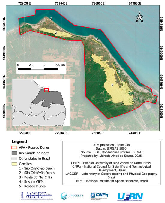
Figure 1.
Location of APADR and its geosites. Source: The authors (2025).
The area has a semi-arid climate, with average rainfall between 500 and 600 mm/year, concentrated in 3 to 4 months of rain per year [27]. The hot, dry climate has minimum temperatures above 21 °C and maximum temperatures of 32 °C, with an average annual temperature of 27.5 °C, relative humidity of around 66% (annual average) and 2400 h of sunshine per year [28].
From a geological point of view, the area is dominated by Holocene coastal aeolian deposits, ancient Pleistocene alluvial deposits and the Barreiras Formation dating from the Miocene [29]. The coastal deposits are predominantly quartz sands, while the Barreiras Formation consists of conglomerate sandstones [29]. Lithology is predominantly associated with the type of relief, with coastal plateaus occurring in the Barreiras Formation and Ancient Alluvial Deposits, while dunes and beaches occur in coastal aeolian deposits (Figure 2).
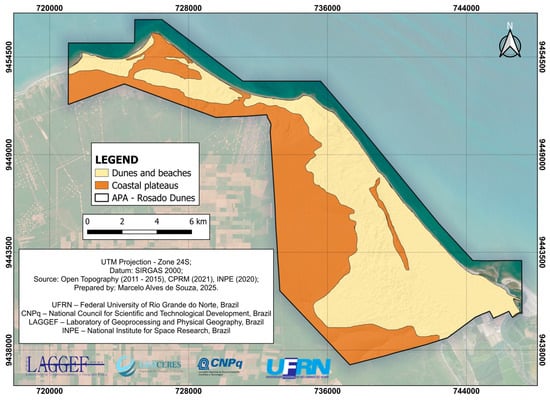
Figure 2.
Geomorphologic map of APADR. Source: The authors (2025).
In APADR, it is possible to find important geosites with scenic beauty, such as the Rosado Dunes, the Ponta do Mel Cliff, the Rosado Cliffs, among others [30]. The Rosado Dunes is a large area of shifting dunes; their formation is associated with several factors, mainly the successive processes of wind erosion, transporting sandy sediments of marine origin, and the reddish ones from the Rosado Cliffs, creating a thin red layer over the Dunes, giving them this pinkish character, with the sedimentary material of the Barreiras Formation as its source area [30] (Figure 3).
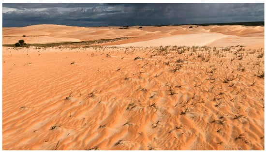
Figure 3.
Rosado Dunes Geosite. Source: The authors (2024).
The Dunas de São Cristóvão geosite (Figure 4) is predominantly composed of whitish siliciclastic material, which gives it a very different visual appearance from the Dunas do Rosado, with fewer reddish sediments and a predominance of sediments from the beach.
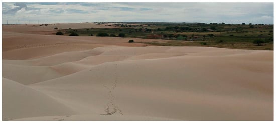
Figure 4.
São Cristóvão Dunes Geosite. Source: The authors (2024).
The area has beaches with marine sediments that are considerably flat and low [31]. Next to the beach are cliffs where Quaternary tectonics raised the sandstones of the Barreiras Formation [32], as in the São Cristóvão Beach geosite (Figure 5).
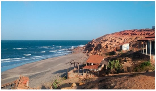
Figure 5.
São Cristóvão Beach geosite. Source: The authors (2024).
The Rosado Cliffs geosite (Figure 6) consists of inactive cliffs located along the coastline, superimposed on the Afonso Bezerra fault, not exceeding 15 m in height [32]. They have many ravines, which enhances the dissection of the relief. In addition, the top has more friable material, allowing for more intense action by rain and wind erosion agents.
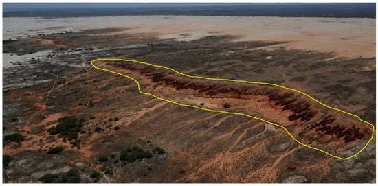
Figure 6.
Rosado Cliffs Geosite. The yellow line outlines the main escarpment of the Rosado Cliffs [33]. Source: The authors (2024).
The Ponta do Mel Cliffs geosite (Figure 7) is considered an inactive cliff, so there is no marine or fluvial erosion at the foot, with dune formations in the foothills, resulting from wind action associated with low rainfall. The area exceeds 80 m in height and is also quaternary tectonic, being the only tectonic relief on the Brazilian coast [32].
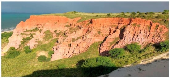
Figure 7.
Ponta do Mel Cliffs Geosite. Source: The authors (2024).
APADR is part of the potential Costa Branca UNESCO Global Geopark [32], and some geosites have been impacted by the advance of invasive species. The region has typical vegetation and is the only coastline in Brazil where the Caatinga meets the coastal environment of the sandbanks. In this coastal ecotone, the sandbanks occupy sandy Quaternary plains, forming a mosaic with diverse phytophysiognomies [23]. In addition to the sandbank and mangrove swamp with halophytic species, the area is home to two subtypes of caatinga, one being sparse hyperxerophytic shrub-tree and the other open hyperxerophytic caatinga, with species such as Jurema (Mimosa verrucosa Benth), Pinhão Bravo (Jatropha pohliana Muell), Pereiro (Aspidosperma Pirifolium), Xique-xique (Cereus Gounellei K. Schum), and Marmeleiro (Croton Hemiargyreus Muell), which occupy the coastal plains predominantly and rarely in quartzarenic deposits, where sandbank grasses predominate [24].
Brazil’s coastal zone is highly diversified due to its geomorphological and, above all, climatic variety [34], marking an ecotonal area. In addition, sandbanks are distributed along the Brazilian coastline over approximately 470,000 hectares, of which about 69% are protected by law as areas for sustainable use or integral protection. The history of land use and occupation in the study area, as well as in the Brazilian semiarid region, is marked by the widespread practice of free-range livestock grazing. During prolonged drought periods, it becomes difficult to meet the animals’ nutritional demands under confined conditions. Moreover, the free-ranging system entails lower costs for feed and infrastructure.
2.2. Methodological Procedure
The work was carried out in four stages: (i) bibliographic survey and fieldwork; (ii) satellite image research; (iii) preparation of cartographic material; and (iv) analysis of the spread of the invasive species. The bibliographic survey was conducted using different sources, such as Web of Science, Google Scholar, and Scopus, to survey the state of the art on the subject, as well as the study area. The bibliographic survey provided insight into the species, such as the works of Ribaski et al. [2], Mbaabu et al. [35], Patnaik, Abbasi and Abbasi [3], Mendonça et al. [17], as well as the trajectory of the species in the northeast, with the works of Cunha and Gomes [1], Mendonça et al. [17], works that deal with the effects and consequences of the species, such as that of Câmara et al. [5], Howari et al. [20], works that address the study area, such as that of IDEMA [24,28], Rabelo et al. [30], Diniz, Terto and Silva [32], among others. The aim is to characterise the study area and understand the behaviour of the species, its effects and consequences of its implementation, dissemination, etc.
During field expeditions to the study area, photographic surveys were conducted to visually record the landscapes and their elements. Field activities were essential for validating the mapping. The field activity was intended to familiarise participants with the study area and verify the data obtained and interpreted in the GIS environment regarding the dissemination and establishment of algaroba in APADR. The fieldwork was carried out between 12 and 13 May 2025.
Subsequently, image searches were carried out through the National Institute for Space Research (INPE). Images from different decades were searched to highlight the increase in the invasive species in the study area. The images obtained are from 2004 to 2024 from the CBERS and SPOT 5PSM systems, with image 1 from 2004, image 2 from 2016, image 3 from 2020, and image 4 from 2024 (Figure 8). Image 1 from 2004 was acquired and is included in the database of the Geoprocessing Laboratory at UFRN; the other images are free and obtained from the INPE portal. All images were taken between July and December, which marks the driest period on the northern coast and highlights the greenish tone of the invasive plant in APADR in relation to the brown and gray tones of the sandbank vegetation and caatinga, which lose their leaves during the dry season.
Image 1 from 2004 is from the SPOT 5PSM satellite, with a spatial resolution of 2.50 m and was purchased, while the other free images are from CBERS 4 and CBERS 4A. This satellite was only sent into space in 2014. The image from 2016 has a lower spatial resolution than the more recent ones, being from CBERS 4, MUX sensor with a spatial resolution of 20 m [36]. It should be noted that the PAN sensor with 10 m of spatial resolution was already available that year; however, it was not possible to find cloud-free images in which the study area stood out. The images from 2020 and 2024 are from CBERS 4A, WPM sensor with 8-m resolution in the visible spectrum [36], which is sufficient to identify the invasive species (Table 1).

Table 1.
Information on the satellite images used in the study. Source: The authors (2025).
The images used in the study did not have the same resolution, as no CBERS 4A images were found for 2016. Therefore, we opted for CBERS 4 images, using another sensor with lower resolution (20 m), which made supervised classification more difficult. In the images from 2020 and 2024, the 8-m resolution facilitated classification, being sufficient to identify the invasive species and not requiring image fusion (pansharpening) or the use of other satellites, such as Landsat. Image 1 was purchased already fused with a 5-m PAN image and another multispectral image with four 10-m bands, generating an image with 2.5 spatial resolution. True colour RGB composition was adopted for the classification process.
Algaroba was identified through supervised classification using the Classification tool from Qgis software version 3.38 for each image presented in Table 1 [37]. The classification was based on three classes: Class 2 as Dunes and Beaches, Class 3 as Caatinga and Restinga, and Class 4 as algaroba. The classification was performed based on samples taken at points where there was a concentration of a given class, identifying them mainly by hue and texture. Thus, 10 samples were obtained to classify each class in the GIS environment, using the Dzetsaka: Classification tool from Qgis 3.38 [37].
The urban area and water body classes were mapped by screen vectorisation, as their identification by supervised classification presented difficulties due to the similarity of spectral behaviour with other classes.
To assess the accuracy of the classification, the confusion matrix, Overall Accuracy and Kappa index (Table 2) were generated using the Semi-Automatic Classification Plugin tool in QGis 3.38 [37].

Table 2.
Analysis of classification accuracy (2025). Source: The authors (2025).
Mapping was performed at a scale of 1:25,000, which was the most appropriate for the image with lower spatial resolution (image 2).
Thus, supervised classification was adopted in three classes and screen vectorization in the other two. The Atlantic Ocean was removed to facilitate classification, and Google Earth Pro) [38], was used in screen vectorization to aid in the identification of some elements, especially in the 2016 image. Area calculations were also performed using the QGIS Field Calculator tool to quantify the suppression or expansion of each identified class, with an emphasis on invasive species.
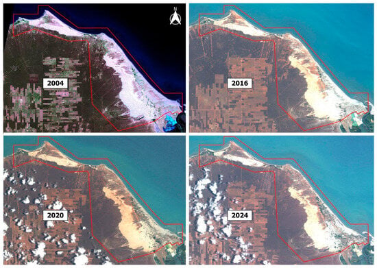
Figure 8.
Satellite images used for supervised classification, with the Rosado Dunes Environmental Protection Area (APADR) highlighted in red. Source: INPE (2025) [33,39]; The authors (2025).
3. Results
It was identified that, in 2004, the landscape of the area was dominated by caatinga and restinga, which represented 8236 hectares (59.50%). Dunes and beaches occupied 5452 hectares (39.39%), while the other classes had a negligible share: water bodies (13 ha; 0.09%), invasive species (70 ha; 0.51%), and urban areas (71 ha; 0.51%) (Figure 9). Compared to 2016, there was a sharp reduction in caatinga and sandbank areas, which fell to 7404 hectares (53.49%), resulting in a loss of approximately 832 hectares in 12 years. At the same time, there was an expansion of dunes and beaches, which increased to 6082 hectares (43.94%), indicating the advance of sandy areas over native vegetation (Figure 9).
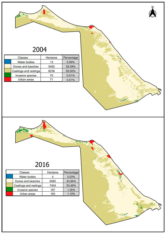
Figure 9.
Supervised classifications of images used in 2004 and 2016. Source: The authors (2025).
Another striking aspect was the growth of the urban network, which more than doubled in area, from 71 hectares (0.51%) in 2004 to 165 hectares (1.19%) in 2016, revealing a continuous process of urbanization (Figure 9). Invasive species also expanded from 70 hectares (0.51%) in 2004 to 187 hectares (1.35%) in 2016, reinforcing the trend of replacement of native areas. Water bodies, on the other hand, decreased from 13 hectares (0.09%) to only 4 hectares (0.03%), which may be associated with climate variability and reduced water availability, as these are temporary groundwater ponds that vary greatly in volume within the same year and even more so between years (Figure 9).
Multitemporal analysis of LULC between 2020 and 2024 shows significant changes in the distribution of the mapped classes (Figure 10). In 2020, the landscape was predominantly composed of caatinga and restinga, occupying 9192 hectares (66.41%). However, in 2024, this class showed a significant reduction to 7932 hectares (57.3%), indicating a loss of approximately 1260 hectares in just four years (Figure 10). In contrast, there was an expansion of dunes and beaches, which increased from 4173 hectares (30.15%) in 2020 to 5234 hectares (37.81%) in 2024. This dynamic suggests the advance of sandy areas over native vegetation, possibly associated with both natural processes and anthropogenic pressures (Figure 10). The invasive species class also showed significant growth, increasing from 281 hectares (2.03%) in 2020 to 435 hectares (3.14%) in 2024, reinforcing the trend of replacement of native vegetation by exotic species and the consequent threat to local biodiversity (Figure 10). Water bodies slightly expanded their area, from 17 hectares (0.12%) to 31 hectares (0.22%), which may be related to climate variations. Finally, there was an increase in the urban grid, which went from 181 hectares (1.31%) in 2020 to 211 hectares (1.52%) in 2024, reflecting the ongoing process of urban expansion over natural ecosystems (Figure 10).
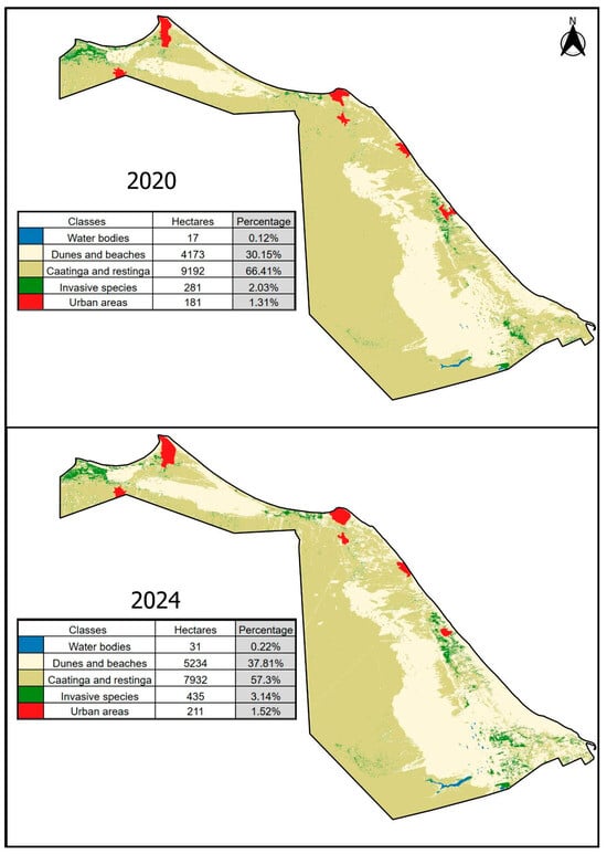
Figure 10.
Supervised classifications of images used in 2020 and 2024. Source: The authors (2025).
To verify the accuracy of the land use and occupation mappings presented in Figure 9 and Figure 10, Overall Accuracy (%) and the Kappa Index were generated, which presented positive results, proving the accuracy and reliability of the study (Table 2). The 2016 image had the lowest Overall Accuracy (98.2732%) and Kappa Index (0.9584), probably due to the low resolution of the image, which was 20 m.
4. Discussion
4.1. Analysis of Use and Occupation
Analysis of LULC between 2004 and 2024 reveals a continuous process of landscape transformation, marked above all by the retreat of the caatinga and sandbanks and the expansion of dunes and beaches, urban areas, and invasive species. In 2004, native vegetation (caatinga and restinga) was the predominant class, occupying 8236 hectares (59.50%). Over the two decades, this class has shown a consistent reduction, reaching 7932 hectares (57.30%) in 2024, which represents a loss of approximately 304 hectares compared to the beginning of the period. Although the increase is significant in absolute terms, the sharp decline between 2016 and 2020 is striking, when native coverage fell from 7404 ha (53.49%) to 9192 ha (66.41%). Even so, the overall balance points to a downward trend in the relative share of native vegetation in the landscape composition.
In contrast, dunes and beaches showed a progressive decline, decreasing from 5452 hectares (39.39%) in 2004 to 5234 hectares (37.81%) in 2024. Despite a one-off reduction in 2020 (4173 ha; 30.15%), the expansion was significant in the initial period (2004–2016) and remained relevant until the end of the time series, reinforcing the process of sandy areas advancing over vegetation. Invasive species also showed significant growth, from 70 hectares (0.51%) in 2004 to 435 hectares (3.14%) in 2024, corresponding to an increase of more than six times in two decades. This trend reveals a process of replacement of native cover by exotic species, with direct implications for biodiversity and local ecological dynamics.
The urban network expanded continuously throughout the period analyzed. In 2004, the area occupied by urban agglomerations corresponded to 71 hectares (0.51%), growing to 211 hectares (1.52%) in 2024. This threefold increase in twenty years reflects anthropogenic pressure on natural environments, especially in coastal areas, where urban expansion is most intense. Water bodies showed unstable behavior, with fluctuations over time. In 2004, they occupied 13 hectares (0.09%), reducing dramatically to only 4 hectares (0.03%) in 2016, and subsequently expanding to 31 hectares (0.22%) in 2024. This variation may be associated with climatic factors, such as periods of drought and flooding.
The reduction in caatinga and sandbank coverage is directly associated with anthropic pressure on native ecosystems, mainly due to the advance of urbanization, the opening of areas for tourist activities, and the expansion of exotic species. This decrease compromises the ecological integrity of the region, since such plant formations play a fundamental role in protecting against erosion and maintaining local biodiversity.
The expansion of dunes and beaches can be explained both by natural processes, linked to coastal sediment mobility and climatic variations, and by the suppression of vegetation that acted as a natural barrier to sand dynamics.
The significant increase in areas occupied by invasive species is one of the most worrying results, as this is an undesirable greening process, involving the suppression of native vegetation by invasive vegetation. The expansion from 0.51% of the total area in 2004 to 3.14% in 2024 suggests an accelerated process of biological invasion, which could irreversibly compromise the region’s floristic diversity and ecological stability. Invasive species often have greater adaptive and competitive capacity than native species, favoring their spread in degraded or transitional environments.
The history of land use and occupation in the study area, as well as in the Brazilian semiarid region, is marked by the widespread practice of free-range livestock grazing. During prolonged drought periods, it becomes difficult to meet the animals’ nutritional demands under confined conditions. Moreover, the free-ranging system entails lower costs for feed and infrastructure. This extensive grazing practice contributes to the biological invasion process of Neltuma juliflora, since livestock act as dispersal agents of its seeds. This can be observed in APADR, where animals raised by the local population disperse seeds in the area. From a natural point of view, dispersal occurs through the caatinga parakeet (Eupsittula cactorum), Tuim (Forpus xanthopterygius) and the eastern sea breezes. Animals and sea breezes spread Algaroba seeds, which have a high germination rate. In this context, an adverse cascading effect occurs: the herds facilitate the spread of Neltuma juliflora, which, in the long term, can cause health problems in the livestock, drive significant landscape changes, and consequently generate negative impacts on local biodiversity and geosites (geoheritage).
Over a 20-year period (2004 to 2024), algaroba increased its occupied area sixfold, from 70 hectares to 435 hectares, according to the images. This shows a very marked advance of the species, averaging approximately 18 hectares per year. It is worth highlighting the role of birds and ruminants (goats, sheep, oxen, and donkeys) that feed on the seeds contained in the pods of the species, enabling greater dispersion of the species. Another important point to mention is that the species grew by more than 150 hectares between 2020 and 2024, and by more than 210 hectares between 2004 and 2020, showing more pronounced growth from 2020 to 2024.
Due to its high adaptability to dry environments and ease of spreading, the International Union for Conservation of Nature (IUCN) has classified Neltuma juliflora, a species adapted to desert environments, as one of the most problematic invasive species on a global scale [40].
In 2004, approximately 99% of APADR was covered by natural vegetation (water bodies, dunes, beaches, caatingas, and sandbanks), by 2024, natural cover had decreased to about 95%, being suppressed mainly by invasive species (3.14% of the total area) and, secondarily, by the expansion of villages (1.52% of the total area), that is, the process of greening by invasive species is even more worrying in the protected area than human activity itself.
While algaroba is gaining ground by increasing its extent, other classes are losing ground. For example, between 2020 and 2024, the Caatinga and Restinga classes decreased from 9192 to 7932 hectares, losing about 14% in extent, which corresponds to more than 1200 hectares in the period. Of course, this was not solely due to the expansion of algaroba, which grew by just over 150 hectares, but it is likely that the invasive plant had an influence, as among the most well-known adverse effects of this species are a decrease in diversity and vegetation cover, as well as reduced availability of groundwater [8]. This influence warrants further investigation.
The class that gained the most hectares in this 4-year interval was Dunes and Beaches. Water bodies were another class that expanded, despite a decline in 2016, which was a year of prolonged drought in the area. In the rest of the images, there were increases, from 13 hectares in 2004 to 31 hectares in 2024, a year of above-average rainfall in the area. All mapped water bodies are interdune lagoons, which are exclusively groundwater lagoons; there are no rivers in APADR.
4.2. Implications of the Species Neltuma juliflora in the Study Area
The presence of the invasive plant algaroba near water bodies is notable (Figure 11), which shows that, in addition to being a species adapted to the semi-arid climate, it can also occupy swampy areas. This can be seen in Figure 9 and Figure 11, where algaroba occupies lower areas of the relief, near interdune lagoons in APADR (Figure 11). As reported by Linders et al. [19], most of the Neltuma juliflora in their study occur in dune areas at lower altitudes, even in agricultural areas and near water bodies.
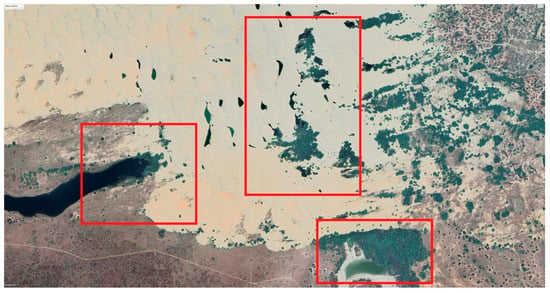
Figure 11.
Algaroba in shades of green near water bodies (darker shades). The red boxes highlight areas with concentrated Algaroba patches. Source: Google Earth (2024) [38].
At the Dunas do Rosado Geosite, the invasive species has created a kind of barrier that reduces the flow of sediment from the beach to the dune formation. If we consider the period from 2004 to 2024, the reduction was from approximately 5452 to 5234 hectares of the geosite. As can be seen in Figure 12, the Dunas do Rosado geosite has gradually lost its connection with the beach, which is the main source of sediment for the field of shifting dunes. In 2004, there were several beach-dune connections, but by 2024, the dune field had migrated further west and is now practically disconnected from the beach. Thus, the advance of invasive species and native vegetation has favored the process of losing the dunes’ connections to the beach.
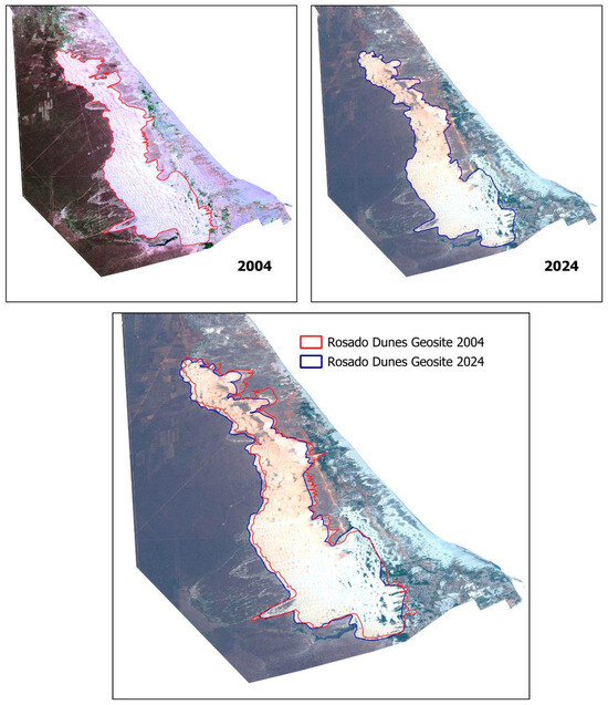
Figure 12.
Dunas do Rosado geosite losing its connections with the beach. Source: The authors (2025).
Another point to highlight is that algaroba can alter the hydrological dynamics of an area. According to Tundia, Ghosh and Chinnasamy [41], the species influenced the availability of groundwater, altering water dynamics and increasing evapotranspiration rates in India, which is consequently reflected in soil moisture.
Shiferaw et al. [42] mention in their study that the depth of the roots enables the plant to reach water reserves in the soil even in the dry season and ensures the continuity of transpiration. The study also found that the perennial species N. juliflora consumed more water and had a higher transpiration rate in the dry season than in the rainy season, and the species is known to have high water consumption. Research conducted in South Africa shows that invasive trees and hybrids of this genus significantly reduce groundwater levels due to their extremely deep axial roots [42].
This water extraction affects not only surface runoff but also groundwater recharge and evaporation rates. This species uses water throughout the year, with even higher consumption during the dry season compared to the rainy season. Thus, if the expansion of this invasive tree is not controlled and its density is not reduced in the areas where it has established itself, it is likely to have significant impacts on sustainable livelihoods in region [42].
In addition to the expansion of Neltuma juliflora, human actions such as deforestation and intensive grazing, combined with climate change, contribute to the problem. Even so, Neltuma demonstrates a greater ability to adapt to environmental changes than native plant species. This is because, thanks to its deep root system, Neltuma can survive in places where few other plants thrive. In addition, this species can directly affect the survival of native vegetation, possibly by competing for water and releasing allelopathic substances [35]. This is notable in other studies focused on Brazil, where the species devastates biodiversity and delays the development of native vegetation, in addition to poisoning ruminant animals through excessive consumption [15,17]. These species pose a serious environmental threat, as they can reduce or replace local biodiversity, modifying the functioning and services provided by ecosystems, and causing significant economic damage [35]. In Kenya, since 2005, the expansion of Neltuma has become more intense, leading herders to consider it responsible for the reduction in grazing areas [9].
The Rosado Dunes are marked by the presence of temporary natural interdune lagoons (Figure 13). Temporary interdune lagoons are bodies of water that form in wide, low-lying depressions located between dunes (Figure 14), usually in sandy areas associated with deflation plains and close to the water table. Their existence depends directly on the rainfall regime, being filled during the rainy season and disappearing during the dry season, when the space becomes covered by herbaceous vegetation [43].
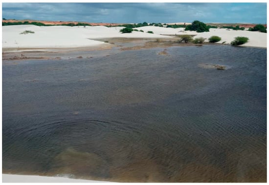
Figure 13.
Temporary natural interdune lagoons, with isolated algaroba trees on the dunes. Source: The authors (2025).
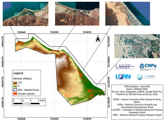
Figure 14.
Altimetric map of the Rosado Dunes APA. Source: The authors (2025).
These lagoons are characterized as seasonal wetlands that remain flooded long enough, especially during the rainy season, to allow the development of semi-aquatic or aquatic vegetation and animal communities [43]. Despite this, they are neither fully aquatic nor completely terrestrial environments, as they face extreme and unstable ecological conditions throughout the year [44]. While some temporary ponds can retain water for more than a year, others can remain dry for more than a season, depending on the amount of rainfall [45].
Isolated algaroba trees stand out on the dunes near the lagoons (Figure 12). The presence of these trees indicates a process of vegetation occupation that, while providing shade and soil stabilization, alters the natural dynamics of the dune environment.
4.3. Rural–Urban Fringe and the Introduction of Algaroba in APADR
As expected, the urban grid grew over the 20 years of the analysis, with the area increasing in all newer images compared to older ones, as did the occupation by the invasive species, from 71 to 211 hectares, with a growth of 140 hectares in the analysis period. One point to note is that there is a lot of algaroba in the urban grid (Figure 15), but this was not considered in the vectorization, since the species is found in urban areas and it is understandable that residents planted the species in some cases, making it difficult to know whether the species spread naturally or artificially in the urban area. However, in Figure 16, on the outskirts of the village of São Cristóvão, we identified large concentrations of the invasive species, which are possibly natural proliferation, although it is impossible to say for sure. Byalt et al. [46] point out that algaroba is less frequent on the streets of settlements and more frequent in gardens and vacant lots in Fujairah (UAE).
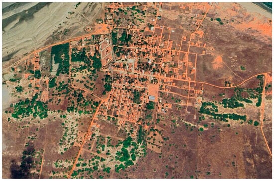
Figure 15.
Algaroba in shades of green in the urban fabric of the village of São Cristóvão. Source: Google Earth (2024) [38].
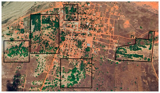
Figure 16.
Areas densely populated by the invasive species on the outskirts of the village of São Cristóvão. The black squares highlight sections with higher concentrations of the species. Source: Adapted from Google Earth (2024) [38].
The introduction of algaroba seems to have started in the small villages in APADR, as noted in Figure 17. The areas with the highest density of algaroba trees are to the west of the villages, with the exception of the algaroba trees further south in APADR, which were probably dispersed from the city of Porto do Mangue, located at the eastern end of APADR. The prevailing wind from the east seems to play a key role in dispersing seeds from the villages towards the west.
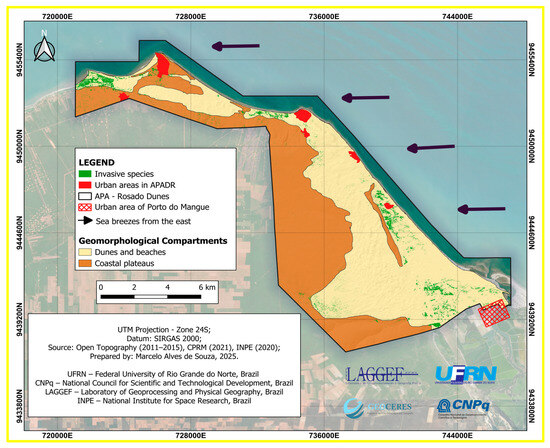
Figure 17.
Invasive species and their spread across villages. Source: The authors (2025).
In addition to this concentration and dispersion near the western sector of the villages, the species has adapted to lower-lying areas and coastal wind deposits associated with the relief of dunes and beaches, as shown in Figure 17 and Figure 18 and Table 3, 83% of the area where Algaroba occurs is on beaches and sand dunes.
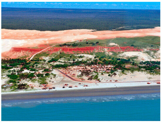
Figure 18.
Photograph of the area in 2007 at APADR. In the background, dense vegetation covers the coastal plains and consists of species native to the Caatinga biome. Grasses from the restingas grow on the dunes, and the trees with crowns are Algarobas and some coconut trees near Rosado Village. Source: HIDROSEMA Project (2007) [47].

Table 3.
Total in hectares and percentage of invasive species in each geomorphological compartment (2025). Source: The authors (2025).
According to Jackson et al. [48], the introduction of exotic species, i.e., the greening of coastal dunes, is a direct way of altering the morphology of the dunes, in addition to other activities such as deforestation and agriculture, among others. The authors add that these activities can trigger various consequences, such as changes in groundwater levels, changes in wind incidence, and even sediment supply. In the study by Xu et al. [49], dune stabilization is related to wind, as is the greening of the study area.
Of the 13,842 hectares classified, algaroba went from 70, which corresponds to only 0.5% of the area considered, to 435, which is approximately 3.1%, i.e., it grew by more than 2.5 percentage points in the study area. These figures are high compared to those for 2004, which affects the other classes analysed, except for the urban area, mainly altering the area occupied by other species in the caatinga and restinga and, in some cases, expanding to the beaches (Figure 19).
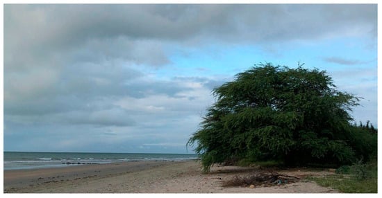
Figure 19.
Algaroba near the beach in the Rosado Dunes APA. Source: The authors (2025).
Considering the historical expansion of Neltuma juliflora between 2004 and 2024—from 70 ha (0.5%) to 435 ha (3.1%)—the species increased its occupied area by approximately 18 ha per year on average. If this trend continues under current environmental and anthropogenic conditions, Neltuma juliflora could occupy between 525 and 615 hectares within the next five years (by 2029), and approximately 700 to 800 hectares within ten years (by 2034). These projections represent a potential increase of 60–85% relative to 2024. However, if factors such as climate change, prolonged droughts, and ongoing free-range livestock grazing persist or intensify, the invasion rate could accelerate even further. The expansion would likely continue along low-lying interdune areas and near urban peripheries, where seed dispersal by livestock and birds is more intense. Without management and control measures, Neltuma juliflora may become dominant over large portions of the APADR landscape, threatening the integrity of native Caatinga–Restinga mosaics and compromising the geomorphological and ecological stability of the Rosado Dunes geosystem.
The eradication of Neltuma juliflora (algaroba) is extremely difficult; therefore, rational and integrated management represents the most viable alternative, taking advantage of the species’ potential as a natural resource [2]. Control of N. juliflora invasion can be achieved through a combination of mechanical, chemical, and biological practices. These include tree pruning, manual weeding and collection of mature pods, isolation of invaded areas to prevent direct grazing, processing of pods to feed livestock in troughs, and biological control through seed infestation by bruchid beetles [2].
To effectively address this environmental challenge, it is essential to establish partnerships between the Environmental Institute of Rio Grande do Norte (IDEMA), public authorities at the municipal and state levels, and academic and research institutions. Such cooperation should focus on joint projects aimed at identifying the full extent of the invasion in the Costa Branca area and assessing its impacts on both abiotic and biotic components of the environment.
Sustainable alternatives for the management of N. juliflora should involve strategies that simultaneously limit its invasive spread and make rational use of its resources. A combination of management methods—such as targeted mechanical control (tree cutting in selected areas), the use of pods and wood as economic resources, and ecological restoration with native species within the APADR—could serve as effective approaches for mitigating the invasion.
Moreover, community engagement is fundamental in this process. Local populations must be involved in decision-making, and their socioeconomic realities and traditional knowledge should be incorporated into management plans. It is also crucial that strategies consider the broader historical, sociopolitical, economic, and environmental contexts of the region. This participatory approach aligns with the mission of Environmental Protection Areas (APA), which aim to conserve biodiversity and natural resources while promoting the sustainable use of territory.
5. Conclusions
Monitoring of LULC between 2004 and 2024 in the Rosado Dunes APA revealed significant environmental changes, notably the reduction in caatinga and restinga areas and the growth of dunes and beaches, urban areas, and, above all, the invasive species algaroba (Neltuma juliflora).
The analysis showed that, in two decades, algaroba expanded from 70 hectares (0.5% of the total area) in 2004 to 435 hectares (3.1%) in 2024, representing an increase of more than six times. This advance occurred in both dry areas and humid and low-lying sectors of the relief, including interdune lagoons and areas close to urban environments. Its presence modifies the natural dynamics of the dunes, reduces connectivity with the beach, alters groundwater availability, and compromises local biodiversity, confirming its character as an environmental threat. This scenario may be further aggravated by climate change.
The Rosado Dunes Environmental Protection Area is undergoing a process of environmental transformation marked by natural and anthropogenic forces, but intensified by the rapid spread of algaroba. The species, considered one of the most problematic invasive species on a global scale, directly affects local biotic and abiotic dynamics and may compromise the ecological sustainability of the area.
The results of this study reinforce the need for strategies to manage and control algaroba, as well as public policies aimed at conserving native vegetation, regulating urban occupation, and continuously monitoring the environmental dynamics of APADR. Such measures are fundamental for maintaining biodiversity, ecosystem services, and the integrity of the coastal and semi-arid geosystems present in the conservation unit.
Author Contributions
Conceptualization, M.T.M.D.; methodology, M.A.d.S. and V.A.d.S.; validation, P.V.d.N.A., D.d.V.L., J.Y.G.d.S. and M.T.M.D.; formal analysis, M.T.M.D.; investigation, M.A.d.S.; resources, M.T.M.D.; data curation, M.A.d.S. and V.A.d.S.; writing—original draft preparation, M.A.d.S.; writing—review and editing, V.A.d.S.; project administration, M.T.M.D.; funding acquisition, M.T.M.D. All authors have read and agreed to the published version of the manuscript.
Funding
This research was funded by the Foundation for the Support and Promotion of Science, Technology, and Innovation in Rio Grande do Norte, the National Council for Scientific and Technological Development (CNPq), the Coordination for the Improvement of Higher Education Personnel (CAPES, finance code 001), and the Federal University of Rio Grande do Norte (UFRN), under institutional support. The APC was funded by the Foundation for the Support and Promotion of Science, Technology and Innovation in Rio Grande do Norte.
Data Availability Statement
Dataset available on request from the authors.
Acknowledgments
The authors thank the Foundation for the Support and Promotion of Science, Technology and Innovation in Rio Grande do Norte, the National Council for Scientific and Technological Development (CNPq) and the Federal University of Rio Grande do Norte (UFRN).
Conflicts of Interest
The authors declare no conflicts of interest.
References
- Cunha, L.H.; Gomes, R.A. The trajectory of algaroba in the northeastern semi-arid region: Political and scientific dilemmas. Raízes J. Soc. Econ. Sci. 2012, 32, 72–95. [Google Scholar] [CrossRef]
- Ribaski, J.; Drumond, M.A.; Oliveira, V.R.D.; Nascimento, C.E.D.S. Algaroba (Prosopis juliflora): A Tree with Multiple Uses for the Brazilian Semi-Arid Region; EMBRAPA: Colombo, Brazil, 2009; pp. 1–7. Available online: https://www.infoteca.cnptia.embrapa.br/infoteca/bitstream/doc/661908/1/CT240Prosopis.pdf (accessed on 13 September 2025).
- Patnaik, P.; Abbasi, T.; Abbasi, S.A. Prosopis (Prosopis juliflora): Blessing and bane. Trop. Ecol. 2017, 455–483. Available online: https://www.researchgate.net/publication/322682224_Prosopis_Prosopis_juliflora_Blessing_and_bane (accessed on 17 September 2025).
- Trenchard, L.J.; Harris, P.J.; Smith, S.J.; Pasiecznik, N.M. Review of ploidy in the genus Prosopis (Leguminosae). Bot. J. Linn. Soc. 2008, 156, 425–438. [Google Scholar] [CrossRef]
- Câmara, A.C.L.; Costa, N.D.A.; Riet-Correa, F.; Afonso, J.A.B.; Dantas, A.F.; Mendonça, C.L.D.; Souza, M.I.D. Spontaneous poisoning in cattle by mesquite beans, Prosopis juliflora (Leg. Mimosoideae) in Pernambuco. Pesqui. Veterinária Bras. 2009, 29, 233–240. [Google Scholar] [CrossRef]
- Santos, J.P.S.; Diodato, M.A. History of algaroba implementation in Rio Grande do Norte. Braz. For. Res. 2017, 37, 201–212. [Google Scholar] [CrossRef]
- Mwangi, E.; Swallow, B. Invasion of Prosopis juliflora and Local Livelihoods: Case Study from the Lake Baringo Area of Kenya; ICRAF Working Paper no. 3; World Agroforestry Centre: Nairobi, Kenya, 2005; pp. 1–66. [Google Scholar] [CrossRef]
- Knüsel, S.; Conedera, M.; Rigling, A.; Fonti, P.; Wunder, J. A tree-ring perspective on the invasion of Ailanthus altissima in protection forests. For. Ecol. Manag. 2015, 354, 334–343. [Google Scholar] [CrossRef]
- Eschen, R.; Bekele, K.; Mbaabu, P.R.; Kilawe, C.J.; Eckert, S. Prosopis juliflora management and grassland restoration in Baringo County, Kenya: Opportunities for soil carbon sequestration and local livelihoods. J. Appl. Ecol. 2021, 58, 1302–1313. [Google Scholar] [CrossRef]
- Huang, C.Y.; Asner, G.P. Applications of remote sensing to alien invasive plant studies. Sensors 2009, 9, 4869–4889. [Google Scholar] [CrossRef]
- He, K.S.; Rocchini, D.; Neteler, M.; Nagendra, H. Benefits of hyperspectral remote sensing for tracking plant invasions. Divers. Distrib. 2011, 17, 381–392. [Google Scholar] [CrossRef]
- Bradley, B.A. Remote detection of invasive plants: A review of spectral, textural and phenological approaches. Biol. Invasions 2014, 16, 1411–1425. [Google Scholar] [CrossRef]
- Rocchini, D.; Andreo, V.; Förster, M.; Garzon-Lopez, C.X.; Gutierrez, A.P.; Gillespie, T.W.; Hauffe, H.C.; He, K.S.; Kleinschmit, B.; Mairota, P.; et al. Potential of remote sensing to predict species invasions: A modeling perspective. Prog. Phys. Geogr. Earth Environ. 2015, 39, 283–309. [Google Scholar] [CrossRef]
- Peerbhay, K.; Mutanga, O.; Lottering, R.; Ismail, R. Mapping Solanum mauritianum plant invasions using WorldView-2 imagery and unsupervised random forests. Remote Sens. Environ. 2016, 182, 39–48. [Google Scholar] [CrossRef]
- Pegado, C.M.A.; Andrade, L.A.D.; Félix, L.P.; Pereira, I.M. Effects of the biological invasion of mesquite: Prosopis juliflora (Sw.) DC. on the composition and structure of the shrub-tree stratum of the caatinga in the municipality of Monteiro, PB, Brazil. Acta Bot. Bras. 2006, 20, 887–898. [Google Scholar] [CrossRef]
- Andrade, L.A.D.; Fabricante, J.R.; Oliveira, F.X.D. Impacts of the invasion of Prosopis juliflora (sw.) DC. (Fabaceae) on the shrub-tree stratum in Caatinga areas in the State of Paraíba, Brazil. Acta Sci. Biol. Sci 2010, 32, 249–255. [Google Scholar] [CrossRef]
- Mendonça, M.F.; Pedroso, P.M.; Pimentel, L.A.; Madureira, K.M.; Macêdo, J.T.; D’sOares, C.S.; Silva, A.W.; Peixoto, T.C. Epidemiological aspects of natural poisoning by Prosopis juliflora in ruminants in semiarid areas of the state of Bahia, Brazil, invaded by the plant. Pesqui. Veterinária Bras. 2020, 40, 501–513. [Google Scholar] [CrossRef]
- Vilà, M.; Espinar, J.L.; Hejda, M.; Hulme, P.E.; Jarošík, V.; Maron, J.L.; Pergl, J.; Schaffner, U.; Sun, Y.; Pyšek, P. Ecological impacts of invasive alien plants: A meta-analysis of their effects on species, communities and ecosystems. Ecol. Lett. 2011, 14, 702–708. [Google Scholar] [CrossRef] [PubMed]
- Linders, T.E.W.; Schaffner, U.; Eschen, R.; Abebe, A.; Choge, S.K.; Nigatu, L.; Mbaabu, P.R.; Shiferaw, H.; Allan, E. Direct and indirect effects of invasive species: Biodiversity loss is a major mechanism by which an invasive tree affects ecosystem functioning. J. Ecol. 2019, 107, 2660–2672. [Google Scholar] [CrossRef]
- Howari, F.M.; Sharma, M.; Nazzal, Y.; El-Keblawy, A.; Mir, S.; Xavier, C.M.; Salem, I.B.; Al-Taani, A.A.; Alaydaroos, F. Changes in the Invasion Rate of Prosopis juliflora and Its Impact on Depletion of Groundwater in the Northern Part of the United Arab Emirates. Plants 2022, 11, 682. [Google Scholar] [CrossRef]
- Gao, J.; Kennedy, D.M.; Konlechner, T.M. Coastal dune mobility over the past century: A global review. Prog. Phys. Geogr. Earth Environ. 2020, 44, 814–836. [Google Scholar] [CrossRef]
- Wang, L.; Qiu, Y.; Han, Z.; Xu, C.; Wu, S.-Y.; Wang, Y.; Xu, Z. Climate, topography and anthropogenic effects on desert greening: A 40-year satellite monitoring in the Tengger Desert, northern China. Catena 2022, 209, 105851. [Google Scholar] [CrossRef]
- Scarano, F.R. Structure, function and floristic relationships of plant communities in stressful habitats marginal to the Brazilian Atlantic rainforest. Ann. Bot. 2002, 90, 517–524. [Google Scholar] [CrossRef] [PubMed]
- IDEMA/RN. Atlas for the Promotion of Sustainable Investment in Rio Grande do Norte. 2014. Available online: http://adcon.rn.gov.br/ACERVO/idema/Conteudo.asp?TRAN=ITEM&TARG=1360&ACT=null&PAGE=0&PARM=null&LBL=Socioecon%C3%B4micos (accessed on 1 October 2025).
- Faustino, S.J.B. Community Perception in the Participatory Process of Creating and Managing the Dunas do Rosado-RN Environmental Protection Area. Master’s Thesis, Federal Rural University of the Semi-arid Region, Mossoró, Brazil, 2022. [Google Scholar] [CrossRef]
- Rio Grande do Norte (State). DECREE No. 27,695/2018. Published in the Official Gazette of the State of Rio Grande do Norte. 2018. Available online: http://adcon.rn.gov.br/ACERVO/gac/DOC/DOC000000000172319.PDF (accessed on 15 September 2025).
- Diniz, M.T.M.; Pereira, V.H.C. Climatology of the state of Rio Grande do Norte, Brazil: Active atmospheric systems and climate type mapping. Goiano Geogr. Bull. 2015, 35, 488–506. [Google Scholar] [CrossRef]
- IDEMA/RN. Socio-Economic Studies. Profile—Your Municipality. Porto do Mangue. Available online: http://www.idema.rn.gov.br (accessed on 1 October 2025).
- Dantas, E.P.; Medeiros, V.C.; Cavalcante, R. Mapa Geológico do Estado do Rio Grande do Norte. Recife: Serviço Geológico do Brasil—CPRM. 2021. Available online: https://rigeo.sgb.gov.br/handle/doc/22401 (accessed on 4 September 2025).
- Rabelo, T.O.; Diniz, M.T.M.; de Araújo, I.G.D.; de Oliveira Terto, M.L.; Queiroz, L.S.; Araújo, P.V.d.N.; Pereira, P. Risk of Degradation and Coastal Flooding Hazard on Geoheritage in Protected Areas of the Semi-arid Coast of Brazil. Water 2023, 15, 2564. [Google Scholar] [CrossRef]
- Diniz, M.T.M.; de Oliveira, G.P.; Maia, R.P.; Ferreira, B. Geomorphological mapping of the state of Rio Grande do Norte. Braz. J. Geomorphol. 2017, 18, 689–701. [Google Scholar] [CrossRef]
- Diniz, M.T.M.; Terto, M.L.D.O.; da Silva, F.E.B. Assessment of the geomorphological heritage of the Costa Branca area, a potential geopark in Brazil. Resources 2023, 12, 13. [Google Scholar] [CrossRef]
- LAGGEF—Laboratory of Geoprocessing and Physical Geography (UFRN). SPOT-5 PSM Image (Spatial Resolution of 2.5 m) Caicó, 2025. Satellite Image: Color. Belonging to the LAGGEF/UFRN Collection. Available online: https://regards.cnes.fr/user/swh/modules/60 (accessed on 16 November 2025).
- Ministry of the Environment. Aquatic Biodiversity and Fisheries Resources Management. Overview of Coastal and Marine Ecosystem Conservation in Brazil; MMA/SBF/GBA: Brasília, Brazil, 2010; p. 148. Available online: https://www.marinha.mil.br/secirm/sites/www.marinha.mil.br.secirm/files/mma-205_publicacao27072011042233.pdf (accessed on 2 September 2025).
- Mbaabu, P.R.; Ng, W.-T.; Schaffner, U.; Gichaba, M.; Olago, D.; Choge, S.; Oriaso, S.; Eckert, S. Spatial evolution of Prosopis invasion and its effects on LULC and livelihoods in Baringo, Kenya. Remote Sens. 2019, 11, 1217. [Google Scholar] [CrossRef]
- CBERS—China-Brazil Earth Resources Satellite. EMBRAPA. Available online: https://www.embrapa.br/satelites-de-monitoramento/missoes/cbers (accessed on 2 September 2025).
- QGIS Development Team. QGIS Geographic Information System (Version 3.34) [Software]. Open Source Geospatial Foundation. 2024. Available online: https://qgis.org (accessed on 15 April 2025).
- Google Earth Pro. Google Earth Pro (Version 7.3) [Computer Software]. Google LLC. 2024. Available online: https://earth.google.com/ (accessed on 16 November 2025).
- National Institute for Space Research—INPE. INPE Catalog. 2025. Available online: https://www.dgi.inpe.br/catalogo/explore (accessed on 2 September 2025).
- Dzikiti, S.; Schachtschneider, K.; Naiken, V.; Gush, M.; Moses, G.; Le Maitre, D.C. Water relations and the effects of clearing invasive Prosopis trees on groundwater in an arid environment in the Northern Cape, South Africa. J. Arid. Environ. 2013, 90, 103–113. [Google Scholar] [CrossRef]
- Tundia, K.; Ghosh, S.; Chinnasamy, P. Influences of Prosopis juliflora on groundwater resources in Gujarat. J. Hydrol. 2025, 662, 133993. [Google Scholar] [CrossRef]
- Shiferaw, H.; Alamirew, T.; Dzikiti, S.; Bewket, W.; Zeleke, G.; Schaffner, U. Water use of Prosopis juliflora and its impacts on catchment water budget and rural livelihoods in Afar Region, Ethiopia. Sci. Rep. 2021, 11, 2688. [Google Scholar] [CrossRef]
- Araújo, C.P.D.; Amaral, R.F.; do Nascimento Araújo, P.V. Granulometry and morphometry of coastal surface sediments: The interdune lagoon complex of the Jenipabu APA, Rio Grande do Norte, Brazil. HOLOS 2020, 6, 1–18. [Google Scholar] [CrossRef]
- Pinto-Cruz, C.; Molina, J.A.; Barbour, M.; Silva, V.; Espírito-Santo, M.D. Plant communities as a tool in temporary ponds conservation in SW Portugal. Hydrobiologia 2009, 634, 11–24. [Google Scholar] [CrossRef]
- Zacharias, I.; Dimitriou, E.; Dekker, A.; Dorsman, E. Overview of temporary ponds in the Mediterranean region: Threats, management and conservation issues. J. Environ. Biol. 2007, 28, 1–9. Available online: https://www.jeb.co.in/journal_issues/200701_jan07/paper_01.pdf (accessed on 27 September 2025). [PubMed]
- Byalt, V.V.; Korshunov, M.V. Distribution of Invasive Species Prosopis juliflora (Mimosaceae) in Fujairah (UAE). Russ. J. Biol. Invasions 2021, 12, 157–166. [Google Scholar] [CrossRef]
- HIDROSEMA Project. Cooperative Project for Monitoring Environmental Changes and the Influence of Hydrodynamic Forcing on Beach Morphology in the Serra and Macau Fields in the Potiguar Basin (HIDROSEMA Project, FINEP/PETROBRAS/CNPq). 2007. 1 photograph: Color. Image obtained during a helicopter overflight on 14 May 2007.
- Jackson, D.W.; Costas, S.; González-Villanueva, R.; Cooper, A. Global ‘greening’ of coastal dunes: An integrated consequence of climate change? Glob. Planet. Change 2019, 182, 103026. [Google Scholar] [CrossRef]
- Xu, Z.; Hu, R.; Wang, K.; Mason, J.A.; Wu, S.-Y.; Lu, H. Recent greening (1981–2013) in the Mu Us dune field, north-central China, and its potential causes. Land Degrad. Dev. 2018, 29, 1509–1520. [Google Scholar] [CrossRef]
Disclaimer/Publisher’s Note: The statements, opinions and data contained in all publications are solely those of the individual author(s) and contributor(s) and not of MDPI and/or the editor(s). MDPI and/or the editor(s) disclaim responsibility for any injury to people or property resulting from any ideas, methods, instructions or products referred to in the content. |
© 2025 by the authors. Licensee MDPI, Basel, Switzerland. This article is an open access article distributed under the terms and conditions of the Creative Commons Attribution (CC BY) license (https://creativecommons.org/licenses/by/4.0/).