
Integrated Coastal Vulnerability Index (ICVI) Assessment of Protaras Coast in Cyprus: Balancing Tourism and Coastal Risks

 , , , ,
Abstract
1. Introduction
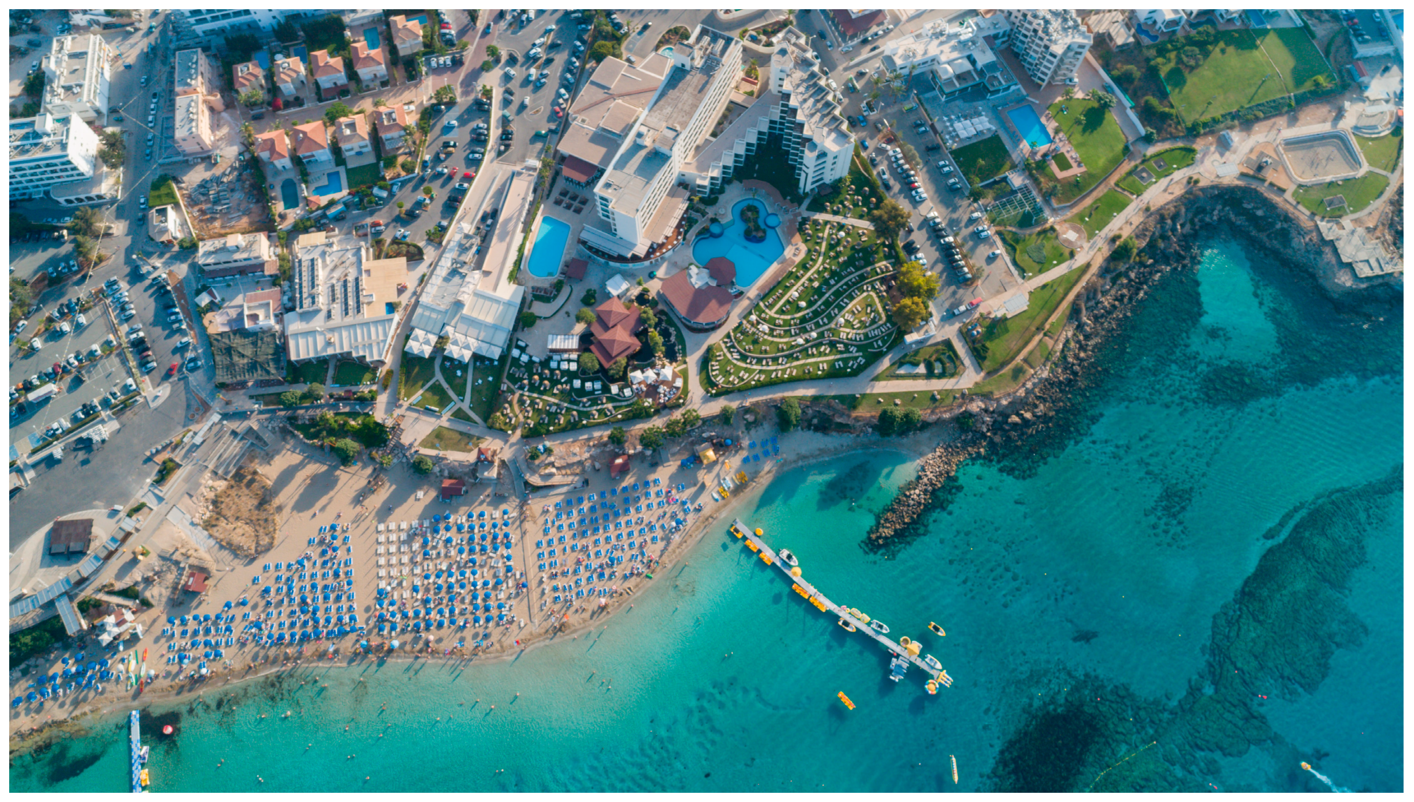
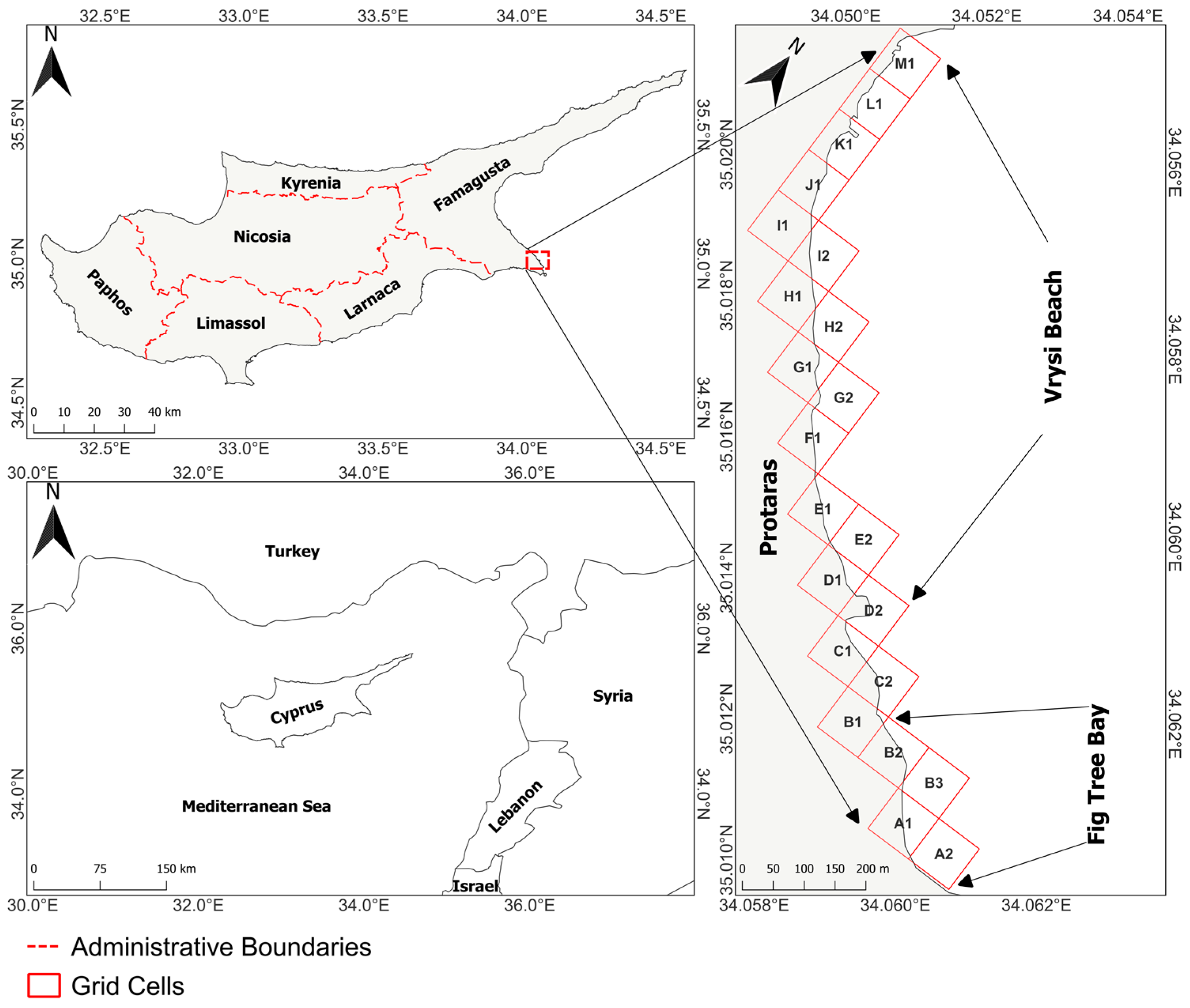
2. Study Area
3. Materials and Methods
3.1. Geological and Hydro-Physical Parameters (PVI)
3.2. Socio-Economic Parameters (SVI)
3.3. Calculation of ICVI with AHP Method
4. Results
4.1. Physical Parameters
4.2. Socio-Economic Parameters
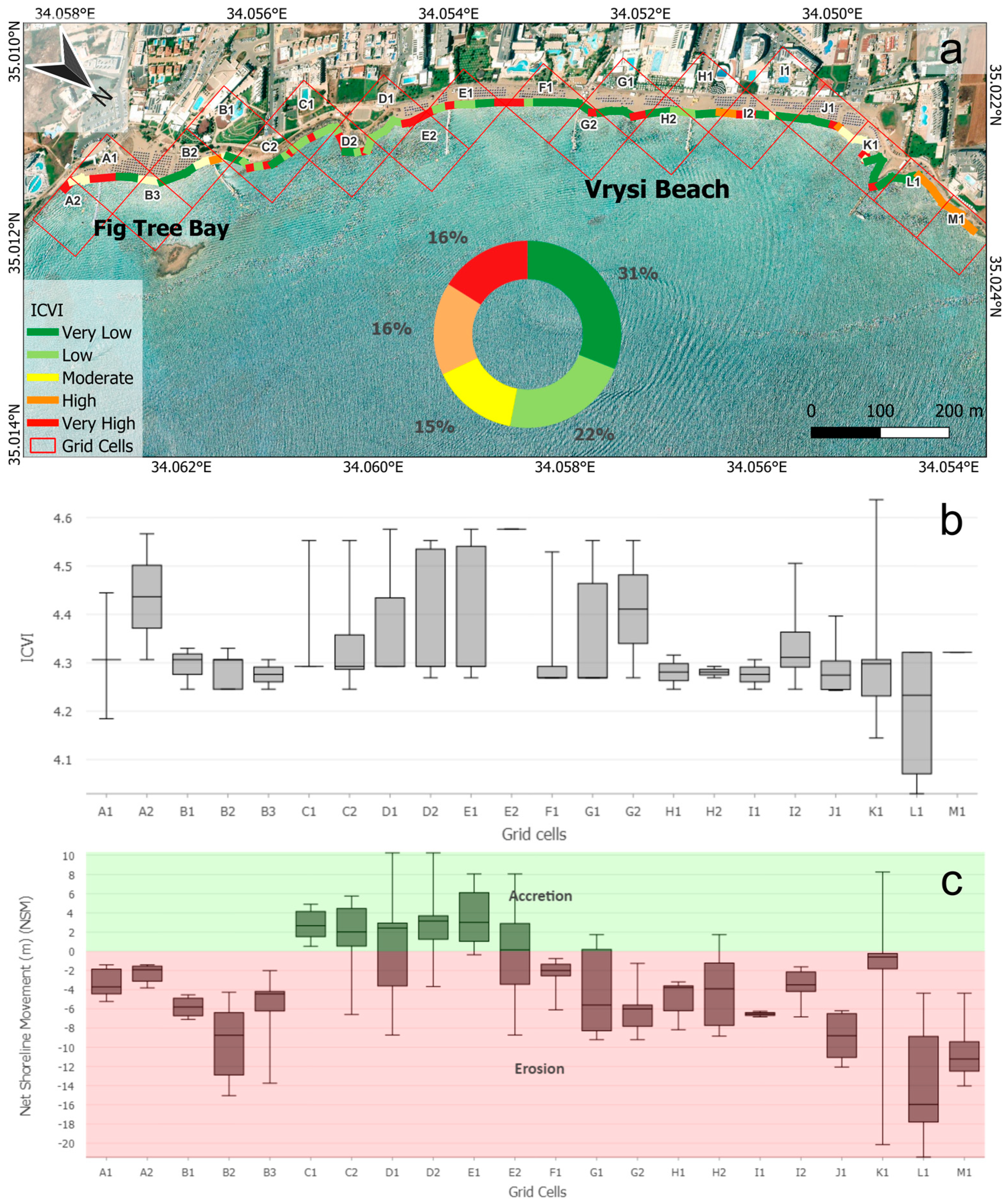
4.3. Integrated Coastal Vulnerability Index (ICVI)
5. Discussion
6. Conclusions
Author Contributions
Funding
Data Availability Statement
Acknowledgments
Conflicts of Interest
Appendix A

References
- Winarso, G.; Judijanto; Budhiman, S. The Potential Application Remote Sensing Data for Coastal Study. 2001. Available online: https://www.researchgate.net/profile/Gathot-Winarso/publication/237787781_THE_POTENTIAL_APPLICATION_REMOTE_SENSING_DATA_FOR_COASTAL_STUDY/links/5562d55d08ae8c0cab3339c6/THE-POTENTIAL-APPLICATION-REMOTE-SENSING-DATA-FOR-COASTAL-STUDY.pdf (accessed on 3 February 2025).
- Šimac, Z.; Lončar, N.; Faivre, S. Overview of Coastal Vulnerability Indices with Reference to Physical Characteristics of the Croatian Coast of Istria. Hydrology 2023, 10, 14. [Google Scholar] [CrossRef]
- Cui, B.-L.; Li, X.-Y. Coastline Change of the Yellow River Estuary and Its Response to the Sediment and Runoff (1976–2005). Geomorphology 2011, 127, 32–40. [Google Scholar] [CrossRef]
- Hossen, M.F.; Sultana, N. Shoreline Change Detection Using DSAS Technique: Case of Saint Martin Island, Bangladesh. Remote Sens. Appl. Soc. Environ. 2023, 30, 100943. [Google Scholar] [CrossRef]
- Sethuraman, S.; Alshahrani, H.M.; Tamizhselvi, A.; Sujaatha, A. Assessment of Coastal Vulnerability Using AHP and Machine Learning Techniques. J. South Am. Earth Sci. 2024, 147, 105107. [Google Scholar] [CrossRef]
- Boak, E.H.; Turner, I.L. Shoreline Definition and Detection: A Review. J. Coast. Res. 2005, 214, 688–703. [Google Scholar] [CrossRef]
- Arun Kumar, A.; Kunte, P.D. Coastal Vulnerability Assessment for Chennai, East Coast of India Using Geospatial Techniques. Nat. Hazards 2012, 64, 853–872. [Google Scholar] [CrossRef]
- Canul Turriza, R.A.; Fernández-Díaz, V.Z.; Cárdenas Rojas, D.M.; Tzuc, Ó.M. Coastal Vulnerability Assessment with a Hierarchical Coastal Segments Approach. Ocean Coast. Manag. 2024, 249, 106989. [Google Scholar] [CrossRef]
- Mahendra, R.S.; Mohanty, P.C.; Bisoyi, H.; Kumar, T.S.; Nayak, S. Assessment and Management of Coastal Multi-Hazard Vulnerability along the Cuddalore–Villupuram, East Coast of India Using Geospatial Techniques. Ocean Coast. Manag. 2011, 54, 302–311. [Google Scholar] [CrossRef]
- Zhu, Z.-T.; Cai, F.; Chen, S.-L.; Gu, D.-Q.; Feng, A.-P.; Cao, C.; Qi, H.-S.; Lei, G. Coastal Vulnerability to Erosion Using a Multi-Criteria Index: A Case Study of the Xiamen Coast. Sustainability 2018, 11, 93. [Google Scholar] [CrossRef]
- Balica, S.F.; Popescu, I.; Beevers, L.; Wright, N.G. Parametric and Physically Based Modelling Techniques for Flood Risk and Vulnerability Assessment: A Comparison. Environ. Model. Softw. 2013, 41, 84–92. [Google Scholar] [CrossRef]
- Velegrakis, A.F.; Chatzistratis, D.; Chalazas, T.; Armaroli, C.; Schiavon, E.; Alves, B.; Grigoriadis, D.; Hasiotis, T.; Ieronymidi, E. Earth Observation Technologies, Policies and Legislation for the Coastal Flood Risk Assessment and Management: A European Perspective. Anthr. Coasts 2024, 7, 3. [Google Scholar] [CrossRef]
- Deb, D.; Uddin, M.M.; Mahbub-E-Kibria, A.S.M.; Kumar Das, M.; Hasan, M. Coastal Vulnerability Assessment to Multi Hazards in the Exposed Coast of Southeastern Coastal Region of Bangladesh. Reg. Stud. Mar. Sci. 2024, 73, 103484. [Google Scholar] [CrossRef]
- Kantamaneni, K.; Xing, L.; Gupta, V.; Campos, L.C. Vulnerability Assessment of English and Welsh Coastal Areas. Sci. Rep. 2024, 14, 27467. [Google Scholar] [CrossRef]
- Gornitz, V.; White, T.W.; Cushman, R.M. Vulnerability of the US to Future Sea Level Rise; Oak Ridge National Lab.: Oak Ridge, TN, USA, 1991. [Google Scholar]
- Thieler, E.R.; Hammar-Klose, E.S. National Assessment of Coastal Vulnerability to Sea-Level Rise: Preliminary Results for the U.S. Atlantic Coast; United States Geological Survey: Reston, VA, USA, 1999. [Google Scholar]
- Pendleton, E.A.; Thieler, E.R.; Williams, S.J.; Beavers, R.L. Coastal Vulnerability Assessment of Padre Island National Seashore (PAIS) to Sea-Level Rise; US Geological Survey: Reston, VA, USA, 2004. [Google Scholar]
- Gerrity, B.; Phillips, M. Comparative Analysis of Coastal Vulnerability Indexes in Different Geographic Settings. J. Coast. Res. 2025, 113, 11–15. [Google Scholar] [CrossRef]
- Cruz-Ramírez, C.J.; Chávez, V.; Silva, R.; Muñoz-Perez, J.J.; Rivera-Arriaga, E. Coastal Management: A Review of Key Elements for Vulnerability Assessment. J. Mar. Sci. Eng. 2024, 12, 386. [Google Scholar] [CrossRef]
- Bukvic, A.; Rohat, G.; Apotsos, A.; de Sherbinin, A. A Systematic Review of Coastal Vulnerability Mapping. Sustainability 2020, 12, 2822. [Google Scholar] [CrossRef]
- Roukounis, C.N.; Tsihrintzis, V.A. Indices of Coastal Vulnerability to Climate Change: A Review. Environ. Process. 2022, 9, 29. [Google Scholar] [CrossRef]
- Arda, T.; Bayrak, O.C.; Uzar, M. Analyzing Coastal Vulnerability Using Analytic Hierarchy Process and Best–Worst Method: A Case Study of the Marmara Gulf Region. Arab. J. Sci. Eng. 2025, 50, 1851–1869. [Google Scholar] [CrossRef]
- Chapapría, V.E.; Peris, J.S.; González-Escrivá, J.A. Coastal Monitoring Using Unmanned Aerial Vehicles (UAVs) for the Management of the Spanish Mediterranean Coast: The Case of Almenara-Sagunto. Int. J. Environ. Res. Public Health 2022, 19, 5457. [Google Scholar] [CrossRef]
- Jessin, J.; Heinzlef, C.; Long, N.; Serre, D. A Systematic Review of UAVs for Island Coastal Environment and Risk Monitoring: Towards a Resilience Assessment. Drones 2023, 7, 206. [Google Scholar] [CrossRef]
- Di Paola, G.; Minervino Amodio, A.; Dilauro, G.; Rodriguez, G.; Rosskopf, C.M. Shoreline Evolution and Erosion Vulnerability Assessment along the Central Adriatic Coast with the Contribution of UAV Beach Monitoring. Geosciences 2022, 12, 353. [Google Scholar] [CrossRef]
- Minervino Amodio, A.; Di Paola, G.; Rosskopf, C.M. Monitoring Coastal Vulnerability by Using DEMs Based on UAV Spatial Data. ISPRS Int. J. Geo-Inf. 2022, 11, 155. [Google Scholar] [CrossRef]
- Marino, M.; Nasca, S.; Alkharoubi, A.I.; Cavallaro, L.; Foti, E.; Musumeci, R.E. Efficacy of Nature-Based Solutions for Coastal Protection under a Changing Climate: A Modelling Approach. Coast. Eng. 2025, 198, 104700. [Google Scholar] [CrossRef]
- Unguendoli, S.; Biolchi, L.G.; Aguzzi, M.; Pillai, U.P.A.; Alessandri, J.; Valentini, A. A Modeling Application of Integrated Nature Based Solutions (NBS) for Coastal Erosion and Flooding Mitigation in the Emilia-Romagna Coastline (Northeast Italy). Sci. Total Environ. 2023, 867, 161357. [Google Scholar] [CrossRef]
- Hasiotis, T.; Andreadis, O.; Chatzipavlis, A.; Mettas, C.; Evagorou, E.; Kountouri, J.; Hadjimitsis, D.; Christofi, D.; Loizidou, M.; Chrysostomou, G. A Holistic High-Resolution Monitoring Approach in Studying Coastal Erosion of a Highly Touristic Beach, Coral Bay, Cyprus. In Proceedings of the Ninth International Conference on Remote Sensing and Geoinformation of the Environment (RSCy2023), SPIE, Ayia Napa, Cyprus, 3–5 April 2023; Volume 12786, pp. 376–385. [Google Scholar]
- Theocharidis, C.; Doukanari, M.; Kalogirou, E.; Christofi, D.; Mettas, C.; Kontoes, C.; Hadjimitsis, D.; Argyriou, A.V.; Eliades, M. Coastal Vulnerability Index (CVI) Assessment: Evaluating Risks Associated with Human-Made Activities along the Limassol Coastline, Cyprus. Remote Sens. 2024, 16, 3688. [Google Scholar] [CrossRef]
- Bengoufa, S.; Niculescu, S.; Mihoubi, M.K.; Belkessa, R.; Rami, A.; Rabehi, W.; Abbad, K. Machine Learning and Shoreline Monitoring Using Optical Satellite Images: Case Study of the Mostaganem Shoreline, Algeria. J. Appl. Remote Sens. 2021, 15, 026509. [Google Scholar] [CrossRef]
- Trinh, L.H.; Le, T.G.; Tran, X.B.; Tran, Q.V.; Le, V.P.; To, T.P. Monitoring of Coastline Change Using Sentinel-2 MSI Data. A Case Study in Thanh Hoa Province, Vietnam. Bull. Geogr. Phys. Geogr. Ser. 2024, 26, 77–87. [Google Scholar] [CrossRef]
- Şenol, H.İ.; Kaya, Y.; Yiğit, A.Y.; Yakar, M. Extraction and Geospatial Analysis of the Hersek Lagoon Shoreline with Sentinel-2 Satellite Data. Surv. Rev. 2024, 56, 367–382. [Google Scholar] [CrossRef]
- Nazeer, M.; Waqas, M.; Shahzad, M.I.; Zia, I.; Wu, W. Coastline Vulnerability Assessment through Landsat and Cubesats in a Coastal Mega City. Remote Sens. 2020, 12, 749. [Google Scholar] [CrossRef]
- Cassidy, G.; Wiseman, M.; Lange, K.; Eilers, C.; Bradley, A. Seasonal Coastal Erosion Rates Calculated from PlanetScope Imagery in Arctic Alaska. Remote Sens. 2024, 16, 2365. [Google Scholar] [CrossRef]
- Collin, A.; James, D.; Feunteun, E. Towards Better Coastal Mapping Using Fusion Of High Temporal Sentinel-2 And Planetscope-2 Imageries: 12 Bands At 3 M Through Neural Network Modelling. Int. Arch. Photogramm. Remote Sens. Spat. Inf. Sci. 2022, XLIII-B3-2022, 479–484. [Google Scholar] [CrossRef]
- Domazetović, F.; Šiljeg, A.; Marić, I.; Faričić, J.; Vassilakis, E.; Panđa, L. Automated Coastline Extraction Using the Very High Resolution WorldView (WV) Satellite Imagery and Developed Coastline Extraction Tool (CET). Appl. Sci. 2021, 11, 9482. [Google Scholar] [CrossRef]
- Cooper, H.M.; Chen, Q.; Fletcher, C.H.; Barbee, M.M. Assessing Vulnerability Due to Sea-Level Rise in Maui, Hawai‘i Using LiDAR Remote Sensing and GIS. Clim. Change 2013, 116, 547–563. [Google Scholar] [CrossRef]
- Liu, Q.; Ruan, C.; Guo, J.; Li, J.; Lian, X.; Yin, Z.; Fu, D.; Zhong, S. Storm Surge Hazard Assessment of the Levee of a Rapidly Developing City-Based on LiDAR and Numerical Models. Remote Sens. 2020, 12, 3723. [Google Scholar] [CrossRef]
- Cooper, H.M.; Fletcher, C.H.; Chen, Q.; Barbee, M.M. Sea-Level Rise Vulnerability Mapping for Adaptation Decisions Using LiDAR DEMs. Prog. Phys. Geogr. Earth Environ. 2013, 37, 745–766. [Google Scholar] [CrossRef]
- Boumpoulis, V.; Depountis, N.; Dimas, A.; Papatheodorou, G. Presentation and Analysis of the Geotechnical Coastal Vulnerability Index and Validation of Its Application to Coastal Erosion Problems. Sci. Rep. 2025, 15, 1424. [Google Scholar] [CrossRef] [PubMed]
- Marzouk, M.; Azab, S. Modeling Climate Change Adaptation for Sustainable Coastal Zones Using GIS and AHP. Environ. Monit. Assess. 2024, 196, 147. [Google Scholar] [CrossRef]
- Saaty, T.L. The Analytic Hierarchy Process (AHP). J. Oper. Res. Soc. 1980, 41, 1073–1076. [Google Scholar]
- Araujo, J.C.; Dias, F.F. Multicriterial Method of AHP Analysis for the Identification of Coastal Vulnerability Regarding the Rise of Sea Level: Case Study in Ilha Grande Bay, Rio de Janeiro, Brazil. Nat. Hazards 2021, 107, 53–72. [Google Scholar] [CrossRef]
- Mnasri, H.; Nunes, A.; Sahnoun, H.; Abdelkarim, B.; Mahmoudi, S. Assessment of Soil Erosion in Southern Tunisia Using AHP-GIS Modeling. Euro-Mediterr. J. Environ. Integr. 2024, 9, 223–234. [Google Scholar] [CrossRef]
- Le Cozannet, G.; Garcin, M.; Bulteau, T.; Mirgon, C.; Yates, M.L.; Méndez, M.; Baills, A.; Idier, D.; Oliveros, C. An AHP-Derived Method for Mapping the Physical Vulnerability of Coastal Areas at Regional Scales. Nat. Hazards Earth Syst. Sci. 2013, 13, 1209–1227. [Google Scholar] [CrossRef]
- Martínez, M.L.; Silva, R.; Pérez-Maqueo, O.; Chávez, V.; Mendoza-González, G.; Maximiliano-Cordova, C. The Dilemma of Coastal Management: Exploitation or Conservation? Camb. Prism. Coast. Futur. 2024, 2, e10. [Google Scholar] [CrossRef]
- Andolina, C.; Signa, G.; Tomasello, A.; Mazzola, A.; Vizzini, S. Environmental Effects of Tourism and Its Seasonality on Mediterranean Islands: The Contribution of the Interreg MED BLUEISLANDS Project to Build up an Approach towards Sustainable Tourism. Environ. Dev. Sustain. 2021, 23, 8601–8612. [Google Scholar] [CrossRef]
- Geological Survey Department. Available online: https://www.moa.gov.cy/moa/gsd/gsd.nsf/dmlIndex_en/dmlIndex_en?opendocument (accessed on 7 January 2025).
- Food and Agriculture Organization of the United Nations. Available online: https://www.fao.org/home/en (accessed on 7 January 2025).
- Antonaras, A. The Cyprus Tourism Sector and the Sustainability Agenda 2030. Cyprus Rev. 2018, 30, 123–140. [Google Scholar]
- Georgiou, A. The Cyprus Tourism Sector and Its Investment Environment. Econ. Sci. 2018, 7, 202–207. [Google Scholar]
- Statista Research Department. Travel and Tourism: Share of GDP in the EU, by Country. Available online: https://www.statista.com/statistics/1228395/travel-and-tourism-share-of-gdp-in-the-eu-by-country/ (accessed on 29 January 2025).
- Hamid, A.I.A.; Din, A.H.M.; Yusof, N.; Abdullah, N.M.; Omar, A.H.; Abdul Khanan, M.F. Coastal Vulnerability Index Development: A Review. Int. Arch. Photogramm. Remote Sens. Spat. Inf. Sci. 2019, XLII-4/W16, 229–235. [Google Scholar] [CrossRef]
- De Serio, F.; Armenio, E.; Mossa, M.; Petrillo, A.F. How to Define Priorities in Coastal Vulnerability Assessment. Geosciences 2018, 8, 415. [Google Scholar] [CrossRef]
- Baig, M.R.I.; Shahfahad; Ahmad, I.A.; Tayyab, M.; Asgher, M.S.; Rahman, A. Coastal Vulnerability Mapping by Integrating Geospatial Techniques and Analytical Hierarchy Process (AHP) along the Vishakhapatnam Coastal Tract, Andhra Pradesh, India. J. Indian Soc. Remote Sens. 2021, 49, 215–231. [Google Scholar] [CrossRef]
- Lu, G.Y.; Wong, D.W. An Adaptive Inverse-Distance Weighting Spatial Interpolation Technique. Comput. Geosci. 2008, 34, 1044–1055. [Google Scholar] [CrossRef]
- Himmelstoss, E.; Henderson, R.E.; Farris, A.; Kratzmann, M.; Bartlett, M.K.; Ergul, A.; McAndrews, J.; Cibaj, R.; Zichichi, J.; Thieler, R. Digital Shoreline Analysis System (Version 6); United States Geological Survey: Reston, VA, USA, 2024. [Google Scholar]
- Tragaki, A.; Gallousi, C.; Karymbalis, E. Coastal Hazard Vulnerability Assessment Based on Geomorphic, Oceanographic and Demographic Parameters: The Case of the Peloponnese (Southern Greece). Land 2018, 7, 56. [Google Scholar] [CrossRef]
- Yahia Meddah, R.; Ghodbani, T.; Senouci, R.; Rabehi, W.; Duarte, L.; Teodoro, A.C. Estimation of the Coastal Vulnerability Index Using Multi-Criteria Decision Making: The Coastal Social–Ecological System of Rachgoun, Western Algeria. Sustainability 2023, 15, 12838. [Google Scholar] [CrossRef]
- Sayre, R.; Butler, K.; Van Graafeiland, K.; Breyer, S.; Wright, D. Ecological Coastal Units–Standardized Global Shoreline Characteristics. In Proceedings of the OCEANS 2022, Hampton Roads, VA, USA, 17–20 October 2022; pp. 1–4. [Google Scholar]
- Korres, G.; Ravdas, M.; Zacharioudaki, A.; Denaxa, D.; Sotiropoulou, M. Mediterranean Sea Waves Reanalysis (CMEMS Med-Waves, MedWAM3 System) (Version 1) 2021. Available online: https://documentation.marine.copernicus.eu/QUID/CMEMS-MED-QUID-006-012.pdf (accessed on 1 February 2025).
- Guérou, A.; Meyssignac, B.; Prandi, P.; Ablain, M.; Ribes, A.; Bignalet-Cazalet, F. Current Observed Global Mean Sea Level Rise and Acceleration Estimated from Satellite Altimetry and the Associated Measurement Uncertainty. Ocean Sci. 2023, 19, 431–451. [Google Scholar] [CrossRef]
- Bondarenko, M. Individual Countries 1 km Population Density (2000–2020); University of Southampton: Southampton, UK, 2020. [Google Scholar]
- Anfuso, G.; Postacchini, M.; Di Luccio, D.; Benassai, G. Coastal Sensitivity/Vulnerability Characterization and Adaptation Strategies: A Review. J. Mar. Sci. Eng. 2021, 9, 72. [Google Scholar] [CrossRef]
- Pendleton, E.A.; Thieler, E.R.; Williams, S.J. Importance of Coastal Change Variables in Determining Vulnerability to Sea- and Lake-Level Change. J. Coast. Res. 2010, 261, 176–183. [Google Scholar] [CrossRef]
- Saengsupavanich, C. Flaws in Coastal Erosion Vulnerability Assessment: Physical and Geomorphological Parameters. Arab. J. Geosci. 2022, 15, 57. [Google Scholar] [CrossRef]
- Dronkers, J. Dynamics of Coastal Systems; World Scientific: Singapore, 2005; Volume 25, ISBN 9814480746. [Google Scholar]
- Webb, P. Introduction to Oceanography; Roger Williams University: Bristol, UK, 2021. [Google Scholar]
- Gaki-Papanastassiou, K.; Karymbalis, E.; Poulos, S.; Seni, A.; Zouva, C. Coastal Vulnerability Assessment to Sea-Level Rise Bαsed on Geomorphological and Oceanographical Parameters: The Case of Argolikos Gulf, Peloponnese, Greece. Hell. J. Geosci. 2010, 45, 109–122. [Google Scholar]
- Karymbalis, E.; Chalkias, C.; Chalkias, G.; Grigoropoulou, E.; Manthos, G.; Ferentinou, M. Assessment of the Sensitivity of the Southern Coast of the Gulf of Corinth (Peloponnese, Greece) to Sea-Level Rise. Open Geosci. 2012, 4, 561–577. [Google Scholar] [CrossRef]
- Manno, G.; Azzara, G.; Lo Re, C.; Martinello, C.; Basile, M.; Rotigliano, E.; Ciraolo, G. An Approach for the Validation of a Coastal Erosion Vulnerability Index: An Application in Sicily. J. Mar. Sci. Eng. 2022, 11, 23. [Google Scholar] [CrossRef]
- Weitzner, H. Coastal Processes and Causes of Shoreline Erosion and Accretion; New York Sea Grant: New York, NY, USA, 2015. [Google Scholar]
- United States Geological Survey (USGS). EROS Archive: Declassified Satellite Imagery; United States Geological Survey: Reston, VA, USA, 2017. [Google Scholar]
- Hoersch, B. ESA Third Party Missions Programme. In Proceedings of the 2004 Envisat & ERS Symposium, Salzburg, Austria, 6–10 September 2004; Volume 572. [Google Scholar]
- Planet Team. Planet Application Program Interface: In Space for Life on Earth. San Francisco, CA, USA, 2017. Available online: https://api.planet.com/ (accessed on 8 January 2025).
- Davis, R.A., Jr.; FitzGerald, D.M. Beaches and Coasts; John Wiley & Sons: Hoboken, NJ, USA, 2009; ISBN 1444311220. [Google Scholar]
- Pranzini, E.; Williams, A.T. Coastal Erosion and Protection in Europe; Routledge: London, UK, 2013; ISBN 1849713391. [Google Scholar]
- Schumann, A.H. (Ed.) Flood Risk Assessment and Management; Lecture Notes in Computer Science; Springer: Dordrecht, The Netherlands, 2011; Volume 6143, ISBN 978-90-481-9916-7. [Google Scholar]
- Pethick, J. Coastal Management and Sea-Level Rise. Catena 2001, 42, 307–322. [Google Scholar] [CrossRef]
- Neubauer, S.C.; Franklin, R.B.; Berrier, D.J. Saltwater Intrusion into Tidal Freshwater Marshes Alters the Biogeochemical Processing of Organic Carbon. Biogeosciences 2013, 10, 8171–8183. [Google Scholar] [CrossRef]
- Abuodha, P.A.O.; Woodroffe, C.D. Assessing Vulnerability to Sea-Level Rise Using a Coastal Sensitivity Index: A Case Study from Southeast Australia. J. Coast. Conserv. 2010, 14, 189–205. [Google Scholar] [CrossRef]
- Ozkan, C.; Perez, K.; Mayo, T. The Impacts of Wave Energy Conversion on Coastal Morphodynamics. Sci. Total Environ. 2020, 712, 136424. [Google Scholar] [CrossRef]
- Wang, L.; Cao, Y.; Deng, X.; Liu, H.; Dong, C. Significant Wave Height Forecasts Integrating Ensemble Empirical Mode Decomposition with Sequence-to-Sequence Model. Acta Oceanol. Sin. 2023, 42, 54–66. [Google Scholar] [CrossRef]
- Nicholls, R.J.; Lincke, D.; Hinkel, J.; Brown, S.; Vafeidis, A.T.; Meyssignac, B.; Hanson, S.E.; Merkens, J.-L.; Fang, J. A Global Analysis of Subsidence, Relative Sea-Level Change and Coastal Flood Exposure. Nat. Clim. Chang. 2021, 11, 338–342. [Google Scholar] [CrossRef]
- Fu, L.-L.; Cazenave, A. Satellite Altimetry and Earth Sciences: A Handbook of Techniques and Applications; Elsevier: Amsterdam, The Netherlands, 2000; ISBN 0080516580. [Google Scholar]
- Nourdi, N.F.; Raphael, O.; Achab, M.; Loudi, Y.; Rudant, J.-P.; Minette, T.E.; Kambia, P.; Claude, N.J.; Romaric, N. Integrated Assessment of Coastal Vulnerability in the Bonny Bay: A Combination of Traditional Methods (Simple and AHP) and Machine Learning Approach. Estuaries Coasts 2024, 47, 2670–2695. [Google Scholar] [CrossRef]
- MacManus, K.; Balk, D.; Engin, H.; McGranahan, G.; Inman, R. Estimating Population and Urban Areas at Risk of Coastal Hazards, 1990–2015: How Data Choices Matter. Earth Syst. Sci. Data 2021, 13, 5747–5801. [Google Scholar] [CrossRef]
- Rocchi, L.; Rizzo, A.G.; Paolotti, L.; Boggia, A.; Attard, M. Assessing Climate Change Vulnerability of Coastal Roads. Mitig. Adapt. Strateg. Glob. Chang. 2024, 29, 43. [Google Scholar] [CrossRef]
- Alizadeh, D.; Dodge, S. Disaster Vulnerability in Road Networks: A Data-Driven Approach through Analyzing Network Topology and Movement Activity. Int. J. Geogr. Inf. Sci. 2024, 38, 1–22. [Google Scholar] [CrossRef]
- Saaty, T.L. A Scaling Method for Priorities in Hierarchical Structures. J. Math. Psychol. 1977, 15, 234–281. [Google Scholar] [CrossRef]
- Saaty, T.L.; Vargas, L.G. Prediction, Projection and Forecasting: Applications of the Analytic Hierarchy Process in Economics, Finance, Politics, Games and Sports; Springer: Berlin/Heidelberg, Germany, 1991. [Google Scholar]
- Pantusa, D.; D’Alessandro, F.; Frega, F.; Francone, A.; Tomasicchio, G.R. Improvement of a Coastal Vulnerability Index and Its Application along the Calabria Coastline, Italy. Sci. Rep. 2022, 12, 21959. [Google Scholar] [CrossRef]
- Munier, N.; Hontoria, E. Uses and Limitations of the AHP Method; Springer: Berlin/Heidelberg, Germany, 2021; ISBN 3030603911. [Google Scholar]
- Zielinski, S.; Botero, C.M.; Yanes, A. To Clean or Not to Clean? A Critical Review of Beach Cleaning Methods and Impacts. Mar. Pollut. Bull. 2019, 139, 390–401. [Google Scholar] [CrossRef] [PubMed]
- Malm, T.; Råberg, S.; Fell, S.; Carlsson, P. Effects of Beach Cast Cleaning on Beach Quality, Microbial Food Web, and Littoral Macrofaunal Biodiversity. Estuar. Coast. Shelf Sci. 2004, 60, 339–347. [Google Scholar] [CrossRef]
- Bertoni, D.; Sarti, G.; Alquini, F.; Ciccarelli, D. Implementing a Coastal Dune Vulnerability Index (CDVI) to Support Coastal Management in Different Settings (Brazil and Italy). Ocean Coast. Manag. 2019, 180, 104916. [Google Scholar] [CrossRef]
- Dialogos New Complaint about Illegal Interventions on a Protaras Beach (Greek). Dialogos. 2021. Available online: https://dialogos.com.cy/nea-kataggelia-paranomes-epemvaseis-se-paralia-protara/ (accessed on 21 January 2025).
- Tothemaonline Illegal Installation of Jetty at Fig Tree Bay in Protaras (Greek). To Thema Online. 2015. Available online: https://www.tothemaonline.com/article/31497/paranomh-h-egkatastash-limenobrahiwna-sto-fig-tree-bay-ston-prwtara (accessed on 7 January 2025).
- Randazzo, G.; Barreca, G.; Cascio, M.; Crupi, A.; Fontana, M.; Gregorio, F.; Lanza, S.; Muzirafuti, A. Analysis of Very High Spatial Resolution Images for Automatic Shoreline Extraction and Satellite-Derived Bathymetry Mapping. Geosciences 2020, 10, 172. [Google Scholar] [CrossRef]


| Factor | Spatial Resolution | Period | Data and Sources | |
|---|---|---|---|---|
| Geological | Coastal slope (%) | 5 m | - |
|
| Rate of coastline erosion (m/year) | 0.15 m (for shorelines derived from aerial photographs) 0.8 m (for 1974 shoreline) 0.46 m (for 2013 shoreline) 3 m (for 2024 shoreline) | Shorelines from 1963, 1974, 1993, 2009, 2013, 2014, 2019, and 2024 |
| |
| Coastal geomorphology | 5 m | - |
| |
| Coastal elevation (m) | 5 m | - |
| |
| Hydro-Physical | Mean tidal range (m) | 30 m | 2014 |
|
| Mean significant wave height (m) | 0.042 × 0.042 deg ~4.67 × 3.83 km | 1993–2023 |
| |
| Relative sea level rise (mm/year) | 0.2 × 0.2 deg ~22.7 km | 1993–2023 |
| |
| Socio-economic | Land cover | 10 m | 2021 |
|
| Population density | 1 km | 2000–2020 |
| |
| Road networks | – | 2025 |
| |
| Parameter | Vulnerability Score | ||||
|---|---|---|---|---|---|
| Very Low (1) | Low (2) | Moderate (3) | High (4) | Very High (5) | |
| Coastal slope (%) | >12 | 8–12 | 4–8 | 2–4 | <2 |
| Rate of coastline erosion (m/year) | >2 | +1.0: +2.0 | −1.1: +1.0 | −1.1: −2 | <−2.0 |
| Coastal geomorphology | Rocky, cliffed coasts; Fiords; Fiards | Medium cliffs; Indented coasts | Low cliffs, glacial drift, alluvial plains | Cobble beaches; Estuary; Lagoon | Barrier beaches, sand beaches; Salt marsh; Mudflats; Deltas; Mangrove; Coral reefs |
| Coastal elevation (m) | ≥20 | 10–20 | 5–10 | 2–5 | 0–2 |
| Mean tidal range (m) | >6.0 | 4.0–6.0 | 2.0–4.0 | 1.0–2.0 | <1.0 |
| Mean significant wave height (m) | 0: <0.55 | 0.55–0.85 | 0.85–1.05 | 1.05–1.25 | >1.25 |
| Relative sea level rise (mm/year) | <1.8 | 1.8–2.5 | 2.5–3 | 3.0–3.4 | >3.4 |
| Coastal land cover | Tree cover | Shrubland Bare soil | Cropland Grassland | Herbaceous wetland | Built up |
| Population density (people per km) | <200 | 200–350 | 350–450 | 450–600 | >600 |
| Road network (road distance from shoreline in km) | >2.0 | >1.5 | 1.5–1.0 | 1.0–0.5 | <0.5 |
| Importance Scale | Definition |
|---|---|
| 1 | Both criteria are equally important |
| 3 | One criterion has slightly greater importance than the other |
| 5 | A strong preference exists for one criterion over the other |
| 7 | One criterion is significantly more important than the other |
| 9 | The highest level of importance is assigned to one criterion over the other |
| 2, 4, 6, 8 | Intermediate values used to express a preference between two adjacent levels |
| Parameter | Coastal Slope | Rate of Coastline Erosion | Coastal Geomorphology | Coastal Elevation | Mean Tidal Range | Mean Significant Wave Height | Relative Sea Level Rise |
|---|---|---|---|---|---|---|---|
| Coastal slope | 1 | 1/3 | 1/5 | 1/3 | 2 | 1 | 1/7 |
| Rate of coastline erosion | 3 | 1 | 1/4 | 1 | 5 | 1 | 1/6 |
| Coastal geomorphology | 5 | 4 | 1 | 3 | 7 | 5 | 1/2 |
| Coastal elevation | 3 | 1 | 1/3 | 1 | 4 | 3 | 1/5 |
| Mean tidal range | 1/2 | 1/5 | 1/7 | 1/4 | 1 | 1/4 | 1/7 |
| Mean significant wave height | 1 | 1 | 1/5 | 1/3 | 4 | 1 | 1/6 |
| Relative sea level rise | 7 | 6 | 2 | 5 | 7 | 6 | 1 |
| Parameter | Land Cover | Population Density | Road Network |
|---|---|---|---|
| Land cover | 1 | 1/5 | 1/2 |
| Population density | 5 | 1 | 3 |
| Road network | 2 | 1/3 | 1 |
| Parameter | Coastal Slope | Rate of Coastline Erosion | Coastal Geomorphology | Coastal Elevation | Mean Tidal Range | Mean Significant Wave Height | Relative Sea Level Rise |
|---|---|---|---|---|---|---|---|
| Coastal slope | 0.099 | 0.033 | 0.029 | 0.029 | 0.133 | 0.143 | 0.020 |
| Rate of coastline erosion | 0.296 | 0.100 | 0.036 | 0.086 | 0.333 | 0.143 | 0.024 |
| Coastal geomorphology | 0.494 | 0.400 | 0.143 | 0.257 | 0.467 | 0.714 | 0.071 |
| Coastal elevation | 0.296 | 0.100 | 0.048 | 0.086 | 0.267 | 0.429 | 0.029 |
| Mean tidal range | 0.049 | 0.020 | 0.020 | 0.021 | 0.067 | 0.036 | 0.020 |
| Mean significant wave height | 0.099 | 0.100 | 0.029 | 0.029 | 0.267 | 0.143 | 0.024 |
| Relative sea level rise | 0.691 | 0.600 | 0.286 | 0.429 | 0.467 | 0.857 | 0.143 |
| Parameter | Land Cover | Population Density | Road Network |
|---|---|---|---|
| Land cover | 0.125 | 0.118 | 0.111 |
| Population density | 0.625 | 0.588 | 0.667 |
| Road network | 0.250 | 0.294 | 0.222 |
| n | 1 | 2 | 3 | 4 | 5 | 6 | 7 |
|---|---|---|---|---|---|---|---|
| RI | 0 | 0 | 0.58 | 0.9 | 1.12 | 1.24 | 1.32 |
| Variables | Physical | Socio-Economic |
|---|---|---|
| λmax | 7.36 | 3.004 |
| N | 7 | 3 |
| CI | 0.06 | 0.002 |
| RI | 1.32 | 0.58 |
| CR | 0.045 (4.5%) | 0.004 (0.4%) |
| Parameter | Weight |
|---|---|
| Coastal slope (%) | 0.047 |
| Rate of coastline erosion | 0.092 |
| Coastal geomorphology | 0.260 |
| Coastal elevation (m) | 0.111 |
| Mean tidal range (m) | 0.028 |
| Mean significant wave height | 0.064 |
| Relative sea level rise | 0.399 |
| Land cover | 0.122 |
| Population density | 0.648 |
| Road network | 0.230 |
Disclaimer/Publisher’s Note: The statements, opinions and data contained in all publications are solely those of the individual author(s) and contributor(s) and not of MDPI and/or the editor(s). MDPI and/or the editor(s) disclaim responsibility for any injury to people or property resulting from any ideas, methods, instructions or products referred to in the content. |
© 2025 by the authors. Licensee MDPI, Basel, Switzerland. This article is an open access article distributed under the terms and conditions of the Creative Commons Attribution (CC BY) license (https://creativecommons.org/licenses/by/4.0/).
Share and Cite
Theocharidis, C.; Prodromou, M.; Doukanari, M.; Kalogirou, E.; Eliades, M.; Kontoes, C.; Hadjimitsis, D.; Neocleous, K. Integrated Coastal Vulnerability Index (ICVI) Assessment of Protaras Coast in Cyprus: Balancing Tourism and Coastal Risks. Geographies 2025, 5, 12. https://doi.org/10.3390/geographies5010012
Theocharidis C, Prodromou M, Doukanari M, Kalogirou E, Eliades M, Kontoes C, Hadjimitsis D, Neocleous K. Integrated Coastal Vulnerability Index (ICVI) Assessment of Protaras Coast in Cyprus: Balancing Tourism and Coastal Risks. Geographies. 2025; 5(1):12. https://doi.org/10.3390/geographies5010012
Chicago/Turabian StyleTheocharidis, Christos, Maria Prodromou, Marina Doukanari, Eleftheria Kalogirou, Marinos Eliades, Charalampos Kontoes, Diofantos Hadjimitsis, and Kyriacos Neocleous. 2025. "Integrated Coastal Vulnerability Index (ICVI) Assessment of Protaras Coast in Cyprus: Balancing Tourism and Coastal Risks" Geographies 5, no. 1: 12. https://doi.org/10.3390/geographies5010012
APA StyleTheocharidis, C., Prodromou, M., Doukanari, M., Kalogirou, E., Eliades, M., Kontoes, C., Hadjimitsis, D., & Neocleous, K. (2025). Integrated Coastal Vulnerability Index (ICVI) Assessment of Protaras Coast in Cyprus: Balancing Tourism and Coastal Risks. Geographies, 5(1), 12. https://doi.org/10.3390/geographies5010012