Article

Spatio-Temporal Dynamics and Physico-Hydrological Trends in Rainfall, Runoff and Land Use in Paraíba Watershed

by
Ailton Alves de Carvalho
1,*,
Marcelo José Gama da Silva
1,
Fabiane Rabelo da Costa Batista
1,
Jucilene Silva Araújo
1,
Abelardo Antônio de Assunção Montenegro
2,
Thieres George Freire da Silva
2,3,
Thayná Alice Brito Almeida
2,
Marcos Vinícius da Silva
4,
Joelma Dias
1,
Iara Tamires Rodrigues Cavalcante
1 and
Jhon Lennon Bezerra da Silva
1
1
National Institute of the Semiarid (INSA), Department of Water Resources, Campina Grande 58434-700, Brazil
2
Department of Agricultural Engineering, Federal Rural University of Pernambuco (UFRPE), Av. D. Manoel de Medeiros, Recife 52171-900, Brazil
3
Academic Unit of Serra Talhada, Federal Rural University of Pernambuco, Gregório Ferraz Nogueira Avenue, s/n, Serra Talhada 56909-535, Brazil
4
Department of Vegetable Production, Federal University of Alagoas, Center for Agricultural Sciences, BR 104, Rio Largo 57100-000, Brazil
*
Author to whom correspondence should be addressed.
Geographies 2023, 3(4), 714-727; https://doi.org/10.3390/geographies3040038
Submission received: 26 September 2023 / Revised: 27 October 2023 / Accepted: 3 November 2023 / Published: 5 November 2023

Abstract

:
The detection and monitoring of changes in land use and land cover play a crucial role in understanding land degradation and are fundamental to preserving agroecosystems. Their association with hydrological information allows essential responses to changes in hydrological patterns to be identified, contributing to water security in watersheds. Therefore, this study aimed to assess spatio-temporal dynamics and physico-hydrological trends in rainfall, runoff and land use in the Paraíba watershed. The study was conducted in the Paraíba watershed, using land use data and information from pluviometric and fluviometric stations with temporal series of more than 30 years. The Mann-Kendall statistical test was adopted to verify trends. Results indicate annual reduction trends for both native forest area and water bodies in the Paraíba watershed. On the other hand, the area designated for agriculture showed a significant increase. The correlation analysis between water bodies and forests (R² = 0.63) highlights a strong association between the decrease in forest area and the reduction in water availability, influencing the decrease in annual flow. These results serve as a warning to expand water resource management for the region, aiming to preserve and to enhance sustainable use. Therefore, the implementation of conservation measures, monitoring procedures, and adequate management is required to face the challenges imposed by climate change and land use and occupation, ensuring the water availability for the future.

1. Introduction

The Intergovernmental Panel on Climate Change (IPCC) has warned that the phenomenon of global warming will likely result in changes in the frequency of extreme weather events on a global scale [1]. This process of climate change at a local level can be accelerated due to anthropogenic activities, such as the deforestation of native Caatinga vegetation, which can lead to a reduction of approximately 5% in precipitation at a local [2] and space scale [3], not only in Brazil, but also in several regions of the world, causing changes in hydrological dynamics, such as what happened in Jamaica, in the Caribbean region [4] in the arid district of Ananthapuramu, in the state of Andhra Pradesh, India [5], Peninsular Malaysia [6], Northeast Asia [7] and Nigeria [8].
Indeed, modification in land utilization and land cover constitute primary drives for global land degradation. The identification and surveillance of these alterations have profoundly contributed to increase our comprehension of this practice and assisting in the management of natural resources in each region. Such knowledge is essential for the formulation of more efficient policies aimed at mitigating soil degradation and conserving the environment. By identifying and addressing the causes of land degradation, we can work towards sustainable land management practices and the conservation of natural resources [9]. Furthermore, the identification of degradation factors is essential for the preservation of the agroecosystem and for making decisions aimed at mitigating actions, with a focus on environmental conservation and the enhancement of agricultural practices in the Brazilian Semiarid region [10].
The Caatinga biome has suffered a loss of approximately 37% of its native vegetation cover between 1985 and 2021 due to unregulated exploitation of natural resources for agricultural expansion and wood and charcoal production, according to data from the land use and land cover mapping project in Brazil–MapBiomas [11,12].
The spatio-temporal diagnosis of climatic variability and environmental changes in arid and semiarid regions is of paramount importance in mitigating pressures and impacts on natural ecosystems. In this context, the utilization of remote sensing techniques and satellite imagery has proven indispensable in detecting these changes and the processes of environmental degradation affecting vegetation cover and water resources through physical-hydrological parameters at the surface. These data have been instrumental in monitoring and decision-making concerning land use and natural resource management across Brazil [9]. Droughts and climate variability can lead to increased poverty rates in a country due to changes in agroecological zones and land cover. To mitigate these effects on vegetation and ecosystem services, immediate measures are imperative. Such actions include implementing integrated watershed management, promoting climate-adapted agricultural practices, expanding forested areas, and conducting appropriate monitoring activities. Additionally, compliance with international environmental conventions and the use of spatio-temporal information to preserve a sustainable environment play a crucial role [13].
Precipitation is an essential component in hydrological processes, being directly associated to erosion, flooding, and aquifer recharge. In this sense, the spatio-temporal distribution of rainfall has a significant impact on the hydrological cycle, water security, agriculture, water resource management within the context of watersheds [3]. In recent years, large alterations in both the rainfall regime have occurred across various areas within the Brazilian Semiarid region, which have implications for the management of natural resources and agricultural activities in the [9].
In the semiarid region of Paraíba State, the qualitative assessment of environmental conflicts and water resource utilization reveals that intensive agricultural and livestock activities have played a significant role in modifying the water dynamics, particularly regarding the intensive extraction of natural resources, resulting in a myriad of environmental problems and conflicts related to water use [14].
In this context, the temporal evolution of land use and water dynamics in the region becomes essential, especially in the context of the river basin [14]. Some research addresses analysis of the spatio [3,6,15] and temporal dynamics of rainfall [3,5,13] and water flows [16], as well as land use and cover [11,17,18]. However, studies that integrate these processes are still limited in the Semiarid region of Brazil. Like this, the aim of this research was to assess the spatio-temporal dynamics and physical-hydrological trends of rainfall, runoff, and land use in the Paraiba watershed, in the context of climate change and human activities.

2. Materials and Methods
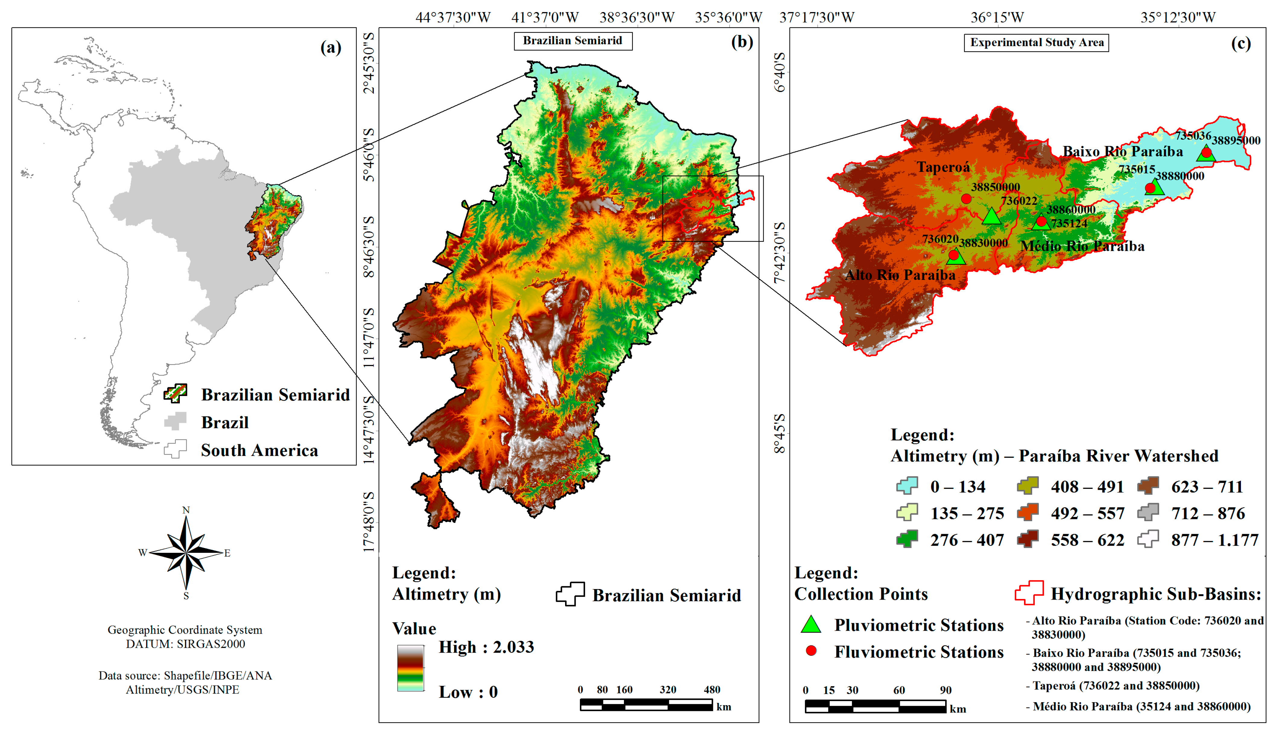
2.1. Study Area

The study was conducted in the Paraiba watershed, located between latitudes 8°0′00″ and 8°45′00″ S and longitudes 37°45′00″ and 38°45′00″ W. This basin covers an area of 20,123.4 km2, ranging from the Sertão region to the Zona da Mata, and discharging into the sea in the state of Paraíba. For the research, five pluviometric and fluviometric stations with temporal series of more than 30 years were selected (Figure 1).

2.2. Open Access Fluviometric and Pluviometric Data

The fluviometric and pluviometric data were collected through the Hidroweb website, a tool that is part of the National Information System on Water Resources, managed by the National Water Agency. This application allows access to various telemetric data collected by the National Hydrometeorological Network, such as information on rainfall and river flows, using the codes of the observed monitoring stations [19]. To assist in the download and processing of the data, the hydrobr package was used [20].

2.3. Satellite-Derived Data Available (MapBiomas Brazil)

The land use data used in the MapBiomas Brazil project were obtained from the Landsat satellite series and processed in Google Earth Engine (GEE) environment and were used to create thematic maps of land use and land cover. This spatio-temporal monitoring of the natural environment of Brazilian biomes was driven by the implementation of a low-cost and open-access methodology.
MapBiomas provides monitoring of native vegetation areas, including mapping of loss and/or resilience of natural vegetation cover in biomes. Additionally, it also covers monitoring of pasture areas, assessing the quality and degradation of these areas, as well as monitoring the evolution of irrigation and mapping of different agricultural crops. Other monitored aspects include water resources, such as the water supply condition of rivers, streams, lakes, lagoons, and strategic reservoirs, as well as urban infrastructure [9] and application for detecting dry and rainy seasons and identifying vulnerable areas [21].

2.4. Mann-Kendall Test

The trend analysis was performed for the annual precipitation series, total annual runoff, and land use (forested areas, farming (agriculture and pasture), and water) using the non-parametric statistical test of Mann-Kendall [22,23]. The test statistic (S) is described by Equation (1):
S = k = 1 n 1 j = k + 1 n sgn x j x i ,
where, “n” is the number of data points, “xj” and “xi” represent each of the measurements at different time steps i and j, with i ≠ j; and “sgn(xj − xi)” is defined by Equation (2):
Sgn = 1 ,   if   x j x i   >   0 0 ,   if   x j x i = 0 1 ,   if   x j x i   <   0 ,
If the dataset is uniformly and independently distributed, then the mean of S is zero, and the variance of S is determined by Equation (3):
Var S = n n 1   2 n + 5 t = 1 q t t 1 2 t + 5 /   18 ,
where, n—is the dataset number; t—is the number of data points with repeated values in a given group; q—is the number of groups containing repeated values.
In a long temporal series, the statistical value “S” can be represented by “Z” according to the following conditions of the Equation (4):
Z   ( S 1 Var ( S ) ,   S   >   0 ;   0 ,   S = 0 ;   S + 1 Var ( S ) ,   S   <   0 ) ,
When −1.96 ≤ Z ≤ 1.96, the null hypothesis (H0) is accepted, indicating that there is no statistically significant trend in the temporal series. The trend is considered significant at a 90% confidence level when |Z| > 1.64, at a 95% confidence level when |Z| > 1.96, and at a 99% confidence level when |Z| > 2.58. A positive value of Z indicates an increasing trend in the sequence, while a negative value of Z reflects a decreasing trend.

2.5. Statistical and Multivariate Data Analysis

An additional statistical procedure employed was Principal Component Analysis (PCA), used to assess the relationship between soil and rainfall, runoff and land use in the watershed aspect [24,25,26]. PCA employs an orthogonal transformation to convert a set of potentially correlated observations into a set of linearly uncorrelated variables. This transformation is defined in such a way that the first principal component has the highest possible variance, and each subsequent component, in order, has the highest possible variance while being orthogonal to the previous components [27]. The covariance matrix is assessed, allowing for the calculation of eigenvectors and eigenvalues associated with the matrix. Eigenvalues are computed to determine the contribution of each variable to the total variance of the principal components. A high contribution value indicates that the variable is well-represented in the principal component [15]. PCA generates two factors, with the first one representing the primary component (Dimension 1 or Dim1). The second factor is orthogonal to the first and is denoted as dimension 2 (Dim2). Each dimension or component is the result of the individual contributions of each of the original variables [28].
All analyses were conducted using RStudio, version R 3.3.0+ [29].

3. Results

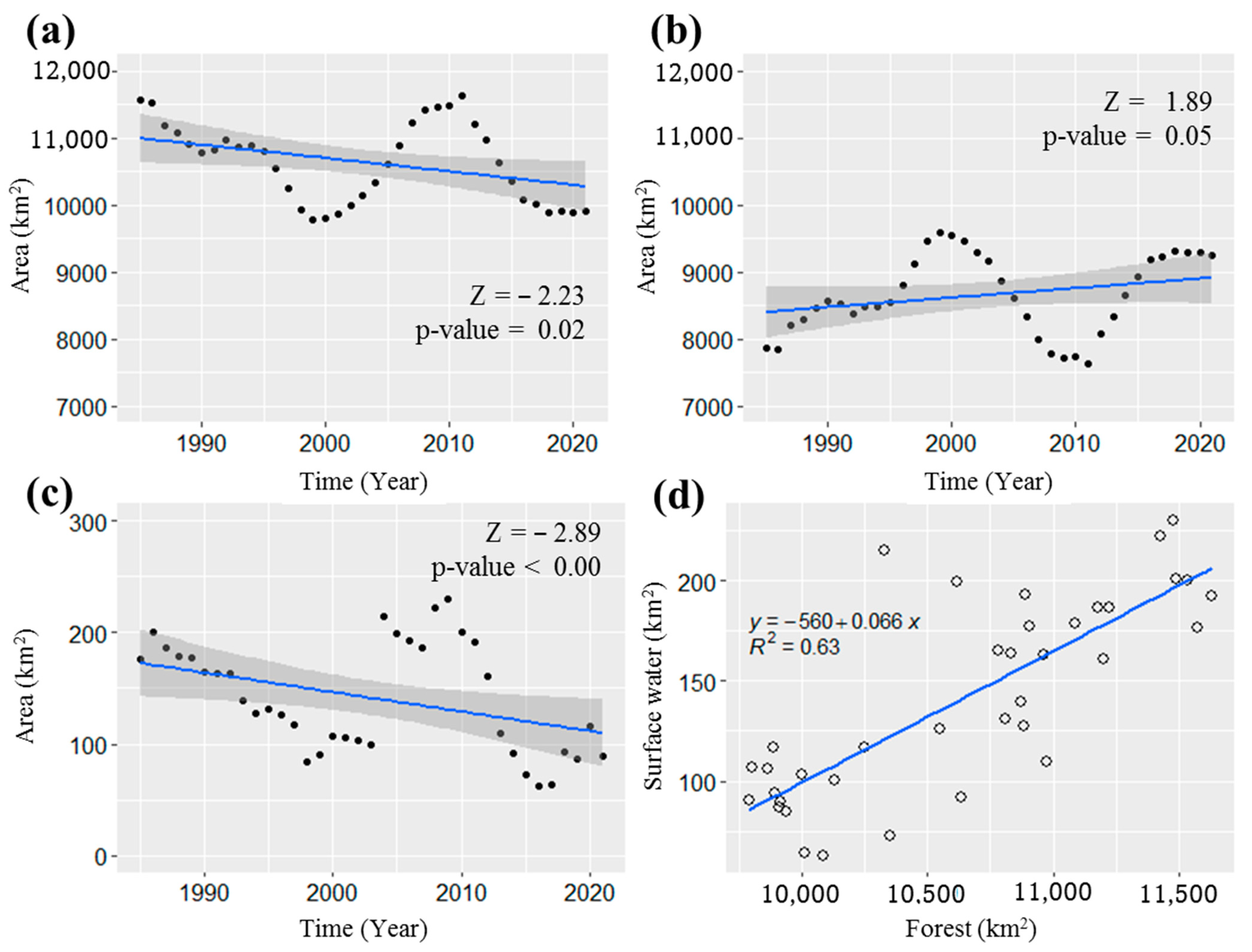
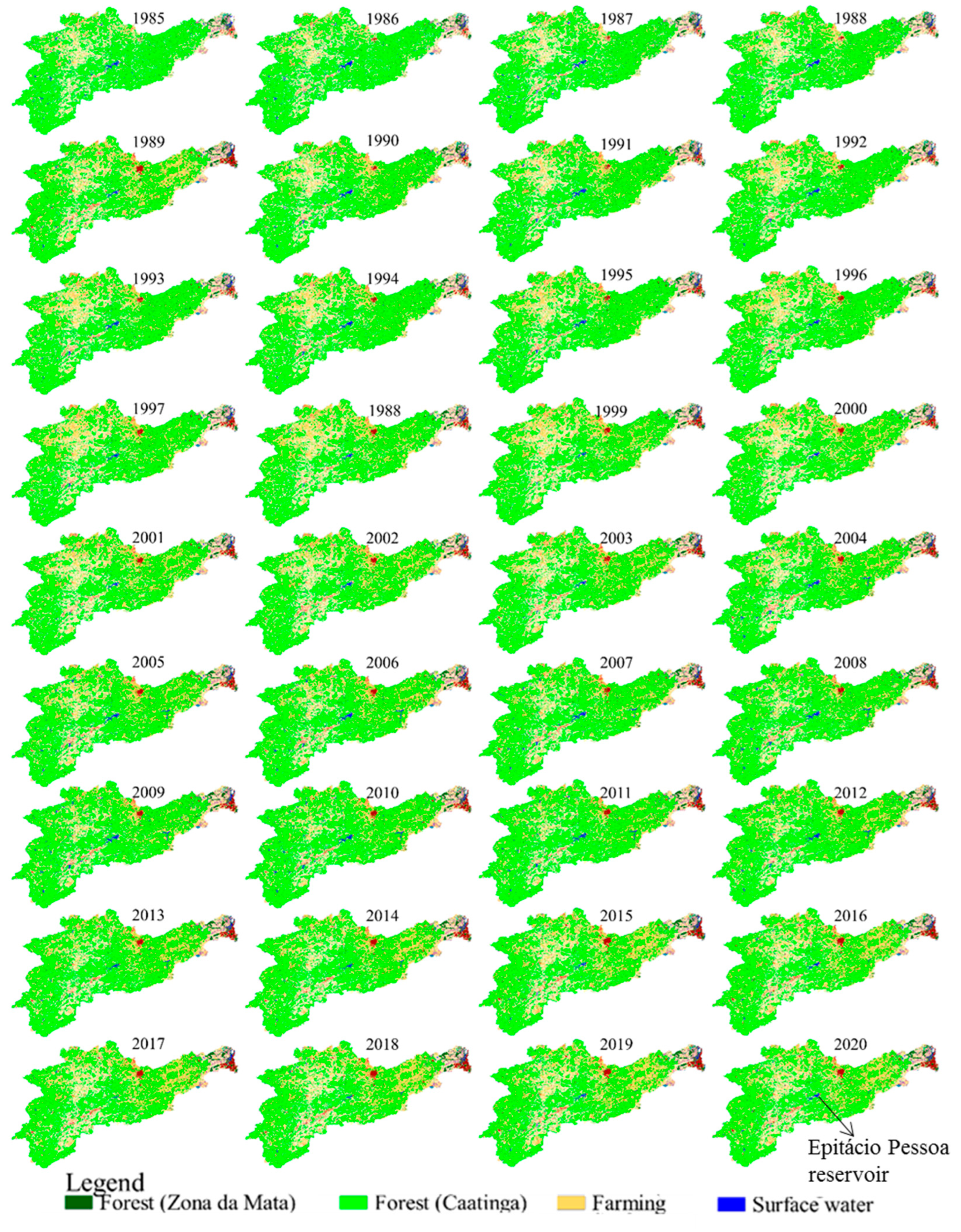
3.1. Temporal Analysis of Land Use in the Paraíba Watershed

The analysis results indicate statistically significant trends (95% confidence level) in the annual reduction of native forest area (Z = −2.23) (Figure 2a) and water bodies (Z = −2.89) (Figure 2c) in the Paraíba watershed. On the other hand, the agricultural area showed a significant increase at a 90% confidence level (Z = 1.89) (Figure 2b), indicating an expansion of agricultural activity that may be impacting the hydrodynamic dynamics of the region. The correlation analysis between water bodies and forests reveals a determination coefficient of 0.63 (Figure 2d), justifying that the decrease in forest area is also associated with a reduction in water availability.
By adopting a moving average of the first 5 years of the series (1985–1989) for land use data and comparing it with the total area of the Paraíba watershed (20,123.4 km2), in addition to comparing it with the last 5 years of the series (2017–2021), it was observed that there was a 12% reduction in forest area compared to the initial average area of the first 5 years (11,428.2 km2). Simultaneously, there was a 14% increase in agricultural area (8133.1 km2), while the area of water bodies showed a 51% reduction (184.1 km2) (Figure 2). These findings indicate that the Paraíba watershed has undergone significant changes in terms of vegetation cover and land use over the 36 years.
The reduction in the water bodies area may reflect environmental degradation in the basin, as clearly observed in the spatio-temporal land use maps (Figure 3).

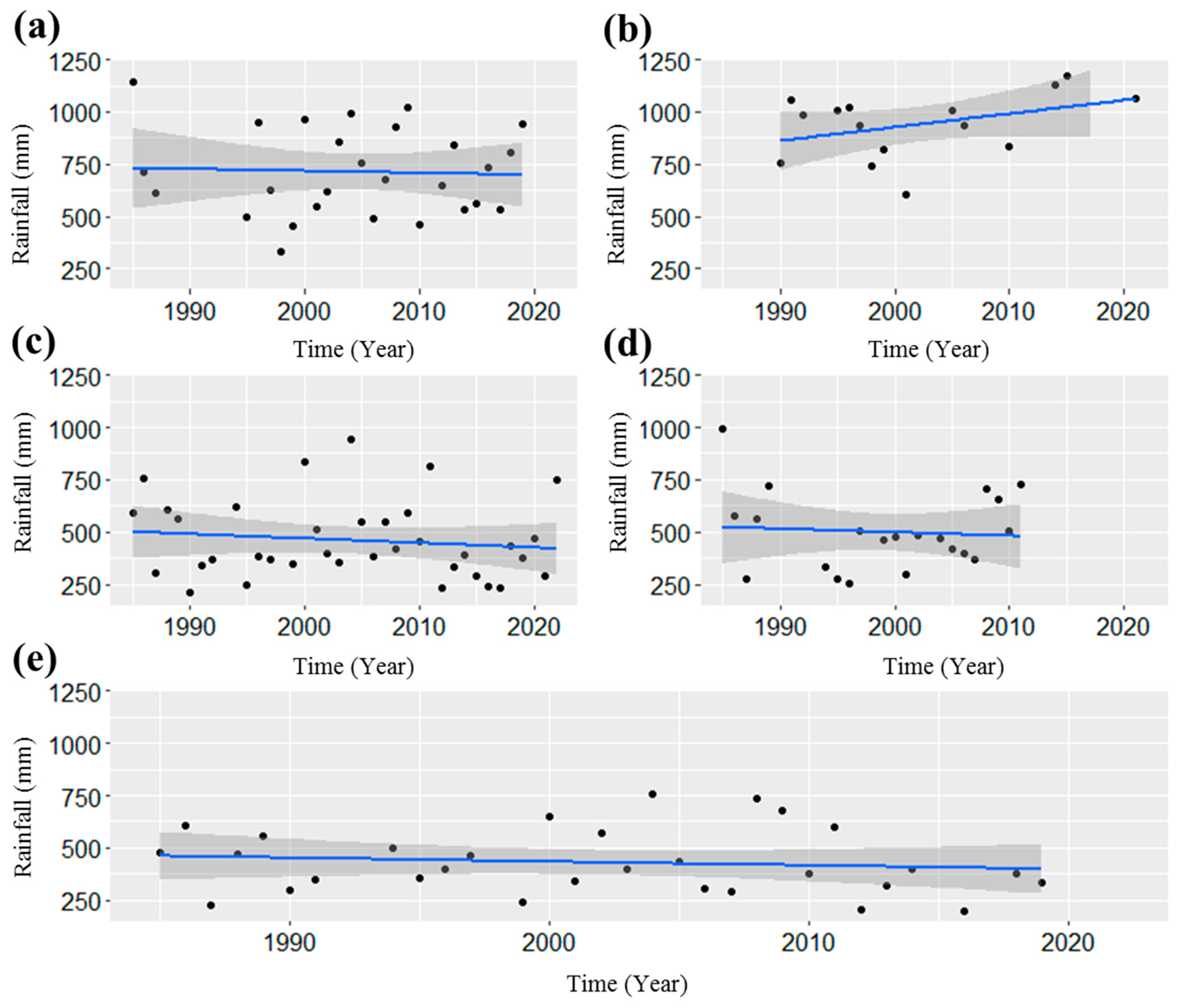
3.2. Temporal Analysis of Rainfall

It was observed that extensive vegetation suppression has occurred to the northwest, southwest, and east of the Epitácio Pessoa Reservoir. Despite the significant reduction (51%) (Figure 2) in water bodies observed in recent years, among the evaluated points, only point 736022 showed an increasing trend in rainfall (Z = 1.73) at a 90% significance level. In the remaining points, no significant change was identified in the studied hydrological series (Figure 4).

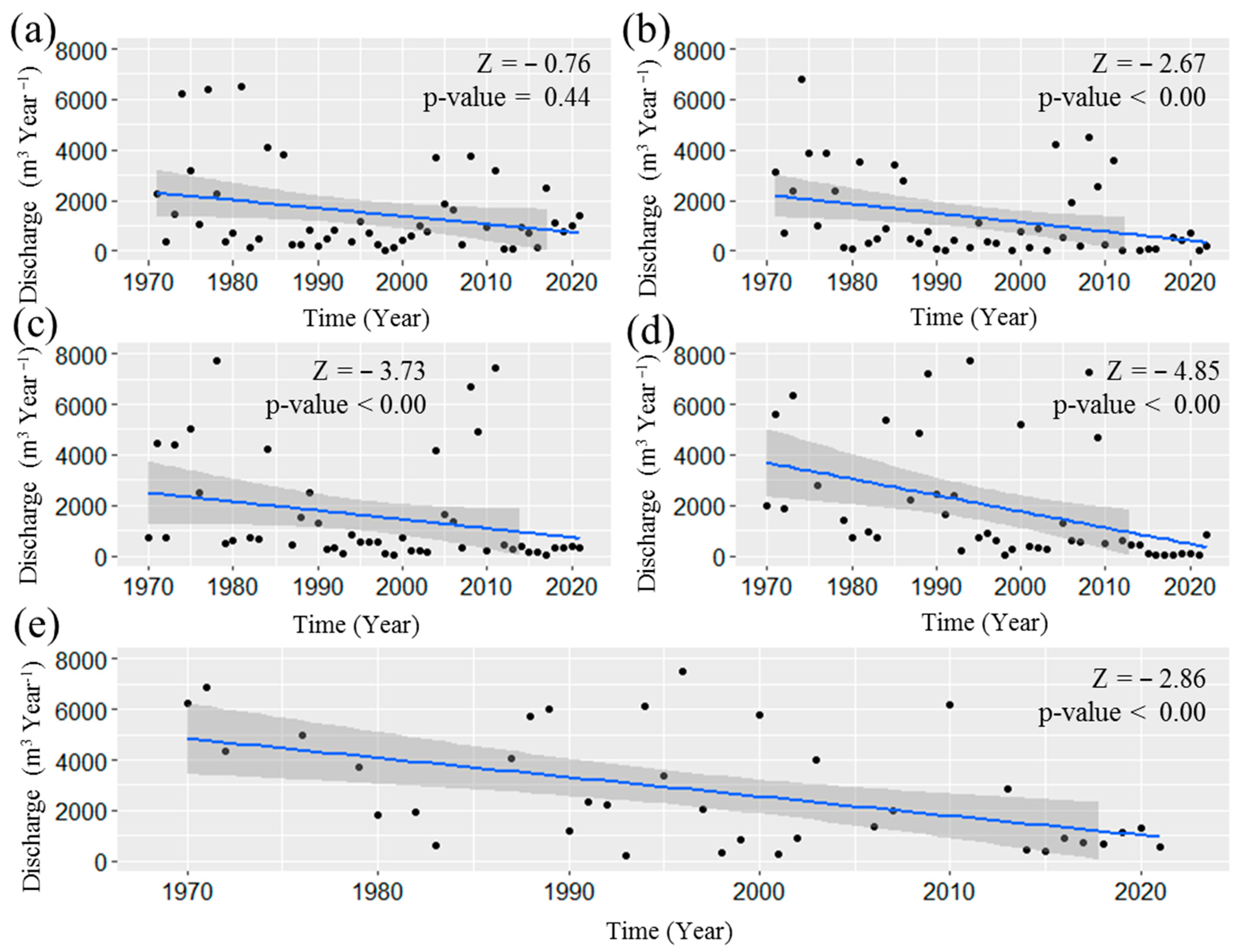
3.3. Temporal Analysis of Runoff Stations in the Paraíba Watershed

Only 38830000 station did not show a decreasing trend in runoff according to the Mann-Kendall test. The other stations (38850000, 38860000, 38880000, and 38895000) exhibited trends at a 99% confidence level, with values of (−2.67, −3.73, −4.85, −2.86 m3 per year), respectively (Figure 5).
Upon examining the magnitude of the trend, it was observed that there was a reduction of 54%, 61%, 64%, and 59% in the annual flow at the runoff stations 38850000, 38860000, 38880000, and 38895000, respectively.

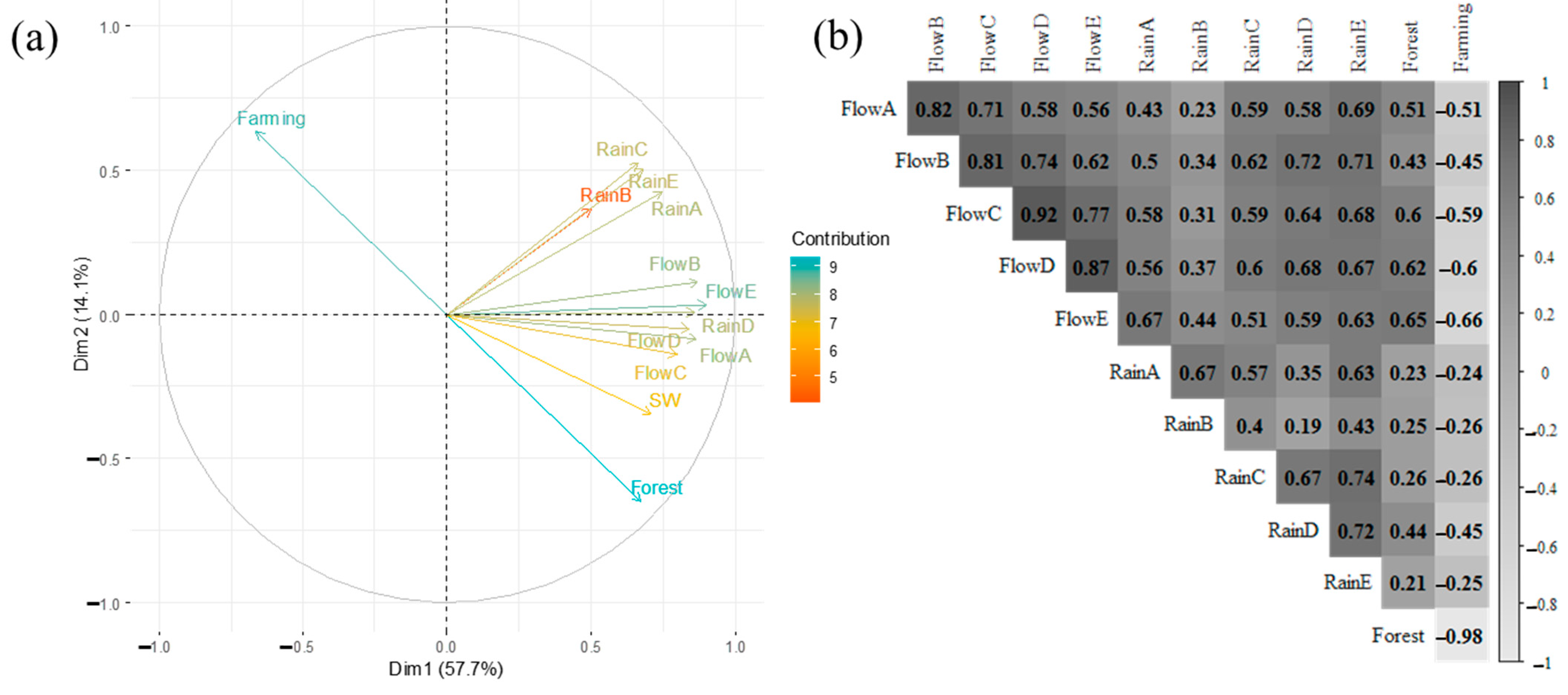
3.4. Multivariate Analysis of Rainfall, Runoff and Land Use

The principal components, Dim1 and Dim2, were responsible for explaining 71.8% of the total variability, with a special emphasis on Dim1, which contributed 57.7% of the total data variability. In this component, we notice that variables related to runoff are positioned on the positive side of variables such as precipitation, surface water, and forest cover. On the other hand, farming is opposed to forest cover (Figure 6a) and negative correlation of farming with forest cover, rainfall, and runoff (Figure 6b). This suggests that the reduction in forest area is associated with the expansion of farming, especially in the southwestern and eastern regions of the basin (Figure 3), implying a trend of reduced runoff in four out of the five monitoring points evaluated in the Paraíba watershed (Figure 5).
Forest had a significant positive impact on runoff (9%), demonstrating the importance of Caatinga vegetation in conserving water resources and influencing the hydrological dynamics of the watershed (Figure 6a).
The Spearman correlation reveals that farming exerts a negative influence on both rainfall and runoff, strengthening the considerations obtained in the PCA analysis, with emphasis on the significant negative correlation with forest cover, reaching a coefficient of −0.98 (Figure 6b).
The pluviometric station 735015 (RainD) and the fluviometric station 38880000 (FlowD) showed the most solid relationship, with smaller angles between the vectors. It is relevant to observe that in this region, changes in land cover over time were less variable. On the other hand, the vectors of the pluviometric station 736020 (RainA) and the fluviometric station 38830000 (FlowA) showed a greater separation (larger angles) between them, which is associated with the area that suffered the greatest negative impact in reducing Caatinga vegetation.

4. Discussion

4.1. Temporal Analysis of Land Use

The annual reduction in native forest, water bodies and a significant increase in agricultural area in the Paraíba river basin (Figure 2) are results that are crucial for understanding environmental changes in the region and can provide support for the implementation of conservation and sustainable natural resource management measures.
The reduction in forest area and the increase in agricultural area may be related to agricultural expansion in the region.
In the Semiarid region of Africa, vegetation degradation has been found to be correlated with increased drought conditions in the region. Therefore, it is recommended that measures be immediately implemented to mitigate the adverse impact of climate variability and worsening aridity on vegetation and ecosystem services [13]. This study corroborates our own research findings as well as those presented by [30], who sought to discern the historical patterns of drought in the Greater Horn of Africa and recorded a pervasive tendency towards escalating drought.
The spatio-temporal maps of land use show a reduction in water bodies (Figure 3). This pattern of substantial land use change has been highlighted by [9] for Campina Grande, PB municipality. Over time, there has been a reduction in forested areas, as indicated by the spectral condition of Caatinga vegetation cover. The significant reduction of natural vegetation in the semiarid region is evidenced by the expansion of agricultural areas (cropland and pasture) and urban infrastructure over the last three decades.
According to [31], the low percentage of Caatinga vegetation cover and the predominance of farming are correlated with animal density by municipalities, indicating the strong influence of this activity on vegetation cover reduction. [18] identified a similar pattern of land use change and expansion of farming areas, listing the main consequences of these land cover alterations as erosion and soil degradation, rural-urban migration, fragmentation of farming lands, climate change, and reduced crop yields.
Due to the considerable portion of the territory of the Paraíba River Basin located in a semi-arid environment, irrigation appears as an extremely important technology to increase the production and diversification of agricultural crops. The agricultural areas identified and mapped correspond to 21.42% of productive establishments [32].
The main agricultural crops grown in the region include tomatoes, peppers, beans, cabbage, lettuce and onions, both during and between harvests, as well as bananas and coconuts, using drip, furrow and micro-sprinkler irrigation systems. It is important to highlight the significant presence of these activities in the vicinity of the Epitácio Pessoa Dam [33].
According to MapBiomas [12], through land cover and land use monitoring, the data indicates that the São Francisco watershed experienced a significant loss of its natural water surface between 1985 and 2020. According to the results, the loss was 50%, but it’s important to note that human actions, such as artificially increasing water surface in reservoirs, contributed to a 13% increase in water surface. This means that the actual reduction was 4%, with the largest losses occurring in the Upper and Lower São Francisco regions, with reductions of 19% and 21%, respectively.

4.2. Temporal Analysis of Rainfall

In the Brazilian Northeast, trends of both reduced and increased rainfall, as well as a decrease in rainy days, have been observed [3]. In our study (Figure 4), although no significant reduction was observed at the evaluated points, a negative slope of the trend line was observed at 4 stations (736020, 735124, 735015, and 735036). It is crucial to continue monitoring in this regard, not only concerning rainfall but also regarding reservoirs.
Regarding the Epitácio Pessoa Reservoir, one of the most important reservoirs in the Paraíba watershed, an evaluation of the relationship between rainfall from 1972 to 2016 in the reservoir’s contributing basin and its volume revealed that historically, its recharge is concentrated more in the first months of the year during the rainy season. Its volume exhibits high variability and is conditioned by multiple water uses from the reservoir, particularly in cities that demand substantial volumes [34].
In order to prevent the collapse of Epitácio Pessoa Reservoir due to the arrival of dead-level volume, as a result of drought and the high multiple use of the reservoir’s water, which is responsible for supplying the important city of Campina Grande and the neighboring cities, the contribution of waters from the São Francisco River Integration Project with the Northern Northeast Basins (PISF) has improved the quantitative and qualitative water security in relation to physical and chemical parameters, particularly in relation to ammonia, EC, chlorides, hardness, sulfate and STD [16,34,35].
Correia et al. [36] identified eleven municipalities within the contributing basin of the Epitácio Pessoa Reservoir where land use is predominantly oriented towards agricultural and livestock activities, resulting in low coverage of native vegetation. Due to these agricultural and livestock practices, soil leaching, and erosion occur, directly impacting the river channel, leading to siltation and eutrophication of the water body. Additionally, the development of cyanobacteria is also observed because of these activities, contributing to the degradation of the aquatic ecosystem. These environmental issues underscore the need for the implementation of sustainable management practices and conservation measures to protect the natural resources of the region.

4.3. Temporal Analysis of Runoff Stations

The high reductions in annual runoff (Figure 5) indicate that the Paraíba watershed has undergone significant changes in terms of vegetation cover, land use, and rainfall variability. This scenario may have negative implications for water availability in the region, especially during extended drought periods. Similarly, Fernandes et al. [37] found that changes to land use coverage within the Sao Francisco River Basin had stark financial implications. This research revealed a loss of around US$3.2 billion from reduced carbon sequestration and stocks, as well as disruptions to water usage dynamics.
The modeling of future scenarios in the context of watersheds raises concerns about the intense land use over time, and such climate changes have a direct impact on the water resources scarcity [38].
The collected and analyzed information is of fundamental importance for hydrological modeling. In this sense, several models have the potential to provide solid answers and contribute to decision-making related to water resource management, considering changes in land use and incorporating climate trends [39]. It is worth noting that precipitation, as the main source of water supply for the watershed and responsible for the balance of the water budget, must be thoroughly evaluated in future simulations to support decision-making [40].

4.4. Multivariate Analysis of Rainfall, Runoff and Land Use

The Caatinga forest has a significant impact on runoff regulation (Figure 6), in accordance with the study of [2], which indicated that deforested areas led to a reduction of approximately 22 mm of rainfall per year compared to areas covered by native Caatinga vegetation, representing a decrease of about 5%.
Principal Component Analysis (PCA) showed potential for hydrological assessment, exploring the associations between precipitation and runoff, in the Darong River watershed, situated in Guangxi province, China [26]. Additionally, it was utilized to analyze the relationships among precipitation events, surface runoff, and soil erosion on the Pisha sandstone slopes of the Loess Plateau in China, where it has been demonstrated that forests play a pivotal role in erosion control [25]. Therefore, PCA offers revelant insights for the modelling and management of stormwater within watersheds [24].
In the São Francisco watershed, the runoff water monitoring in the Verde Grande Sub-Basin over time shows a reduction in runoff of 80.5% from 1950 to 1976 and 69.2% from 1979 to 2000 [41]. An analysis of potential droughts in prospective scenarios up to 2030 has also suggested that the reservoir volume would decrease, potentially reaching critical levels by that point in time [42].
The significant trend of decreasing vegetation cover and runoff rates at various monitoring points in the Paraíba River Watershed, along with the negative correlation between runoff and the increase in degraded areas, demands proactive attention from administrative and governmental institutions in the state. It is imperative to intensify initiatives for the restoration of degraded areas, with particular emphasis on preserving riparian forests. As highlighted by [43], riparian forests play a fundamental role as a natural barrier for water runoff, attenuating its direct impact on the soil and preventing erosion and the deposition of solid particles in riverbeds, thus avoiding sedimentation. They play a crucial role in maintaining environmental balance.
The significant changes in the landscape, especially due to deforestation, have consequences for hydrological behavior, triggering erosional processes, sedimentation of water bodies, and a reduction in their runoff rates, among other associated phenomena. These changes have a negative impact on the local ecosystem, adversely affecting the quality and availability of water resources and compromising environmental sustainability [17].

5. Conclusions

From 1985 to 2020, the Paraíba watershed underwent significant changes in land use, with a notable reduction in native vegetation cover and a decrease in water bodies. These alterations have resulted in substantial reductions in annual runoff along the main surface flow channel. This scenario serves as a warning about the importance of expanding water resource management in the region to preserve and sustainably utilize the available natural resources.
The spatio-temporal monitoring of land use has enabled the identification of the most vulnerable areas in the Paraíba watershed. Therefore, there is an urgent need to adopt appropriate conservation, monitoring, and management measures to address the challenges posed by changes in land and climate use, to ensure the sustainable availability of water and soil.

Author Contributions

Conceptualization, A.A.d.C., M.J.G.d.S., F.R.d.C.B. and J.S.A.; methodology, A.A.d.C., T.A.B.A., J.D., J.L.B.d.S., M.V.d.S. and I.T.R.C.; software, A.A.d.C.; validation, A.A.d.C.; investigation, A.A.d.C., A.A.d.A.M., M.J.G.d.S., F.R.d.C.B. and J.S.A.; data curation, A.A.d.C., T.A.B.A. and T.G.F.d.S.; writing—original draft preparation, A.A.d.C., I.T.R.C. and J.L.B.d.S.; writing—review and editing, A.A.d.C., J.D., J.L.B.d.S., M.V.d.S., I.T.R.C., A.A.d.A.M. and T.G.F.d.S.; visualization, A.A.d.C., J.L.B.d.S., M.V.d.S., T.A.B.A., J.D., A.A.d.A.M., T.G.F.d.S., M.J.G.d.S., F.R.d.C.B. and J.S.A.; supervision, M.J.G.d.S., F.R.d.C.B. and J.S.A.; project administration, F.R.d.C.B. and J.S.A.; funding acquisition, F.R.d.C.B. and J.S.A. All authors have read and agreed to the published version of the manuscript.

Funding

This research received no external funding.

Data Availability Statement

Publicly available datasets were analyzed in this study. This data can be found here: https://www.snirh.gov.br/hidroweb-mobile/mapa/filtro para a Bacia Hidrográfico do Rio Paraíba-PB.

Acknowledgments

To the National Council for Scientific and Technological Development (CNPq), the Ministry of Science and Technology (MCTI), and the National Institute of Semiarid (INSA), for their institutional and financial support to the scholarship holders, to the National Water Resources Information System (SNIRH), and to the HidroWeb portal managed by the National Water Agency (ANA) for providing the data.

Conflicts of Interest

The authors declare no conflict of interest.

References

  1. Shukla, P.R.; Skea, J.; Slade, R.; Al Khourdajie, A.; van Diemen, R.; McCollum, D.; Pathak, M.; Some, S.; Vyas, P.; Fradera, R.; et al. Climate Change 2022: Mitigation of Climate Change; Contribution of Working Group III to the Sixth Assessment Report of the Intergovernmental Panel on Climate Change; Cambridge University Press: Cambridge, UK; New York, NY, USA, 2022. [Google Scholar] [CrossRef]
  2. de Queiroz, M.G.; da Silva, T.G.F.; Zolnier, S.; de Souza, C.A.A.; de Souza, L.S.B.; do Nascimento Araújo, G.; da Rosa Ferraz Jardim, A.M.; de Moura, M.S.B. Partitioning of Rainfall in a Seasonal Dry Tropical Forest. Ecohydrol. Hydrobiol. 2020, 20, 230–242. [Google Scholar] [CrossRef]
  3. de Medeiros, F.J.; de Oliveira, C.P. Assessment of Dry and Heavy Rainfall Days and Their Projected Changes over Northeast Brazil in Coupled Model Intercomparison Project Phase 6 Models. Int. J. Climatol. 2022, 42, 8665–8686. [Google Scholar] [CrossRef]
  4. Avalon Cullen, C.; Al Suhili, R. Assessing Rainfall Variability in Jamaica Using CHIRPS: Techniques and Measures for Persistence, Long and Short-Term Trends. Geographies 2023, 3, 375–397. [Google Scholar] [CrossRef]
  5. Patakamuri, S.K.; Muthiah, K.; Sridhar, V. Long-Term Homogeneity, Trend, and Change-Point Analysis of Rainfall in the Arid District of Ananthapuramu, Andhra Pradesh State, India. Water 2020, 12, 211. [Google Scholar] [CrossRef]
  6. Khan, N.; Pour, S.H.; Shahid, S.; Ismail, T.; Ahmed, K.; Chung, E.; Nawaz, N.; Wang, X. Spatial Distribution of Secular Trends in Rainfall Indices of Peninsular Malaysia in the Presence of Long-term Persistence. Meteorol. Appl. 2019, 26, 655–670. [Google Scholar] [CrossRef]
  7. Pan, X.; Li, T.; Sun, Y.; Zhu, Z. Cause of Extreme Heavy and Persistent Rainfall over Yangtze River in Summer 2020. Adv. Atmos. Sci. 2021, 38, 1994–2009. [Google Scholar] [CrossRef]
  8. Ogunrinde, A.T.; Oguntunde, P.G.; Akinwumiju, A.S.; Fasinmirin, J.T. Analysis of Recent Changes in Rainfall and Drought Indices in Nigeria, 1981–2015. Hydrol. Sci. J. 2019, 64, 1755–1768. [Google Scholar] [CrossRef]
  9. da Silva, J.L.B.; de Albuquerque Moura, G.B.; da Silva, M.V.; de Oliveira-Júnior, J.F.; da Rosa Ferraz Jardim, A.M.; Refati, D.C.; da Cunha Correia Lima, R.; de Carvalho, A.A.; Ferreira, M.B.; de Brito, J.I.B.; et al. Environmental Degradation of Vegetation Cover and Water Bodies in the Semiarid Region of the Brazilian Northeast via Cloud Geoprocessing Techniques Applied to Orbital Data. J. S. Am. Earth Sci. 2023, 121, 104164. [Google Scholar] [CrossRef]
  10. de Oliveira Júnior, J.G.; Lopes, P.M.O.; Nascimento, C.R.; de Albuquerque Moura, G.B.; de Oliveira Júnior, J.F. Space-Temporal Detection of Environmental Changes in the Brazilian Semiarid through Google Earth Engine and GIS. J. S. Am. Earth Sci. 2023, 127, 104403. [Google Scholar] [CrossRef]
  11. Souza, C.M., Jr.; Shimbo, J.Z.; Rosa, M.R.; Parente, L.L.; Alencar, A.A.; Rudorff, B.F.T.; Hasenack, H.; Matsumoto, M.; Ferreira, L.G.; Souza-Filho, P.W.M.; et al. Reconstructing Three Decades of Land Use and Land Cover Changes in Brazilian Biomes with Landsat Archive and Earth Engine. Remote Sens. 2020, 12, 2735. [Google Scholar] [CrossRef]
  12. MapBiomas Coleção 7.1 Da Série Anual de Mapas de Cobertura e Uso Da Terra Do Brasil. Available online: https://mapbiomas.org/colecoes-mapbiomas-1?cama_set_language=pt-BR (accessed on 1 July 2023).
  13. Measho, S.; Chen, B.; Trisurat, Y.; Pellikka, P.; Guo, L.; Arunyawat, S.; Tuankrua, V.; Ogbazghi, W.; Yemane, T. Spatio-Temporal Analysis of Vegetation Dynamics as a Response to Climate Variability and Drought Patterns in the Semiarid Region, Eritrea. Remote Sens. 2019, 11, 724. [Google Scholar] [CrossRef]
  14. de Sousa, J.Y.B.; Velozo, A.L.S.; Pereira, J.R.; Santos, G.F.; Araújo, S.R.D.; de Araújo, S.N.R. Detecção Temporal de Impactos em Áreas Conflitantes e Uso Dos Recursos Hídricos No Semiárido Da Paraíba. Rev. Geociências Nordeste 2020, 6, 24–31. [Google Scholar] [CrossRef]
  15. da Rosa Ferraz Jardim, A.M.; da Silva, M.V.; Silva, A.R.; dos Santos, A.; Pandorfi, H.; de Oliveira-Júnior, J.F.; de Lima, J.L.M.P.; de Souza, L.S.B.; do Nascimento Araújo Júnior, G.; Lopes, P.M.O.; et al. Spatiotemporal Climatic Analysis in Pernambuco State, Northeast Brazil. J. Atmos. Sol. Terr. Phys. 2021, 223, 105733. [Google Scholar] [CrossRef]
  16. da Silva Morais, A.C.; Barbosa, N.F.M. Modelagem de Dados Volumétricos do Açude Epitácio Pessoa (Boqueirão). Res. Soc. Dev. 2022, 11, e409111133772. [Google Scholar] [CrossRef]
  17. de Oliveira, L.N.; de Aquino, C.M.S. Dinâmica Temporal Do Uso e Cobertura Da Terra Na Fronteira Agrícola Do Matopiba: Análise Na Sub-Bacia Hidrográfica Do Rio Gurguéia-Piauí. REVISTA EQUADOR 2020, 9, 317–333. [Google Scholar] [CrossRef]
  18. Ayele, H.A.; Aga, A.O.; Belayneh, L.; Wanjala, T.W. Hydrological Responses to Land Use/Land Cover Changes in Koga Watershed, Upper Blue Nile, Ethiopia. Geographies 2023, 3, 60–81. [Google Scholar] [CrossRef]
  19. Agência Nacional de Águas. HidroWeb: Sistemas de Informações Hidrológicas. 2023. Available online: https://www.snirh.gov.br/hidroweb-mobile/mapa (accessed on 1 July 2023).
  20. Calegario, A.; Althoff, D. Access to the Brazilian National Water Agency (Agência Nacional de Águas) Hydrological Data 2023. Available online: https://dadosabertos.ana.gov.br/ (accessed on 1 July 2023).
  21. Hasan, I.; Liu, W.; Xu, C. Monitoring and Analyzing the Seasonal Wetland Inundation Dynamics in the Everglades from 2002 to 2021 Using Google Earth Engine. Geographies 2023, 3, 161–177. [Google Scholar] [CrossRef]
  22. Mann, H.B. Nonparametric Tests Against Trend. Econometrica 1945, 13, 245. [Google Scholar] [CrossRef]
  23. Kendall, M.G. Rank Correlation Methods. London, 2nd ed.; Griffin: London, UK, 1975. [Google Scholar]
  24. das Graças Silva, T.F.; Beltrán, D.; de Oliveira Nascimento, N.; Rodríguez, J.P.; Mancipe-Muñoz, N. Assessing Major Drivers of Runoff Water Quality Using Principal Component Analysis: A Case Study from a Colombian and a Brazilian Catchments. Urban Water J. 2022, 2022, 1–13. [Google Scholar] [CrossRef]
  25. Yu, Y.; Zhu, R.; Ma, D.; Liu, D.; Liu, Y.; Gao, Z.; Yin, M.; Bandala, E.R.; Rodrigo-Comino, J. Multiple Surface Runoff and Soil Loss Responses by Sandstone Morphologies to Land-Use and Precipitation Regimes Changes in the Loess Plateau, China. Catena 2022, 217, 106477. [Google Scholar] [CrossRef]
  26. Hu, T.; Wu, F.; Zhang, X. Rainfall–Runoff Modeling Using Principal Component Analysis and Neural Network. Hydrol. Res. 2007, 38, 235–248. [Google Scholar] [CrossRef]
  27. Wold, S.; Esbensen, K.; Geladi, P. Principal Component Analysis. Chemom. Intell. Lab. Syst. 1987, 2, 37–52. [Google Scholar] [CrossRef]
  28. dos Santos Souza Marinho, R.; Duro, R.L.S.; de Oliveira Mota, M.T.; Hunter, J.; Diaz, R.S.; Kawakubo, F.S.; Komninakis, S.V. Environmental Changes and the Impact on the Human Infections by Dengue, Chikungunya and Zika Viruses in Northern Brazil, 2010–2019. Int. J. Environ. Res. Public Health 2022, 19, 12665. [Google Scholar] [CrossRef] [PubMed]
  29. R Core Team: R: A Language and Environment for Statistical Computing; R Foundation for Statistical Computing: Vienna, Austria, 2023; Available online: https://www.R-project.org/ (accessed on 1 July 2023).
  30. Gebremeskel Haile, G.; Tang, Q.; Leng, G.; Jia, G.; Wang, J.; Cai, D.; Sun, S.; Baniya, B.; Zhang, Q. Long-Term Spatiotemporal Variation of Drought Patterns over the Greater Horn of Africa. Sci. Total Environ. 2020, 704, 135299. [Google Scholar] [CrossRef]
  31. Da Silva Seabra, V.; Xavier, R.A.; Damasceno, J.; Da Conceição Dornellas, P. Mapeamento Do Uso e Cobertura Do Solo Da Bacia Do Rio Taperoá: Região Semiárida Do Estado Da Paraíba. Caminhos Geogr. 2014, 15, 127–137. [Google Scholar] [CrossRef]
  32. Francisco, P.R.M.; Silva, V.F.; Ribeiro, G.D.N.; Santos, D.; Ayres, G.D.J. Potencial de Expansão Da Irrigação Em Bacia Hidrográfica Da Região Do Médio Curso Do Rio Paraíba. POLÊM!CA 2023, 21, 146–165. [Google Scholar] [CrossRef]
  33. de Oliveira Simões, J.P.; dos Santos, S.L. Análise Dos Indicadores de Desempenho de Áreas Irrigadas No Município de Boqueirão, Estado Da Paraíba. Rev. Verde Agroecol. Desenvolv. Sustentável 2014, 9, 356–361. [Google Scholar]
  34. de Andrade, A.R.; de Lima, P.R.C.; de Oliveira, J.V.P.; Lucena, D.B. Análise Da Relação Entre Precipitação e Volume Nas Sub-Bacias Contribuintes Para o Açude Epitácio Pessoa. Rev. Bras. Climatol. 2019, 25, 719–736. [Google Scholar] [CrossRef]
  35. Farto, C.D.; da Silva, T.C. Variações Da Qualidade Da Água de Chuva e de Açudes Armazenada Em Cisternas Em Municípios Do Semiárido Do Estado Da Paraíba. Eng. Sanit. Ambient. 2020, 25, 859–871. [Google Scholar] [CrossRef]
  36. Correia, I.; Correia, I.M.G.; da Silva, J.B. Águas Da Transposição Do Rio São Francisco Na Paraíba: Esgotos e Inviabilidades Municipais. AMBIÊNCIA 2021, 16, 799–816. [Google Scholar]
  37. Fernandes, M.M.; de Moura Fernandes, M.R.; Garcia, J.R.; Matricardi, E.A.T.; de Souza Lima, A.H.; de Araújo Filho, R.N.; Filho, R.R.G.; Piscoya, V.C.; Piscoya, T.O.F.; Filho, M.C. Land Use and Land Cover Changes and Carbon Stock Valuation in the São Francisco River Basin, Brazil. Environ. Chall. 2021, 5, 100247. [Google Scholar] [CrossRef]
  38. Rafiei-Sardooi, E.; Azareh, A.; Joorabian Shooshtari, S.; Parteli, E.J.R. Long-Term Assessment of Land-Use and Climate Change on Water Scarcity in an Arid Basin in Iran. Ecol. Model. 2022, 467, 109934. [Google Scholar] [CrossRef]
  39. Srinivas, R.; Das, B.; Singhal, A. Integrated Watershed Modeling Using Interval Valued Fuzzy Computations to Enhance Watershed Restoration and Protection at Field-Scale. Stoch. Environ. Res. Risk Assess. 2022, 36, 1429–1445. [Google Scholar] [CrossRef]
  40. Rufino, P.R.; Gücker, B.; Faramarzi, M.; Boëchat, I.G.; da Silva Cardozo, F.; Santos, P.R.; Zanin, G.D.; Mataveli, G.; Pereira, G. Evaluation of the SWAT Model for the Simulation of Flow and Water Balance Based on Orbital Data in a Poorly Monitored Basin in the Brazilian Amazon. Geographies 2022, 3, 1–18. [Google Scholar] [CrossRef]
  41. Pereira, S.B.; Pruski, F.F.; da Silva, D.D.; Ramos, M.M. Estudo Do Comportamento Hidrológico Do Rio São Francisco e Seus Principais Afluentes. Rev. Bras. Eng. Agrícola Ambient. 2007, 11, 615–622. [Google Scholar] [CrossRef]
  42. da Costa Silva, J.F.C.B.; da Silva, R.M.; Santos, C.A.G.; Silva, A.M.; Vianna, P.C.G. Analysis of the Response of the Epitácio Pessoa Reservoir (Brazilian Semiarid Region) to Potential Future Drought, Water Transfer and LULC Scenarios. Nat. Hazards 2021, 108, 1347–1371. [Google Scholar] [CrossRef]
  43. Correia, I.M.G.; de Souza, B.H.; Moura, D.C.; de Souza, Y.G. Mata Ciliar, Conservação e Sustentabilidade, Fundamentos Da Importância Para o Semiárido Paraibano: Estudo de Caso No Alto Curso Do Rio Paraíba. Rev. Geociências Nordeste 2019, 5, 41–60. [Google Scholar] [CrossRef]
Figure 1. Location map (a) with digital elevation model (DEM) (b), pluviometric data for stations in the ANA database, 736022, 735124, 735015, and 735036, and fluviometric data for stations 38830000, 38850000, 38860000, 38880000, and 38895000 in the Paraiba watershed (c).
Geographies 03 00038 g001
Figure 2. Mann-Kendall Trend for forest areas (a), agriculture (b), water bodies (c), and correlation between forest area and water body area (d) in the Paraíba watershed.
Geographies 03 00038 g002
Figure 3. Land use for forested areas, farming (agriculture and pasture), and water bodies in the Paraíba watershed.
Geographies 03 00038 g003
Figure 4. Mann-Kendall Trend for precipitation at the rainfall stations recorded in the ANA database, 736020 (a), 736022 (b), 735124 (c), 735015 (d), and 735036 (e) in the Paraíba Watershed.
Geographies 03 00038 g004
Figure 5. Mann-Kendall Trend for the runoff stations recorded in the ANA database, 38830000 (a), 38850000 (b), 38860000 (c), 38880000 (d), and 38895000 (e) in the Paraíba watershed.
Geographies 03 00038 g005
Figure 6. Principal Component Analysis (PCA) (a) and Spearman correlation (b) of land use data (forest, farming (agriculture and pasture), and surface water—SW), rainfall data for ANA 736020 base stations (RainA), 736022 (RainB), 735124 (RainC), 735015 (RainD), and 735036 (RainE), and runoff data for stations 38830000 (FlowA), 38850000 (FlowB), 38860000 (FlowC), 38880000 (FlowD), and 38895000 (FlowE) in the Paraiba watershed.
Geographies 03 00038 g006
Disclaimer/Publisher’s Note: The statements, opinions and data contained in all publications are solely those of the individual author(s) and contributor(s) and not of MDPI and/or the editor(s). MDPI and/or the editor(s) disclaim responsibility for any injury to people or property resulting from any ideas, methods, instructions or products referred to in the content.

