
Deep Learning in the Mapping of Agricultural Land Use Using Sentinel-2 Satellite Data


Abstract
1. Introduction
2. Study Area and Dataset
3. Methodology
3.1. Preprocessing of the Input Data
3.2. Deep Learning and Machine Learning
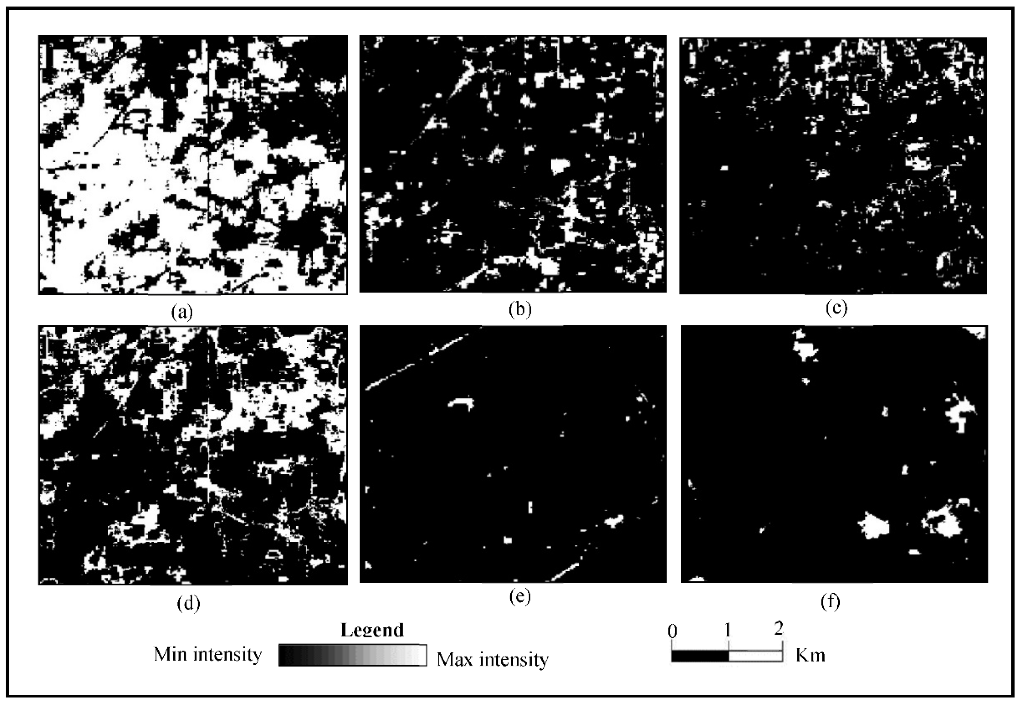
4. Results and Discussion
5. Conclusions
Author Contributions
Funding
Data Availability Statement
Acknowledgments
Conflicts of Interest
References
- Nasiri, V.; Deljouei, A.; Moradi, F.; Sadeghi, S.M.M.; Borz, S.A. Land Use and Land Cover Mapping Using Sentinel-2, Landsat-8 Two Composition Methods. Remote Sens. 2022, 14, 1977. [Google Scholar] [CrossRef]
- Sicre, C.M.; Fieuzal, R.; Baup, F. Contribution of multispectral (optical and radar) satellite images to the classi fi cation of agricultural surfaces. Int. J. Appl. Earth Obs. Geoinf. 2020, 84, 101972. [Google Scholar]
- Hudait, M.; Patel, P.P. Crop-type mapping and acreage estimation in smallholding plots using Sentinel-2 images and machine learning algorithms: Some comparisons. Egypt. J. Remote Sens. Space Sci. 2022, 25, 147–156. [Google Scholar] [CrossRef]
- Ahmadlou, M.; Al-Fugara, A.; Al-Shabeeb, A.R.; Arora, A.; Al-Adamat, R.; Pham, Q.B.; Al-Ansari, N.; Linh, N.T.T.; Sajedi, H. Flood susceptibility mapping and assessment using a novel deep learning model combining multilayer perceptron and autoencoder neural networks. J. Flood Risk Manag. 2021, 14, e12683. [Google Scholar] [CrossRef]
- do Nascimento Bendini, H.; Fonseca, L.M.G.; Schwieder, M.; Körting, T.S.; Rufin, P.; Sanches, I.D.A.; Leitão, P.J.; Hostert, P. Detailed agricultural land classification in the Brazilian cerrado based on phenological information from dense satellite image time series. Int. J. Appl. Earth Obs. Geoinf. 2019, 82, 101872. [Google Scholar] [CrossRef]
- Singh, G.; Singh, S.; Sethi, G.K.; Sood, V. Detection and mapping of agriculture seasonal variations with deep learning–based change detection using Sentinel-2 data. Arab. J. Geosci. 2022, 15, 825. [Google Scholar] [CrossRef]
- Chlingaryan, A.; Sukkarieh, S.; Whelan, B. Machine learning approaches for crop yield prediction and nitrogen status estimation in precision agriculture: A review. Comput. Electron. Agric. 2018, 151, 61–69. [Google Scholar] [CrossRef]
- Baig, M.F.; Mustafa, M.R.U.; Baig, I.; Takaijudin, H.B.; Zeshan, M.T. Assessment of Land Use Land Cover Changes and Future Predictions Using CA-ANN Simulation for Selangor, Malaysia. Water 2022, 14, 402. [Google Scholar] [CrossRef]
- Lu, D.; Mausel, P.; Brondízio, E.; Moran, E. Change detection techniques. Int. J. Remote Sens. 2004, 25, 2365–2407. [Google Scholar] [CrossRef]
- Srivastav, A.L.; Kumar, A. An endeavor to achieve sustainable development goals through floral waste management: A short review. J. Clean. Prod. 2021, 283, 124669. [Google Scholar] [CrossRef]
- Aznar-sánchez, J.A.; Piquer-rodríguez, M.; Velasco-muñoz, J.F.; Manzano-agugliaro, F. Worldwide research trends on sustainable land use in agriculture. Land Use Policy 2019, 87, 104069. [Google Scholar] [CrossRef]
- Costache, R.; Arabameri, A.; Blaschke, T.; Pham, Q.B.; Pham, B.T.; Pandey, M.; Arora, A.; Linh, N.T.T.; Costache, I. Flash-flood potential mapping using deep learning, alternating decision trees and data provided by remote sensing sensors. Sensors 2021, 21, 280. [Google Scholar] [CrossRef]
- Duro, D.C.; Franklin, S.E.; Dubé, M.G. A comparison of pixel-based and object-based image analysis with selected machine learning algorithms for the classification of agricultural landscapes using SPOT-5 HRG imagery. Remote Sens. Environ. 2012, 118, 259–272. [Google Scholar] [CrossRef]
- Folberth, C.; Baklanov, A.; Balkovi, J.; Skalský, R.; Khabarov, N.; Obersteiner, M. Spatio-temporal downscaling of gridded crop model yield estimates based on machine learning. Agric. For. Meteorol. 2019, 264, 1–15. [Google Scholar] [CrossRef]
- De Luca, G.; MNSilva, J.; Di Fazio, S.; Modica, G. Integrated use of Sentinel-1 and Sentinel-2 data and open-source machine learning algorithms for land cover mapping in a Mediterranean region. Eur. J. Remote Sens. 2022, 55, 52–70. [Google Scholar] [CrossRef]
- Degife, A.W.; Zabel, F.; Mauser, W. Assessing land use and land cover changes and agricultural farmland expansions in Gambella Region, Ethiopia, using Landsat 5 and Sentinel 2a multispectral data. Heliyon 2018, 4, e00919. [Google Scholar] [CrossRef]
- Ghassemi, B.; Dujakovic, A.; Żółtak, M.; Immitzer, M.; Atzberger, C.; Vuolo, F. Designing a European-Wide Crop Type Mapping Approach Based on Machine Learning Algorithms Using LUCAS Field Survey and Sentinel-2 Data. Remote Sens. 2022, 14, 541. [Google Scholar] [CrossRef]
- Schaefer, M.; Thinh, N.X. Heliyon Evaluation of Land Cover Change and Agricultural Protection Sites: A GIS and Remote Sensing Approach for Ho Chi Minh City, Vietnam. Heliyon 2019, 5, e01773. [Google Scholar] [CrossRef]
- Mercier, A.; Betbeder, J.; Rumiano, F.; Baudry, J.; Gond, V.; Blanc, L.; Bourgoin, C.; Cornu, G.; Ciudad, C.; Marchamalo, M.; et al. Evaluation of Sentinel-1 and 2 Time Series for Land Cover Classification of Forest—Agriculture Mosaics in Temperate and Tropical Landscapes. Remote Sens. 2019, 11, 979. [Google Scholar] [CrossRef]
- Shendryk, Y.; Rist, Y.; Ticehurst, C.; Thorburn, P. Deep learning for multi-modal classification of cloud, shadow and land cover scenes in PlanetScope and Sentinel-2 imagery. ISPRS J. Photogramm. Remote Sens. 2019, 157, 124–136. [Google Scholar] [CrossRef]
- Dahiya, N.; Gupta, S.; Singh, S. A Review Paper on Machine Learning Applications, Advantages, and Techniques. ECS Trans. 2022, 107, 6137–6150. [Google Scholar] [CrossRef]
- Singh, S.; Tiwari, R.K.; Gusain, H.S.; Sood, V. Potential Applications of SCATSAT-1 Satellite Sensor: A Systematic Review. IEEE Sens. J. 2020, 20, 12459–12471. [Google Scholar] [CrossRef]
- Singh, S.; Tiwari, R.K.; Sood, V.; Kaur, R.; Prashar, S. The Legacy of Scatterometers: Review of applications and perspective. IEEE Geosci. Remote Sens. Mag. 2022, 10, 39–65. [Google Scholar] [CrossRef]
- Khan, M.S.; Semwal, M.; Sharma, A.; Verma, R.K. An artificial neural network model for estimating Mentha crop biomass yield using Landsat 8 OLI. Precis. Agric. 2020, 21, 18–33. [Google Scholar] [CrossRef]
- Ndikumana, E.; Ho, D.; Minh, T.; Baghdadi, N.; Courault, D.; Hossard, L. Deep Recurrent Neural Network for Agricultural Classification using multitemporal SAR Sentinel-1 for Camargue, France. Remote Sens. 2018, 10, 1217. [Google Scholar] [CrossRef]
- Singh, S.; Tiwari, R.K.; Sood, V.; Gusain, H.S. Detection and validation of spatiotemporal snow cover variability in the Himalayas using Ku-band (13.5 GHz) SCATSAT-1 data. Int. J. Remote Sens. 2021, 42, 805–815. [Google Scholar] [CrossRef]
- Singh, G.; Sethi, G.K.; Singh, S. Performance Analysis of Deep Learning Classification for Agriculture Applications Using Sentinel-2 Data. In Proceedings of the International Conference on Advanced Informatics for Computing Research, Gurugram, India, 18–19 December 2021; pp. 205–213. [Google Scholar]
- Shanmugapriya, P.; Rathika, S.; Ramesh, T.; Janaki, P. Applications of remote sensing in agriculture—A Review. Int. J. Curr. Microbiol. Appl. Sci. 2019, 8, 2270–2283. [Google Scholar] [CrossRef]
- Sood, V.; Gupta, S.; Gusain, H.S.; Singh, S. Spatial and Quantitative Comparison of Topographically Derived Different Classification Algorithms Using AWiFS Data over Himalayas, India. J. Indian Soc. Remote Sens. 2018, 46, 1991–2002. [Google Scholar] [CrossRef]
- Khelifi, L.; Mignotte, M. Deep Learning for Change Detection in Remote Sensing Images: Comprehensive Review and Meta-Analysis. IEEE Access 2020, 8, 126385–126400. [Google Scholar] [CrossRef]
- Zhu, X.X.; Tuia, D.; Mou, L.; Xia, G.-S.; Zhang, L.; Xu, F.; Fraundorfer, F. Deep Learning in Remote Sensing: A Comprehensive Review and List of Resources. IEEE Geosci. Remote Sens. Mag. 2017, 5, 8–36. [Google Scholar] [CrossRef]
- Dong, G.; Liao, G.; Liu, H.; Kuang, G. A Review of the Autoencoder and Its Variants: A Comparative Perspective from Target Recognition in Synthetic-Aperture Radar Images. IEEE Geosci. Remote Sens. Mag. 2018, 6, 44–68. [Google Scholar] [CrossRef]
- Singh, G.; Sethi, G.K.; Singh, S. Survey on Machine Learning and Deep Learning Techniques for Agriculture Land. SN Comput. Sci. 2021, 2, 487. [Google Scholar] [CrossRef]
- Bhosle, K.; Musande, V. Evaluation of Deep Learning CNN Model for Land Use Land Cover Classification and Crop Identification Using Hyperspectral Remote Sensing Images. J. Indian Soc. Remote Sens. 2019, 47, 1949–1958. [Google Scholar] [CrossRef]
- Parikh, H.; Patel, S.; Patel, V. Classification of SAR and PolSAR images using deep learning: A review. Int. J. Image Data Fusion 2020, 11, 1–32. [Google Scholar] [CrossRef]
- Hütt, C.; Koppe, W.; Miao, Y.; Bareth, G. Best accuracy land use/land cover (LULC) classification to derive crop types using multitemporal, multisensor, and multi-polarization SAR satellite images. Remote Sens. 2016, 8, 684. [Google Scholar] [CrossRef]
- Jensen, J.R. Remote Sensing of the Environment: An Earth Resource Perspective 2/e; Pearson Education India: Noida, India, 2009. [Google Scholar]
- Zhou, Z.; Li, S.; Shao, Y. Crops Classification from Sentinel-2A Multi-spectral Remote Sensing Images Based on Convolutional Neural Networks. In Proceedings of the 2018 IEEE International Geoscience and Remote Sensing Symposium, Valencia, Spain, 22–27 July 2018; pp. 5300–5303. [Google Scholar]
- Tripathi, A.; Tiwari, R.K. Synergetic utilization of sentinel-1 SAR and sentinel-2 optical remote sensing data for surface soil moisture estimation for Rupnagar, Punjab, India. Geocarto Int. 2022, 37, 2215–2236. [Google Scholar] [CrossRef]
- Omer, G.; Mutanga, O.; Abdel-Rahman, E.M.; Adam, E. Performance of Support Vector Machines and Artificial Neural Network for Mapping Endangered Tree Species Using WorldView-2 Data in Dukuduku Forest, South Africa. IEEE J. Sel. Top. Appl. Earth Obs. Remote Sens. 2015, 8, 4825–4840. [Google Scholar] [CrossRef]
- Dyrmann, M.; Karstoft, H.; Midtiby, H.S. Plant species classification using deep convolutional neural network. Biosyst. Eng. 2016, 151, 72–80. [Google Scholar] [CrossRef]
- Kussul, N.; Lavreniuk, M.; Skakun, S.; Shelestov, A. Deep Learning Classification of Land Cover and Crop Types Using Remote Sensing Data. IEEE Geosci. Remote Sens. Lett. 2017, 14, 778–782. [Google Scholar] [CrossRef]
- Ka, A.; Sa, A. Improved Landsat-8 Oli and Sentinel-2 Msi Classification in Mountainous Terrain Using Machine Learning on Google Earth Engine. In Proceedings of the Biennial Conference of the Society of South African Geographers, Bloemfontein, South Africa, 1–7 October 2018; pp. 632–645. [Google Scholar]
- Adagbasa, E.G.; Adelabu, S.A.; Okello, T.W. Application of deep learning with stratified K-fold for vegetation species discrimation in a protected mountainous region using Sentinel-2 image. Geocarto Int. 2019, 37, 142–162. [Google Scholar] [CrossRef]
- Ienco, D.; Interdonato, R.; Gaetano, R.; Ho, D.; Minh, T. Combining Sentinel-1 and Sentinel-2 Satellite Image Time Series for land cover mapping via a multi-source deep learning architecture. ISPRS J. Photogramm. Remote Sens. 2019, 158, 11–22. [Google Scholar] [CrossRef]
- Ganesh, P.; Volle, K.; Burks, T.F.; Mehta, S.S. Orange: Mask R-CNN based Mask R-CNN based Mask R-CNN based Detection and Segmentation Orange: Mask R-CNN based Detection and Segmentation Detection and Segmentation Detection and. IFAC Pap. 2019, 52, 70–75. [Google Scholar] [CrossRef]
- El Mendili, L.; Puissant, A.; Chougrad, M.; Sebari, I. Towards a multi-temporal deep learning approach for mapping urban fabric using sentinel 2 images. Remote Sens. 2020, 12, 423. [Google Scholar] [CrossRef]
- Mazzia, V.; Khaliq, A.; Chiaberge, M. Improvement in land cover and crop classification based on temporal features learning from Sentinel-2 data using recurrent-Convolutional Neural Network (R-CNN). Appl. Sci. 2020, 10, 238. [Google Scholar] [CrossRef]
- Campos-Taberner, M.; García-Haro, F.J.; Martínez, B.; Izquierdo-Verdiguier, E.; Atzberger, C.; Camps-Valls, G.; Gilabert, M.A. Understanding deep learning in land use classification based on Sentinel-2 time series. Sci. Rep. 2020, 10, 17188. [Google Scholar] [CrossRef]
- Peterson, K.T.; Sagan, V.; Sloan, J.J.; Sloan, J.J. Deep learning-based water quality estimation and anomaly detection using Landsat-8/Sentinel-2 virtual constellation and cloud computing. GIScience Remote Sens. 2020, 57, 510–525. [Google Scholar] [CrossRef]
- Interdonato, R.; Ienco, D.; Gaetano, R.; Ose, K. DuPLO: A DUal view Point deep Learning architecture for time series classificatiOn. ISPRS J. Photogramm. Remote Sens. 2019, 149, 91–104. [Google Scholar] [CrossRef]
- Kattenborn, T.; Leitloff, J.; Schiefer, F.; Hinz, S. Review on Convolutional Neural Networks (CNN) in vegetation remote sensing. ISPRS J. Photogramm. Remote Sens. 2021, 173, 24–49. [Google Scholar] [CrossRef]
- Viana-Soto, A.; Aguado, I.; Martínez, S. Assessment of post-fire vegetation recovery using fire severity and geographical data in the mediterranean region (Spain). Environments 2017, 4, 90. [Google Scholar] [CrossRef]
- Keshtkar, H.; Voigt, W.; Alizadeh, E. Land-cover classification and analysis of change using machine-learning classifiers and multi-temporal remote sensing imagery. Arab. J. Geosci. 2017, 10, 154. [Google Scholar] [CrossRef]
- Liu, J.; Huffman, T.; Shang, J.; Qian, B.; Dong, T.; Zhang, Y. Identifying Major Crop Types in Eastern Canada Using a Fuzzy Decision Tree Classifier and Phenological Indicators Derived from Time Series MODIS Data. Can. J. Remote Sens. 2016, 42, 259–273. [Google Scholar] [CrossRef]
- Fetai, B.; Račič, M.; Lisec, A. Deep Learning for Detection of Visible Land Boundaries from UAV Imagery. Remote Sens. 2021, 13, 2077. [Google Scholar] [CrossRef]
- Baumhoer, C.A.; Dietz, A.J.; Kneisel, C.; Kuenzer, C. Automated Extraction of Antarctic Glacier and Ice Shelf Fronts from Sentinel-1 Imagery Using Deep Learning. Remote Sens. 2019, 11, 2529. [Google Scholar] [CrossRef]
- Tian, S.; Dong, Y.; Feng, R.; Liang, D.; Wang, L. Mapping mountain glaciers using an improved U-Net model with cSE. Int. J. Digit. Earth 2022, 15, 463–477. [Google Scholar] [CrossRef]
- Scott, G.J.; Marcum, R.; Davis, C.H.; Scott, G.J.; England, M.R.; Starms, W.A.; Member, S.; Marcum, R.A.; Davis, C.H. Training Deep Convolutional Neural Networks Training Deep Convolutional Neural Networks for Land—Cover Classification of High-Resolution Imagery. IEEE Geosci. Remote Sens. Lett. 2017, 14, 549–553. [Google Scholar] [CrossRef]
- Bhosle, K.; Musande, V. Evaluation of CNN model by comparing with convolutional autoencoder and deep neural network for crop classification on hyperspectral imagery. Geocarto Int. 2020, 37, 813–827. [Google Scholar] [CrossRef]
- Ronnerberger, O.; Fischer, P.; Brox, T. U-Net: Convolutional Neural Networks for Biomedical Image Segmentation. Comput. Sci. Dep. Univ. Freibg. 2015. [Google Scholar]
- Parente, L.; Taquary, E.; Silva, A.; Souza, C.; Ferreira, L. Next Generation Mapping: Combining Deep Learning, Cloud Computing, and Big Remote Sensing Data. Remote Sens. 2019, 11, 2881. [Google Scholar] [CrossRef]
- Zhang, P.; Xu, C.; Ma, S.; Shao, X.; Tian, Y.; Wen, B. Automatic Extraction of Seismic Landslides in Large Areas with Complex Environments Based on Deep Learning: An Example of the 2018 Iburi Earthquake, Japan. Remote Sens. 2020, 12, 3992. [Google Scholar] [CrossRef]
- Sood, V.; Tiwari, R.K.; Singh, S.; Kaur, R.; Parida, B.R. Glacier Boundary Mapping Using Deep Learning Classification over Bara Shigri Glacier in Western Himalayas. Sustainability 2022, 14, 13485. [Google Scholar] [CrossRef]
- Janus, J.; Bozek, P. Land abandonment in Poland after the collapse of socialism: Over a quarter of a century of increasing tree cover on agricultural land. Ecol. Eng. 2019, 138, 106–117. [Google Scholar] [CrossRef]
- Lark, T.J.; Mueller, R.M.; Johnson, D.M.; Gibbs, H.K. Measuring land-use and land-cover change using the US department of agriculture’s cropland data layer: Cautions and recommendations. Int. J. Appl. Earth Obs. Geoinf. 2017, 62, 224–235. [Google Scholar] [CrossRef]
- Gaetano, R.; Ienco, D.; Ose, K.; Cresson, R. A Two-Branch CNN Architecture for Land Cover Classification of PAN and MS Imagery. Remote Sens. 2018, 10, 1746. [Google Scholar] [CrossRef]
- Lucas, R.; Rowlands, A.; Brown, A.; Keyworth, S.; Bunting, P. Rule-based classification of multi-temporal satellite imagery for habitat and agricultural land cover mapping. ISPRS J. Photogramm. Remote Sens. 2007, 62, 165–185. [Google Scholar] [CrossRef]
- Phiri, D.; Morgenroth, J. Developments in Landsat Land Cover Classification Methods: A Review. Remote Sens. 2017, 9, 967. [Google Scholar] [CrossRef]
- Singh, S.; Tiwari, R.K.; Sood, V.; Gusain, H.S.; Prashar, S. Image Fusion of Ku-Band-Based SCATSAT-1 and MODIS Data for Cloud-Free Change Detection Over Western Himalayas. IEEE Trans. Geosci. Remote Sens. 2022, 60, 1–14. [Google Scholar] [CrossRef]


| References | Classes | Accuracy | Satellite Dataset | Classifiers |
|---|---|---|---|---|
| [40] | 10 | 77% | WV-2 1 | ANN 2 |
| [41] | 22 | 86.2% | Colour Plant Images | DCNN 3 |
| [42] | 11 | 85% | Sentinel-1 | CNN 4 |
| [25] | 11 | 96% | Sentinel-1 | RNN 5, K-NN 6, RF 7 and VSM 8 |
| [43] | 5 | 87.3% | Landsat-8, Sentinel-2 | ML 9 |
| [44] | 14 | 92% | Sentinel-2 | ML 9 and DL 10 |
| [45] | 8 | 94.94% | Sentinel-1, Sentinel-2 | TWINNS 11 |
| [46] | 3 | 97.53% | Digital images | R-CNN 12 |
| [47] | 4 | 94.85% | Landsat-8, Sentinel-2 | FCNs 13 |
| [48] | 15 | 96.5% | Sentinel-2 | R-CNN 12 |
| [49] | 10 | 98.7% | Sentinel-2 | CNN 4 and R-CNN 12 |
| [50] | 2 | 91% | Landsat-8, Sentinel-2 | DL 10 |
| [27] | 5 | 88% | Sentinel-2 | DL 10 |
| [17] | 21 | 77.6% | Sentinel-2 | RF 7, SVM 14 |
| [15] | 8 | 90.33% | Sentinel-1, Sentinel-2 | RF 7 |
| [6] | 5 | 97.2%, | Sentinel-2 | DLCD 15, RF 7, CNN 4, SVM 14 |
| [8] | 6 | 96.7% | Landsat-5, Landsat-8 | CA-ANN 16, SVM 14 |
| [3] | 9 | 97.22% | Sentinel-2 | KNN 17, RF 7 |
| [1] | 6 | 95.48% | Landsat-8, Sentinel-2 | RF 7, SVM 14 |
| Total No. of Class Categories | Parameters of Accuracy Assessment | ||||||
|---|---|---|---|---|---|---|---|
| RT (%) | CT (%) | NC (%) | PA (%) | UA (%) | k | ||
| U-Net | Wheat | 38.6 | 39.2 | 39.4 | 98.9 | 97.4 | 0.95 |
| Berseem | 12.6 | 12.4 | 12.4 | 96.8 | 98.3 | 0.98 | |
| Mustard | 5 | 5.2 | 5.1 | 100 | 96.1 | 0.95 | |
| Other vegetation | 33.6 | 34.2 | 34.3 | 100 | 98.2 | 0.97 | |
| Water | 5 | 4.6 | 4.4 | 88 | 95.6 | 0.95 | |
| Buildup | 5.2 | 4.4 | 4.4 | 84.6 | 100 | 1.00 | |
| OA = 97.8%; k = 0.9691 | |||||||
| RF | Wheat | 38.2 | 39.2 | 39 | 98.9 | 95.9 | 0.93 |
| Berseem | 12.4 | 12.4 | 12.4 | 95.1 | 95.1 | 0.94 | |
| Mustard | 5.8 | 5.2 | 5.6 | 89.6 | 100 | 1.00 | |
| Other vegetation | 33.6 | 34.2 | 33.8 | 98.7 | 95.3 | 0.93 | |
| Water | 5.2 | 4.6 | 4.7 | 88.4 | 100 | 1.00 | |
| Buildup | 4.8 | 4.4 | 4.5 | 91.6 | 100 | 1.00 | |
| OA = 96.2%; k = 0.9469 | |||||||
Publisher’s Note: MDPI stays neutral with regard to jurisdictional claims in published maps and institutional affiliations. |
© 2022 by the authors. Licensee MDPI, Basel, Switzerland. This article is an open access article distributed under the terms and conditions of the Creative Commons Attribution (CC BY) license (https://creativecommons.org/licenses/by/4.0/).
Share and Cite
Singh, G.; Singh, S.; Sethi, G.; Sood, V. Deep Learning in the Mapping of Agricultural Land Use Using Sentinel-2 Satellite Data. Geographies 2022, 2, 691-700. https://doi.org/10.3390/geographies2040042
Singh G, Singh S, Sethi G, Sood V. Deep Learning in the Mapping of Agricultural Land Use Using Sentinel-2 Satellite Data. Geographies. 2022; 2(4):691-700. https://doi.org/10.3390/geographies2040042
Chicago/Turabian StyleSingh, Gurwinder, Sartajvir Singh, Ganesh Sethi, and Vishakha Sood. 2022. "Deep Learning in the Mapping of Agricultural Land Use Using Sentinel-2 Satellite Data" Geographies 2, no. 4: 691-700. https://doi.org/10.3390/geographies2040042
APA StyleSingh, G., Singh, S., Sethi, G., & Sood, V. (2022). Deep Learning in the Mapping of Agricultural Land Use Using Sentinel-2 Satellite Data. Geographies, 2(4), 691-700. https://doi.org/10.3390/geographies2040042