
Assessment of the Impact of Urbanization on Geoenvironmental Settings Using Geospatial Techniques: A Study of Panchkula District, Haryana

 ,
,  ,
,  ,
, 
 and
and 
Abstract
:1. Introduction
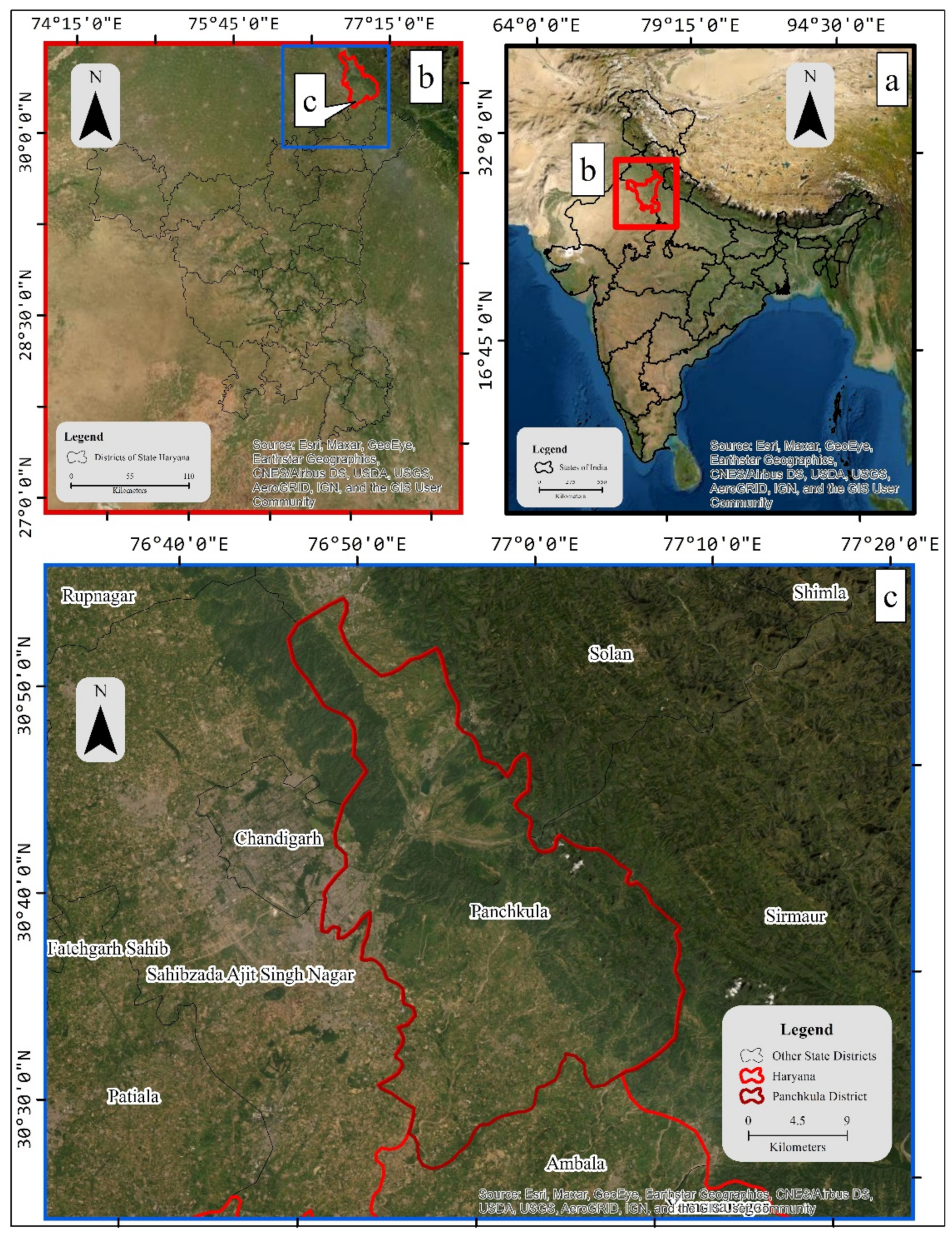
2. Study Area
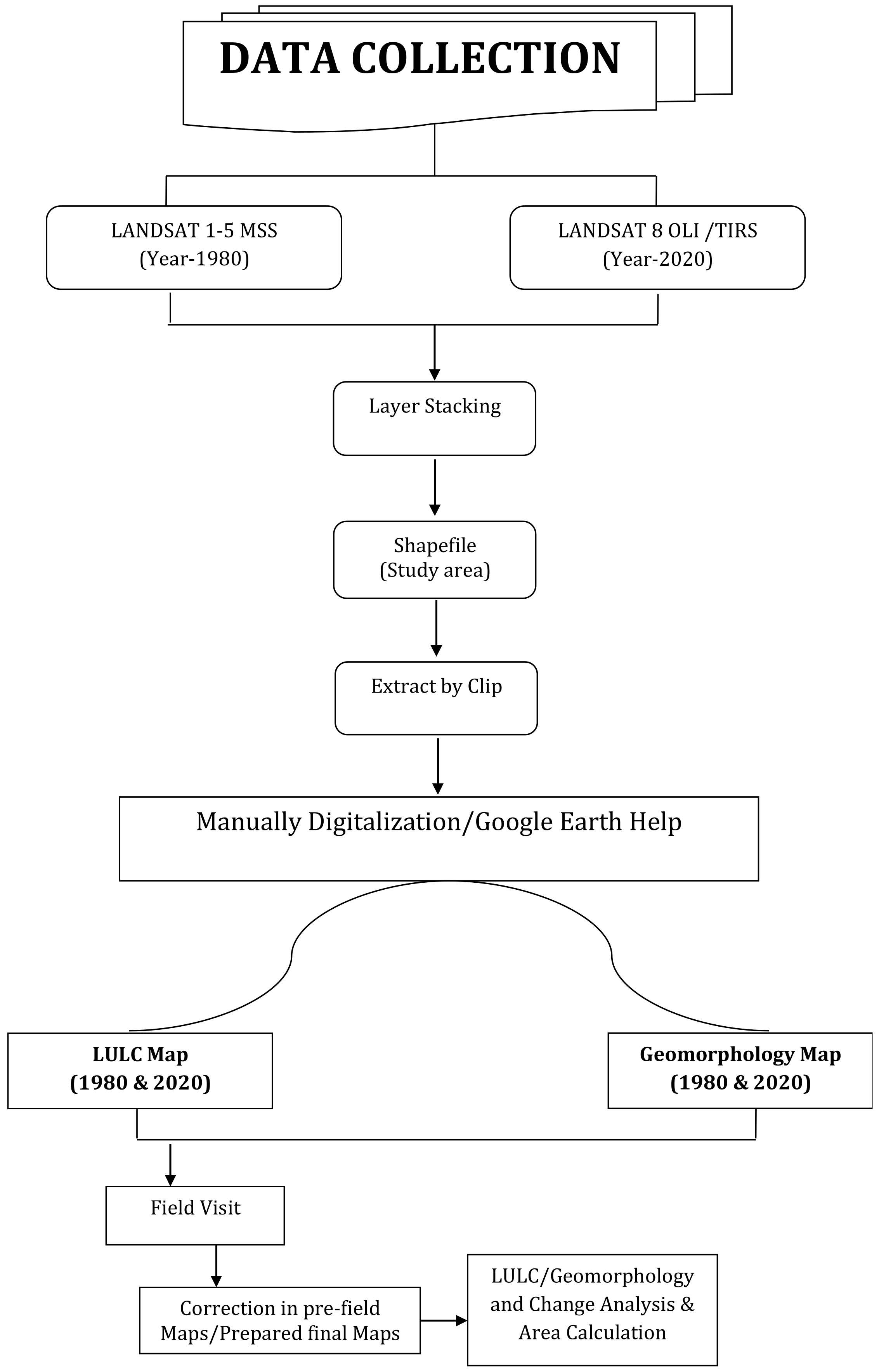
3. Materials and Methods
4. Results and Discussion
5. Conclusions
Author Contributions
Funding
Institutional Review Board Statement
Informed Consent Statement
Data Availability Statement
Acknowledgments
Conflicts of Interest
References
- Zhou, Q.; Zhao, X.; Wu, D.; Tang, R.; Du, X.; Wang, H.; Zhao, J.; Xu, P.; Peng, Y. Impact of Urbanization and Climate on Vegetation Coverage in the Beijing–Tianjin–Hebei Region of China. Remote Sens. 2019, 11, 2452. [Google Scholar] [CrossRef] [Green Version]
- Meraj, G.; Farooq, M.; Singh, S.K.; Islam, N.; Kanga, S. Modeling the sediment retention and ecosystem provisioning services in the Kashmir valley, India, Western Himalayas. Model. Earth Syst. Environ. 2021, 1–26. [Google Scholar] [CrossRef]
- Winkler, K.; Fuchs, R.; Rounsevell, M.; Herold, M. Global land use changes are four times greater than previously estimated. Nat. Commun. 2021, 12, 1–10. [Google Scholar] [CrossRef] [PubMed]
- Allen, M.T.; Vidon, P.G. Impact of Urbanization on Large Wood Sizes and Associated Recruitment Zones. Hydrology 2020, 7, 89. [Google Scholar] [CrossRef]
- Liddle, B. Urbanization and Inequality/Poverty. Urban Sci. 2017, 1, 35. [Google Scholar] [CrossRef] [Green Version]
- Patra, S.; Sahoo, S.; Mishra, P.; Mahapatra, S.C. Impacts of urbanization on land use/cover changes and its probable implications on local climate and groundwater level. J. Urban Manag. 2018, 7, 70–84. [Google Scholar] [CrossRef]
- Bera, A.; Taloor, A.K.; Meraj, G.; Kanga, S.; Singh, S.K.; Đurin, B.; Anand, S. Climate vulnerability and economic determinants: Linkages and risk reduction in Sagar Island, India; A geospatial approach. Quat. Sci. Adv. 2021, 4, 100038. [Google Scholar] [CrossRef]
- Nayak, S.; Maity, S.; Singh, K.S.; Nayak, H.P.; Dutta, S. Influence of the Changes in Land-Use and Land Cover on Temperature over Northern and North-Eastern India. Land 2021, 10, 52. [Google Scholar] [CrossRef]
- Shaban, A.; Kourtit, K.; Nijkamp, P. India’s Urban System: Sustainability and Imbalanced Growth of Cities. Sustainability 2020, 12, 2941. [Google Scholar] [CrossRef] [Green Version]
- Balk, D.; Montgomery, M.R.; Engin, H.; Lin, N.; Major, E.; Jones, B. Urbanization in India: Population and Urban Classification Grids for 2011. Data 2019, 4, 35. [Google Scholar] [CrossRef] [Green Version]
- Rimal, B.; Sloan, S.; Keshtkar, H.; Sharma, R.; Rijal, S.; Shrestha, U.B. Patterns of Historical and Future Urban Expansion in Nepal. Remote Sens. 2020, 12, 628. [Google Scholar] [CrossRef] [Green Version]
- Tomar, J.; Kranjčić, N.; Đurin, B.; Kanga, S.; Singh, S. Forest Fire Hazards Vulnerability and Risk Assessment in Sirmaur District Forest of Himachal Pradesh (India): A Geospatial Approach. ISPRS Int. J. Geo-Inf. 2021, 10, 447. [Google Scholar] [CrossRef]
- Avtar, R.; Tripathi, S.; Aggarwal, A.K.; Kumar, P. Population–Urbanization–Energy Nexus: A Review. Resources 2019, 8, 136. [Google Scholar] [CrossRef] [Green Version]
- Cox, D.T.; Shanahan, D.F.; Hudson, H.L.; Fuller, R.A.; Gaston, K.J. The impact of urbanisation on nature dose and the implications for human health. Landsc. Urban Plan. 2018, 179, 72–80. [Google Scholar] [CrossRef]
- Das, M.; Das, A. Dynamics of Urbanization and its impact on Urban Ecosystem Services (UESs): A study of a medium size town of West Bengal, Eastern India. J. Urban Manag. 2019, 8, 420–434. [Google Scholar] [CrossRef]
- Ha, N.M.; Le, N.D.; Trung-Kien, P. The Impact of Urbanization on Income Inequality: A Study in Vietnam. J. Risk Financ. Manag. 2019, 12, 146. [Google Scholar] [CrossRef] [Green Version]
- Diao, B.; Ding, L.; Zhang, Q.; Na, J.; Cheng, J. Impact of Urbanization on PM2.5-Related Health and Economic Loss in China 338 Cities. Int. J. Environ. Res. Public Health 2020, 17, 990. [Google Scholar] [CrossRef] [PubMed] [Green Version]
- Dimitrova, R.; Danchovski, V.; Egova, E.; Vladimirov, E.; Sharma, A.; Gueorguiev, O.; Ivanov, D. Modeling the Impact of Urbanization on Local Meteorological Conditions in Sofia. Atmosphere 2019, 10, 366. [Google Scholar] [CrossRef] [Green Version]
- Anwar, A.; Younis, M.; Ullah, I. Impact of Urbanization and Economic Growth on CO2 Emission: A Case of Far East Asian Countries. Int. J. Environ. Res. Public Health 2020, 17, 2531. [Google Scholar] [CrossRef] [Green Version]
- Gupta, K.; Hall, R.P. Understanding the What, Why, and How of Becoming a Smart City: Experiences from Kakinada and Kanpur. Smart Cities 2020, 3, 232–247. [Google Scholar] [CrossRef] [Green Version]
- Joy, J.; Kanga, S.; Singh, S.K.; Sudhanshu, S. Cadastral level Soil and Water conservation Priority Zonation using Geospatial technology. Int. J. Agric. Syst. 2021, 9, 10–26. [Google Scholar]
- Kanga, S.; Rather, M.A.; Farooq, M.; Singh, S.K. GIS Based Forest Fire Vulnerability Assessment and its Validation using field and MODIS Data: A Case Study of Bhaderwah Forest Division, Jammu and Kashmir (India). Indian For. 2021, 147, 120–136. [Google Scholar]
- Kumar, A.; Kanga, S.; Taloor, A.K.; Singh, S.K.; Đurin, B. Surface runoff estimation of Sind river basin using integrated SCS-CN and GIS techniques. HydroResearch 2021, 4, 61–74. [Google Scholar] [CrossRef]
- Meraj, G.; Romshoo, S.A.; Yousuf, A.R. Geoinformatics approach to qualitative forest density loss estimation and protection cum conservation strategy-a case study of Pir Panjal range, J&K, India. Int. J. Curr. Res. Rev. 2012, 4, 47–61. [Google Scholar]
- Coppin, P.R.; Bauer, M.E. Digital change detection in forest ecosystems with remote sensing imagery. Remote Sens. Rev. 1996, 13, 207–234. [Google Scholar] [CrossRef]
- Jamali, A.A.; Kalkhajeh, R.G. Urban environmental and land cover change analysis using the scatter plot, kernel, and neural network methods. Arab. J. Geosci. 2019, 12, 100. [Google Scholar] [CrossRef]
- Michener, W.K.; Houhoulis, P.F. Detection of vegetation changes associated with extensive flooding in a forested ecosystem. Photogramm. Eng. Remote Sens. 1997, 63, 1363–1374. [Google Scholar]
- Castilla, G. Object-Oriented Analysis of Remote Sensing Images for Land Cover Mapping: Conceptual Foundations and a Segmentation Method to Derive a Baseline Partition for Classification. Ph.D. Thesis, Polythecnic University of Madrid, Madrid, Spain, 2003. [Google Scholar]
- Mastronuzzi, G.; Aringoli, D.; Aucelli, P.P.; Baldassarre, M.A.; Bellotti, P.; Bini, M.; Biolchi, S.; Bontempi, S.; Brandolini, P.; Chelli, A.; et al. Geomorphological map of the Italian coast: From a descriptive to a morphodynamic approach. Geogr. Fis. Din. Quat. 2017, 40, 161–196. [Google Scholar]
- Dytham, C. Land Mosaics. The Ecology of Landscapes and Regions; JSTOR: New York, NY, USA, 1996. [Google Scholar]
- Brannan, S.; Birch, J. Settlement Ecology at Singer-Moye: Mississippian History and Demography in the Southeastern United States. In Settlement Ecology of the Ancient Americas; Routledge: Oxfordshire, UK, 2016; pp. 69–96. [Google Scholar]
- Wang, L.; Lyons, J.; Kanehl, P.; Bannerman, R. Impacts of Urbanization on Stream Habitat and Fish Across Multiple Spatial Scales. Environ. Manag. 2001, 28, 255–266. [Google Scholar] [CrossRef]
- Barbero-Sierra, C.; Marques, M.J.; Ruíz-Pérez, M. The case of urban sprawl in Spain as an active and irreversible driving force for desertification. J. Arid Environ. 2013, 90, 95–102. [Google Scholar] [CrossRef]
- Carruthers, J.I.; Ulfarsson, G.F. Urban Sprawl and the Cost of Public Services. Environ. Plan. B Plan. Des. 2003, 30, 503–522. [Google Scholar] [CrossRef]
- Pingali, P. Agricultural growth and economic development: A view through the globalization lens. Agric. Econ. 2007, 37, 1–12. [Google Scholar] [CrossRef] [Green Version]
- Birkeland, J. Design for Sustainability: A Sourcebook of Integrated, Eco-Logical Solutions; Earthscan: London, UK, 2002. [Google Scholar]
- Dijoo, Z.K. Urban Heat Island Effect Concept and Its Assessment Using Satellite—Based Remote Sensing Data. Geogr. Inf. Sci. Land Resour. Manag. 2021, 81–98. [Google Scholar] [CrossRef]
- Hossain, M.S.; Santhanam, A.; Norulaini, N.N.; Omar, A.M. Clinical solid waste management practices and its impact on human health and environment—A review. Waste Manag. 2011, 31, 754–766. [Google Scholar] [CrossRef]
- Pall, I.A.; Meraj, G.; Romshoo, S.A. Applying integrated remote sensing and field-based approach to map glacial landform features of the Machoi Glacier valley, NW Himalaya. SN Appl. Sci. 2019, 1, 488. [Google Scholar] [CrossRef] [Green Version]
- Meraj, G.; Singh, S.K.; Kanga, S.; Islam, N. Modeling on comparison of ecosystem services concepts, tools, methods and their ecological-economic implications: A review. Model. Earth Syst. Environ. 2021, 1–20. [Google Scholar] [CrossRef]
- Meraj, G. Ecosystem service provisioning–underlying principles and techniques. SGVU J. Clim. Chang. Water 2020, 7, 56–64. [Google Scholar]
- Meraj, G.; Kanga, S.; Kranjčić, N.; Đurin, B.; Singh, S.K. Role of Natural Capital Economics for Sustainable Management of Earth Resources. Earth 2021, 2, 36. [Google Scholar] [CrossRef]
- Shukla, A.K.; Ojha, C.S.P.; Mijic, A.; Buytaert, W.; Pathak, S.; Garg, R.D.; Shukla, S. Population growth, land use and land cover transformations, and water quality nexus in the Upper Ganga River basin. Hydrol. Earth Syst. Sci. 2018, 22, 4745–4770. [Google Scholar] [CrossRef] [Green Version]


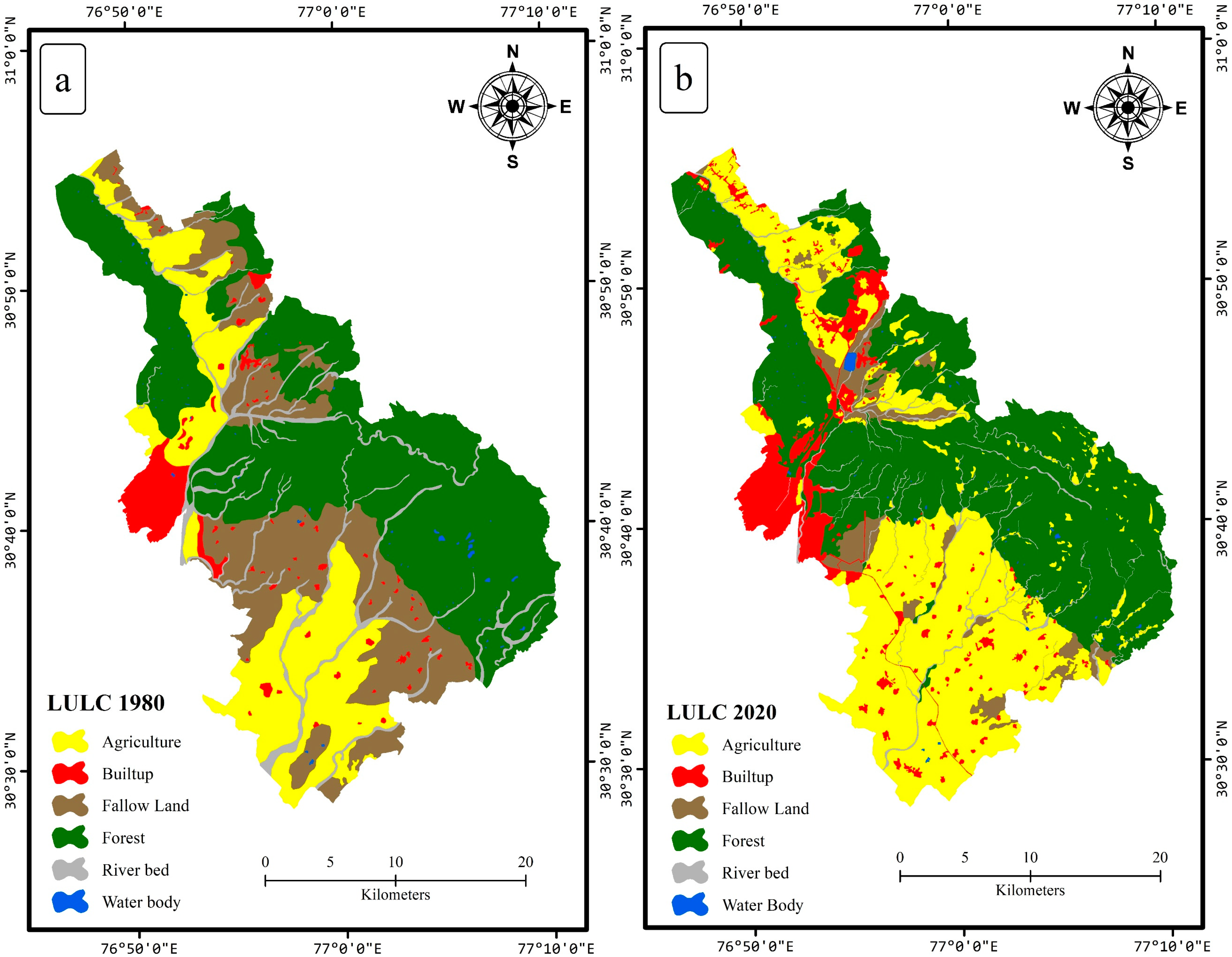
| Land Use/Land Cover | Area in 1980 (sq. km) | Area in 2020 (sq. km) | % Change in LULC (1980–2020) |
|---|---|---|---|
| Built-up land | 38.93 | 71.89 | +84.66 |
| Agriculture | 181.37 | 315.06 | +73.71 |
| Fallow land | 200.18 | 46.45 | −76.80 |
| Forest | 402.95 | 419.33 | +4.07 |
| Water body | 2.22 | 2.73 | +22.97 |
| Riverbed | 55.76 | 27.40 | −50.86 |
| Total | 882.92 | 882.92 |
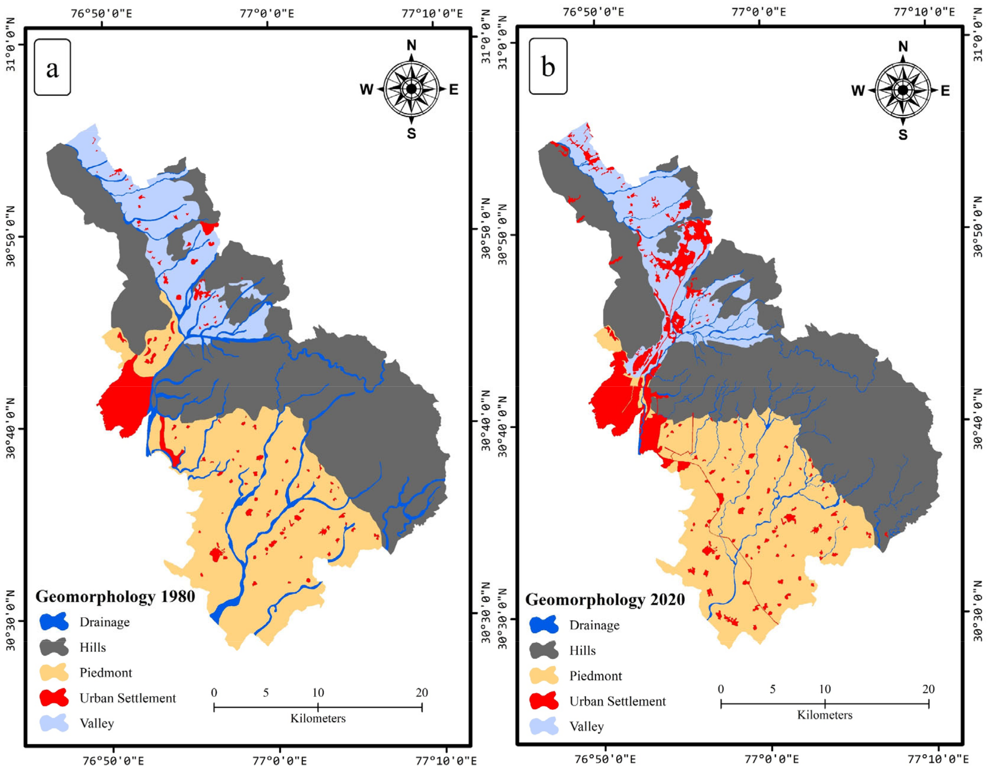
| Geomorphology Classes | Area in 1980 (sq. km) | Area in 2020 (sq. km) | % Change in LULC (1980–2020) |
|---|---|---|---|
| Hills | 403.35 | 393.33 | −2.48 |
| Piedmont | 277.98 | 286.36 | +3.01 |
| Valley | 107.17 | 107.17 | 0.00 |
| Drainage | 55.49 | 24.30 | −56.21 |
| Urban Settlement | 38.93 | 71.89 | +84.66 |
| Total | 882.92 | 882.92 |
Publisher’s Note: MDPI stays neutral with regard to jurisdictional claims in published maps and institutional affiliations. |
© 2022 by the authors. Licensee MDPI, Basel, Switzerland. This article is an open access article distributed under the terms and conditions of the Creative Commons Attribution (CC BY) license (https://creativecommons.org/licenses/by/4.0/).
Share and Cite
Kanga, S.; Singh, S.K.; Meraj, G.; Kumar, A.; Parveen, R.; Kranjčić, N.; Đurin, B. Assessment of the Impact of Urbanization on Geoenvironmental Settings Using Geospatial Techniques: A Study of Panchkula District, Haryana. Geographies 2022, 2, 1-10. https://doi.org/10.3390/geographies2010001
Kanga S, Singh SK, Meraj G, Kumar A, Parveen R, Kranjčić N, Đurin B. Assessment of the Impact of Urbanization on Geoenvironmental Settings Using Geospatial Techniques: A Study of Panchkula District, Haryana. Geographies. 2022; 2(1):1-10. https://doi.org/10.3390/geographies2010001
Chicago/Turabian StyleKanga, Shruti, Suraj Kumar Singh, Gowhar Meraj, Anup Kumar, Ruby Parveen, Nikola Kranjčić, and Bojan Đurin. 2022. "Assessment of the Impact of Urbanization on Geoenvironmental Settings Using Geospatial Techniques: A Study of Panchkula District, Haryana" Geographies 2, no. 1: 1-10. https://doi.org/10.3390/geographies2010001
APA StyleKanga, S., Singh, S. K., Meraj, G., Kumar, A., Parveen, R., Kranjčić, N., & Đurin, B. (2022). Assessment of the Impact of Urbanization on Geoenvironmental Settings Using Geospatial Techniques: A Study of Panchkula District, Haryana. Geographies, 2(1), 1-10. https://doi.org/10.3390/geographies2010001