

Climbing through Climate Change in the Canadian Rockies: Guides’ Experiences of Route Transformation on Mt. Athabasca

Abstract
:1. Introduction
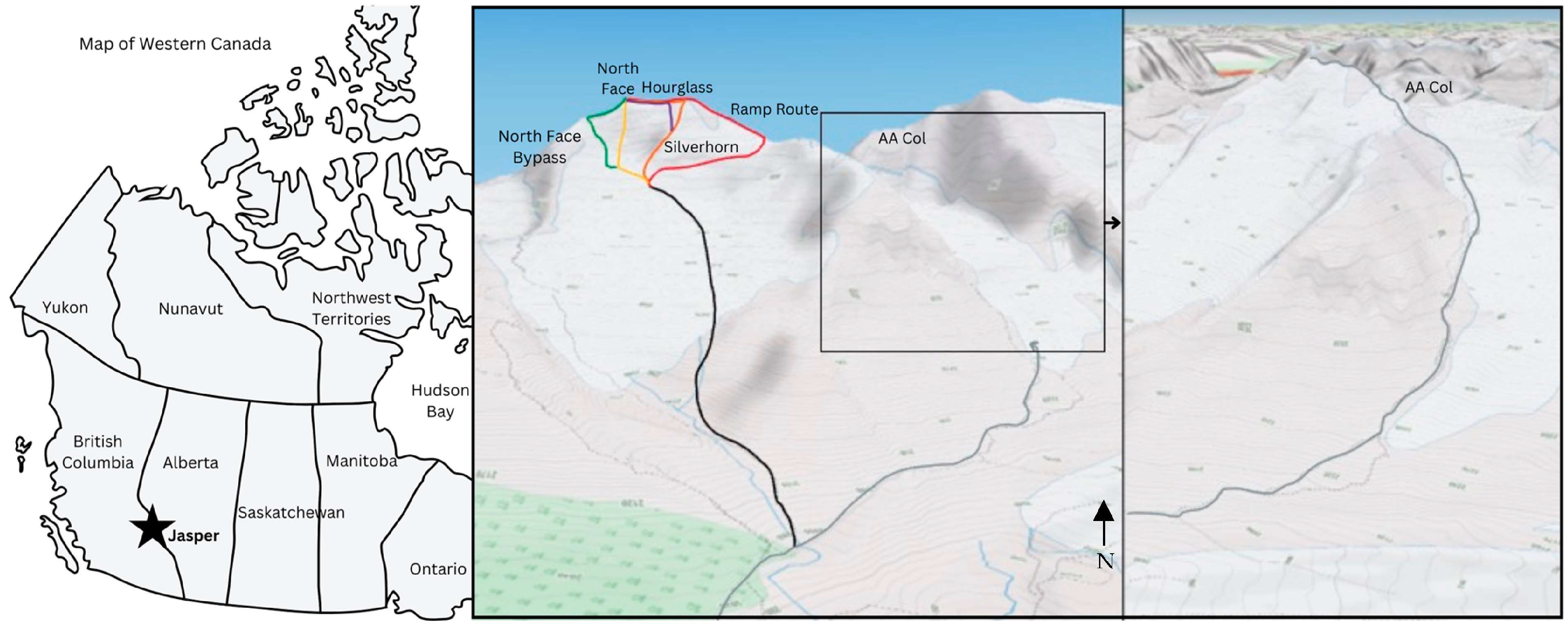
2. Study Area
3. Methods
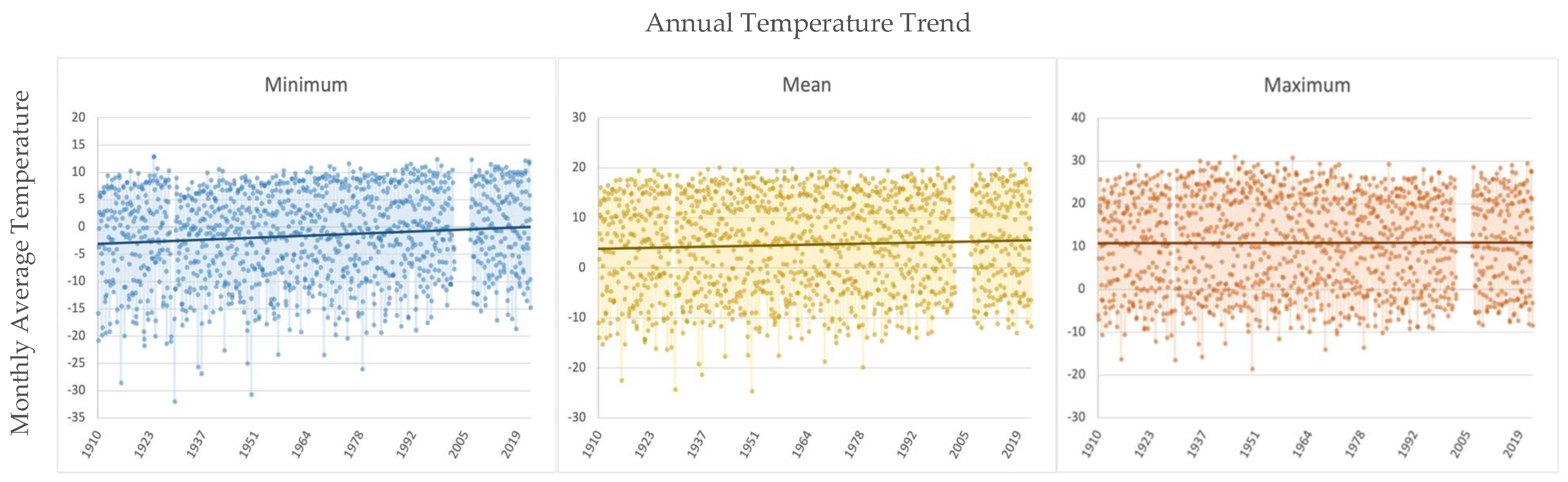
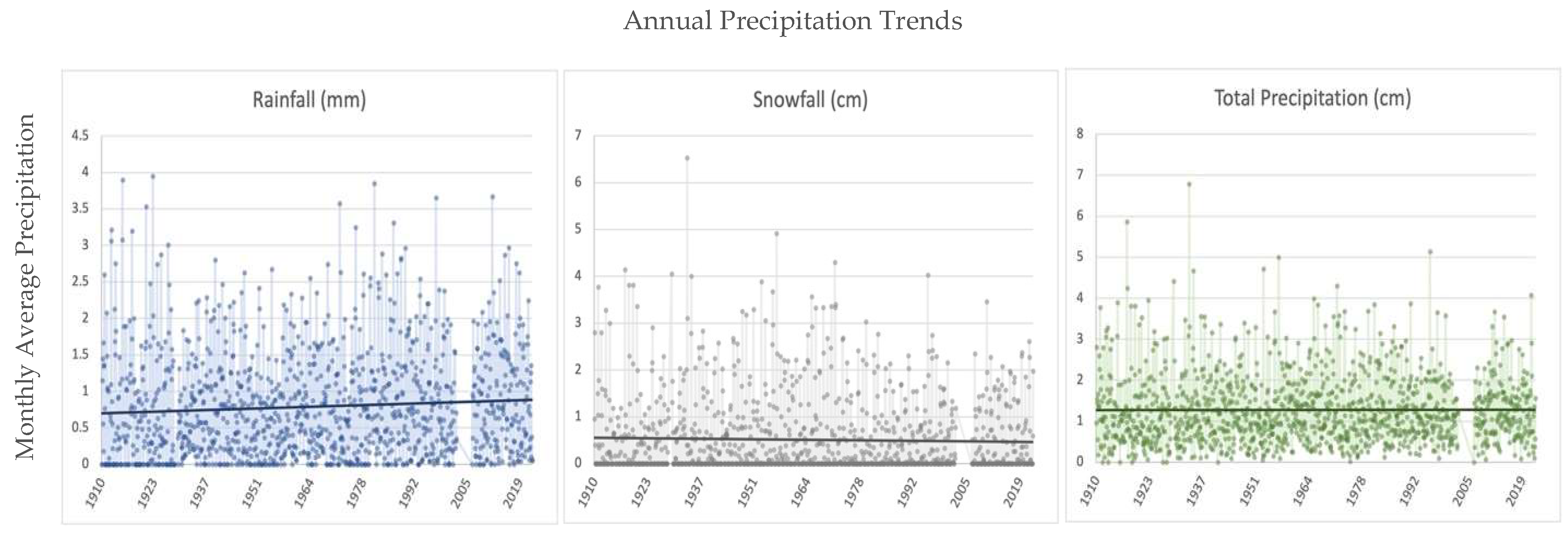
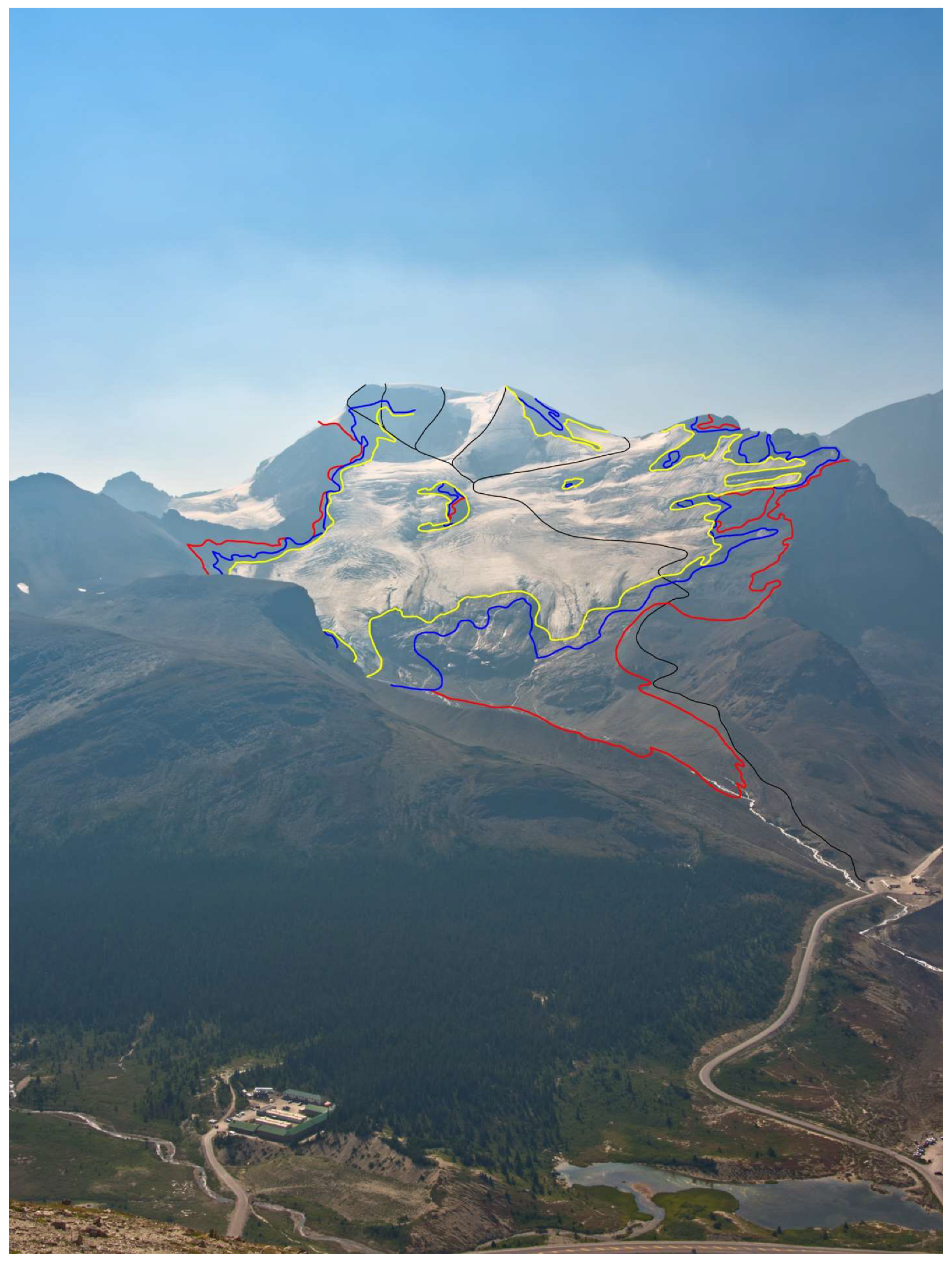
3.1. Spatio-Temporal Trend Analysis
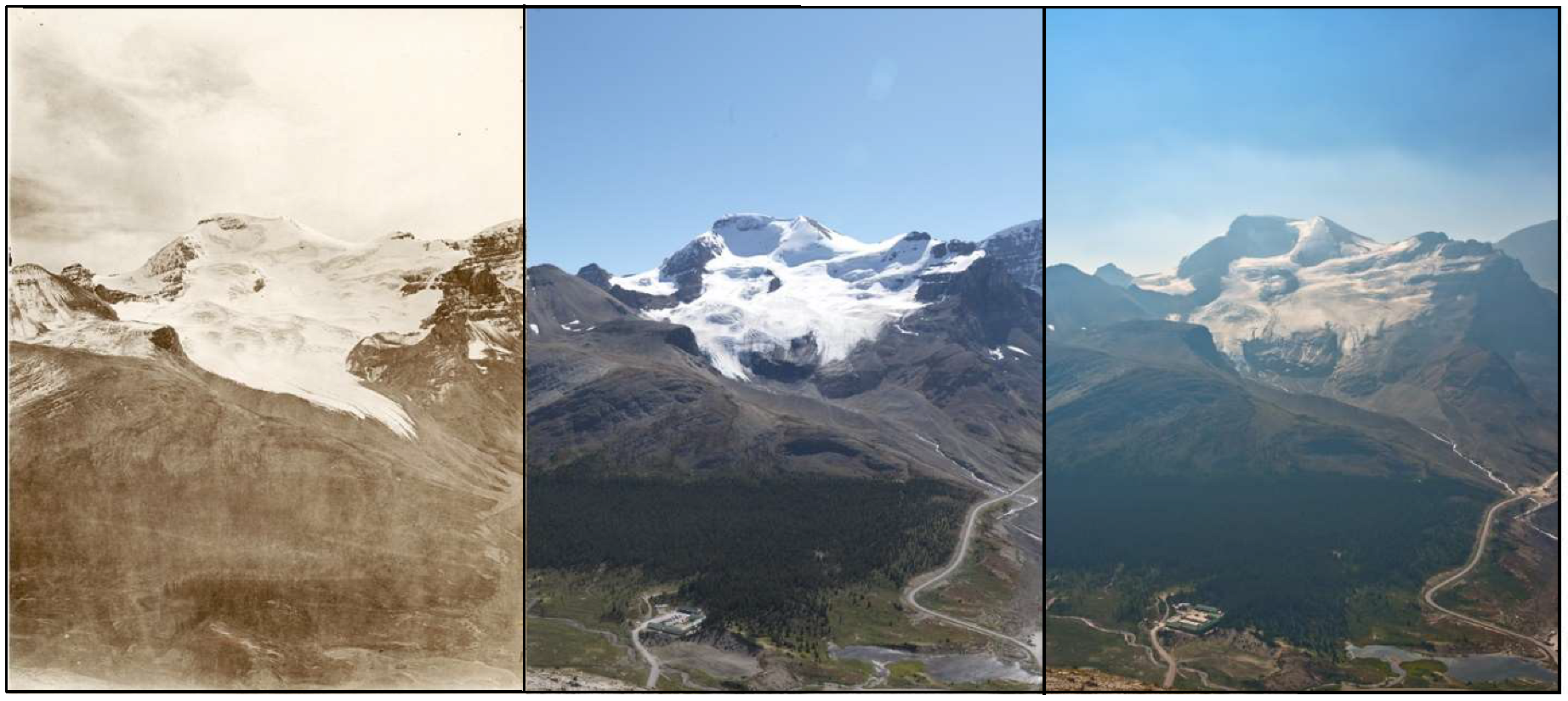
3.2. Repeat Photography
3.3. Semi-Structured Interviews with Mountain Guides
4. Results & Discussion
4.1. Climatological Conditions at Mt. Athabasca Are Changing Rapidly
4.2. Changing Climatic Conditions Are Transforming Climbing Routes on Mt. Athabasca
4.3. Changing Route Conditions Are Impacting Guiding Activities
“The lower North Athabasca glacier, places that the glacier used to be, and where I used to ice climb, now it’s an ablating edge of a glacier… so now we walk up on rock for another, oh man, I don’t know, 300–400 m before we get to the place where we even have ice.”(G14)
“The Athabasca Andromeda glacier… that edge of ice is gone now and places that we used to teach ice climbing [on] the glacier is back 100 m or more 200 m and it’s thinned out [so] as you get up to that place now where we used to rope up… and start our travel… Now that’s rock and the glacier is way over there.”(G14)
“And for the last 10 years or 20 years, we’ve been doing the North Face Bypass, which you get to towards the base of the face, but you go left into gullies that come off of the traditional route up Athabasca… We were able to do it in good conditions and short rope the whole thing. Just keep people moving and put in a nice row of steps in the right snow conditions. I don’t know if those snow conditions will exist again because the ice is gone. Now in those gully and it’s rock. So will we ever be able to do that?”(G14)
“The North Face of Athabasca, the first time I climbed it I think was in 1981 and there was 10 ft to 15 ft of rock exposed, and it was 5.5 rock, and it was quite reasonable… Now I bet it’s like 100 m of rock exposed and it’s no longer 5.5. The last time I guided that I was definitely dry tooling and… it was a search for gear where there used to be ice screw [placements], where you could sink in right to below the face in the 1980s. Now we need stubbies [because there is] not enough ice depth. That’s quite a serious ascent.”(G14)
“You used to go climb the North face of Athabasca all through the summer on snow and now you kind of want to get it June or maybe even May, May/June when there’s snow.”(G9)
“Mount Athabasca has a north face route that used to have a small rock step and when I left in early like 2004, it was already a much bigger rock step. And I think just generally what we’re seeing with features like that is the amount of glacial recession on these faces has exposed a lot of loose rock. So, now I actually avoid that route, certainly in the heat and certain times of the years, I just would not venture onto that route because of the rockfall.”(G30)
“There’s definitely more rockfall for sure because the faces are melting out. Like the Silverhorn now has rocks sticking through it all over the place.”(G15)
“The rockfall hazard, it’s gone from a manageable problem if you get up really early and have a cold night too. But there is no such thing as a cold night for all of June, July, August, September anymore, you can be guaranteed it won’t freeze. So, then it’s doesn’t matter what time you go, it’s just you’re dodging missiles the whole time, which is pretty hard to justify too.”(G12)
“I could try to come up with an alternate, a good alternate plan B to Mount Athabasca. And there’s like there’s nothing, like where do you go? I don’t know, I don’t know where you go. I mean, especially in the conditions, if the general conditions in the range are such that Mt. Athabasca is not a reasonable objective, then where else would you go? I don’t know. Up onto the Wapta Icefield maybe, but that’s not doable in a day. That’s a multiday trip right away, staying at the Bow Hut or something. And otherwise, yeah, where do you go?”(G22)
“We’ve got an alpine ice climbing course that we use to teach people the skills that they would need to know to do big north faces on alpine ice routes, like the north face of Athabasca and that sort of thing. And we really have to either change the venues [North Glacier] that we used to use to be able to teach people those skills or change the venues [Mt. Athabasca] that we use for the actual summit days.”(G13)
“I personally kind of wonder how valuable those skills even are because alpine ice climbing is kind of, it’s just, it’s shrunken to a very limited number of routes with a very limited time window. And I kind of wonder if that’s even gonna be a thing in years to come.”(G13)
“What is Mt. Athabasca going to look like in 20 years?... Our climbing history isn’t super long here in Canada. We’re looking at maybe getting close to 150 years of mountaineering history and for generations these big features are what the Pioneers or the godfathers of the climbing world would have been climbing. And the new guides of the new era, they will look up at those features and be like, ‘oh man, I wish I could have done that. That would have been so awesome.’ But now those features are turning into just nasty rock faces.”(G6)
4.4. Study Limitations
5. Conclusions
Author Contributions
Funding
Institutional Review Board Statement
Informed Consent Statement
Data Availability Statement
Acknowledgments
Conflicts of Interest
References
- Buckley, R.; Coghlan, A. Nature-Based Tourism in Breadth and Depth. In Critical Debates in Tourism; Singh, T., Ed.; Channel View Publications: Bristol, UK, 2012; pp. 304–306. [Google Scholar]
- UNWTO. Glossary of Tourism Terms. Available online: https://www.unwto.org/glossary-tourism-terms (accessed on 17 October 2022).
- FAO; UNWTO (Eds.) Understanding and Quantifying Mountain Tourism; World Tourism Organization (UNWTO): Madrid, Spain, 2023. [Google Scholar] [CrossRef]
- Vespestad, M.K.; Lindberg, F.; Mossberg, L. Value in tourist experiences: How nature-based experiential styles influence value in climbing. Tour. Stud. 2019, 19, 453–474. [Google Scholar] [CrossRef]
- Beedie, P. Mountain guiding and adventure tourism: Reflections on the choreography of the experience. Leis. Stud. 2003, 22, 147–167. [Google Scholar] [CrossRef]
- Pomfret, G. Mountaineering adventure tourists: A conceptual framework for research. Tour. Manag. 2006, 27, 113–123. [Google Scholar] [CrossRef]
- Rokenes, A.; Schumann, S.; Rose, J. The Art of Guiding in Nature-Based Adventure Tourism—How Guides Can Create Client Value and Positive Experiences on Mountain Bike and Backcountry Ski Tours. Scand. J. Hosp. Tour. 2015, 15 (Suppl. S1), 62–82. [Google Scholar] [CrossRef]
- Pörtner, H.O.; Roberts, D.C.; Adams, H.; Adler, C.; Aldunce, P.; Ali, E.; Ara Begum, R.; Betts, R.; Bezner Kerr, R.; Biesbroek, R.; et al. Climate Change 2022: Impacts, Adaptation and Vulnerability; Sixth Assess Report; IPCC: Geneva, Switzerland, 2022. [Google Scholar]
- Pepin, N.; Bradley, R.S.; Diaz, H.F.; Baraer, M.; Caceres, E.B.; Forsythe, N.; Fowler, H.; Greenwood, G.; Hashmi, M.Z.; Liu, X.D.; et al. Elevation-dependent warming in mountain regions of the world. Nat. Clim. Chang. 2015, 5, 424–430. [Google Scholar] [CrossRef]
- Pörtner, H.O.; Roberts, D.C.; Adams, H.; Adler, C.; Aldunce, P.; Ali, E.; Ara Begum, R.; Betts, R.; Bezner Kerr, R.; Biesbroek, R.; et al. High Mountain Areas Chapter—IPCC Special Report on the Oceans and Cryosphere in a Changing Climate (SROCC); Cambridge University Press: Cambridge, UK; New York, NY, USA, 2019; Available online: https://www.ipcc.ch/srocc/chapter/chapter-2/ (accessed on 2 July 2023).
- Biskaborn, B.K.; Smith, S.L.; Noetzli, J.; Matthes, H.; Vieira, G.; Streletskiy, D.A.; Schoeneich, P.; Romanovsky, V.E.; Lewkowicz, A.G.; Abramov, A.; et al. Permafrost is warming at a global scale. Nat. Commun. 2019, 10, 264. [Google Scholar] [CrossRef]
- Mourey, J.; Perrin-Malterre, C.; Ravanel, L. Strategies used by French Alpine guides to adapt to the effects of climate change. J. Outdoor Recreat. Tour. 2020, 29, 100278. [Google Scholar] [CrossRef]
- Rushton, B.; Rutty, M. Gaining insight from the most challenging expedition: Climate change from the perspective of Canadian mountain guides. Curr. Issues Tour. 2023, 26, 1–13. [Google Scholar] [CrossRef]
- Voorhis, J.; McDowell, G.; Burakowski, E.; Luneau, T. The implications of warmer winters for ice climbing: A case study of the Mount Washington Valley, New Hampshire, USA. Front. Hum. Dyn. 2023, 5, 1097414. Available online: https://www.frontiersin.org/articles/10.3389/fhumd.2023.1097414 (accessed on 7 April 2023). [CrossRef]
- Mourey, J.; Marcuzzi, M.; Ravanel, L.; Pallandre, F. Effects of climate change on high Alpine mountain environments: Evolution of mountaineering routes in the Mont Blanc massif (Western Alps) over half a century. Arct. Antarct. Alp. Res. 2019, 51, 176–189. [Google Scholar] [CrossRef]
- Purdie, H.; Kerr, T. Aoraki Mount Cook: Environmental Change on an Iconic Mountaineering Route. Mt. Res. Dev. 2018, 38, 364. [Google Scholar] [CrossRef]
- Ritter, F.; Fiebig, M.; Muhar, A. Impacts of Global Warming on Mountaineering: A Classification of Phenomena Affecting the Alpine Trail Network. Mt. Res. Dev. 2012, 32, 4–15. [Google Scholar] [CrossRef]
- Watson, C.S.; King, O. Everest’s thinning glaciers: Implications for tourism and mountaineering. Geol. Today 2018, 34, 18–25. [Google Scholar] [CrossRef]
- Gruber, S.; Haeberli, W. Permafrost in steep bedrock slopes and its temperature-related destabilization following climate change. J. Geophys. Res. Earth Surf. 2007, 112, F2. [Google Scholar] [CrossRef]
- Ravanel, L.; Magnin, F.; Deline, P. Impacts of the 2003 and 2015 summer heatwaves on permafrost-affected rock-walls in the Mont Blanc massif. Sci. Total Environ. 2017, 609, 132–143. [Google Scholar] [CrossRef]
- Ravanel, L.; Deline, P. Climate influence on rockfalls in high-Alpine steep rockwalls: The north side of the Aiguilles de Chamonix (Mont Blanc massif) since the end of the ‘Little Ice Age’. Holocene 2011, 21, 357–365. [Google Scholar] [CrossRef]
- Temme, A.J.A.M. Using climber’s guidebooks to assess rock fall patterns over large spatial and decadal temporal scales: An example from the swiss alps. Geogr. Ann. Ser. Phys. Geogr. 2015, 97, 793–807. [Google Scholar] [CrossRef]
- Duvillard, P.-A.; Ravanel, L.; Marcer, M.; Schoeneich, P. Recent evolution of damage to infrastructure on permafrost in the French Alps. Reg. Environ. Chang. 2019, 19, 1281–1293. [Google Scholar] [CrossRef]
- Duvillard, P.-A.; Ravanel, L.; Schoeneich, P.; Deline, P.; Marcer, M.; Magnin, F. Qualitative risk assessment and strategies for infrastructure on permafrost in the French Alps. Cold Reg. Sci. Technol. 2021, 189, 103311. [Google Scholar] [CrossRef]
- McColl, S.T.; Davies, T.R.H. Large ice-contact slope movements: Glacial buttressing, deformation and erosion. Earth Surf. Process. Landf. 2013, 38, 1102–1115. [Google Scholar] [CrossRef]
- Driver, G. Fractured Landscape. Wilderness Magazine. Available online: https://www.wildernessmag.co.nz/fractured-landscape/ (accessed on 6 December 2021).
- Goverment of Canada Parks Canada Agency. About—Abbot Pass Refuge Cabin National Historic Site. Available online: https://parks.canada.ca/pn-np/bc/yoho/culture/~/link.aspx?_id=0AF382BB05604F859137C177303C8CD2&_z=z (accessed on 8 December 2022).
- Salim, E.; Mourey, J.; Ravanel, L.; Picco, P.; Gauchon, C. Mountain guides facing the effects of climate change. What perceptions and adaptation strategies at the foot of Mont Blanc? Rev. Géograph. Alp. 2019, 107, 1–14. [Google Scholar] [CrossRef]
- Mourey, J.; Ravanel, L.; Lambiel, C. Climate change related processes affecting mountaineering itineraries, mapping and application to the Valais Alps (Switzerland). Geogr. Ann. Ser. Phys. Geogr. 2022, 104, 109–126. [Google Scholar] [CrossRef]
- Ford, J.D.; Keskitalo, E.C.H.; Smith, T.; Pearce, T.; Berrang-Ford, L.; Duerden, F.; Smit, B. Case study and analogue methodologies in climate change vulnerability research: Climate change vulnerability research. Wiley Interdiscip. Rev. Clim. Chang. 2010, 1, 374–392. [Google Scholar] [CrossRef]
- Smit, B.; Wandel, J. Adaptation, adaptive capacity and vulnerability. Glob. Environ. Chang. 2006, 16, 282–292. [Google Scholar] [CrossRef]
- Adger, W.N. Vulnerability. Glob. Environ. Chang. 2006, 16, 268–281. [Google Scholar] [CrossRef]
- Engle, N.L. Adaptive capacity and its assessment. Glob. Environ. Chang. 2011, 21, 647–656. [Google Scholar] [CrossRef]
- Squire, S.J. In the Steps of ‘Genteel Ladies’: Women Tourists in the Canadian Rockies, 1885–1939. Can. Geogr. Géographe Can. 1995, 39, 2–15. [Google Scholar] [CrossRef]
- Goverment of Canada Parks Agency. A Brief History of the Icefields Parkway. Available online: https://parks.canada.ca/pn-np/ab/jasper/activ/itineraires-itineraries/promenadedesglaciers-icefieldsparkway/PGhistoire-IPhistory (accessed on 18 July 2023).
- Jones, D. Rockies West: The Climber’s Guide to the Rocky Mountains of Canada, 3rd ed.; Thin Gruel: Golden, BC, Canada, 2018; Volume 3. [Google Scholar]
- Cheesmond, D. Starlight and Storm: The Great North Faces of the Rockies. Mountain 1984, 98, 18–19. [Google Scholar]
- Pullan, B. The Bold and Cold: A History of 25 Classic Climbs in the Canadian Rockies; RMB Rocky Mountain Books: Victoria, BC, Canada, 2016; Available online: http://ebookcentral.proquest.com/lib/ucalgary-ebooks/detail.action?docID=5107007 (accessed on 30 May 2022).
- McDowell, G.; Huggel, C.; Frey, H.; Wang, F.M.; Cramer, K.; Ricciardi, V. Adaptation action and research in glaciated mountain systems: Are they enough to meet the challenge of climate change? Glob. Environ. Chang. 2019, 54, 19–30. [Google Scholar] [CrossRef]
- Mourey, J.; Lacroix, P.; Duvillard, P.A.; Marsy, G.; Marcer, M.; Ravanel, L.; Malet, E. Rockfall and vulnerability of mountaineers on the west face of the Aiguille du Goûter (classic route up Mont Blanc, France), an interdisciplinary study. Nat. Hazards Earth Syst. Sci. 2021, 128, 1–29. [Google Scholar] [CrossRef]
- Sen, P.K. Estimates of the Regression Coefficient Based on Kendall’s Tau. J. Am. Stat. Assoc. 1968, 63, 1379–1389. [Google Scholar] [CrossRef]
- Pradhananga, D.; Pomeroy, J.W.; Aubry-Wake, C.; Munro, D.S.; Shea, J.; Demuth, M.N.; Kirat, N.H.; Menounos, B.; Mukherjee, K. Hydrometeorological, glaciological and geospatial research data from the Peyto Glacier Research Basin in the Canadian Rockies. Earth Syst. Sci. Data 2021, 13, 2875–2894. [Google Scholar] [CrossRef]
- Webb, R.; Boyer, D.; Turner, R. Repeat Photography: Methods and Applications in the Natural Sciences; Island Press: Washington, DC, USA, 2010. [Google Scholar]
- Baker, B.B.; Moseley, R.K. Advancing Treeline and Retreating Glaciers: Implications for Conservation in Yunnan, P.R. China. Arct. Antarct. Alp. Res. 2007, 39, 200–209. [Google Scholar] [CrossRef]
- Byers, A.C. An assessment of contemporary glacier fluctuations in Nepal’s Khumbu Himal using repeat photography. Himal. J. Sci. 2007, 4, 21–26. [Google Scholar] [CrossRef]
- Kamp, U.; Yager, K.; Arnett, E.; Bowen, K.; Truitt, K.; Seimon, A.; Seimon, T.; Ivanoff, A. Using repeat oblique aerial photography and satellite imagery to detect glacial change in the Cordillera Vilcanota, Peru, since 1931. In Proceedings of the 23rd EGU General Assembly, Online, 19–30 April 2021. [Google Scholar] [CrossRef]
- Kaufmann, V. The evolution of rock glacier monitoring using terrestrial photogrammetry: The example of Äußeres Hochebenkar rock glacier (Austria). Austrian J. Earth Sci. 2012, 105, 63–77. [Google Scholar]
- Masiokas, M.H.; Villalba, R.; Luckman, B.H.; Lascano, M.E.; Delgado, S.; Stepanek, P. 20th-century glacier recession and regional hydroclimatic changes in northwestern Patagonia. Glob. Planet. Chang. 2008, 60, 85–100. [Google Scholar] [CrossRef]
- Molnia, B.F.; Kantor, C.M.; Dilles, S.J.; Angeli, K.M. Documenting 20th and 21st century glacier change and landscape evolution with maps and land, aerial, and space-based geospatial imagery in Alaska’s Kenai Mountains. Nova Geod. 2022, 2, 18. [Google Scholar] [CrossRef]
- Schmidt, S.; Nüsser, M. Fluctuations of Raikot Glacier during the past 70 years: A case study from the Nanga Parbat massif, northern Pakistan. J. Glaciol. 2009, 55, 949–959. [Google Scholar] [CrossRef]
- MacLaren, I.S.; Higgs, E.S.; Zezulka-Mailloux, G.E.M. Mapper of Mountains: M.P. Bridgland in the Canadian Rockies 1902–1930, 1st ed.; University of Alberta Press: Edmonton, AL, Canada, 2005. [Google Scholar]
- Trant, A.J.; Starzomski, B.M.; Higgs, E. A publically available database for studying ecological change in mountain ecosystems. Front. Ecol. Environ. 2015, 13, 187. [Google Scholar] [CrossRef]
- Sanseverino, M.E.; Whitney, M.J.; Higgs, E.S. Exploring Landscape Change in Mountain Environments with the Mountain Legacy Online Image Analysis Toolkit. Mt. Res. Dev. 2016, 36, 407–416. [Google Scholar] [CrossRef]
- Dreimer, R. Diversity, Inclusion, and Mental Health in the Avalanche and Guiding Industry in Canada; Lotus Mountain Consulting Inc.: Revelstoke, BC, Canada, 2019. [Google Scholar]
- Payne, G.; Payne, J. Key Concepts in Social Research; SAGE Publications, Ltd.: London, UK, 2004. [Google Scholar] [CrossRef]
- Downe-Wamboldt, B. Content analysis: Method, applications, and issues. Health Care Women Int. 1992, 13, 313–321. [Google Scholar] [CrossRef] [PubMed]
- Arias, P.; Bellouin, N.; Coppola, E.; Jones, R.; Krinner, G.; Marotzke, J.; Naik, V.; Palmer, M.; Plattner, G.K.; Rogelj, J.; et al. Changing State of the Climate System. In Climate Change 2021: The Physical Science Basis. Contribution of Working Group I to the Sixth Assessment Report of the Intergovernmental Panel on Climate Change, 1st ed.; Masson-Delmotte, V., Zhai, P., Pirani, A., Connors, S.L., Péan, C., Berger, S., Caud, N., Chen, Y., Goldfarb, L., Gomis, M.I., et al., Eds.; Cambridge University Press: Cambridge, UK; New York, NY, USA, 2023. [Google Scholar] [CrossRef]
- Notarnicola, C. Overall negative trends for snow cover extent and duration in global mountain regions over 1982–2020. Sci. Rep. 2022, 12, 13731. [Google Scholar] [CrossRef] [PubMed]
- Kunkel, K.E.; Robinson, D.A.; Champion, S.; Yin, X.; Estilow, T.; Frankson, R.M. Trends and Extremes in Northern Hemisphere Snow Characteristics. Curr. Clim. Chang. Rep. 2016, 2, 65–73. [Google Scholar] [CrossRef]
- Pulliainen, J.; Luojus, K.; Derksen, C.; Mudryk, L.; Lemmetyinen, J.; Salminen, M.; Ikonen, J.; Takala, M.; Cohen, J.; Smolander, T. Patterns and trends of Northern Hemisphere snow mass from 1980 to 2018. Nature 2020, 581, 294–298. [Google Scholar] [CrossRef]
- Mortezapour, M.; Menounos, B.; Jackson, P.L.; Erler, A.R. Future Snow Changes over the Columbia Mountains, Canada, using a Distributed Snow Model. Clim. Chang. 2022, 172, 6. [Google Scholar] [CrossRef]
- Pradhananga, D.; Pomeroy, J.W. Recent hydrological response of glaciers in the Canadian Rockies to changing climate and glacier configuration. Hydrol. Earth Syst. Sci. 2022, 26, 2605–2616. [Google Scholar] [CrossRef]
- Bevington, A.R.; Menounos, B. Accelerated change in the glaciated environments of western Canada revealed through trend analysis of optical satellite imagery. Remote Sens. Environ. 2022, 270, 112862. [Google Scholar] [CrossRef]
- Bolch, T.; Menounos, B.; Wheate, R. Landsat-based inventory of glaciers in western Canada, 1985–2005. Remote Sens. Environ. 2010, 114, 127–137. [Google Scholar] [CrossRef]
- Williamson, S.N.; Menounos, B. The influence of forest fire aerosol and air temperature on glacier albedo, western North America. Remote Sens. Environ. 2021, 267, 112732. [Google Scholar] [CrossRef]
- Hock, R. Glacier melt: A review of processes and their modelling. Prog. Phys. Geogr. Earth Environ. 2005, 29, 362–391. [Google Scholar] [CrossRef]
- Aubry-Wake, C.; Bertoncini, A.; Pomeroy, J.W. Fire and Ice: The Impact of Wildfire-Affected Albedo and Irradiance on Glacier Melt. Earths Future 2022, 10, e2022EF002685. [Google Scholar] [CrossRef]
- Skiles, S.M.; Flanner, M.; Cook, J.M.; Dumont, M.; Painter, T.H. Radiative forcing by light-absorbing particles in snow. Nat. Clim. Chang. 2018, 8, 964–971. [Google Scholar] [CrossRef]
- Mourey, J.; Ravanel, L.; Lambiel, C.; Strecker, J.; Piccardi, M. Access routes to high mountain huts facing climate-induced environmental changes and adaptive strategies in the Western Alps since the 1990s. Nor. Geogr. Tidsskr.-Nor. J. Geogr. 2019, 73, 215–228. [Google Scholar] [CrossRef]
- Mourey, J.; Ravanel, L. Evolution of Access Routes to High Mountain Refuges of the Mer de Glace Basin (Mont Blanc Massif, France): An Example of Adapting to Climate Change Effects in the Alpine High Mountains. Rev. Géograph. Alp. 2017, 105, 1–17. [Google Scholar] [CrossRef]
- Lukas, S. Ice-Cored Moraines. In Encyclopedia of Snow, Ice and Glaciers; Singh, V.P., Singh, P., Haritashya, U.K., Eds.; Encyclopedia of Earth Sciences Series; Springer: Dordrecht, The Netherlands, 2011; pp. 616–619. [Google Scholar] [CrossRef]
- Ravanel, L.; Duvillard, P.; Jaboyedoff, M.; Lambiel, C. Recent evolution of an ice-cored moraine at the Gentianes Pass, Valais Alps, Switzerland. Land Degrad. Dev. 2018, 29, 3693–3708. [Google Scholar] [CrossRef]
- Hale, K.E.; Jennings, K.S.; Musselman, K.N.; Livneh, B.; Molotch, N.P. Recent decreases in snow water storage in western North America. Commun. Earth Environ. 2023, 4, 170. [Google Scholar] [CrossRef]
- Musselman, K.N.; Addor, N.; Vano, J.A.; Molotch, N.P. Winter melt trends portend widespread declines in snow water resources. Nat. Clim. Chang. 2021, 11, 418–424. [Google Scholar] [CrossRef]
- Deline, P.; Hewitt, K.; Shugar, D.; Reznichenko, N. Chapter 9—Rock avalanches onto glaciers. In Landslide Hazards, Risks, and Disasters, 2nd ed.; Davies, T., Rosser, N., Shroder, J.F., Eds.; Hazards and Disasters Series; Elsevier: Amsterdam, The Netherlands, 2022; pp. 269–333. [Google Scholar] [CrossRef]
- Magnin, F.; Josnin, J.-Y.; Ravanel, L.; Pergaud, J.; Pohl, B.; Deline, P. Modelling rock wall permafrost degradation in the Mont Blanc massif from the LIA to the end of the 21st century. Cryosphere 2017, 11, 1813–1834. [Google Scholar] [CrossRef]
- Nigrelli, G.; Chiarle, M.; Merlone, A.; Coppa, G.; Musacchio, C. Rock temperature variability in high-altitude rockfall-prone areas. J. Mt. Sci. 2022, 19, 798–811. [Google Scholar] [CrossRef]
- Ravanel, L.; Deline, P.; Lambiel, C.; Vincent, C. Instability of a high alpine rock ridge: The lower arête des cosmiques, mont blanc massif, france. Geogr. Ann. Ser. Phys. Geogr. 2013, 95, 51–66. [Google Scholar] [CrossRef]
- Le cas du parc National des Ecrins—Bourdeau. Effet du Changement Climatique sur l’alpinisme et Nouvelles Interactions avec la Gestion des Espaces Protégés en Haute Montagne. PACTE. 2014. Available online: http://oai.eauetbiodiversite.fr/entrepotsOAI/PNE/BOURDEAU_chang_clim_alpinisme_2014_13127.pdf (accessed on 8 December 2021).
- Huggel, C.; Muccione, V.; Carey, M.; James, R.; Jurt, C.; Mechler, R. Loss and Damage in the mountain cryosphere. Reg. Environ. Chang. 2019, 19, 1387–1399. [Google Scholar] [CrossRef]
- Debarbieux, B. Imaginaries and rhetorics of ‘globality’ in UNESCO’s intangible cultural heritage. L’Espace Géograph. 2021, 49, 354–370. [Google Scholar] [CrossRef]
- DeBeer, C.M.; Wheater, H.S.; Pomeroy, J.W.; Barr, A.G.; Baltzer, J.L.; Johnstone, J.F.; Turetsky, M.R.; Stewart, R.E.; Hayashi, M.; van der Kamp, G.; et al. Summary and synthesis of Changing Cold Regions Network (CCRN) research in the interior of western Canada—Part 2: Future change in cryosphere, vegetation, and hydrology. Hydrol. Earth Syst. Sci. 2021, 25, 1849–1882. [Google Scholar] [CrossRef]
- Rasmussen, R.; Baker, B.; Kochendorfer, J.; Meyers, T.; Landolt, S.; Fischer, A.P.; Black, J.; Thériault, J.M.; Kucera, P.; Gochis, D.; et al. How Well Are We Measuring Snow: The NOAA/FAA/NCAR Winter Precipitation Test Bed. Bull. Am. Meteorol. Soc. 2012, 93, 811–829. [Google Scholar] [CrossRef]
- Bush, E.; Lemmen, D.S. Canada’s Changing Climate Report; Government of Canada: Ottawa, ON, Canada, 2019. [Google Scholar]
- Clarke, G.K.C.; Jarosch, A.H.; Anslow, F.S.; Radić, V.; Menounos, B. Projected deglaciation of western Canada in the twenty-first century. Nat. Geosci. 2015, 8, 372–377. [Google Scholar] [CrossRef]

| Climb | Grade | Route Description | |
|---|---|---|---|
| Alpine Grade 1 | YDS 2 | ||
| Ramp | PD | Not graded | Traverse across the North Glacier, stopping just before the base of a steep shoulder feature (the Silverhorn). From here, begin a right-trending traverse on a snow ramp, leading to a saddle that connects to the West ridge. The ridge can be followed to a false summit and onto the true summit. (3–6 h from road) |
| Silverhorn | AD- | Not graded | Traverse across the North Glacier, past the Ramp to the base of a steep shoulder. From here, cross the bergschrund and climb 300 m directly up the shoulder on a steep, 40° to 45°, snow and ice slope. The shoulder will give way to a false summit and a ridge which can be taken to the true summit. (4–6 h from road) |
| North Face | D | 5.7–5.8 | Traverse across the North Glacier, past the Silverhorn and into a bowl below the main face. The route begins below a noticeable weakness near the east end of the rock band on the face above. Cross the bergschrund and start directly up the face, towards the weakness. The slope will steadily steepen from 40 to 60-degrees on snow and ice. Near the top trend right, towards the crux, a steeper pitch of mixed climbing, which leads to the summit. |
| North Face Bypass | AD | 5.5 | To the left of the North Face route, cross the bergschrund and climb 6 pitches of steep snow and/or ice to the end of a flatter stretch of the North ridge. Follow the ridge for 3 pitches to the top of a steep rock step, traverse right, to and up the ‘Scottish gully’, connecting to the summit ridge and onto the summit. |
| Hourglass | D | 5.7–5.8 | To the right of the North Face route, follow a steep and narrow ice gully, which forms where the North Face rock band ends and hanging seracs begin, to the top of the Silverhorn. From here, take the ridge to the summit. |
| AA Col | PD | Not graded | From the amphitheatre, scramble up a rock step to gain the AA glacier above the icefall. Staying left, cross the bergschrund and ascend a steepening snow, ice, or scree slope to the AA Col. From the col follow the West ridge to the top of the false summit and onto the true summit. |
| Less Pressure to Work in Hazardous Conditions | More Pressure to Work in Hazardous Conditions | ||||
|---|---|---|---|---|---|
| Count | 22 | 4 | |||
| Average age | 51 | 39 | |||
| Certification | IFMGA | 68% | n = 15 | 25% | n = 1 |
| ACMG | 32% | n = 7 | 75% | n = 3 | |
| Employment status | Independent contractor | 53% | n = 19 | 43% | n = 3 |
| Guide service employee | 47% | n = 17 | 57% | n = 4 | |
| Average years of experience | 24 | 8 | |||
| Average days spent on snow, ice, or glaciated terrain | 103 | 135 | |||
| Guide career stage | Late-career guides | Early-career guides | |||
Disclaimer/Publisher’s Note: The statements, opinions and data contained in all publications are solely those of the individual author(s) and contributor(s) and not of MDPI and/or the editor(s). MDPI and/or the editor(s) disclaim responsibility for any injury to people or property resulting from any ideas, methods, instructions or products referred to in the content. |
© 2023 by the authors. Licensee MDPI, Basel, Switzerland. This article is an open access article distributed under the terms and conditions of the Creative Commons Attribution (CC BY) license (https://creativecommons.org/licenses/by/4.0/).
Share and Cite
Hanly, K.; McDowell, G.; Tricker, J. Climbing through Climate Change in the Canadian Rockies: Guides’ Experiences of Route Transformation on Mt. Athabasca. Tour. Hosp. 2023, 4, 539-558. https://doi.org/10.3390/tourhosp4040033
Hanly K, McDowell G, Tricker J. Climbing through Climate Change in the Canadian Rockies: Guides’ Experiences of Route Transformation on Mt. Athabasca. Tourism and Hospitality. 2023; 4(4):539-558. https://doi.org/10.3390/tourhosp4040033
Chicago/Turabian StyleHanly, Katherine, Graham McDowell, and James Tricker. 2023. "Climbing through Climate Change in the Canadian Rockies: Guides’ Experiences of Route Transformation on Mt. Athabasca" Tourism and Hospitality 4, no. 4: 539-558. https://doi.org/10.3390/tourhosp4040033
APA StyleHanly, K., McDowell, G., & Tricker, J. (2023). Climbing through Climate Change in the Canadian Rockies: Guides’ Experiences of Route Transformation on Mt. Athabasca. Tourism and Hospitality, 4(4), 539-558. https://doi.org/10.3390/tourhosp4040033