1. Introduction
Mining activities significantly impact the environment and often determine anxiety in the local population. Diamond mining in Siberia is the most ambitious and impressive, since the primary diamond deposits are associated with vertical pipe-like kimberlite geological bodies that go to a depth of many kilometers. Therefore, their development leads to the formation of deep cone-shaped open pits. For example, at the Udachny quarry, open-pit mining was completed at a depth of 640 m, and the size of the quarry on the surface is 2000 × 1600 m. To date, mining is carried out using the mine method, and diamond reserves have been explored to a depth of 1400 m [
1,
2].
The development of diamond-bearing areas involves geological prospecting of various level of details, where drilling, geophysical, and mining operations are used, and a network of openings (in a forest) is cut. In addition, the operation of the largest diamond-bearing pipes is complicated by the arrival of brines from subpermafrost high-pressure water-bearing horizons; their safe disposal in underground storage is a cornerstone of ensuring a favorable environmental situation [
3]. Rock elevated from the depths accumulate in the overburden rock dumps with a height of approximately 100 m, and enrichment products are stored in extensive tailing dumps. Thus, significant amounts of chemical elements and their compounds rise from the earth’s interior to the day surface, which forms technogenic geochemical anomalies in soils, bottom sediments, and surface waters. Composition and contrast of technogenic geochemical anomalies represent technogenic geochemical risks for the state of landscape components and its biotic component.
The number of papers devoted to various aspects of ecological and geochemical studies or ecological and geochemical assessment of the consequences of mining activities is extremely large [
4,
5,
6,
7,
8,
9,
10,
11,
12,
13]. Various relevant methodological recommendations and suggestions for improving the methodology and technology of ecological and geochemical study of industrial and urban areas have been developed. This paper examines the geochemical risks on the territories of the Udachninsky, Aikhalsky, and Nyurbinsky mining and processing plants (MPP), which are located in the basin of the Markha river-the left tributary of the Vilyui river, which flows into the great Siberian Lena river. About 60% of ALROSA’s diamonds are extracted here.
2. Overview of the Study Area
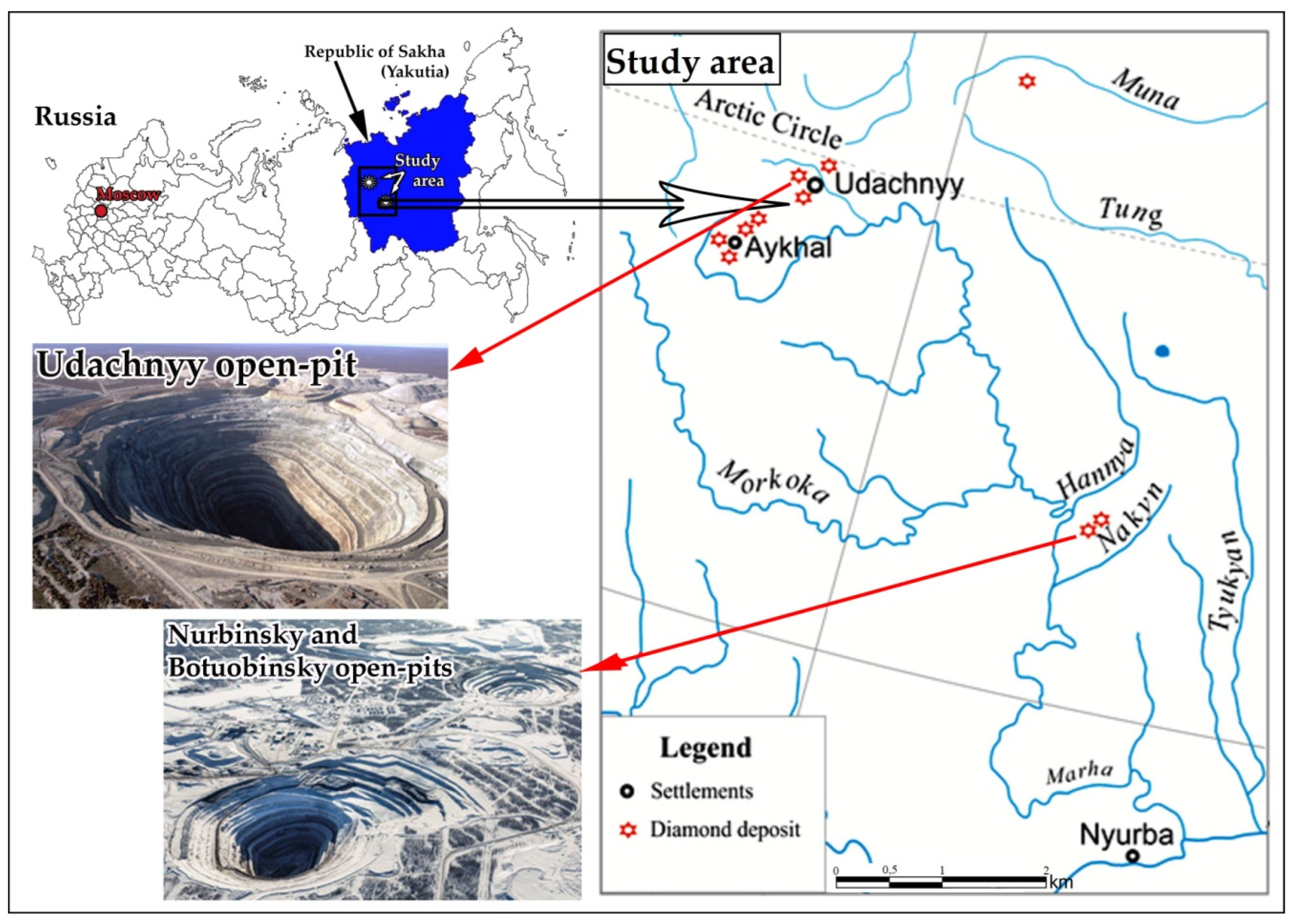
The studied area is located in Western Yakutia (Eastern Siberia of Russia). The Udachninsky and Aikhalsky (MPP) are located within the Daldyn-Alakit diamond-bearing area, and Nyurbinsky (MPP) in the Sredne-Markhinsky diamond-bearing area (
Figure 1).
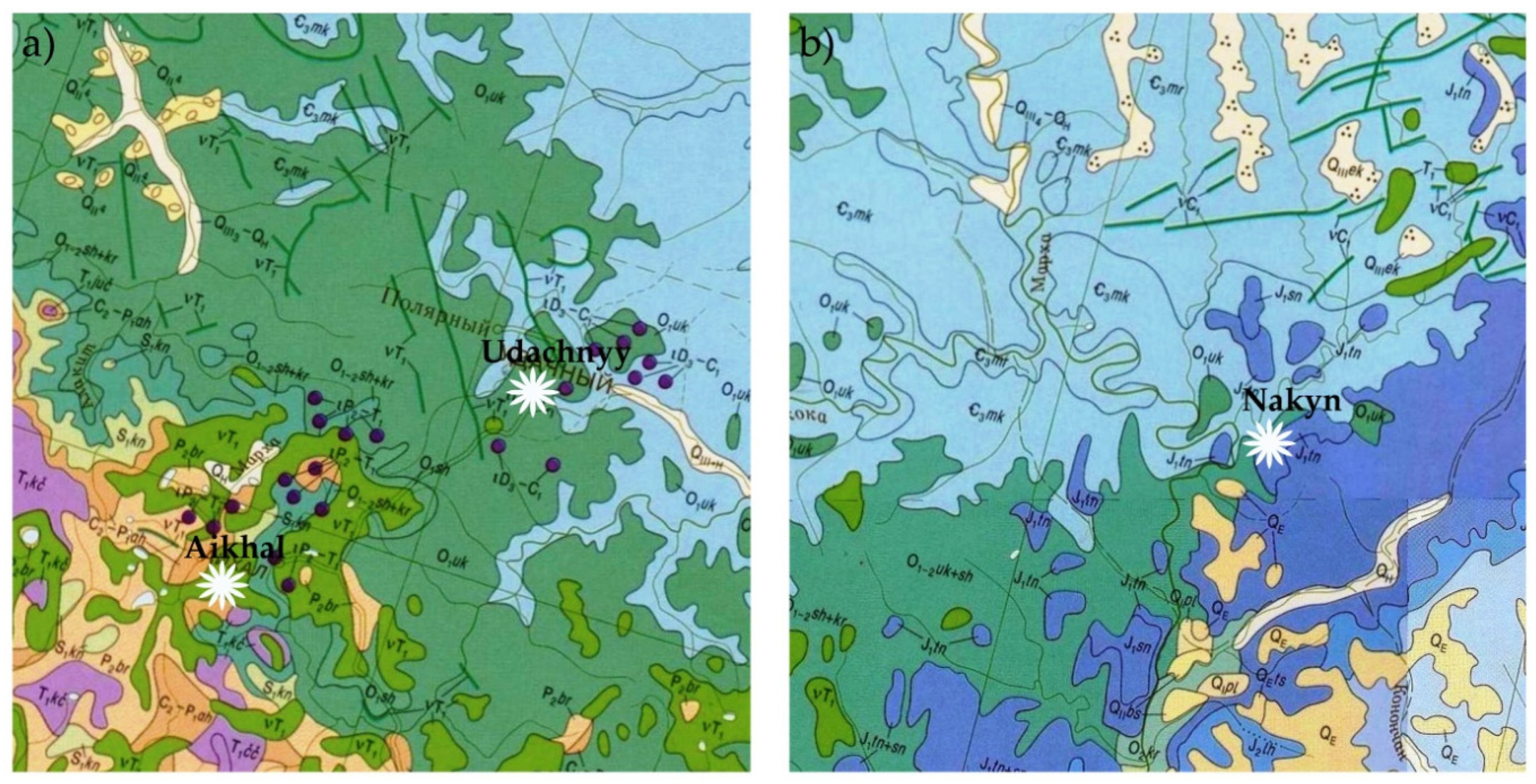
In regional tectonic terms, the territories are located in the junction zone of anticline and syncline of the Siberian platform complicated by a fault system, kimberlite and trap magmatism. The kimberlite fields are localized at the intersections of fracture zones with the aulacogens, which represent an ancient rift. In the geological structure, the Archean crystalline basement is covered with a sedimentary cover from 2.4–4 km in the area of the middle Markha. The sedimentary cover is made up of the Vend—lower Paleozoic, middle Paleozoic and Mesozoic layers of geology, represented by limestones, dolomites, and their clay and marly differences (
Figure 2).
The climate of the territory is sharply continental and belongs to the subarctic zone of the Siberian region in the north. Winter is severe and long with minimum temperatures below −50 °C and a short summer; the average annual air temperature in the area of Udachny is −11.8 °C. The entire basin of the Markha river is located in the zone of permafrost rock mass, the depth of its bottom varies in the study areas from 350 m (in the south) to 1050 m (in the north). The seasonal thawing layer varies from 0.2–3 m. The following occurrences of cryogenic processes and phenomena are observed on the territory: solifluction, thermokarst, frost heaving, frost cracking, thermal erosion, and frost weathering [
14]. In the areas of deposits, there are all types of underground water typical for the cryolithozone: supra-, intra-and subpermafrost water. The supra permafrost water is represented by the fresh waters of the seasonally thawed layer, waters of the underflow, and sub-lacustrine taliks (ice-free zones within permafrost region). The Upper Cambrian, Middle Cambrian, and Lower Cambrian aquifer systems are distinguished in the sedimentary cover. Underground waters are brines with mineralization from 350–410 g/L. The most difficult hydrogeological conditions are typical for the Udachnaya kimberlite pipe. The brines contain high concentrations of trace components: Br, Li, Rb, Cs, and Sr. The leading position is occupied by Sr, in which content varies from 438.1–894.2 mg/dm
3. The Li content varies from 67.4–165.9 mg/dm
3, and Rb, respectively, from 4.89–18.9 mg/dm
3. Cs concentrations in brines are not more than 0.01 mg/dm
3. Brines belong to mineral bromine water type. Brines are highly aggressive, due to their high mineralization, ion composition, and low pH values. According to the aggressive effect on metals, calcium chloride is at the first place. The miming of deep horizons of the diamond deposit is related to the arrival of a large number of aggressive and environmentally dangerous calcium chloride brines—thousands and the first millions of cubic meters that require their subsequent disposal back into the subsurface [
15].
The landscapes of the territories are represented by north taiga open subshrub-moss-lichen larch forests in the zone of continuous distribution of permafrost rocks. The soil cover is dominated by different subtypes of cryozems (O-CR-Cg), lithozems (AO-C), carbolitozems (H-(C)–MCA), and gleezems (AO–GC).
3. Experiments
3.1. Material Survey and Sampling
The original exclusive materials of the field geo-ecological surveys performed earlier at the previous stages of research (1994–2019) were used as sources of initial information. The project materials of the state environmental expertise of large engineering projects on the territory of the West Yakutian diamond-bearing province were also involved. A large amount of information provides a sufficient degree of representativeness and updating of the obtained results.
Sampling was carried out at the sites of mining and processing plants, where a network of observations was established with a sampling step of 2 × 2 km on a scale of 1:100,000 km. Sampling frequency in summer every 3–4 years from the near-surface layer to a depth of 0–20 cm. In parallel, soil sections were made in different biotopes with the horizon-oriented sampling for the entire depth of defrosting, to characterize the soil cover. In total, in 2004–2019, 63 soil sections were made on the territory of two diamond-bearing regions and 3120 soil and subsoil samples were taken.
3.2. Data Analysis and Processing
The pH, Organic Matter (Humus), Total Nitrogen (TN), and Physical Clay (PC) were determined using pH meter method (Mettler Toledo, SevenCompact Advanced), photoelectric colorimetric method (KFK-2 UHL 4.2), spectrophotometric method (PE-5300VI), and pipette method for particle size analysis (Kachinsky method), respectively.
Heavy metal contents was determined in mobile forms by atomic absorption spectrometry on multichannel gas analyzer (MGA-915 GC Lumex). For complex characterization of forms of heavy metals, 1 N HNO3 was used, which, in contrast to H2O and 1 N HCl, extracts acid-soluble elements that are more firmly bound with the soil. Total gross trace elements were determined using emission spectrum analysis at diffraction spectrograph DFS-8.
The ecological and geochemical characterization of soil pollution was carried out according to geochemical indicators, which take into account the distribution of both individual metals involved in the pollution and their associations due to the polyelement nature of the chemical composition of technogenic flows that form the pollution. The concentration factor (
Kc) of chemical elements and the total pollution indicator (
Zc) are these indicators. The calculation formulas are:
where
Ci is the actual content of the pollutant in the soil, mg/kg;
Cf is the background content of the pollutant in the soil, mg/kg;
where
Kc is the concentration factor of the
i-th component of pollution with values
Kc > 1.5;
n is the number of anomalous elements. Items with very low background content are not included in the count.
The gradations of the degree of soil cover contamination are:
Zc < 16—permissible; 16 to 32—moderately hazardous; 32 to 128—hazardous; and ≥128—extremely hazardous [
16].
The obtained quantitative data were processed using software Microsoft Excel 2016, OriginPro 8.5.1, ArcGIS 9.0. Correlation analysis was performed using Statistica 6.0.
4. Results
Significant excesses over the background concentrations of gross and mobile forms of trace-and macroelements in soils are observed throughout the territory in the zone of impact of quarry-dump complexes of the studied diamond-bearing areas. Their sources are local impact effects that differ in level and geochemical spectrum from regional inhomogeneities. In this sense, physical and chemical properties of soils are criteria for assessing the environmental and sanitary-toxicological state of soils. Variations of integral indicators for assessing the state of the soil cover (Kc and Zc) are criteria that characterize the degree of evolution of geochemical risks at a particular site. Analysis of geochemical risks allows you to determine the level of accumulated geoecological damage and assess the level of pollution. In turn, it also helps to develop recommendations for reducing environmental risks and plan activities aimed at eliminating the negative consequences of productive activities.
Table 1 shows an integrated assessment of the geochemical conditions of the Daldyn-Alakit and Sredne-Markhinsky diamond-bearing areas.
5. Discussion
The impact of geochemical factors on the near-surface parts of the lithosphere creates prerequisites for the formation of environmental risks within certain areas and territories [
17]. On the territory of the studied diamond-bearing areas, quarry-dump complexes have been formed, which include ground-based technogenic storage of mining products (waste rock dumps) and enrichment products (tailing dumps). The impact of quarry-dump complexes is manifested by the formation of areal technogenic geochemical anomalies in the soil cover. Therefore, directly on the territory of the industrial site, along with natural types of soils—cryosemes, soils that are in the immediate zone of impact of man-made objects are formed, with identified surface contamination, as well as man-made surface formations (MMSO) in the form of soil dumps and tailing dumps.
Geochemical risks for the Daldyn-Alakit diamond-bearing region appear as an accumulation of a wide range of trace elements, such as Cr, Co, Ni, Mn, Li, Be, and Sn on the day surface during mining operations. Biogenic accumulation of Ni, Mn, and Cd in the upper layer of the soil and Cr, Ni, Co, Mn, and Cu in the suprapermafrost soil horizon are typical for the soils of the studied area—cryozems.
Geochemical risks for the Daldyn-Alakit diamond-bearing region are the spatial variation of the trace element composition of soils, bottom sediments and water, which appear in increased concentrations of Cr, Ni, Co, Ti, Si, Y, Nb, Li, Be, and Sr. At the same time, Sr and Li are markers of the impact of highly mineralized groundwater.
Most of the trace elements are in an inert bound state, due to aerotechnogenic dispersion and accumulate in the upper organic-mineral horizons of soils. If the integrity of the soil profile is preserved, the accumulation only of trace elements occurs, which is a potential threat in the environmental aspect. Changes in soil and geochemical conditions (chemical pollution, water flood, water logging, development of salinization processes), mechanical violation of the integrity of the soil profile, etc. will lead to a gradual and possible mass transition of trace elements into mobile forms.
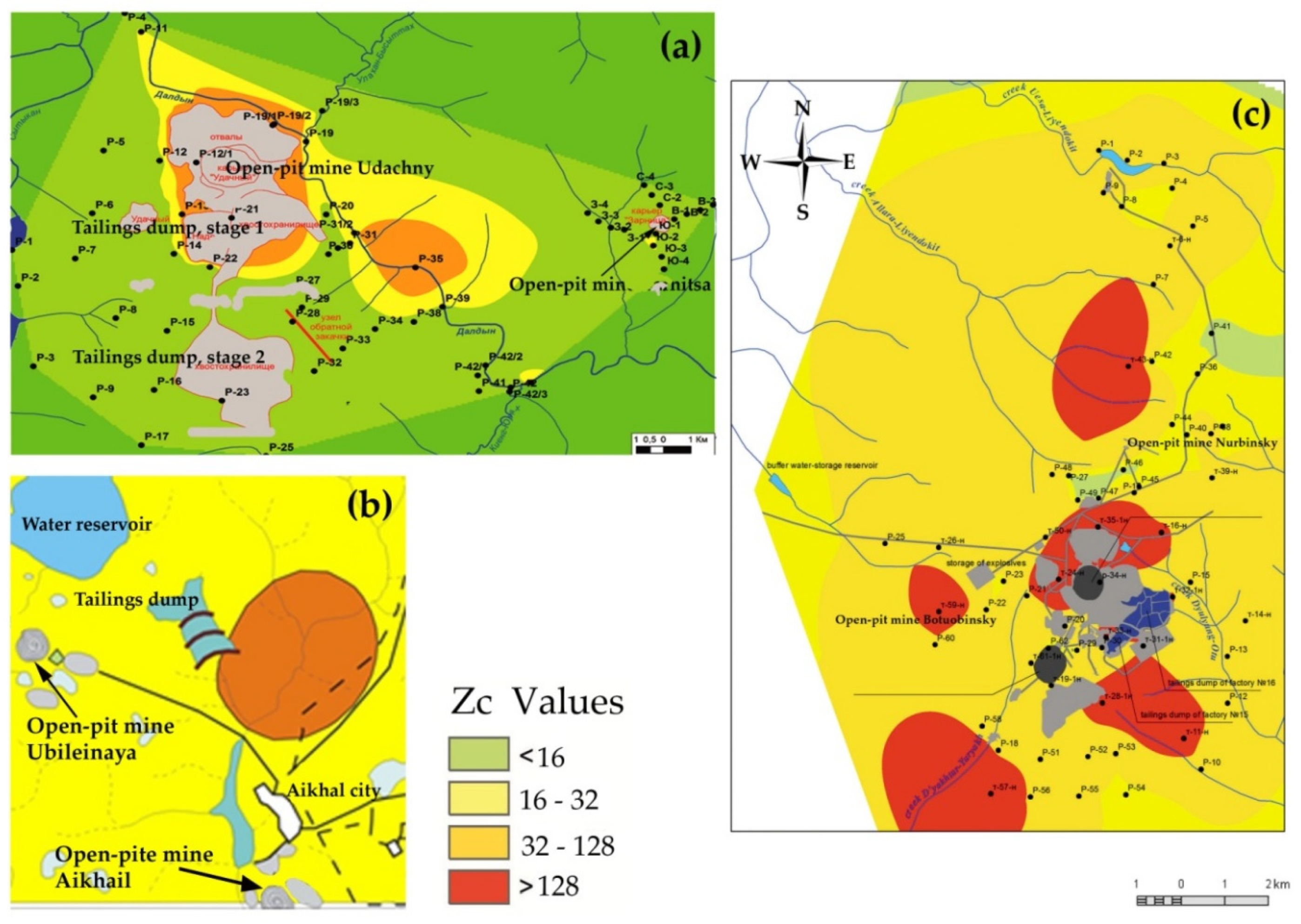
The ecological and geochemical situation of the territory of Udachninsky MPP is characterized mainly by an acceptable and moderately dangerous category of pollution, and Aikhalsky MPP and Nyurbinsky MPP by a moderately dangerous one (
Figure 3).
At the same time, local areas with a dangerous category of pollution are observed at industrial sites of the Daldyn-Alakit diamond-bearing region. The territory of the Sredne-Markhinsky diamond-bearing region is characterized by a higher level of pollution with the category—extremely dangerous. Thus, these studies allowed us to identify and localize areas of technogenic anomalies that characterize the active accumulation of gross and mobile forms of trace elements.
6. Conclusions
The combination of mining-geological and physical-geographical conditions with various aspects of the development of diamond resources determines the spectrum and nature of the distribution of chemicals in the natural environment and their danger to ecosystems. When the soil and vegetation layer is disturbed, gravitational movement of soil and subsoil material along the slopes occurs with cryogenic solifluctional spreading of clay masses, mixing of their composition, and activation of geochemical processes. Rocks on the surface are subject to cryogenic weathering. In addition, violation of the soil cover or its destruction are a catalyst for geochemical processes of migration of matter, and within the boundaries of anthropogenic landscapes they cause the formation of technogenic geochemical anomalies. Within the latter, the processes of water migration are most intensively expressed, leading to the accumulation or dispersion of the most mobile trace elements, removal of biogenic elements, salinization, leaching of soils, and a sharp violation of the natural balance. The presence of geochemical risk objects on the territory of the studied diamond mining areas led to an average threefold increase in the area of the sites characterized by an extremely dangerous category of soil contamination compared to the state of 2014.
On the territory of the Sredne-Markhinsky diamond-bearing region, the area of highly dangerous pollution increased by 120 km2; three areal and two-point high-contrast anomalies were recorded with an extremely dangerous level of soil contamination, with a total conditional area of about 51.6 km2. The increasing trend has a north-west and south-east direction. On the territory of the Daldyn–Alakit diamond-bearing region, a dangerous ecological situation is recorded on 75% of the entire area.
Changes in the chemical composition of soils and waters, in turn, are reflected in the biogeochemical parameters of the ecosystems of the region as a whole, increasing the concentration of chemical elements, primarily in edificator plants.
Studies of ecological-geochemical state of Daldyno-Alakit and Sredne-Markhinsky diamond-bearing areas allowed us to localize the area of soil pollution of the Udachninskiy, Aihalsky, and Nyurbinsky mining and processing plants that represent a potential threat to the ecosystem as a whole.


