1. Introduction
Before a devastating earthquake, the seismic performance of existing buildings in urban areas needs to be assessed and the vulnerable ones must be determined in order to prevent fatalities, injuries and property losses. In this regard, it is very important to extract necessary building inventory information that will provide a critical tool for the decision-makers. Data collection for such a building inventory database can be time-consuming and costly on an urban scale with conventional methods such as in situ investigations. Approaches that are able to speed up these processes and reduce the costs are required. Determining at least some of the data required to determine the seismic performance of an existing building using alternative methods instead of conventional methods will provide a significant advantage. The fundamental building period is among of the most important data that are required for assessing the seismic vulnerability of a building. The earthquake force is a function of the fundamental vibration period of the building [
1,
2]. If the building height is known, the fundamental vibration period of the building can be estimated easily using empirical equations. According to recent studies conducted in Eskisehir building stock [
3,
4], two different empirical equations should be used for the buildings constructed before and after 2016. For this reason, the year 2016 was chosen as a threshold for the building construction period in the study.
Remote sensing data and techniques have been successfully used for building information extraction [
5] and post-earthquake evaluation of collapsed buildings [
6]. In addition, high-resolution imagery from unmanned aerial vehicles (UAV) in combination with elevation models [
7] for extracting building inventory information. Remote sensing data have also been used for seismic risk assessment [
8,
9]. However, the period of construction of the buildings has been estimated based on assumptions from land cover classifications over medium spatial resolution imagery.
In this study, the potential of PlanetScope satellite imagery for extracting building inventory information was investigated. The main objectives of the study are (i) to extract buildings using deep learning method, (ii) to determine the height of the buildings using shadow length information and (iii) to determine the construction period of the buildings as before or after 2016. For this purpose, two acquired 3 m PlanetScope satellite images (2016 and 2020) were used over the study area located in Eskisehir, Turkey, was processed and analyzed.
2. Material and Methods
2.1. Study Area and Data
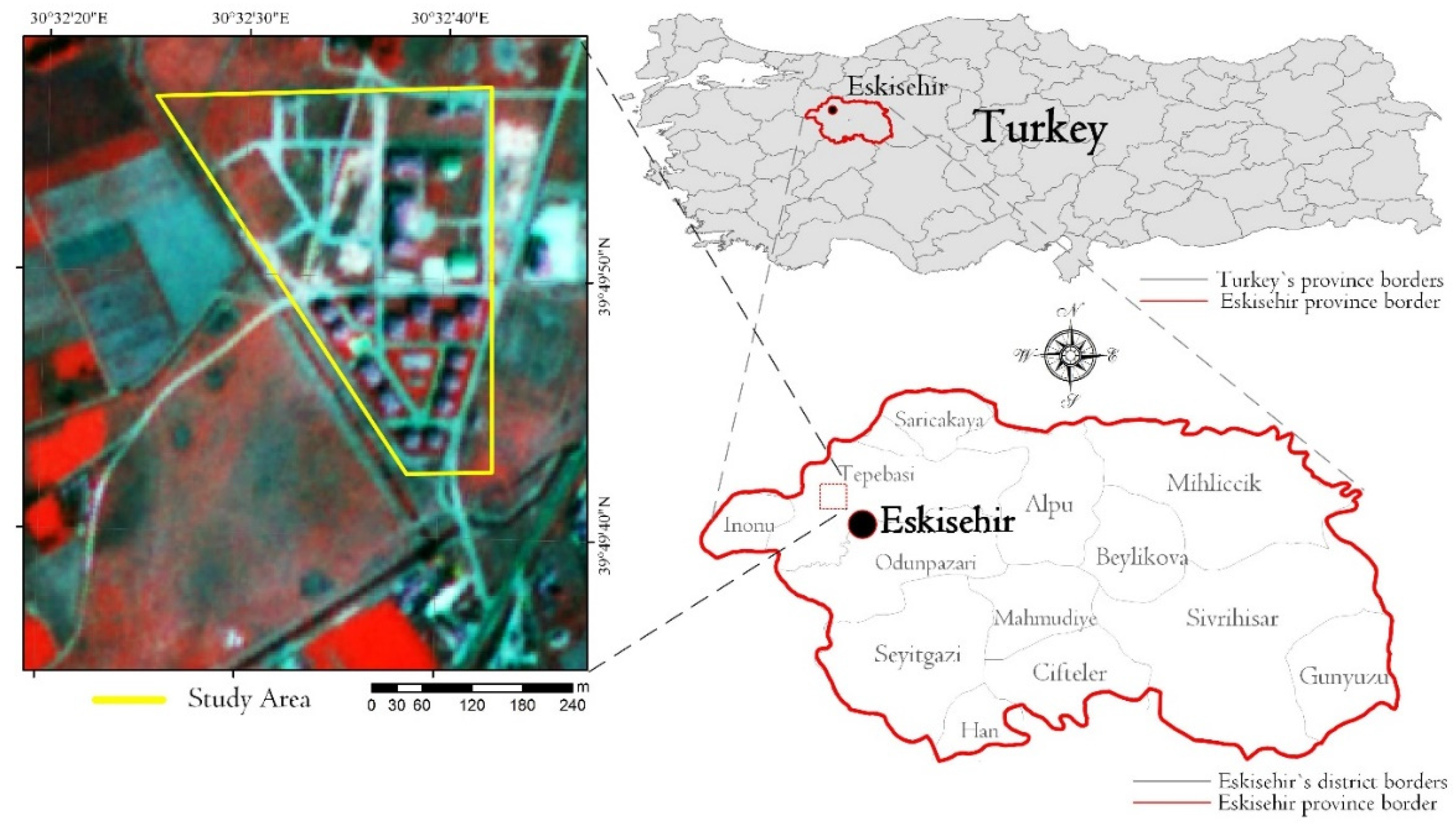
Eskisehir is a city in northwestern Turkey and the capital of the Eskisehir Province. The city is located on the banks of the Porsuk River. The population of Eskisehir is approximately 850,000 inhabitants. The study has been conducted over two separate residential building complexes, one built from 2010 to 2012 and one from 2018 to 2020 (
Figure 1). In addition, a block of high school buildings has been taken into consideration. There are 37 buildings in the study area, all of the buildings are mid-rise, reinforced-concrete, moment-resisting frame buildings. Infill walls of the buildings are made of hollow clay bricks and are plastered with gypsum.
With more than 150 satellites in orbit launched in 2015 and 2017, PlanetScope satellite imagery offers 3 m three and four-band images daily [
10]. In addition, it offers new opportunities for researchers to enhance remote sensing applications. In the last few years, the combination of PlanetScope and other satellite imageries have been investigated for vegetation detection and monitoring [
11] and generating red-edge images [
12,
13]. However, the effectiveness of PlanetScope data for extracting building inventory information is yet to be assessed. For that purpose, two PlanetScope images from 2016 and 2020 were used over the study area.
2.2. Methodology
The convolution neural network (CNN) workflow using Trimble’s eCognition Developer 9.3 was applied for detecting the buildings in the study area, which is based on the Google TensorFlow [
14]. The application of the CNN in eCognition consisted of three steps: (i) derivation of training samples, (ii) training the CNN model and (iii) applying the trained CNN model. For the training 10 × 10 pixel samples were collected using the near-infrared band of the PlanetScope data, where the sample correlation was over 0.85 for both images.
Common evaluation statistics for binary classification were calculated. True positives (TP) (a building is correctly identified), false positives (FP) (a building is incorrectly identified; a commission error) and false negatives (FN) (a building is missed; an omission error). TP, FN and FP indicate perfect identification, under-identification and over-identification, respectively. Then, the precision (P), recall (R) and F-score (F) were calculated. Precision (i.e., positive predictive value) describes the correctness of detected buildings and how well the algorithm dealt with false positives (Equation (1)), recall (i.e., sensitivity) describes the building detection rate and how well the algorithm dealt with false negatives (Equation (2)) and the F-score is the harmonic mean of recall and precision and reports the overall accuracy considering both commission and omission errors (Equation (3)) [
14].
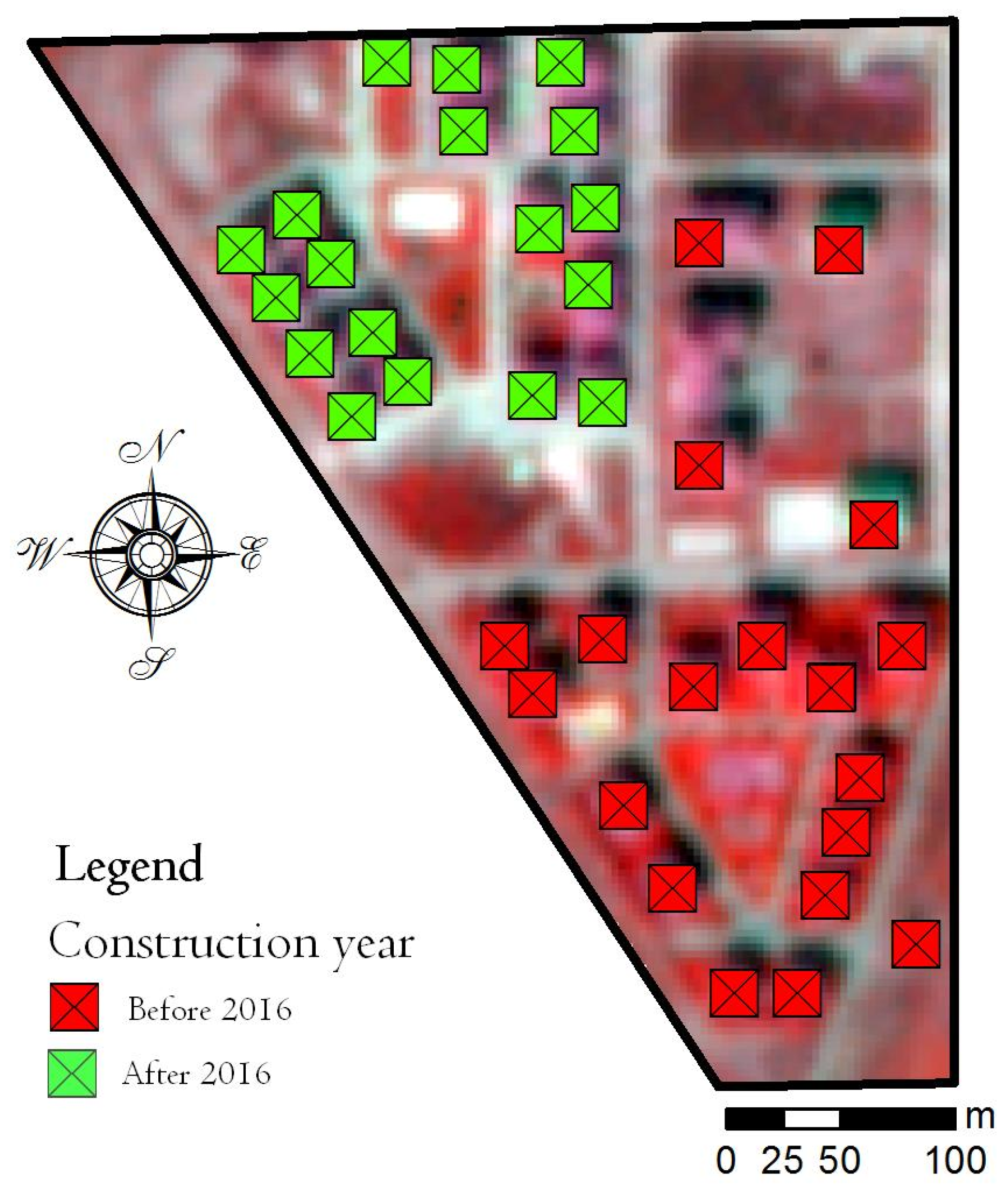
As this study aimed to determine the construction period, or whether the buildings were constructed before or after 2016, a comparison between the two classified images was made and the buildings that were classified twice were assumed to be constructed before 2016, while once classified buildings were assumed to be constructed after 2016.
For the building heights, the length of the shadow of the buildings has been measured and then using the sun elevation angle of the time of the passing of the satellite over the study area has been used. For better measuring of the length of the buildings, the pixel size was resampled to 1 m using the cubic convolution resampling method, which lead to smoothing the edges of the buildings and the shadows. The estimated heights of the buildings were calculated using Equation (4).
As an accuracy assessment, the obtained height values with the applied method in this study were compared with terrestrial survey results. Thus, 35 out of 37 building heights were extracted and these building heights were measured with laser distance meter at the field [
7].
3. Results and Discussion
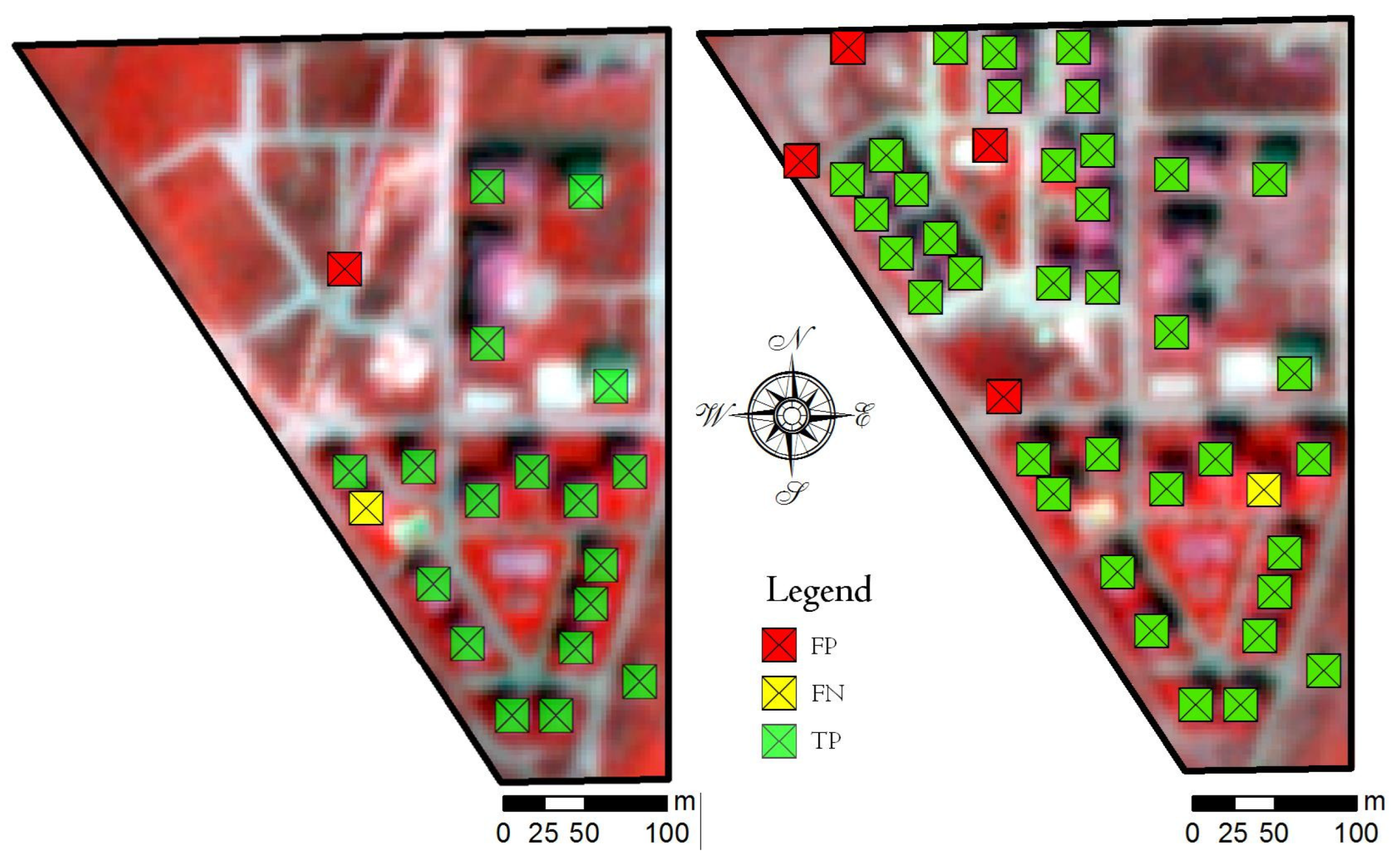
The classification results are presented in
Figure 2. The applied methodology accurately detected the buildings in the study area and effectively dealt with small buildings that were barely visible on the satellite imagery. As can be seen from
Figure 2, in the image of 2016, one FP and one FN were detected, while 18 buildings were accurately classified. Similar was the case for the image from 2020, where, in addition to the one FN, three FPs were detected and 36 buildings were accurately classified. In addition, a visual inspection of the FP objects was made and it was concluded that the misclassification occurred over road edges and rectangular pools.
The evaluation statistics for the classification showed high accuracy parameters. The accuracy assessment analyses are shown in
Table 1.
Afterward, the construction year was determined. Since in this paper we aim at determining whether the building was constructed before or after 2016, we used two satellite images, one from 2016 and one from 2020. In
Figure 3, the results of the construction year analyses are presented. It was determined that 19 buildings were constructed before 2016, while 18 buildings were constructed after 2016. With the visual inspection of the images, it was concluded that the construction period was accurately determined for all of the buildings in the study area.
For two of the buildings in the study area, the length of the shadows could not be measured due to the spatial resolution of the images. Thus, the height of 35 buildings was measured on the field. According to the results, the smallest difference between the measured and estimated values was 1%, while the biggest difference was approximately 5%. This error rate is satisfactory for using the building heights to predict the fundamental vibration periods of the buildings using empirical equations.
It should be noted that, for two buildings under 3 m height, the shadow length could not be determined; thus, the height of the building could not be calculated. In addition, the minimum distance between two buildings was four meters.
4. Conclusions
The study investigates the ability of PlanetScope data for building information extraction. Namely, in this study, the buildings, their construction period and height were determined with high accuracy. For the building extraction, we used the CNN model, with an accuracy of over 93.5%. The heights of the buildings were calculated using the lengths of the shadow and the sun elevation angle with an error of 1–5%. With the visual inspection of high spatial resolution imagery from Google Earth, it was concluded that the construction period was accurately determined.
The results of the study showed that PlanetScope data can be successfully used for building information extraction in study areas with similar conditions, detached buildings at least four meters apart from each other and for buildings higher than 3 m.
According to the results, the crucial information about existing buildings like building construction periods and building heights can be determined by using remote sensing techniques without sending teams of engineers to the field. The in situ teams need to collect more information from buildings to assess the seismic performance of buildings; then, at least the workload of engineers can be reduced by gathering that information with the help of remote sensing techniques.
Author Contributions
G.K. and O.K. conceived and designed the experiments; G.K. performed the remote sensing experiments; G.K. and O.K. analyzed the data; G.K. and O.K. wrote the paper. All authors have read and agreed to the published version of the manuscript.
Institutional Review Board Statement
Not applicable.
Informed Consent Statement
Not applicable.
Acknowledgments
This study was supported by Eskisehir Technical University Scientific Research Projects Commission under the grant no: 20ADP112, Project: “Building Inventory Information for Seismic Damage Vulnerability Assessment Using Remote Sensing Techniques”. The author wants to thank Planet Labs, Inc. for providing the high-resolution Planet Scope imagery.
Conflicts of Interest
The authors declare no conflict of interest.
Abbreviations
The following abbreviations are used in this manuscript:
| UAV | Unmanned Aerial Vehicle |
| CNN | Convolution Neural Network |
| EO | Earth Observation |
| FN | False Negative |
| FP | False Positive |
| TP | True Positive |
References
- Hong, L.-L.; Hwang, W.-L. Empirical formula for fundamental vibration periods of reinforced concrete buildings in taiwan. Earthq. Eng. Struct. Dyn. 2000, 29, 327–337. [Google Scholar] [CrossRef]
- Pan, T.-C.; Goh, K.S.; Megawati, K. Empirical relationships between natural vibration period and height of buildings in Singapore. Earthq. Eng. Struct. Dyn. 2013, 43, 449–465. [Google Scholar] [CrossRef]
- Tsuno, S.; Yamanaka, H.; Kaplan, O.; Arslan, M.S.; Ozel, O. Characteristics of building vibrations estimated in various site conditions in Eskisehir, Turkey. In Proceedings of the the 13th SEGJ International Symposium, Tokyo, Japan, 12–14 November 2018; Society of Exploration Geophysicists: Tulsa, OK, USA, 2019; pp. 514–517. [Google Scholar]
- Kaplan, O. Proposal of an Empirical Equation by Means of Ambient Vibration Measurements for Fundamental Vibration Periods of Mid-Rise rc Buildings. Ph.D. Thesis, Anadolu University, Eskisehir, Turkey, 2018. (In Turkish). [Google Scholar]
- Erdem, F.; Avdan, U. Comparison of Different U-Net Models for Building Extraction from High-Resolution Aerial Imagery. Int. J. Environ. Geoinform. 2020, 7, 221–227. [Google Scholar] [CrossRef]
- Çömert, R.; Matcı, D.K.; Avdan, U. Detection of collapsed building from unmanned aerial vehicle data with object based image classification. Anadolu Üniversitesi Bilim Ve Teknol. Derg. B Teor. Bilimler 2018, 6, 109–116. [Google Scholar] [CrossRef]
- Comert, R.; Kaplan, O. Object Based Building Extraction And Building Period Estimation From Unmanned Aerial Vehicle Data. Isprs Ann. Photogramm. Remote. Sens. Spat. Inf. Sci. 2018, 4, 71–76. [Google Scholar] [CrossRef]
- Wieland, M.; Pittore, M.; Parolai, S.; Zschau, J. Exposure Estimation from Multi-Resolution Optical Satellite Imagery for Seismic Risk Assessment. Isprs Int. J. Geo-Inf. 2012, 1, 69–88. [Google Scholar] [CrossRef]
- Liuzzi, M.; Pelizari, P.A.; Geiß, C.; Masi, A.; Tramutoli, V.; Taubenböck, H. A transferable remote sensing approach to classify building structural types for seismic risk analyses: The case of val d’agri area (italy). Bull. Earthq. Eng. 2019, 17, 4825–4853. [Google Scholar] [CrossRef]
- Team, P. Planet application program interface: In space for life on Earth. San Fr. CA 2017, 2017, 40. [Google Scholar]
- Gašparović, M.; Medak, D.; Pilaš, I.; Jurjević, L.; Balenović, I. Fusion of sentinel-2 and planetscope imagery for vegetation detection and monitorin. In Proceedings of the ISPRS TC I Mid-term Symposium Innovative Sensing-From Sensors to Methods and Applications, Karlsruhe, Germany, 10–12 October 2018. [Google Scholar]
- Li, W.; Jiang, J.; Guo, T.; Zhou, M.; Tang, Y.; Wang, Y.; Zhang, Y.; Cheng, T.; Zhu, Y.; Cao, W.; et al. Generating Red-Edge Images at 3 M Spatial Resolution by Fusing Sentinel-2 and Planet Satellite Products. Remote. Sens. 2019, 11, 1422. [Google Scholar] [CrossRef]
- Siok, K.; Ewiak, I.; Jenerowicz, A. The simulation of new spectral bands for the purpose of data pansharpening. Fifth Recent Adv. Quant. Remote Sens. 2018, 430. [Google Scholar] [CrossRef]
- Csillik, O.; Cherbini, J.; Johnson, R.; Lyons, A.; Kelly, M. Identification of Citrus Trees from Unmanned Aerial Vehicle Imagery Using Convolutional Neural Networks. Drones 2018, 2, 39. [Google Scholar] [CrossRef]
| Publisher’s Note: MDPI stays neutral with regard to jurisdictional claims in published maps and institutional affiliations. |
© 2020 by the authors. Licensee MDPI, Basel, Switzerland. This article is an open access article distributed under the terms and conditions of the Creative Commons Attribution (CC BY) license (https://creativecommons.org/licenses/by/4.0/).


