GEOSAT 2 Atmospherically Corrected Images: Algorithm Validation †
Abstract
:1. Introduction
2. Model Description
3. Model Validation
- First, the root mean square error (RMSEbi) has been found, band by band, between the values of the product DE2 and S2.
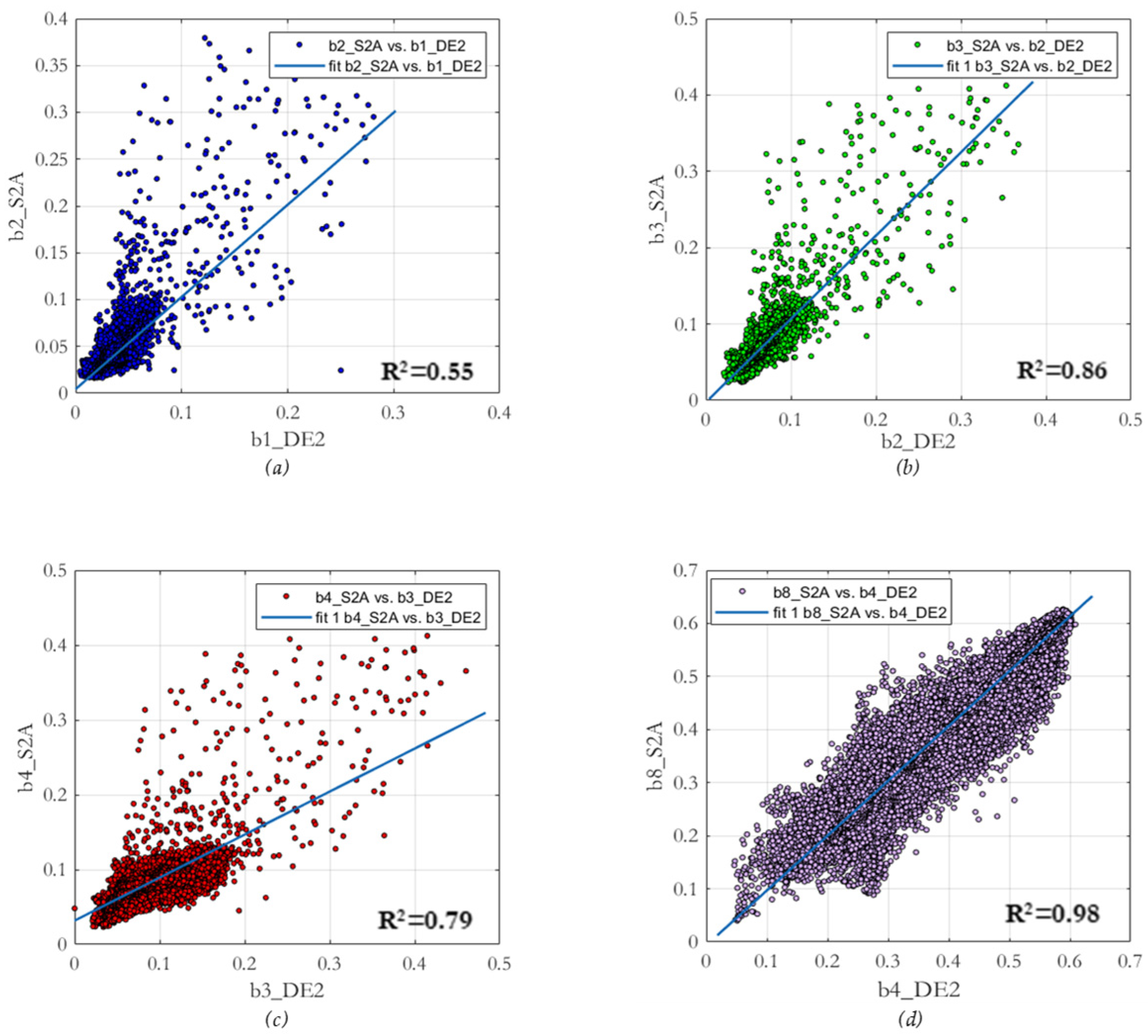
- The second procedure relied on a regression analysis between the corresponding bands of both products, fitting a linear function to the two datasets. In this analysis, the regression coefficient (R2) and the fitting error (RMSE) are obtained, where the latter can be interpreted as a deviation from the fitted function.
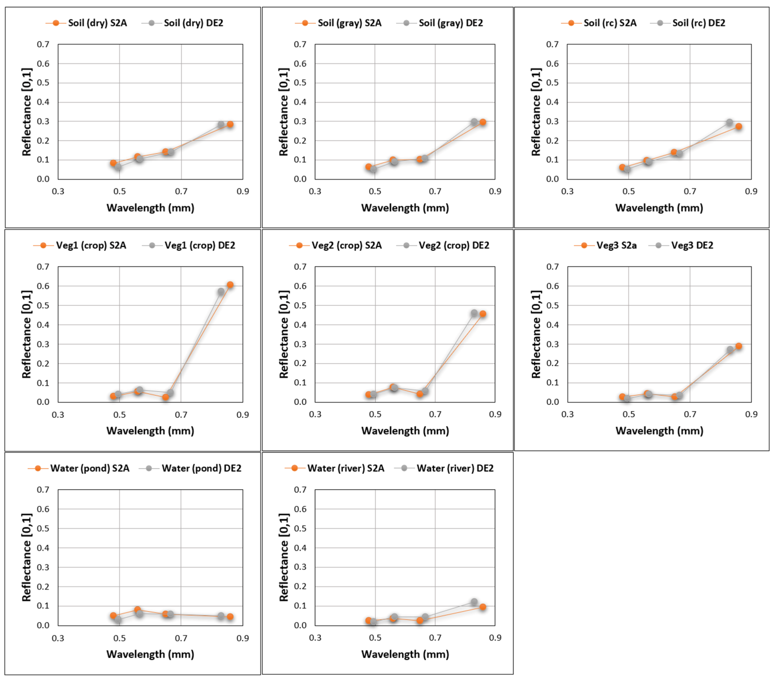
- Thirdly, for generic land cover types such as vegetation, soil, and water, spectral profiles are acquired at specific positions within the study area, and these profiles are depicted graphically.
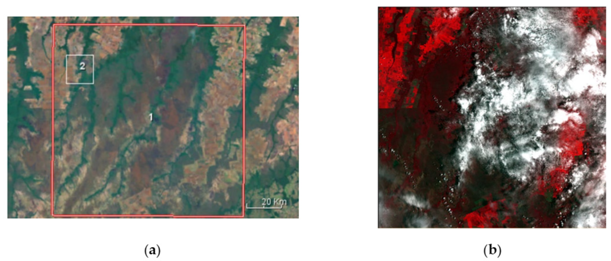
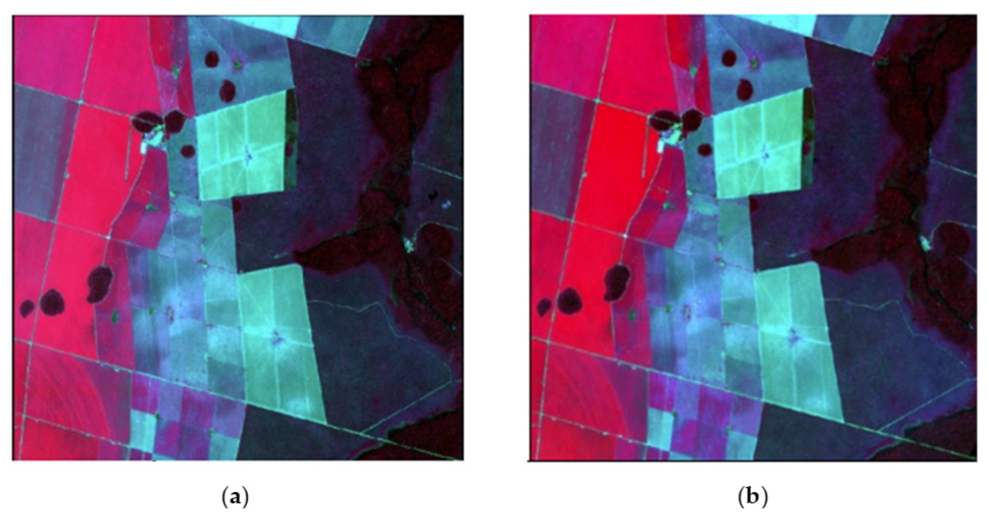
Overall Validation: Brazil
4. Results
5. Conclusions
Author Contributions
Funding
Institutional Review Board Statement
Informed Consent Statement
Data Availability Statement
Acknowledgments
Conflicts of Interest
References
- Berk, A.; Conforti, P.; Kennett, R.; Perkins, T.; Hawes, F.; van den Bosch, J. MODTRAN6: A major upgrade of the MODTRAN radiative transfer code. In Proceedings of the SPIE 9088, Algorithms and Technologies for Multispectral, Hyperspectral, and Ultraspectral Imagery XX, 90880H, SPIE Defense + Security, Baltimore, MD, USA, 13 June 2014. [Google Scholar] [CrossRef]
- Vermote, E.F.; Tanré, D.; Deuze, J.L.; Herman, M.; Morcette, J.J. Second Simulation of the Satellite Signal in the Solar Spectrum, 6S: An Overview. IEEE Trans. Geosci. Remote Sens. 1997, 35, 675–686. [Google Scholar] [CrossRef]
- Kotchenova, S.Y.; Vermote, E.F.; Matarrese, R.; Klemm, F.J., Jr. Validation of a vector version of the 6S radiative transfer code for atmospheric correction of satellite data. Part I: Path radiance. Appl. Opt. 2006, 45, 6762–6774. [Google Scholar] [CrossRef] [PubMed]
- Second Simulation of a Satellite Signal in the Solar Spectrum–Vector (6SV) User Guide. Available online: https://salsa.umd.edu/files/6S/6S_Manual_Part_1.pdf (accessed on 31 July 2023).
- Atmospheric Corrections with FLAASH. Available online: https://www.l3harrisgeospatial.com/docs/FLAASH.html (accessed on 31 July 2023).
- M2T1NXAER, Global Modeling and Assimilation Office (GMAO) (2015), MERRA-2 tavg1_2d_aer_Nx: 2d,1-Hourly, Time-Averaged, Single-Level, Assimilation, Aerosol Diagnostics V5.12.4, Greenbelt, MD, USA, Goddard Earth Sciences Data and Information Services Center (GES DISC). Available online: https://doi.org/10.5067/KLICLTZ8EM9D (accessed on 31 July 2023).
- M2TMNXAER, Global Modeling and Assimilation Office (GMAO) (2015), MERRA-2 tavgM_2d_aer_Nx: 2d, Monthly Mean, Time-Averaged, Single-Level, Assimilation, Aerosol Diagnostics V5.12.4, Greenbelt, MD, USA, Goddard Earth Sciences Data and Information Services Center (GES DISC). Available online: https://doi.org/10.5067/FH9A0MLJPC7N (accessed on 31 July 2023).
- STRM 1 Arc-Second Global (30 m) Elevation Data. Available online: https://www.usgs.gov/centers/eros/science/usgs-eros-archive-digital-elevation-shuttle-radar-topography-mission-srtm-1 (accessed on 31 July 2023).


| Number of DE2 Band | DE2λ_central, [λ] (µm) | Number of S2 Band | S2λ_central, [λ] (µm) |
|---|---|---|---|
| 1 (blue) | 0.496 − [0.466; 0.525] | B2 (blue) | 0.490 − [0.458; 0.523] |
| 2 (green) | 0.566 − [0.532; 0.599] | B3 (green) | 0.560 − [0.543; 0.578] |
| 3 (red) | 0.667 − [0.640; 0.697] | B4 (red) | 0.665 − [0.650; 0.680] |
| 4 (NIR) | 0.831 − [0.770; 0.892] | B8 (NIR) | 0.842 − [0.785; 0.900] |
| Product Id | Acquisition Date |
|---|---|
| DE2_MS4_L1C_000000_20211125T144952_20211125T144954_DE2_40296_88C0 | 20211125, 14:49:54 |
| S2A_MSIL2A_20211125T141051_N0301_R110_T21LUE_20211125T164741 | 20211125, 14:10:51 |
| DE2 Bands | S2B Bands | RMSEbi |
|---|---|---|
| B1 | B2 | 0.0106 |
| B2 | B3 | 0.0086 |
| B3 | B4 | 0.0151 |
| B4 | B8 | 0.0325 |
| DE2 Bands | S2B Bands | R2 | RMSEaj |
|---|---|---|---|
| B1 | B2 | 0.55 | 0.0096 |
| B2 | B3 | 0.86 | 0.0154 |
| B3 | B4 | 0.79 | 0.0079 |
| B4 | B8 | 0.98 | 0.0179 |
| DE2/S2A | DE2 | S2A | DE2 | S2A | DE2 | S2A | DE2 | S2A |
|---|---|---|---|---|---|---|---|---|
| Soil: Dry (313459, 8479785) | Soil: Gray (313459, 8479785) | Soil: Road Crossing (313459, 8479785) | Veg 1 (Crop) (313459, 8479785) | |||||
| B1/2 | 0.062 | 0.083 | 0.052 | 0.062 | 0.052 | 0.060 | 0.042 | 0.029 |
| B2/3 | 0.104 | 0.117 | 0.090 | 0.100 | 0.092 | 0.097 | 0.064 | 0.056 |
| B3/4 | 0.140 | 0.141 | 0.109 | 0.103 | 0.134 | 0.138 | 0.049 | 0.024 |
| B4/8 | 0.285 | 0.283 | 0.299 | 0.294 | 0.295 | 0.272 | 0.572 | 0.606 |
| DE2/S2A | Veg 2 (crop) (313459, 8479785) | Veg 3 (forest) (313459, 8479785) | Water (pond) (313459, 8479785) | Water (river) (313459, 8479785) | ||||
| B1/2 | 0.041 | 0.037 | 0.020 | 0.027 | 0.029 | 0.048 | 0.017 | 0.024 |
| B2/3 | 0.073 | 0.077 | 0.042 | 0.043 | 0.059 | 0.080 | 0.043 | 0.036 |
| B3/4 | 0.057 | 0.040 | 0.036 | 0.057 | 0.059 | 0.058 | 0.043 | 0.024 |
| B4/8 | 0.462 | 0.456 | 0.272 | 0.462 | 0.049 | 0.043 | 0.122 | 0.092 |
Disclaimer/Publisher’s Note: The statements, opinions and data contained in all publications are solely those of the individual author(s) and contributor(s) and not of MDPI and/or the editor(s). MDPI and/or the editor(s) disclaim responsibility for any injury to people or property resulting from any ideas, methods, instructions or products referred to in the content. |
© 2023 by the authors. Licensee MDPI, Basel, Switzerland. This article is an open access article distributed under the terms and conditions of the Creative Commons Attribution (CC BY) license (https://creativecommons.org/licenses/by/4.0/).
Share and Cite
Fernández, C.; de Castro, C.; Calleja, M.E.; Sousa, R.; Niño, R.; García, L.; Fraile, S.; Molina, I. GEOSAT 2 Atmospherically Corrected Images: Algorithm Validation. Environ. Sci. Proc. 2024, 29, 64. https://doi.org/10.3390/ECRS2023-16296
Fernández C, de Castro C, Calleja ME, Sousa R, Niño R, García L, Fraile S, Molina I. GEOSAT 2 Atmospherically Corrected Images: Algorithm Validation. Environmental Sciences Proceedings. 2024; 29(1):64. https://doi.org/10.3390/ECRS2023-16296
Chicago/Turabian StyleFernández, César, Carolina de Castro, María Elena Calleja, Rafael Sousa, Rubén Niño, Lucía García, Silvia Fraile, and Iñigo Molina. 2024. "GEOSAT 2 Atmospherically Corrected Images: Algorithm Validation" Environmental Sciences Proceedings 29, no. 1: 64. https://doi.org/10.3390/ECRS2023-16296
APA StyleFernández, C., de Castro, C., Calleja, M. E., Sousa, R., Niño, R., García, L., Fraile, S., & Molina, I. (2024). GEOSAT 2 Atmospherically Corrected Images: Algorithm Validation. Environmental Sciences Proceedings, 29(1), 64. https://doi.org/10.3390/ECRS2023-16296


