1. Introduction
Future projections indicate an increase in energy consumption by 14% in OECD countries and by 84% in non-OECD countries by 2035 [
1], while 5-fold growth is expected for Türkiye by 2050 compared to the early 2000s [
2]. Currently, 51.8% of fossil fuel-based energy generation is sourced from natural gas and 48.2% from coal in the country, of which 60.2% of the latter is lignite coal [
3,
4].
Lignite coal is obtained by either underground or surface mining. Surface mining is a more economical method, requiring the removal of the vegetation and soil on the surface to extract the coal on the bedrock that is close to the land surface [
5,
6]. Such interventions, as well as the necessity to reserve large spaces for the expansion of the excavated areas and storage of excavation wastes, inevitably cause intense environmental damages such as disruption of the soil cover, land cover/land use, and habitats, an increased risk of soil erosion and floods, air and water pollution, and loss in agricultural productivity [
7,
8]. Amongst these, the impact of open pit mining areas on vegetation is critical and commonly researched in the literature using remote sensing (RS) and geographical information systems (GIS) capabilities and analyses. For example, NDVI is one of the most preferred techniques when focusing on the detection of vegetation [
9,
10,
11]. PCT, maximum likelihood monitoring [
9], simple ratio analysis [
12], TVDI [
13], and supervised classification [
14] are also preferred for the determination of the impacts on vegetation.
Surface-mined lignite mines in Türkiye, such as in the Milas–Ören mining region, have been controversial due to the massive loss of forested areas, which has severe consequences for local communities and ecosystems nationally and globally. In this context, this study aims to examine the spatio-temporal changes in the Milas–Ören mining area between 1984 and 2023 and thus reveal the destruction of vegetation due to mining activities. In this regard, change detection analyses with 5-year intervals were performed using Landsat images with Google Earth Engine (GEE), and conversions from vegetated areas (forests and olive groves) to mining areas and bare lands were detected. The results contribute to assessing the current situation in the Milas–Ören mining district and developing strategies for conserving forests and biodiversity by promoting sustainable mining practices.
2. Materials and Methods
2.1. Study Area
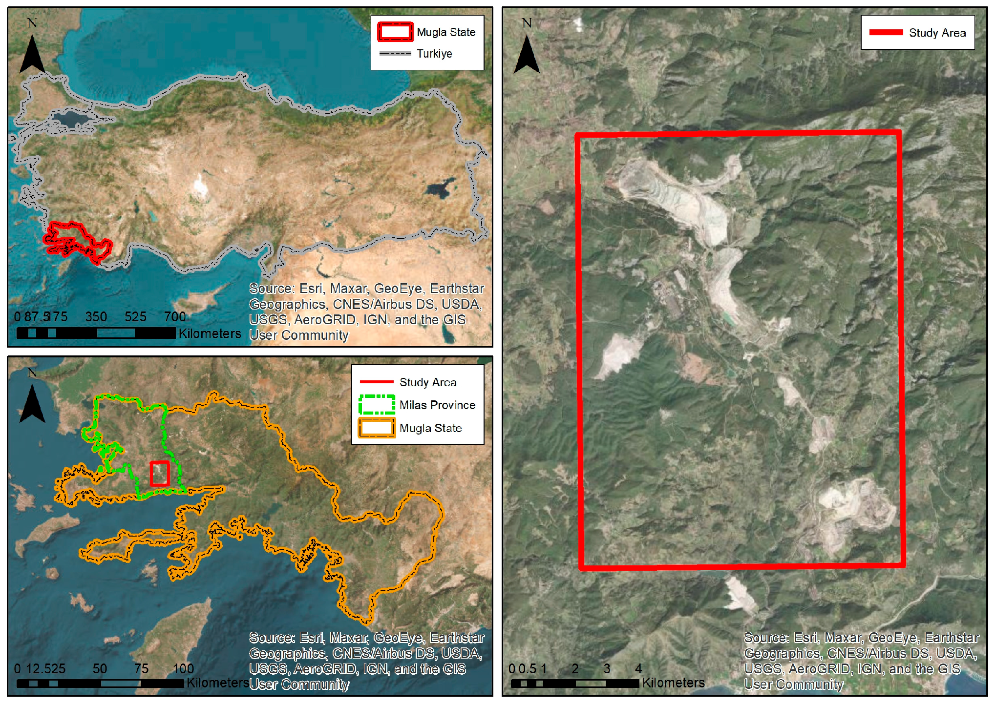
The study area, covering 13,809.88 ha and located at coordinates 37.12 north and 27.9 east, comprises the open lignite quarries around Milas–Ören road in Muğla, Türkiye (
Figure 1). A Mediterranean climate dominates the region, and the vegetation mainly consists of pine forests, maquis, and olive groves [
15,
16].
The lignite quarries in the area, dating back to 1979, were commissioned by the state for the thermal power plants in Yeniköy, Kemerköy, and Yatağan. The Milas–Ören mines were privatized in 2014, and 23,000 ha were granted a lignite mining license. Unused licensed areas cover 11,200 ha, including forests, agriculture, pastures, and residential areas [
15]. The study area is an important example of the massive environmental damage caused by open pit mining, as it is one of the largest lignite deposits in Türkiye.
2.2. Materials
The Milas–Ören lignite quarries and their adjacent environments were systematically analyzed using satellite images at 5-year intervals from 1984 to 2023. Images from the 1984–2009 period were sourced from Landsat 5, those from 2014 to 2019 were acquired from Landsat 8, and the 2023 image was captured by Landsat 9.
2.3. Methods
This research applied the Normalized Difference Vegetation Index (NDVI) and supervised classification techniques at 5-year intervals in the study area between 1984 and 2023. The findings from each interval were subsequently compared to facilitate an efficient change detection process, with all computational tasks performed using the GEE. NDVI analysis is the ratio of the difference and sum of the NIR and Red Bands of the image. The GEE uses the maximum likelihood method as its supervised classification algorithm. Supervised classification was performed to determine land use/land cover (LULC) classes (forest, olive groves, mining areas, bare lands, settlements, agricultural areas), while NDVI analysis was performed to detect the vegetation status in areas without land change. Also, CORINE Land Cover database was utilized for classification verification. Change maps were created using image differencing technique, showing the conversions from forests and olive groves to mining areas and bare lands. CORINE Land Cover data were also used for validation of NDVI difference. And the validation overall accuracy of mage classification and the change detection was calculated by GEE automatically.
3. Results
3.1. LULC Change Detection Results
The overall validation accuracy of the supervised classification is minimum 74%, maximum 84%, and on average 80%. The Kappa value is minimum 0.64, maximum 0.77, and on average 0.72. The validation of the accuracy of the change detection for the post-classification image is minimum 59%, maximum 69%, and on average 63%.
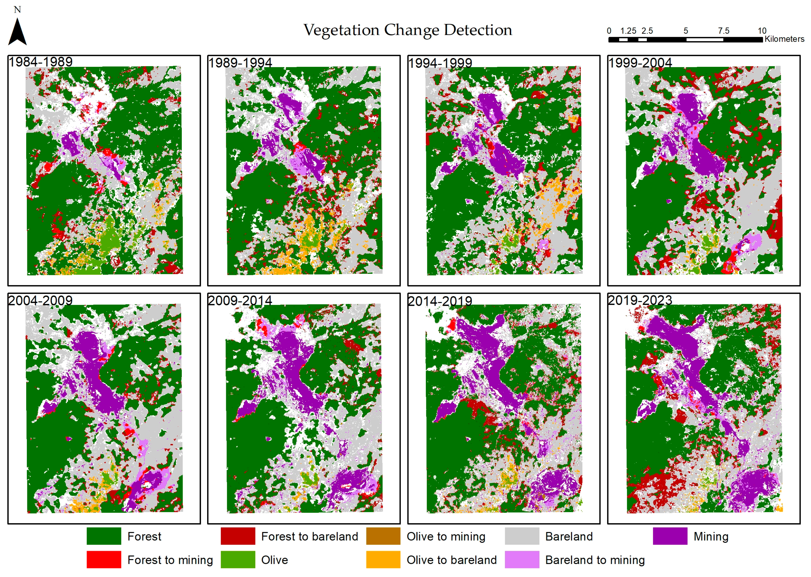
The results show that the conversion from forest to mining area was highest between 2004 and 2009 (126 ha), followed by 1984–1989 (115 ha) and 2009–2014 (111 ha). In addition, 1275 ha of forest area in the study area was converted to bare lands between 2019 and 2023, while this conversion was detected to be 1138 ha between 1999 and 2004 and 869 ha between 2014 and 2019. The area of forests that was converted to bare lands was 32 times larger than that converted to mining areas between 1989 and 1994. Bare lands were primarily observed in the periphery of the mining area (
Figure 2).
Olive groves were found to be transformed into mining areas and barrens. The olive groves in the south were converted into bare lands between 1984 and 1989 (245 ha), 1989 and 1994 (465 ha), and 1994 and 1999 (304 ha), and then, a mining area was opened in the eastern part (
Figure 2).
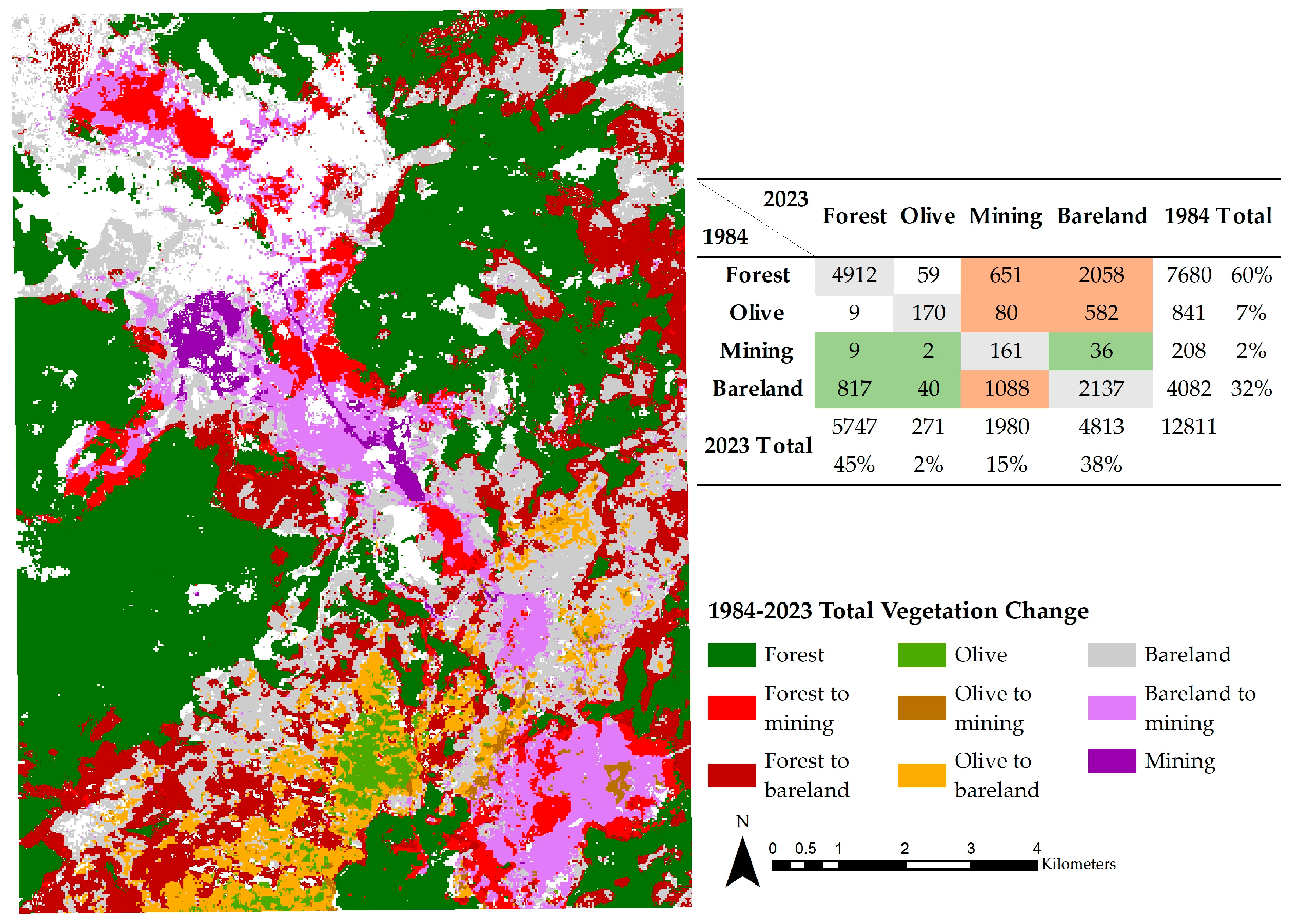
Figure 3 presents the total changes between 1984 and 2023. According to the analysis, 2048 ha of forest area was converted into bare lands, and 615 ha was converted into mining areas (
Figure 3). The total area of forest and olive grove that was turned into mining area was 731 ha, while the total area that became bare land was 2640 ha. On the other hand, 1088 ha of bare lands from 1984, which could have been reforested and restored to vegetation, was converted into a mining area in 2023.
3.2. NDVI Results
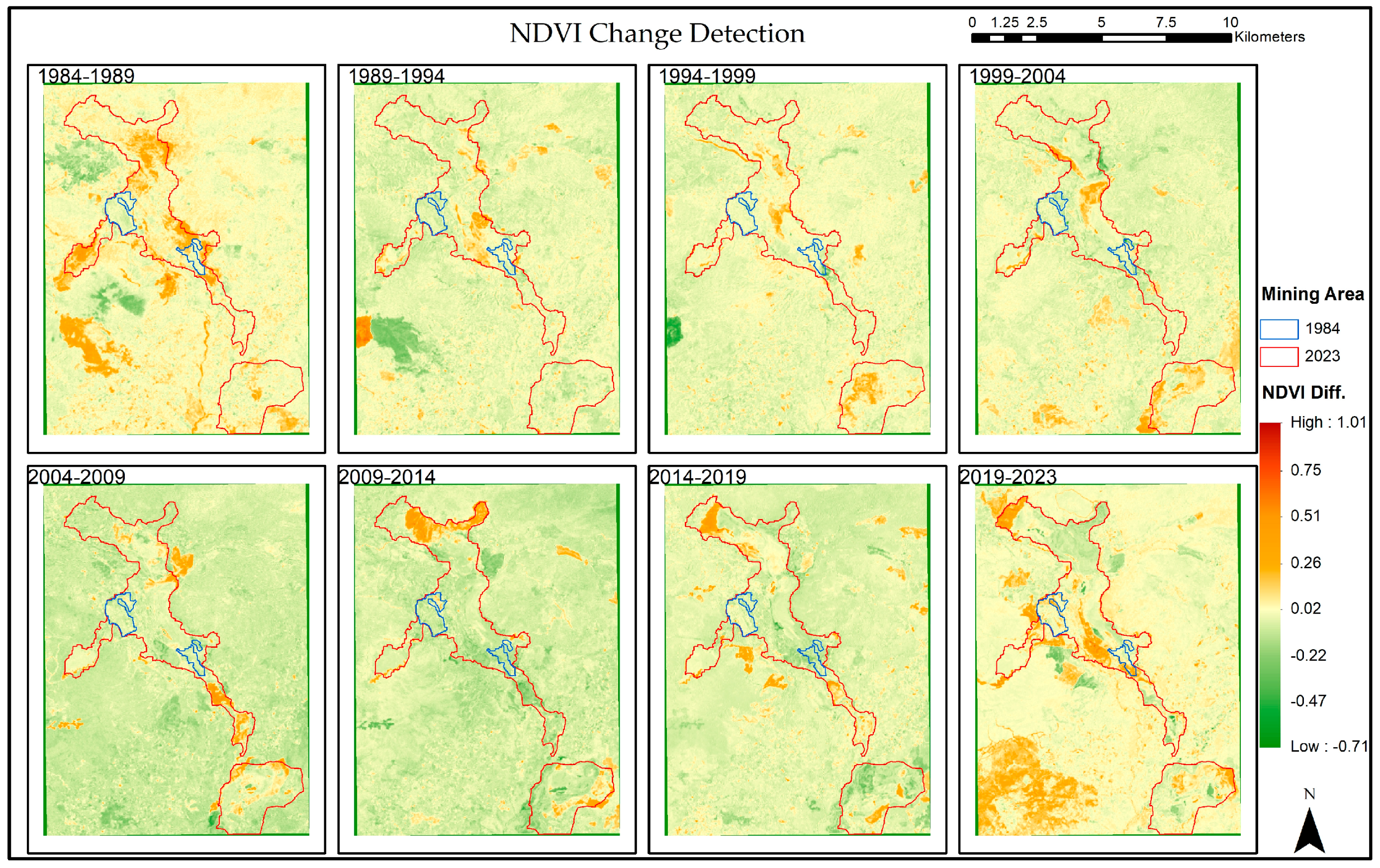
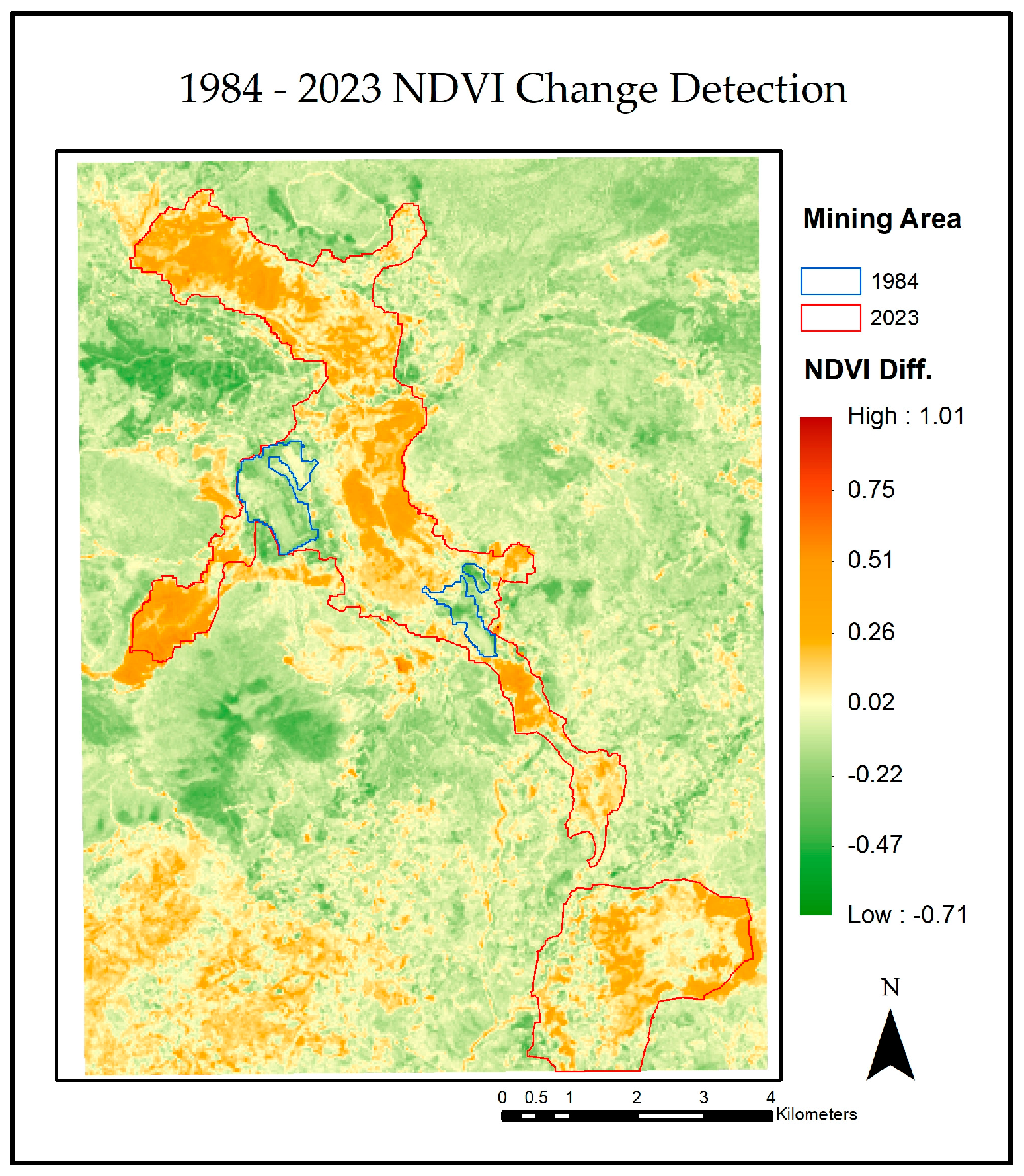
Figure 4 presents 5-year NDVI change maps for the Milas–Ören lignite mines and their surroundings. The boundaries of the mining areas, initially marked in blue for 1984, have been determined to have expanded to the red boundaries by 2023. During this expansion, decreases in the NDVI have been detected within and outside the active mining site.
In the following, NDVI changes for 5-year intervals are summarized:
- -
1989–1994: No significant NDVI changes were recorded within the blue boundaries in 1984, and decreases in vegetation became more prominent in areas outside these boundaries.
- -
1994–1999: A recovery/improvement in vegetation was seen in the west.
- -
1999–2004: Significant NDVI decreases emerged in the mine site’s eastern, northeastern, and southeastern regions, suggesting a broader decline in vegetation.
- -
2004–2009: Increases in NDVI values were detected in the north and east.
- -
2009–2014: A noticeable recovery in the eastern and northeastern regions and decreased vegetation in the west were detected.
- -
2014–2019: Increases in the north and northwest were observed.
- -
2019–2023: Increases in vegetation were encountered in the east and northeast, while a decline in vegetation in the northwest was detected.
The NDVI change detection analysis between 1984 and 2023 revealed significant declines in vegetation, coinciding with the expansion of the mining area (
Figure 5). Especially in the western, northern, and southern regions of the mine, these declines were more intensive. This analysis indicates that the impact of mining activities is not limited to the immediate boundaries of the mine. Rather, it has adverse effects on vegetation over a broader area.
4. Discussion and Conclusions
In this study, LULC and NDVI analyses were carried out in Milas–Ören mines to examine the impact of open cast mines on the vegetation between 1984 and 2023 using Landsat images. In total, 731 ha of vegetated areas has been converted to mining, while 2640 ha has been indirectly affected and damaged by mining. Our LULC change detection analysis showed that forested areas were often transformed into bare lands before being transformed into mining areas. Therefore, the area that changed from forest to mining may be perceived as smaller than the area that changed to bare lands in 5-year comparisons.
The NDVI change maps between 1984 and 2023 indicate that mining activities have had pronounced negative effects on the vegetation. With the expansion of the mining area, decreases in vegetation were observed within and outside the boundaries of the mining site. These changes demonstrate that the environmental impact of mining activities is not limited solely to the direct operational area; these activities also affect the surrounding ecosystem.
Author Contributions
Conceptualization, C.O.-T. and S.N.C.; methodology, C.O.-T. and B.B.; software, C.O.-T. and B.B.; resources, C.O.-T.; data curation, C.O.-T. and B.B.; writing—original draft preparation, C.O.-T. and B.B.; writing—review and editing, S.N.C.; visualization, C.O.-T. and B.B.; supervision, S.N.C. All authors have read and agreed to the published version of the manuscript.
Funding
This study was funded by The Scientific and Technological Research Council of Türkiye (TUBITAK) 2244 program under project number 119C200.
Institutional Review Board Statement
Not applicable.
Informed Consent Statement
Not applicable.
Data Availability Statement
Conflicts of Interest
The funders had no role in the design of the study; in the collection, analyses, or interpretation of data; in the writing of the manuscript; or in the decision to publish the results.
References
- Wolfram, C.; Shelef, O.; Gertler, P. How Will Energy Demand Develop in the Developing World? J. Econ. Perspect. 2012, 26, 119–138. [Google Scholar] [CrossRef]
- Yumurtaci, Z.; Asmaz, E. Electric Energy Demand of Turkey for the Year 2050. Energy Sources 2004, 26, 1157–1164. [Google Scholar] [CrossRef]
- T.C. Enerji ve Tabii Kaynaklar Bakanlığı. Elektrik. 2022. Available online: https://enerji.gov.tr/bilgi-merkezi-enerji-elektrik (accessed on 20 June 2022).
- T.C. Enerji ve Tabii Kaynaklar Bakanlığı. Kömür. 2022. Available online: https://enerji.gov.tr/bilgimerkezi-tabiikaynaklar-komur (accessed on 20 June 2022).
- Türkiye Kömür İşletmeleri Kurumu. Açık Ocak Madenciliği. 2021. Available online: https://www.tki.gov.tr/acik-ocak-madenciligi (accessed on 23 July 2022).
- Üçışık Erbilen, S.; Şahin, G. Enerji Coğrafyasi Kapsaminda Türkiye’de Linyit. Doğu Coğrafya Derg. 2015, 20, 135. [Google Scholar] [CrossRef]
- Karadağ, A. Linyit Işletmeleri ve Termik Santralin Ardindan Soma’da Değişen Çevre, Kent ve Kimlik. Ege Coğrafya Derg. 2006, 15, 31–50. [Google Scholar]
- Çeçen, F. Kömür Madenciliğinin Çevresel Etkileri; Boğaziçi Üniversitesi Çevre Bilimleri Enstitüsü: Istanbul, Türkiye, 2015; p. 17. [Google Scholar]
- Schmidt, H.; Glaesser, C. Multitemporal analysis of satellite data and their use in the monitoring of the environmental impacts of open cast lignite mining areas in Eastern Germany. Int. J. Remote Sens. 1998, 19, 2245–2260. [Google Scholar] [CrossRef]
- Sarp, G. Determination of Vegetation Change Using Thematic Mapper Imagery in Afşin-Elbistan Lignite Basin; SE Turkey. Procedia Technol. 2012, 1, 407–411. [Google Scholar] [CrossRef][Green Version]
- Gül, M.; Zorlu, K.; Gül, M. Assessment of mining impacts on environment in Muğla-Aydın (SW Turkey) using Landsat and Google Earth imagery. Environ. Monit. Assess. 2019, 191, 655. [Google Scholar] [CrossRef] [PubMed]
- Erener, A. Remote sensing of vegetation health for reclaimed areas of Seyitömer open cast coal mine. Int. J. Coal Geol. 2011, 86, 20–26. [Google Scholar] [CrossRef]
- Przeździecki, K.; Zawadzki, J.; Miatkowski, Z. Use of the temperature–vegetation dryness index for remote sensing grassland moisture conditions in the vicinity of a lignite open-cast mine. Environ. Earth Sci. 2018, 77, 623. [Google Scholar] [CrossRef]
- Akanwa, A.O.; Okeke, F.I.; Nnodu, V.C.; Iortyom, E.T. Quarrying and its effect on vegetation cover for a sustainable development using high-resolution satellite image and GIS. Environ. Earth Sci. 2017, 76, 505. [Google Scholar] [CrossRef]
- Gümüşel, D.; Gündüzyeli, E. Kömürün Gerçek Bedeli: Muğla; CAN Europe: İstanbul, Türkiye, 2019. [Google Scholar]
- Muğla İl Kültür ve Turizm İl Müdürlüğü. Coğrafya (Konum-İklim-Ulaşım). Available online: http://mugla.ktb.gov.tr (accessed on 15 December 2022).
| Disclaimer/Publisher’s Note: The statements, opinions and data contained in all publications are solely those of the individual author(s) and contributor(s) and not of MDPI and/or the editor(s). MDPI and/or the editor(s) disclaim responsibility for any injury to people or property resulting from any ideas, methods, instructions or products referred to in the content. |
© 2023 by the authors. Licensee MDPI, Basel, Switzerland. This article is an open access article distributed under the terms and conditions of the Creative Commons Attribution (CC BY) license (https://creativecommons.org/licenses/by/4.0/).
