1. Introduction
Since the inception of satellites in the mid-20th century, remote sensing has experienced revolutionary progress. For decades, satellites were heralded as the epitome of innovation, opening avenues for vast applications across diverse sectors. These celestial instruments, with their birds-eye view of the planet, brought forth new opportunities for scientific, military, meteorological, and environmental applications. [
1,
2,
3]. Their unparalleled reach and ability to capture large expanses of the Earth’s surface rendered them indispensable, reshaping the way humans understand and interact with their environment.
Yet, with the 21st century came a novel and transformative instrument: the unmanned aerial vehicle, commonly known as a drone or UAV. Compact, flexible, and agile, UAVs began to demonstrate vast potential, beyond their initial military applications, notably in fields requiring fine-scale observations, such as agriculture [
4,
5].
Agriculture, a sector as ancient as civilization itself, stands at the cusp of a new era. Precision agriculture—driven by the desire to optimize production and resources—demands accurate, timely, and granular data [
6]. With a growing global population and the threats posed by climate change, ensuring food security has become a paramount concern. The adaptability of agriculture to these challenges hinges upon its incorporation of advanced technologies, among which remote sensing plays a pivotal role [
7]. However, while the rapid integration of remote sensing into agriculture has yielded significant benefits, it also comes with the risk of misapplication. When utilized without a clear understanding of their inherent strengths and limitations, even the most advanced tools can lead to suboptimal decisions, potentially jeopardizing the very objectives they were meant to achieve [
8].
One of the most employed tools are the vegetation indices, which are essential tools in remote sensing that provide a quantifiable measure of plant health and vigor by analyzing the light reflected off the vegetation surface. One of the most widely used vegetation indices is the normalized difference vegetation index (NDVI). The NDVI leverages the difference between near-infrared (which vegetation strongly reflects) and red light (which vegetation absorbs) to assess whether an area contains live green vegetation or not. The values of NDVI range from −1 to 1, with higher values indicating healthier and denser vegetation. NDVI has a clear relationship with satellite images [
9] and, by utilizing NDVI, researchers and agriculturists can monitor crop health, vegetation, assess drought impact, and predict yields [
10,
11,
12,
13], making it a pivotal tool in precision agriculture and the broader realm of environmental monitoring.
Satellites and UAVs, while complementary, serve distinct purposes. Satellites, with their broad reach, offer a macroscopic perspective, capturing vast terrains and temporal patterns. UAVs, in contrast, provide a microscopic lens, capturing finer details and nuances that satellites might overlook [
14]. Their utility becomes especially evident in the cultivation of specific crops that have gained prominence in the wake of changing global climate patterns. A prime example is the pistachio, a crop that has seen a surge in southern Europe, particularly in Spain [
15].
Nevertheless, despite the extended use of satellites for agriculture, a significant knowledge gap persists in their application [
16]. A nuanced, evidence-based approach is required to assess which technology, or combination thereof, is best-suited to specific agronomic scenarios [
17]. This research seeks to bridge this gap, delving deep into the comparative efficiencies of satellite and UAV remote sensing for pistachio orchards in Spain. Through an assessment of agronomical parameters, this study aims to shed light on the intricate interplay between these two technologies, guiding farmers, policymakers, and industry stakeholders towards making informed, future-proof decisions.
2. Materials and Methods
The study was conducted in two distinct pistachio orchards (Pistacia vera L.) located in Valladolid, Spain. The first orchard is situated in La Seca (X: 341,455.662, Y: 4,589,735.763 in ETRS89/UTM zone 30N), whereas the second orchard is located in Moraleja de las Panaderas (X: 347,802.062, Y: 4,570,373.104 in ETRS89/UTM zone 30N). Both orchards exhibit the typical characteristics of pistachio cultivation in the region, and were cultivated free of weeds.
Data from Sentinel 2, a component of the Copernicus Programme dedicated to regular optical imagery acquisition, served as a satellite source (
Figure 1). Interested individuals can freely access this information via the Copernicus ESA Open Access Hub [
https://scihub.copernicus.eu/] (accessed on 30 March 2023). Satellite images were sourced from the closest available dates to the UAV flights. The two dates selected for analysis were 30 June 2022 and 18 September 2022 because they were free from clouds. From these images, the normalized difference vegetation index (NDVI) was derived, which offers insights into the health and vigor of vegetation and is pivotal in agronomical assessments.
The UAV DJI Inspire 2, with a maximum flight time of 27 min, outfitted with the MicaSense Altum sensor, was used in this study. The MicaSense Altum is a multispectral sensor designed specifically for precision agriculture. The Altum captures synchronized multispectral and thermal imagery, providing a complete view of vegetation health and temperature. It has six individual sensors: blue, green, red, red edge, near-infrared (NIR), and a thermal infrared band. These sensors work in tandem to produce images with a resolution of up to 3.2 mpx. With a broad dynamic range, the Altum can capture detailed data even under varying light conditions. Additionally, its fast capture rate facilitates high-speed, low-altitude flight, making it suitable for detailed surveys. Its radiometric calibration ensures data consistency across different flights, making it a reliable choice for longitudinal studies, like the present work.
Ensuring synchronization with Sentinel 2 imagery, flights were scheduled on 24 June 2022 and 7 September 2022. The aircraft was maintained at an average altitude of 30 m during these flights with a photographic overlap of 75%, a strategic choice that ensured comprehensive coverage and optimal image resolution.
Finally, NDVI maps calculated from satellite images and UAV images were compared by calculating the average value of UAV pixels within reach Sentinel 2 pixel, which has a lower resolution than UAV images. Therefore, through the use of QGIS v.3.22 and R software v4.2.X, the performance of satellite measurements was evaluated in comparison to the UAV datasets, which acted as the ‘ground truth’ reference.
3. Results and Discussion
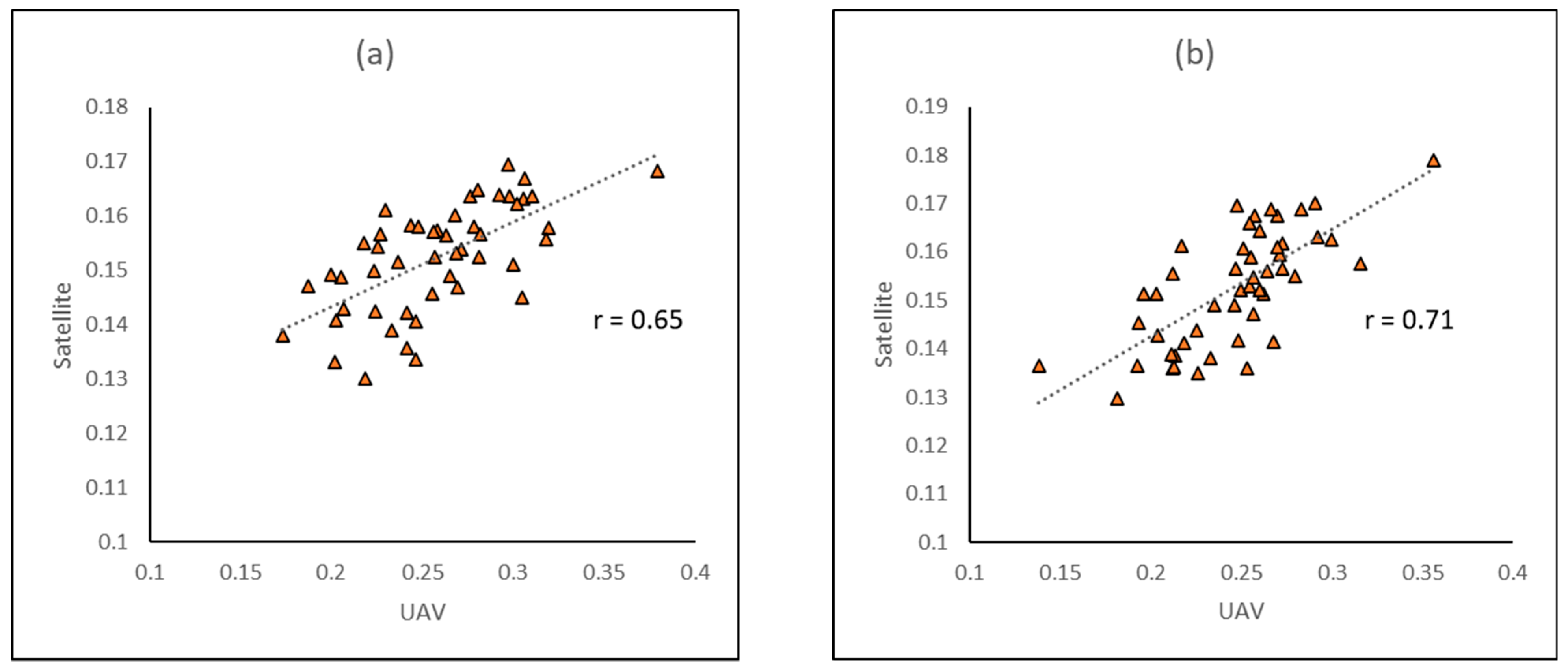
The primary aim was to assess the accuracy of Sentinel 2 in estimating crucial parameters within pistachio orchards. While satellite data consistently underestimated the NDVI values on the map, distinct differences between UAV and satellite data were evident (
Figure 2 and
Figure 3). Still, patterns of NDVI variation within the plot remained observable. A satisfactory data correlation was achieved in both instances, recording an r-value of 0.65 in July between the two spectral information sources. This correlation further improved, reaching r-values as high as 0.71 as the growth cycle progressed and neared harvest time in September.
The study sought to evaluate Sentinel 2’s proficiency in gauging pivotal metrics within pistachio orchards. Notably, the satellite-derived data systematically underrepresented the NDVI values compared to the UAV datasets (refer to
Figure 2 and
Figure 3). However, spatial trends in NDVI within the orchard plots were discernible across both platforms, suggesting that satellite images are enough for zonifying. The correlation between these spectral datasets was commendable, registering an r-value of 0.65 in July. Remarkably, this interrelation bolstered to an r-value of 0.71 by September, paralleling the maturation phase leading up to the harvest season.
4. Conclusions
Precision agriculture, bolstered by satellites and UAVs, holds significant potential for modern agronomy. Our findings indicate a correlation of r up to 0.7 between UAV and Sentinel 2 data, suggesting satellite imagery’s viability for zonification. However, Sentinel 2’s spatial resolution, at up to 10 m, limits the precise estimation of agronomical parameters like vegetation indices.
While Sentinel 2’s frequent revisit time (every 5 days) offers continuous monitoring capabilities, it lacks the granularity that UAVs provide. UAVs, flying at lower altitudes with high-resolution sensors, excel in site-specific evaluations essential for accurate agricultural decisions. In essence, while satellites can track broader trends, UAVs provide the needed precision for detailed agronomic practices. For optimal outcomes in precision agriculture, an integrated approach harnessing both technologies may be most effective.
Further exploration into integrating satellite and UAV data could seamlessly lead to more holistic monitoring systems. Advancements in satellite technology may soon provide higher spatial resolutions, narrowing the current gaps in data precision. Similarly, the development of UAVs with extended flight times or advanced sensors could facilitate deeper insights into agronomic parameters. The research could also focus on machine learning algorithms to more efficiently interpret and synthesize the vast amounts of data generated, as well as improve techniques for satellite and UAV data fusion. Furthermore, the role of other remote sensing technologies, like ground-based sensors or IoT devices, in conjunction with satellites and UAVs, warrants investigation, potentially offering important agricultural data for unparalleled precision.
Author Contributions
Author Contributions: conceptualization, S.V. and R.M.-P.; methodology, S.V., R.V., S.Á. and R.M.-P.; software, S.V., R.V. and R.M.-P.; validation, S.V. and R.M.-P.; formal analysis, S.V. and R.M.-P.; investigation, R.M.-P.; resources, S.V., R.V., S.Á. and R.M.-P.; data curation, S.V., R.V. and R.M.-P.; writing—original draft preparation, S.V. and R.M.-P.; writing—review and editing, S.V., R.V., S.Á. and R.M.-P.; visualization, S.V., R.V., S.Á. and R.M.-P.; supervision, S.V. and S.Á.; project administration, S.Á.; funding acquisition, S.Á. All authors have read and agreed to the published version of the manuscript.
Funding
This work was supported by the project CDTI (IDI-20200822) and by MCIN/AEI/10.13039/501100011033 and European Union «NextGenerationEU»//PRTR, grant number RYC2021-033890. Co-financed by FEADER funds and Junta de Castilla y León (Spain).
Data Availability Statement
The Sentinel 2 datasets supporting the conclusions of this article are available to the public. The satellite data can be accessed through the Copernicus ESA Copernicus Open Access Hub (
https://scihub.copernicus.eu/, accessed on 30 March 2023).
Acknowledgments
The authors acknowledge valuable help and contributions from the members of the Horticultural and Woody Crops group from the ITACyL.
Conflicts of Interest
The authors declare no conflicts of interest.
References
- Amankulova, K.; Farmonov, N.; Mucsi, L. Time-series analysis of Sentinel-2 satellite images for sunflower yield estimation. Smart Agric. Technol. 2023, 3, 100098. [Google Scholar] [CrossRef]
- Anastasiou, E.; Balafoutis, A.; Darra, N.; Psiroukis, V.; Biniari, A.; Xanthopoulos, G.; Fountas, S. Satellite and Proximal Sensing to Estimate the Yield and Quality of Table Grapes. Agriculture 2018, 8, 94. [Google Scholar] [CrossRef]
- Vélez, S.; Rançon, F.; Barajas, E.; Brunel, G.; Rubio, J.A.; Tisseyre, B. Potential of functional analysis applied to Sentinel-2 time-series to assess relevant agronomic parameters at the within-field level in viticulture. Comput. Electron. Agric. 2022, 194, 106726. [Google Scholar] [CrossRef]
- Martínez-Peña, R.; Vélez, S.; Vacas, R.; Martín, H.; Álvarez, S. Remote Sensing for Sustainable Pistachio Cultivation and Improved Quality Traits Evaluation through Thermal and Non-Thermal UAV Vegetation Indices. Appl. Sci. 2023, 13, 7716. [Google Scholar] [CrossRef]
- Vélez, S.; Poblete-Echeverría, C.; Rubio, J.A.; Vacas, R.; Barajas, E. Estimation of Leaf Area Index in vineyards by analysing projected shadows using UAV imagery. OENO One 2021, 55, 159–180. [Google Scholar] [CrossRef]
- Sharma, S.; Srushtideep, A. Precision Agriculture and Its Future. Int. J. Plant Soil Sci. 2022, 34, 200–204. [Google Scholar] [CrossRef]
- Sishodia, R.P.; Ray, R.L.; Singh, S.K. Applications of Remote Sensing in Precision Agriculture: A Review. Remote Sens. 2020, 12, 3136. [Google Scholar] [CrossRef]
- Kušová, D.; Těšitel, J.; Boukalová, Z. Willingness to Adopt Technologies of Precision Agriculture: A Case Study of the Czech Republic; WIT Press: Prague, Czech Republic, 2017; pp. 109–117. [Google Scholar]
- Vélez, S.; Barajas, E.; Rubio, J.A.; Vacas, R.; Poblete-Echeverría, C. Effect of Missing Vines on Total Leaf Area Determined by NDVI Calculated from Sentinel Satellite Data: Progressive Vine Removal Experiments. Appl. Sci. 2020, 10, 3612. [Google Scholar] [CrossRef]
- Bajocco, S.; Ginaldi, F.; Savian, F.; Morelli, D.; Scaglione, M.; Fanchini, D.; Raparelli, E.; Bregaglio, S.U.M. On the Use of NDVI to Estimate LAI in Field Crops: Implementing a Conversion Equation Library. Remote Sens. 2022, 14, 3554. [Google Scholar] [CrossRef]
- de Castro, A.; Six, J.; Plant, R.; Peña, J. Mapping Crop Calendar Events and Phenology-Related Metrics at the Parcel Level by Object-Based Image Analysis (OBIA) of MODIS-NDVI Time-Series: A Case Study in Central California. Remote Sens. 2018, 10, 1745. [Google Scholar] [CrossRef]
- Hassan, M.A.; Yang, M.; Rasheed, A.; Yang, G.; Reynolds, M.; Xia, X.; Xiao, Y.; He, Z. A rapid monitoring of NDVI across the wheat growth cycle for grain yield prediction using a multi-spectral UAV platform. Plant Sci. 2019, 282, 95–103. [Google Scholar] [CrossRef] [PubMed]
- Vélez, S.; Rubio, J.A.; Andrés, M.I.; Barajas, E. Agronomic classification between vineyards (‘Verdejo’) using NDVI and Sentinel-2 and evaluation of their wines. VITIS—J. Grapevine Res. 2019, 58, 33–38. [Google Scholar] [CrossRef]
- Roca, M.; Dunbar, M.B.; Román, A.; Caballero, I.; Zoffoli, M.L.; Gernez, P.; Navarro, G. Monitoring the marine invasive alien species Rugulopteryx okamurae using unmanned aerial vehicles and satellites. Front. Mar. Sci. 2022, 9, 1004012. [Google Scholar] [CrossRef]
- Dhamin, T.A.; Khanjer, E.F.; Mashee, F.K. The Effect of Temporal Resolution of Climatic Factors on Agriculture Degradation in Southern Baghdad by Applying Remote Sensing Data. Iraqi J. Sci. 2023, 64, 994–1006. [Google Scholar] [CrossRef]
- Van Der Meer, M.; Kay, S.; Lüscher, G.; Jeanneret, P. What evidence exists on the impact of agricultural practices in fruit orchards on biodiversity? A systematic map. Environ. Evid. 2020, 9, 2. [Google Scholar] [CrossRef]
- Steenwerth, K.L.; Hodson, A.K.; Bloom, A.J.; Carter, M.R.; Cattaneo, A.; Chartres, C.J.; Hatfield, J.L.; Henry, K.; Hopmans, J.W.; Horwath, W.R.; et al. Climate-smart agriculture global research agenda: Scientific basis for action. Agric. Food Secur. 2014, 3, 11. [Google Scholar] [CrossRef]
| Disclaimer/Publisher’s Note: The statements, opinions and data contained in all publications are solely those of the individual author(s) and contributor(s) and not of MDPI and/or the editor(s). MDPI and/or the editor(s) disclaim responsibility for any injury to people or property resulting from any ideas, methods, instructions or products referred to in the content. |
© 2023 by the authors. Licensee MDPI, Basel, Switzerland. This article is an open access article distributed under the terms and conditions of the Creative Commons Attribution (CC BY) license (https://creativecommons.org/licenses/by/4.0/).


