1. Introduction
The dual system of land administration in Spain, consisting of the Cadastre and the Land Registry, is currently immersed in a process of coordination between both institutions thanks, to a large extent, to Law 13/2015. This law establishes a set of actions and procedures to be taken into account in order to achieve the desired coordination in the geometric aspect but also in terms of ownership [
1,
2].
In relation to the Cadastre, as an administrative register for tax purposes of the plots that make up our territory, it is defined by a geometric component, being the cadastral geometry, and another alphanumeric component, which includes all the information on the ownership, economic valuation, and identification data of each of the plots. This alphanumeric information has, over the years, in most cases, not been updated as diligently as it should have been and has led to a lack of updating, especially in the information referring to cadastral ownership.
It is very common, for the professions of topographer, land surveyor, and geomatics engineer specialised in property, to come across plots with cadastral owners who are unidentified deceased persons, either by ID card or fiscal address, born at the end of the 19th century; identified persons, who have also died in recent decades; or even plots with an unknown owner or under investigation, according to cadastral jargon. The aim of this article is to show an estimation of the number of plots with this problem in a case study at the municipal level in a Spanish rural area in the province of Albacete. This study will show the situation of abandonment in terms of cadastral ownership and justify the need to make appropriate decisions to improve the Spanish land administration system. These decisions are aligned with Sociological Geomatics [
3,
4,
5], i.e., the use of population information in Geomatics, and in this case, with the aim of updating cadastral ownerships.
2. Materials and Methods
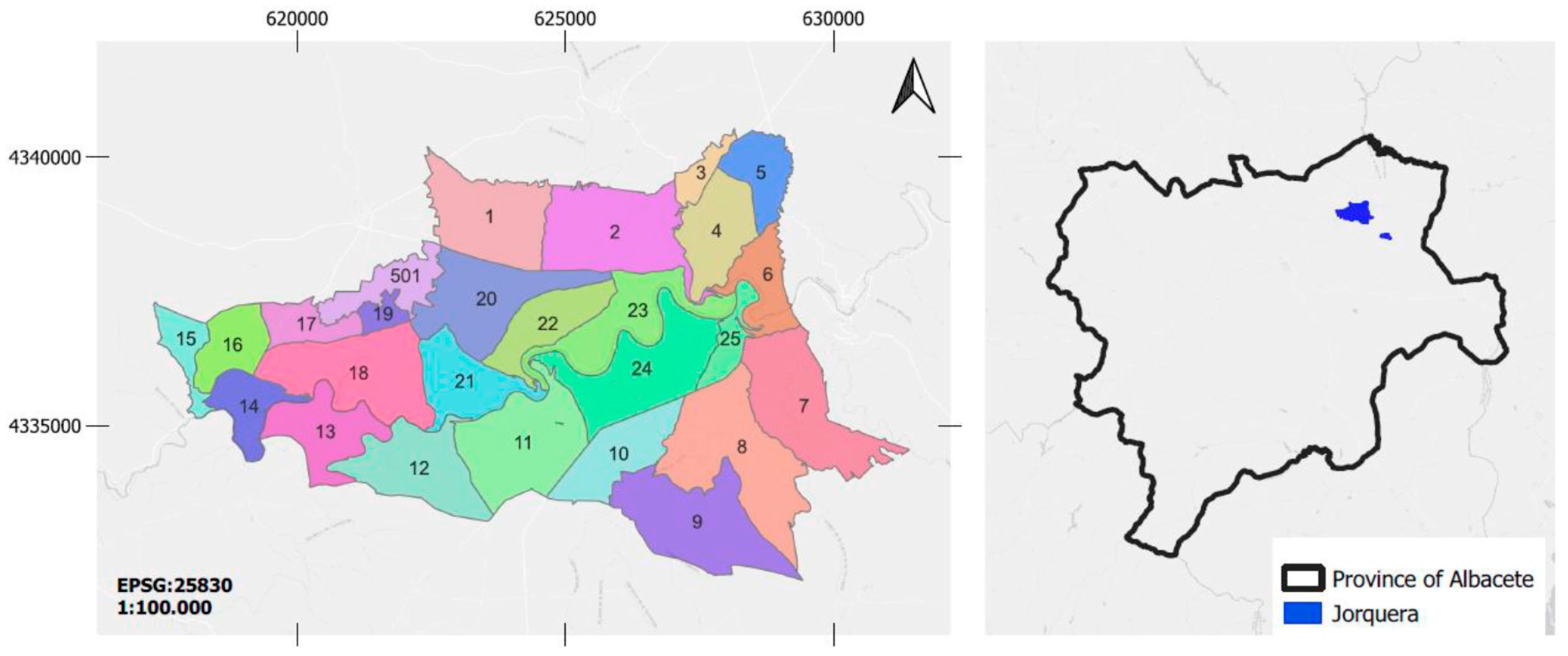
The lack of updating of cadastral ownership is an issue that mostly concerns rural properties in a rural environment. Cadastral plots in rural areas, where depopulation is also a major challenge, often suffer from this problem. For this reason, a town in La Mancha, with less than 300 inhabitants, in the province of Albacete, called Jorquera, has been selected as the case study. The municipality of Jorquera, of some 68 square kilometres, is divided into 28 cadastral polygons, as shown in
Figure 1.
In order to carry out this study, the geometric cadastral layer of the municipal district was used, as well as protected information on cadastral ownership. In addition, in order to verify or accredit that the cadastral owner is alive or already deceased, these ownerships have been checked against a genealogical database created specifically for this purpose, which contains the births and deaths of all the inhabitants of the municipality for at least the last 150 years [
6].
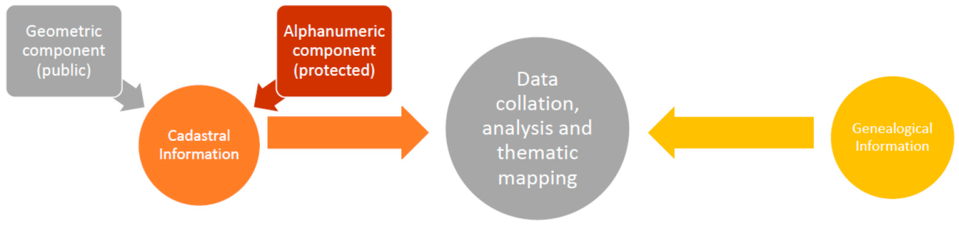
This genealogical database, because it is based on official information from the Civil Registry, is a reliable source of information. Therefore, the cadastral ownerships can be accurately compared with this database, and it is possible to show which ownerships are up to date and which are not. The joint processing of the information referred to, as well as obtaining the statistics and the thematic cartography, has been carried out with QGIS and Python.
Figure 2 shows the workflow followed and the source of data in each of the processes. As mentioned above, this study used geometric and alphanumeric cadastral data with cadastral ownership on the one hand and a genealogical database on the other. These data have been related and analysed jointly in the GIS, and it has been possible to obtain some statistics and thematic cartographic maps of great interest.
3. Results and Discussion
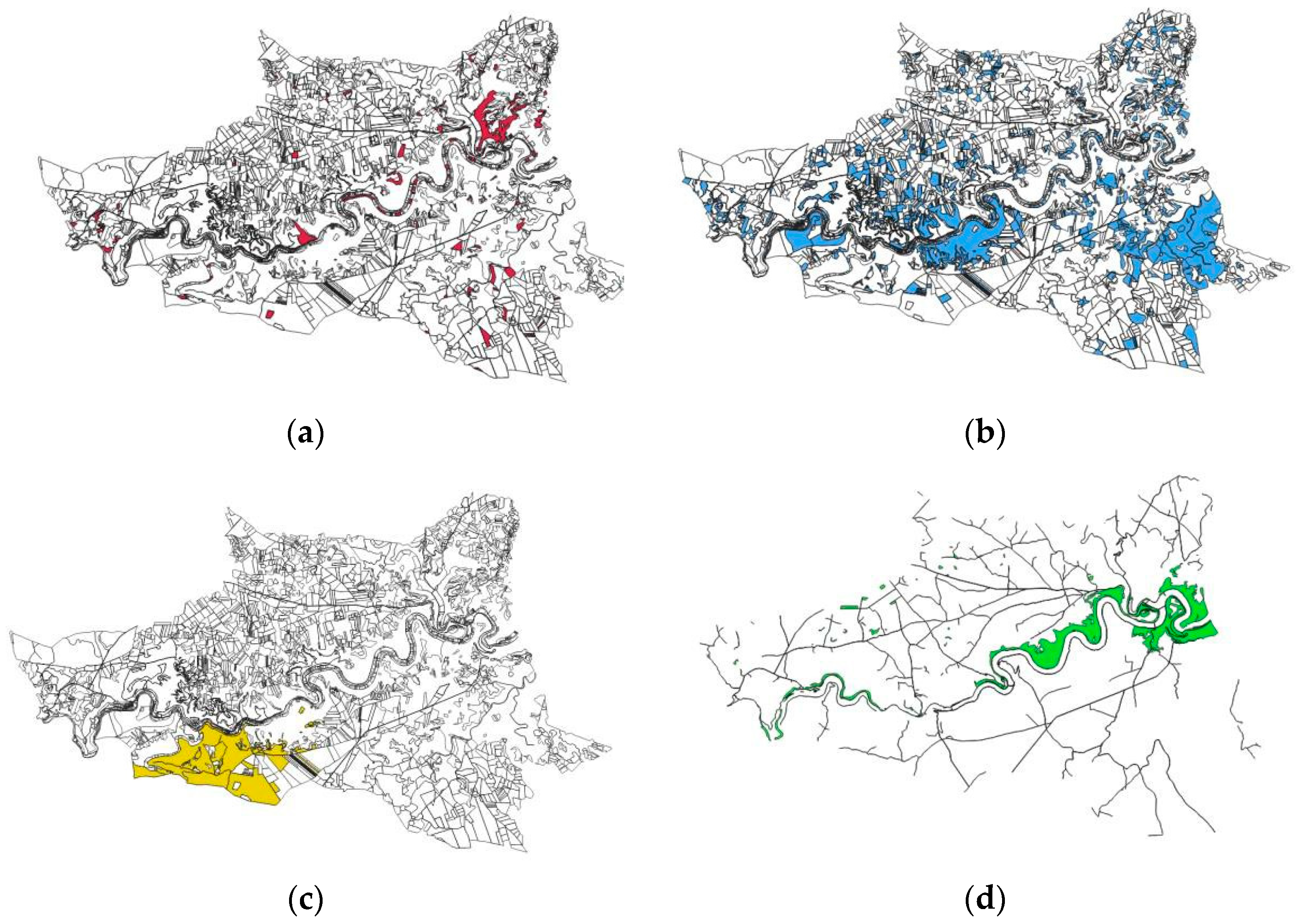
The 28 cadastral polygons that make up the municipality of Jorquera are, in turn, made up of 4703 rustic plots, as shown in
Figure 3. In total, for 47% of these plots, the cadastral titleholder is deceased, and the vast majority are not identified by NIF. In terms of surface area, these represent 35% of the total surface area of the municipality. With regard to the plots with owners unknown to the Cadastre and, therefore, in cadastral jargon, under investigation, there are almost two hundred of them, and they represent around 4%. In terms of surface area, they represent only 2% of the total surface area of the municipality. In this category of plots under investigation, there is a grazing area of more than 37 hectares, but most of these plots have a surface area of less than 1 hectare.
It is worth mentioning that the largest owner, both in terms of surface area and number of plots, is a resident of Valdeganga (Albacete) with 50 cadastral plots in the El Sabinar area, totalling some 300 hectares. In the same way, public lands such as paths and roads, whether belonging to the Jorquera Town Council, the Albacete Provincial Council or the Junta de Comunidades of Castilla-La Mancha, represent 16% of the total surface area of the municipality.
These are some of the preliminary results, but it should be noted that the cadastral ownerships of 37% of the land in Jorquera are not up to date, either because of death or because they are unknown. The predominant land structure in this town is smallholdings, despite the case mentioned above. It is hoped that the results obtained will raise awareness in the near future, particularly among the administration and professionals in the sector, of the critical situation of the issue in question. Furthermore, it is hoped that this will trigger the adoption of a set of political and technical measures at the state level that will converge to resolve the issue in the coming years.
4. Conclusions
The need to update cadastral ownership, especially in rural areas, has been demonstrated in this study, where more than a third of the cadastral area of Jorquera does not have an updated cadastral ownership. This is unacceptable in a society that is supposed to be advanced and modern, where not only the search for but also the achievement of improvements in the land administration system should be a matter of State.
The social or population component combined with the geometric and geographic components is increasingly adopting an important role in decision making in public policies related to territorial development. This is evidence that sociological geomatics, a term coined by the corresponding author, is beginning to become a discipline of great relevance and usefulness.
Author Contributions
Conceptualization, methodology, investigation, writing—original draft preparation, A.C.; writing—review and editing, supervision, F.B.-M. and D.H.-L.; funding acquisition, A.C. All authors have read and agreed to the published version of the manuscript.
Funding
This research was funded by Fundación ONCE in its grant programme Oportunidad al Talento in the IX Edition.
Institutional Review Board Statement
Not applicable.
Informed Consent Statement
Not applicable.
Data Availability Statement
The data that support the findings of this study are available from the corresponding author upon reasonable request.
Acknowledgments
The authors would like to thank the Ayuntamiento de Jorquera (Albacete) and the Dirección General de Catastro for their collaboration in this study.
Conflicts of Interest
The authors declare no conflicts of interest.
References
- Antón Merino, A.; Garrido-Villén, N. Manual técnico y Jurídico de Delimitación Inmobiliaria; Tirant lo Blanch: Valencia, Spain, 2021. [Google Scholar]
- Durán-Boo, I.; Velasco, A. La relación entre el Catastro y el Registro de la Propiedad en los países de la Unión Europea. CT Catastro 2007, 61, 7–30. [Google Scholar]
- Simón-García, M.M. Familia, Propiedad y Grupos Sociales en la Tierra de Jorquera a Mediados del Siglo XVIII: Un Espacio Rural Diferenciado. Trabajo Final Diploma de Estudios Avanzados, Universidad de Castilla-La Mancha, España. 2007. Available online: https://dialnet.unirioja.es/descarga/articulo/3077449.pdf (accessed on 15 June 2023).
- Collado, A.; Buchón-Moragues, F.; Lerma, J.L. Genealogía y Propiedad: Información poblacional histórica para la geolocalización de fincas rústicas. Presented at XII Congreso Internacional de Geomática y Ciencias de La Tierra (TOPCART 2022), Sevilla, Spain, 27–28 October 2022. [Google Scholar]
- Collado, A.; Lerma, J.L. Preservación de los apellidos españoles como patrimonio cultural inmaterial. In Proceedings of the II Simposio de Patrimonio Cultural ICOMOS España, Cartagena, Spain, 17–19 November 2022. [Google Scholar]
- Collado, A.; Buchón-Moragues, F.; Lerma, J.L. El tema INSPIRE sobre la distribución de la población y demografía. Presented at XIII Jornadas Ibéricas de Infraestruturas de Datos Espaciales (JIIDE2022), Sevilla, Spain, 25–27 October 2022. [Google Scholar]
| Disclaimer/Publisher’s Note: The statements, opinions and data contained in all publications are solely those of the individual author(s) and contributor(s) and not of MDPI and/or the editor(s). MDPI and/or the editor(s) disclaim responsibility for any injury to people or property resulting from any ideas, methods, instructions or products referred to in the content. |
© 2023 by the authors. Licensee MDPI, Basel, Switzerland. This article is an open access article distributed under the terms and conditions of the Creative Commons Attribution (CC BY) license (https://creativecommons.org/licenses/by/4.0/).


