Abstract
Lightning potential index (LPI) is a measure of the potential for charge generation and separation that leads to lightning flashes in convective thunderstorms and can be forecasted from NWP models. While the connection between cloud microphysics and lightning seems apparent, the common indices used for forecasting thunderstorms and the potential for lightning usually rely on stability and thermodynamic indices. Herein, an effort is made to correlate LPI high-resolution forecasts with observed lightning from local networks. In this way, the usefulness of the LPI for predicting lightning for the Greek territory and its significance as a tool for improving the weather forecasting of convective storms and heavy rainfall are demonstrated. In addition, a statistical evaluation of precipitation and lightning forecasts with novel spatial methods on selected intense precipitation events is performed by comparing them with gridded observation datasets, and the correlation of the results is determined.
1. Introduction
Lightning, a sudden and powerful electrical discharge, is a common characteristic of severe weather convective conditions. Lightning forecasting is a complex and challenging task that requires a detailed understanding of the atmospheric conditions that give rise to thunderstorms and the electrical processes that produce lightning. One approach involves the use of weather radar and satellite data to identify areas of convective activity and determine the likelihood of thunderstorm development. This information can then be combined with various indices of atmospheric instability and moisture content. Real-time information on the location and intensity of lightning strikes is provided by lightning detection networks.
Lightning forecasting is a complex and challenging task which requires a detailed understanding of the atmospheric conditions that give rise to thunderstorms and electrical processes that produce lightning. One approach to lightning forecasting involves the use of weather radar and satellite data to identify areas of convective activity and determine the likelihood of thunderstorm development. This information can then be combined with models of atmospheric instability, moisture content, as well as convection parameters to generate lightning forecasts for a given region. Another approach involves the use of lightning detection networks, which can provide real-time information on the location and intensity of lightning strikes.
Meteorologists employ various thermodynamic indices to predict the likelihood of thunderstorms. However, these indices are not based on the microphysics of charge separation within thunderstorms. Instead, they rely on thermodynamic instability parameters, producing outputs at a coarse scale. The LPI, a more sophisticated index introduced by Lynn and Yair [1], is a measure of the potential for charge generation and separation that leads to lightning flashes in convective thunderstorms and can be calculated from high-resolution numerical prediction models. The use of the LPI provides valuable insights into the likelihood of lightning activity within convective thunderstorms, enabling meteorologists to issue timely and accurate warnings.
In this study, an effort is made to correlate LPI model output with observed lightning in the Greek territory in order to investigate if it can be a useful parameter for predicting lightning as well as a tool for improving weather forecast of convective storms and heavy rainfall. A statistical evaluation of LPI forecasts with traditional dichotomic scores on a selected intense convective event is also performed by comparing gridded lightning data with model forecasts. Then, indices are intercompared in order to determine their relative value in forecasting the presence of lightning during a convective event.
2. Materials and Methods
2.1. Lightning Formation
The formation of precipitation particles within convective clouds is a complex task involving microphysical processes that lead to charge separation and the buildup of electric fields. One such mechanism is the noninductive mechanism, which involves rebounding collisions between graupel particles and cloud ice crystals and requires the presence of supercooled liquid water [2]. The LPI measures the potential charge separation within the charge separation region of clouds between temperatures of 0 °C and −20 °C and is calculated from model-simulated updraft and microphysical fields [3]. It is a column integral involving the square of the vertical velocity and the presence of graupel (=riming process) and other ice hydrometeors at the same locations. It needs explicitly simulated convective cells with realistic updraft speeds. A calculation of the LPI from cloud-resolving atmospheric model output fields can provide maps of the microphysics-based potential for electrical activity and lightning flashes.
2.2. Methodology
The COSMO-GR4 forecasts were used for this study. The COSMO model is a limited-area hydrostatic atmospheric model developed and maintained by the COSMO Consortium (COn-sortium for Small-scale Modeling, www.cosmo-model.org). The horizontal resolution of the model that was used was 0.04° (~4 km). The grid covered an extended area that covers the Mediterranean region and contains 80 vertical levels. Initial conditions from the ECMWF (European Center of Medium Range Forecast) were incorporated, while the dimensions of the tables retrieved around Greece for each parameter were 800 × 1000 points.
The LPI can only be calculated explicitly with model configuration that enables graupel microphysics (itype_gscp = 4) or 2-moment microphysics. Results for the LPI are only meaningful in convection resolving mode, i.e., deep convection parameterization switched off and grid spacing smaller than or equal to 4 km. Apart from the LPI that is a direct model output, thermodynamic indices were calculated based on other model-derived variables.
Forecast gridded fields: For the original resolution, the LPI value of each grid point was checked, and if it was higher than a given threshold, a value of 1 was assigned. Following that, grids with increased (multiple) resolution based on the original dimensions were created (e.g., 0.04 × 2, ×3, …, ×20). For each new enlarged grid cell, the maximum LPI value of the original points included in each new grid cell was assigned. The LPI value that corresponds to the presence of lightning according to the local climatology was found to be related to the season, and for the October to February wintery period, it had to be higher than 0.5 J/kg [4].
Observation gridded fields: For all upscaled resolution grids ranging from 0.04 deg to 20 × 0.04 deg, a lat–lon-based check was performed along the boundaries of each grid cell for the existence of lightning observations, and a value of 1 was assigned to that grid point for positive checks, or otherwise, a value of zero. Lightning strike information was retrieved from Hellenic National Service network.
Statistical evaluation: To assess LPI forecast performance, a direct comparison of observed and forecasted gridded values was performed with the calculation of contingency table properties [5]. Based on this, Probability Of Detection of event (POD), False Alarm Rate (FAR), Equitable Threat Score (ETS), and Frequency Bias (FBI) indices were calculated for all subsequent grid sizes.
2.3. Thermodynamic Indices
Stability indices were calculated using temperature and relative humidity profiles from the COSMO-GR4 model forecasts with only CAPE (see definition below) being a direct model output. The formulas used for the estimation of the various indices in this analysis are specified below.
2.3.1. K Index (KI)
This calculates the thunderstorm potential based on the vertical temperature lapse rate between 850 and 500 hPa pressure levels, moisture content at 850 hPa pressure, and moist layer depth at 700 hPa pressure [6].
with the suffix values indicating the pressure level. The critical values of the KI index indicating thunderstorm activity [7] are given in Table 1.

Table 1.
Critical values for the K index.
2.3.2. Total Totals Index (TTI) and Improved TTI
The TTI is procured by basic deduction among temperature and dew point temperature values at 850 and 500 hPa pressure levels [8]. The index is calculated through the equations below.
The improved total totals index is obtained from the average of the temperatures at the surface (at 2 m) and the 925 hPa and 850 hPa pressure levels.
The threshold for thunderstorm occurrence is usually seen at 57 K.
2.3.3. Humidity Index (HI)
This is obtained by calculating the availability of water vapour at 850, 700, and 500 hPa pressure levels. The importance of relative humidity as the major component needed for severe thunderstorm activities is estimated by this index.
When the HI values are less than or equal to 30 K, a high possibility of thunderstorm occurrence is noticed in that region.
2.3.4. Convective Available Potential Energy (CAPE)
The buoyant energy required to accelerate an air parcel vertically is referred to as CAPE. The sum of positive buoyant energy from the level of free convection to the equilibrium level can be used to measure it [9].
The represents the parcel’s virtual temperature and represents the virtual temperature of the environment, respectively; x and y denote the level of free convection and neutral buoyancy. The critical values of the CAPE index [10] are given in Table 2.

Table 2.
Critical values for the CAPE index.
3. Analysis Results
For the application of the methodology, various test cases with significant convective precipitation amounts around Greece were analyzed; however, one of them is presented in this paper.
3.1. Test Case: 24 Nov 2019—Synoptic Conditions
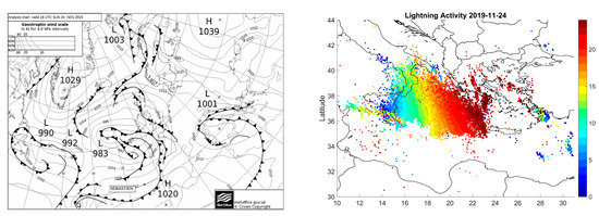
Deep low pressure over Italy moved eastwards accompanied by a cold front over the Ionian Sea, which affected the whole of Greece and caused severe damage due to heavy rainfall. Floods were reported in South Attica, Rhodes, Central Macedonia, and the Eastern Aegean Islands. Strong southerly gale winds of 9Bf over all seas were also reported. Additionally, the system was accompanied by intense snowfall over the mainland mountains (Figure 1).

Figure 1.
(Left): surface analysis map of 24 November 2019, 18UTC. (Right): map of electrical discharges from the HNMS operational lightning network, with the colors indicating the hour of the day with lightning activity.
3.2. Evaluation of LPI Forecasts
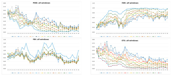
In this section, the statistical results of the evaluation of the upscaled forecast fields against observation are presented (Figure 2). Overall, from all indices, the LPI forecasts had good performance even with the original resolution, and even if, naturally, the scores were least successful for the 0.04 deg window size. The POD (optimal value 1) skill was reduced with lead time. The FAR score (optimal value 0) reached adequate skill for a resolution higher than 10 × 0.04~40 km. As the FBI indicates the tendency of the forecasts, an overestimation was found in the daytime for the original resolution, especially at noon, with a tendency of underestimation at night. With an increasing window, a small underestimation was shown in all upscaled LPI predictions with respect to the original grid performance. Finally, the ETS values revealed that the performance increased linearly with the window size, and for windows higher than 40 km, there was a quite good skill in the LPI.

Figure 2.
POD, FAR (first raw), FBI, and ETS (second raw) for various forecast times during the event and for increasing spatial resolutions (windows).
3.3. Forecasted Thermodynamic Indices and Comparison with LPI Forecasts
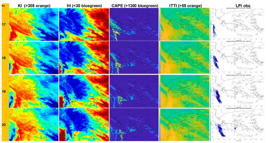
Using the necessary forecasted fields in the original resolution, the thermodynamic indices of Section 2 were calculated and plotted accordingly (Figure 3). Appropriate color pallets were utilized for each index in order to signify areas with a high probability of convection, while in the figure, the colors also indicate that each index is linked with an increased possibility for thunderstorm activity.

Figure 3.
Mapped thermodynamic indices (from left to right: KI, HI, CAPE, and ITTI) against observed lightning strikes (right column) for several time intervals (17-21UTC, rows). The color with the index value connected with increased thunderstorm activity is listed on the first row.
The evolution of the event is provided for the period of 17-21UTC of 24.11.2019. In the last column, the actual presence of lightning strikes is mapped as this resulted from the observed gridded field that was calculated earlier for a qualitative comparison. Even though the presence of convectivity was extracted from all indices, there was no exact representation of the observed field from any of those, and it seems that there was an overall overestimation of the affected area in the same manner as that shown in the original resolution in the LPI forecasts. The CAPE thermodynamic index seems to be more closely correlated with the observed areas affected by lightning strikes.
4. Recommendations
In this paragraph, the main outcomes from the work performed are summarized. An LPI direct forecast can be useful; however, it is necessary to derive LPI products upscaled to a resolution multiple times higher than the original one in order for this forecast to gain reliability. The LPI raw values need to be thresholded according to the area and period examined. Further study for longer periods is necessary in order to determine what thresholds are appropriate for the specific geographic area. A general overestimation of the presence of lightning was derived when the native resolution was used.
Forecasters are able to anticipate lightning activity from model outputs such as CAPE or postprocessed thermodynamic indices even with less accuracy in the location. The thresholds for these indices also need to be appropriately defined in order to provide a useful indication of a potential thunderstorm area. Default values often do not apply to specific geographical areas and seasons. For our case study, the CAPE convective index proved to be the most useful for representing lightning activity and the added value of direct LPI forecasts was not significant in the original resolution. However, LPI forecasts with the appropriate threshold calibration and upscaling can be useful in distinguishing lightning-producing storms, and this may be of importance to specific user groups. Despite advances in lightning forecasting technology, predicting the exact timing and location of lightning strikes remains a challenging and ongoing area of research.
Author Contributions
Conceptualization, F.G.; methodology, F.G. and I.S.; software, I.S.; validation, D.B. and F.G.; formal analysis, F.G. and P.L.; investigation, F.G.; resources, F.G, I.S., D.B. and P.L.; data curation, I.S. and F.G.; writing—original draft preparation, F.G.; writing—review and editing, P.L., D.B. and F.G.; visualization, I.S.; supervision, F.G. and P.L. All authors have read and agreed to the published version of the manuscript.
Funding
This research received no external funding.
Institutional Review Board Statement
Not applicable.
Informed Consent Statement
Not applicable.
Data Availability Statement
Data available upon request to the corresponding author.
Conflicts of Interest
The authors declare no conflict of interest.
References
- Lynn, B.H.; Yair, Y. Lightning Potential Index: A new tool for predicting the lightning density and the potential for extreme rainfall. In Geophysical Research Abstracts; EGU2008-A-01571, SRef-ID: 1607-7962/gra/EGU2008-A-01571; EGU General Assembly: Vienna, Austria, 2008; Volume 10. [Google Scholar]
- Saunders, C.P.R. Charge separation mechanisms in clouds. Space Sci. Rev. 2008, 137, 335–353. [Google Scholar] [CrossRef]
- Lynn, B.; Yair, Y. Prediction of lightning flash density with the WRF model. Adv. Geosci. 2010, 23, 11–16. [Google Scholar] [CrossRef]
- Blahak, U. LPI (Lightning Potential Index) Derived from COSMO-DE Fields, COSMO General Meeting Wroclaw 2015. Available online: https://www.cosmo-model.org/content/consortium/generalMeetings/general2015/parallel/lpi_blahak.pdf (accessed on 28 May 2022).
- Wilks, D.S. Statistical Methods in the Atmospheric Sciences; Academic Press: Cambridge, MA, USA, 1995; 464p. [Google Scholar]
- George, J.J. Weather Forecasting for Aeronautics; Academic Press: Cambridge, MA, USA, 2014. [Google Scholar]
- Johnson, D.L. A Stability Analysis of AVE-4 Severe Weather Soundings; NASA TP-2045 13: 8; NASA: Washington, DC, USA, 1982.
- Miller, R.C. Notes on Analysis and Severe Storm Forecasting Procedures of the Military Weather Warning Center; Tech. Report 200; AWS; USAF: Washington, DC, USA, 1967. [Google Scholar]
- Moncrieff, M.W.; Miller, M.J. The dynamics and simulation of tropical cumulus and squall lines. Q. J. R. Meteorol. Soc. 1976, 102, 373–394. [Google Scholar] [CrossRef]
- Grieser, J. Convection Parameters. 2012. Available online: http://www.juergen-grieser.de/CovectionParameters/ConvectionParameters.pdf (accessed on 11 October 2022).
Disclaimer/Publisher’s Note: The statements, opinions and data contained in all publications are solely those of the individual author(s) and contributor(s) and not of MDPI and/or the editor(s). MDPI and/or the editor(s) disclaim responsibility for any injury to people or property resulting from any ideas, methods, instructions or products referred to in the content. |
© 2023 by the authors. Licensee MDPI, Basel, Switzerland. This article is an open access article distributed under the terms and conditions of the Creative Commons Attribution (CC BY) license (https://creativecommons.org/licenses/by/4.0/).