
GIS-Based Multi-Criteria Decision Analysis for Flash Flood Hazard and Risk Assessment: A Case Study of the Eastern Minya Watershed, Egypt †


Abstract
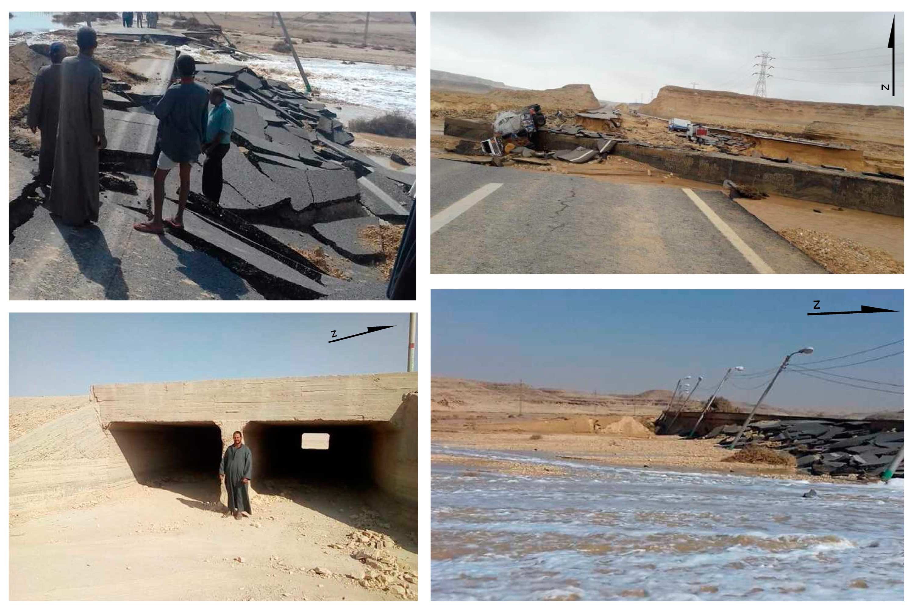
1. Introduction
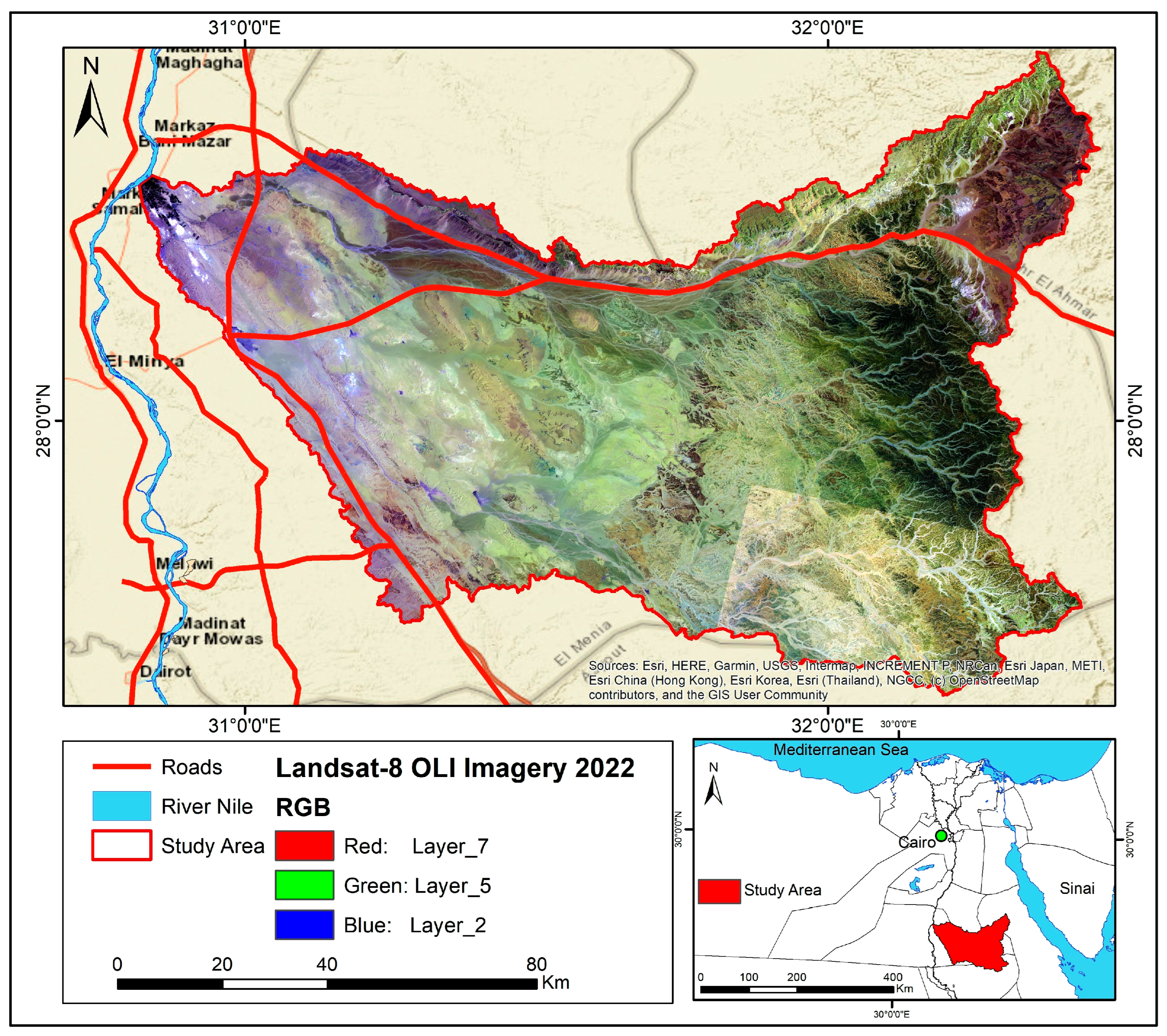
2. Study Area
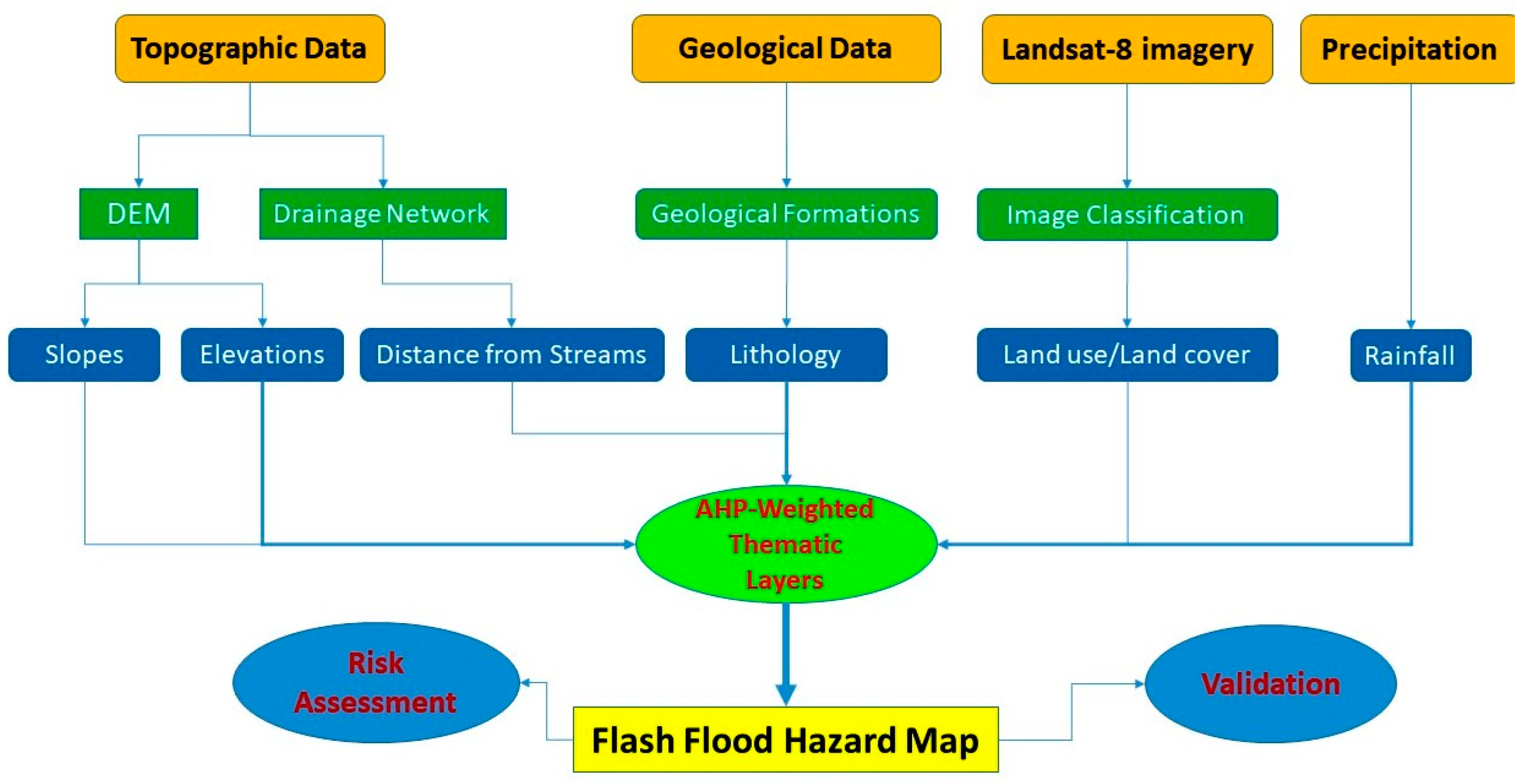
3. Materials and Methods
3.1. Lithological Data
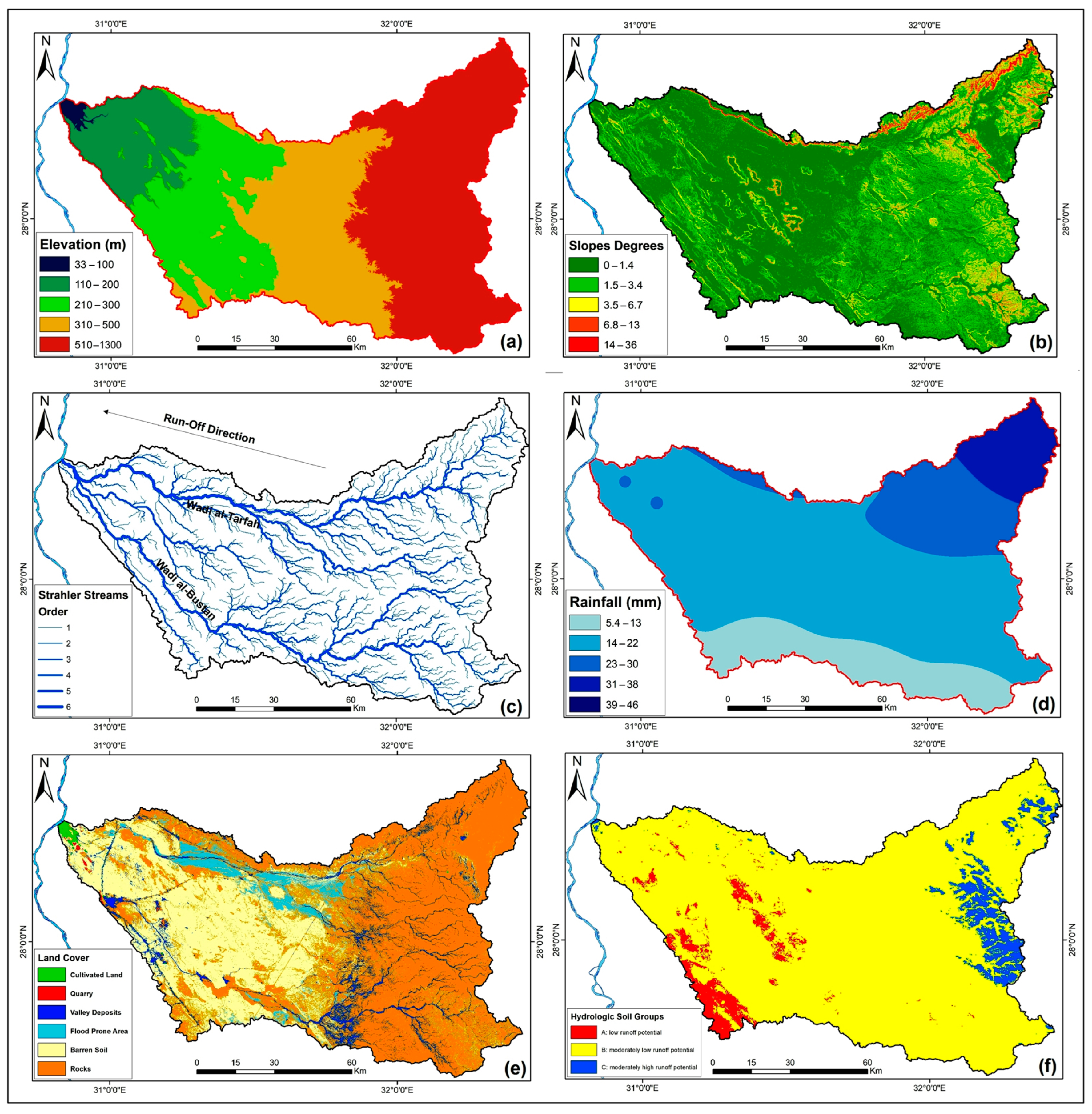
3.2. Topography
3.3. Watershed Delineation
3.4. Rainfall (mm)
3.5. Land Use/Land Cover (LU/LC)
3.6. Hydrological Soil Group (HYSOGs250m)
4. Results and Discussion
4.1. Topographic Hazard Zonation
4.2. Slopes Hazard Zonation
4.3. Distances from Wadis (Rivers) Zonation
4.4. Drainage Density Hazard Zonation
4.5. The Permeability Hazard Map
4.6. The Soil Group Hazard Zonation
4.7. Land Use/Land Cover Hazard Map
4.8. The Precipitation Hazard Map
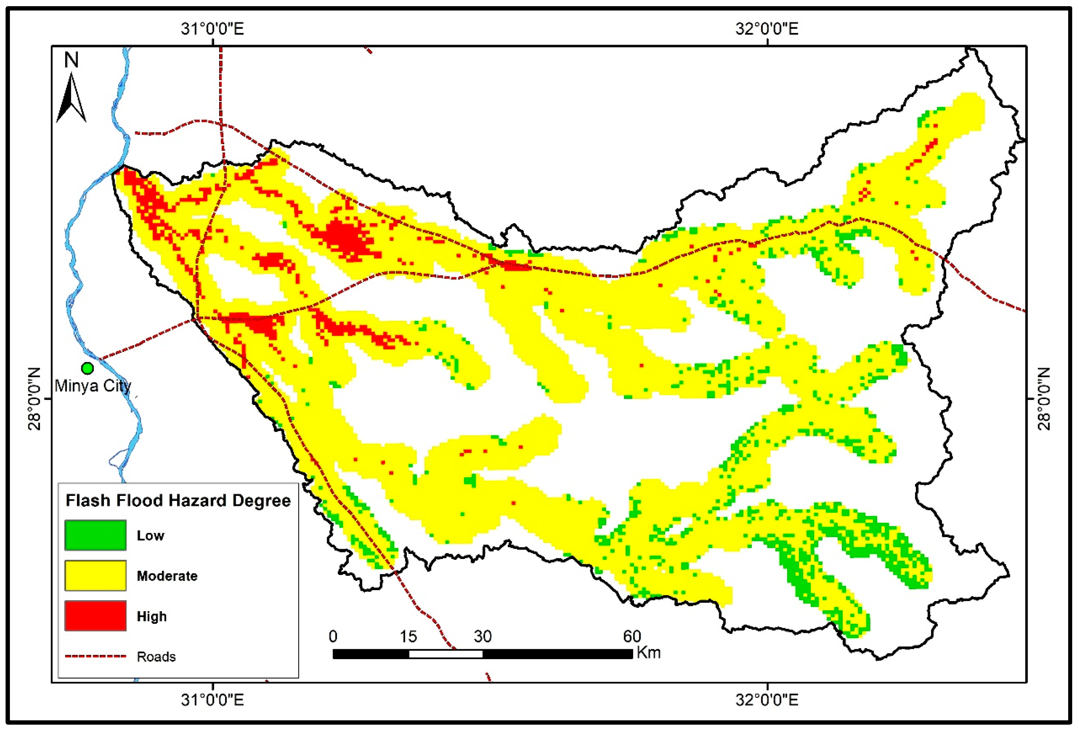
4.9. AHP Weighted Overlay Calculation
5. Conclusions
Funding
Institutional Review Board Statement
Informed Consent Statement
Data Availability Statement
Conflicts of Interest
References
- WMO. World Meteorological Organization: Flash Flood Guidance System (FFGS) with Global Coverage. 2016. Available online: https://community.wmo.int/hydrology-and-water-resources/flash-flood-guidance-system-ffgs-global-coverage (accessed on 27 January 2023).
- El Gohary, R. Environmental Flash Flood Management in Egypt. In Flash Floods in Egypt; Negm, E.E., Ed.; Advances in Science, Technology & Innovation; Springer: New York, NY, USA, 2020; pp. 85–105. [Google Scholar]
- Elnazer, A.A.; Salman, S.A.; Asmoay, A.S. Flash flood hazard affected Ras Gharib city, Red Sea, Egypt: A proposed flash flood channel. Nat. Haz. 2017, 89, 1389–1400. [Google Scholar] [CrossRef]
- El-Saadawy, O.; Gaber, A.; Othman, A.; Abotalib, A.Z.; El Bastawesy, M.; Attwa, M. Modeling Flash Floods and Induced Recharge into Alluvial Aquifers Using Multi-Temporal Remote Sensing and Electrical Resistivity Imaging. Sustainability 2020, 12, 10204. [Google Scholar] [CrossRef]
- Awange, J.; Kiema, J. Fundamentals of GIS. In Environmental Geoinformatics. Environmental Science and Engineering, 2nd ed.; Springer: Cham, Switzerland, 2019; pp. 203–212. [Google Scholar]
- Karymbalis, E.; Andreou, M.; Batzakis, D.-V.; Tsanakas, K.; Karalis, S. Integration of GIS-Based Multicriteria Decision Analysis and Analytic Hierarchy Process for Flood-Hazard Assessment in the Megalo Rema River Catchment (East Attica, Greece). Sustainability 2021, 13, 10232. [Google Scholar] [CrossRef]
- Allafta, H.; Opp, C. GIS-based multi-criteria analysis for flood prone areas mapping in the trans-boundary Shatt Al-Arab basin, Iraq-Iran. Geomat. Nat. Hazards Risk 2021, 12, 2087–2116. [Google Scholar] [CrossRef]
- Malczewski, J. GIS-based multicriteria decision analysis: A survey of the literature. Int. J. Geogr. Inf. Sci. 2006, 20, 703–726. [Google Scholar] [CrossRef]
- Drobne, S.; Lisec, A. Multi-attribute Decision Analysis in GIS: Weighted Linear Combination and Ordered Weighted Averaging. Informatica 2009, 33, 459–474. [Google Scholar]
- Kazakis, N.; Kougias, I.; Patsialis, T. Assessment of flood hazard areas at a regional scale using an index-based approach and Analytical Hierarchy Process: Application in Rhodope-Evros region, Greece. Sci. Total Environ. 2015, 538, 555–563. [Google Scholar] [CrossRef] [PubMed]
- Elsheikh, R.F.A.; Ouerghi, S.; Elhag, A.R. Flood Risk Map Based on GIS, and Multi Criteria Techniques (Case Study Terengganu Malaysia). J. Geogr. Inf. Syst. 2015, 7, 348–357. [Google Scholar] [CrossRef]
- Abdelkarim, A.; Al-Alola, S.S.; Alogayell, H.M.; Mohamed, S.A.; Alkadi, I.I.; Ismail, I.Y. Integration of GIS-Based Multicriteria Decision Analysis and Analytic Hierarchy Process to Assess Flood Hazard on the Al-Shamal Train Pathway in Al-Qurayyat Region, Kingdom of Saudi Arabia. Water 2020, 12, 1702. [Google Scholar] [CrossRef]
- Das, S. Flood susceptibility mapping of the Western Ghat coastal belt using multi-source geospatial data and analytical hierarchy process (AHP). Remote Sens. Appl. Soc. Environ. 2020, 20, 100379. [Google Scholar] [CrossRef]
- Abu El-Magd, S.A.; Amer, R.A.; Embaby, A. Multi-criteria decision-making for the analysis of flash floods: A case study of Awlad Toq-Sherq, Southeast Sohag, Egypt. J. Afr. Earth Sci. 2020, 162, 103709. [Google Scholar] [CrossRef]


| Factors | El | SL | Li | RF | DoR | DD | LC | Sg |
|---|---|---|---|---|---|---|---|---|
| El | 1 | 2 | 1 | 1 | 3 | 7 | 1 | 1 |
| SL | 1/2 | 1 | 2 | 8 | 2 | 6 | 4 | 2 |
| Li | 1 | 1 | 1 | 3 | 3 | 3 | 2 | 3 |
| RF | 1 | 1/8 | 1/3 | 1 | 1 | 2 | 2 | 2 |
| DoR | 1/3 | 1/2 | 1/3 | 1 | 1 | 1 | 2 | 4 |
| DD | 1/7 | 1/6 | 1/3 | 1/2 | 1 | 1 | 3 | 3 |
| LC | 1 | 1/4 | 1/2 | 1/2 | 1/2 | 1/3 | 1 | 3 |
| Sg | 1 | 1 | 1/3 | 1/2 | 1/4 | 1/3 | 0 | 1 |
| Sum | 5.98 | 5.04 | 5.83 | 15.50 | 11.75 | 20.67 | 15.33 | 19.00 |
| Factors | El | SL | Li | RF | DoR | DD | LC | Sg | Sum | Criteria Weight | Criteria Weight % |
|---|---|---|---|---|---|---|---|---|---|---|---|
| El | 0.1673 | 0.3967 | 0.1714 | 0.0645 | 0.2553 | 0.3387 | 0.0652 | 0.0526 | 1.5118 | 0.1680 | 17 |
| SL | 0.0837 | 0.1983 | 0.3429 | 0.5161 | 0.1702 | 0.2903 | 0.2609 | 0.1053 | 1.9677 | 0.2186 | 22 |
| Li | 0.1673 | 0.0992 | 0.1714 | 0.1935 | 0.2553 | 0.1452 | 0.1304 | 0.1579 | 1.3203 | 0.1567 | 16 |
| RF | 0.1673 | 0.0248 | 0.0571 | 0.0645 | 0.0851 | 0.0968 | 0.1304 | 0.1053 | 0.7314 | 0.1013 | 11 |
| DoR | 0.0558 | 0.0992 | 0.0571 | 0.0645 | 0.0851 | 0.0484 | 0.1304 | 0.2105 | 0.7511 | 0.0935 | 10 |
| DD | 0.0239 | 0.0331 | 0.0571 | 0.0323 | 0.0851 | 0.0484 | 0.1957 | 0.1579 | 0.6334 | 0.0804 | 9 |
| LC | 0.1673 | 0.0496 | 0.0857 | 0.0323 | 0.0426 | 0.0161 | 0.0652 | 0.1579 | 0.6167 | 0.0785 | 8 |
| Sg | 0.1673 | 0.0992 | 0.0571 | 0.0323 | 0.0213 | 0.0161 | 0.0217 | 0.0526 | 0.4677 | 0.0620 | 7 |
| Sum | 1.00 | 100 |
Disclaimer/Publisher’s Note: The statements, opinions and data contained in all publications are solely those of the individual author(s) and contributor(s) and not of MDPI and/or the editor(s). MDPI and/or the editor(s) disclaim responsibility for any injury to people or property resulting from any ideas, methods, instructions or products referred to in the content. |
© 2023 by the author. Licensee MDPI, Basel, Switzerland. This article is an open access article distributed under the terms and conditions of the Creative Commons Attribution (CC BY) license (https://creativecommons.org/licenses/by/4.0/).
Share and Cite
Darwish, K. GIS-Based Multi-Criteria Decision Analysis for Flash Flood Hazard and Risk Assessment: A Case Study of the Eastern Minya Watershed, Egypt. Environ. Sci. Proc. 2023, 25, 87. https://doi.org/10.3390/ECWS-7-14315
Darwish K. GIS-Based Multi-Criteria Decision Analysis for Flash Flood Hazard and Risk Assessment: A Case Study of the Eastern Minya Watershed, Egypt. Environmental Sciences Proceedings. 2023; 25(1):87. https://doi.org/10.3390/ECWS-7-14315
Chicago/Turabian StyleDarwish, Kamal. 2023. "GIS-Based Multi-Criteria Decision Analysis for Flash Flood Hazard and Risk Assessment: A Case Study of the Eastern Minya Watershed, Egypt" Environmental Sciences Proceedings 25, no. 1: 87. https://doi.org/10.3390/ECWS-7-14315
APA StyleDarwish, K. (2023). GIS-Based Multi-Criteria Decision Analysis for Flash Flood Hazard and Risk Assessment: A Case Study of the Eastern Minya Watershed, Egypt. Environmental Sciences Proceedings, 25(1), 87. https://doi.org/10.3390/ECWS-7-14315