Next Article in Journal
Prediction of Flooding Area in Batang Sinamar River Basin Based on Design Return Period Simulation by Using Rainfall Runoff Inundation Model
Previous Article in Journal
Estimation of Water Turbidity in Drinking Water Treatment Plants Using Machine Learning Based on Water and Meteorological Data
 
 
Please note that, as of 4 December 2024, Environmental Sciences Proceedings has been renamed to Environmental and Earth Sciences Proceedings and is now published here.
Proceeding Paper

Vulnerability of Small Rivers Coastal Part Due to Floods: The Case Study of Lesvos North—West Coast †

by
Stamatia Papasarafianou
1,*,
Aliki Gkaifyllia
2,
Anna-Eirini Iosifidi
3,
Stavros Sahtouris
2,
Nathalie Wulf
4,
Alexandra Culibrk
2,
Maria-Danai Stamataki
2,
Theodoros Chatzivasileiou
2,
Ilias Siarkos
2,
Celia Rouvenaz
5,
Eleni-Ioanna Koutsovili
2,
Thomas Hasiotis
2 and
Ourania Tzoraki
2
1
Department of Science and Technology, University of Napoli Parthenope, 80143 Napoli, Italy
2
Department of Marine Sciences, University of the Aegean, 80100 Mytilene, Greece
3
Department of Geography, University of the Aegean, 80100 Mytilene, Greece
4
Department of Geography, University of Christian-Albrechts, 24118 Kiel, Germany
5
Department of Civil, Environmental and Geomatic Engineering, University of Environmental Engineering—ETH Zürich, 8092 Zürich, Switzerland
*
Author to whom correspondence should be addressed.
Presented at the 7th International Electronic Conference on Water Sciences, 15–30 March 2023; Available online: https://ecws-7.sciforum.net.
Environ. Sci. Proc. 2023, 25(1), 44; https://doi.org/10.3390/ECWS-7-14257
Published: 16 March 2023
(This article belongs to the Proceedings of The 7th International Electronic Conference on Water Sciences)

Abstract

:
This study presents the development of a vulnerability assessment methodology combining both hydraulic and oceanographic values to evaluate the fragility of the island’s coast, subject to floods. The study area covers the coastal part Petra - Molyvos in North-West Lesvos Island, Greece. Petra stream drains a catchment area of 8.06 km2. The flooded sections of the river’s coastal part are analyzed by the HEC-RAS model, while the coastal vulnerability index (CVI) was calculated by the InVEST model. The scenario of habitats’ role in beach protection showed 53% of coastal protection and the CVI moderate exposure to sandy beaches. A change in the geomorphology of the estuary was observed during the summer period, due to the river sediment dredging and small delta reclamation processes.

1. Introduction

Beaches are critical components of the coastal zone; coastal services contribute around 43% of the total benefits provided by human well-being [1,2]. Beaches provide cultural and ecosystem services, such as food, flood protection, natural environmental conservation, and recreation activities [2,3]. With the increases in multiple human activities, the bio-geological resources are being exploited, polluted, and exposed to stressful uses and pressures, increasing the coastal vulnerability. As a result, coastal erosion is threatening tourist zones and services.
Coastal erosion constitutes a contemporary environmental problem and the projections of coastal retreat under climate change and vulnerability highlight the threat to sustainable growth in the Aegean archipelagos [4,5]. The threat of coastal retreat increases as the rivers’ dammed sediments are arrested in the reservoirs, which has an indirect impact on water storage due to the transportation of sediments by the surface water flow. For example, flash floods can be perceived negatively as they cause (i) damage to farms, and infrastructures, (ii) bank erosion, (iii) and the transport of sediment and coarse material [6,7]. As a large problem that puts the achievement of multiple sustainable development goals of the United Nations at risk, this should be managed through an integrated approach, considering the possibility of sustainable growth [3].
At the same time, the hydrological regimes of Intermittent Rivers and Ephemeral Streams are characterized by flow cessation and dry events at certain periods of the year [6], and ephemeral streams exhibit certain conditions during the hydro-geomorphological processes of runoff generation. Ephemeral streams are more frequent globally, and more than 50% of the river network is intermittent [8]. The Mediterranean strip is the most affected area in general, but in terms of specific regions or areas within countries, different percentages of the river network are affected. Specifically, in France, only 20% of the river network is affected, while in Sardinia and Sicily, 90% of the river network is affected. Additionally, in the southeast of Spain, more than 70% of the fluvial systems are ephemeral streams [9]. The flowing phase enhances sediment transport, while the non-flowing and dry phases facilitate river access and sand and gravel extraction [5].
This paper combines the main results with an analysis of floods after flushy rain episodes and the coastal erosion vulnerability of the sandy and rocky beaches. The aim is to discuss how ephemeral streams could behave to water and sediment balance in a touristic beach, under human and natural pressures. Vulnerability calculation was done using InVEST Coastal Vulnerability index, combining oceanographic and ecological parameters, while HEC-RAS was used to calculate the critical cross-sections in the Petra River.

2. Materials and Methods

2.1. Study Area

The study area covered the coastal part from Petra to Molyvos in west–north Lesvos Island, Greece (Figure 1). The area is characterized by a typical Mediterranean climate with warm and dry summers and cold and wet winters. The mean annual precipitation is 545 mm, and the mean temperature is 17.39 °C. During the winter, the precipitation records showed January, February, and December as the wet months. The main wind directions are north–northeastern, with a maximum intensity of from 4 to 5 bft and 5 to 6 bft. A Petra stream of 1.75 km in length drains a catchment area of 7.97 km2, with a mean width of 6.15 m, a mean slope of 1.03%, and a mean depth of 1.63 m, and flows into the Aegean Sea.

2.2. Coastal Vulnerability Models

The InVEST Coastal Vulnerability model is widely still used to assess coastal erosion, and can provide a framework for regional coastal zone protection and future development planning. To estimate erosion from coastal hazards for people throughout the Petra–Molyvos coastline, we mapped and valued the changes in ecosystems, which could help to convert in the flow, obtaining many different benefits [4]. The model builds on previous, similar indices that account for bio-geophysical components to compare their exposure to erosion and flooding in severe weather [5]. The InVEST CV model produces a qualitative index of coastal exposure to erosion, as well as summaries of human population density in proximity to the coastline. The exposure of erosion in the study area is defined by calculating the coastal vulnerability index (CVI), which ranks sites from lowest exposure (rank = 1) to highest risk of erosion (rank = 5) and inundation using the following variables: habitat type, the local bathymetry and topography, the relative wind and wave force associated with storms, and the population density (Equation (1)).
CVI = (RHabitatsRShorline TypeRReliefRWavesRSurge)1/5

2.3. HEC-RAS Model

The software (version 6.3.1) Engineers River Analysis System (HEC-RAS) developed by the Hydrologic Engineering Center allows for users to model rivers flowing through open natural channels and is used to compute water surface profiles [10]. The HEC-RAS system can simulate one-dimensional, steady-flow, water-surface profile computations and uses geometric and hydraulic computation routines. The river geometries, such as centerlines, bank lines, flow paths, and cross-sectional lines, are the major parameters processed in HEC-RAS to generate flood-prone areas [10].

3. Results

The Aegean Archipelago climate, water masses’ movement, and geomorphology have developed a strong ecological and human resilience to degradation. However, both environmental and anthropogenic changes are threatening the precarious balance between water resources and flood risk [7].

3.1. Coastal Vulnerability

Natural activities play a significant role in coastal vulnerability. The Aegean circulation ends with a northern flow in the eastern basin. The passage between Asia Minor, Chios, and Lesvos has more kinetic energy than the rest of the eastern basin (low kinetic energy) due to the 200 m isobath, which turns to the east. Additionally, the currents near Petra have low kinetic energy [11]. The complex physiography of the Aegean archipelago influences the wind, in addition to the wave climate. In general, wind and waves occur because of the short fetches and relatively mild duration [2]. The wind and waves on the Northern Aegean coastlines are mostly northern in direction, and as a result, they occur frequently on the Petra-Molyvos coastline. Although waves are generally more energetic in the winter season, even in the summer, energetic waves can be found the Aegean Sea and in Petra, which are mainly forced by the strong, dry N–NE ‘etesian’ winds [12,13].
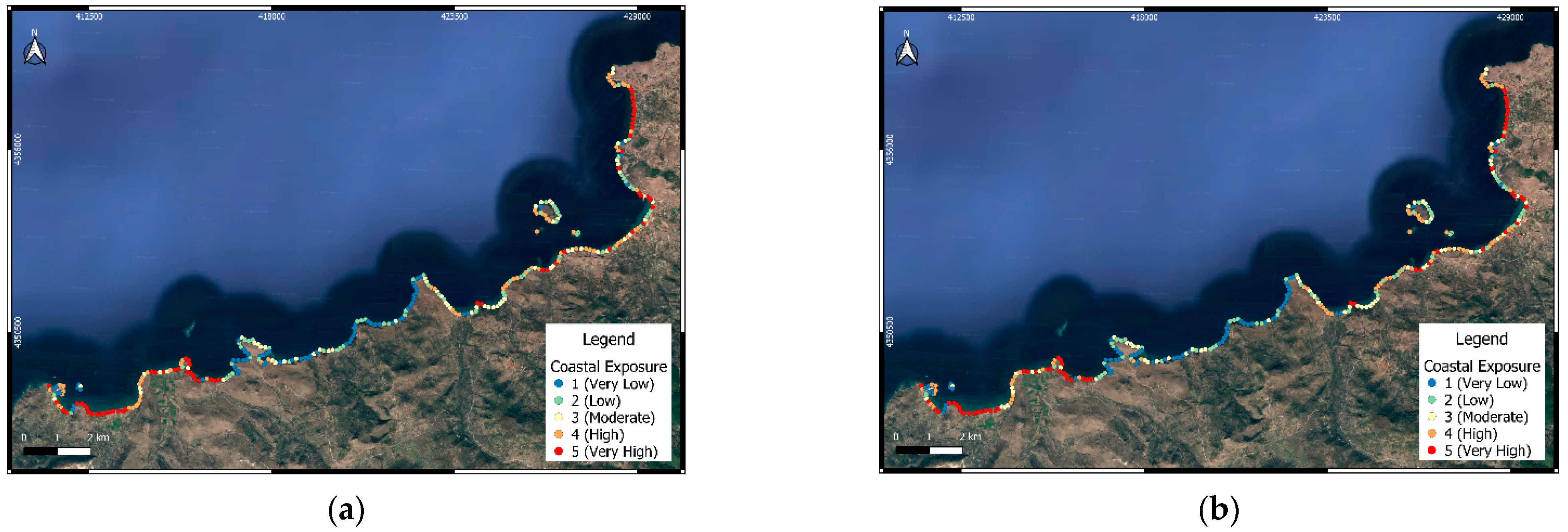
The results of the InVEST Coastal Vulnerability model showed that the main exposed areas of erosion are sandy beaches. The two vulnerability scenarios—with habitats (Figure 2a) and without habitats (Figure 2b)—showed the importance of habitats in beach protection. A total of 13% of the coastal zone showed a high risk of erosion (rank = 4–5) and 21% of the coastal zone had moderate risk (rank = 3) for the scenario without habitats. The vulnerability scenario with habitats obtained a score of 53% for coastal protection, and the CV index showed moderate risk (rank = 2–3). Additionally, the results from the CV index showed low exposure (rank = 1–2) to rock beaches and high exposure (rank = 4–5) to sandy beaches (Figure 3).

3.2. Hydraulic Study

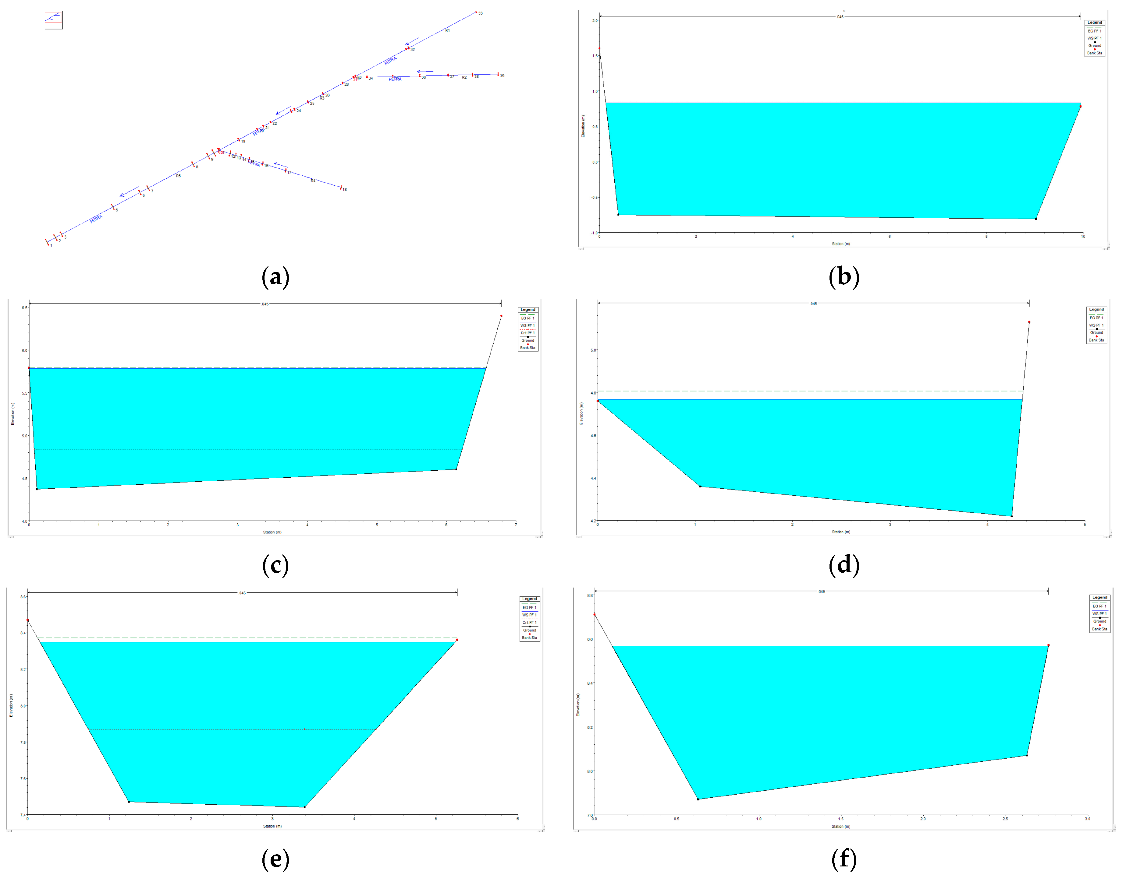
The Froude value at the location R5 (Table 1) of the cross-section S2 is 0.15 and is characterized as subcritical. This cross-section is located 17 m upstream (Figure 4a,b) the mouth of the stream towards the sea. It presents the lowest velocity and energy line slope values in the branch (v = 0.57 m/s, slope = 0.0005 m/m), and the mean velocity of 1.33 m/s. The Froude value at the cross-section S18 location is 0.14 (Figure 4a,c) and is characterized as subcritical. The S18 has the smallest geometry in the branch. The velocity and slope values of the energy line are also small (v = 0.48 m/s, slope = 0.0005 m/m), and the branch average velocity is 1.10 m/s. The Froude value at the cross-section S26 location is 0.44 (Figure 4a,c) and is characterized as subcritical. The S26 geometry is the second smallest for the branch. The power line velocity and gradient values are low throughout the branch, with the cross-section values of v = 0.87 m/s, slope = 0.0059 m/m, and the branch average velocity is 0.90 m/s. Upstream of the cross-section, there is a hydraulic jump where the flow changes from supercritical to subcritical. The Froude value at the cross-section S32 location is 0.27 (Figure 4a,e), and the velocity and slope of the energy line are significantly lower than all other cross-sections (v = 0.66 m/s, slope = 0.001856 m/m). The wetted surface is the largest present in branch R1, while the branch average velocity is equal to 1.42 m/s. Finally, the Froude value at the cross-section S37 location is 0.43 (Figure 4a,f) and is characterized as subcritical. The velocity and slope of the energy line are the third smallest (v = 0.99 m/s, slope = 0.006421 m/m). The cross-section shows the second smallest geometry, and the branch average velocity is equal to 1.25 m/s. The simulation results show that, under flashy rain events, several cross-sections of the stream are overflooded.

4. Conclusions

The paper analyses the importance of rivers in the sediment transport balance in the coastal zone of Molyvos-Petra. It discusses the factors affecting coastal streams after flashy rain episodes and the vulnerability of the sandy and rocky beaches. Concluding, how ephemeral streams could behave to sediment balance in a touristic beach, under human and natural activities.
Multiple indicators are used to evaluate the vulnerability of each coastline. According to the results, the habitat is an important part of the coastal zone, and its influence on coastal exposure plays a significant role. All kinds of habitats, whether along the coastline or in the water, have protective effects on the coast [14]. Further, if the coastline is composed of many rocks, low in exposure and high in relief, it can reduce the erosion of waves on the coast. However, the coastline composed of sandy beaches, which are high in exposure and low in relief, has little effect on reducing the impact of wind and waves [14].
Moreover, the hydraulic analysis of the Petra River, during the rainy events showed low velocities in geometrically small cross-sections. People should pay more attention to some impacts, such as storm surges, floods, coastal erosion, and other natural disasters that endanger the economy, life, property safety, and the ecological environment around the coastal zone when people focus on the development of the coastal zone [14].

Author Contributions

Conceptualization, T.H. and O.T.; methodology, S.P.; software, A.-E.I., S.S., T.C., C.R. and I.S.; validation, T.H. and O.T.; formal analysis, A.-E.I., S.S., T.C., A.G. and I.S.; resources, S.P.; data curation, A.-E.I., S.S., A.G., N.W., C.R., A.C., E.-I.K., M.-D.S. and S.P.; writing—original draft preparation, S.P.; writing—review and editing, S.P.; visualization, O.T.; supervision, O.T.; project administration, T.H.; funding acquisition, T.H. and O.T. All authors have read and agreed to the published version of the manuscript.

Funding

This research was funded by Partner, INTERREG Greece–Cyprus, Coastal erosion due to climate change: assessment and ways of effective treatment in tourist areas of the North Aegean and Cyprus.

Institutional Review Board Statement

Not applicable.

Informed Consent Statement

Not applicable.

Data Availability Statement

Not applicable.

Acknowledgments

The authors thank Hasiotis T., Tzoraki O. and Sahtouri S. for their assistance with the operating costs of the present research, which were partly funded by Partner, INTERREG Greece–Cyprus, Coastal erosion due to climate change: assessment and ways of effective treatment in tourist areas of the North Aegean and Cyprus. Koutsovili E.I., Stamataki M.D., Culibrk A., and Chatzivasileiou T. for funded by the Operational Program National Strategic Reference Framework (NSRF) North Aegean 2014-2020, AEGIS+. Papasarafianou S. is funded by the Ph.D. program Phenomena and Environmental Risk by the University of Naples, Parthenope, and Wulf N. This research is part of ERASMUS Plus.

Conflicts of Interest

The authors declare no conflict of interest.

References

  1. Levrel, H.; Cabral, P.; Marcone, O.; Mongruel, R. The services provided by marine ecosystems. In Value and Economy of Marine Resources; John Wiley & Sons Inc.: Hoboken, NJ, USA, 2014; pp. 1–51. [Google Scholar]
  2. Monioudi, I.N.; Velegrakis, A.F.; Chatzipavlis, A.E.; Rigos, A.; Karambas, T.; Vousdoukas, M.I.; Hasiotis, T.; Koukourouvli, N.; Peduzzi, P.; Manoutsoglou, E.; et al. Assessment of island beach erosion due to sea level rise: The case of the Aegean archipelago (Eastern Mediterranean). Nat. Hazards Earth Syst. Sci. 2017, 17, 449–466. [Google Scholar] [CrossRef]
  3. Caroa, C.; Marquesa, J.C.; Cunhac, P.; Teixeiraa, Z. Ecosystem services as a resilience descriptor in habitat risk assessment using the InVEST model. Ecol. Indic. 2020, 115, 106426. [Google Scholar] [CrossRef]
  4. Sharp, R.; Tallis, H.T.; Ricketts, T.; Guerry, A.D.; Wood, S.A.; Chaplin-Kramer, R.; Nelson, E.; Ennaanay, D.; Wolny, S.; Olwero, N.; et al. InVEST + VERSION + User’s Guide; Stanford University: Stanford, CA, USA, 2018. [Google Scholar]
  5. Hammar-Klose, E.S.; Thieler, E.R. Coastal Vulnerability to Sea-Level Rise: A Preliminary Database for the U.S. Atlantic, Pacific, and Gulf of Mexico Coasts; U.S. Geological Survey: Reston, VA, USA, 2001. [Google Scholar]
  6. Pastor, A.V.; Tzoraki, O.; Bruno, D.; Kaletova, T.; Mendoza-Lera, C.; Alamanosi, A.; Brummer, M.; Datry, T.; De Girolamo, A.M.; Jakubínský, J.; et al. Rethinking ecosystem service indicators for their application to intermittent rivers. Ecol. Indic. 2022, 137, 108693. [Google Scholar] [CrossRef]
  7. Stubbington, R.; Acreman, M.; Acuna, V.; Boon, P.J.; Boulton, A.J.; England, J.; Gilvear, D.; Sykes, T.; Wood, P.J. Ecosystem services of temporary streams differ between wet and dry phases in regions with contrasting climates and economies. People Nat. 2020, 2, 660–677. [Google Scholar] [CrossRef]
  8. Skoulikidis, N.T.; Sabater, S.; Datry, T.; Morais, M.M.; Buffagni, A.; Dörflinger, G.; Zoogaris, S.; Sánchez Montoya, M.M.; Bonada, N.; Kalogianni, E.; et al. Non-perennial Mediterranean rivers in Europe: Status, pressures, and challenges for research and management. Sci. Total Environ. 2017, 577, 1–8. [Google Scholar] [CrossRef]
  9. Camarasa-Belmonte, A.M. Flash-Flooding of ephemeral streams in the context of climate change. Geogr. Res. Lett. 2021, 47, 121–142. [Google Scholar] [CrossRef]
  10. Tamiru, H.; Dinka, M.O. Application of ANN and HEC-RAS model for flood inundation mapping in lower Baro Akobo River Basin, Ethiopia. J. Hydrol. Reg. Stud. 2021, 36, 100855. [Google Scholar] [CrossRef]
  11. Olson, D.B.; Kourafalou, V.H.; Johns, W.E.; Samuels, G.; Veneziani, M. Aegean Surface Circulation from a Satellite-Tracked Drifter Array. J. Phys. Oceanogr. 2007, 37, 1898–1917. [Google Scholar] [CrossRef]
  12. Androulidakis, Y.; Kombiadou, K.; Makris, C.; Baltikas, V.; Krestenitis, Y.N. Storm surges in the Mediterranean Sea: Variability and trends under future climatic conditions. Dyn. Atmos. Ocean. 2015, 71, 56–82. [Google Scholar] [CrossRef]
  13. Soukissian, T.; Hatzinaki, M.; Korres, G.; Papadopoulos, A.; Kallos, G.; Anadranistakis, E. Wind and wave atlas of the Hellenic seas; Hellenic Centre for Marine Research Publications: Attiki, Greece, 2007. [Google Scholar]
  14. Ai, B.; Tian, Y.; Wang, P.; Gan, Y.; Luo, F.; Shi, Q. Vulnerability Analysis of Coastal Zone Based on InVEST Model in Jiaozhou Bay, China. Sustainability 2022, 14, 6913. [Google Scholar] [CrossRef]
Figure 1. Petra catchment: The basin was divided into 5 subbasins to analyze the mainstream Petra River.
Environsciproc 25 00044 g001
Figure 2. Map of Petra–Molyvos’ exposure to erosion (a) with the habitats variable and (b) without the habitats variable.
Environsciproc 25 00044 g002
Figure 3. Histogram with a frequency of the occurrence of observed coastal vulnerability index values.
Environsciproc 25 00044 g003
Figure 4. The critical cross-section and the stream plot: (a) the Petra stream (b) S2, (c) S18, (d) S26, (e) S32, and (f) S37.
Environsciproc 25 00044 g004
Table 1. Stream of Petra’s hydraulic characteristics.
Stream of Petra
ReachSubbasin Area (km2)Subbasin
Δη (m)
Reach Length (m)Q
(m3/s)
Overflow Section
R12.065603752.15S32
R20.874853171.40S37
R30.14153991.55S26
R44.653452583.90S18
R50.201453678.50S2
Disclaimer/Publisher’s Note: The statements, opinions and data contained in all publications are solely those of the individual author(s) and contributor(s) and not of MDPI and/or the editor(s). MDPI and/or the editor(s) disclaim responsibility for any injury to people or property resulting from any ideas, methods, instructions or products referred to in the content.