Next Article in Journal
Integration of Precision Agriculture Techniques for Pest Management
Previous Article in Journal
Role of Nanotechnology in Precision Agriculture
 
 
Please note that, as of 4 December 2024, Environmental Sciences Proceedings has been renamed to Environmental and Earth Sciences Proceedings and is now published here.
Proceeding Paper

Spatio-Temporal Assessment of Satellite-Based Precipitation Products for Hydroclimatic Applications over Potohar Region, Pakistan †

by
Muhammad Umer Nadeem
1,2,3,
Muhammad Naveed Anjum
1,2,*,
Muhammad Asif
3,
Tahir Iqbal
2,
Saddam Hussain
4,5,
Hafiz Rana Azeem Sarwar
3 and
Akhtar Abbas
3
1
Department of Land and Water Conservation Engineering, Faculty of Agricultural Engineering and Technology, PMAS-Arid Agriculture University, Rawalpindi 46000, Pakistan
2
Data Driven Smart Decision Platform, PMAS-Arid Agriculture University, Rawalpindi 46000, Pakistan
3
Climate, Energy and Water Resources Institute, National Agriculture Research Center, Islamabad 44000, Pakistan
4
Department of Irrigation and Drainage, University of Agriculture Faisalabad, Faisalabad 38000, Pakistan
5
Department of Agricultural and Biological Engineering, University of California (UC Davis), Davis, CA 95616, USA
*
Author to whom correspondence should be addressed.
Presented at the 1st International Precision Agriculture Pakistan Conference 2022 (PAPC 2022)—Change the Culture of Agriculture, Rawalpindi, Pakistan, 22–24 September 2022.
Environ. Sci. Proc. 2022, 23(1), 18; https://doi.org/10.3390/environsciproc2022023018
Published: 26 December 2022

Abstract

:
Reliable precipitation data at appropriate resolutions are essential for crop irrigation scheduling, climate change assessments, and mitigating floods and droughts. However, information on precipitation at acceptable spatial and temporal scales is lacking in Pakistan, particularly in undulating areas such as the Potohar region. Therefore, an investigation was conducted to check the accuracies of two satellite-based precipitation products (SPPs), PERSIANN-CDR and TRMM, concerning the gauge-based data obtained from the Pakistan Metrological Department (PMD). At the pixel and regional scales, the uncertainty in satellite-based daily, monthly, and annual precipitation estimates was investigated. Statistical indices were used for the spatio-temporal assessment of SPPs. The results reveal that both SPPs performed better on the monthly and daily scales. The TRMM precipitation product was in better agreement with in situ gauge-based data (with CC > 0.7). Therefore, we recommend using TRMM data for hydro-climatic applications in the Potohar region of Pakistan.

1. Introduction

Monitoring precipitation data are crucial for making decisions regarding agricultural irrigation, the design of hydrological structures, and the provision of drinking water to urban and rural areas. Precipitation is considered a significant source of water used in rainfed agriculture. It is also one of the key climatic factors in Pakistan’s socio-economic development, hydropower generation, development of hydrological structures (small/mini dams), rainwater harvesting, flood monitoring, and many other essential activities [1]. Pakistan’s economy is said to be based on agriculture, which heavily relies on water. A little over 40% of the annual budget is allocated to agriculture, although dryland farming still receives little attention. Approximately 95% of stored water is used in many agricultural activities [2]. It is also a plentiful resource for the nation’s health and growth, which has been under massive strain due to the fast-growing population over the past 60 years [2,3,4]. Therefore, it is essential to explore different sources of rainfall data. Radars and in situ metrological stations are commonly considered the most trusted sources for many applications [5], and Pakistan Metrological Department provides gauge information. According to the literature, one gauging station can accurately cover an area of about 36 km2 [5,6]. A similar gauge pattern was observed in the Potohar region, indicating the poor presentation of data. Therefore, we must explore different sources of precipitation data.
Rainfed agriculture depends on rainwater and its conservation, so this study is more crucial in the rainfed Potohar area. The accuracy of SPPs depends on the local terrain and meteorological system, although they can provide continuous information about global precipitation at precise spatial and temporal resolutions [5,6,7]. Therefore, it is essential to assess the reliability of SPPs before directly applying them to various hydrological applications. Most contemporary SPPs use extensive precipitation estimation techniques to predict precipitation estimates. These techniques can offer reliable data at fine spatio-temporal scales, employing signals from infrared (IR) and microwave (MW) sensors [8,9,10,11].
In recent years, many SPPs have been evaluated in the mountainous ranges of Pakistan [2,3,4,5]. However, the spatial and temporal analysis of the two latest SPPs, including PERSIANN-CDR and TRMM, in the Potohar region of Pakistan, has not yet been evaluated. Therefore, the primary goal of this analysis is to assess satellite precipitation products (PERSIANN-CDR and TRMM) over the Potohar region of Pakistan. The issue of discontinuous precipitation data is anticipated to be solved by SPPs. Two recent SPPs (TRMM and CDR) over Pakistan’s Potohar region will be assessed for the first time in terms of spatial and temporal resolutions. The conclusions of this research will be highly beneficial to Pakistani policymakers, hydrologists, meteorologists, water conservation measures, and users of SPPs data.

2. Materials and Methods

The Potohar region is situated between the Indus River and the Jhelum River at 33°30′0″ N and 73°0′0″ E and stretches from the salt range northward to the foothills of the Himalayas. Four districts—Attock, Jhelum, and Rawalpindi, and Chakwal— make up the Potohar region. Figure 1 depicts the study area’s Digital Elevation Model (DEM) and available meteorological stations.
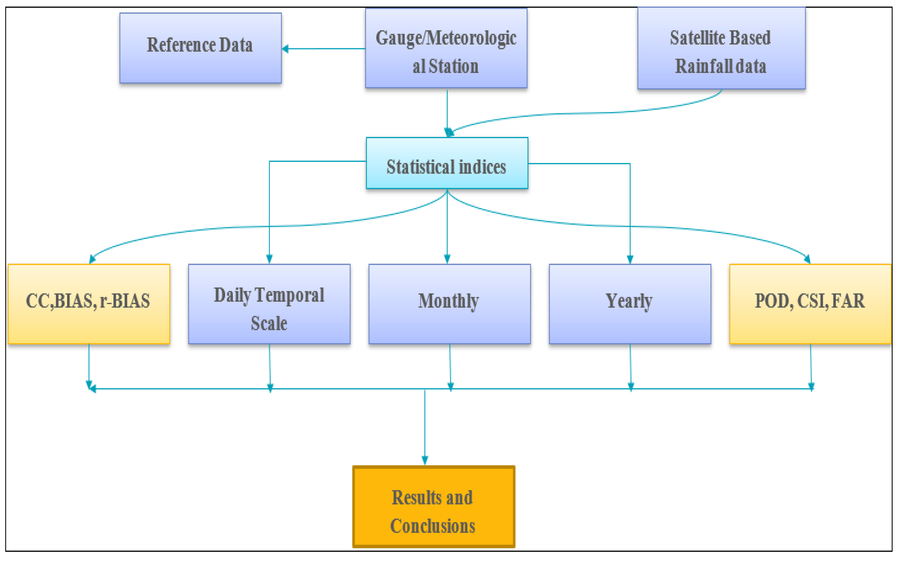
The spatial and temporal assessment of PERSIANN-CDR and TRMM precipitation is performed by adopting the methodology of a flow chart (Figure 2).

3. Results and Conclusions

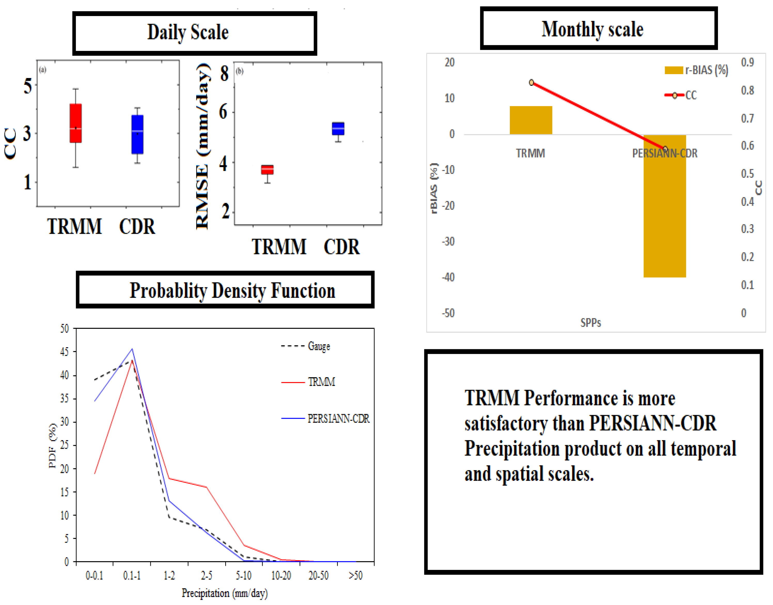
The spatial-temporal assessment analysis of PERSIANN-CDR and TRMM was conducted at a point-to-pixel scale over the Potohar region [5,6]. All SPPs were evaluated between 2017 and 2020. The main results of our study are illustrated in Figure 3.
  • On a daily scale, the performance of TRMM is more satisfactory than PERSIANN-CDR.
  • On a monthly scale, the precipitation estimates of both SPPs (TRMM and PERSIANN-CDR) are in good contact with gauge data.
  • The daily PERSIANN-CDR performance is unsatisfactory (CC < 0.7). However, its monthly CC value (CC = 0.83) is acceptable.
  • The error value RMSE is also the maximum for PERSIANN-CDR compared to TRMM.
  • The TRMM outperforms the PERSIANN product based on a yearly scale.
  • The POD and FAR are close to 1 for TRMM, but the PERSIANN-CDR values are not in acceptable ranges.
  • PERSIANN-CDR has a higher false alarm ratio (FAR) than TRMM.
On daily, monthly, and annual scales, the CC values of the TRMM product are greater than 0.7, and its rBIAS and RMSE are in acceptable ranges. Therefore, we recommend using the TRMM product for hydroclimate applications over the Potohar region of Pakistan.

Author Contributions

All authors equally contributed to this article. All authors have read and agreed to the published version of the manuscript.

Funding

This study receive no external funding.

Institutional Review Board Statement

Not applicable.

Informed Consent Statement

Not applicable.

Data Availability Statement

Not applicable.

Conflicts of Interest

The authors declare no conflict of interest.

References

  1. Anjum, M.N.; Irfan, M.; Waseem, M.; Leta, M.K.; Niazi, U.M.; Rahman, S.; Ghanim, A.; Mukhtar, M.A.; Nadeem, M.U. Assessment of PERSIANN-CCS, PERSIANN-CDR, SM2RAIN-ASCAT, and CHIRPS-2.0 Rainfall Products over a Semi-Arid Subtropical Climatic Region. Water 2022, 14, 147. [Google Scholar] [CrossRef]
  2. FAO (Food and Agriculture Organisation of the United Nations). AQUASTAT. 2021. Available online: https://www.fao.org/aquastat (accessed on 3 September 2021).
  3. Ashraf, M. Water Scarcity in Pakistan: Issues and Options. 2018. Available online: http://pcrwr.gov.pk/wp-content/uploads/2021/07/Water-Scarcity-in-Pakistan-Issues-and-Options-May-18.pdf (accessed on 16 August 2021).
  4. Nadeem, M.U.; Waheed, Z.; Ghaffar, A.M.; Javaid, M.M.; Hamza, A.; Ayub, Z.; Nawaz, M.A.; Waseem, W.; Hameed, M.F.; Zeeshan, A.; et al. Application of HEC-HMS for flood forecasting in Hazara catchment Pakistan, south Asia. Int. J. Hydrol. 2022, 6, 7–12. [Google Scholar] [CrossRef]
  5. Nadeem, M.U.; Anjum, M.N.; Afzal, A.; Azam, M.; Hussain, F.; Usman, M.; Javaid, M.M.; Mukhtar, M.A.; Majeed, F. Assessment of Multi-Satellite Precipitation Products over the Himalayan Mountains of Pakistan, South Asia. Sustainability 2022, 14, 8490. [Google Scholar] [CrossRef]
  6. Nadeem, M.U.; Ghanim, A.A.J.; Anjum, M.N.; Shangguan, D.; Rasool, G.; Irfan, M.; Niazi, U.M.; Hassan, S. Multiscale Ground Validation of Satellite and Reanalysis Precipitation Products over Diverse Climatic and Topographic Conditions. Remote Sens. 2022, 14, 4680. [Google Scholar] [CrossRef]
  7. Ali, A.F.; Xiao, C.; Anjum, M.N.; Adnan, M.; Nawaz, Z.; Ijaz, M.W.; Sajid, M.; Farid, H.U. Evaluation and comparison of TRMM multi-satellite precipitation products with reference to rain gauge observations in Hunza River basin, Karakoram Range, northern Pakistan. Sustainability 2017, 9, 1954. [Google Scholar] [CrossRef] [Green Version]
  8. Nadeem, M.U.; Rasool, G.; Nawaz, M.A. Runoff Estimations by Using Satellite-Based Rainfall Products (Srps) and Then, Identifying Its Relation with Other Gauge Data Over Potohar Plateau, Pakistan. Int. J. Water Res. 2022, 4, 126. [Google Scholar] [CrossRef]
  9. Amorim, J.d.S.; Viola, M.R.; Junqueira, R.; de Oliveira, V.A.; de Mello, C.R. Evaluation of satellite precipitation products for hydrological modeling in the Brazilian cerrado biome. Water 2020, 12, 2571. [Google Scholar] [CrossRef]
  10. Tahir, A.A.; Chevallier, P.; Arnaud, Y.; Ahmad, B. Snow cover dynamics and hydrological regime of the Hunza River basin, Karakoram Range, Northern Pakistan. Hydrol. Earth Syst. Sci. 2011, 15, 2275–2290. [Google Scholar] [CrossRef] [Green Version]
  11. Yang, M.; Li, Z.; Anjum, M.N.; Gao, Y. Performance evaluation of version 5 (V05) of Integrated Multi-satellite Retrievals for Global Precipitation Measurement (IMERG) over the Tianshan Mountains of China. Water 2019, 11, 1139. [Google Scholar] [CrossRef]
Figure 1. Metrological stations and digital elevation model of the study area.
Environsciproc 23 00018 g001
Figure 2. Layout of study.
Environsciproc 23 00018 g002
Figure 3. Results of TRMM and PERSIANN-CDR on different temporal and spatial scales.
Environsciproc 23 00018 g003
Disclaimer/Publisher’s Note: The statements, opinions and data contained in all publications are solely those of the individual author(s) and contributor(s) and not of MDPI and/or the editor(s). MDPI and/or the editor(s) disclaim responsibility for any injury to people or property resulting from any ideas, methods, instructions or products referred to in the content.