Estimating the probability of wildfire occurrence in certain areas, under particular environmental and anthropogenic conditions, is a powerful tool to support forest protection and management plans. In this context, the implementation of Wildfire Susceptibility Maps (WSM) and the investigation of the main driving factors (e.g., land cover class, type of vegetation, topography) are fundamental.
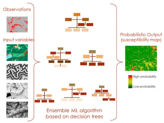
Susceptibility maps indicate areas with the potential to experience a particular hazard in the future based on the intrinsic local properties of a site, as well as the observed past events. Machine Learning (ML) based approaches lend themselves well to this purpose. ML is essentially based on algorithms capable of learning from and making predictions on data by modelling the hidden/non-linear relationships between a set of input variables (driving factors) and output observations (Figure 1).

Figure 1.
Susceptibility wildfire mapping process based on an ensemble of single decision trees.
In the present work, we discuss three case studies for WSM dealing with (i) areas mapped at different scales, and (ii) characterized by a different degree of accuracy/quality of the input datasets. They consist of: (1) comparison between deterministic methods (assuming a priori knowledge of driving factors) versus stochastic approaches (based on artificial neural network and decision trees) for WSM in Dão-Lafões region (Portugal) [1]; (2) implementation of an ensemble ML algorithm based on decision trees (Random Forest) for WSM in Liguria Region (Italy) [2]; and (3) in Santa Cruz (Bolivia) [3].
The first case study emphasizes the advantage of using ML compared to deterministic/linear methods. The second introduces a well-structured and easily replicable application of Random Forest for WSM, including model validation (avoiding spatial autocorrelation and overfitting) and the use of categorical variables. Finally, the third case study successfully demonstrates that it is possible to implement a simple, but powerful, model even for a country such as Bolivia, with poor resources in terms of data availability and informatisation.
Author Contributions
Conceptualization, M.G.P. and M.T.; methodology, M.T.; software, M.T.; validation, M.T. and P.F.; formal analysis, M.T.; investigation, M.T.; resources, P.F.; data curation, M.T.; writing—original draft preparation, M.T.; writing—review and editing, M.T., M.G.P. and P.F.; visualization, M.T.; supervision, P.F.; project administration, P.F. and M.G.P.; funding acquisition, P.F. and M.G.P. All authors have read and agreed to the published version of the manuscript.
Funding
This research received no external funding.
Institutional Review Board Statement
Not applicable.
Informed Consent Statement
Not applicable.
Data Availability Statement
The datasets generated and analyzed during the current study are available from the corresponding author on a reasonable request.
Conflicts of Interest
The authors declare no conflict of interest. The founders had no role in the design of the study; in the collection, analyses or interpretation of data; in the writing of the manuscript, or in the decision to publish the results.
References
- Leuenberger, M.; Parente, J.; Tonini, M.; Pereira, M.G.; Kanevski, M. Wildfire susceptibility mapping: Deterministic vs. stochastic approaches. Environ. Model. Softw. 2018, 101, 194–203. [Google Scholar] [CrossRef]
- Tonini, M.; D’andrea, M.; Biondi, G.; Esposti, S.; Trucchia, A.; Fiorucci, P. A Machine Learning-Based Approach for Wildfire Susceptibility Mapping. The Case Study of the Liguria Region in Italy. Geosciences 2020, 10, 105. [Google Scholar] [CrossRef] [Green Version]
- Bustillo Sánchez, M.; Tonini, M.; Mapelli, A.; Fiorucci, P. Spatial Assessment of Wildfires Susceptibility in Santa Cruz (Bolivia) Using Random Forest. Geosciences 2021, 11, 224. [Google Scholar] [CrossRef]
Publisher’s Note: MDPI stays neutral with regard to jurisdictional claims in published maps and institutional affiliations. |
© 2022 by the authors. Licensee MDPI, Basel, Switzerland. This article is an open access article distributed under the terms and conditions of the Creative Commons Attribution (CC BY) license (https://creativecommons.org/licenses/by/4.0/).