Next Article in Journal
The Emergence of a Governance Landscape for Saline Agriculture in Europe, the Middle East and North Africa
Previous Article in Journal
Drought Stress Responses of Four Contrasting Provenances of Argania spinosa
 
 
Please note that, as of 4 December 2024, Environmental Sciences Proceedings has been renamed to Environmental and Earth Sciences Proceedings and is now published here.
Proceeding Paper

Spatial Variability of Soil Salinity: The Case of Beni Amir in the Tadla Plain of Morocco †

1
Laboratory Mediterranean Environment and Agro-Hydrosystem Modelling (UMR 1114 EMMAH), Hydrogeology Department, Avignon University, 84000 Avignon, France
2
Laboratory of Applied and Marine Geosciences, Geotechnics and Geohazards (LR3G), Faculty of Sciences (FS), University Abdelmalek Essaadi, Tetouan 93000, Morocco
3
National Institute of Agricultural Research (INRA), CRRAR, URECRN, Rabat 10000, Morocco
4
Faculté des Sciences et Techniques (FSTBM), Sultan Moulay Slimane University, BP 523, Beni Mellal 23000, Morocco
*
Author to whom correspondence should be addressed.
Presented at the 2nd International Laayoune Forum on Biosaline Agriculture, 14–16 June 2022; Available online: https://lafoba2.sciforum.net/.
Environ. Sci. Proc. 2022, 16(1), 9; https://doi.org/10.3390/environsciproc202201609
Published: 16 June 2022
(This article belongs to the Proceedings of The 2nd International Laayoune Forum on Biosaline Agriculture)

Abstract

:
The control of soil salinity and the achievement of sustainable agricultural development goals require knowledge of the soil salinity spatial distribution and its temporal evolution. The objective of this study was to understand the spatial variations of soil salinity in the geomorphologic zone in Beni Amir, Tadla region of Morocco. Electromagnetic induction was used to measure the apparent electrical conductivity (ECa) of the soil. The results showed that the distribution of ECa varies across the distance from the drain, and suggests the movement of salts from upstream to downstream. The vertical-horizontal electromagnetic readings show that the saline profile is descending. This study shows that the spatial variability of salinity in a geomorphological site is related to the position in the landscape.

1. Introduction

The irrigated perimeter of Tadla, located in the center of Morocco, is among the oldest and most important agricultural production regions in the country. The region includes a 300,000-ha agricultural area of which 124,600 ha is irrigated [1,2]. The study region Beni Amir is an irrigated sub-perimeter of Tadla. It irrigates with the waters from Oued Oum Er Rbia, which contains 1 g/L of salt in the groundwater. The practice of irrigation using poor-quality (high-salinity) water coupled with non-maintenance of drainage canals leads to the deterioration of soil and groundwater salinization [3,4]. These unsustainable practices impact agricultural productivity and hence lead to land abandonment and desertification.
Several studies have been conducted to minimize soil salinization in the irrigated perimeter of Tadla. Some have improved knowledge of the nature of degradation mechanisms [3]. Previously, a few soil salinity mapping works have been conducted. Some of them used many measurements, but on a small area; others tried to draw a salinity map of Tadla [5,6], but with a number of weak measures. The aim of this study was to understand the mechanisms for spatial variations of soil salinity in natural areas as affected by geomorphology via the use of a geophysical method.

2. Materials and Methods

2.1. Study Site

The study region Beni Amir lies under the irrigated perimeter of the Tadla plain (Figure 1). It irrigates using the saline waters from Oum Er Rbia River, which contains salinity of 2.25 dS/m. The overall salinity of the soil in the study region varies between 0.35 and 13 dS/m [4].
The study region has regular topography with an altitude of 400 m. Its latitude ranges from 32.06 to 32.56 and its longitude ranges from −7.09 to −6.24. The climate of the study site is Mediterranean type arid to semi-arid with a continental character marked by a cold and humid winter and a hot and dry summer and annual precipitation of 350 mm, irregularly distributed. The summer season is characterized by the absence of precipitation with the exception of rare brutal showers. Temperatures vary greatly seasonally. Winter minimum temperature ranges from 0 °C to 5 °C, while the summer maximums range from 38 °C to 42 °C. The average annual evaporation is 1796 mm and varies between 1500 mm and 2000 mm.

2.2. Data Collection

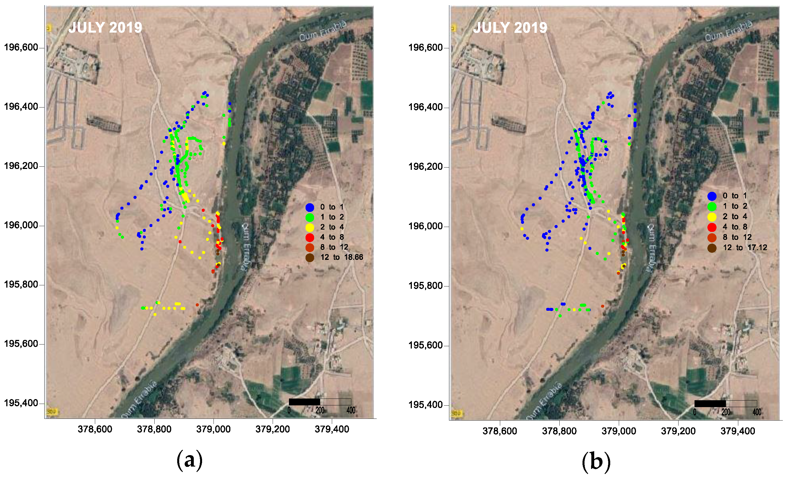
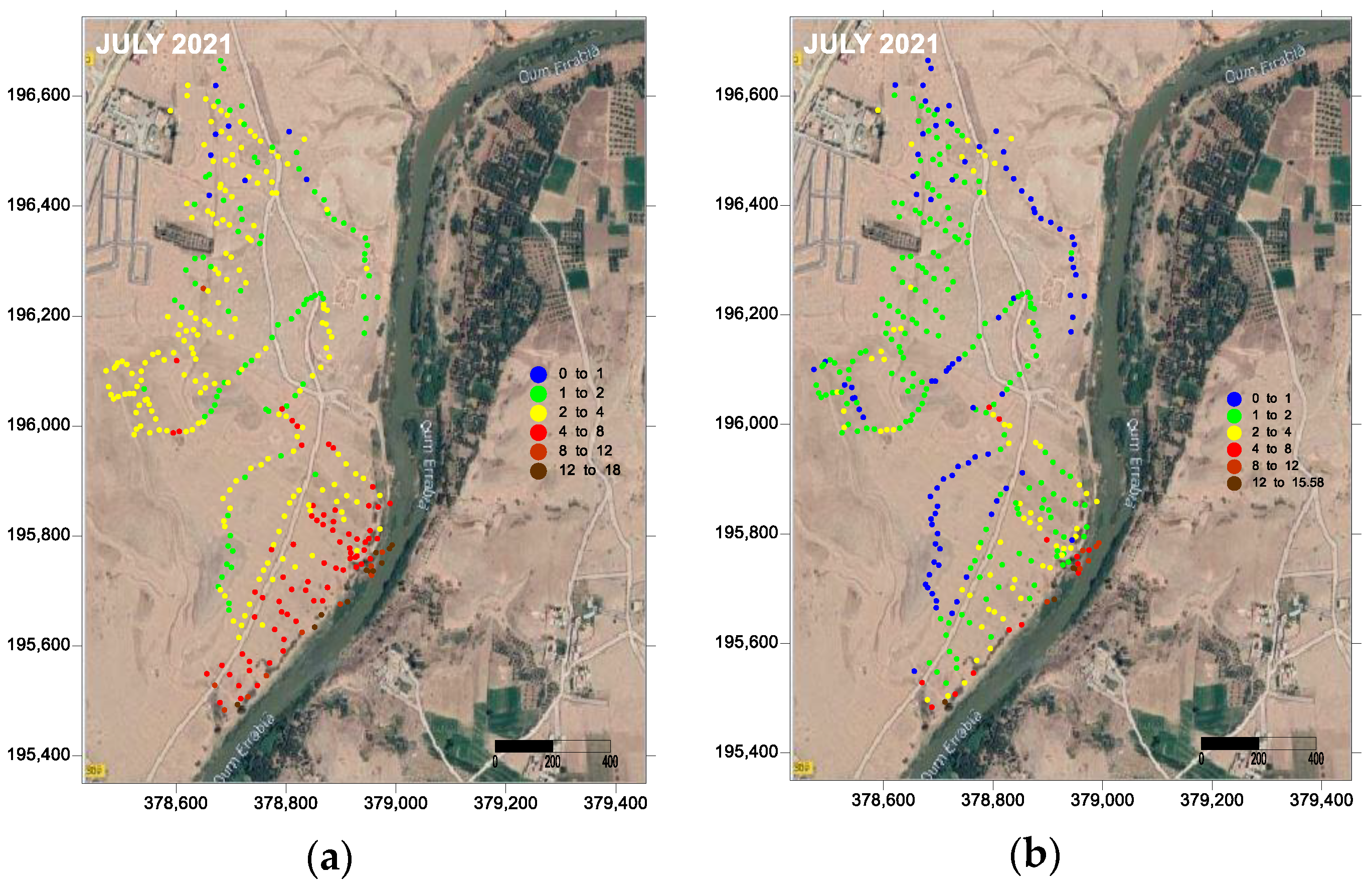
The Geonic EM-38RT Instrument was used to map and diagnose highly conductive soil such as salt soils [7]. Its easy and fast implementation allows for the collection of a large amount of data. The field measurement was carried out over two periods. In the first measurement period of July 2019, a total of 320 measurements of electromagnetic conductivity were carried out in half a day and detected by the GPS survey. The second measurement period was in the month of July 2021; during this period, a total of 365 measurements of electromagnetic conductivity were detected by the GPS survey. For both campaigns, a calibration data set corresponded to five measurement points selected from the measurement points mentioned above so as to spatially represent the entire study area. For each point, the GPS position, the deep conductivity VD (0–0.80 m), and surface conductivity HD (0–0.40 m) were measured. Upstream, the measurements were carried out along paths that intersect the valleys with a distance of about 7 m between the measurements, intensifying the measurements closer to the downstream.

3. Results and Discussion

3.1. Calibration of Electromagnetic Response

In order to be able to express the electromagnetic measurements (ECa) in terms of the soil salinity of the root zone, sampling was carried out for calibration of the electromagnetic conductivity measurements using data from five points scanning the entire range of salinity.
A linear relation was established between ECaH obtained in the field and ECe measured on the saturated extracts, with a correlation coefficient (r2) of 0.94.

3.2. Apparent Electromagnetic Conductivity

The ECaV and ECaH salinity maps of the two components (Figure 2 and Figure 3) show a certain salinity gradient oriented from north-west to south-east where (1) non-saline soils (less than mS/m) occupy most of the Talweg head area (northwest part); (2) the slightly saline soils (between 2 mS/m and 4 mS/m) occupy a large part mainly in cultivated plots (between the Talweg head and Oued Oum Er Rbia = terrace); (3) saline soils (above 4 mS/m) occupy a large part along the Oued Oum Er Rbia. The distribution of salinity is a function of the distance from the drains, suggesting the existence of movement of salts from upstream to downstream.
Salt distribution showed a systematic increase in ECa from the watershed to the valley, with salinity increasing downstream of geological structures. Salt distribution has been controlled by the geomorphologic properties of the basin, which control hydrological and hydrogeological processes, and by the recharge discharge mechanisms that influence salt mobilization and accumulation.

3.3. A Negative Hydrogeological Balance and Increasing Groundwater Salinity

In our study area, the depth of the water table has been increasing over the last 24 years. This trend is in agreement with the observations of farmers who mention episodes wells drying up in recent years. This result highlights the effect of water withdrawal from wells on the local hydrogeological balance as observed in many irrigated plains in arid regions [2,3,4,5,6,7,8].

4. Conclusions

Groundwater dynamics and management are essential determinants of salinity. In the absence of a functional drainage system or in the case of excessive irrigation using poor-quality water, the downstream areas are subjected to congestion and the process of salt concentration, which is enhanced due to evaporation. Conversely, when drainage is efficient, large quantities of salts can then be exported.

Author Contributions

Project administration: A.E.H.; conceptualization, formal analysis, funding acquisition, and resources: A.E.H., Y.E.M., V.V. and M.M.; methodology: V.V.; software: A.E.H., Y.E.M. and H.D.; investigation: M.M.; data curation: A.E.H., Y.E.M. and M.M.; writing—original draft preparation and editing review: A.E.H., Y.E.M., M.M., V.V., H.Y. and H.D.; visualization and validation: V.V. and M.M.; supervision: V.V., M.M., H.D. and H.Y. All authors have read and agreed to the published version of the manuscript.

Funding

This research received no external funding.

Institutional Review Board Statement

Not applicable.

Informed Consent Statement

Not applicable.

Data Availability Statement

The data presented in this study are available on request from the corresponding author.

Acknowledgments

The authors wish to thank Avignon and Abdelmalek Essaadi Universites, and the Dean of the National Institute of Agricultural Research. The authors are also grateful to the staff of the Hydrogeology Laboratory of Avignon for their help and support. Critical and constructive reviews of the manuscript by the reviewers were greatly treasured.

Conflicts of Interest

The authors declare no conflict of interest.

References

  1. Jebbour, S. Combined Use of Surface Water and Groundwater in the Perimeter of the Tadla: Quantitative and Qualitative Aspect. Third Cycle Dissertation in Rural Engineering, Agronomic and Veterinary Institute Hassan II, Rabat, Morocco, 1995; p. 177. [Google Scholar]
  2. Bouchaou, L.; Choukr-Allah, R.; Hirich, A.; Ennasr, M.S.; Malki, M.; Abahous, H.; Bouaakaz, B.; Nghira, A. Climate Change and Water Valuation in Souss-Massa Region: Management and Adaptive Measures. Eur. Water 2017, 60, 203–209. [Google Scholar]
  3. El Hamdi, A.; El Mouine, Y. Sources of spatial variability of soil salinity: The case of Beni Amir irrigated command areas in the Tadla Plain, Morocco. Arid. Land Res. Manag. 2022, 6, 140–147. [Google Scholar] [CrossRef]
  4. Devkota, K.P.; Devkota, M.; Rezaei, M.; Oosterbaan, R. Managing salinity for sustainable agricultural production in salt-affected soils of irrigated drylands. Agric. Syst. 2022, 198, 103390. [Google Scholar] [CrossRef]
  5. Dakak, H.; Huang, J.; Zouahri, A.; Douaik, A.; Triantafilis, J. Mapping Soil Salinity in 3-Dimensions Using an EM38 and EM4Soil Inversion Modelling at the Reconnaissance Scale in Central Morocco. Soil Use Manag. 2017, 33, 553–567. [Google Scholar] [CrossRef]
  6. Amezketa, E. Soil salinity assessment using directed soil sampling from a geophysical survey with electromagnetic technology: A case study. Span. J. Agric. Res. 2007, 5, 91–101. [Google Scholar] [CrossRef]
  7. Soudi, B.; Badraoui, M. The Storage of Organic Carbon in Dryland Soils of Africa Constraints and Opportunities. In Soil and Fertilizers Managing the Environmental Footprint; Lal, R., Ed.; CRC Press: Boca Raton, FL, USA, 2020; p. 372. [Google Scholar]
  8. Qadir, M.; Sharma, B.R.; Bruggeman, A.; Choukr-Allah, R.; Karajeh, F. Non-Conventional Water Resources and Opportunities for Water Augmentation to Achieve Food Security in Water Scarce Countries. Agric. Water Manag. 2007, 87, 2–22. [Google Scholar] [CrossRef]
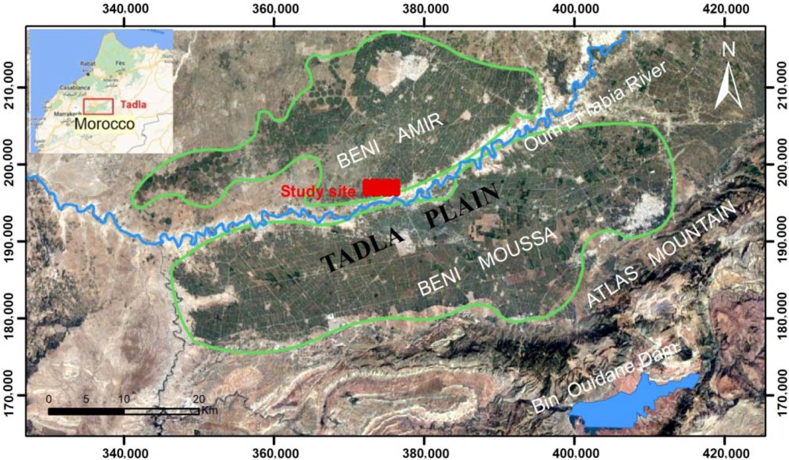
Figure 1. Study area under the irrigated perimeter of Tadla, Morocco.
Environsciproc 16 00009 g001
Figure 2. Distribution of ECaV (a) and ECaH (b) in July 2019.
Environsciproc 16 00009 g002
Figure 3. Distribution of ECaV (a) and ECaH (b) in July 2021.
Environsciproc 16 00009 g003
Publisher’s Note: MDPI stays neutral with regard to jurisdictional claims in published maps and institutional affiliations.