Proceeding Paper

Mapping and Analysis of Irrigation Water Quality in the Coastal Region of Skhirat, Morocco †

1
Department of Chemistry, Faculty of Sciences, Mohammed V University, P.O. Box 1014, Rabat 10100, Morocco
2
Research Unit on Environment and Conservation of Natural Resources, Regional Center of Rabat, National Institute of Agricultural Research (INRA), P.O. Box 6356, Instituts, Rabat 10101, Morocco
3
Laboratory of Research and Development in Engineering Sciences, Faculty of Sciences and Techniques, Abdelmalek Essaadi University, P.O. Box 34, Ajdir, Al Hoceima 32003, Morocco
*
Author to whom correspondence should be addressed.
Presented at the 1st International Online Conference on Infrastructures, 7–9 June 2022; Available online: https://ioci2022.sciforum.net/.
Environ. Sci. Proc. 2022, 16(1), 20; https://doi.org/10.3390/environsciproc2022016020
Published: 16 June 2022
(This article belongs to the Proceedings of The 2nd International Laayoune Forum on Biosaline Agriculture)

Abstract

:
This study analyzes map irrigation water quality in the region of Skhirat, Morocco. This study involves the evaluation of the physico-chemical quality of the irrigation water using Piper and ULSS diagrams and spatial mapping using GIS. The results showed significant salinization power, and demonstrated that the salinity and alkalinity classes of irrigation water dominating in the region are C3-S1 (i.e., average to poor quality; ‘use with caution’), C4-S1 (i.e., poor quality; ‘exclude sensitive plants and heavy soils’), and C4-S2 (i.e., poor quality; ‘to be used with great care, only in light soils’). The evaluation of the Piper diagram determines two hydrochemical facies. The bathymetric map indicates a shallow level downstream and South-West. The salinity map shows high salinity downstream and upstream. In conclusion, a very alarming degradation of water in terms of salinity is noted in the region.

1. Introduction

Morocco is essentially a semi-arid country with limited rainfall (rainfed system), which reduces opportunities for agriculture. To feed the ever-growing population, irrigation is necessary. Groundwater is the major source of irrigation. However, the long-term use of groundwater would have negative impacts on soil quality and the sustainability of agricultural production [1].
Groundwater is the main source of drinking, agricultural, and industrial water. The increase in the exploitation of groundwater and increasingly unfavorable climatic conditions (especially the rainfall variability) have led to the reduction of the aquifer reserves and deteriorate groundwater quality [2]. These pose a danger to the sustainability of the land-use system. The most notable degradation process is the salinization of groundwater [3]. Therefore, the aim of this study was to identify the problem of water salinity, identify areas at risk, and find solutions for the management of these resources. This study consists of mapping and analyzing the quality of groundwater used for irrigation in the coastal region of Skhirat, Morocco, which is one of the most important market gardening areas in the Rabat-Salé region. This study assesses the degree of degradation and provides support for developing decision-making tools.

2. Material and Methods

2.1. Study Area

This study was carried out in the perimeter of Skhirat (270 km2), located in the Rabat-Salé-Kenitra region. The study region lies between Wadi Ykem and Wadi Cherrat rivers and is part of the coastal Meseta. It is one of the agricultural regions with strong market gardening activities and farming based on irrigation water using groundwater. The climate of the region is dry in summer and semi-humid in winter. In the region, the average annual rainfall is 580 mm and averaged temperature around 17.5 °C. The geology of the region shows impermeable to slightly permeable primary formations of the schistose, sandstone, quartzitic, and limestone and permeable Mio-Plio-Quaternary formations. The Miocene presented by marls and limestones and the Plio-Quaternary consists of sands, gravel, and marine detrital limestone.

2.2. Water Sampling and Laboratory Analysis

In order to assess the state of the hydrochemical quality of irrigation water, a water monitoring campaign was carried out in the area. Water samples were collected from a network of 77 water points in hermetically sealed plastic bottles bearing the site code (Px), with P referring to the well and x the site number, and Lambert coordinates (X, Y) were taken using a GPS (Figure 1). The groundwater level is measured in situ using a piezometric probe. The water samples were then taken to the water analysis laboratory of the Research Unit on the Environment and the Conservation of Natural Resources—INRA-Rabat. Various physicochemical analyzes of the water (electrical conductivity, pH, and ion balance) were carried out.

2.3. Mapping

The thematic maps were elaborated using spatial interpolation within Geographic Information System (GIS). We used the Geostatistical Analysis extension of the ArcGis 10 © software. The interpolation algorithm was the Inverse Distance Weighting (IDW).

3. Results and Discussion

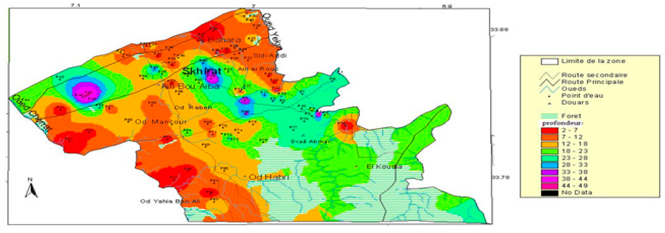
3.1. Groundwater Depth

The bathymetric map shows that the depth of the water table oscillates between 2 and 45 m with an average of 16.5 m. The aquifer is closer to the surface in the downstream areas of the region, and to the South-West; this is due to the infiltration of water from the rivers and the sea. At the central and South-East parts, the aquifer is deeper, reaching 45 m (Figure 2).

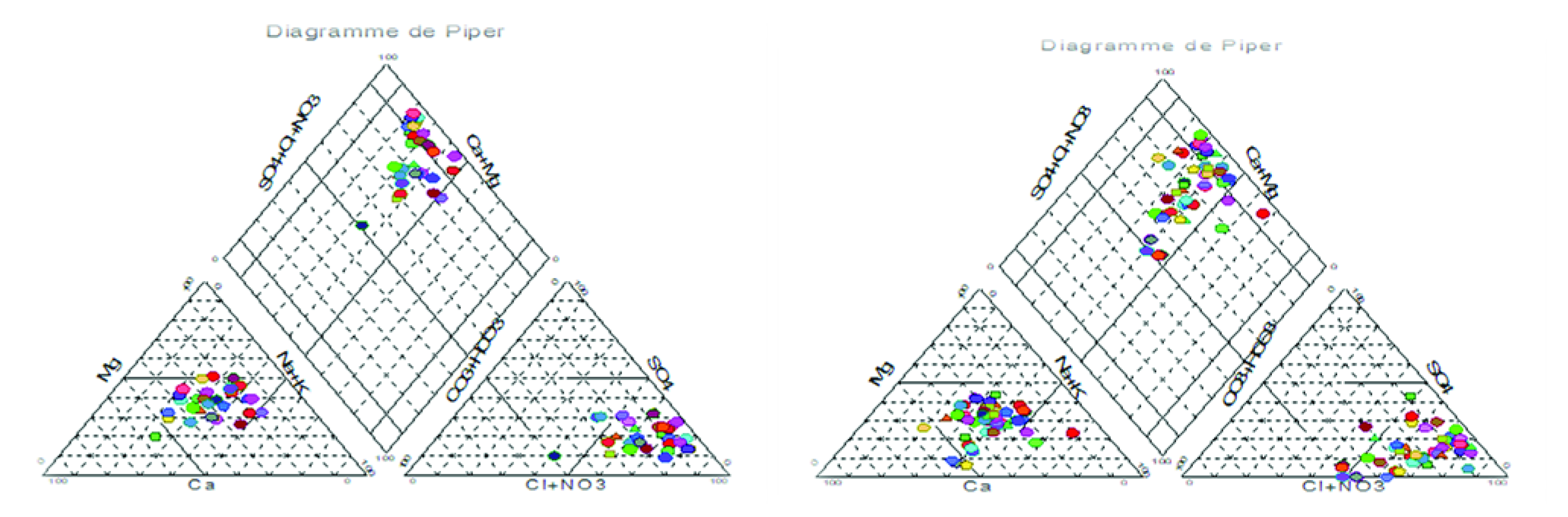
3.2. Chemical Facies of Waters

The representation of the chemical results of the waters on the Piper diagram (Figure 3) made it possible to distinguish two types of facies that characterize the waters of Skhirat (sodium chloride facies in particular in the downstream and central zones and calcium chloride facies in the upstream zone).

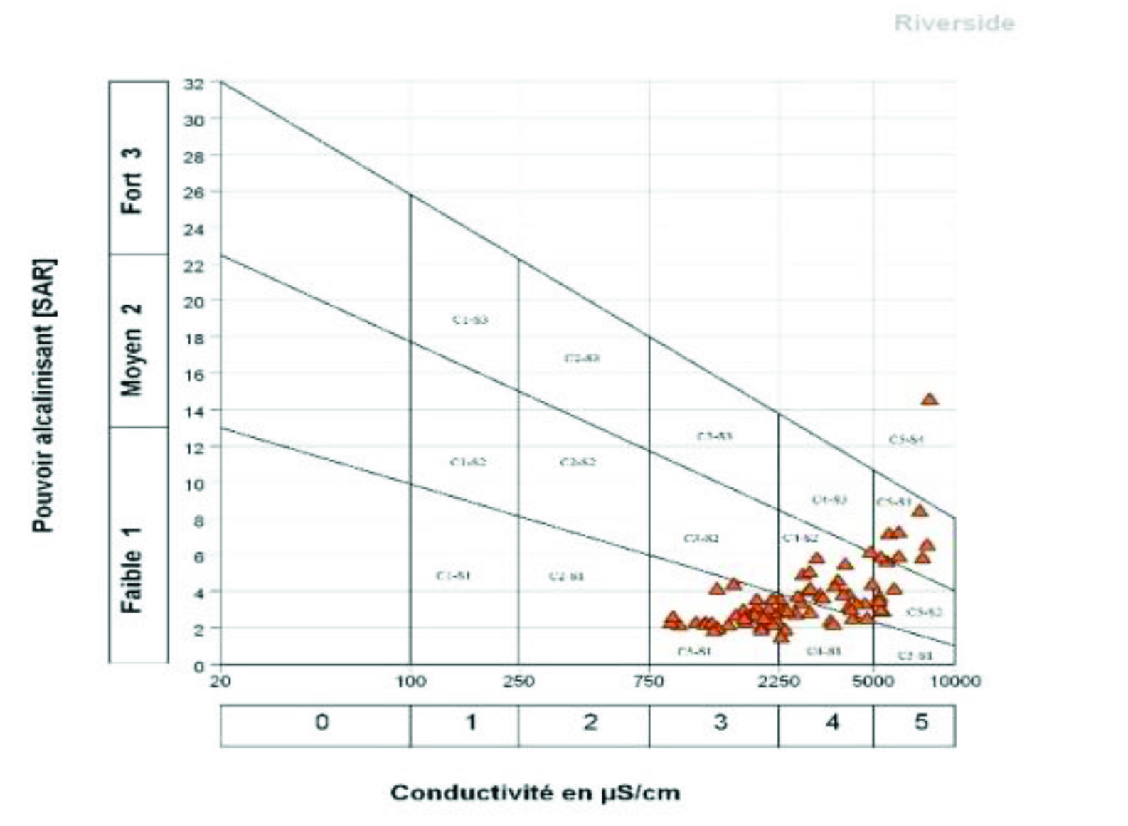
3.3. Water Salinity and Alkalinity

The classification of waters, according to the American classification diagram proposed by USSL Riverside (Richards, 1954) (Figure 4), shows that the dominant classes are C3-S1 and C4-S2 (Table 1). These waters are very strongly to extremely saline and therefore have a very strong salinizing power on the soil (which can cause a reduction in the yields of sensitive crops). A total of 80% of the irrigation waters have a SAR of less than 8, and therefore these waters present a relatively low risk of alkalinization.

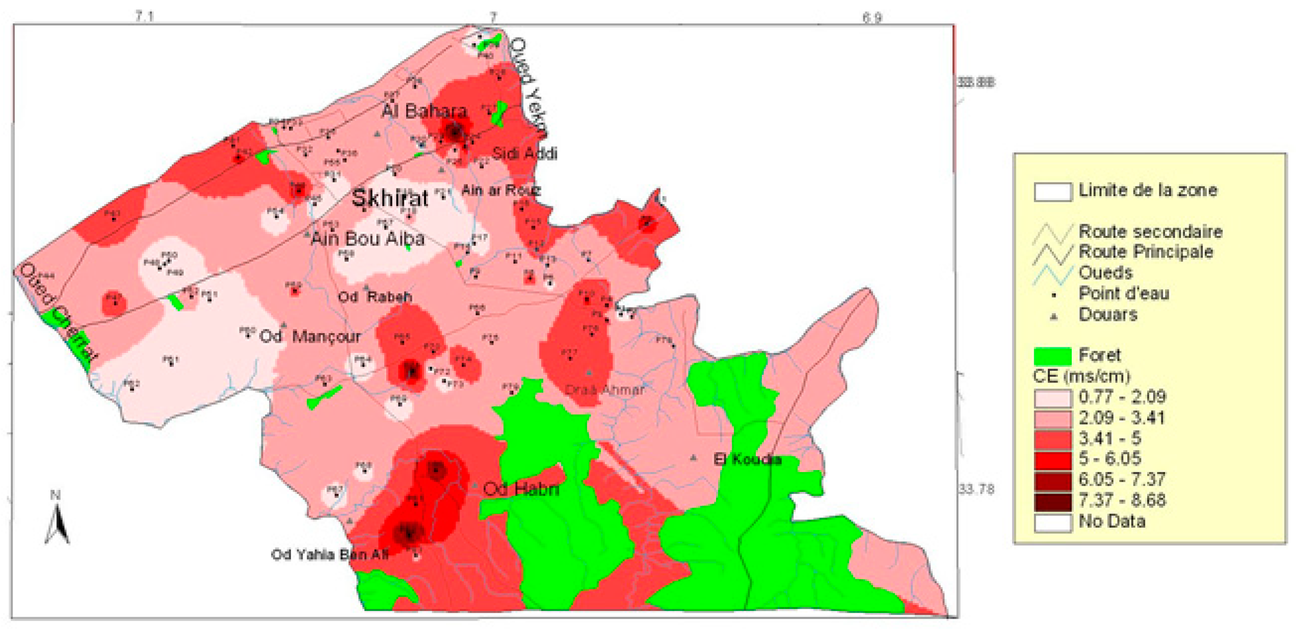
3.4. Water Salinity Mapping

The results found that the water salinity varies in a wide range from 0.9 to 8.1 dS/m with an average of 3.2 dS/m (Table 2). The map of the spatial distribution of water salinity shows that the majority of wells located in the downstream (coastal) and upstream parts of the region have high salinity. Those belonging to the middle part are relatively less saline. This can be explained by the effect of marine intrusion and the low-level depth of the water table in the littoral zone. In the upstream zone, water salinity may be due to the interaction of water with the geological formation of the shale aquifer, characterized by poor quality water. As for the middle part, the waters have a low salinity which can be attributed to the high permeability of the limestone formations of the aquifer (Figure 5).

4. Conclusions

The study analyzed and mapped the irrigation water quality (and in particular the salinity) in the Skhirat area of Morocco to assess its potential for degradation. This study showed a significant salinization power of these waters, especially in the upstream and downstream parts of the region, with relatively low risk of alkalinization. The salinity and alkalinity classes of irrigation water dominant in the region are C3-S1, C4-S2, and C4-S1. The dominant chemical facies are chloruro-sodium type in the downstream and central zones and chloruro-calcic in the upstream zone. The spatial mapping of the salinity and the depth of the water table made it possible to locate the sensitive zones of the region. Thus, the coastal and upstream areas of the region may have soil salinity problems in the future due to the high salinity of the waters in these areas.

Author Contributions

Conceptualization, H.D., A.D. and A.G.; Sampling and laboratory analyses, I.M., A.Z. and H.Y.; Software, I.M.; Orignal draft preparation, I.M.; Writing review and editing, H.D., A.D., H.I., H.C.D. and A.G. All authors have read and agreed to the published version of the manuscript.

Funding

This research was funded by INRA in the frame of Agroecology mega-project. subsidized by the general budget of INRA. The APC was funded by the LAFOBA2 organizers. Subsidized by INRA′s general budget.

Institutional Review Board Statement

Not applicable.

Informed Consent Statement

This study did not include humans.

Data Availability Statement

Data can be supplied if required.

Conflicts of Interest

The authors declare no conflict of interest.

References

  1. Devkota, K.P.; Devkota, M.; Rezaei, M.; Oosterbaan, R. Managing salinity for sustainable agricultural production in salt-affected soils of irrigated drylands. Agric. Syst. 2022, 198, 103390. [Google Scholar] [CrossRef]
  2. Dakak, H.; Huang, J.; Zouahri, A.; Douaik, A.; Triantafilis, J. Mapping soil salinity in 3-dimensions using an EM38 and EM4 Soil inversion modelling at the reconnaissance scale in central Morocco. Soil Use Manag. 2017, 33, 553–567. [Google Scholar] [CrossRef]
  3. Sehlaoui, H.; Hassikou, R.; Dakak, H.; Zouahri, A.; El Hasini, S.; Iaaich, H.; Ghanimi, A.; Douaik, A. Nitrate contamination and associated health risks of the Benslimane groundwater, Morocco. Environ. Geochem. Health 2022, 1–16. [Google Scholar] [CrossRef] [PubMed]
Figure 1. Location of water samples.
Environsciproc 16 00020 g001
Figure 2. Spatial distribution of the water table depth.
Environsciproc 16 00020 g002
Figure 3. Piper diagram for waters downstream (left) and upstream (right).
Environsciproc 16 00020 g003
Figure 4. Classification of irrigation water (Richards, 1954).
Environsciproc 16 00020 g004
Figure 5. Groundwater salinity map from the Skhirat region.
Environsciproc 16 00020 g005
Table 1. Classification of irrigation water according to salinity (Richards, 1954).
Salinity and Alkalinity ClassInterpretation% of Wells
C3-S1Average to poor quality. Use with caution.39
C4-S1Poor quality. Exclude sensitive plants and heavy soils.16
C4-S2Poor quality. To be used, with great care, only in light soils.29
C5-S2Very poor quality. To be used only in exceptional circumstances.1.5
C5-S3Very poor quality. To be used only in exceptional circumstances.13
C5-S4Very poor quality. To be used only in exceptional circumstances.1.5
Table 2. Classification of irrigation water based on electrical conductivity.
Salinity ClassSymbolEC (dS/m)Number of Wells% of Wells
No salineC1<0.2500
Moderately salineC20.25–0.7500
Strongly salineC30.75–2.253140
Very strongly salineC42.25–53242
Extremely salineC5>51418
Publisher’s Note: MDPI stays neutral with regard to jurisdictional claims in published maps and institutional affiliations.

