Article

The Impact of Land Cover on Nest Occupancy of the White Stork (Ciconia ciconia (L.)): A Case Study of Kampinos Forest, 2006–2018

by
Joanna Bihałowicz
1,2,*,
Axel Schwerk
1,
Izabela Dymitryszyn
1,
Adam Olszewski
3 and
Jan Stefan Bihałowicz
4
1
Institute of Environmental Engineering, Warsaw University of Life Sciences SGGW, ul. Nowoursynowska 166, 02-787 Warszawa, Poland
2
Faculty of Civil Protection and Security Engineering, Fire University (former The Main School of Fire Service), ul. Juliusza Słowackiego 52/54, 01-629 Warszawa, Poland
3
Kampinos National Park, ul. Tetmajera 38, 05-080 Izabelin, Poland
4
Institute of Safety Engineering, Fire University (former The Main School of Fire Service), ul. Juliusza Słowackiego 52/54, 01-629 Warszawa, Poland
*
Author to whom correspondence should be addressed.
Earth 2024, 5(3), 336-353; https://doi.org/10.3390/earth5030019
Submission received: 30 May 2024 / Revised: 27 July 2024 / Accepted: 30 July 2024 / Published: 1 August 2024

Abstract

:
Land cover is one of the spatial factors influencing the ecological niche of animal populations. Some types of land cover predetermine a particular site as a habitat for certain species. One of the flagship species of agrocenosis is the white stork (Ciconia ciconia (L.)). This study focuses on the occupancy of 122 nests in the vicinity of Kampinos National Park in Poland. This area is a mixture of traditional agricultural settlements, forests, the Vistula valley, and the suburbs of Warsaw, Poland. This mix allows for the identification of land cover disturbances that affect the white stork’s nest occupancy. The current state of development and the efficiency of remote sensing-based land cover databases allows us to easily identify spatial factors affecting nest occupancy and to analyse them in a longer timeframe. The study analyses land cover in buffers of 1 to 5 km around white stork nests based on CORINE Land Cover (CLC) for the years 2006, 2012, and 2018. Although the white stork’s habitat is well studied, the CLC-based results provide significant new insights. The results show that nest occupancy increases with an increasing proportion of agricultural land, especially with significant natural vegetation, while the proportion of wetlands and water is not significant. This work provides a description of the ideal habitat for the white stork in terms of nest occupancy.

1. Introduction

It is well documented that birds are highly sensitive to alterations in ecosystem conditions, particularly in the case of indicator species [1]. This phenomenon can be attributed to a number of factors. For example, evidence suggests that metal pollution may result in observable alterations in plumage colouration and a reduction in reproductive success in the tree swallow (Tachycineta bicolor (Vieillot)) [2]. Similarly, a reduction in the number of breeding sites has been identified as a significant stress factor for the purple martin (Progne subis arboricola (L.)) [3]. Furthermore, land cover change has been identified as a potential factor affecting birds of prey, particularly in relation to the territory occupation of the barred owl (Glaucidium brasilianum) population [4]. Other studies utilising the CORINE Land Cover (CLC) satellite database have demonstrated that certain avian species exhibit a greater prevalence on extensively managed agricultural land. For example, the presence of semi-natural habitats has been demonstrated to increase the likelihood of grey shrike (Lanius excubitor) or red-backed shrike (Lanius collurio (L.)) breeding and to positively affect their breeding success [5,6]. Other examples include the American white ibis (Eudocimus albus (L.)) and the wood stork (Mycteria americana (L.)). These birds are strongly associated with hydrological conditions and are considered to be reliable indicators of ecosystem quality [7]. One of the most widely discussed aspects of land use change that affects populations of organisms is deforestation. The decline in the population of forest-specialised bird and mammal species is a consequence of deforestation, while the increase in multi-habitat species leads to the cessation of the ecosystem in question [8].
One avian species employed to gauge the prevalence of common birds in agricultural landscapes in Poland is the white stork (Ciconia ciconia (L.)). The white stork occupies a unique position in Polish folklore, tradition, culture, and literature, serving as an informal symbol of the Polish countryside [9].
The white stork (Figure 1) is a large wading bird belonging to the stork family, Ciconiidae. The species reaches a height of approximately 100–125 cm and has a wingspan of up to 2 m. The weight of an adult is up to 4.5 kg. Mature individuals exhibit red colouration of the beak and legs. The head, thorax, and tail are covered with white feathers, while the white wings are also covered with black ailerons [10]. The species breeds in Poland. The birds arrive from their wintering grounds in March and depart for eastern and southern Africa in August [11,12]. The white stork’s natural habitats include agricultural areas, rural areas, wetlands and floodplains as secondary habitats, and steppes with scattered woodland [13]. The foraging grounds of these storks are located in permanent grasslands, including meadows, pastures, legume crops, field baulks, and shallow bodies of water. However, they are less frequently observed in cultivated fields. The number of breeding pairs is, in turn, related to the percentage of grassland in the surrounding habitat, as demonstrated by a study conducted in Brandenburg [14]. In contrast, Swedish researchers have observed that the reduction in wetlands and semi-natural grasslands across much of Europe has resulted in a notable decline in the population of this species [15]. In Poland, the white stork avoids dense forest complexes and intensively urbanised areas [16]. The species originally constructed nests in aged trees; however, as human civilisation and anthropogenic pressure increased, it began to nest in human settlements. It has recently been observed that the white stork has begun to select technical infrastructure, including high-voltage poles, chimneys, and streetlights, as its preferred nesting site [17,18,19].
The first nationwide census of the white stork’s population was conducted as early as 1958 [20]. The white stork’s long-term presence in tradition and culture has resulted in a substantial body of data on its population, accumulated over many years of observation [14,21]. The white stork is described as a flagship species, an umbrella species, an indicator species, and as being relatively easy to identify and study. It is a useful species for biodiversity studies, occupying territories with a larger food base, which also have a larger number of bird species [22]. It is also useful for monitoring landscape quality and change; as a landscape species, it requires connected ecosystems at different stages of succession to occur. This provides a rationale for the proposition that it can indicate a specific compositional configuration of the landscape [23]. The quality of the environment can be evaluated by examining the degree of heavy metal contamination, which can be determined by analysing the blood and feathers of these birds [24].
The objective of the present study was to ascertain the impact of land cover and the associated landscape composition on the nesting behaviour of the white stork (Ciconia ciconia (L.)). In light of the characteristics of habitat needs that have arisen in the white stork, largely due to the nature of anthropogenic land use and indirectly from land cover and the associated characteristic landscape layout, we hypothesised that an increase in the number of meadows, pastures, and extensive arable land areas and a decrease in the number of forests and anthropogenic areas would positively influence nest occupancy. Furthermore, it was hypothesised that the correlations between land cover and nest occupancy would decrease with increasing distance between the area of analysis and white stork nests.

2. Materials and Methods

2.1. Research Area

The selected study region encompasses Kampinos National Park, Poland, and its surrounding buffer zone (Figure 2). The boundaries of the study area were delineated based on the location of 122 white stork nests, as documented by Dr A. Olszewski between 2006 and 2018 (unpublished). These data were used to establish buffers of up to 5 km from the nest. This is the distance at which the white stork feeds most often, as reported by Romero Lopez [25] and Zurell et al. [26]. This distance varies depending on the growth of the young and their need for food, as observed by Dziewiaty and Schulz [27] and Podlaszczuk et al. [28]. The total area of the study area was 1188 km² (without double-counting overlapping areas). The study area was divided into individual study plots, which were delineated by circles with radii of 5, 4, 3, 2, and 1 km from the locations of the white stork nests included in this study. This study analysed 122 nests, focusing on the proportion of specific land cover according to the CLC in five circular buffers with radii ranging from 1 to 5 km. For each nest, the results of zonal histogram GIS analyses were correlated with nest occupancy in order to determine which parameters of the neighbourhood land cover predetermine the nest to be occupied and which do not.

2.2. Data on the White Stork

Data on the white stork in Kampinos National Park, including the buffer zone used in this study, were derived from long-term observations conducted on a full scale since 2004 by Dr. A. Olszewski. The information identified in them is consistent with the methodology developed over many years of research on this species [16]. In the study area, the population of the white stork from 2006 to 2018 can be described as stable in terms of abundance and prevalence rates, similar to the fluctuations found in the national population, which has been studied since 2001 as part of Flagship Bird Species Monitoring [29]. Further analysis employed the parameter “nest occupancy,” created on the basis of ornithological data, to describe the white stork population. The variable is described in Table 1. It can have two values (it is a binary variable): 0 means the nest is unoccupied and 1 means that the nest is occupied. A value of 1 was assigned to the nest if the HP category was assigned to the nest, i.e., when a pair of birds was present for more than a month. The remaining categories of bird inventory, HO (unoccupied), HB1 (visited by single stork), HB2 (visited by pair), or HBx (visited by pair or single stork), were assigned a value of 0. Detailed conditions and explanations are provided in Table 1.
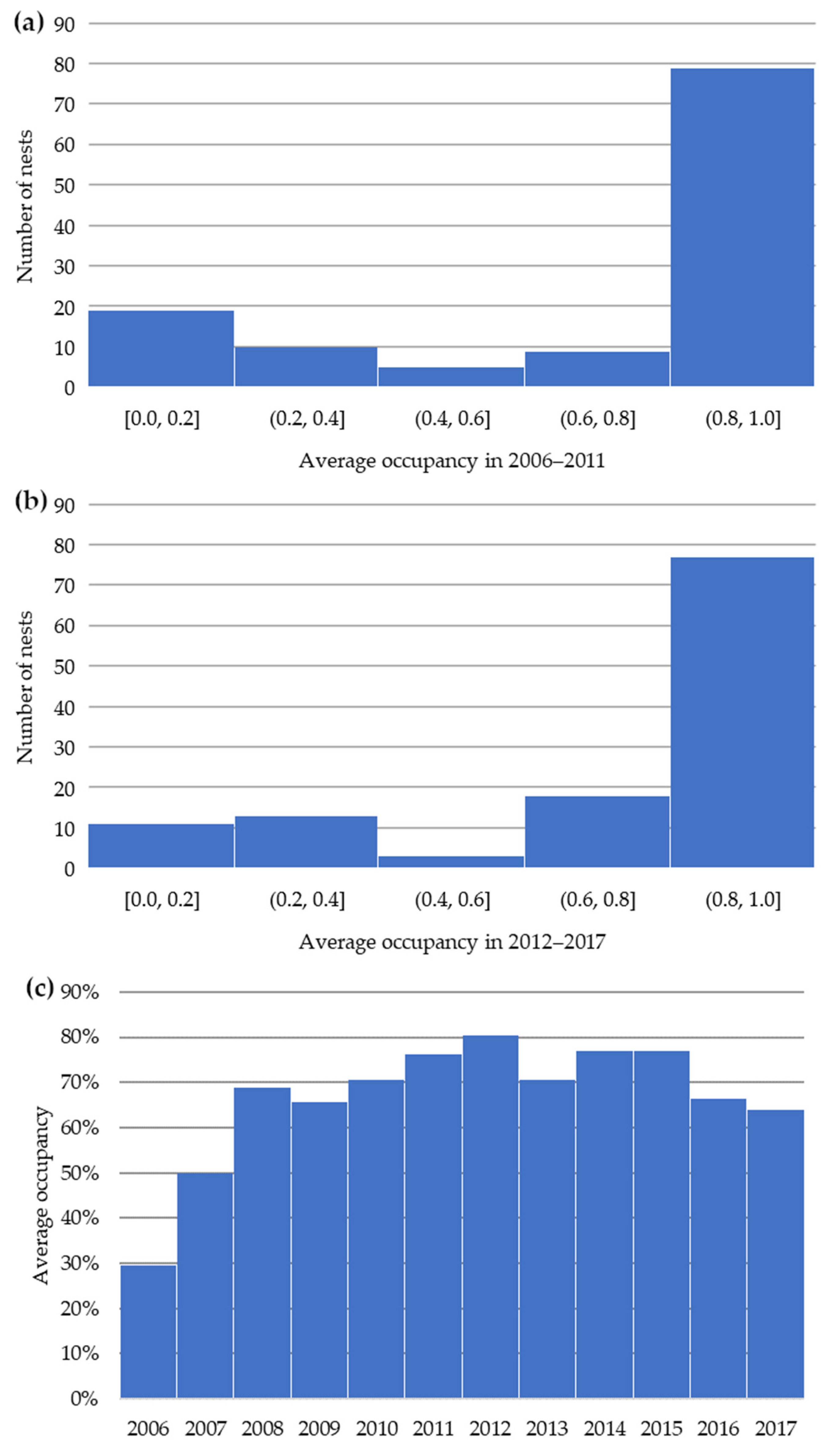
The data about the population of the white stork in Kampinos are summarised in Figure 3. The average nest occupancy during the 12-year period, based on data on 122 investigated nests, was 80.1%. Using this value, we performed Student’s t-test with the null hypothesis H 0 ( μ = 0.801 ) versus alternative hypothesis H 1 ( μ 0.801 ) . We found that there were no reasons to reject the null hypothesis at α = 0.001 , and only for the years 2012 and 2017 can H 0 be rejected at α = 0.01 . This gives additional evidence for the stork population’s stability.

2.3. CORINE Land Cover

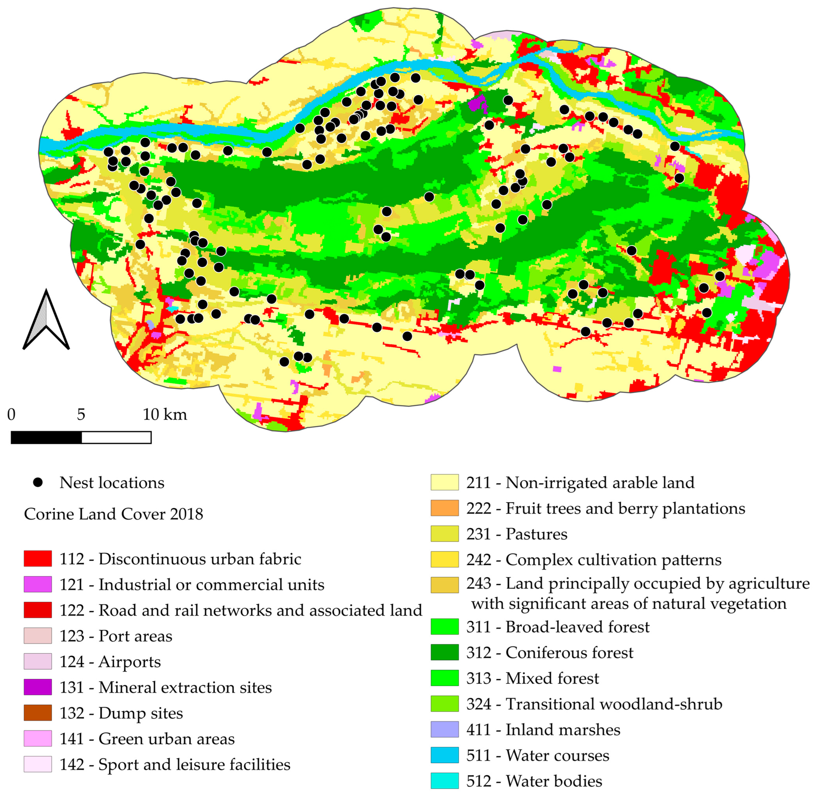
The research described in this paper utilised land cover maps created by the CORINE Land Cover (CLC) project (Figure 4). These maps were created using a 100 × 100 m grid and presented as a cartographic product at a scale of 1:100,000. The thematic accuracy of the land cover inventory is more than 85% [30]. Land cover was mapped at a three-degree accuracy level, allowing for the classification of the entire territory covered by the programme and the unambiguous definition of the terminology used in the headings. The first degree of accuracy is divided into five main categories of land cover, which are found throughout the globe: artificial surfaces (1), agricultural areas (2), forest and semi-natural areas (3), wetlands (4) and reservoirs (5). The second level comprises 15 coverage classes, which are intended for use at scales of 1:500,000 and 1:1,000,000. The third level, the most accurate, comprises 44 coverage classes, which are used to create maps at a scale of 1:100,000 and in CORINE. Of these, only some are located in the study area as shown in Table 2.
This study employed the CORINE Land Cover (CLC) land cover database to determine land cover and its changes. This entailed analysing the proportion of each land cover category for the entire study area, with total study plots determined by circles with successive radii from 1 to 5 km from the white stork nests. The same approach was applied to individual study plots at each nest. Analyses were conducted for all three levels of accuracy of the CLC database for the years 2006, 2012, and 2018.
Changes in land cover in the study area, at all three levels of CORINE Land Cover (CLC) accuracy, were correlated with white stork nest occupancy in yearly data from 2006 to 2018. Since the CLC was released in 2006, 2012, and 2018, we determined that CLC 2012 can be related to data on the white stork population in the years 2006–2011 and, accordingly, CLC 2018 is related to data for the period 2012–2017. For both periods, we averaged nest occupancy. This separate analysis allowed us to catch the changes in both land cover patterns and in nest occupancy.

2.4. Statistical and Spatial Analyses

The statistical analyses provided in this work focused on determining the sign and strength of the correlation between CLC land cover share and nest occupancy. Since CLC is available every six years, we decided to average the nest occupancy over 6-year periods. The average occupancy, separately for each period, was correlated with land use shares in five buffers in order to identify both temporal and spatial effects. As a measure of correlation, Pearson’s linear correlation coefficient, r P , a parametric coefficient, was employed in the correlation analysis [31]. The statistical significance of the linear correlation coefficient was determined using Fisher’s transformation [32]. The sample size for each correlation was 122 pairs. The correlated values of land cover shares were based on the zonal histograms of the CORINE Land Cover raster for 2006, 2012, and 2018. The zones were defined as circular buffers of the study area, as described in Section 2.1. Spatial analyses were carried out using QGIS 3.22 Białowieża [33], while correlation parameters and associated analyses were performed using the SciPy 1.7.3 [34], Pandas 1.4.3 [35], and NumPy 1.21.5 [36] Python 3.9.7 [37] packages and functions available in the R language 3.6.1 [38].

3. Results

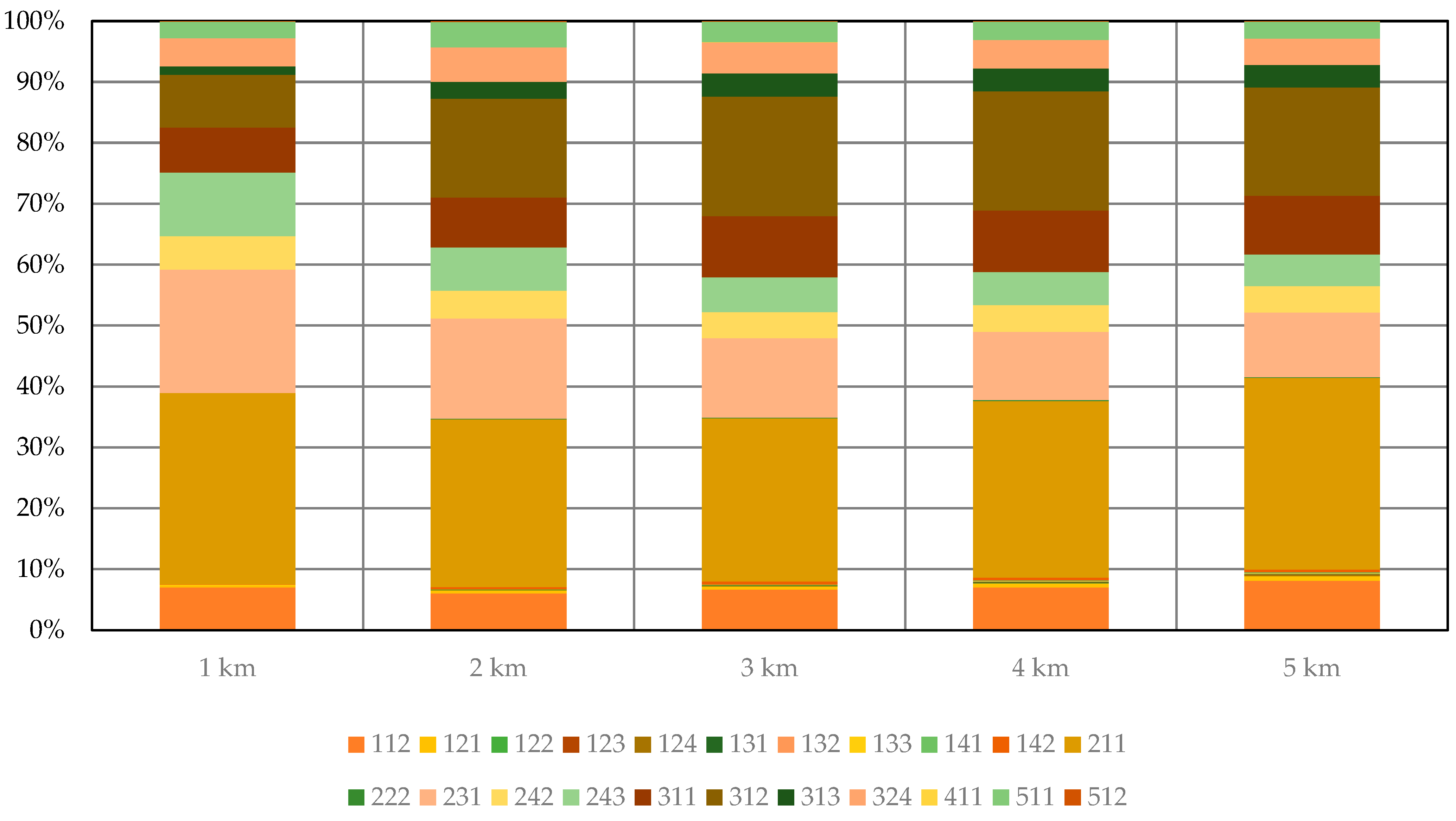
The proportion of each land cover category showed clear changes with increasing distance from white stork nests (Figure 5). In 2006, the land cover with the highest share was non-irrigated arable land (code 211 according to the designations in the CLC), covering a percentage of about 30% of the study area, which was not dependent on the distance from the nest. The next significant type of land cover was pastures (231), which increased from 10.5% to almost 20% in the study area. The next significant element within 5 km to 3 km of the nest was coniferous forest (312), which accounted for 19% of the total area. This value decreased to 8.5% at the smallest radius lengths of 2 km and 1 km. A similar pattern was observed for the proportion of broad-leaved forest (311), which decreased from 9.5% to 7%. The presence of discontinuous urban fabric (112) was shown to fluctuate around a rate of 6.5% regardless of distance. Similarly, complex cultivation patterns (242) showed a presence of 4.5%, while transitional woodland/shrub (324) showed a share of 5%. The proportion of land principally occupied by agriculture, with significant areas of natural vegetation (243) increased with decreasing distance from white stork nests, rising from 5% to 11%. The proportion of other types of land cover did not exceed 5%. The occurrence of each type of land cover also varies with distance from white stork nests. Port areas (123) and construction sites (133) were only observed in the largest buffers (5 km) and only for two nests. Airports (124), dump sites (132), and green urban areas (141) were not observed within the plots delineated by 1 and 2 km circles. Similarly, fruit trees and berry plantations (222) do not appear to be the closest land cover types to nests.
In 2012, non-irrigated arable land (211) accounted for the largest share of the study area, at 29% (Figure 6), regardless of the size of the buffer analysed. As in 2006, pastures (231) were an important land cover type. Their percentage increased from 10.5% to 20% as the study area decreased. The proportion of coniferous forests (312) at 5, 4, and 3 km radii from the nests remained at 19%. It then began to decrease with increasing proximity to the nest, reaching 8.5% in the immediate vicinity of the nest. As the study area decreased, the proportion of broad-leaved forests (311) also decreased from 10% to 7.5%. The proportion of discontinuous urban fabric (112) remained constant, at 7%, regardless of distance from the nest. The percentages of complex cultivation patterns (242) and transitional woodland/shrub (324) were 4.5% and 5%, respectively, in 2012, as in 2006. As the study area decreased, the share of land principally occupied by agriculture, with significant areas of natural vegetation increased from 5 to 10.5% (243). The remaining land use categories had a small share of less than 5% of the survey area. The occurrence of each type of land use in 2012 varies according to the distance from white stork nests. Traffic areas and areas associated with road and rail networks and associated land (122), which were previously absent, and port areas (123) were only observed at a 5 and 4 km radii. In the two smallest study areas, airports (124), dump sites (132), and urban green areas (141) are absent. It can be observed that fruit trees and berry plantations (222) and inland marshes (411) are not present near nests, i.e., within a radius of one kilometre.
The proportion of each land cover category in the study area in 2018, as determined by CORINE Land Cover, remained consistent with previous years (Figure 7). The dominant component, accounting for 29% of the total area, was non-irrigated arable land (211). This land cover category was observed to be the most prevalent regardless of distance from white stork nests. In contrast, the proportion of pastures (231) increased from 10.5 to 20% as the study area decreased. The proportion of coniferous forests (312) remained around 19% at a radius of 5 to 3 km but decreased to 8.5% near the nests. Similarly, the proportion of broad-leaved forests (311) decreased from 10 to 7.5%. The proportion of discontinuous urban fabric (112) remained at 7%. The 5% share of transitional woodland/shrub (324) remained unchanged, as did that of complex cultivation patterns (242) (4.5%). Similarly, as in previous study periods, the proportion of land principally occupied by agriculture, with significant areas of natural vegetation (243) increased from 5% to 10.5% as we approached the nest. The other land cover categories had very small proportions, less than 5% over the whole study area. In contrast to previous periods, there were no construction sites (133) in the 2018 study area. Conversely, the two largest study areas contain transport areas and areas related to road and rail networks and associated land (122) and port areas (123). In the study area, at radii of 1 and 2 km from stork nests, airports (124), dump sites (132), and green urban areas (141) do not appear, as in 2006 and 2012. In the smallest study area, at a radius of 1 km from stork nests, fruit trees and berry plantations (222) and inland marshes (411) are again absent.
The correlations between the different categories of use and their influence as a function of distance from the nests examined showed statistically significant correlations between the types and trends of coverage and nest occupancy. It was also shown that the strength of the correlations depended on the distance from the nests, with a general monotonic increase or decrease with distance.

3.1. Results for Level 1 CORINE Land Cover

Correlations between nest occupancy and different land cover types were already observed in the level 1 CORINE Land Cover classification (Table 3). During the initial period of the study, only trends were observed, with positive correlations with agricultural areas (2) and negative correlations with forest and semi-natural areas (3). During the following period, significant correlations were observed with artificial surfaces (1), agricultural areas (2), and forest and semi-natural areas (3). With increasing distance from white stork nests, the statistical significance of the negative effect of artificial surfaces (1) on nest occupancy also increases. In the immediate vicinity of the nests, i.e., within 1 km of the nests, the presence of agricultural areas (2) has the strongest positive effect, which decreases with increasing distance. At radii of 1 and 2 km around the nests, the presence of forest and semi-natural areas (3) has a negative effect on occupancy.

3.2. Results for Level 2 CORINE Land Cover

The second-order accuracy data from the CORINE Land Cover database show that certain land cover categories have more impact on the presence of storks in Kampinos (Table 4). Near the nests, i.e., in the smallest study area, the presence of artificial, non-agricultural vegetated areas (14) has a small negative effect in the first period. In the second observation period, the negative impact of these land cover categories increases with increasing distance from the nests. From 2006 to 2012, nest occupancy is negatively influenced by scrub and/or herbaceous vegetation associations (32). In the immediate vicinity of the nests, i.e., in the study plots delimited by circles with radii of 1 and 2 km, there is a strong negative influence of forests (31). At distances of 2 to 4 km, heterogeneous agricultural areas (24) exert a positive influence. The greater the extent of arable land (21) near nests, the greater the likelihood of occupation. With increasing distance, the negative correlation between nest occupancy and urban fabric (11) increases. Regardless of distance, white stork nest occupancy is negatively influenced by industrial, commercial, and transport units (12).

3.3. Results for Level 3 CORINE Land Cover

The most detailed correlations were shown with land cover in level 3 CORINE Land Cover classification (Table 5). In the initial period, there was a slight negative effect of sport and leisure facilities (142) in the vicinity of nests, defined as within a 1 km radius. A similar pattern emerged for coniferous forests (312). Beyond a radius of one kilometre, transitional woodland/shrub (324) correlated negatively with nest occupancy. In the second phase of the study, it was found that nest occupancy was positively influenced by land principally occupied by agriculture, with significant areas of natural vegetation (243). The proximity of arable land to the nests had a greater effect on nest occupancy than the presence of non-irrigated arable land (211). As the distance from the nests increased, the negative impact of discontinuous urban fabric (112) became more pronounced, with a significant decrease in nest occupancy beyond 2 km. A consistent and pronounced negative effect was observed in the case of industrial or commercial units (121). At distances of more than 4 and 5 km from the nests, respectively, delineated study plots and road and rail networks and associated land (122) also showed negative effects. The same was true for airfields, which had a negative effect at a distance of 3 km or more. Nest occupancy was significantly negatively affected by the presence of landfills and rubbish tips within a radius of up to 5 km. At distances of 4 and 5 km, green urban areas (141) had a negative effect. As the distance from the nests increased, the negative impact of sports and recreational areas on the occupancy of white stork nests also increased (142). The greater the proportion of coniferous forests (312) near nests, as indicated by the study plots delineated by circles with radii of 1 and 2 km, the lower the probability of occupancy. At distances of 2 and 3 km, mixed forests (313) exerted a slight negative influence. The observed inverse relationship between the presence of water bodies (512) and the occupancy of white stork nests was somewhat unexpected.

4. Discussion

The first step in the present study was to analyse the correlation between land cover and distance from white stork nests. This analysis was carried out for two study periods corresponding to the intervals between the CLC databases. These periods were 2006–2012 and 2012–2018. As predicted and previously known for the species [13], the dominant land cover in the study plots was agricultural land (CLC code 2), according to CLC level I, delineated by circles with radii of 1, 2, 3, 4, and 5 km from the nests. For each of the study periods, the study area accounted for more than half of the land area. As expected, the study area was characterised by a significant proportion of forest and semi-natural ecosystems (CLC code 3), accounting for just over a third in each of the study periods. This is due to the location of the study area within Kampinos forest [39,40], which has undergone significant land use changes since the establishment of Kampinos National Park. Indeed, following the establishment of Kampinos National Park, conservation plans were implemented, resulting in the reforestation of former agricultural land and the succession of abandoned agricultural land [41,42,43,44,45].
As the distance from the nests increases, the negative impact of anthropogenic areas (CLC code 1) on the parameters describing the white stork population increases. There were no statistically significant correlations between the proportion of anthropogenic areas in the immediate vicinity, i.e., up to 1 km from the nest, and any of the parameters describing the population of this bird. This may partially confirm the information on the typical foraging area of the stork, which, according to sources, is up to 5 km from the nest, depending on the abundance of the food base [26,46], while nests are built in the vicinity of human settlements, which, as the closest environment, are not suitable for foraging and are not crucial. These observations also seem to be confirmed in the typical landscapes where the white stork is observed. As a bird of agrocenoses, this species is particularly fond of anthropogenic areas as nesting sites. In areas without human settlements, the intensity of poles, which are the most frequently chosen nesting sites [17,18,19], is significantly lower than in rural anthropogenic areas. Given the above, it can be said that the anthropogenic area, i.e., residential buildings, is highly disruptive in the vicinity of white stork nests, while it begins to interfere at greater distances from the nest. At these distances, a strong negative correlation is observed with the presence of discontinuous urban fabric (CLC code 112). This is consistent with other researchers’ observations that the majority of nests are located within rural settlements, which do not have a negative impact, while they retreat from urban settlements [19,47]. Regardless of distance, industrial or commercial areas (CLC code 121) have a negative effect on nest occupancy. In this situation, the above pattern is confirmed, although to a lesser extent, as the correlation with nest occupancy is weakest but significant for a buffer of 1 km, while for larger buffers, it is highly significant.
In the anthropogenic land category, nest occupancy was found to be negatively correlated with the presence of land associated with road and rail transport (122) and airports (124); hence, it is plausible that transport, traffic, and noise are a factor that affects nest occupancy. It is not possible to accurately assess the impact of land cover types 122, 124, 132, and 141 according to the CLC, as these areas are more than 2 km away from any of the 122 nests surveyed. Therefore, the absence of these areas does not exclude their influence on the parameters describing the white stork population. When these areas are further away from the nest, they are statistically significant, and the correlations are negative. It can therefore be concluded that the mere presence of traffic areas, airports, rubbish dumps and heaps, and urban green areas is an unfavourable factor for the white stork. However, the category of rubbish tips (132) in the CLC also includes landfill sites [48]. Their negative impact contradicts the results obtained by Białas et al. [21]. Surprisingly, there is a strong negative impact of urban green and recreational areas (14).
The strongest correlation with nest occupancy, among all land cover types in level 1 of the CORINE Land Cover, was shown by agricultural land (CLC code 2). The correlation coefficient was 0.315 for a buffer of 1 km radius and decreased with distance from the nests. For 2 km, it was as low as 0.272; for 3 km, 0.201. Similar results were obtained for arable land (CLC code 21), which corresponds to CLC code 211, due to the lack of permanently irrigated crops in the study area. Correlations with this land type were statistically significant. Arable land was shown to have an ambiguous effect in previous studies, as noted by [21]. Sometimes, it has a positive impact on white stork populations [15,49]. Sometimes, negative impacts of homogeneous agricultural landscapes have been observed [19,26,50]. The results obtained in this work confirm those obtained previously by [15,49] and at the same time indicate that in the locations chosen by storks for nesting, the landscape is not homogeneous. Another argument in favour of a diverse structure of arable land, resulting in a diverse landscape, is the positive correlation with areas of mixed crops (CLC code 24). Statistically significant correlations were observed in buffers up to 4 km from the nests for CLC code 243 (arable land with a high proportion of natural vegetation) and in buffers with radii of 2, 3, and 4 km for CLC code 24 (mixed crop areas). No significant negative correlations were found in any CLC series between different types of agricultural land cover (CLC codes 2, 2x, 2xx) and nest occupancy, which is consistent with other observations that white storks forage in and settle near agricultural areas [15,21,49]. The present study concludes that an anthropogenic agricultural ecosystem in which arable land is used extensively or quasi-extensively creates favourable conditions for the development of white stork populations.
In the present analysis, the effect of pastures (CLC code 23) on the white stork was not observed, which differs from the results that have been obtained in other studies [14,15,21,46,49,51]. This is surprising because, according to Orlowski et al. [50], the number of young birds increases as the proportion of grassland and pasture within 1 km of the nest increases.
The large proportion of forest and semi-natural areas (code CLC3) near nests negatively affects white stork nest occupancy, especially in buffers up to 1 km and up to 2 km. This trend confirms earlier observations by Pestka et al. [52]. However, a significant proportion of forests is observed in the vicinity of the surveyed nests. More than 35% of the study area is occupied by forest and semi-natural areas (CLC code 3). Similar observations have been made by Orlowski et al. [50]. In Kampinos forest, coniferous forests (CLC code 312) especially negatively affect nest occupancy.
A negative effect of transitional woodland/shrub (CLC code 324) on some parameters, such as the effect on nest occupancy and the number of flying young, was also found. The above results are consistent with previous studies on white storks, but Tryjanowski et al. [53] has shown that forests can occasionally provide a foraging habitat for storks. From this point of view, forests could have a positive impact on this species, which is otherwise typical of open areas. It follows that the habitat conditions of the white stork depend on the proportion of forests in relation to areas with other types of land cover. The research presented in this paper seems to confirm the ambiguous influence of the presence of forests, which was also shown in a study by Zurell et al. [26]. The presence of a forest is one of the main parameters of land cover (the second factor at CLC level 1), but high forest cover negatively conditions the parameters of the white stork population.
Previous studies have shown that water cover is an important factor influencing the location of white stork nests. First, nests are located in large river valleys [47,54], which is indirectly confirmed by the study area. On the other hand, correlations with land cover, especially the lack of it, may indicate a slight influence of water areas in the study area, which differs from previous studies [49,52,54,55]. In addition, previous studies have shown a relationship between white stork occurrence and the location of inland marshes, emphasising that they are an important habitat factor [21,55]. In the present study, marshes are areas described by CLC codes 4, 41, and 411, and none of the correlations were statistically significant. However, it is quite significant that no wetlands were identified in areas up to 1 km from the nests, which may indicate that the mere presence of marshes in very close proximity to the nests excludes white stork habitats.

5. Conclusions

The white stork, as an indicator species, can be used to characterise identified landscapes, but also to identify a specific type of landscape. The developed methodology can be used for further research on white stork populations when, in the future, it is possible to use precise environmental parameters obtained with the development of land cover maps. In each of the analysed periods, the dominant land cover (about 1/3 of the area) in all buffers around the nests was non-irrigated arable land (CLC code 211). The second most common land cover type was pastures (CLC code 231), which covered about 1/5 of the area around the nests in the smallest buffer and decreased to about 1/10 with increasing distance. The third most common land cover type was forest and semi-natural areas (CLC code 3), which showed the opposite trend to grassland. The fourth type of land cover, on the other hand, had the same proportion, in the order of 1/20 of the area, regardless of the distance, and was discontinuous urban fabric (CLC code 112). The analysis of land cover showed that for some of its types, such as arable land and discontinuous urban fabric, the distance from the nests does not matter, while the presence of forests makes the area, based on the empirical structure of land cover around nests, less favourable for the white stork. In contrast, an area with a high proportion of grassland close to the nests seems to be more favourable.
The most important results of the work are as follows:
  • In the study area, white stork nest occupancy is most influenced by anthropogenic areas, agricultural areas, and forests and semi-natural ecosystems.
  • Only land principally occupied by agriculture, with significant areas of natural vegetation (243) and non-irrigated arable land (211) show a positive influence on nest occupancy.
  • The strength of the correlation of each land cover category depends on the distance from the nests, generally monotonically increasing or decreasing with distance.
  • In the study area, land covered with wetlands and water (4 and 5) was not a significant factor influencing the location of white stork nests.
This study has confirmed the habitat requirements of the Polish white stork population. This species clearly responds to specific types of land cover. It also responds to a specific configuration of different land cover types and, consequently, ecosystems, which translates into specific landscapes in which it chooses its habitats. Thus, it can be considered an indicator of both land cover and landscape. Further in-depth research in this area could provide the principles of land cover and landscape design for maintaining an appropriate conservation status of the population of this charismatic species.

Author Contributions

Conceptualization, A.S. and I.D.; methodology, J.B. and A.S.; software, J.S.B.; validation, J.B., A.S., I.D. and A.O.; investigation, J.B.; resources, A.O.; data curation, A.O.; writing—original draft preparation, J.B.; writing—review and editing, A.S. and J.S.B.; visualisation, J.S.B.; supervision, A.S. and I.D. All authors have read and agreed to the published version of the manuscript.

Funding

This research received no external funding.

Data Availability Statement

The raw data supporting the conclusions of this article will be made available by the authors upon request.

Conflicts of Interest

The funders had no role in the design of this study; in the collection, analyses, or interpretation of data; in the writing of the manuscript; or in the decision to publish the results.

References

  1. Zawadzka, D.; Zawadzki, J. Ptaki Jako Gatunki Wskaznikowe Roznorodnosci Biologicznej i Stopnia Naturalnosci Lasow. Stud. Mater. Cent. Edukac. Przyr. Śnej 2006, 8, 249–262. [Google Scholar]
  2. Lifshitz, N.; St. Clair, C.C. Iridescent Coloration of Tree Swallows Relates to Environmental Metal Pollution. Avian Conserv. Ecol. 2019, 14, art7. [Google Scholar] [CrossRef]
  3. Hagar, J.; Branch, E. Western Purple Martin (Progne Subis Arboricola) Occurrence on the Siuslaw National Forest, Summer 2019; U.S. Geological Survey: Reston, VA, USA, 2020; Open-File Report. [CrossRef]
  4. Flesch, A.D. Landcover Change and Habitat Quality Mediate Impacts of Temperature and Precipitation on Population Dynamics of a Threatened Aridland Predator. Anim. Conserv. 2023, 26, 464–476. [Google Scholar] [CrossRef]
  5. Kuczyński, L.; Antczak, M.; Czechowski, P.; Grzybek, J.; Jerzak, L.; Zabłocki, P.; Tryjanowski, P. A Large Scale Survey of the Great Grey Shrike Lanius Excubitor in Poland: Breeding Densities, Habitat Use and Population Trends. Ann. Zool. Fenn. 2010, 47, 67–78. [Google Scholar] [CrossRef]
  6. Morelli, F. Plasticity of Habitat Selection By Red-Backed Shrikes (Lanius Collurio) Breeding In Different Landscapes. Wilson J. Ornithol. 2012, 124, 51–56. [Google Scholar] [CrossRef]
  7. Frederick, P.; Gawlik, D.E.; Ogden, J.C.; Cook, M.I.; Lusk, M. The White Ibis and Wood Stork as Indicators for Restoration of the Everglades Ecosystem. Ecol. Indic. 2009, 9, S83–S95. [Google Scholar] [CrossRef]
  8. Faria, D.; Morante-Filho, J.C.; Baumgarten, J.; Bovendorp, R.S.; Cazetta, E.; Gaiotto, F.A.; Mariano-Neto, E.; Mielke, M.S.; Pessoa, M.S.; Rocha-Santos, L.; et al. The Breakdown of Ecosystem Functionality Driven by Deforestation in a Global Biodiversity Hotspot. Biol. Conserv. 2023, 283, 110126. [Google Scholar] [CrossRef]
  9. Dolata, P.T. The White Stork Ciconia ciconia Protection in Poland by Tradition, Customs, Law, and Active Efforts. In The White Stork in Poland: Studies in Biology, Ecology and Conservation; Tryjanowski, P., Sparks, T.H., Jerzak, L., Eds.; Bogucki Wydawnictwo Naukowe: Poznań, Poland, 2006; pp. 477–492. ISBN 978-83-60247-35-8. [Google Scholar]
  10. Hancock, J.; Kushlan, J.A.; Kahl, M.P. Storks, Ibises and Spoonbills of the World; Christopher Helm Publishers: London, UK, 2010; ISBN 978-1-4081-3499-3. [Google Scholar]
  11. Flack, A.; Nagy, M.; Fiedler, W.; Couzin, I.D.; Wikelski, M. From Local Collective Behavior to Global Migratory Patterns in White Storks. Science 2018, 360, 911–914. [Google Scholar] [CrossRef] [PubMed]
  12. Martín, B.; Onrubia, A.; Ferrer, M. Climate Change and the Spatiotemporal Variation in Survival of a Long-Distance Migrant (White Stork, Ciconia ciconia) across Western Europe. Birds 2021, 2, 362–380. [Google Scholar] [CrossRef]
  13. Carrascal, L.M.; Bautista, L.M.; Lázaro, E. Geographical Variation in the Density of the White Stork Ciconia ciconia in Spain: Influence of Habitat Structure and Climate. Biol. Conserv. 1993, 65, 83–87. [Google Scholar] [CrossRef]
  14. Latus, C.; Kujawa, K. The Effect of Land Cover and Fragmentation of Agricultural Landscape on the Density of White Stork [Ciconia ciconia L.] in Brandenburg, Germany. Pol. J. Ecol. 2005, 4, 535–543. [Google Scholar]
  15. Olsson, O.; Rogers, D.J. Predicting the Distribution of a Suitable Habitat for the White Stork in Southern Sweden: Identifying Priority Areas for Reintroduction and Habitat Restoration. Anim. Conserv. 2009, 12, 62–70. [Google Scholar] [CrossRef]
  16. Chylarecki, P.; Sikora, A.; Cenian, Z.; Chodkiewicz, T. Monitoring Ptaków Lęgowych: Poradnik Metodyczny: Praca Zbiorowa, 2nd ed.; GIOŚ: Warszawa, Poland, 2015; ISBN 978-83-61227-45-8. [Google Scholar]
  17. Gyalus, A.; Végvári, Z.; Csörgő, T. Changes in the Nest Sites of White Stork in Hungary. Ornis Hung. 2018, 26, 65–88. [Google Scholar] [CrossRef]
  18. Janiszewski, T.; Minias, P.; Wojciechowski, Z.; Podlaszczuk, P. Habitat Selection by White Storks Breeding in a Mosaic Agricultural Landscape of Central Poland. Wilson J. Ornithol. 2014, 126, 591–599. [Google Scholar] [CrossRef]
  19. Kuźniak, S.; Tobółka, M. Spadek Liczebności Bociana Białego Ciconia ciconia Na Ziemi Leszczyńskiej i Program Jego Ochrony. Chrońmy Przyr Ojcz 2010, 66, 97–106. [Google Scholar]
  20. Wuczyński, A.; Krogulec, G.; Neubauer, G.; Profus, P. Pierwsza Ocena Liczebności Bociana Białego Ciconia ciconia w Polsce w 1958 Roku–Streszczenie Prezentacji. Chrońmy Przyr Ojcz 2019, 75, 336–344. [Google Scholar]
  21. Białas, J.T.; Dylewski, Ł.; Tobółka, M. Determination of Nest Occupation and Breeding Effect of the White Stork by Human-Mediated Landscape in Western Poland. Environ. Sci. Pollut. Res. 2020, 27, 4148–4158. [Google Scholar] [CrossRef] [PubMed]
  22. Tobolka, M.; Sparks, T.H.; Tryjanowski, P. Brief Report Does the White Stork Ciconia ciconia Reflect Farmland Bird Diversity? Ornis Fenn. 2012, 89, 222–228. [Google Scholar] [CrossRef]
  23. Szyszko, J.; Schwerk, A.; Malczyk, J. Animals as an Indicator of Carbon Sequestration and Valuable Landscapes. ZooKeys 2011, 100, 565–573. [Google Scholar] [CrossRef]
  24. Kronenberg, J.; Bocheński, M.; Dolata, P.; Jerzak, L.; Profus, P.; Tobółka, M.; Tryjanowski, P.; Wuczyński, A.; Żołnierowicz, K. Znaczenie Bociana Białego Ciconia ciconia Dla Społeczeństwa: Analiza z Perspektywy Koncepcji Usług Ekosystemów. Chrońmy Przyr. Ojczystą 2013, 69, 179–203. [Google Scholar]
  25. Romero Lopez, J.M. Cooperación y Conflicto Entre Hermanos de Nido En Cigüeña Blanca Ciconia ciconia; Universidad Pablo de Olavide: Sevilla, Spain, 2017. [Google Scholar]
  26. Zurell, D.; von Wehrden, H.; Rotics, S.; Kaatz, M.; Groß, H.; Schlag, L.; Schäfer, M.; Sapir, N.; Turjeman, S.; Wikelski, M.; et al. Home Range Size and Resource Use of Breeding and Non-Breeding White Storks Along a Land Use Gradient. Front. Ecol. Evol. 2018, 6, 79. [Google Scholar] [CrossRef]
  27. Dziewiaty, K.; Schulz, H. Störche in der Elbtalaue; K & W, Dr.- und Verl.-Haus: Schleswig, Germany, 1998; ISBN 978-3-88242-128-6. [Google Scholar]
  28. Podlaszczuk, M.; Wojciechowski, Z.; Podlaszczuk, P.; Minias, P.; Janiszewski, T.; Wojciechowska, A. Shortening Day Length as a Previously Unrecognized Selective Pressure for Early Breeding in a Bird with Long Parental Care. J. Ornithol. 2015, 156, 389–396. [Google Scholar] [CrossRef]
  29. Sikora, A.; Chodkiewicz, T.; Rohde, Z.; Lewandowska, J. Monitoring Ptaków z Uwzględnieniem Obszarów Specjalnej Ochrony Ptaków Natura 2000, Lata 2018–2021; Część I. Monitoring ptaków pospolitych, terenów podmokłych i leśnych z uwzględnieniem obszarów specjalnej ochrony ptaków Natura 2000, lata 2018–2021; GIOŚ: Marki, Gdańsk, Warszawa, Poland, 2021. [Google Scholar]
  30. Copernicus Programme CORINE Land Cover—Copernicus Land Monitoring Service. Available online: https://land.copernicus.eu/pan-european/corine-land-cover (accessed on 26 February 2023).
  31. Buda, A.; Błażejewska, S.; Jarynowski, A. Life Time of Correlations and Its Applications. Vol. 1; Andrzej Buda Wydawnictwo Niezależne: Głogów, Poland, 2010; ISBN 978-83-915272-9-0. [Google Scholar]
  32. Fisher, R.A. Statistical Methods for Research Workers; Biological monographs and manuals; Oliver and Boyd: Edinburg, UK, 1925. [Google Scholar]
  33. QGIS Development Team. QGIS Geographic Information System Ver 3.22 Białowieża; QGIS Association, 2021. [Google Scholar]
  34. Virtanen, P.; Gommers, R.; Oliphant, T.E.; Haberland, M.; Reddy, T.; Cournapeau, D.; Burovski, E.; Peterson, P.; Weckesser, W.; Bright, J.; et al. SciPy 1.0: Fundamental Algorithms for Scientific Computing in Python. Nat. Methods 2020, 17, 261–272. [Google Scholar] [CrossRef]
  35. Reback, J.; Jbrockmendel; McKinney, W.; Van Den Bossche, J.; Roeschke, M.; Augspurger, T.; Hawkins, S.; Cloud, P.; Gfyoung; Sinhrks; et al. Pandas-Dev/Pandas: Pandas 1.4.3. Zenodo 2022. [Google Scholar] [CrossRef]
  36. Harris, C.R.; Millman, K.J.; Van Der Walt, S.J.; Gommers, R.; Virtanen, P.; Cournapeau, D.; Wieser, E.; Taylor, J.; Berg, S.; Smith, N.J.; et al. Array Programming with NumPy. Nature 2020, 585, 357–362. [Google Scholar] [CrossRef]
  37. Van Rossum, G.; Drake, F.L. The Python Language Reference; Python documentation manual/Guido van Rossum; Drake, F.L., Ed.; Release 3.0.1 [Repr.]; Python Software Foundation: Hampton, NH, USA, 2010; ISBN 978-1-4414-1269-0. [Google Scholar]
  38. R Core Team. R: A Language and Environment for Statistical Computing; R Foundation for Statistical Computing: Vienna, Austria, 2019. [Google Scholar]
  39. Otręba, A.; Ferchmin, M.; Kębłowska, A.; Kloss, M.; Michalska-Hejduk, D. Ochrona Flory i Roślinności w Kampinoskim Parku Narodowym. In Z Mazowsza Na Polesie Wileńszczyznę; Obidziński, A., Ed.; Polskie Towarzystwo Botaniczne—Zarząd Główny: Warsaw, Poland, 2010; pp. 67–94. ISBN 978-83-86292-78-3. [Google Scholar]
  40. Solon, J.; Otręba, A.; Andrzejewska, A.; Zaniewski, P.T. Zmiany składu gatunkowego i wskaźników struktury zbiorowisk roślinnych w latach 2001–2018 na wybranych powierzchniach stałych w Kampinoskim Parku Narodowym = Changes of species composition and structural indices among plant communities in 2001–2018 on selected permanent plots in Kampinos National Park. Przegląd Geogr. 2021, 93, 413–443. [Google Scholar] [CrossRef]
  41. Rozporządzenie Rady Ministrów z Dnia 16 Stycznia 1959 r. w Sprawie Utworzenia Kampinoskiego Parku Narodowego (Ordinance of the Council of Ministers of 16 January 1959 on the establishment of the Kampinos National Park.). Dziennik Ustaw Polskiej Rzeczypospolitej Ludowej, Warsaw, Poland, 1959; Dz.U. 1959 nr 17 poz. 91. Available online: https://isap.sejm.gov.pl/isap.Nsf/DocDetails.xsp?id=WDU19590170091 (accessed on 29 May 2024).
  42. Rozporządzenie Rady Ministrów z Dnia 25 Września 1997 r. w Sprawie Kampinoskiego Parku Narodowego (Ordinance of the Council of Ministers of September 25, 1997 on the Kampinos National Park.). Dziennik Ustaw, Warsaw, Poland, 1997; Dz.U. 1997 nr 132 poz. 876. Available online: https://isap.sejm.gov.pl/isap.nsf/DocDetails.xsp?id=WDU19971320876 (accessed on 29 May 2024).
  43. Ustawa z Dnia 16 Kwietnia 2004 r. o Ochronie Przyrody (Act of 16 April 2004 on Nature Protection.). Dziennik Ustaw, Warsaw, Poland, 2023; Dz.U. 2023 poz. 1336. Available online: https://isap.sejm.gov.pl/isap.nsf/DocDetails.xsp?id=WDU20230001336 (accessed on 29 May 2024).
  44. KPN Ochrona Przyrody. Nature Conservation. Available online: https://kampn.gov.pl/ochrona-przyrody (accessed on 23 June 2024).
  45. KPN Plan Ochrony KPN. Conservation Plan Kampinos National Park. Available online: https://bip.kampinoski-pn.gov.pl/index.php/do-cignicia/Plan-Ochrony-KPN/ (accessed on 30 July 2024).
  46. Johst, K.; Brandl, R.; Pfeifer, R. Foraging in a Patchy and Dynamic Landscape: Human Land Use and the White Stork. Ecol. Appl. 2001, 11, 60–69. [Google Scholar] [CrossRef]
  47. Janiszewski, T.; Minias, P.; Wojciechowska, A.; Wojciechowski, Z. Wyniki Dwudziestoletniego Monitoringu Populacji Bociana Białego Ciconia ciconia Na Ziemi Łowickiej (1994–2013)–Zmiany Liczebności, Efektów Lęgów i Sposobu Gniazdowania. Chrońmy Przyr. Ojczystą 2014, 70, 312–321. [Google Scholar]
  48. Bihałowicz, J.; Bihałowicz, J. Uncertainties in Land Cover. The Mutual Validation of Remote Sensing Land Cover and Topographic Map. In Proceedings of the 3rd International Seminar and Workshop on Geoinformatics, Remote Sensing and Engineering in Spatial Planning and Environmental Science, Warsaw, Poland, 3–4 October 2022. [Google Scholar]
  49. Radović, A.; Tepić, N. Using CORINE Land Cover Habitat Database for the Analysis of Breeding Bird Habitat: Case Study of White Storks (Ciconia ciconia) from Northern Croatia. Biologia 2009, 64, 1212–1218. [Google Scholar] [CrossRef]
  50. Orłowski, G.; Karg, J.; Jerzak, L.; Bocheński, M.; Profus, P.; Książkiewicz-Parulska, Z.; Zub, K.; Ekner-Grzyb, A.; Czarnecka, J. Linking Land Cover Satellite Data with Dietary Variation and Reproductive Output in an Opportunistic Forager: Arable Land Use Can Boost an Ontogenetic Trophic Bottleneck in the White Stork Ciconia ciconia. Sci. Total Environ. 2019, 646, 491–502. [Google Scholar] [CrossRef]
  51. Sikora, A. Rozmieszczenie, Zmiany Liczebności i Produktywność Bociana Białego Ciconia ciconia Na Żuławach Wiślanych. Chrońmy Przyr. Ojczystą 2017, 73, 363–378. [Google Scholar]
  52. Pestka, Z.; Zbyryt, A.; Menderski, S.; Jakubas, D. Habitat Suitability Mapping of White Stork Ciconia ciconia in One of Its Key European Breeding Areas. Ecol. Indic. 2023, 151, 110278. [Google Scholar] [CrossRef]
  53. Tryjanowski, P.; Grzywaczewski, G.; Zbyryt, A. Foraging of White Stork Ciconia ciconia in Forests—The Heritage of an Ancient Behaviour? Pol. J. Ecol. 2018, 66, 250–256. [Google Scholar] [CrossRef]
  54. Nowakowski, J.J. Habitat Structure and Breeding Parameters of the White Stork Ciconia ciconia in the Kolno Upland (NE Poland). Acta Ornithol. 2003, 38, 39–46. [Google Scholar] [CrossRef]
  55. Janiszewski, T.; Minias, P.; Wojciechowski, Z. Occupancy Reliably Reflects Territory Quality in a Long-lived Migratory Bird, the White Stork. J. Zool. 2013, 291, 178–184. [Google Scholar] [CrossRef]
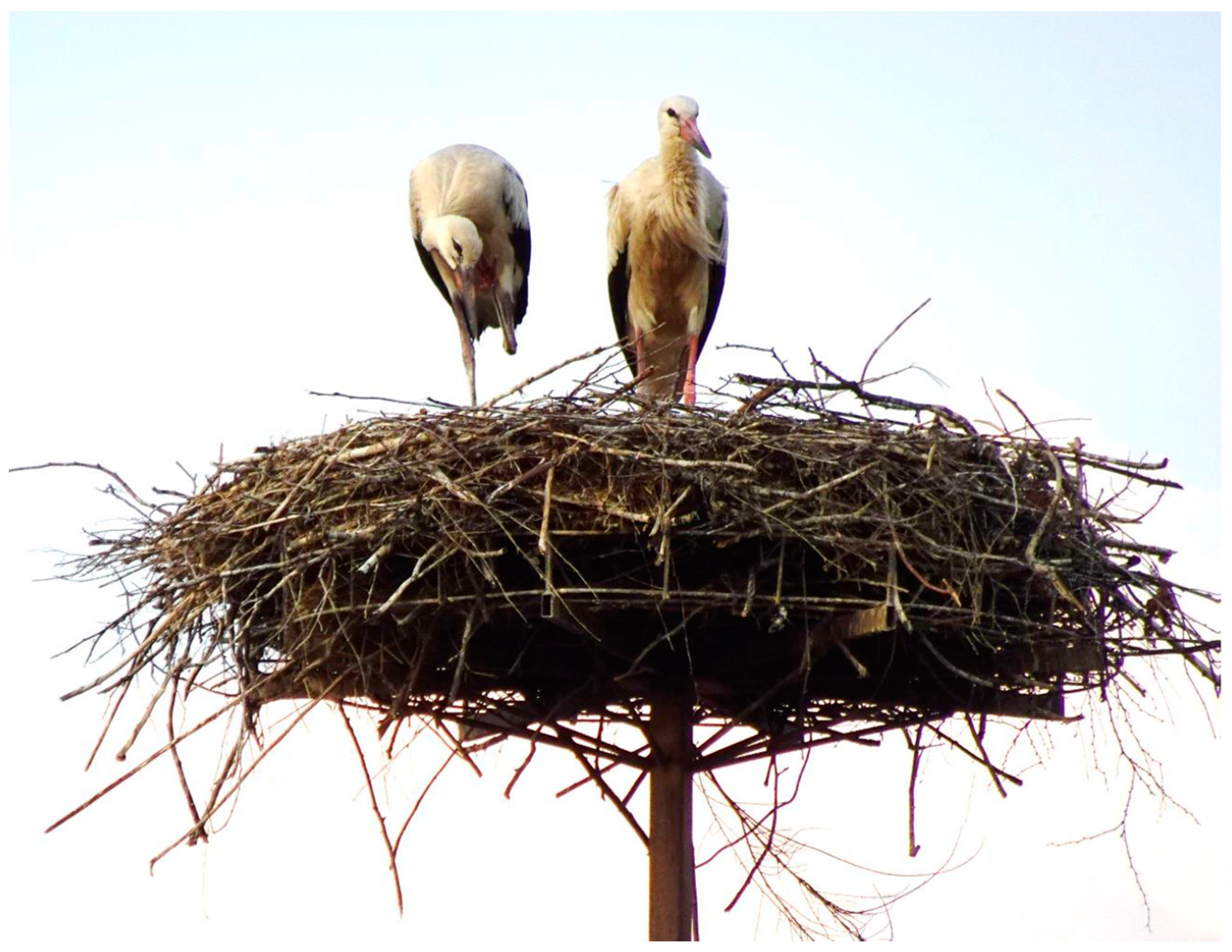
Figure 1. Young storks in a nest; photo: J. Bihałowicz.
Earth 05 00019 g001
Figure 2. Location of the study area in Poland.
Earth 05 00019 g002
Figure 3. Summary of data on nest occupancy in study area in Kampinos National Park. Panel (a) presents histogram of average nest occupancy in years 2006–2011; (b) for years 2012–2017; (c) [resents average occupation, year by year.
Earth 05 00019 g003
Figure 4. Land cover in the study area according to CLC 2018.
Earth 05 00019 g004
Figure 5. Share of individual land cover categories according to CORINE Land Cover in 2006 in the study area depending on the distance from white stork nests for 122 nests. The legend provides CORINE Land Cover codes: 112—discontinuous urban fabric, 121—industrial or commercial units, 122—road and rail networks and associated land, 123—port areas, 124—airports, 131—mineral extraction sites, 132—dump sites, 133—construction sites, 141—green urban areas, 142—sport and leisure facilities, 211—non-irrigated arable land, 222—fruit trees and berry plantations, 231—pastures, 242—complex cultivation patterns, 243—land principally occupied by agriculture, with significant areas of natural vegetation, 311—broad-leaved forest, 312—coniferous forest, 313—mixed forest, 324—transitional woodland/shrub, 411—inland marshes, 511—water courses, 512—water bodies.
Earth 05 00019 g005
Figure 6. Share of individual land cover categories according to CORINE Land Cover in 2012 in the study area depending on the distance from white stork nests for 122 nests. The legend provides CORINE Land Cover codes: 112—discontinuous urban fabric, 121—industrial or commercial units, 122—road and rail networks and associated land, 123—port areas, 124—airports, 131—mineral extraction sites, 132—dump sites, 133—construction sites, 141—green urban areas, 142—sport and leisure facilities, 211—non-irrigated arable land, 222—fruit trees and berry plantations, 231—pastures, 242—complex cultivation patterns, 243—land principally occupied by agriculture, with significant areas of natural vegetation, 311—broad-leaved forest, 312—coniferous forest, 313—mixed forest, 324—transitional woodland/shrub, 411—inland marshes, 511—water courses, 512—water bodies.
Earth 05 00019 g006
Figure 7. Share of individual land cover categories according to CORINE Land Cover in 2018 in the study area depending on the distance from white stork nests for 122 nests. The legend provides CORINE Land Cover codes: 112—discontinuous urban fabric, 121—industrial or commercial units, 122—road and rail networks and associated land, 123—port areas, 124—airports, 131—mineral extraction sites, 132—dump sites, 133—construction sites, 141—green urban areas, 142—sport and leisure facilities, 211—non-irrigated arable land, 222—fruit trees and berry plantations, 231—pastures, 242—complex cultivation patterns, 243—land principally occupied by agriculture, with significant areas of natural vegetation, 311—broad-leaved forest, 312—coniferous forest, 313—mixed forest, 324—transitional woodland/shrub, 411—inland marshes, 511—water courses, 512—water bodies.
Earth 05 00019 g007
Table 1. Summary of designations used in the white stork inventory along with “nest occupancy” values.
Parameter ValueCode from the InventoryExplanation
Nest unoccupied (0)HOThe nest remained unoccupied, and no storks were observed to have arrived.
HB1The nest was visited by a single stork for a period of one week to one month, or alternatively, was occupied intermittently during the breeding season.
HB2The nest was visited by two storks for a period of one to two weeks, or intermittently during the breeding season.
HBxThe nest was visited for a period of between one and two weeks, although the number of birds present at the time is unknown.
Nest occupied (1)HPThe nest was occupied by a pair of birds for a period of more than one month between the dates of 14 April and 15 June.
Table 2. CORINE Land Cover categories occurring in the study area.
LEVEL 1LEVEL 2LEVEL 3
CODENAMECODENAMECODENAME
1Artificial surfaces11Urban fabric112Discontinuous urban fabric
12Industrial, commercial, and transport units121Industrial or commercial units
122Road and rail networks and associated land
123Port areas
124Airports
13Mine, dump and construction sites131Mineral extraction sites
132Dump sites
133Construction sites
14Artificial, non-agricultural vegetated areas141Green urban areas
142Port and leisure facilities
2Agricultural areas21Arable land211Non-irrigated arable land
22Permanent crops222Fruit trees and berry plantations
23Pastures231Pastures
24Heterogeneous agricultural areas242Complex cultivation patterns
243Land principally occupied by agriculture, with significant areas of natural vegetation
3Forest and semi-natural areas31Forests311Broad-leaved forest
312Coniferous forest
313Mixed forest
32Scrub and/or herbaceous vegetation associations324Transitional woodland-shrub
4Wetlands41Inland wetlands411Inland marshes
5Reservoirs51Inland waters511Water courses
512Water bodies
Table 3. The following section presents the correlations between land cover categories according to level 1 of CORINE Land Cover and white stork nest occupancy in 2006–2012 and 2012–2018 depending on distance from nests for 122 nests. The statistical significance of these correlations was marked at numerical values with the following codes: ***—p < 0.001; **—p < 0.01; *—p < 0.05; tr (trend)—p < 0.1.
CLC
I
2006–20112012–2017
1 km2 km3 km4 km5 km1 km2 km3 km4 km5 km
1—Artificial surfaces−0.031−0.050−0.022−0.021−0.033−0.028−0.197 *−0.225 *−0.297 ***−0.313 ***
2—Agricultural areas0.169 ᵗʳ0.0980.0840.1140.157 ᵗʳ0.315 ***0.272 **0.201 *0.157 ᵗʳ0.114
3—Forest and semi-natural areas−0.177 ᵗʳ−0.116−0.097−0.121−0.155 ᵗʳ−0.309 ***−0.212 *−0.14−0.066−0.001
4—Wetlands 0.0600.0810.1010.127 0.0740.045−0.052−0.037
5—Water bodies0.0860.1120.0910.0860.0790.0280.0600.1000.1080.106
Table 4. Correlations between land cover categories according to level 2 of CORINE Land Cover and white stork nest occupancy in 2006–2012 and 2012–2018 depending on distance from nests for 122 nests presented in numerical form. The statistical significance of these correlations is indicated by the following codes: ***—p < 0.001; **—p < 0.01; *—p < 0.05; tr (trend)—p < 0.1.
CLC
II
2006–20112012–2017
1 km2 km3 km4 km5 km1 km2 km3 km4 km5 km
11—Urban fabric−0.043−0.057−0.022−0.02−0.0190.017−0.139−0.180 *−0.273 **−0.304 ***
12—Industrial, commercial, and transport units0.0510.0180.0210.004−0.073−0.251 **−0.336 ***−0.331 ***−0.313 ***−0.324 ***
13—Mines, dump sites, and construction sites0.070−0.029−0.105−0.106−0.104−0.028−0.015−0.004−0.034−0.043
14—Artificial, non-agricultural vegetated areas−0.184 *−0.0350.011−0.001−0.020−0.109−0.229 *−0.191 *−0.273 **−0.265 **
21—Arable land0.0970.1040.1000.0940.1120.245 **0.235 **0.159 ᵗʳ0.1050.074
22—Permanent crops 0.0520.0190.0160.039 0.047−0.022−0.0070.001
23—Pastures0.038−0.065−0.078−0.0290.022−0.075−0.055−0.044−0.034−0.021
24—Heterogeneous agricultural areas0.0380.0830.0830.1150.1380.1440.178 *0.198 *0.201 *0.153 ᵗʳ
31—Forests−0.148−0.070−0.060−0.095−0.127−0.338 ***−0.240 **−0.144−0.0610.010
32—Scrub and/or herbaceous vegetation associations−0.120−0.180 *−0.181 *−0.179 *−0.217 *−0.043−0.024−0.048−0.055−0.052
41—Inland wetlands 0.0600.0810.1010.127 0.0740.045−0.052−0.037
51—Inland waters0.0860.1120.0910.0860.0790.0280.0600.1000.1080.106
Table 5. The following table presents the correlations between land cover categories according to level 3 of CORINE Land Cover and white stork nest occupancy in 2006–2012 and 2012–2018, depending on distance from nests for 122 nests. The statistical significance of these correlations is indicated by the following codes: ***—p < 0.001; **—p < 0.01; *—p < 0.05; tr (trend)—p < 0.1.
CLC
III
2006–20112012–2017
1 km2 km3 km4 km5 km1 km2 km3 km4 km5 km
112—Discontinuous urban fabric−0.043−0.057−0.022−0.02−0.0190.017−0.139−0.180 *−0.273 **−0.304 ***
121—Industrial or commercial units0.0510.0180.0190.02−0.046−0.251 **−0.336 ***−0.339 ***−0.282 **−0.308 ***
122—Road and rail networks and associated land −0.038−0.039 −0.231 *−0.235 **
123—Port areas −0.126−0.088 0.0320.033
124—Airports 0.027−0.026−0.104 −0.240 **−0.328 ***−0.314 ***
131—Mineral extraction sites0.060−0.028−0.088−0.099−0.080−0.028−0.015−0.003−0.013−0.002
132—Dump sites 0.0600.060−0.024 −0.129−0.129−0.252 **
133—Construction sites0.060−0.010−0.055−0.057−0.086
141—Green urban areas 0.0570.0130.045 −0.124−0.264 **−0.262 **
142—Sport and leisure facilities−0.184 *−0.0350.003−0.006−0.047−0.109−0.229 *−0.190 *−0.257 **−0.250 **
211—Non-irrigated arable land0.0970.1040.1000.0940.1120.245 **0.235 **0.159 ᵗʳ0.1050.074
222—Fruit trees and berry plantations 0.0520.0190.0160.039 0.047−0.022−0.0070.001
231—Pastures0.038−0.065−0.078−0.0290.022−0.075−0.055−0.044−0.034−0.021
242—Complex cultivation patterns0.0480.0270.0220.0160.052−0.0410.0570.0890.0730.057
243—Land principally occupied by agriculture0.0130.0840.0920.1420.157 ᵗʳ0.179 *0.180 *0.202 *0.225 *0.176 ᵗʳ
with significant areas of natural vegetation−0.103−0.070−0.063−0.059−0.047−0.149−0.120−0.070−0.0190.020
311—Broad-leaved forest−0.152 ᵗʳ−0.044−0.031−0.072−0.146−0.326 ***−0.189 *−0.113−0.0540.003
312—Coniferous forest0.116−0.027−0.068−0.133−0.080−0.093−0.195 *−0.16 ᵗʳ−0.0960.002
313—Mixed forest−0.120−0.180 *−0.181 *−0.179 *−0.217 *−0.043−0.024−0.048−0.055−0.052
324—Transitional woodland/shrub 0.0600.0810.1010.127 0.0740.045−0.052−0.037
411—Inland marshes0.0780.1060.0870.0820.0740.0260.0640.1080.1100.107
511—Water courses0.0790.1100.0950.1270.1310.027−0.074−0.165 ᵗʳ−0.050−0.038
Disclaimer/Publisher’s Note: The statements, opinions and data contained in all publications are solely those of the individual author(s) and contributor(s) and not of MDPI and/or the editor(s). MDPI and/or the editor(s) disclaim responsibility for any injury to people or property resulting from any ideas, methods, instructions or products referred to in the content.