1. Introduction
The amount and complexity of information maintained according to the regulations of public authorities are constantly increasing [
1]. This process is conditioned by the development of technologies and is taking place alongside it. Adopting technological developments, especially in the area of information and communications technology (ICT), and their implementation in the system of registers, has enabled the easier maintenance, access and exchange of information. This has introduced the possibility of collecting new, additional information that was not gathered previously due to technical difficulties in their maintenance. Cadastral data are basic data for a land administration system [
2]. Their availability in digital form makes them interesting to an increasing number of new areas of human activity, for the further development of which they become essential. This in turn leads to a constant increase in demand for cadastral information. Therefore, countries must work on improving this information in order to maintain their development. In 2017, Vučić et al. described in detail the Croatian Land Administration System and analyzed the possibilities for its upgrade to 3D by existing data [
3]. Moreover, some authors from EU countries have described the processes associated with registering 3D property, such as underground tunnels in the Land Administration System [
4], and we present examples from Croatia in this paper.
The concept of disaster management represents a unique area of management. In this context, the traditional military sphere has moved into the civilian sphere, and is an integral part of the functioning of civil institutions, as risk and crisis (real or perceived) are an integral part of daily human life. Moreover, the importance of institutes for crisis management can be seen in the fact that many countries around the world have established special government agencies (for example, the US federal agency for crisis management / Federal Emergency Management Agency—
https://www.fema.gov/it)–accessed 28 October 2021, and some even ministries (the Russian Federation), with the aim of developing and integrating national capacity for effective crisis management.
A study of the earthquakes of magnitude 3.0 or above occurring during the period between 1980 and 2019 in California and Nevada [
5] provides a new perspective for the exploration of the temporal and spatial evolution trends of earthquakes and also for understanding the earthquake risk in this area. Tomar et al. [
6] recently conducted research that supports the notion that community development and advanced preparation strategies will help to deal effectively with wildfire incidents. They show how an adapted geospatial model was effectively employed in the development of management strategies for forest fire hazard in the Sirmaur district of the Himalayan provinces of India.
In the last ten years, there have been many natural disasters in Croatia:
The flood in the East Slavonia region, May 2014;
The forest fire on the Pelješac Peninsula and the island of Korčula, July 2015;
Earthquakes in 2020.
In addition, when Croatia became an independent country, there was a four-year war for independence (1991–1995). The Croatian War of Independence was fought from 1991 to 1995 between Croat forces loyal to the government of Croatia—which had declared independence from the Socialist Federal Republic of Yugoslavia—and the Serb-controlled Yugoslav People’s Army (JNA) and local Serb forces. During this war, there were approximately 22,000 human casualties. In addition, 183,526 residential buildings were damaged or destroyed.
The objective of this paper is to show that the use of official geodata is the most reliable and useful means in disaster prevention as well as in disaster recovery. However, in combination with other data sources (e.g., private sector and citizens), official geodata could become even more useful.
Geodata are, without a doubt, crucial in disaster management. In essence, every phase of disaster risk management (DRM) relies on geodata. They can be provided by many different sources but official geodata are often the most reliable source. By official geodata, we refer to geodata that are produced under a competent and responsible authority. These are known as National Mapping and Cadastral Authorities (NMCAs). In Croatia, the State Geodetic Administration acts as an NMCA. The official NMCA products usually include:
The paper is organized as follows.
Section 2 describes the definition and disaster management phases.
Section 3 presents examples of hazardous situations that occurred in Croatia in the last few decades and the role of the NMCA. The paper ends with a discussion.
2. Methods
A disaster can arise from natural- and/or human-caused unforeseen events, resulting in health, social, economic and environmental impacts.
The United Nations Office for Disaster Risk Reduction (UNDRR) defines disaster as a serious disruption of the functioning of a community or a society involving widespread human, material, economic or environmental losses and impacts, which exceeds the ability of the affected community or society to cope using its own resources [
7]. According to the International Federation of Red Cross and Red Crescent Societies, a disaster is a combination of hazard, vulnerability and the capacity of society to cope with the negative consequences of hazard events.
A hazard involves any activity or condition that can have an undesirable outcome for living beings, along with economic, social and environmental aspects. There are different source types that can give rise to a hazard, such as geological, meteorological, hydrological, oceanic, biological and technological. Multiple sources and their combinations can trigger a hazard as well.
Vulnerability arises from different physical, social, economic and environmental factors, and represents a decreased capacity to cope with, resist and recover from a hazard. It is often associated with poverty, a lack of information and limited recognition of risks by an individual or a group, poor workmanship in construction and asset protection.
Natural disasters are adverse events resulting from natural hazards, with consequences that have an impact on three major aspects: humans, property and the environment. Due to climate change, global human population growth and rapid economic and technological development, the number of natural disasters has been increasing over the last ten years. Earthquakes and floods are the most common natural hazards, followed by landslides, storms, tsunamis, avalanches and fires. Disasters caused by humans are damaging events resulting from human negligence or intention, as well as failures occurring within systems created by humans. Such disasters can also lead to loss of life and damage to buildings or infrastructure.
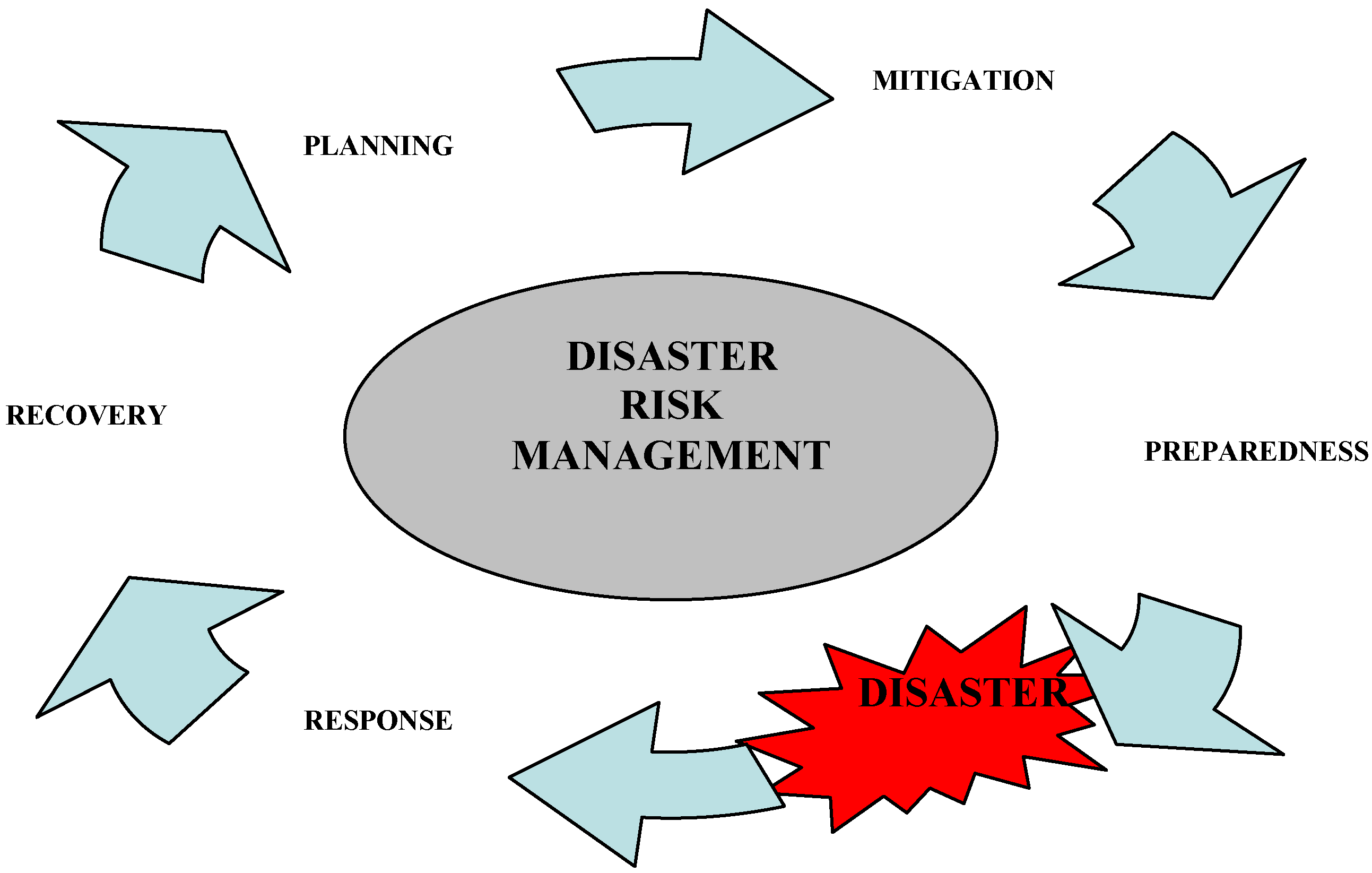
Efficient DRM associated with hazards starts with the identification of vulnerabilities. In general, DRM consists of several phases (
Figure 1). Each of these phases comes with its own tasks and has to be carefully planned and well-organized in order to react in a timely and appropriate manner [
8].
Planning includes required actions for the analysis and reporting of possible disasters and potential outcomes or impacts on human lives, material assets and the natural environment. Here, geodata serve as a basis for planning activities.
Mitigation involves actions that decrease or eliminate completely the probability of a disaster (e.g., legislation that includes special building requirements in earthquake-prone areas). In cases of inevitable disaster, mitigation also includes long-term actions especially developed to decrease the consequences of a disaster (e.g., usage of land management, emergency management based on forest removal in fire-prone areas or building restrictions in flood zones). Here, geodata provide a basis for mitigation measures. For example, seismic maps define areas with a high risk of earthquakes. In these areas, specific requirements should be followed for construction works.
Preparedness serves as an additional measure where mitigation actions and measures cannot prevent disasters. In the preparedness phase, in order to save lives and reduce damage, governmental institutions, special organizations and individuals create action plans, involving the implementation of early warning systems or preparing emergency responders. Geodata are, again, very important here, especially sensor data, which are collected 24/7 in early warning systems. They typically include GNSS data for the monitoring of movements (landslides, construction, etc.) but also other geodata, e.g., in oceans to monitor tsunamis, etc.
Response actions follow an emergency or disaster. Such actions include help and support for victims in the areas affected by the disaster in terms of search and rescue, providing shelter and medical care. Response actions seek to normalize the situation in order to avoid secondary damage. Here, dynamic geodata are crucial. These could be satellite images acquired immediately after the disaster that show the affected area, which could be used to detect clear roads or flooded areas, etc.
The objective of recovery is to return all systems to a previous, normal or better state, with the following actions: short-term actions with the goal of returning the main life support systems to minimum operating standards, and long-term actions with the goal of returning life to normal or improved levels, which may continue for several years after the disaster occurs. Here, geodata, especially cadastral and 3D data, are the ultimate source for the reconstruction of damaged buildings and other constructions.
There are many sources of geodata available today, from the official data, produced mostly by public authorities, to private and volunteer data. However, in the case of disasters, the most relevant and reliable geodata for recovery tend to be those from official sources.
The SGA produces different official datasets that are important in the pre-disaster phase but also afterwards in the recovery phase.
3. Case Studies and Results
The main periodically recurrent natural hazards in Croatia are floods and fire hazards. With smaller or greater devastating consequences, they occur every year, keeping the state and local government alert and forcing them to be proactive. Recently, earthquakes again became the focus. In the recent past, Croatia also experienced a period of war. Croatia’s demographic losses during the War of Independence are a significant factor affecting contemporary population development tendencies, especially in the emergence and intensification of the natural and total depopulation processes [
9]. This section will give a brief overview of the disasters faced by Croatian citizens in the last 30 years and show how official geodata (independently or combined with other data) can help in DRM before and after disaster events. Due to the fact that human life is priceless, for any kind of disaster, it is necessary to devise a plan in order to avoid or minimize human casualties.
3.1. Flood Hazards
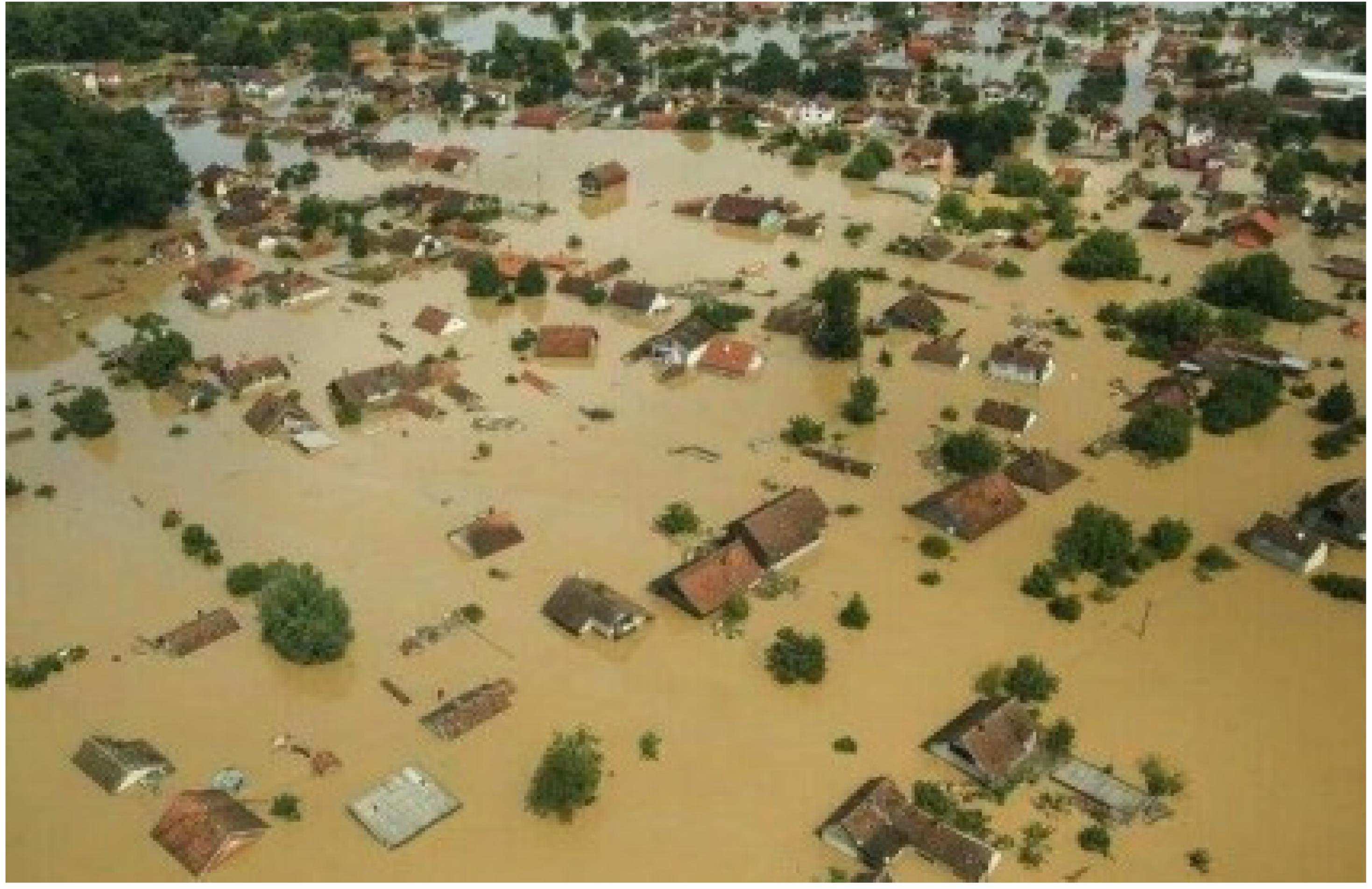
In May 2014, the worst flooding event in recent Croatian history caused thousands of people to flee from their homes and villages (
Figure 2) in the area of East Slavonia [
10].
In accordance with the EU INSPIRE Directive (2007/2/EC) and the National Spatial Data Infrastructure Act, Croatia established a National Spatial Data Infrastructure (NSDI) geoportal [
11]. The SGA geoportal is available through the NSDI geoportal and also as a standalone portal [
12]. The SGA geoportal is equipped with all the necessary functionalities for the establishment of a metadata service, as well as for the usage of the SGA spatial databases [
13]. It provides all official geodata and can assist in the better maintenance of geodata and also spatial monitoring. The SGA acts as the national contact point for INSPIRE and facilitates the discoverability and accessibility of other geodata from public sectors that fall within the scope of the INSPIRE Directive.
The SGA geoportal provides the following sets of data:
1:5000 digital orthophoto map (Geoportal basis), recorded and produced during 2011;
Croatian Base Map 1:5000 (topographic);
Topographic Map 1:25,000;
Digital cadastral map (cadastral offices, cadastral municipality, cadastral parcels, buildings, house numbers);
Central Registry of Spatial Units (counties, cities and municipalities, towns, local government);
Generalized content 1:100,000 topographic map (roads, railways, ferry piers, lakes and waterways).
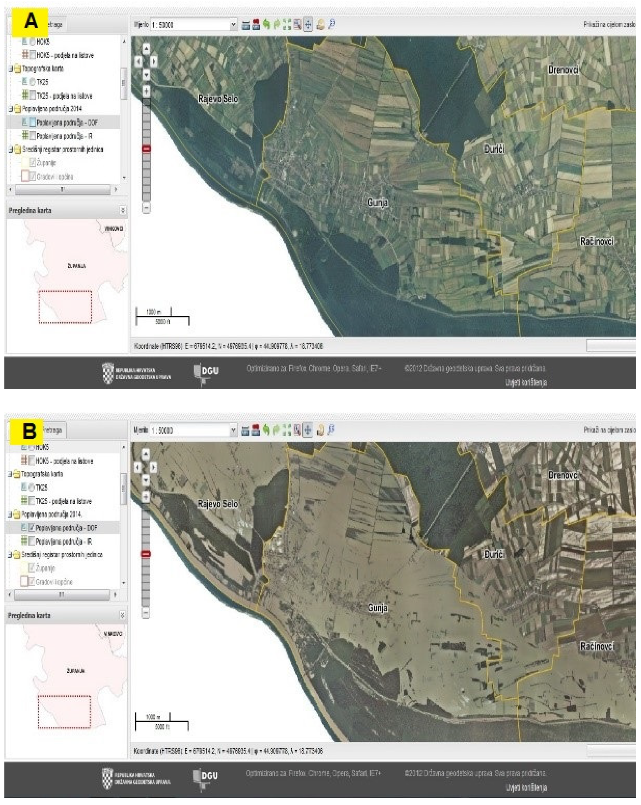
In the wake of the floods in Eastern Slavonia in 2014, the SGA prepared digital orthophoto maps of the flooded areas immediately after the disaster. These maps were used for the repair of agricultural damage and the recovery of flooded residential and farm buildings. The following figure represents the digital orthophoto maps of the villages Gunja, Rajevo Selo and Račinovci before and after the East Slavonia 2014 flood, available through the SGA geoportal (
Figure 3). Such a disaster of unprecedented proportions in Croatia brought immense material damage and a few human casualties.
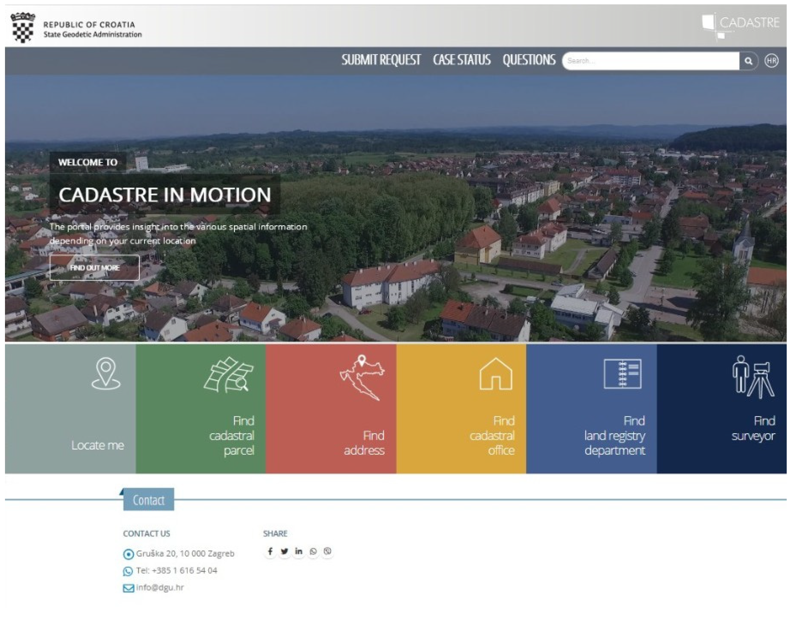
In such situations, the SGA’s official data can be used to search for survivors and potential victims during floods, where data such as the height, number of floors and layout of buildings could be of great importance. Moreover, since 2019, the SGA Cadastre in Motion has been available.
The Cadastre in Motion (
Figure 4) is an interactive web application [
14] that provides cadastral parcel data, a register of spatial unit data and also ownership data, on different devices. It can be used on smartphones to locate accurate positions in the field and access different sets of data from the abovementioned registers in real time, which is very useful in crisis situations.
The user can simply use the Locate me option, which will detect the user’s location and offer different services based on this. These include the identification of the cadastral parcel (its number and cadastral municipality), address, nearest cadastral office and land registry office, nearest licensed surveyor, geographical names and geodetic reference points. Data about the cadastral parcel also provide information on land use, buildings, owner and area.
Although Cadastre in Motion was not developed primarily for use in disaster risk management, it is clear that, in such situations, it can be utilized to its maximum effect.
3.2. Earthquakes
Although earthquakes in the region of Croatia have been recorded many times throughout history, the earthquakes that struck the cities of Zagreb [
15], Petrinja, Glina, Sisak [
16,
17] and the surrounding areas in 2020 took many by surprise. The current generations of people living in this area had not previously faced so many tremors over a prolonged period of time, and the destruction caused by this type of natural hazard was widespread.
3.2.1. Description of the Events
An earthquake with a magnitude of 5.5 on the Richter scale occurred in Zagreb on Sunday, 22 March 2020 at 6:24 AM. The European Mediterranean Seismological Center reported that the epicenter was located 7 km north of the center of Zagreb (Markuševec) at a depth of 10 km. Another earthquake measuring 5.0 on the Richter scale followed at 7:01 AM, and the third earthquake was recorded at 7:41 AM, measuring 3.7 on the Richter scale. Within slightly over 24 h after the first earthquake, 57 additional earthquakes were recorded in the city of Zagreb, and, according to the Seismological Service and the European Mediterranean Seismological Center, the strongest was 5.5 and the weakest 2.0 on the Richter scale. The Seismological Service announced that by 14 April, approximately 145 earthquakes had been recorded, which were noticed by the citizens, with magnitudes above 1.3 on the Richter scale. The seismographs recorded another 850 earthquakes of magnitude less than 1.3. In the city of Zagreb, a total of 27 people were injured in the earthquakes, while one person died from injuries.
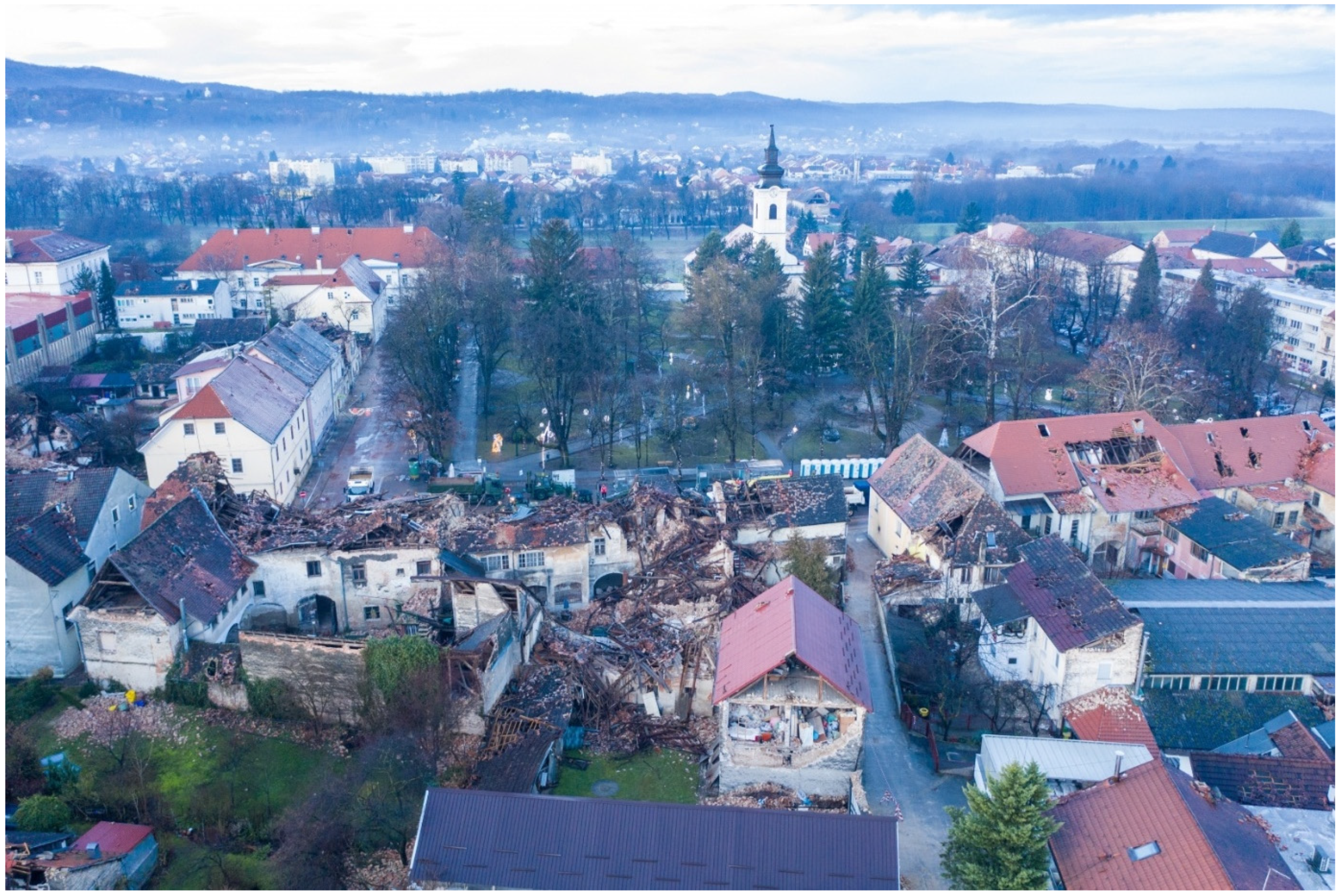
The earthquake near Petrinja occurred on 29 December 2020 at 12:20 CET and had a level VIII of intensity on the Mercalli scale or a magnitude of 6.4 on the Richter scale. It was preceded by several minor earthquakes but also an earthquake with a magnitude of 5.2 on the Richter scale on the previous day. The earthquake caused casualties and huge material damage in Petrinja, but also in the nearby cities of Glina, Sisak and Zagreb. Seven people died and at least 26 others were injured, six of whom sustained serious injuries. The initial reports showed that numerous buildings were destroyed in Petrinja (
Figure 5). The quake was felt throughout Northern Croatia, as well as in large parts of Slovenia, Bosnia and Herzegovina, Serbia, Austria, Hungary, Slovakia and Italy.
Based on the data of the Croatian Center for Earthquake Engineering, collected on 4 February 2021, the situation in the earthquake-affected city of Petrinja and Glina is shown in the following graph (
Figure 6).
3.2.2. GNSS and Earthquakes
The usage of GNNS in the case of earthquakes is not new. Murai and Araki [
18] patented the detection of GNSS signals before an earthquake by means of computing the changes in the triangular areas that have GNSS stations at their vertices. For 162 earthquakes in Japan that were larger than 6.0 in magnitude on the Richter’s scale, the preceding GNSS signal was received between one and ninety days prior to the earthquake [
19]. Following the example of Japan, for Croatia, Prof. Nikola Solarić and Prof. Miljenko Solarić suggested that it would be possible to also use the GNSS stations from CROPOS in geodynamics, as well as in seismology. The Croatian Positioning System (CROPOS) is a reference GNSS network of permanent stations in Croatia, enabling its users to determine their coordinates with the GNSS technology in real time, with accuracy of 2 cm (horizontally) and 4 cm (vertically) for the entirety of Croatia [
20]. Currently, CROPOS is mostly used for the maintenance and development of the cadaster.
It is furthermore suggested [
19] that 10 new well-stabilized GNSS stations should be set up in Zagreb and its surrounding areas. This method should be combined with other available geophysical methods. The final decision regarding the announcement of the preceding GNSS signal before earthquake would be given by seismotectonic experts. The movement of permanent stations can be monitored to possibly predict earthquakes. Cadastral data and orthophotos can be used to plan and determine the appropriate routes for possible earthquake risk.
By analyzing the 24-hour GNSS measurements of the CROPOS reference points according to the method of differences in daily distances between the stations, it was proven that, two days before the recent earthquakes in Croatia, there was a shortening of the distance between the reference points. In other words, there was compression in the Earth’s crust. This compression was already shown in the analysis of GNSS measurements between the points of positional systems in the cases of four previous earthquakes—at Kraljevo (2010), Drežnica (Senj, 2013), Skopje (2016) and near Zagreb (2018)—as well as with the most recent earthquakes in Zagreb in 2020 [
21].
3.2.3. SGA’s Response
In the period from 4 to 28 January 2021 in the earthquake-affected area, officials of the SGA performed preparatory work and precise GNSS measurements in the area of the cities of Petrinja, Glina and Sisak. For the purpose of determining ground displacement in the earthquake-affected area, a control measurement of homogeneous fields of permanent points of the geodetic basis was performed. Along with the points of homogeneous fields, in a wider epicentral area (10–15 km), measurements were also performed at the points of the GNSS network of the second order and at the trigonometric points. There was a total of 84 points. Measurements were performed by three field teams using the high-precision positioning service CROPOS VPPS. The coordinates of the measured points were determined in the official HTRS96/TM positional reference system and the official HVRS71 height reference system. Based on the obtained results, the analysis of displacements at the permanent points of the geodetic basis was conducted (
Figure 7).
By analyzing the coordinates of permanent points of the geodetic basis before and after the earthquake, it was determined that the greatest displacement was at the points in the area of the homogeneous field of Petrinja, with mean values of displacement of 45 cm in the southeast direction. The mean value of displacement for the homogeneous field of Glina was 10 cm in the northwest direction, and it was 10 cm to the east for the area of the homogeneous field of Sisak. Moreover, the altitude offset of 10 cm was determined (soil descent) for the area of the homogeneous field of Glina [
22].
These are the first official results published by the SGA where the results of the analysis were obtained by precise GNSS measurements, and they are, along with the visible outcome of the earthquake, an indication of the strength of the earthquakes and their impact on the Earth’s crust and the connecting structures. The measurements show that shifts occurred in all three dimensions, and it has been determined that it is necessary to eliminate the consequences of the earthquake on the geodetic cadastral system, which is one of the prerequisites for easier reconstruction. In May 2021, the SGA began work to eliminate the consequences of the earthquake on the geodetic and cadastral system.
The measurements performed so far, their results and their indicators are only the beginning of extensive geodetic works and activities that need to be performed. Given the complexity of these activities, the SGA will also collaborate with the scientific community, primarily with the Faculty of Geodesy, University of Zagreb, as well as with the Croatian Chamber of Chartered Geodetic Engineers. Together, they will devote efforts to the adoption of a workflow of activities in order to eliminate the effects of the catastrophic earthquakes, based on the official data of a state survey, as well as the official cadastral data. The workflow of activities will include all necessary activities, as well as deadlines for their implementation, in order to satisfy the preconditions for their smooth implementation during the first post-earthquake renewals, and especially to enable registration of the renewed buildings on the official registers.
The SGA will perform additional detailed analyses for the purpose of creating mathematical models and calculating transformation parameters that will correlate the existing cadastral data with the earthquake shifts depending on the earthquake epicenter distances and the established directions and values of the Earth’s crust displacement. After the calculations, this will enable unobstructed work by geodetic experts on the maintenance of the cadastral data in accordance with the regulations for which the SGA is responsible. The SGA will also perform new measurements at all permanent points of the geodetic basis, which will form the basis of all future surveys. In cooperation with the Ministry of Justice and Administration, the SGA will initiate new cadastral surveys for the areas of the city of Petrinja and its surroundings (11 cadastral municipalities), through which the reconstruction activities in Petrinja will also be monitored, and this will ultimately enable the comprehensive and economic reconstruction of the most affected areas [
22].
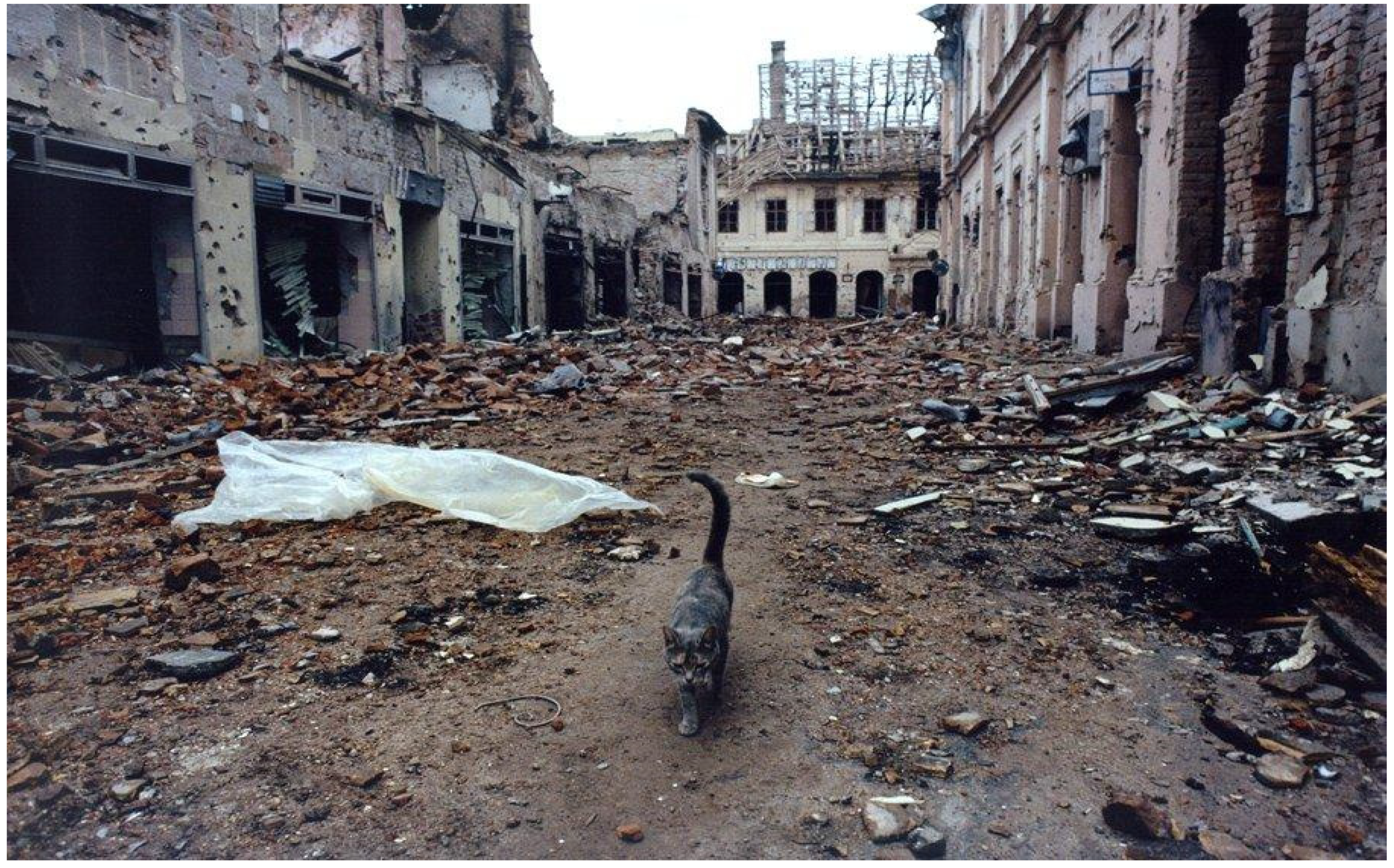
3.3. War Devastation
The Croatian War of Independence took place between 1991 and 1995, during which 22,000 human lives were lost and 183,526 residential buildings were damaged or destroyed (
Figure 8).
After the war, the reconstruction of residential, commercial and industrial facilities was inevitable. Registration in the cadaster and/or land register is important as it provides evidence of the existence of a building before its destruction or demolition. In order to determine the reconstruction rights for an object destroyed in war, evidence of the object’s (building or other structure) enrolment in the cadaster and/or land register must be delivered to the Croatian system of land management.
All buildings and other constructions that have been destroyed or rendered inaccessible due to natural disaster, war or other destruction, action or event are considered for reconstruction based on a valid building permit. The certificate that proves this fact must be issued by the relevant authority [
23].
Official geodata kept and maintained by the SGA were crucial in the reconstruction after the war. In particular, cadastral data, as well as aerial images taken before 1991, were used heavily in the reconstruction. Unfortunately, at that time, 3D information about the buildings was poor or missing, which is the reason that the SGA is currently working on the establishment of a building register. This will serve for real estate management, valuation and marketing, but also as an important source of information to support disaster risk management.
3.4. Fire Hazards
During the summer period, fire hazards represent an especially severe threat, not only for vegetation and animals, but also for material resources and human lives. In Croatia, the most affected areas are those in the coastal region, which are characterized by a very dry environment and strong winds, which are conducive to the rapid spread of wildfire [
24]. In recent research on the Croatian territory, some solutions have been provided regarding the determination of hazard compensations based on land administration data.
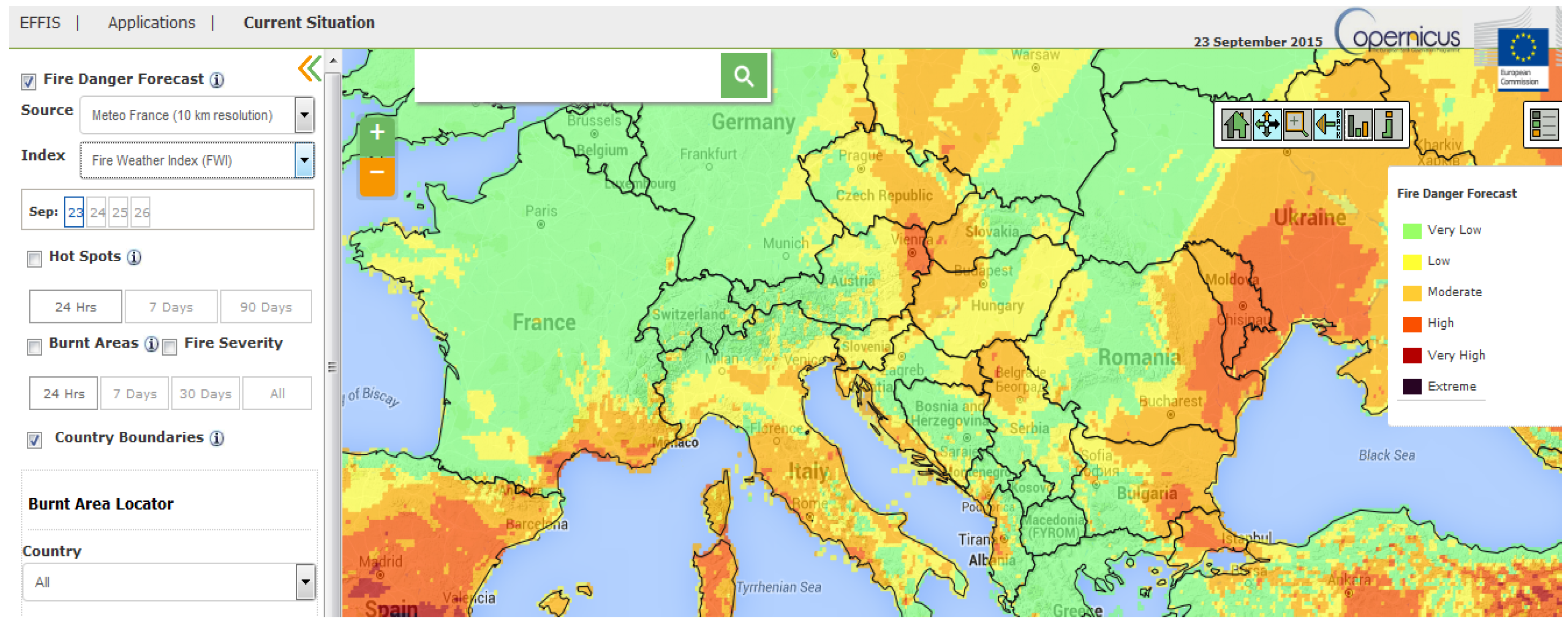
The European Forest Fire Information System (EFFIS) supports the services in charge of the protection of forests against fires in the European Union countries [
25] and provides the European Commission services and the European Parliament with updated and reliable information on wildland fires in Europe (
Figure 9). Temperatures higher than the normal monthly average, as well as lower average precipitation values, have contributed to the outbreak of several fires in Croatia. On the island of Korčula, a fire started near the village of Smokvica, in the afternoon of 18 July 2015. As of 22 July 2015, the EFFIS was still detecting hotspots. On the peninsula of Pelješac, a fire that started near the villages of Trstenik and Pijavičino on 20 July 2015 caused the evacuation of some citizens in the surrounding area. The fire affected a wide area on the peninsula, causing electricity cuts that extended to its largest town, Orebić. The fire burned some houses, but there were no human casualties. The EFFIS was still detecting hotspots on 21 July 2015. As of 21 July, the EFFIS calculations, based on satellite observations, indicated a combined affected area of over 1600 ha in the country of Dubrovačko-Neretvanska.
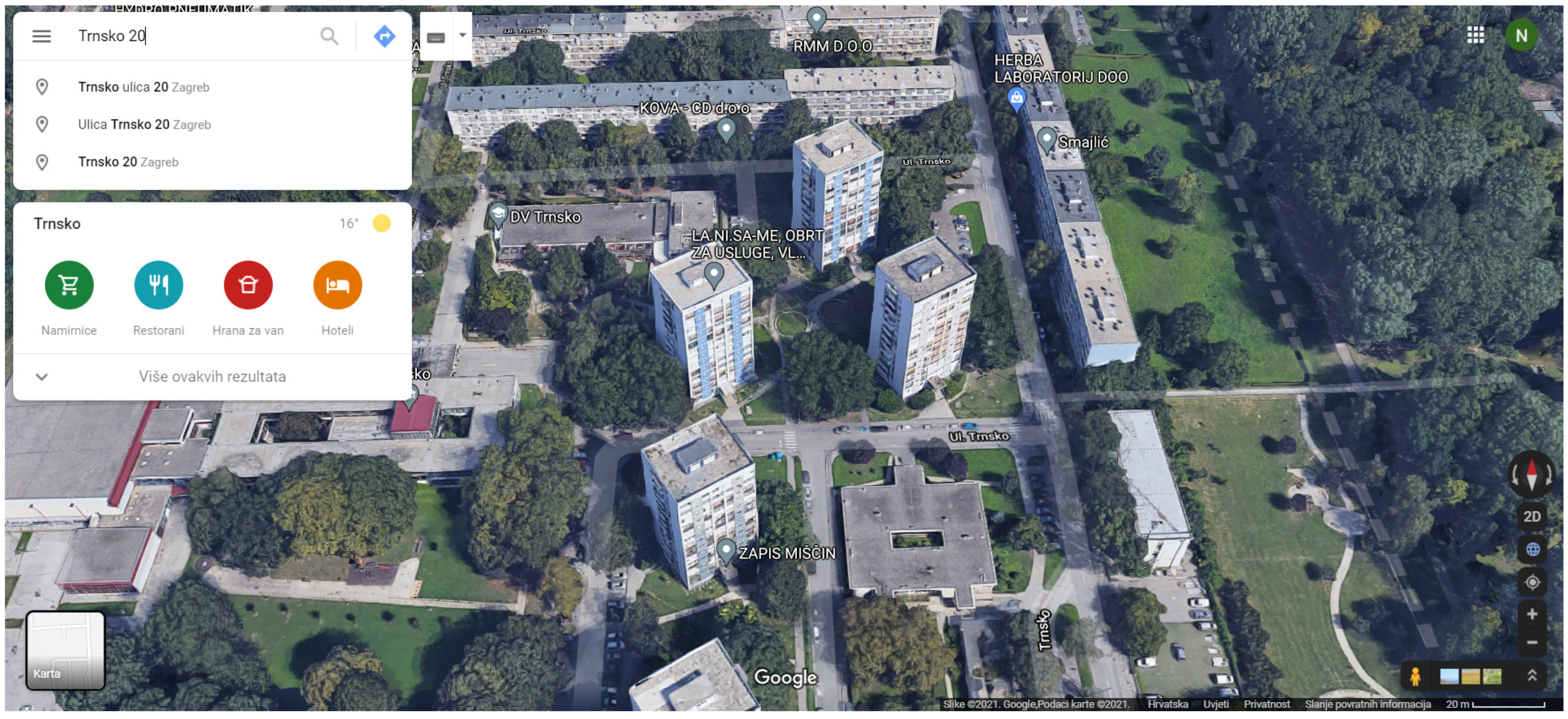
While preparing this paper (on 8 July 2021), a fire broke out in Zagreb, in the Trnsko neighborhood, on the ninth floor of an apartment building (
Figure 10). The fire was quickly extinguished, without casualties.
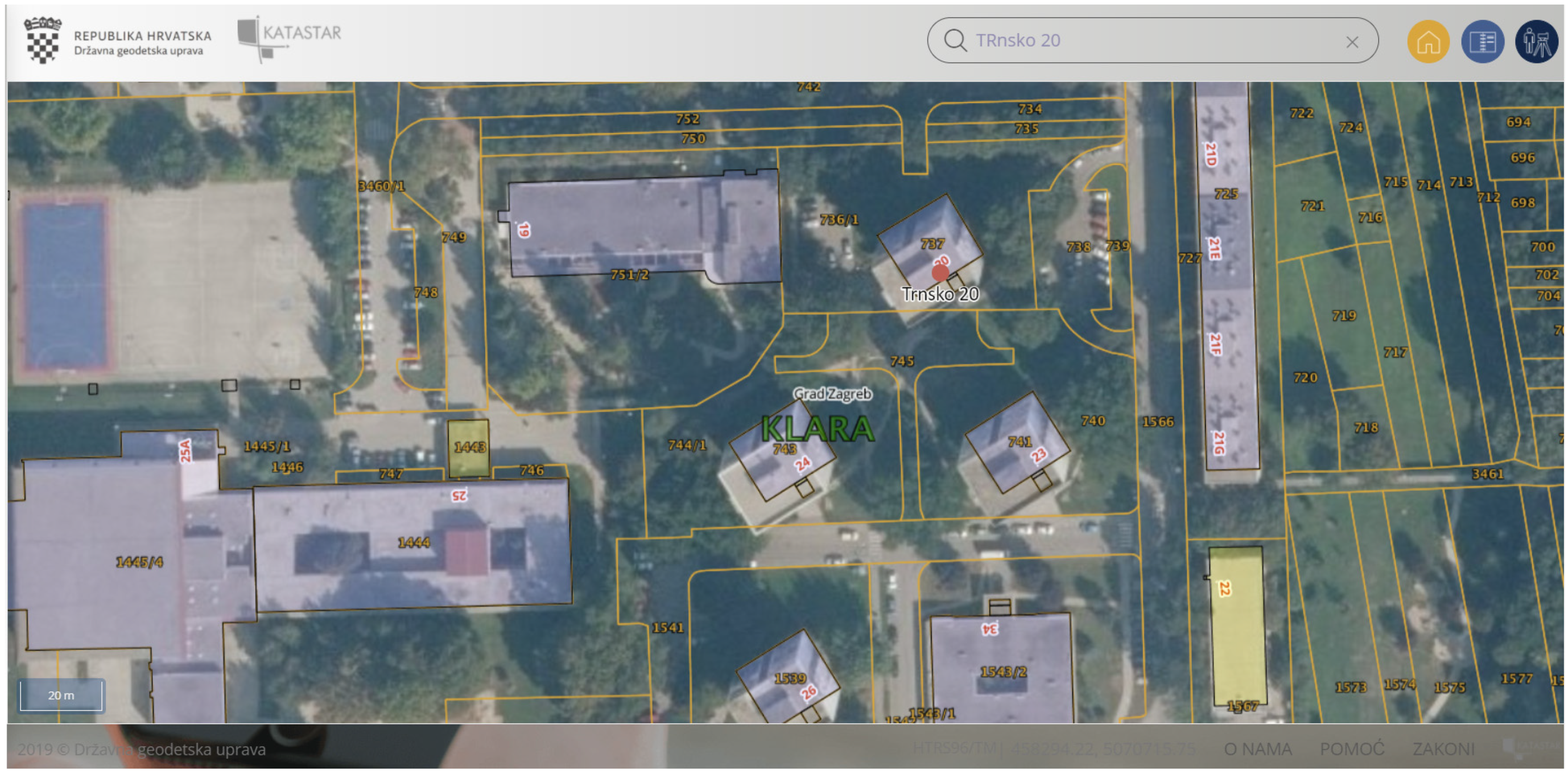
In large cities in the European Union, a 3D view of settlements is available that can help in crisis situations. This is a useful combination of land administrations, where the two most used systems help firefighters (
Figure 11). The Cadastre in Motion portal is connected with the Google Maps service and provides solid information about buildings in crisis. In some countries, the Google Maps service contains the Google Street View service, which is very useful in the domain of the 3D cadaster. This clearly shows the importance of the integration of official geodata with other sources (in this case, the private sector), which brings benefits for all.
Google Street View can be accessed through the Cadastre in Motion service, which contains data on addresses, cadastral parcels, land use, building use and real property owners (
Figure 12). Combining the worldwide Google service and local (state-owned) official register data, the fire department was able to collect useful information in a quick and efficient manner.
4. Discussion and Ways Forward
Geodata are nowadays collected through different sensors and by different stakeholders, including the public sector, private sector and citizens. Geodata collected by a competent public authority in charge (i.e., NMCAs) are considered to be official geodata. These data are often the most reliable and their usage is often prescribed by law in different areas. The NMCA’s geodata have already been demonstrated to be an adequate source of data for many tasks. However, they should be better organized, up-to-date, coherent and well-connected. In recent years, much effort has been devoted to scientific activities as well as practical implementation to bring the NMCA’s geodata to this higher level of functioning. However, the availability of other geodata sources within the private sector or among citizens (e.g., volunteer geodata) offers a strong alternative to official geodata. In order to maintain their relevance in society, NMCAs must change their approach and business model in such a way as to become more dynamic and to fulfil the increasing demands of users. One possible area is DRM. Official geodata such as the real property cadaster, utility cadaster and orthophotos were not created initially for this purpose, but the case studies provided in this paper undoubtedly show the usefulness and importance of the official geodata. In principle, the usage of geodata for DRM is not regulated by law. Therefore, all relevant geodata can be used from different available sources, even those from social networks (e.g., Twitter, Facebook). The most important criteria are their accuracy, reliability and real-time availability. In order to be well-prepared and react as quickly as possible, it is necessary to be on standby, even when the risk is not at a critical level. Hence, the area of DRM could represent a great opportunity on which NMCAs should be more focused in the future.
The Croatian SGA has standard geodetic–cadastral and cartographic data, as in most other EU countries. The accuracy of these data varies and mostly depends on the period in which the data were produced. For some parts of Croatia, official cadastral data originate from the 19th century. For other parts, new official cadastral data have been produced, which are characterized by modern survey techniques. From the use cases presented in this paper, it is clear that official geodata in combination with other data sources are generally sufficient to deal with the consequences of disasters but are also applicable in the prevention of disasters.
In order to be more competitive compared to other geodata sources, NMCAs should improve their traditional products. This could be accomplished by providing data through services and APIs. The services should be also dynamic, e.g., by transforming the static cadastral maps to online dynamic maps and allowing other data, from private companies and citizens, to be added and combined as needed. Adding the 3D information to the standard 2D, to create a 3D cadaster, will offer additional value to users and will create a principal tool not only for real property management and spatial planning, but also for DRM. The creation and provision of orthophotos on an ad hoc basis in the case of disasters (e.g., floods, forest fires) is another means of improving the standard offer through new services. The utility cadaster or cadaster of infrastructure should be updated and maintained online. Moreover, the network of GNSS reference stations can be better used and densified in seismically active areas to monitor ground movements and provide relevant data to early warning systems. The examples provided in this paper regarding the SGA’s services in Croatia clearly show that this is possible.


