Proceeding Paper

A Theoretical Framework for Multi-Hazard Risk Mapping on Agricultural Areas Considering Artificial Intelligence, IoT, and Climate Change Scenarios †

by
Roberto F. Silva
1,*,
Maria C. Fava
2,
Antonio M. Saraiva
3,
Eduardo M. Mendiondo
4,
Carlos E. Cugnasca
3 and
Alexandre C. B. Delbem
5
1
Institute of Advanced Studies (IEA), University of São Paulo (USP), Sao Paulo 05508-060, Brazil
2
Institute of Exact and Technological Sciences (IEP), Federal University of Viçosa (UFV), Rio Paranaiba 38810-000, Brazil
3
Polytechnic School, University of São Paulo (USP), Sao Paulo 05508-010, Brazil
4
São Carlos School of Engineering (EESC), University of São Paulo (USP), Sao Carlos 13566-590, Brazil
5
Institute of Mathematics and Computer Sciences (ICMC), University of São Paulo (USP), Sao Carlos 13566-590; Brazil
*
Author to whom correspondence should be addressed.
Presented at the 13th EFITA International Conference, online, 25–26 May 2021.
Eng. Proc. 2021, 9(1), 39; https://doi.org/10.3390/engproc2021009039
Published: 31 December 2021
(This article belongs to the Proceedings of The 13th EFITA International Conference)

Abstract

:
This work proposes a data-driven theoretical framework for addressing: (i) extreme climate events prediction through multi-hazard risk mapping using remote sensing, artificial intelligence, and hydrological models, considering multiple hazards; and (ii) environmental monitoring using on-site data collection and IoT technologies. The framework considers the possibility of evaluating multiple climate change scenarios for improving decision-making in terms of Government policies and farm planning. Its main requirements are gathered based on a literature review. Several essential metrics that can be evaluated, considering both supervised and unsupervised metrics and key performance indicators considering the triple bottom line aspects, are also proposed. The framework also adopts multi-hazard (considering several hazards) and multi-risk (considering several relevant stakeholders) aspects and can be used to simulate different scenarios, an essential task for improving decision-making.

1. Introduction

A critical impact of global warming was the increase in the occurrence and impact of extreme climate events, such as floods, droughts, heatwaves, cyclones, among others [1,2,3,4,5]. In this work, these are referred to as hazards. The major impacts of those hazards in agricultural areas are: crop losses, crop quality losses, environmental damage, soil nutrients loss, economic impacts, impacts on machinery and buildings, and social impacts [1,2,3,4,5]. Therefore, it is possible to observe that the three pillars of sustainability (economic, environmental, and social) are impacted by those hazards [4,5].
As observed in the surveys by [6,7,8], most of the works on the impacts of natural hazards present the following aspects: (i) evaluation of the potential impact of only one hazard; (ii) focus on urban environments; and (iii) focus on specific periods, not considering real-time monitoring. Additionally, it can be observed that only a few models in the literature consider the use of Internet of Things (IoT) technologies for real-time monitoring of the occurrence of those hazards in agricultural environments. Lastly, it is crucial to observe that most works in the literature focus only on the economic impacts of climate change. These models and frameworks do not explicitly consider the potential environmental damages and social effects of those hazards. The works by [6,7,8] are very relevant for multi-hazard risk analysis, a task that can be characterized as predicting and evaluating the potential impact of different types of hazards at a specific location [6,7,8]. This task is also referred to as event forecasting. However, those works do not consider the use of IoT technologies for real-time environmental monitoring, also referred to as ecosystem monitoring.
This work proposes a data-driven framework for multi-hazard risk mapping with a modular approach to address the following aspects: (i) domain-specific requirements of the agricultural domain; (ii) the three pillars of sustainability; (iii) both event prediction and ecosystem monitoring tasks; (iv) use of hazard-specific and general climate heterogeneous data; (v) use of hydrological and artificial intelligence (AI) models; (vi) considering different climate change scenarios; and (vii) generation of risk maps that can be used by stakeholders for decision-making. It is important to note that the results of the framework implementation can be helpful for several supply chain actors, such as the farmers, banks, traders, industries, logistics operations providers, and Government agencies. In addition, this work presents the main requirements gathered considering the two most critical hazards for sustainable agriculture (droughts and floods). Finally, it is vital to observe that the framework proposed considers the possibility of stakeholder interaction on several components to provide essential feedback loops and improve the models’ predictions and the risk maps generated.

2. Methodology

The methodology used in this paper was composed of 4 main steps:
1. Requirements gathering, considering an in-depth review of the literature to identify the main functional, non-functional, and domain-specific requirements for developing a multi-hazard risk framework for agricultural areas; 2. Identification of state-of-the-art models in the literature, focusing on multi-hazard risks; 3. Evaluation of the selected models, considering fulfillment of the identified requirements; 4. Framework proposal, considering the following aspects: models used, main inputs, data lifecycle stages, different climate change scenarios, a focus on agricultural areas and problems, and considering heterogeneous data, event prediction and ecosystem monitoring tasks.

3. Identified Requirements for Developing a Multi-Hazard Risk Framework for Agricultural Areas

It is important to note that most of the requirements identified in the literature are specific to the agricultural domain. This justifies the development of a framework for multi-hazard risk mapping specific to agricultural areas and their potential problems related to extreme climate events. The nine main requirements identified, based on the works by [4,5,6,8,9,10,11], were:
1. Considering multiple hazards and stakeholders; 2. Incorporating data from multiple sources (news, images, sensors, and stakeholders participation); 3. Predicting events and monitoring the environment in real-time; 4. Considering different climate change scenarios; 5. Allowing for probabilistic predictions due to the stochastic nature of the extreme events; 6. Allowing for multiple temporal and spatial scales, what is essential for the different stakeholders in the agro-industrial supply chains; 7. Identifying different crop areas and soil exposure, what impacts directly on the resilience of those areas in relation to the extreme climate events; 8. Evaluating relevant socio-economic aspects, which are essential for evaluating the sustainability of the production system; 9. Being easily accessible for decision-makers by providing maps, visualizations, and dashboards and allowing for scenario evaluation.

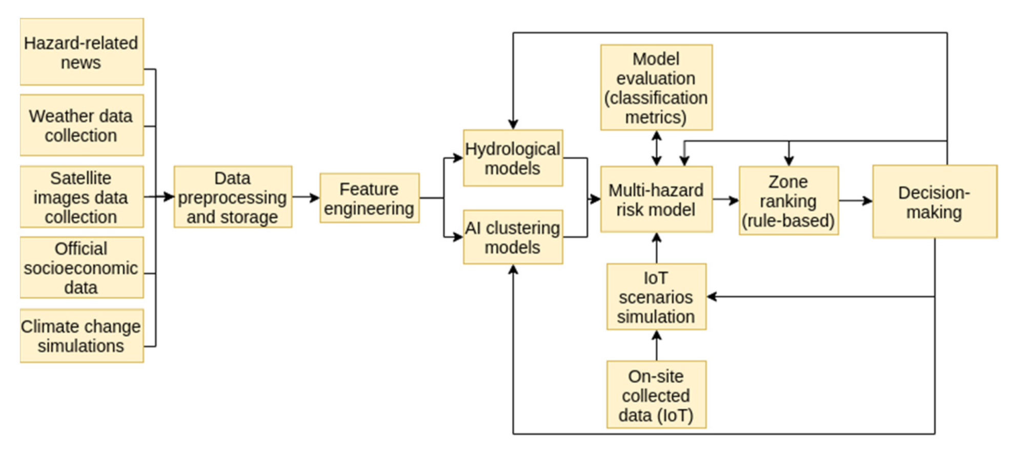
4. Proposed Framework and Data Sources

Figure 1 illustrates the proposed framework. It is comprised of four main components:
  • Event prediction, which aims to predict the probability and potential impact of specific extreme climate events on specific areas. It considers both multiple temporal and spatial scales due to the use of spatial-temporal clustering methods. It encompasses the following tasks: (i) heterogeneous data collection, considering specific hazard-related news, weather data, satellite images, official socioeconomic data, and climate change simulations; (ii) data preprocessing and storage, considering specific tasks related to each data type; (iii) feature engineering, generating features such as drought and flood indexes that may help on extracting relevant information from spatial-temporal historical data; and (iv) implementation of hydrological, meteorological, and clustering models. These data will then allow for the identification of crop and exposed soil areas, socioeconomic aspects, extreme event probability and potential impact, multi-hazard trends, and the prediction of the impacts of climate change scenarios.
  • Use of IoT technologies for real-time environmental monitoring, using both data from computer simulations based on data from weather stations and wireless sensor networks installed on the agricultural areas.
3.
Multi-hazard risk mapping, considering as inputs the results of the models implemented on component one and of the simulations on component two. This component calculates a risk index for each agricultural area using pixel-based data. Additionally, several AI models, such as deep learning models with different hyperparameters, can simulate different scenarios. These are then evaluated using: (i) traditional classification metrics, such as precision, recall, and F1-score; and (ii) key performance indicators related to economics, environmental, and social relevant aspects. Lastly, a rule-based model is used to aggregate the pixels into zones and to rank the different zones according to vulnerability criteria.
4.
Decision-making, in which the final results of the simulations of component three are presented, along with their associated quality metrics, in different formats (dashboards, visualizations, maps, tables, among others that are relevant for the specific stakeholders). This component also considers several essential feedback loops, in which the stakeholders can provide additional input or change the hyperparameters used by the models in all previous components. This stakeholder feedback loop is essential for improving the quality of the information provided for decision-making and incorporating knowledge derived from external sources that the models do not consider.

5. Conclusions and Future Works

The expected increase in extreme climate events will significantly impact agricultural areas and agro-industrial supply chains. In this work, we proposed a data-driven theoretical framework for multi-hazard risk mapping, considering extreme climate events prediction and environmental monitoring using multiple models and heterogeneous data sources. The nine main requirements were presented. The framework proposed fulfilled all requirements identified and considered several aspects that improve the current models in the literature by considering the three pillars of sustainability, both event prediction and ecosystem monitoring tasks, using hazard-specific and general climate heterogeneous data, and considering different climate change scenarios. Its use could provide relevant information for different decision-makers on the supply chains, from farmers to distributors and Government agencies. Future works are related to: framework implementation and its evaluation on several case studies on different areas, crops, and climate change scenarios, and a stakeholder evaluation of its applicability.

Author Contributions

Conceptualization, R.F.S.; methodology, R.F.S. and M.C.F.; investigation, R.F.S. and M.C.F.; writing—original draft preparation, R.F.S.; writing—review and editing, M.C.F., A.M.S., E.M.M., C.E.C. and A.C.B.D.; supervision, A.M.S., E.M.M. and A.C.B.D. All authors have read and agreed to the published version of the manuscript.

Funding

This work was carried out at the Center for Artificial Intelligence (C4AI-USP), with support by: the São Paulo Research Foundation (FAPESP grant #2019/07665-4), IBM Corporation, Itaú Unibanco S.A., through the Centro de Ciência de Dados (C2D-USP), and the National Council for Scientific and Technological Development (CNPq).

Institutional Review Board Statement

Not applicable.

Informed Consent Statement

Not applicable.

Conflicts of Interest

The authors declare no conflict of interest.

References

  1. Liu, X.; Zhu, X.; Pan, Y.; Li, S.; Liu, Y.; Ma, Y. Agricultural drought monitoring: Progress, challenges, and prospects. J. Geogr. Sci. 2016, 26, 750–767. [Google Scholar] [CrossRef]
  2. Rasmussen, L.V.; Bierbaum, R.; Oldekop, J.A.; Agrawal, A. Bridging the practitioner-researcher divide: Indicators to track environmental, economic, and sociocultural sustainability of agricultural commodity production. Glob. Environ. Chang. 2017, 42, 33–46. [Google Scholar] [CrossRef]
  3. Jung, J.; Maeda, M.; Chang, A.; Bhandari, M.; Ashapure, A.; Landivar-Bowles, J. The potential of remote sensing and artificial intelligence as tools to improve the resilience of agriculture production systems. Curr. Opin. Biotechnol. 2021, 70, 15–22. [Google Scholar] [CrossRef] [PubMed]
  4. Cogato, A.; Meggio, F.; Migliorati, M.A.; Marinello, F. Extreme weather events in agriculture: A systematic review. Sustainability 2019, 11, 2547. [Google Scholar] [CrossRef]
  5. Mirza, M.M.Q. Climate change and extreme weather events: Can developing countries adapt? Clim. Policy 2003, 3, 233–248. [Google Scholar] [CrossRef]
  6. Gallina, V.; Torresan, S.; Critto, A.; Sperotto, A.; Glade, T.; Marcomini, A. A review of multi-risk methodologies for natural hazards: Consequences and challenges for a climate change impact assessment. J. Environ. Manag. 2016, 168, 123–132. [Google Scholar] [CrossRef] [PubMed]
  7. Kappes, M.S.; Keiler, M.; Von Elverfeldt, K.; Glade, T. Challenges of analyzing multi-hazard risk: A review. Nat. Hazards 2012, 64, 1925–1958. [Google Scholar] [CrossRef]
  8. Brito, M.M.; Evers, M. Multi-criteria decision-making for flood risk management: A survey of the current state of the art. Nat. Hazards Earth Syst. Sci. 2016, 16, 1019–1033. [Google Scholar]
  9. Stagge, J.H.; Kohn, I.; Tallaksen, L.M.; Stahl, K. Modeling drought impact occurrence based on meteorological drought indices in Europe. J. Hydrol. 2015, 530, 37–50. [Google Scholar] [CrossRef]
  10. Kim, T.W.; Jehanzaib, M. Drought risk analysis, forecasting and assessment under climate change. Water 2020, 12, 1862. [Google Scholar] [CrossRef]
  11. Brémond, P.; Grelot, F.; Agenais, A.L. Flood Damage Assessment on Agricultural Areas: Review and Analysis of Existing Methods. hal-00783552. 2013. Available online: https://hal.archives-ouvertes.fr/hal-00783552 (accessed on 26 July 2021).
Figure 1. Proposed framework for multi-hazard risk mapping of agricultural areas.
Engproc 09 00039 g001
Publisher’s Note: MDPI stays neutral with regard to jurisdictional claims in published maps and institutional affiliations.

