1. Introduction
Albania is a country rich in biodiversity of medicinal and aromatic plants (MAPs). They are a major economic, social and environmental resource for the country, especially for hilly and the mountainous areas. Each year, the MAPs chain employs between 70,000 and 100,000 people [
1,
2], for an average value of USD 25 million [
3]. At the global level, according to the COMTRADE database, the annual growth rate of this market is 9% [
4].
To meet this growing global demand, competition between industries and between the same firms of the same industry is very strong. For them to ensure the raw material, and thus to know the potential of habitats and to check its origin, is information of the utmost importance [
5,
6].
In Albania, currently the key issue is that there is no real time and space information about the origins of the collected quantity, geographic distribution and the potential of their habitats [
2,
7]. Therefore, the final objective of this research is to build a model observatory for MAPs that will serve as a decision support tool for all actors in the sector. Our hypothesis is: through the information we obtain from gatherers and human sensors (Global Positioning System—GPS), we can build an observatory of MAPs, aiming to sustainably manage these resources.
2. Materials and Methods
The methodology used to build and test an experimental model of the operation of an observatory goes through several stages. The first stage was the modelling of a database that would serve as an experimental model for monitoring the MAPs sector. For this, we used the MERISE methodology [
8].
The second stage was the collection of useful information that served as input for model testing, by producing as output two important pieces of information that were used for decision-making by MAPs branch actors: mapping of the used habitat and statistical analysis of collection time. For this, we used two sources of information. The first comes from the plant collector and their activity, while the second source comes from the inventories carried out by the forest service agencies. The data collected from the plant collector are qualitative and quantitative, and have to do with the plant name, its geographical location, the quantity collected by the users of these plants, as well as geographical information related to the tracking of the collector’s activity using a GPS instrument. To collect this information, we used the “5W1H” method.
Meanwhile, to recover the geographical information, in the district of Tepelena, in the village of Dragot, we equipped the plant collector with GPS in order to provide us with all the GPS tracks that accompany active plant collection during the year.
3. Results and Discussion
In our case, this database of MAPs observatory is made up of four large associative tables (ta) and six tables (t) which, by merging them, form the associative tables. The “central” table is the t_observations table. This table contains the quantitative or qualitative values of all the observations. Each row of the table corresponds to a unique observation.
3.1. Conceptual Model Testing
Most of the time, the use of the OMAPs database consists of making specific requests from the v_observations global view. For us, two types of data use are tested:
3.1.1. Use of GPS Data from Picking Areas
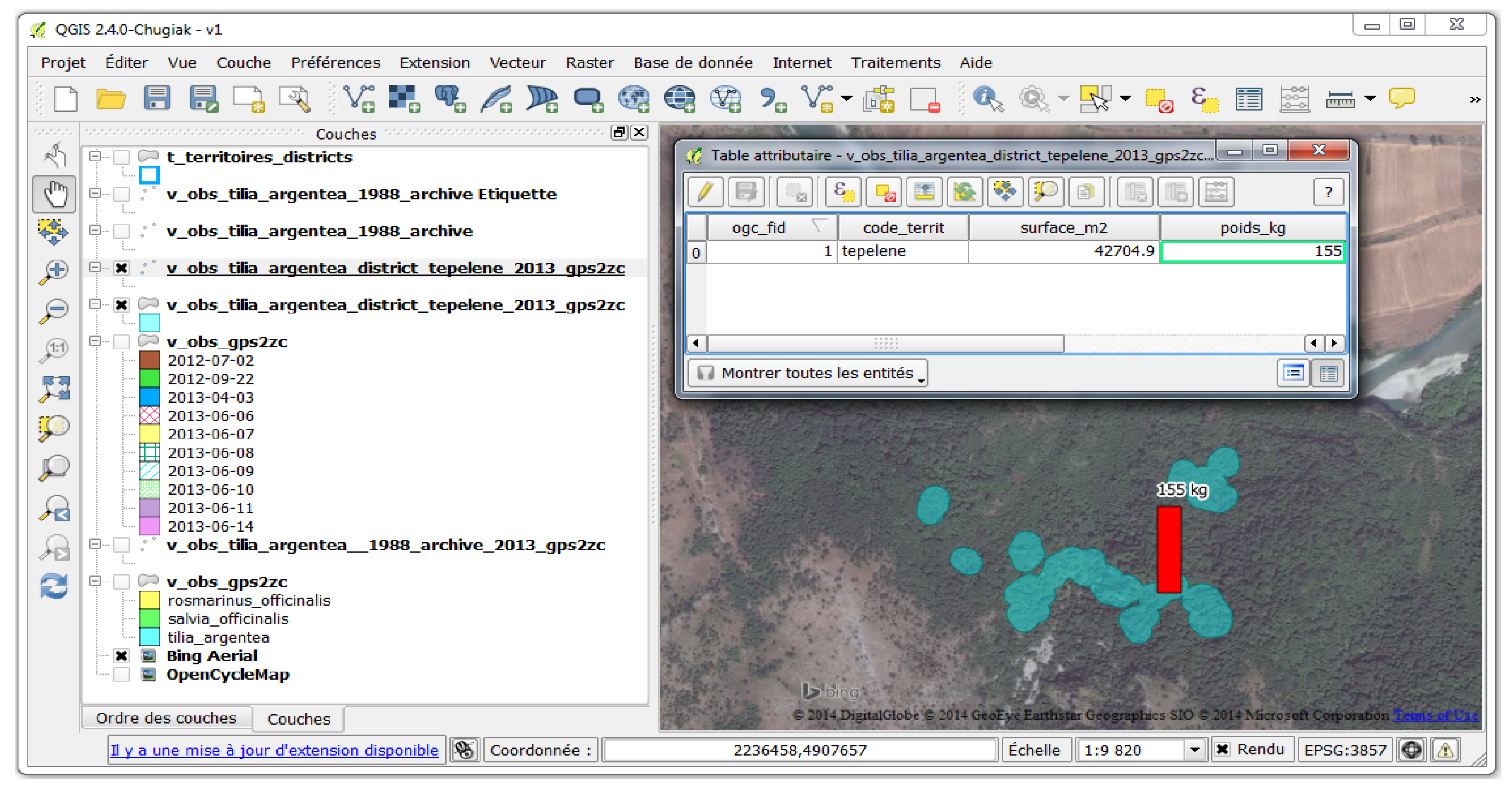
Picking areas are the basic elements that will help to restore the exploited habitat of a plant. To aggregate only the picking areas of the Tepelena district, the above SQL query realises a spatial intersection between the picking areas and the Tepelena district.
The result of this query is displayed in the form of a map and a data table (attribute data) in
Figure 1. This cartographic display can also be represented as a bar histogram to better visualise the quantity of plants extracted from the exploited habitat (red bar in
Figure 1).
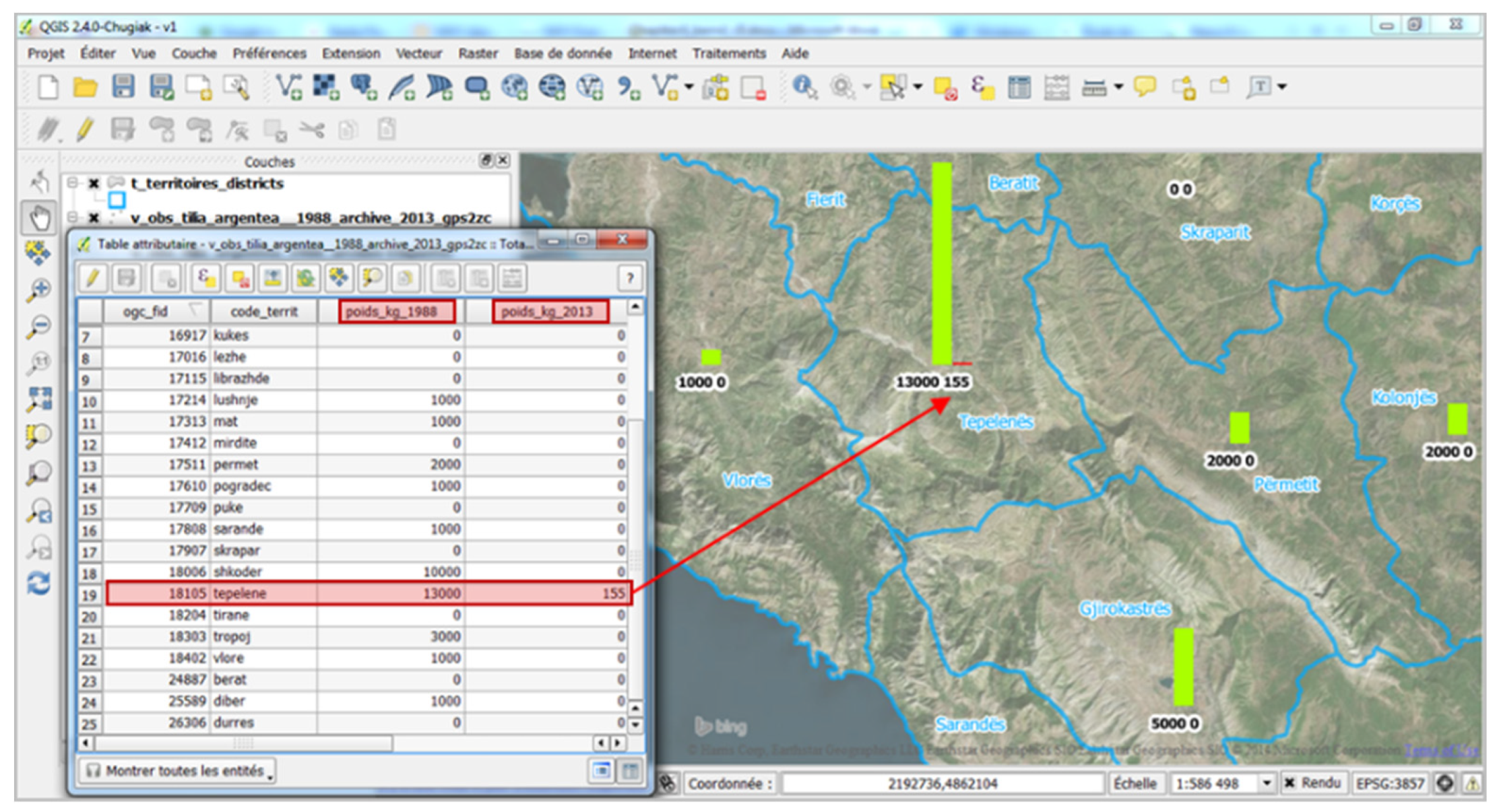
3.1.2. Cross-Referencing of Historical Data with GPS Data
The final test is to show that it is possible to aggregate data from individual picking areas, in order to make them directly comparable to certain data from archives provided at the district level. To “cross” these two types of data, they must be at the same scale, or even be attached to the same geographic reference entity. The constructed SQL query makes it possible to compare, in the same representation, the 1988 data from the archives (available only at the district level) and the 2013 data based on the modelling of the harvesting areas also aggregated at the district level (
Figure 2).
It is important to note that the comparison carried out is not representative because it would be necessary to have all the modelled collection zones of all the collectors at the district level for the year 2013, whereas only some areas are available in the Tepelena district.
4. Conclusions
The experimental model of this observatory shows that it is concretely possible to harmonise heterogeneous data and to visualise the results in a synthetic and systematic way from a single base. In addition, the first tests made it possible to test the structuring of the OMAPs database.
In Albania, as probably in other regions of the world, the exploitation and preservation of natural resources could be objectified via a MAPs observatory, making it possible to manage structured repositories, despite the initial heterogeneity of the data.
Author Contributions
Conceptualisation, V.H. and F.B.; methodology, V.H. and H.I.; software, V.H.; validation, H.I., V.H. and F.B.; investigation, V.H and H.I.; writing—original draft preparation, V.H.; writing—review and editing, H.I. and F.B.; visualisation, V.H.; supervision, F.B. All authors have read and agreed to the published version of the manuscript.
Funding
This research received no external funding.
Data Availability Statement
Data sharing not applicable.
Acknowledgments
The technical and human support provided by CIHEAM-IAM of Montpellier is gratefully acknowledged.
Conflicts of Interest
The authors declare no conflict of interest.
References
- Naka, K.; Musabelliu, B. Social and Economic Relevance of NTFPs in Albania. In Albanian National Forest Inventory (ANFI) Special Study; USAID Project; Agricutlural University of Tirana: Tirana, Albania, 2003; p. 60. [Google Scholar]
- USAID. Albania Medicinal and Aromatic Plants: Value Chain Assesment; Technical report; USAID—Albania Agriculture Competitiveness (AAC) Program: Tirana, Albania, 2010; p. 85. [Google Scholar]
- Lekoçaj, J.; Hoxha, V. Information System for Medicinal and Aromatic Plants Value Chain: Case Study of Albania. Bus. Syst. Rese. 2019, 10, 31–41. [Google Scholar] [CrossRef] [Green Version]
- Ilbert, H.; Hoxha, V. Marché mondial des plantes: Analyse des échanges et de la position de l’Albanie et de l’Algérie. In Le Marché des Plantes Aromatiques et Médicinales: Analyse des Tendances du Marché Mondial et des Stratégies Economiques en Albanie et en Algérie; Ilbert, H., Hoxha, V., Sahi, L., Courivaud, A., Chailan, C., Eds.; Options Méditerranéennes: Série B; Etudes et Recherches, CIHEAM-IAMM: Montpellier, France, 2016; pp. 17–44. [Google Scholar]
- Schippmann, U.; Leaman, D.; Cunningham, A.B. A comparison of cultivation and wild collection of medicinal and aromatic plants under sustainability aspects. In Medicinal and Aromatic Plants; Bogers, R.J., Craker, L.E., Lange, D., Eds.; Springer: Dodlerk, The Netherlands, 2006; pp. 75–95. [Google Scholar]
- Leaman, D.J. Soulager la pression. Planète Conserv. 2009, 39, 8–10. [Google Scholar]
- Hoxha, V. Quelles méthodes pour la gestion durable de la ressource des plantes aromatiques et médicinales? Analyse des inventaires historiques en Albanie et modélisation des habitats à partir des traces GPS des cueilleurs en vue de la construction d’un observatoire. Thèse de doctorat, Université Paul Valéry, UM3, Montpellier, France, 2014; p. 263. [Google Scholar]
- Morley, C. Management d’un Projet Système d’Information. Principes, Techniques, Mise en Œuvre et Outils, 6ème éd.; Paris: Dunod, France, 2008; 458p. [Google Scholar]
| Publisher’s Note: MDPI stays neutral with regard to jurisdictional claims in published maps and institutional affiliations. |
© 2021 by the authors. Licensee MDPI, Basel, Switzerland. This article is an open access article distributed under the terms and conditions of the Creative Commons Attribution (CC BY) license (https://creativecommons.org/licenses/by/4.0/).


