Abstract
Several studies have already evaluated the ability to identify wildfires and their characteristics by using NOAA-AVHRR and EO-MODIS images, which have adequate spectral bands for these targets, although with a spatial resolution limited to 1 km and a daily revisit time. In many cases, the latter features can limit the timely identification of a fire and the monitoring of its evolution. Conversely, sensors operating on geostationary platforms could acquire images within less than half an hour, yet still with a nominal spatial resolution of 1 km. In this study, we perform an analysis at different spatial resolutions of a sequence of OLI-Landsat-8 images referring to a natural fire that occurred near Massarosa, Tuscany, in July 2022. In particular, we investigate the potential of the SWIR bands, which are useful for monitoring high temperature wildfires. The results suggest that the use of sensors onboard a geostationary platform with relatively high nominal spatial resolution (of the order of 1 km) and frequent revisit time could enable the timely detection of fires and their monitoring.
1. Introduction
Fires can deeply modify the cover and characteristics of the soil—depending on their intensity, extension, and duration—and release substances and energy into the atmosphere. Thus, they are recognized as a key factor for environmental studies and the global energy balance of the Earth. The prevention, monitoring, and control of forest fires is an important aspect for the management of the territory and the environment, both at local, national, and global scales. Innovative satellite technologies represent a useful tool for the timely recognition, characterization, and monitoring of fire evolution, as well as for the subsequent assessment of environmental damage. In most European countries and specifically in Italy, the problem of monitoring and assessing the damage due to fires mainly relates to both medium and low fires with high thermal intensity that develop in a few hours. Their detection should occur within a short time after ignition; so, a high temporal frequency of observation is of primary importance in order to detect the fire and monitor its effects with the aim to define the most appropriate intervention policies. In this context, sensors operating from geostationary platforms could offer several advantages with adequate revisit time at local, regional, and synoptic scales.
The first studies on satellite remote sensing of forest fires date back to about 40 years ago with exploitation of NOAA-AVHRR data [1,2,3] and subsequently of MODIS data on board the Aqua and Terra platforms [4,5]. Sensors operating on a geostationary platform (GOES, Meteosat MTG, etc.) have also been taken into consideration: these are capable of acquiring an image of the globe every 10–20 min and therefore would be very useful for monitoring phenomena with high temporal variability such as fires [6]. Their poor spatial resolution, however, has represented the main limit of their use.
Satellite monitoring of active fires is mainly based on acquisitions in the Mid-InfraRed (MIR) bands between 3.0 μm and 4.0 μm and Thermal InfraRed (TIR) in the 8 μm–12.5 μm spectral range. Visible and NIR (near infrared) bands are used for the elimination of false positives (clouds, sun glint, etc.). Short Wavelength InfraRed (SWIR) bands of atmospheric transparency at 1.55 μm–1.75 μm and 2.1 μm–2.3 μm can be also considered since they are sensitive to intense flaming fires with temperatures above 1000 K [7]. The detection of fires also requires a spatial resolution sufficient to highlight the presence of anomalous radiant energy levels caused by the fire. For fires of medium–small extensions, as the spatial resolution becomes worse, the signal becomes less intense because it is averaged over a larger area, until the anomaly cannot be detected.
This work investigates the potential of SWIR bands to detect high temperature wildfires at different spatial resolutions by analyzing a sequence of Landsat-8 and Landsat-9 OLI (Operative Landsat Imager) images acquired over an area affected by a natural wildfire event that occurred in July 2022 near Massarosa, Tuscany.
2. Study Area
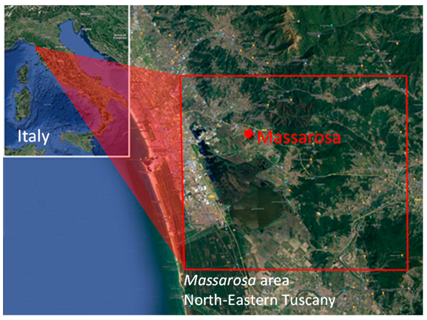
The area we studied is located near to the town of Massarosa in Northeastern Tuscany, Italy. This area was affected by a fire of considerable intensity from 19 July 2022 to 22 July 2022. In its entirety, the fire damaged an area of approximately 8.41 km2. The area includes hills with altitude variation between 200 and 400 m that is covered by woods and agricultural crops. The summer climate is mild, of the Mediterranean type (Figure 1).

Figure 1.
Image of the study area located close to Massarosa (43°52′ N 10°20′ E), Italy.
3. Results
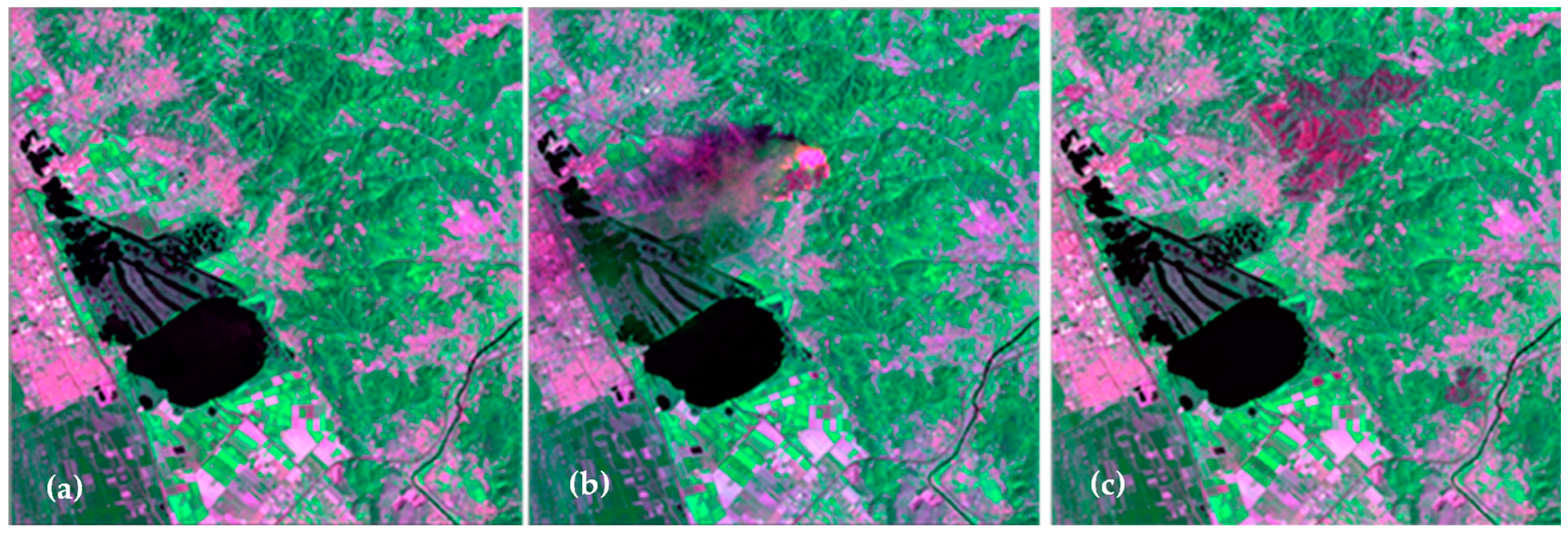
For this study, we used a series of Landsat 8 and 9 images (refer to [8] for the complete list of spectral bands) in order to monitor the fire in the study area. The dataset was composed of ten images with 30 m spatial resolution: four of these images were acquired immediately the day before the start of the fire (18 July 2022), whereas the other five images were acquired from 19 July 2022—when the fire was active over an area of about 0.683 km2 with very intense temperatures over a flaming area of about 0.395 km2—to 20 August 2022. We also included in the dataset the images acquired from 27 July 2022 to 20 August 2022 in order to evaluate the total damage extent caused by the fire by comparing it with the image prior to the fire breakout (Figure 2).
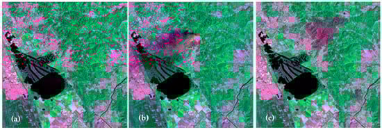
Figure 2.
Landsat images: (a) image acquired before the fire (18 July 2022); (b) image acquired during the development of the fire (19 July 2022); (c) image acquired a few days after the end of the event (27 July 2022). RGB composition = (SWIR2200, NIR, SWIR1610).
In order to evaluate the utility of SWIR bands for monitoring forest fires as a function of spatial resolution, a set of simulated images—based on the original Landsat images with spatial resolution of 30 × 30 m—was generated by means spatial resampling of iterative half-band digital filtering. In this way, we produced a sequence of images of the test area with spatial resolutions at 30 m, 60 m, 120 m, 240 m, 480 m, 960 m, and 1920 m. The algorithm used to identify the areas affected by the fire was based on the relationship (1) [9]:
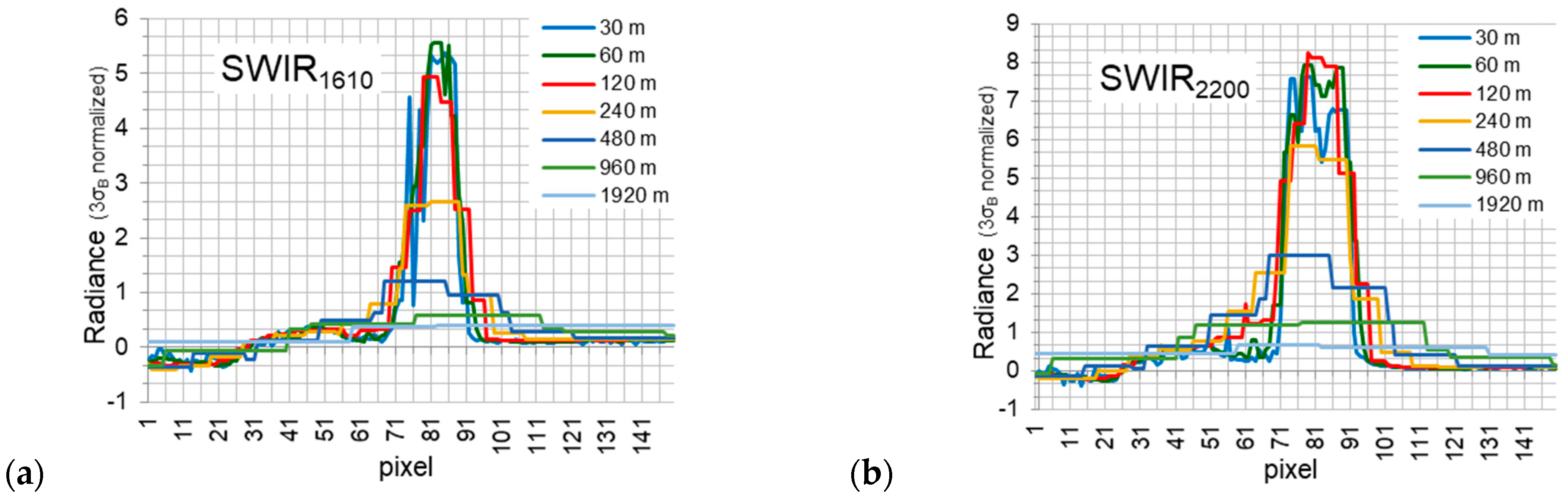
where ρF(λ) is the reflectance at the time tF after the fire breakout, ρB(λ) is the background reflectance measured at time tB before the fire breakout, and σB is the standard deviation of the background. The background reflectance is typically estimated either as the average value of a set of points not affected by the fire selected around the fire area [1,9] or derived from previous acquisitions [10]. In our study, the background reflectance was derived from the image acquired on the day before the fire breakout. In our case, pixels with signal saturation due to the fire are evident in the area of greatest fire intensity in the SWIR bands of interest—SWIR1610 (SWIR band at 1610 nm) and SWIR2200 (SWIR band at 2200 nm) of the Landsat 8 data [8]—which prevented the possibility of estimating the temperature and the percentage of burned area [1,2,9]. We used the simulated image series to investigate the impact of spatial resolution for the fire detection by means of the SWIR bands. Figure 3a,b report the signal intensity—for different spatial resolutions—in the SWIR1610 and SWIR2200, respectively, along a transect crossing the fire. The graphs highlight the anomaly detected in correspondence with the fire with respect to the surrounding pixels (background). The radiance is normalized to 3σB; so, the pixels with normalized radiance values greater than 1 can be classified as affected by the fire. From Figure 3, we can also infer that both the SWIR1610 and SWIR2200 bands have good potential for detecting fire-affected pixels.
ρF (λ) − ρB (λ) > 3σB,
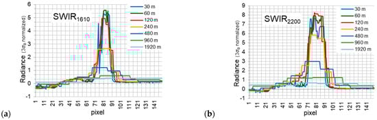
Figure 3.
SWIR band radiance along a transect crossing the fire for different spatial resolutions: (a) SWIR band at 1610 nm and (b) SWIR band at 2200 nm. Radiance was normalized at 3σB.
The SWIR1610 is 4–6 times higher than the threshold value for spatial resolutions of 30 m, 60 m, and 120 m. Spatial resolution from 240 m to 480 m are suitable for identifying burning pixels with values between 1 and 2 times the threshold, while resolutions of 960 m and 1980 m are below the detection threshold. The SWIR2200 image sequence showed a similar behavior, with the advantage that even the 960 m resolution could be used to detect the pixels affected by the fire, although with a value just above the threshold.
4. Conclusions
Fire detection and monitoring by satellite imagery could take strong advantage of the frequent revisit time provided by geostationary satellites. This study suggests that, besides the MIR and TIR bands, the SWIR atmospheric transparency bands could be successfully exploited for fire monitoring if acquired with a spatial sampling better than 1000 m.
Author Contributions
Conceptualization, R.C., S.B. and V.R.; methodology, R.C. and S.B.; software, R.C.; validation, R.C., S.B. and V.R.; formal analysis, R.C., S.B. and V.R.; investigation, A.G. and R.C.; resources, R.C. and V.R.; data curation, A.G. and R.C.; writing—original draft preparation, A.G. and R.C.; writing—review and editing, A.G., R.C., S.B. and V.R.; visualization, A.G. and R.C.; supervision, V.R.; project administration, V.R.; funding acquisition, V.R. All authors have read and agreed to the published version of the manuscript.
Funding
This research was funded by the European Union’s Horizon 2020 research and innovation program under Grant Agreement No 870390.
Institutional Review Board Statement
Not applicable.
Informed Consent Statement
Not applicable.
Data Availability Statement
Data analyzed in this study are publicly available at: https://earthexplorer.usgs.gov (accessed on 22 September 2023).
Conflicts of Interest
The authors declare no conflict of interest.
References
- Dozier, J. A Method for Satellite Identification of Surface Temperature Fields of Subpixel Resolution. Remote Sens. Environ. 1981, 11, 221–229. [Google Scholar] [CrossRef]
- Matson, M.; Dozier, J. Identification of Subresolution High Temperature Sources Using a Thermal IR Sensor. Photogramm. Eng. Remote Sens. 1981, 47, 1311–1318. [Google Scholar]
- Li, Z.; Kaufman, Y.J.; Ichoku, C.; Fraser, R.; Trishchenko, A.; Giglio, L.; Jin, J.; Yu, X. A Review of AVHRR-based Active Fire Deection Algorithms: Principles, Limitations and Reccomandations. In Global and Regional Vegetation Fire Monitoring from Space: Planning a Coordinated International Effort; Ahern, F.J., Goldammer, J.G., Justice, C.O., Eds.; SPB Academic Publishing: The Hague, The Netherlands, 2001; pp. 199–225. [Google Scholar]
- Kaufman, Y.J.; Justice, C.O.; Flynn, L.P.; Kendall, J.D.; Prins, E.M.; Giglio, L.; Ward, D.E.; Menzel, P.W.; Setzer, A.W. Potential Global Fire Monitoring from EOS-MODIS. J. Geophys. Res. 1998, 103, 32215–32238. [Google Scholar] [CrossRef]
- Giglio, L.; Descloitres, J.; Justice, O.; Kaufman, Y.J. An Enhanced Contextual Fire Detection Algorithm for MODIS. Remote Sens. Environ. 2003, 87, 273–282. [Google Scholar] [CrossRef]
- Bandinelli, G.; Carlà, R. Fire Detection by Analysis of Infrared Satellite Imagery 1992. In Proceedings of the Advanced Infrared Technology and Applications Conference, Florence, Italy, 13–14 April 1992; pp. 415–428. [Google Scholar]
- Tang, H.; Li, Z.L. Quantitative Remote Sensing in Thermal Infrared: Theory and Applications; Springer Remote Sensing/Photogrammetry; Springer: Berlin/Heidelberg, Germany, 2014. [Google Scholar] [CrossRef]
- LANDSAT 8 BANDS. Available online: https://landsat.gsfc.nasa.gov/satellites/landsat-8/landsat-8-bands/ (accessed on 22 September 2023).
- Goessmann, F.; Maier, S.W.; Lynch, J. Improved Spatial Resolution of Fire Detection with MODIS Using the 2.1 µm Channel. In Innovations in Remote Sensing and Photogrammetry; Springer: Berlin/Heidelberg, Germany, 2009; pp. 183–189. [Google Scholar]
- Maier, S.W. Using the predictive power of a kernel driven BRDF model to map clouds and burnt areas. In Proceedings of the 4th International Workshop on Multiangular Measurements and Models, Sydney, Australia, 20–24 March 2006. [Google Scholar]
Disclaimer/Publisher’s Note: The statements, opinions and data contained in all publications are solely those of the individual author(s) and contributor(s) and not of MDPI and/or the editor(s). MDPI and/or the editor(s) disclaim responsibility for any injury to people or property resulting from any ideas, methods, instructions or products referred to in the content. |
© 2023 by the authors. Licensee MDPI, Basel, Switzerland. This article is an open access article distributed under the terms and conditions of the Creative Commons Attribution (CC BY) license (https://creativecommons.org/licenses/by/4.0/).