

Constraints and Opportunities of Agricultural Development in Haor Ecosystem of Bangladesh


 ,
, 
Abstract
1. Introduction
2. Materials and Methods
3. Results and Discussion
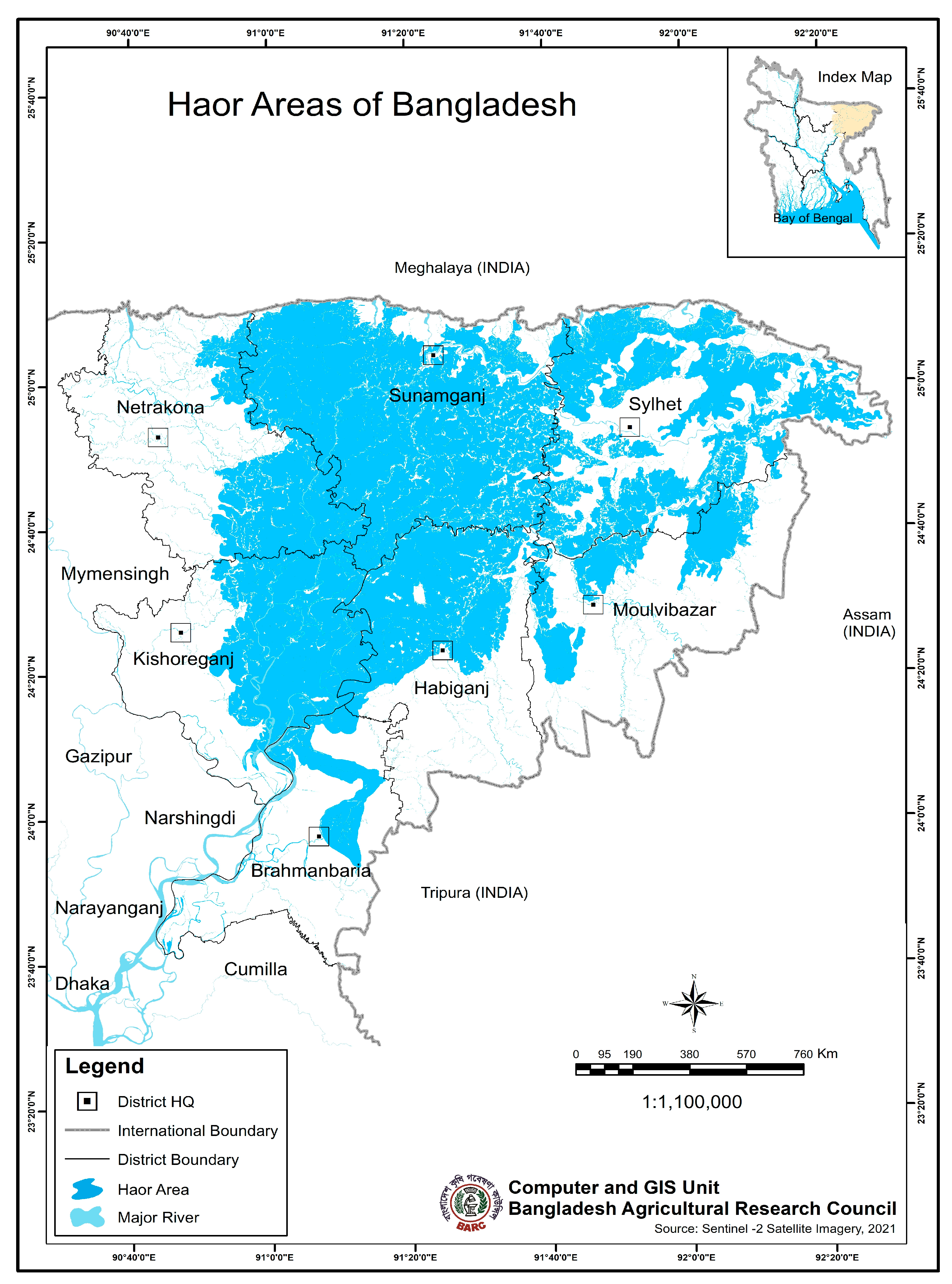
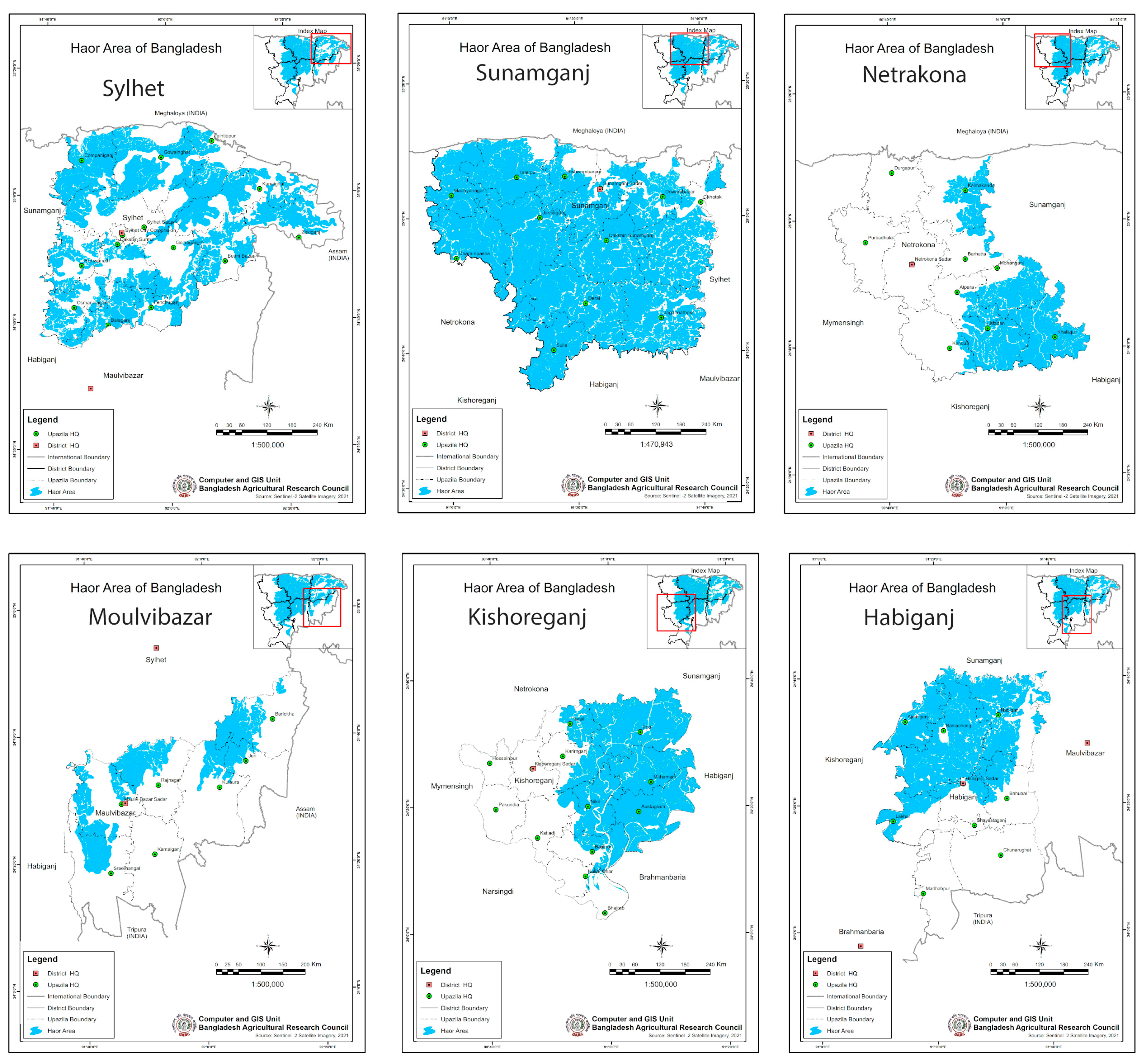
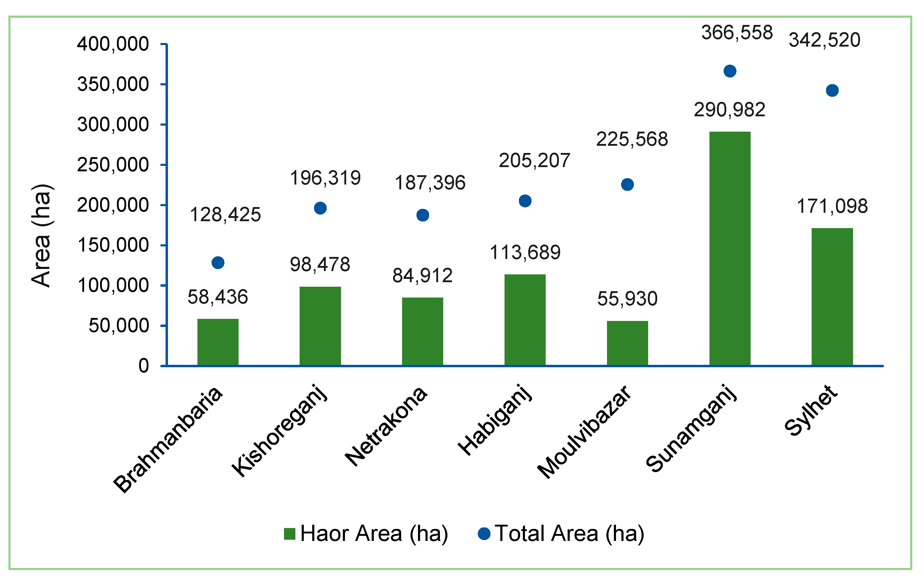
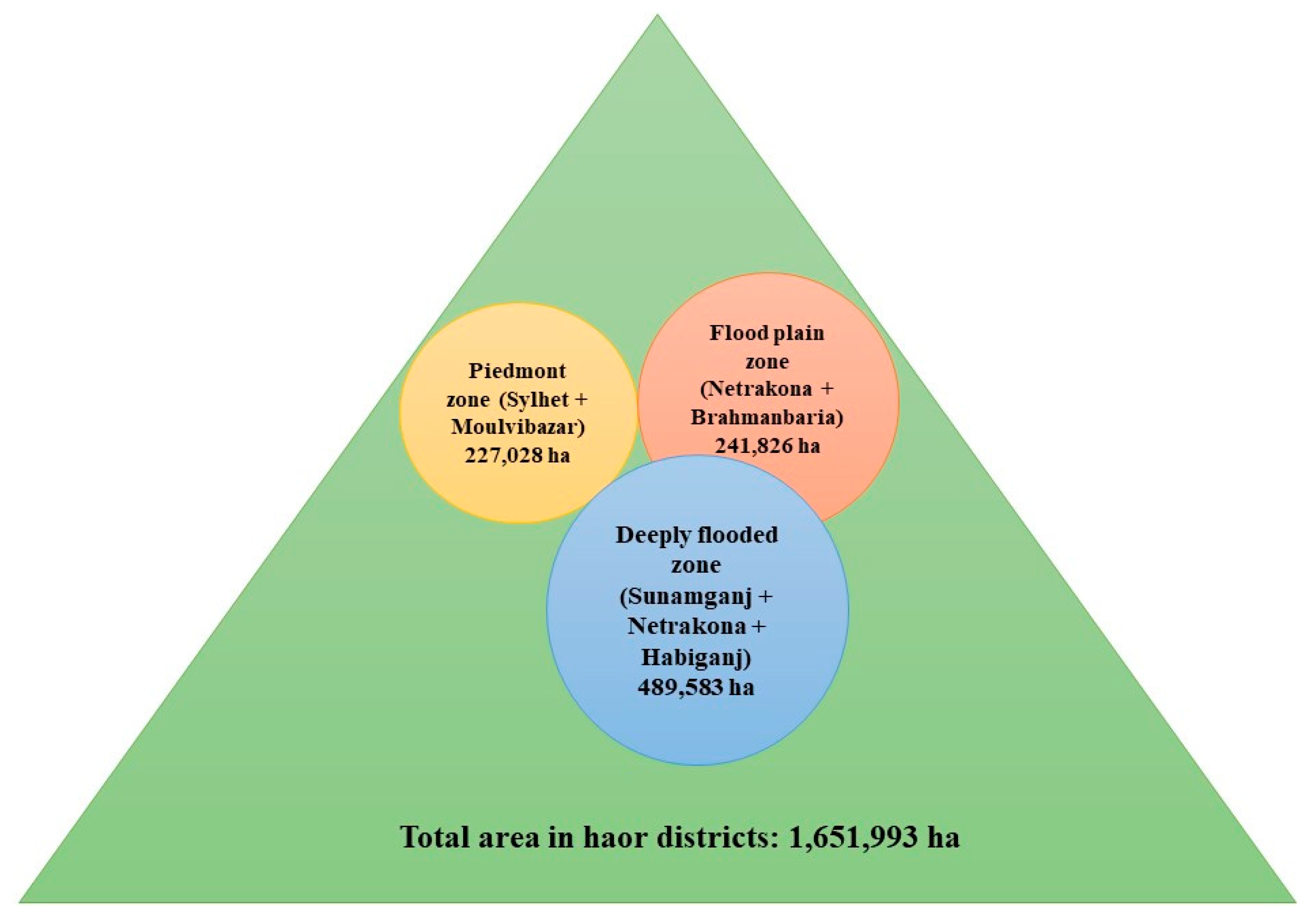
3.1. Extent and Distribution
3.2. Biophysical Characteristics
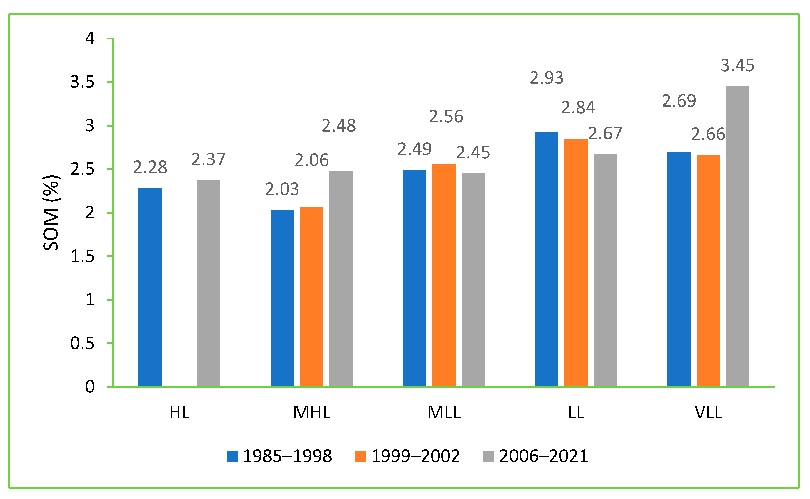
3.2.1. Land and Soil
3.2.2. Climate
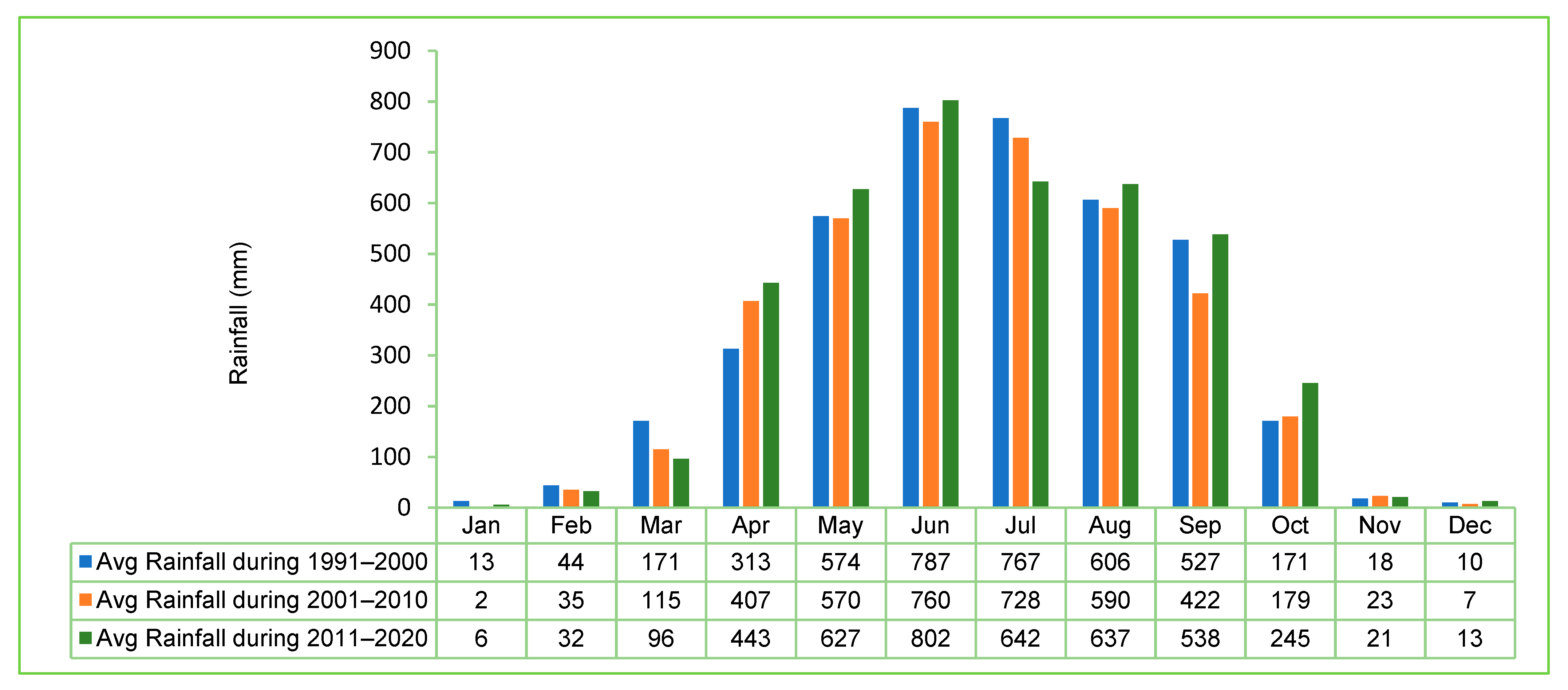
3.2.3. Rainfall
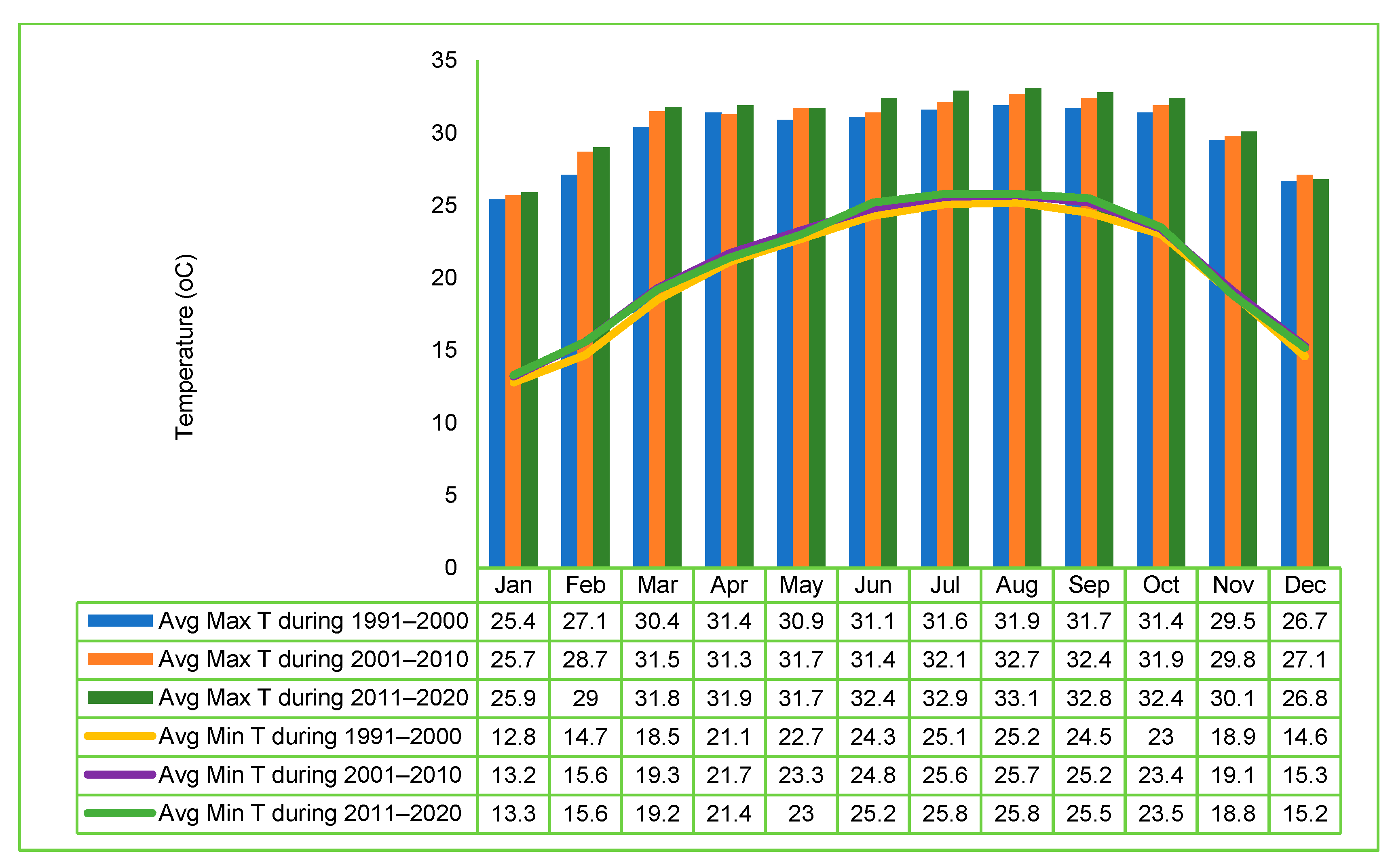
3.2.4. Temperature
3.2.5. Water Regime
3.2.6. Flash Floods
3.3. Demographic and Socioeconomic Features
3.4. Agricultural Production Systems
3.4.1. Land Use Patterns
3.4.2. Crops and Cropping Patterns
3.4.3. Livestock and Poultry
3.4.4. Fisheries and Aquaculture
3.4.5. Forestry
3.5. Cross-Cutting Issues
3.5.1. Agricultural Mechanization
3.5.2. Agricultural Marketing
3.6. Advances in Haor Agriculture
3.6.1. Crops
3.6.2. Livestock and Poultry
3.6.3. Fisheries
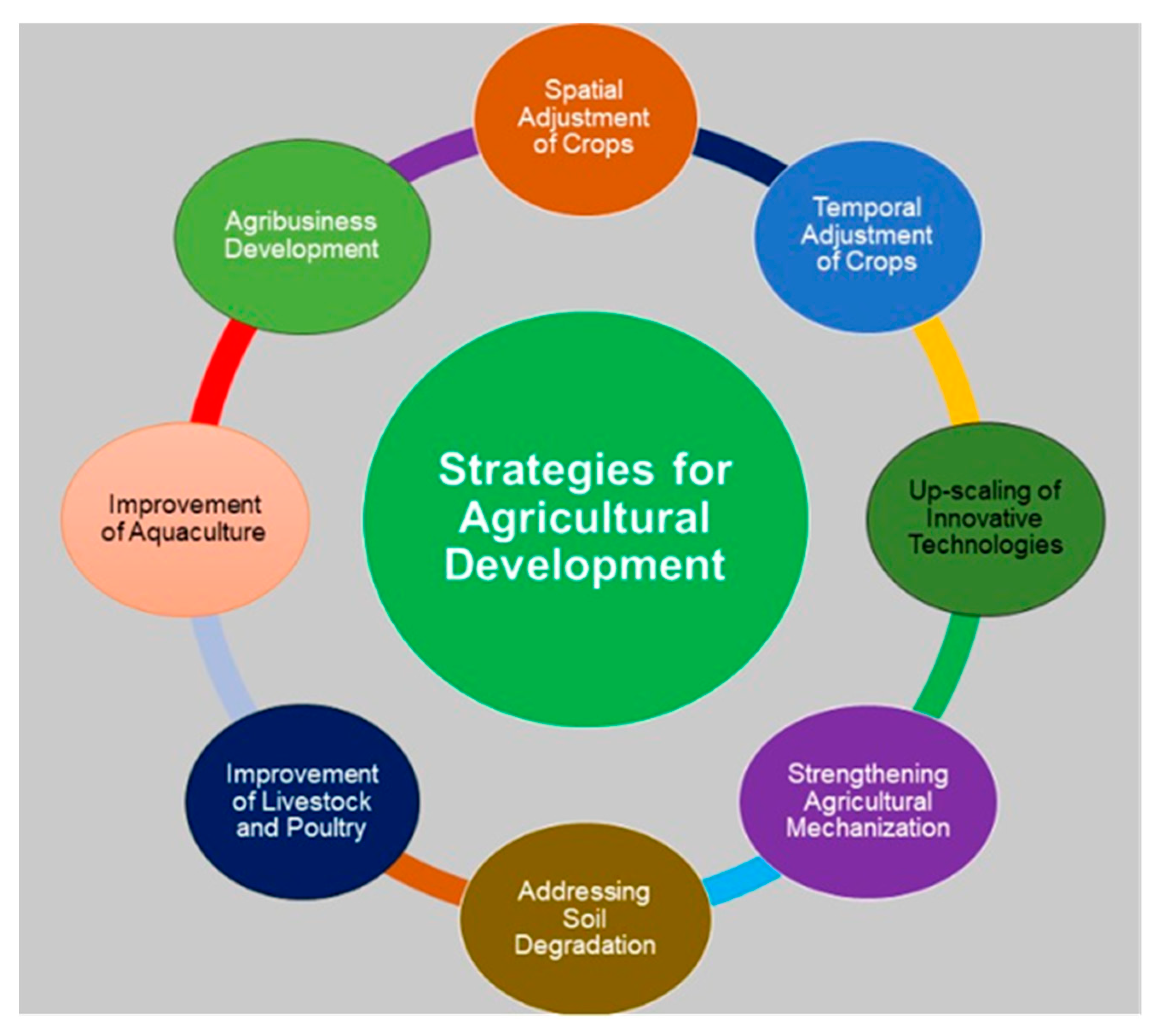
3.7. Strategies for Agricultural Development
3.7.1. Spatial Adjustment of Crops
3.7.2. Temporal Adjustment of Crops
3.7.3. Up-Scaling of Innovative Technologies
3.7.4. Strengthening Agricultural Mechanization
3.7.5. Addressing Soil Degradation
3.7.6. Improvement of Livestock and Poultry
3.7.7. Improvement of Aquaculture
3.7.8. Agribusiness Development
3.8. Potential Challenges in Implementing Strategies
3.8.1. Policy Challenges
3.8.2. Financial Constraints
3.8.3. Technological Barriers
3.8.4. Community Engagement Strategies
4. Conclusions
Supplementary Materials
Author Contributions
Funding
Institutional Review Board Statement
Informed Consent Statement
Data Availability Statement
Acknowledgments
Conflicts of Interest
References
- Bangladesh-Delta-Plan-2100—Planning Commission-Government of the People’s Republic of Bangladesh. Available online: http://www.plancomm.gov.bd/site/files/0adcee77-2db8-41bf-b36b-657b5ee1efb9/Bangladesh-Delta-Plan-2100 (accessed on 22 June 2023).
- Uddin, M.T.; Hossain, N.; Dhar, A.R. Business Prospects and Challenges in Haor Areas of Bangladesh: Business Prospects and Challenges in Haor Areas. J. Bangladesh Agric. Univ. 2019, 17, 65–72. [Google Scholar] [CrossRef]
- Sarma, P.K. Scenario of Haor Vulnerabilities and Other Obstacles for Sustainable Livelihood Development in Nikli Upazila. J. Bangladesh Agric. Univ. 2010, 8, 283–290. [Google Scholar] [CrossRef]
- Hoq, M.S.; Uddin, M.T.; Raha, S.K.; Hossain, M.I. Welfare Impact of Market Participation: The Case of Rice Farmers from Wetland Ecosystem in Bangladesh. Environ. Chall. 2021, 5, 100292. [Google Scholar] [CrossRef]
- Kamruzzaman, M.; Shaw, R. Flood and Sustainable Agriculture in the Haor Basin of Bangladesh: A Review Paper. Univ. J. Agric. Res. 2018, 6, 40–49. [Google Scholar] [CrossRef]
- Nishat, B.; Chakrabarty, S.K.; Hasan, M.E.; Rahman, A.J.M.Z. Rivers Beyond Borders: India Bangladesh Trans-Boundary River Atlas; Drik Publications: Dhaka, Bangladesh, 2014. [Google Scholar]
- Thakur, J. India-Bangladesh Trans-Boundary River Management: Understanding the Tipaimukh Dam Controversy; ORF Issue Brief No. 334; Observer Research Foundation: New Delhi, India, 2020; p. 18. [Google Scholar]
- Akonda, A.W.; Scott, D.A. A Directory of Asian Wetlands; IUCN: Gland, Switzerland, 1989; pp. 541–581. [Google Scholar]
- Bokhtiar, S.; Samsuzzaman, S.; Jahiruddin, M.; Panaullah, G. Agricultural Development for Fragile Ecosystems in Bangladesh, 1st ed.; Bangladesh Agricultural Research Council: Dhaka, Bangladesh, 2023; ISBN 978-984-35-3818-5.
- Haor Master Plan Volume II. Available online: https://dbhwd.gov.bd/site/publications/e345b982-26a4-4b4a-9f11-1ba389f22509/হাওর-মাস্টার-প্লান-ভলিউম-২ (accessed on 18 April 2024).
- Haors and Wetlands—Banglapedia. Available online: https://en.banglapedia.org/index.php/Haors_and_Wetlands (accessed on 14 May 2023).
- Harris, W.G. Phosphate Minerals. Soil Mineral. Environ. Appl. 2002, 7, 637–665. [Google Scholar]
- Quilliam, R.S.; van Niekerk, M.A.; Chadwick, D.R.; Cross, P.; Hanley, N.; Jones, D.L.; Vinten, A.J.A.; Willby, N.; Oliver, D.M. Can Macrophyte Harvesting from Eutrophic Water Close the Loop on Nutrient Loss from Agricultural Land? J. Environ. Manag. 2015, 152, 210–217. [Google Scholar] [CrossRef] [PubMed]
- Bagchi, R.; Miah, M.A.; Hazra, P.; Hasan, R.; Mondal, H.S.; Paul, S.K. Exploring the Effect of Rainfall Variability and Water Extent in Tanguar Haor, Sunamganj. Aust. J. Eng. Innov. Technol. 2020, 2, 66–76. [Google Scholar]
- Starkel, L.; Singh, S. Rainfall, Runoff and Soil Erosion in the Globally Extreme Humid Area, Cherrapunji Region, India; Institute of Geography and Spatial: Warszawa, Poland, 2004; Volume 191, ISBN 8387954322. [Google Scholar]
- Parry, M.L.; Canziani, O.; Palutikof, J.; Van der Linden, P.; Hanson, C. Climate Change 2007-Impacts, Adaptation and Vulnerability: Working Group II Contribution to the Fourth Assessment Report of the IPCC; Cambridge University Press: Cambridge, UK, 2007; Volume 4, ISBN 0521880106. [Google Scholar]
- Hirabayashi, Y.; Mahendran, R.; Koirala, S.; Konoshima, L.; Yamazaki, D.; Watanabe, S.; Kim, H.; Kanae, S. Global Flood Risk under Climate Change. Nat. Clim. Chang. 2013, 3, 816–821. [Google Scholar] [CrossRef]
- Gardner, R.C.; Finlayson, C. Global Wetland Outlook: State of the World’s Wetlands and Their Services to People. In Proceedings of the Ramsar Convention Secretariat, Gland, Switzerland, 5 October 2018; pp. 2020–2025. [Google Scholar]
- Master Plan of Haor Areas: Volume 1, Summary Report; Ministry of Water Resources, Government of the People’s Republic of Bangladesh: Dhaka, Bangladesh, 2012.
- Rahman, M.R. Technological Fixes for Disaster Management in Bangladesh; People at Risk: Disaster and Despair, Disaster Research Training and Management Centre (DRTMC); University of Dhaka: Dhaka, Bangladesh, 2019; pp. 71–95. [Google Scholar]
- Abedin, J.; Khatun, H. Impacts of Flash Flood on Livelihood and Adaptation Strategies of the Haor Inhabitants: A Study in Tanguar Haor of Sunamganj, Bangladesh. Dhaka Univ. J. Earth Environ. Sci. 2019, 8, 41–51. [Google Scholar] [CrossRef]
- Ministry of Disaster Management and Relief-Government of the People’s Republic of Bangladesh. Available online: http://203.76.123.197/egls/documents/357/search-detail (accessed on 22 April 2024).
- Population-and-Housing-Census-Bangladesh Bureau of Statistics-Government of the People’s Republic of Bangladesh. 2022. Available online: http://www.bbs.gov.bd/site/page/47856ad0-7e1c-4aab-bd78-892733bc06eb/Population-and-Housing-Census. (accessed on 12 April 2023).
- Gillingham, S. CARE Bangladesh Programme Strategy: Haor Region 2015–2020. 2016. Available online: https://www.carebangladesh.org/publication/Publication_5340141.pdf. (accessed on 13 April 2023).
- Yearbook of Agricultural Statistics; Bangladesh Bureau of Statistics (BBS), Statistics Division, Ministry of Planning, Government of the People Republic of Bangladesh: Dhaka, Bangladesh, 2020; ISBN 9789844750470. Available online: https://bbs.gov.bd/site/page/3e838eb6-30a2-4709-be85-40484b0c16c6/Yearbook-of-Agricultural-Statistics (accessed on 13 April 2023).
- Jabbar, M.A.; Alam, M.S. Adoption of Modern Rice Varieties in Bangladesh. Bangladesh J. Agric. Econ. 1993, 16, 1–19. [Google Scholar]
- Muttaleb, M.A.; Shahidullah, S.M.; Nasim, M.; Saha, A. Cropping Systems and Land Use in Sylhet Region. Bangladesh Rice J. 2017, 21, 273–288. [Google Scholar] [CrossRef]
- Rashid, M.H.A.; Islam, A.; Shirazy, B.J.; Shahidullah, S.M. Cropping Systems and Land Use Pattern in Rajshahi Region. Bangladesh Rice J. 2017, 21, 237–254. [Google Scholar] [CrossRef]
- Cell, C.C. Adaptive Crop Agriculture Including Innovative Farming Practices in Haor Basin. 2009. Available online: http://203.76.123.197/egls/documents/19/search-detail (accessed on 27 April 2023).
- Alam, M.S.; Quayum, M.A.; Islam, M.A. Crop Production in the Haor Areas of Bangladesh: Insights from Farm Level Survey. Agriculturists 2010, 8, 88–97. [Google Scholar] [CrossRef]
- Aziz, M.S.B.; Hasan, N.A.; Mondol, M.M.R.; Alam, M.M.; Haque, M.M. Decline in Fish Species Diversity Due to Climatic and Anthropogenic Factors in Hakaluki Haor, an Ecologically Critical Wetland in Northeast Bangladesh. Heliyon 2021, 7, e05861. [Google Scholar] [CrossRef]
- Yearbook of Agricultural Statistics; Bangladesh Bureau of Statistics, Ministry of Planning, Government of the People’s Republic of Bangladesh: Dhaka, Bangladesh, 2012.
- Alam, M.S.; Masum, K.M.; Campus, B.; Sholashahor, B. Status of Homestead Biodiversity in the Offshore Island of Bangladesh. Res. J. Agric. Biol. Sci. 2005, 1, 246–253. [Google Scholar]
- Liong, S.; Lim, W.; Kojiri, T.; Hori, T. Advance Flood Forecasting for Flood Stricken Bangladesh with a Fuzzy Reasoning Method. Hydrol. Process. 2000, 14, 431–448. [Google Scholar] [CrossRef]
- Miah, M.R. Enhancing Food Security through Acclimatized Species Domestication in the Haor Region. ABC J. Adv. Res. 2013, 2, 49–65. [Google Scholar] [CrossRef]
- Bennett, D.S.; Scott, D.D.; Karim, A.; Sobhan, I.; Khan, A.; Rashid, S.M.A. Interpretive Description of the Region’s Wetlands; Wetland Resources Specialist Study, Northeast Regional Water Management Plan, Bangladesh Flood Action Plan 6. 1995. Available online: http://www.bicn.com/wei/resources/nerp/wrs/index.htm (accessed on 5 August 2023).
- Alam, M.S.; Hossain, M.S. Banglapedia: National Encyclopedia of Bangladesh, 2nd ed.; Asiatic Society of Bangladesh: Dhaka, Bangladesh, 2012. [Google Scholar]
- Yearbook of Agricultural Statistics; Bangladesh Bureau of Statistics, Ministry of Planning, Government of the People’s Republic of Bangladesh: Dhaka, Bangladesh, 2015.
- Islam, A.S. Rice Mechanization in Bangladesh, 1st ed.; Kashem, M., Ed.; Bangladesh Rice Research Institute: Gazipur, Bangladesh, 2018.
- Islam, M.J.; Kim, J.W.; Begum, M.K.; Sohel, M.A.T.; Lim, Y.-S. Physiological and Biochemical Changes in Sugar Beet Seedlings to Confer Stress Adaptability under Drought Condition. Plants 2020, 9, 1511. [Google Scholar] [CrossRef]
- Islam, M.J.; Ryu, B.R.; Rahman, M.H.; Rana, M.S.; Cheong, E.J.; Wang, M.-H.; Lim, J.-D.; Hossain, M.A.; Lim, Y.-S. Cannabinoid Accumulation in Hemp Depends on ROS Generation and Interlinked with Morpho-Physiological Acclimation and Plasticity under Indoor LED Environment. Front. Plant Sci. 2022, 13, 984410. [Google Scholar] [CrossRef]
- Islam, M.J.; Mou, M.A.; Razzak, M.A.; Lim, Y.-S. Exogenous Putrescine-Mediated Modulation of Drought Stress Tolerance in Sugar Beet: Possible Mechanisms. In Sugar Beet Cultivation, Management and Processing; Springer: Berlin, Germany, 2022; pp. 441–457. [Google Scholar]
- Islam, M.J.; Uddin, M.J.; Hossain, M.A.; Henry, R.; Begum, M.K.; Sohel, M.A.T.; Mou, M.A.; Ahn, J.; Cheong, E.J.; Lim, Y.-S. Exogenous Putrescine Attenuates the Negative Impact of Drought Stress by Modulating Physio-Biochemical Traits and Gene Expression in Sugar Beet (Beta vulgaris L.). PLoS ONE 2022, 17, e0262099. [Google Scholar] [CrossRef]
- Bangladesh|International Rice Research Institute. Available online: https://www.irri.org/where-we-work/countries/bangladesh (accessed on 28 May 2023).
- Rabby, T.G.; Fredericks, L.J.; Alam, G.M. Livestock Husbandry Strategy in Alleviating Poverty in the Haor Area of Bangladesh. Asian J. Anim. Vet. Adv. 2013, 8, 41–52. [Google Scholar] [CrossRef]
- Ali, S.; Kashem, M.A.; Aziz, M.A. A Scenario of Agricultural Technologies Practiced in Haor Area of Sunamganj District in Bangladesh. Seedling 2018, 5, 7–69. [Google Scholar]
- Haque, M.M.; Alam, M.R.; Alam, M.M.; Basak, B.; Sumi, K.R.; Belton, B.; Murshed-E-Jahan, K. Integrated Floating Cage Aquageoponics System (IFCAS): An Innovation in Fish and Vegetable Production for Shaded Ponds in Bangladesh. Aquac. Rep. 2015, 2, 1–9. [Google Scholar] [CrossRef]


| District | Haor-Based Upazila |
|---|---|
| Sunamganj | Sunamganj Sadar, Jagannathpur, Dharmapasha, Jamalganj, Chhatak, Derai, Sulla, Tahirkpur, Bishambarpur, Dakkhin Sunamganj, Dowarabazar, Madhyanagar. |
| Sylhet | Jaintiapur, Beanibazar, Fenchuganj, Balagonj, Biswanath, Sylhet Sadar, Sylhet City Corporation, Companiganj, Golapganj, Gowainghat, Kanaighat, Osmaninagar, Zakiganj, Dakkhin Surma. |
| Habiganj | Ajmiriganj, Habiganj Sadar, Bahubal, Baniachang, Lakhai, Madhabpur, Nabiganj |
| Moulvibazar | Moulvibazar Sadar, Kulaura, Rajnagar, Sreemangal, Barlekha, Juri |
| Netrakona | Atpara, Barhatta, Khaliajuri, Mohanganj, Madan, Kendua, Komlakanda |
| Kishoreganj | Mithamain, Karimganj, Austragram, Itna, Nikli, Bazitpur, Kuliarchar, Tarail, Bhairab, Katiadi, Kiskoreganj Sadar |
| Brahmanbaria | Brahmanbaria Sadar, Nasirnagar, Bijoynagar, Sarail |
| Land Use | Area (ha) | % of Total Area |
|---|---|---|
| Floodplain agricultural land | 780,328 | 89.4 |
| Perennial beels and baors | 32,203 | 3.7 |
| Herb-dominated area | 22,764 | 2.6 |
| Ponds | 271 | 0.03 |
| Fresh water aquaculture | 3059 | 0.4 |
| Swamp reed land | 12,910 | 1.5 |
| Others | 21,559 | 2.5 |
| Total | 873,093 | - |
| District | Major Cropping Pattern | |
|---|---|---|
| 2007 | 2022 | |
| Brahmanbaria | Boro–Fallow–Fallow (72) * Fallow–B. Aman–Fallow (6) Boro–Fallow–T.Aman (5) | Boro–Fallow–Fallow Boro–Fallow–T. Aman Boro–B.Aman–Fallow |
| Kishoreganj | Boro–Fallow–Fallow (82) Wheat–Fallow–Fallow (3) Groundnut–Fallow–Fallow (2) | Boro–Fallow–Fallow Boro–Fallow–T. Aman Boro–Jute–Fallow |
| Netrokona | Boro–Fallow–Fallow (78) Mustard–Fallow–Fallow (6) Boro–Fallow–T.Aman (9) | Boro–Fallow–Fallow Mustard/Boro–Fallow–T. Aman Fallow–Jute–T. Aman |
| Habiganj | Boro–Fallow–Fallow (68) B.Aman–Fallow–Fallow (12) Boro–B.Aman–Fallow (8) | Boro–Fallow–Fallow Boro–Fallow–T. Aman Vegetable–Fallow–T.Aman |
| Moulvibazar | Boro–Fallow–Fallow (64) Fallow–B.Aman–Fallow (18) Fallow–Aus–T.Aman (7) | Boro–Fallow–Fallow Boro–Fallow–T. Aman Vegetable–Fallow–T.Aman |
| Sunamganj | Boro–Fallow–Fallow (86) Fallow–B.Aman–Fallow (2) Wheat–Fallow–Fallow (2) | Boro–Fallow–Fallow Boro–Fallow–T. Aman Vegetable–Fallow–T.Aman |
| Sylhet | Boro–Fallow–Fallow (60) Fallow–B.Aman–Fallow (21) Fallow–Fallow–T.Aman (4) | Boro–Fallow–Fallow Boro–Fallow–T. Aman Vegetable–Fallow–T.Aman |
| District | Boro Area in 2020 (ha) | Irrigated Boro Area in 2020 (ha) | % Boro Irrigated Area | Irrigated Boro Area in 2014 (ha) | Increase /Decrease in Irrigated Boro Area (%) |
|---|---|---|---|---|---|
| Brahmanbaria | 112,275 | 106,073 | 94 | 96,357 | 10.1 |
| Kishoreganj | 165,114 | 158,704 | 96 | 161,134 | −1.5 |
| Netrakona | 182,891 | 170,445 | 93 | 162,348 | 5.0 |
| Habiganj | 119,661 | 83,806 | 70 | 85,425 | −1.9 |
| Moulvibazar | 53,029 | 33,198 | 63 | 34,008 | −2.4 |
| Sunamganj | 215,991 | 139,271 | 64 | 132,794 | 4.9 |
| Sylhet | 82,490 | 54,251 | 66 | 64,373 | −15.7 |
| Haor districts | 931,451 | 745,748 | 80 | 736,439 | −1.25 |
| Bangladesh | 4,762,130 | 4,638,866 | 97 | 4,621,862 | 0.4 |
Disclaimer/Publisher’s Note: The statements, opinions and data contained in all publications are solely those of the individual author(s) and contributor(s) and not of MDPI and/or the editor(s). MDPI and/or the editor(s) disclaim responsibility for any injury to people or property resulting from any ideas, methods, instructions or products referred to in the content. |
© 2024 by the authors. Licensee MDPI, Basel, Switzerland. This article is an open access article distributed under the terms and conditions of the Creative Commons Attribution (CC BY) license (https://creativecommons.org/licenses/by/4.0/).
Share and Cite
Bokhtiar, S.M.; Islam, M.J.; Samsuzzaman, S.; Jahiruddin, M.; Panaullah, G.M.; Salam, M.A.; Hossain, M.A. Constraints and Opportunities of Agricultural Development in Haor Ecosystem of Bangladesh. Ecologies 2024, 5, 256-278. https://doi.org/10.3390/ecologies5020017
Bokhtiar SM, Islam MJ, Samsuzzaman S, Jahiruddin M, Panaullah GM, Salam MA, Hossain MA. Constraints and Opportunities of Agricultural Development in Haor Ecosystem of Bangladesh. Ecologies. 2024; 5(2):256-278. https://doi.org/10.3390/ecologies5020017
Chicago/Turabian StyleBokhtiar, Shaikh Mohammad, Md. Jahirul Islam, Syed Samsuzzaman, Mohammad Jahiruddin, Golam Mohammad Panaullah, Md. Abdus Salam, and Mohammad Anwar Hossain. 2024. "Constraints and Opportunities of Agricultural Development in Haor Ecosystem of Bangladesh" Ecologies 5, no. 2: 256-278. https://doi.org/10.3390/ecologies5020017
APA StyleBokhtiar, S. M., Islam, M. J., Samsuzzaman, S., Jahiruddin, M., Panaullah, G. M., Salam, M. A., & Hossain, M. A. (2024). Constraints and Opportunities of Agricultural Development in Haor Ecosystem of Bangladesh. Ecologies, 5(2), 256-278. https://doi.org/10.3390/ecologies5020017