Article

Characterization of a West African Coastal Lagoon System: Case of Lake Nokoué with Its Inlet (Cotonou, South Benin)

by
Sèlomè Wilfried Sintondji
1,2,*,
Zacharie Sohou
1,2,
Katrijn Baetens
3,
Geneviève Lacroix
3 and
Emile Didier Fiogbé
1
1
Laboratoire de Recherche sur les Zones Humides, Faculté des Sciences et Techniques, Université d’Abomey-Calavi, Cotonou 01 BP 526, Benin
2
Institut de Recherches Halieutiques et Océanologiques du Benin (IRHOB), Cotonou 03 BP 1665, Benin
3
Royal Belgian Institute of Natural Sciences, Operational Directorate Natural Environment, 29 Rue Vautier, 1000 Brussels, Belgium
*
Author to whom correspondence should be addressed.
Ecologies 2022, 3(4), 467-479; https://doi.org/10.3390/ecologies3040033
Submission received: 20 August 2022 / Revised: 27 September 2022 / Accepted: 28 September 2022 / Published: 6 October 2022
(This article belongs to the Topic Diversity, Ecology, and Genetics of Invasive Plants)

Abstract

:
The purpose of this work was to investigate the physical and chemical dynamics of Lake Nokoué for its efficient management. For this purpose, two sampling campaigns per month from five stations (North, South, Central, East and West) were conducted for a period of one year (November 2020 to November 2021). Physic and chemical parameters (temperature, salinity, depth, water transparency, pH, dissolved oxygen and total dissolved solids) were measured and wet substrate samples were collected to study the granulometry. Data analysis revealed that Lake Nokoué is mainly affected by two regimes: flooding and low water. Flooding, which is not directly related to rainfall, did not begin until one month after the major rainy season in June. The sources that contributed to the flooding of Lake Nokoué were the freshwater tributaries coming mainly from the Ouèmé River and the flow of the Sô River from August to November. The inflow of fresh water contributed to the decrease in salinity and transparency of the lake from the east to the south. During the low water period (from December to July), Lake Nokoué is characterized by an increase in salinity and transparency from the south to the northeast due to the massive intrusion of sea water into the lake. The highest dissolved oxygen levels are observed in the south and center (5.92 ± 0.46 mg/L) while it varies greatly in the north and west (Eichhornia crassipes concentration zone) during flooding. The average annual depth of Lake Nokoué was 1.47 ± 0.66 m with an average annual pH of 6.85 ± 0.56.

1. Introduction

Scientists often lack limnological data to characterize coastal lakes, especially those in developing countries. This is the case for Lake Nokoué, which is surrounded by the three most populated cities (average density of 4000 inhabitants/km2) in Benin and therefore suffers from anthropogenic effects in addition to those due to climate variability [1,2]. With an average depth of 1.5 m, Lake Nokoué is the largest water body in the country with an area of 150 km2 [3]. Lake Nokoué is known worldwide for its high production of lentic wetlands in southern Benin. Due to its characteristics, it is a coastal lagoon but is locally called a “lake”.
This lake undergoes a very strong anthropic pressure which should threaten the ecological balance. First of all, the “Acadja” fishing method described by [4], originating from Lake Nokoué, is intensively used because of its high fishing yields. The “Acadja” system consists of a collection of enclosures made of branches and structured wood in which fish concentrate in search of abundant food (resulting from the high biological activity owing to the wood degradation) and shelter (shade and hiding). It is estimated that over 210,000 tons of annual Acadja construction material is dumped directly into Lake Nokoué, with an annual degradation rate of 20–25% of branches per unit of mass [4]. The disadvantage of this passive fishing method is that it is expected to contribute to the filling and progressive infilling of Lake Nokoué [5]. In addition to this concern, there is a lot of waste coming from the market of Dantokpa (south of the lake) and the market of Calavi Kpota (west of the lake) which should impact the hydrogen potential (pH) and decrease dissolved oxygen concentration of the lake on which aquatic organisms depend.
Another problem attributable to eutrophication is the proliferation of water hyacinth (Eichhornia crassipes) which can cover 40% of the total surface of Lake Nokoué during the flood period [1,6]. Lake Nokoué is considered as eutrophied in reason of the high nutrient loads mainly brought by the purification systems of waste waters and the decomposition of “Acadjas” [1]. As the water temperature of the lake is close to 27 °C, the optimal temperature for water hyacinth growth, and there is a very high nutrient concentration in the lake (up to 7 µM/L of total nitrogen and up to 2 µM/L of total phosphorus in the western part of the lake according to [1]), the water hyacinth meets very good conditions to growth rapidly. The proliferation of water hyacinth hinders navigation and prevents air-water exchanges which leads to a decrease in oxygen in the lake. With an annual load of 104 tons, water hyacinths can contribute to an input of 39 tons of carbon and 4.2 tons of nitrogen. As a result, there is an increased need for BODS (consumption of oxygen by microorganisms) to achieve degradation of all these organic loads. Since the water hyacinth growth is only prevented by saline waters it is important to better understand the spatio-temporal variability of salinity in the whole lake to help in assessing the seasonal dynamics of water hyacinth.
All these anthropogenic impacts, also described by [7] for the Lake Ahémé (Benin) and [8] for shallow lakes in China, are expected to cause a change in the environmental characteristics of Lake Nokoué with consequences on the ecology. In particular the release of waste and nutrients, the infestation of water hyacinth and the intensive use of Acadjas are expected to lead to detrimental conditions (decreasing of dissolved oxygen, changes in pH and filling of the lake) in Lake Nokoué. We fear in the future an acceleration of these phenomena that would cause an increase in the flow of nutrients at the water-sediment interface [9], which would be detrimental to this coastal lagoon ecosystem and its aquatic communities. All the anthropogenic effects to which Lake Nokoué is subjected, makes it very complicated to understand its functioning.
As a first step to understand the dynamics of Lake Nokoué, it is important to better understand the spatio-temporal variability of its physico-chemical properties before going further in the understanding of its ecological dynamics and the factors that influence the maintenance or the decline of its aquatic biodiversity. The few previous studies on the characterization of Lake Nokoué such as [1,3] did not cover the whole area of interest. Moreover, the works cited in [2] are only focussed on the interannual variability of the salinity of Lake Nokoué. Our study, owing to its spatial coverage including five equally distributed stations in the lake (North, South, Central, East and West) and its high temporal resolution, had improved understanding of the seasonal dynamics and the overall functioning of Lake Nokoué. In this study we have investigated the seasonal physical and chemical dynamics of Lake Nokoué and the Cotonou inlet over one year. The main goal was to assess the spatial distribution of the physical and chemical properties of the lake at a seasonal scale, with an emphasize on the spatio-temporal coverage of the sampling, and not to assess the inter-annual variability. In addition to better understand the seasonal dynamics of the lake, this study aimed at drawing a ‘reference’ state that will be available to assess the interannual variability and long-term trends in the future as well as to test hypotheses about the potential impact of human pressures in the lake. In particular, the novelty of this study is to (1) define the annual mean average (reference) depth to further assess the hypothesis of lake filling due to the decomposing of Acadjas, water hyacinths and waste from local markets, (2) better understand the spatio-temporal dynamics of salinity in order to help assessing the seasonal dynamics of water hyacinth and (3) evaluate the spatio-temporal dynamics of dissolved oxygen and pH, to test the hypothesis that their values do not decrease too much during the most critical period (flood) of the year. For this purpose, physical (temperature, salinity, depth and water transparency) and chemical (pH, dissolved oxygen and total dissolved solids) parameters were measured twice a month at five locations in the lake. Overall, this work, allowed characterizing the spatio-temporal distribution of the physical and chemical parameters for a better understanding of the lake dynamics and to assess the water quality for a potential use for shrimp aquaculture in the future.

2. Materials and Methods

2.1. Study Area

Lake Nokoué, which has an area of 150 km2, is located between 6°22′ N and 6°30′ N and 2°20′ E to 2°35′ E (Figure 1). This lake, which is located in a region with a subequatorial climate, is characterized by an average annual water temperature of 27–29 °C. Physiographically, Lake Nokoué is an obstructed shallow coastal lagoon [10]. It is connected primarily to two freshwater tributaries which are the Ouémé River to the east and the Sô River to the north [3]. To the south, Lake Nokoué is connected to seawater via the Cotonou artificial canal (Figure 1). The Ouémé River watershed covers an area of 46,500 km2 and the river, which is 523 km long, crosses the country from north to south. In terms of freshwater supply, it is largely influenced by the rainfall of its upper basin (upper Ouémé). The Sô River, which is 70 km long, collects water from a catchment area of 1000 km2 and is connected to the Ouémé River during flood periods. The Cotonou inlet, which is 4.5 km long, 300 m wide and between 5 and 10 m deep, connects Lake Nokoué to the sea.

2.2. Choice of Measured Parameters

The parameters measured and their purpose were the following:
-
A decrease of dissolved oxygen alerts on the risk of eutrophication
-
A strong decrease of pH informs on the acidification of the lake (pH should not deviate too much from the neutral value “7”)
-
The water transparency gives information on the richness in organic matter. This organic matter in the presence of light favors the production of seedlings the basic food of the animal production.
-
The study of the bottom granulometry of the lake makes it possible to know the impact of the whole discharges (wood of Acadja, deaths of aquatic plants, waste of any kind coming from the markets Dantopka and Calavi and other waste coming from the lacustrine villages) on the nature of the sediment.
-
Salinity and total dissolved solids (TDS) are parameters indicating the extension of the water intrusion coming from the Atlantic Ocean into Lake Nokoué
-
Temperature is a parameter indicating the level of thermal stability of the lake in space and time.
-
The rainfall data allow to qualify the effect of the rainy season on the flooding of Lake Nokoué.
-
Depth measurements allow to characterize the water level during flood and low water. These data are also important for the populations living on the banks of the lake in the sense that it will serve as contingency measures for the implementation of housing during floods. In the same way, these data should help the populations of the villages of the lake to adjust the minimum level of their dwellings in piles (limited the drownings during the flood).
-
The survey of the width and depth of the contact zone between Lake Nokoué and the Atlantic Ocean (ocean—Lake Nokoué exchange surface) favors understanding of the annual dynamics of water flow into and out of the lake. These data can also indicate the physical impact of water flow on the temporary displacement of sandbars at the mouth.

2.3. Sampling

Sampling was done at five stations (Table 1 and Figure 1) twice a month (every 15 days) for a period of one year (from late November 2020 to early November 2021). The exact position of the sampling points was obtained through the use of a GPS. Parameters such as temperature, dissolved oxygen, conductivity, salinity, TDS and pH (hydrogen potential) of the water were measured using a YSI Pro 2030 19F 103474 Multimeter. Water transparency was measured using a 20 cm diameter Secchi disk painted white. A gauge attached at each station was used to track water level variation. Rainfall data for the south of Benin were provided by the “Agence Nationale de la Météo-Bénin (www.meteobenin.bj (accessed on 1 June 2022))”. In order to study the seasonal variation of the exchange surface between Lake Nokoué and the Atlantic Ocean, measurements of the width of the flow and the depth of the inlet were carried out using a decameter and long bamboos (14 m). Water depth measurements were taken every 10 m along the width of the inlet, with the help of fishermen in 06°35′39.77″ N 02°44′40.59″ E.

2.4. Size Distribution of the Substrate at the Sampling Stations

The study of the granulometry of Lake Nokoué was carried out in the framework of joint activities between the “Institut de Recherches Halieutiques et Océanologiques du Bénin (IRHOB)” and the “Institut de Recherche pour le Développement (IRD)”. As part of this work, 220 g of wet substrate samples were collected from each station and analyzed at the “Laboratoire d’Etude et de Surveillance Environnemental du Ministère du cadre de vie et de développement durable (LESE/MCVDD)” located in Akpakpa. The samples from each station were dried, sorted and then decanted using vibrating sediment sieve columns for 10 min and then weighed at LESE/MCVDD. The mesh sizes of the sieves used are: <45 µm; 45 µm; 63 µm; 125 µm; 250 µm; 500 µm; 1000 µm; 2000 µm and 4000 µm. Results were expressed as percentage of rock per sieve column according to [11,12,13,14].

2.5. Statistical Analysis

The Shapiro-Wilk test was used to verify the normality of the structure of the variables at the 5% significance level. This test indicates whether it is possible to perform a parametric test or not. The one-factor ANOVA analysis of variance was used to compare the samples according to [15]. The Levene’s test was first used to verify the homogeneity of the variances. The analysis of variance consisted of an LSD (Fisher) test for multiple comparison of means from independent samples. This test allows to assess if there is a significant spatial or temporal variability in environmental variables. For values of p < 0.05 (limit of significance) the observed differences are statistically significant while these differences are not significant if p > 0.05. The correlation coefficient (R) determines the relationship between two variables and measures the intensity of this relationship. It varies between −1 and +1. When it is equal to 1 or −1, it indicates a perfect correlation between the variables and when it is equal to 0, it indicates an absence of correlation. The sign (+) means that the variables are positively correlated while the sign (−) means that the variables are negatively correlated. The closer this coefficient is to 1 in absolute value, the greater the intensity of the correlation between the two variables [16]. The purpose of calculating the Spearman rank correlation coefficient is to determine the relationship between physical and chemical parameters. All statistical analyses were performed with the R software version 4.1.

3. Results

3.1. Physical and Chemical Characteristics of the Complex

3.1.1. Spatial Fluctuations of Physical and Chemical Parameters

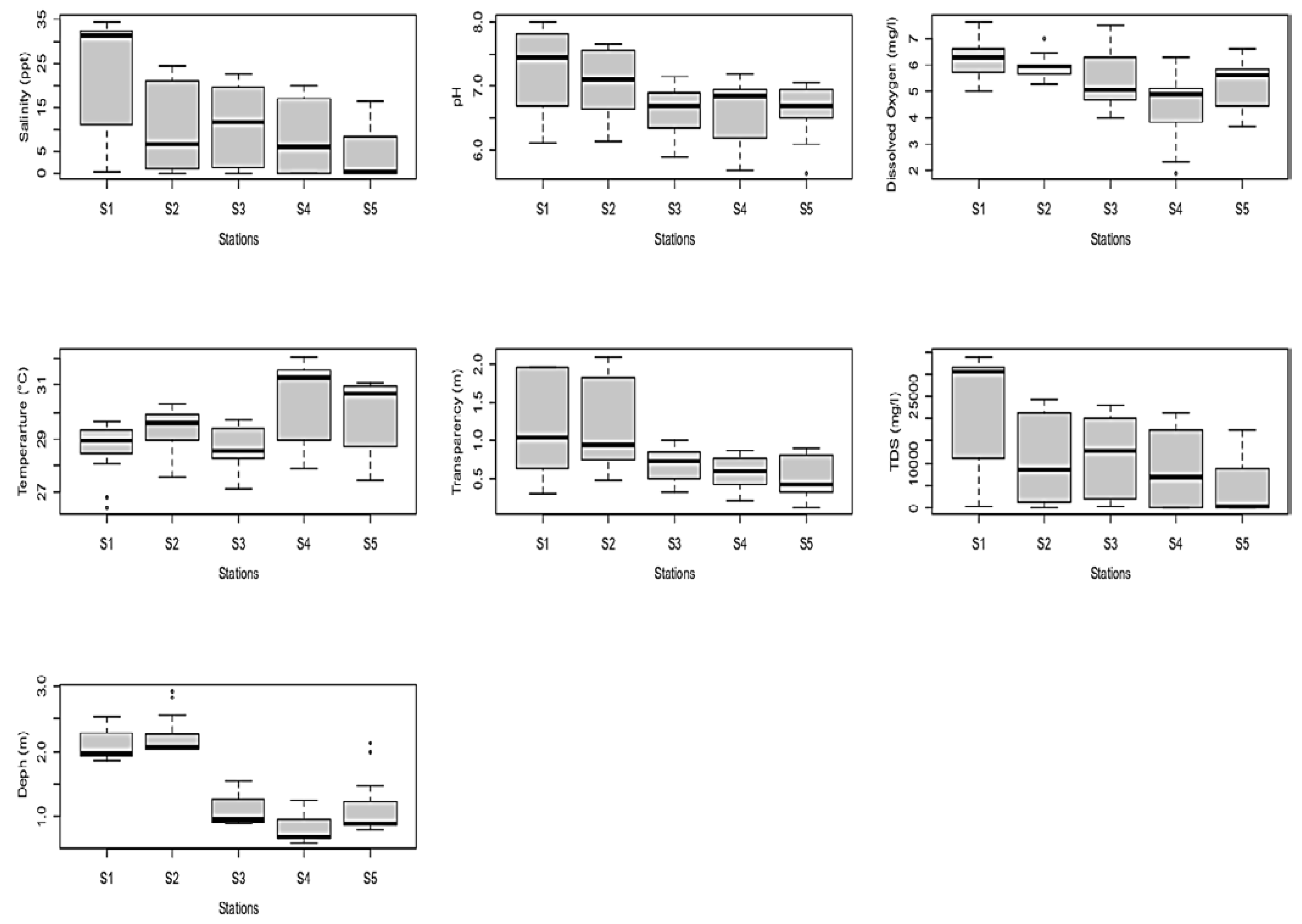
The comparative study of the physical and chemical parameters between the stations, represented in Figure 2 and Table 2 revealed a spatial heterogeneity of the environmental variables:
-
The annual mean highest and lowest values of salinity, transparency and TDS were observed in the south (station S1, near the Atlantic Ocean) and east of Lake Nokoué (station S5, near the Ouémé River) respectively. It is also noted that the largest and smallest fluctuations, computed as the difference between the maximum and minimum values over the year, in salinity and TDS were observed in the south and east respectively, and the largest fluctuations in transparency were observed in the south and center (station S2) of Lake Nokoué.
-
The absolute highest and lowest pH values were recorded in the south (station S1) and north (station S4) of Lake Nokoué respectively. However, the highest and lowest pH fluctuations were recorded in the south (station S1) and east (station S5) of Lake Nokoué.
-
The annual mean highest and lowest dissolved oxygen levels were recorded in the south (station S1) and north (station S4) of Lake Nokoué respectively. It should be noted that the highest fluctuations in dissolved oxygen levels were recorded in the north (station S4) where the sampling station is located in an area close to the Sô River, and with a high concentration of the water hyacinth Eichhornia crassipes during the flood. The lowest fluctuations in dissolved oxygen were observed in the center (station S2) of Lake Nokoué where the concentration of Acadjas is lower than in the western zone.
-
The highest and lowest annual mean temperature values were recorded in the north (station S4) and west (station S3) of Lake Nokoué, while the highest and lowest temperature fluctuations were recorded in the north (station S4) and south (station S1) of Lake Nokoué respectively.
-
The highest and lowest mean water level values were recorded in the center (station S2) and north (station S4) of Lake Nokoué respectively, while the highest and lowest water level fluctuations were recorded in the east (station S5) and north (station S4) of Lake Nokoué respectively. The average annual mean depth of Lake Nokoué for the 5 stations was 1.47 ± 0.66 m.

3.1.2. Temporal Fluctuations of Environmental Variables

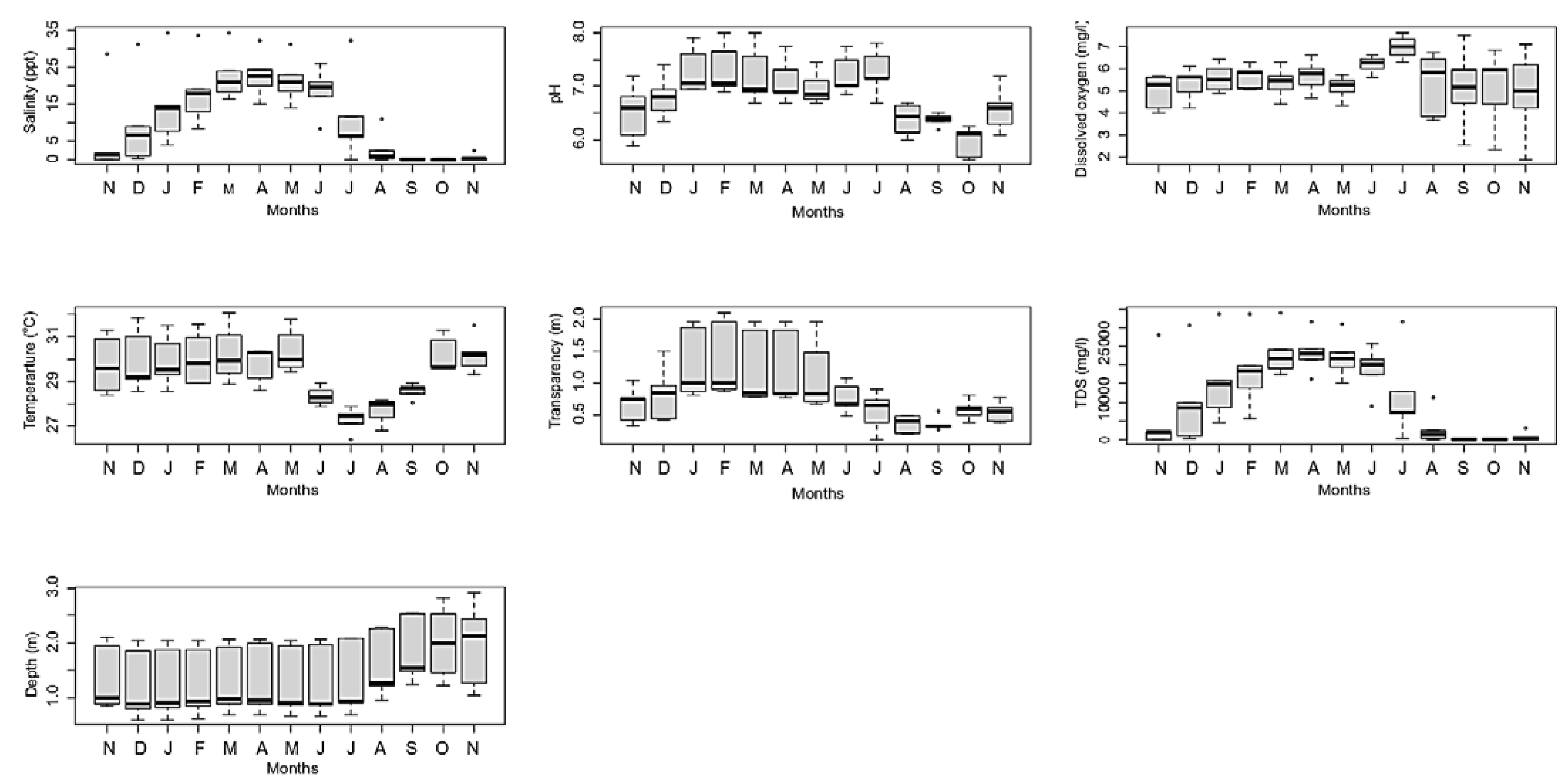
The seasonal monitoring of physical and chemical parameters showed that, on average over all stations, the highest values of salinity, TDS and transparency were recorded in Lake Nokoué from December to June (low water period) while the lowest values were observed from July to November (flood period) (Figure 3). The highest pH values were recorded from December to July (low water period) while the lowest pH values were observed from August to November (flood period). The highest dissolved oxygen values were observed in Lake Nokoué only in July. However, the dissolved oxygen level showed strong variations between stations from August to November. Low temperatures in Lake Nokoué were recorded from June to September, while the temperature of Lake Nokoué varied greatly between stations from November to March. The lowest water levels in Lake Nokoué were recorded from December to July, while the highest levels were recorded from August to November.
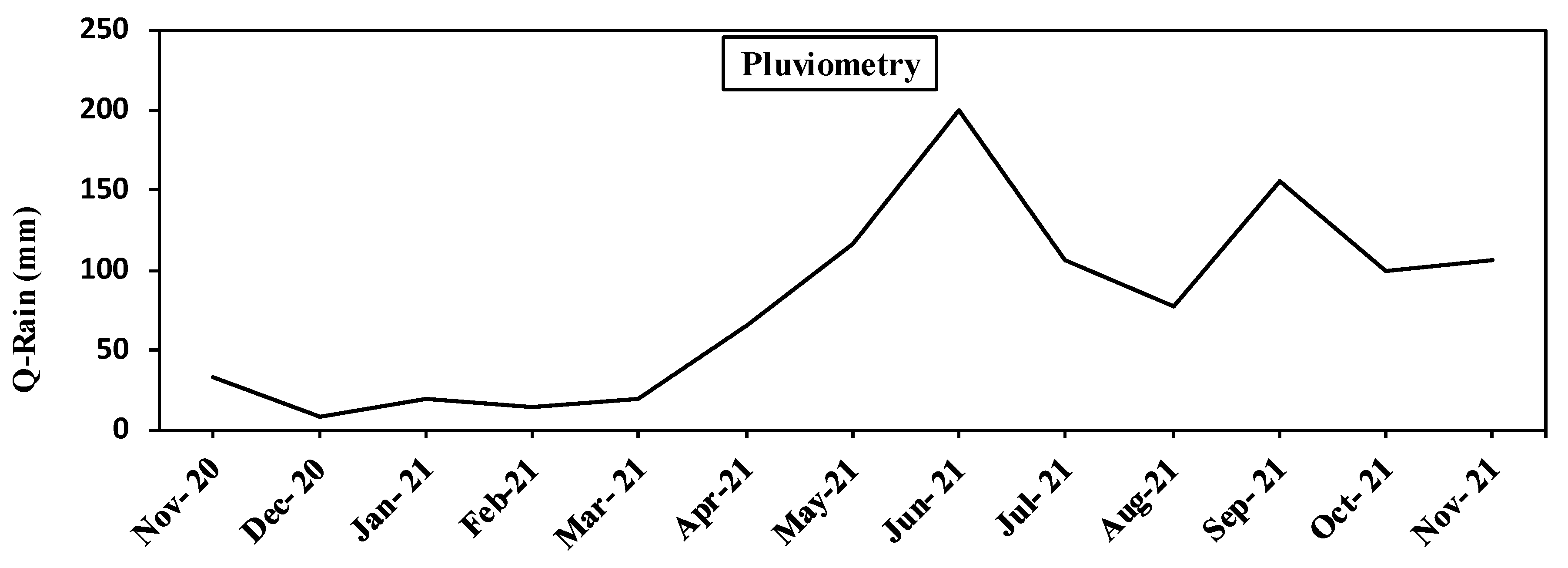
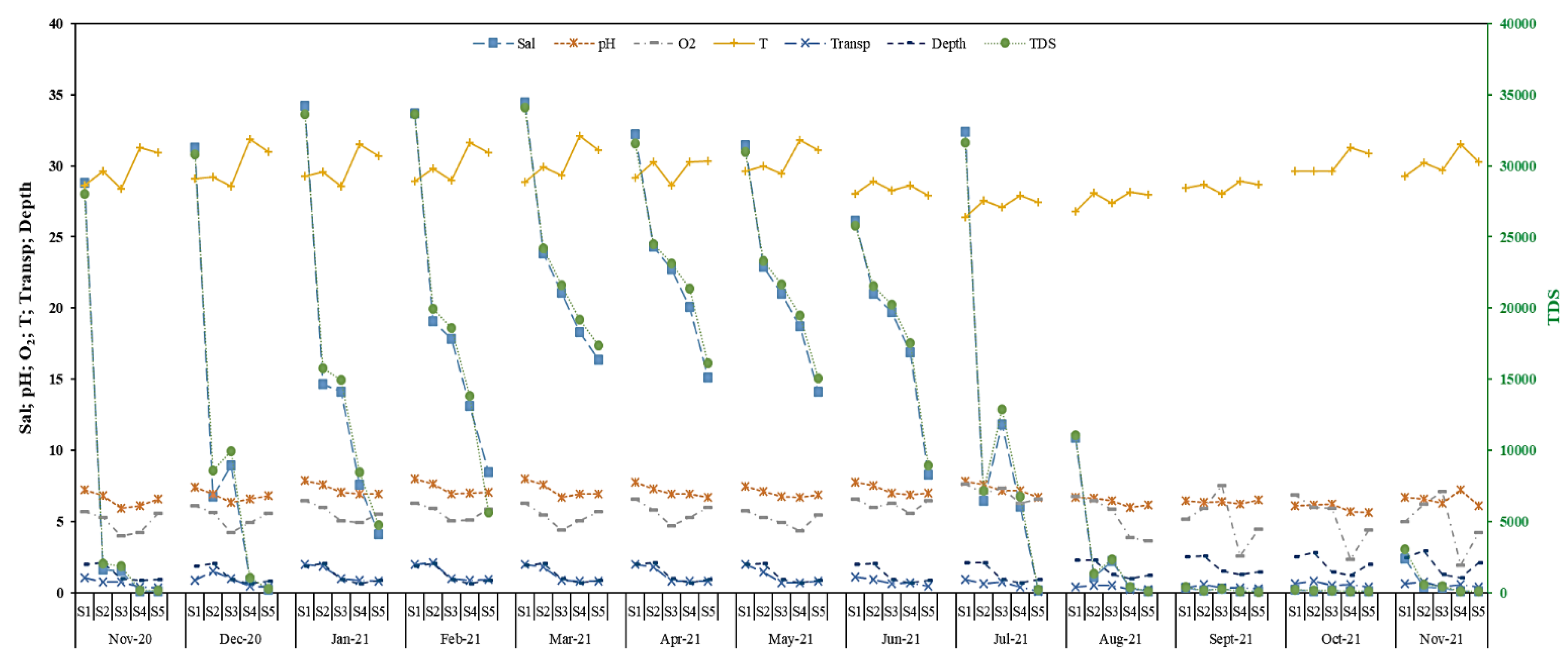
Simultaneous observation of the physical and chemical parameters of Lake Nokoué showed that the lake is mainly characterized by two main regimes: flooding and low water. Comparison of the results of the one-year sampling in the lake with the seasonal evolution of rainfall (Figure 4) showed that the rainy season does not have a direct correlation with the flooding of Lake Nokoué. Indeed, the flood only started in August, while the main rainy season in the sample area was observed in June (Figure 3, Figure 4 and Figure 5). The main factors that influenced the flooding of Lake Nokoué were the entry of water from the Ouémé River (east) and the Sô River (north) into Lake Nokoué (Figure 3 and Figure 5). Thus, there is a progressive decrease in salinity, TDS and water transparency in Lake Nokoué from the east (station S5) to the south (station S1), passing through the center (station 2) of Lake Nokoué. The low water period, characterized by the lowest water level in the lake from December to July 2021, allowed a large intrusion of sea water into Lake Nokoué through the Cotonou (south) inlet. The inflow of sea water progressively affected the southern, central, western, northern and finally eastern stations of Lake Nokoué (Figure 5). During low water, the water in Lake Nokoué is also characterized by an increase in salinity, TDS and water transparency. These variations are potentially at the origin of the great variation in the physical and chemical characteristics of Lake Nokoué.

3.2. Correlation between Physical and Chemical Parameters

Table 3 shows a significant positive correlation between salinity and pH, between pH and water transparency and between TDS and pH. The analysis also shows a highly significant correlation (p < 0.01) between transparency and salinity and between TDS and transparency and a highly significant correlation (p < 0.001) only between salinity and TDS.

3.3. Granulometry of the Sampling Stations

The results of the analysis of the granulometry of the bottom of Lake Nokoué are presented in Table 4.
The analysis of the granulometry samples taken from the bottom of the lake revealed that the soil is strongly rich in sand (97.7%) in the southern part of Lake Nokoué (station S1, exchange zone between Lake Nokoué and the Atlantic Ocean), mainly made up of sand (50.52%) and clay (46.03%) in the center of Lake Nokoué (station S2), strongly rich in clay (92.51%) in the western part of Lake Nokoué (station S3, area with a high concentration of Acadjas and close to the Kpota market), mainly clay (74.74%) and sand (21.15%) in the northern part of Lake Nokoué (station S4, area close to the Sô River) and rich in clay (88.51%) and sand (8.11%) on the eastern side of Lake Nokoué (station S5, area close to the Ouémé River and at the junction with the Porto-Novo coastal lagoon). On average over the 5 stations sampled, the analysis showed that the bottom of Lake Nokoué is mainly composed of clay (60.6%) and sand (36.64%). It also contains 1.71% detritus and 1.002% gravel.

3.4. Variation of the Exchange Surface between the Sea and Lake Nokoué

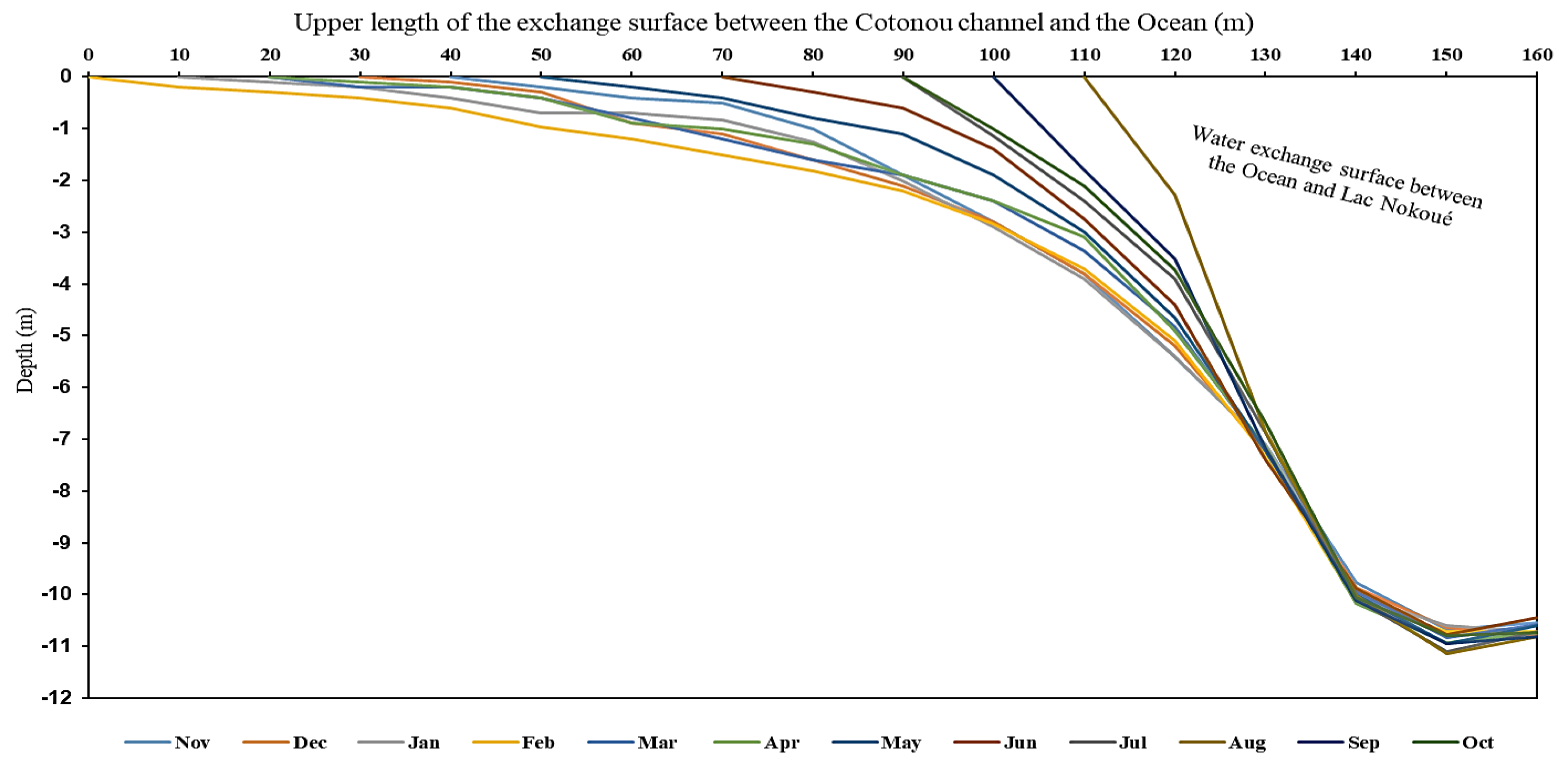
The depth survey of the contact zone between the Atlantic Ocean and Lake Nokoué indicated that the bottom is strongly stabilized by granitic rock spurs. The annual analysis of the exchange surface of the flow zone between the Atlantic Ocean and Lake Nokoué indicated a very stable depth due to the presence of rocks (Figure 6) as well as a strong variation of the upper part of the water exchange surface between Lake Nokoué and the sea depending on the season. The highest depth of the exchange area was 11.15 m. The maximum exchange surface (total width of 160 m) was observed in February, the low water period of Lake Nokoué, during which sea water enters the lake. The direct observation of the processes related to the increase and reduction of the surface of the upper part of the exchange zone, indicated that sand bars are temporarily displaced by the action of the entry and exit movements of the sea in the inlet. These numerous displacements of the sandbars are at the origin of the large variations of the contact zone between the Atlantic Ocean and Lake Nokoué. The smallest exchange surface (total width of 50 m) was observed in August, during the flood period corresponding to the freshwater outflow from the lake to the sea.

4. Discussion

This study confirmed a significant spatio-temporal variation in the physical and chemical parameters measured in Lake Nokoué and the Cotonou inlet. At the spatial level, the results showed a large variation in salinity with a salinity that remains relatively high in the south of Lake Nokoué (near the ocean), while it is relatively low in the other stations (Table 2). The stability of several physical and chemical parameters (pH, O2, transparency), particularly in the stations close to the Atlantic Ocean (south and center), can be explained by the permanent communication with the Atlantic Ocean whose physical and chemical parameters are relatively stable all over the year. Ref. [17], who studied the physico-chemical parameters and macro invertebrate assemblages of Lake Nokoué, also showed seasonal variability and spatial heterogeneity of physico-chemical parameters, which confirm the results of this study. The present work revealed the highest average salinity of 22.9 ppt in April over all five stations. In their study on the seasonal and interannual variability (2017–2019) of Lake Nokoué salinity, Ref. [2] recorded a peak average salinity of 25 ppt in April. The two studies agree on the period during which the average salinity of Lake Nokoué at the time of the peak is highest but differ in the average value of the salinity peak. The difference in the range of average salinity could be due to climatic variability, and in particular the interanual variation of rainfall. Indeed, the flow of freshwater into Lake Nokoué is a function of the amount of rainwater that drains the Ouémé watershed, which varies seasonally and annually. In addition, the variation in lake water level determines the flow of seawater intrusion into Lake Nokoué [2], which also influences the variation in lake salinity. Since the salinity in Lake Nokoué varies in space and seasonally, and shrimps can tolerate different ranges of salinity according to the species, Lake Nokoué shelters a high diversity of shrimps, as showed by [18]. Besides the salinity, other parameters measured in this study such as temperature, pH and dissolved oxygen, are in the range of parameters mentioned in shrimp aquaculture, which would indicate that the water of Lake Nokoué could be suitable for shrimp aquaculture. For example, Ref. [19] considers the salinity range of 16–24 ppt, as observed at station 1, to be the most suitable for Macrobrachium vollenhovenii larvae. On the other hand, incubation of Macrobrachium vollenhovenii eggs was successfully performed by [20] at a temperature of 28 ± 1.5 °C with a dissolved oxygen level of 6 ± 0.5 mg/L and a pH of 7 ± 0.3, which are in the range of values found on average in station 1 and station 2. Given that the most favourable pH for shrimp aquaculture is between 7.5 and 8.5 [21], we estimate that Lake Nokoué, and in particular the southern part (station 1), has ecological advantages over other rivers and coastal lagoon s in the sub-region that are more acidic. For instance, according to [22] who studied the effect of environmental variables on shrimp settlement in four different sites in Côte d’Ivoire (Ayénou 1, Ayénou 2, Dohouan and Macrobo), the pH varied in time and space from 5.49 ± 0.87 to 6.63 ± 0.52. The present study indicates that the highest pH was recorded in the south (pH = 7.32 ± 0.63) while the lowest values were recorded in the east near the Ouémé River (pH = 6.61 ± 0.41), the west (station S3, pH = 6.62 ± 0.37) and the north near the Sô River (pH = 6.63 ± 0.48), which on average is higher than for the sites in Côte d’Ivoire. Furthermore, measurements taken by [23] on the stream of the Sô River located north of Lake Nokoué revealed the following pH, O2 and salinity values: Lower stream near Lake Nokoué (pH = 7.32 ± 0.55; O2 = 6.40 ± 2.67 mg/L; salinity = 1.61 ± 1.42 ppt); Middle stream (pH = 7.10 ± 0.61; O2 = 7.42 ± 2.71 mg/L; salinity = 0.35 ± 0.44 ppt) and upper stream further north of Lake Nokoué (pH = 7.07 ± 0.53; O2 = 7.54 ± 2.53 mg/L; salinity = 0.40 ± 0.63 ppt). These results show that as one moves northward (from Sô River downstream to upstream), salinity and pH decrease and dissolved oxygen levels increase. Since the salinity, temperature, pH and dissolved oxygen values measured in Lake Nokoué are within the range of values favourable for shrimp culture, the water in Lake Nokoué, and in particular that of the Cotonou inlet in which station 1 is situated, could be ideal for the aquaculture of Penaeus shrimp and Macrobachium larvae from December to July. However, due to the high pollution of the lake, we suggest that X-ray disinfection of the water after pumping be performed to eliminate potential pathogens that could contaminate the shrimp culture. The results of the particle size analysis revealed that the bottom of Lake Nokoué is mainly made up of 60.6% clay, 36.64% sand, 1.71% detritus and 1.002% gravel. The high proportion of clay in the bottom of Lake Nokoué could be due to the decomposition of wood that was used to set up the “Acadja” fishing systems. [24] indicated that the complex root networks in the Beninese mangroves function as a real clay trap and we hypothesise that the branches of Acadja wood could also retain clay on the same manner. Furthermore, the results of [3] showed that the very important saline intrusion in the dry season favours the proliferation of tarets (Taredos petiti and Bankia bagidaensis) which contribute to the rapid destruction of Acadja branches. The massive use of Acadjas, which occupy nearly 40% of the surface of Lake Nokoué, combined with rapid degradation of Acadja wood, leads us to fear a progressive filling of Lake Nokoué, which could be accentuated due to the large mass of organic matter resulting from the degradation of water hyacinths. This filling seems to be confirmed when we compare the average annual depth of Lake Nokoué obtained in this study (1.47 m) with the one obtained by [1] which is 1.5 m. However, we suggest further work to better evaluate the variation in depth of Lake Nokoué.

5. Conclusions

The present work has indicated an important fluctuation of the physical and chemical parameters, in particular the salinity and the TDS (total dissolved solids) of the Lake Nokoué-Cotonou inlet complex. We noticed that the flooding period of Lake Nokoué begins one month after the main rainy season, and is linked to the freshwater tributaries of the Ouémé River (east of the lake) and the Sô River (north of the lake). Low water period is characterized by a drop in the water level of Lake Nokoué, due to the decrease in the flow of the Ouémé and Sô tributaries, and the intrusion of sea water into the complex south of Lake Nokoué. The flood is characterized by the desalination of Lake Nokoué from August to November while the low water is characterized by the high salinity of the lake from December to July. Dissolved oxygen concentration varied greatly along the year in the north and west of the lake, which is the zone where water hyacinth (Eichhornia crassipes) concentrates during the flood. The dissolved oxygen and hydrogen potential values recorded are less alarming than expected. Based on the environmental characteristics of the Lake Nokoué, stenohaline species, able to tolerate only a narrow range of salinity, could populate Lake Nokoué during the flood while euryhaline species, able to tolerate a wide range of salinity, would have a favourable environment in the lake throughout the year.

Author Contributions

S.W.S., K.B. and Z.S. contributed to the conception and design of the study. S.W.S. and Z.S. collected the data. S.W.S. wrote the first draft of the manuscript. G.L. contributed to the analysis of the results and the manuscript writing. E.D.F. contributed to the data analysis and the manuscript revision. All authors have read and agreed to the published version of the manuscript.

Funding

This work was funded by the CEBioS program (funded by the Belgian Development Cooperation, DGD).

Institutional Review Board Statement

Not applicable.

Informed Consent Statement

Not applicable.

Data Availability Statement

All data generated and/or analyzed during this study are available from the corresponding author on reasonable request.

Acknowledgments

The authors wish to express their gratitude to Cédric d’Udekem d’Acoz, specialist in crustaceans at RBINS for their advice. The authors also thank Olaègbè Victor Okpeitcha and Alexis Chaigneau for their support in collecting and analysing the granulometry data. This work was partially realized in the frame of the CEBioS program funded by the Belgian Development Cooperation, DGD.

Conflicts of Interest

The authors declare no conflict of interest.

References

  1. Mama, D.; Deluchat, V.; Bowen, J.; Chouti, W.; Yao, B.; Gnon, B.; Baudu, M. Caractérisation d’un système lagunaire en zone tropicale: Cas du lac Nokoué (Bénin). Eur. J. Sci. Res. 2011, 56, 516–528. [Google Scholar]
  2. Okpeitcha, O.V.; Chaigneau, A.; Morel, Y.; Stieglitz, T.; Pomalegni, Y.; Sohou, Z.; Mama, D. Seasonal and interannual variability of salinity in a large West-African lagoon (Nokoué Lagoon, Benin). Estuar. Coast. Shelf Sci. 2022, 264, 107689. [Google Scholar] [CrossRef]
  3. Mama, D. Méthodologie et résultats du diagnostic de l’eutrophisation du Lac Nokoué (Bénin). Ph.D. Thesis, Université de Limoges, Limoges, France, 2010. [Google Scholar]
  4. Welcomme, R.L. An evaluation of the Acadja method of fishing as practised in the coastal lagoons of Dahomey (West Africa). J. Fish Biol. 1972, 4, 39–55. [Google Scholar] [CrossRef]
  5. Lalèyè, P.; Niyonkuru, C.; Moreau, J.; Teugels, G. Spatial and seasonal distribution of the ichthyofauna of Lake Nokoué, Bénin, West Africa. Afr. J. Aquat. Sci. 2003, 28, 151–161. [Google Scholar] [CrossRef]
  6. Feuchtmayr, H.; Moran, R.; Hatton, K.; Connor, L.; Heyes, T.; Moss, B.; Harvay, I.; Atkinson, D. Global warming and eutrophication: Effects on water chemistry and autotrophic communities in experimental hypertrophic shallow lake mesocosms. J. Appl. Ecol. 2009, 46, 713–723. [Google Scholar] [CrossRef]
  7. Badahoui, A.; Fiogbe, E.D.; Boko, M. Les causes de la dégradation du lac Ahémé et ses chenaux. Int. J. Biol. Chem. Sci. 2010, 4, 882–897. [Google Scholar] [CrossRef]
  8. Hu, Z.; Sun, X.; Cai, Y.; Guo, L.; Chen, Q.; Liu, T.; Shi, F.; Yang, L. The habitat type and trophic state determine benthic macroinvertebrate assemblages in lowland shallow lakes of China. J. Limnol. 2016, 75, 330–339. [Google Scholar]
  9. Vennin, A. Etude de l’interface eau-sédiment dans les géosystèmes estuariens: Approchecouplée Biogéochimie et modélisation par l’évaluation des flux de nutriments (C, N, P). Ph.D. Thesis, Normandie Université, Normandie, France, 2018. [Google Scholar]
  10. Frontalini, F.; Armynot du Châtelet, E.; Debenay, J.P.; Coccioni, R.; Bancalà, G. Benthic foraminifera in coastal lagoons: Distributional patterns and biomonitoring implications. In Lagoons: Biology, Management and Environmental Impact; Friedman, G., Ed.; Nova Science Publishers: New York, NY, USA, 2011; pp. 39–72. [Google Scholar]
  11. Schwartz, D.; Lazar, P. Elément de Statistique à L’usage des Étudiants en Propédeutique Médicale; Editions Flammarion: Paris, France, 1964; 142p. [Google Scholar]
  12. Bédard, P. Clef D’identification Visuelle des Roches. 2012–2016. Available online: http://pierrebedard.ca/ (accessed on 14 February 2022).
  13. Boulvain, F. Pétrologie Sédimentaire: Des Roches aux Processus; Technosup; Ellipses: Paris, France, 2010; 259p. [Google Scholar]
  14. Boulvain, F. Eléments de Sédimentologie et de Pétrologie Sédimentaire; Université de Liège, Faculté des Sciences, Département de Géologie: Liège, Belgium, 2021. [Google Scholar]
  15. Legendre, L.; Legendre, P. La Structure des Données Écologiques. Ecologie numérique, Tome 2; Masson: Paris, France, 1984; 335p. [Google Scholar]
  16. Sharma, K.N.M. Légende Générale de la Carte Géologique; Direction générale de la géologie, Ministère des Ressources naturelles: Québec, QC, Canada, 1996; 89p. [Google Scholar]
  17. Odountan, O.H.; Janssens de Bisthoven, L.; Koudenoukpo, C.Z.; Abou, Y. Spatio-temporal variation of environmental variables and aquatic macroinvertebrate assemblages in Lake Nokoué, a RAMSAR site of Benin. Afr. J. Aquat. Sci. 2019, 44, 219–231. [Google Scholar] [CrossRef]
  18. Sintondji, S.W.; Gozingan, A.S.; Sohou, Z.; Taymans, M.; Baetens, K.; Lacroix, G.; Fiogbé, E.D. Prediction of the distribution of shrimp species found in southern Benin through the lake Nokoué-Ocean complex. J. Aquac. Mar. Biol. Ecol. 2022, 116. [Google Scholar] [CrossRef]
  19. Willführ-Nast, J.; Rosenthal, H.; Udo, P.J.; Nast, F. Laboratory cultivation and experimental studies of salinity effects on larval development in the African river prawn Macrobrachium vollenhovenii (Decapoda, Palaemonidae). Aquat Living Resour. 1993, 6, 115–137. [Google Scholar] [CrossRef] [Green Version]
  20. Sintondji, S.W.; Adjahouinou, C.D.; Djihinto, G.A.; Fiogbe, E.D. Embryology of African giant freshwater shrimp Macrobrachium vollenhovenii. Biologia 2020, 75, 93–101. [Google Scholar] [CrossRef]
  21. Zweig, R.D.; Morton, J.D.; Moral, M.S. Source Water Quality for Aquaculture: A Guide for Assessment; Environmentally and Socially Sustainable Development; The World Bank: Washington, DC, USA, 1999; 76p. [Google Scholar]
  22. Claver, K.D.; Mamadou, B.; Mexmin, K.K.; Gervais, K.N.Z.; Gouli, G.B.; Tidiani, K. Peuplement de la faune de crevettes de la Forêt des Marais Tanoé-Ehy (Sud-Est de la Côte d’Ivoire). J. Appl. Biosci. 2017, 112, 11100–11110. [Google Scholar] [CrossRef]
  23. Koudenoukpo, Z.C.; Chikou, A.; Adandedjan, D.; Hazoume, R.; Youssao, I.; Mensah, G.A.; Laleye, A.P. Caractérisation physico-chimique d’un système lotique en région tropicale: La rivière Sô au Sud-Bénin, Afrique de l’Ouest. J. Appl. Biosci. 2017, 113, 11111–11122. [Google Scholar] [CrossRef]
  24. Gaillard., M.; Gaillard, M.; Lang, J.; Lucas, J. Étude sédimentologique des milieux de mangrove du Bénin occidental (Afrique de l’Ouest). In Proceedings of the Actes Symposium International sur les Lagunes Côtières, SCQR/IABQ/UNESCQ, Bordeaux, France, 8–14 September 1981; pp. 129–137. [Google Scholar]
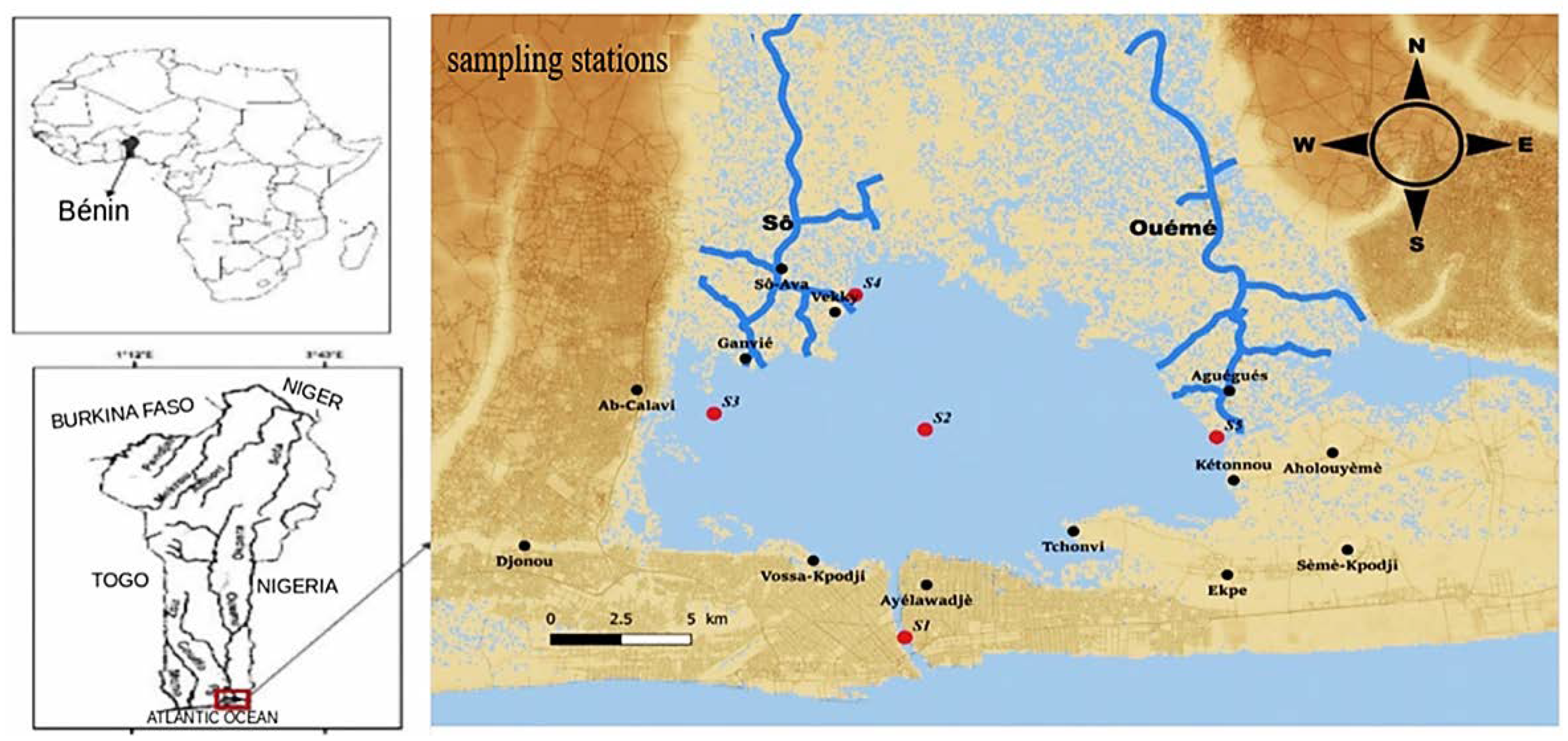
Figure 1. Geographical location of Lake Nokoué in West Africa, south of Benin. The red dots indicate the stations.
Ecologies 03 00033 g001
Figure 2. Spatial fluctuations (annual average) of environmental variables at the different stations, S1: south, S2: centre S3: west, S4: north, S5: east. See Figure 1 for positions of these stations.
Ecologies 03 00033 g002
Figure 3. Seasonal fluctuation of environmental variables.
Ecologies 03 00033 g003
Figure 4. Rainfall in the south of Benin (http://www.meteobenin.bj (accessed on 1 June 2022)).
Ecologies 03 00033 g004
Figure 5. Seasonal evolution of environmental variables in the five stations (S1–S5 from left to right) of Lake Nokoué- inlet complex. Sal = Salinity (ppt); pH = Potential Hydrogen; O2 = Dissolved Oxygen (mg/L); T = Temperature (°C); Transp = Transparency (m); TDS = Total Dissolved Solids (mg/L); Depth = Water depth (m).
Ecologies 03 00033 g005
Figure 6. Variation of the exchange surface between the sea and Lake Nokoué.
Ecologies 03 00033 g006
Table 1. Characteristics of the sampled stations.
EcosystemsStationsPositionDepthCoordinates
LatitudeLongitude
InletS1South1.95 m06°21′55.86″ N02°26′23.47″ E
Coastal lagoonS2Center2.10 m06°26′22.87″ N02°26′46.87″ E
Coastal lagoonS3West1.00 m06°26′43.26″ N02°22′43.78″ E
Coastal lagoonS4North (Sô river entrance)0.86 m06°29′15.57″ N02°25′26.29″ E
Coastal lagoonS5East (Ouémé river entrance)0.90 m06°26′13.04″ N02°32′22.59″ E
Table 2. Annual mean and standard deviation of the different parameters at the 5 stations.
SalpHO2TTranspTDSDepth
S122.95 ± 13.947.32 ± 0.635.92 ± 0.4628.62 ± 1.001.19 ± 0.6522,685.48 ± 13,612.202.08 ± 0.25
S210.95 ± 10.157.05 ± 0.515.92 ± 0.4629.33 ± 0.821.19 ± 0.5811,479.16 ± 10,246.242.21 ± 0.29
S310.90 ± 9.096.62 ± 0.375.56 ± 1.2028.61 ± 0.810.7 ± 0.2211,398.08 ± 9299.131.06 ± 0.26
S410.9 ± 9.096.63 ± 0.484.33 ± 1.3330.52 ± 1.550.57 ± 0.218343.77 ± 8744.740.80 ± 0.24
S55.18 ± 6.486.61 ± 0.415.34 ± 0.8929.94 ± 1.380.51 ± 0.275294.22 ± 6825.211.09 ± 0.41
Sal = Salinity (ppt); pH = Potential Hydrogen; O2 = Dissolved Oxygen (mg/L); T = Temperature (°C); Transp = Transparency (m); TDS = Total Dissolved Solids (mg/L); Depth = water depth (m).
Table 3. Correlation matrix between the environmental variables on all five stations.
SalpHO2TTranspTDSDepth
Sal--0.79 *0.30−0.100.80 **1.00 ***−0.02
pH --0.44−0.090.73 *0.78 *0.02
O2 --−0.420.180.320.33
T --0.15−0.11−0.31
Trans --0.80 **0.11
TDS --−0.02
Depth --
The degree of significance of Spearman Rank correlations is marked by the stars. * (p < 0.05, significant correlation), ** (p < 0.01, highly significant correlation), *** (p < 0.001, highly significant correlation). Sal = salinity (ppt); pH = potential hydrogen; O2 = dissolved oxygen (mg/L); T = temperature (°C); Transp = transparency (m); TDS = total dissolved solid (mg/L); Depth = water depth (m).
Table 4. Percentage of sediment type in Lake Nokoué and the Cotonou inlet. See Figure 1 for the position of the five sampling stations.
CodeClay (%)Detritus (%)Sand (%)Gravel (%)
S11.230.0197.700.82
S246.032.1750.520.99
S392.510.245.721.71
S474.743.4821.150.52
S588.512.678.110.97
Publisher’s Note: MDPI stays neutral with regard to jurisdictional claims in published maps and institutional affiliations.