Article

History, Colonialism, and Archival Methods in Socio-Hydrological Scholarship: A Case Study of the Boerasirie Conservancy in British Guiana

Department of Culture and Economy, Wagner College, Staten Island, NY 10301, USA
World 2020, 1(3), 205-215; https://doi.org/10.3390/world1030015
Submission received: 20 August 2020 / Revised: 22 September 2020 / Accepted: 9 October 2020 / Published: 13 October 2020

Abstract

:
In this article, I review a cross-section of research in socio-hydrology from across disciplines in order to better understand the current role of historical-archival analysis in the development of socio-hydrological scholarship. I argue that despite its widespread use in environmental history, science and technology studies, anthropology, and human geography, archival methods are currently underutilized in socio-hydrological scholarship more broadly, particularly in the development of socio-hydrological models. Drawing on archival research conducted in relation to the socio-hydrology of coastal Guyana, I demonstrate the ways in which such scholarship can be readily incorporated into model development.

1. Introduction

In their pioneering text Fluvial Processes in Geomorphology, Leopold, Wolman, and Miller state that “a river or drainage basin might best be considered to have a heritage rather than an origin. It is like an organic form, the product of a continuous evolutionary line through time” [1] (p. 412). In this article, I argue that their geomorphological argument—that the lithology and structure of aquatic flows is firmly rooted in the geological history of the larger basin in which it exists—can and should be extended to include the social life of rivers and coastal zones, that doing so opens up a large collection of potential data about hydrological systems, and that this has important implications for hydrological modelling. For Leopold et al. the problem was disassociating the “effects of climate from those of man’s activities” [1] (p. 390), a goal rendered impossible—or at the very least unrealistic—by current understandings of the increasingly complicated and integrated nature of human-natural worlds and giving rise to a need critically consider fully the human role in physical geography [1,2,3].
This article represents one attempt at addressing this need by demonstrating that one of the dominant approaches to understanding the relationship between society and the physical environment—socio-hydrology—can benefit by incorporating historical data and critical analyses of colonialism into current approaches. Through a critical review of the extant literature on modelling in and for socio-hydrology I argue that rather than attempting to distinguish between human and climatological or geophysical effects, current approaches to socio-hydrology require careful consideration of the role of human structures and infrastructures which likewise shape local topographies, geomorphologies, and surface water dynamics, particularly in riverine and coastal zones. Socio-hydrology differs from other hydrological approaches in its focus on the outcomes—both short-term and long-term—of water management. It brings into focus the ways in which water management has been shaped by political, economic, and social conditions happening around it [4]. However, research in socio-hydrology has yet to systematically engage with longer histories of environmental intervention and the continued relevance of these histories to social systems [5,6]. The heritage of a river, in other words, is just as much about its patterns of accretion and erosion, its meanders, cuts, floods, and sediment sinks as it is the dams, locks, levees, walls, groins, and the other infrastructures that have been developed in an attempt to bring water in line with human social, political, and economic desires. It is similarly necessary to understand why these interventions took place, rather than assume they were a necessary part of human survival in these regions. Drawing on a case study of coastal Guyana, I likewise argue that, through the archival interrogation of past forms of aquatic control, scholars interested in socio-hydrology broadly and socio-hydrological modelling in particular have access to a veritable treasure trove of evidence for use in better understanding the socio-natural lives of rivers and coastal zones.
With this comes the caveat that archives and collections are repositories only of certain knowledges, histories, and practices and that researchers working within them must understand the broader contexts in which they were produced. Archives are not factual databases of reliable information but sites through which colonial administrators and archivists ordered knowledge [5]. In the case of the archives discussed here, they did this as part of a broader project of the epistemological subjugation of the majority of the Earth’s inhabitants through processes of colonial cultural erasure [5]. This is especially true of archival information preserved in relation to geological and hydrological studies. As Yusoff argues, geology—and by extension hydrology—has been a key science in service of this subjugation. Geology and the production of geological knowledge has been “a mode of accumulation, on one hand, and of dispossession, on the other, depending on which side of the geological color line you end up on” [5] (p. 3). Examining archival materials requires a deeper understanding of the racialized political economies in which past environmental knowledge was produced and is best understood in a broader historical and scholarly context that includes and highlights local knowledge. As I demonstrate further below, one cannot passively or neutrally consider the truths they offer.

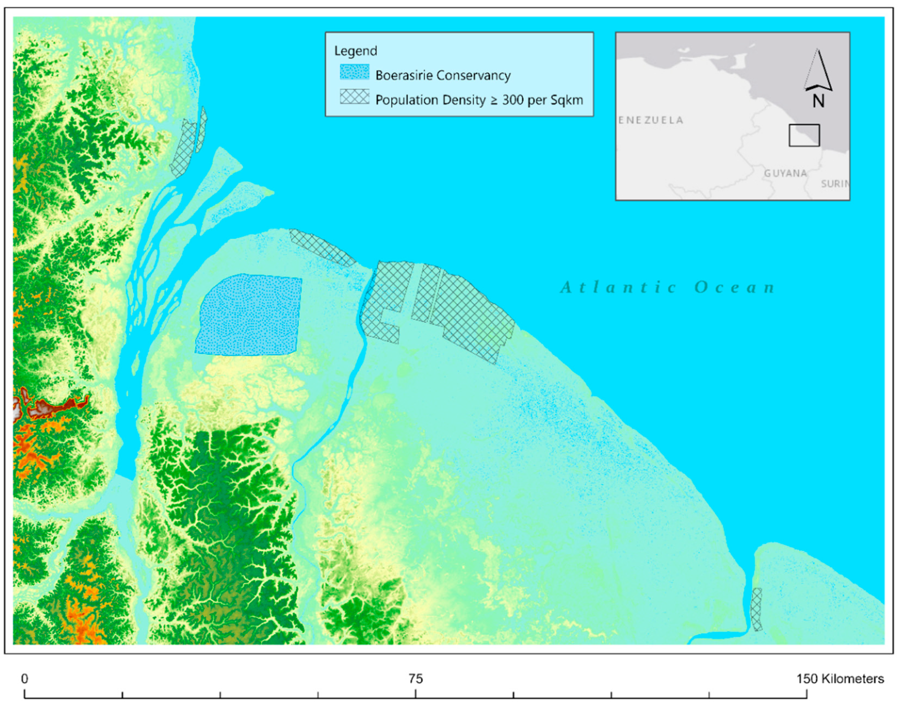
Description of the Study Area

Situated along South America’s North Atlantic coast, ninety percent of Guyana’s population lives in the country’s coastal zone, a narrow strip making up only about four percent of the available land in the country (Figure 1). Much of this coastal plain sits near, or in some areas below, sea level and is punctuated by a system of four large rivers (Essequibo, Demerara, Berbice, Corentyne) and a network of dozens of smaller rivers all being fed from the country’s mountainous and densely forested uplands. The coastal plain itself is the result of a combination of the fluvial geomorphological processes associated with these rivers and a series of northwesterly flowing mudbanks originating in the delta of the Amazon River and continuing to the delta of the Orinoco River in Venezuela [7]. Coastal muds were collected in this low-lying area through processes of flocculation, siltation, and bed accretion in mangrove forests that have now largely been removed [8,9]. Without mangrove forests, the cycles of erosion, accretion, and migration commonly associated with mud coasts are largely handled by groynes, riprap, and seawalls installed during the British colonial period, and particularly following a major flood event in 1855 which washed away large segments of the coastal landscape.
The coastal population density of this area is the result of a long history of colonial economic development between the 1790s and 1950s focused primarily on the production of sugar and, during the latter period, rice for the global agricultural commodity market, a process reflected also in a coastal demography in which the vast majority of the population are descended from enslaved Africans and indentured South Asians [10]. In order to support this agricultural economy, planters and later colonial engineers developed a system with over 4000 miles of canals, hundreds of miles of sea wall, and water conservancies to regulate the flow of water through populated areas, to minimize flood risk, and to maximize profits [10,11,12].
This history of coastal development is important for several reasons. First, as shown above, coastal water management systems are developed with a variety of sometimes contradictory logics which need to be understood just as much as the local watershed dynamics in order to situate and inform socio-hydrological models. In Guyana, this has typically fallen along political, economic, and, relatedly, racial lines. Second, when considering the archives as a source of data to fill in models, understanding why measurements were taken, where they were taken, and what has changed since they were taken are important considerations. The mere existence of numbers in the archive is not enough alone for filling in data.

2. Materials and Methods

I reviewed a cross-section of the extant literature in socio-hydrology, focusing on research problems in data sparsity, modelling, and historical research. This review was not meant to be systematic nor to cover the entire breadth of the literature on these topics, but instead to highlight some of the myriad ways in which historical materials and methods are currently used in socio-hydrological research (broadly defined) while also identifying specific areas where historical documentary analysis may make important new contributions. Articles were found through keyword searches in both Google Scholar and Web of Science, with keywords focused on history (including the term archive) and socio-hydrology. I reviewed article abstracts for relevance and selected the included articles based on their arguments about and (dis-)use of historical data and their ability to represent some of the various issues faced by researchers in the varied fields that utilize and rely on socio-hydrological systems analysis. The research is limited to surface hydrology both because of the content of the included articles and the limitations of the case study. While researchers might apply some of the ideas here to hydrological modelling more broadly, I will not be specifically addressing those uses in this article.
In the results section of the article, I draw on my own research conducted on and in the coastal zone of Guyana in order to demonstrate the potential application of archival analysis in two ways: first, as a means for understanding the logic behind past interventions and, second, as a way to address data sparsity based on archival research conducted between 2015 and 2017 in London, UK, and Georgetown, GY, and Gainesville, FL, USA. The specific methods used to collect, collate, and otherwise parse this data varied both by the location and organization of the archive as well as the time period of the research. I expect that this will be the case in other situations as well and want to note that it is important to recognize that historical research methodologies are necessarily variable, contingent, and best developed in relation to the particular cases, archives, and materials researchers are using. In London and Gainesville, materials were located using the digital catalog of the repositories. As part of a much larger research project, search terms were related to a variety of issues related to flooding, infrastructure, and agriculture in British Guiana. In Georgetown, materials were provided directly by the archivist based on a description of the project. In all cases, the materials were digitized. Digital images of documents were entered into qualitative data analysis software where they were coded by subject matter. Documents across various archives were then able to be recompiled based on these subject codes in order to better understand the connections between specific projects and the broader social, political, and economic issues facing the colony.

History and Historical Data in Socio-Hydrological Research and Modelling

Helmreich calls water a “theory machine,” an object that through its widespread significance serves as a means of stimulating insights into the lives and livelihoods of the people and places around it [13]. Understanding how people do and do not control water provides valuable and translatable insights into who they are as a people, which shapes how they control water, a sentiment that resonates with early anthropological insights into water management such as those from Geertz, Lansing, and, more recently and in the context of hydrological modelling, Lansing et al. [14,15,16]. Hill has gone as far as to argue that a typology of past water control projects may provide ideas and insights into the application of new technologies in similar geological and hydrological contexts [17]. However, these projects are imminently social, and as a result, such typologies run the risk of ignoring the social contexts in which certain projects were produced and the social worlds they helped to create. Lave et al. argue that this gap can be overcome through the implementation of what they call “critical physical geography” [18]. For Lave and colleagues, scientists cannot rely on only critical social science or abstracted physical studies “because socio-biophysical landscapes are as much the product of unequal power relations, histories of colonialism, and racial and gender disparities as they are of hydrology, ecology, and climate change” [18] (p. 3). In work representative of this idea, Barnes, for example, highlights the ways in which the maintenance of irrigation infrastructure used to create arable land along the Nile has also created sets of social relationships that in turn shape and maintain the regional material and social order [19]. Similarly, Choi [20] shows how land reclamation projects in South Korea’s tidal flats—which were discursively defended as modernization projects—contributed to regional underdevelopment by alienating rural workers from the economic growth being experienced in more urbanized areas. D’Souza takes this even further, arguing that British understandings of Indian water are best understood through an understanding of “colonial hydrology,” whereby the most basic knowledge about and interventions in water systems were intimately tied to the British’s role as colonizers [21].
While these social scientific approaches have focused on the ways in which political and economic histories have shaped physical environments, within socio-hydrological scholarship there has been a focus on technical limitations and the continued presence of past action (what policy researchers call path dependency [22,23]). However, historical research has itself has been scant and limited to brief narratives accompanying relatively simple quantitative analyses [24]. Through a systematic review of research in socio-hydrology and hydrosocial research more broadly, Wesselink, Kooy, and Warner argue that “what distinguishes socio-hydrology […] is the attempt to capture all human-nature interactions in a mathematical, holistic system model by means of mathematical expressions” [24] (p. 3). This difference is highlighted to some extent in the normative commitments of prominent bodies of socio-hydrological research [17]. Wescoat notes how the duty of water ideas which shaped early socio-hydrological interventions (including “standards” and “values” which can and often did have quantitative measures and which in turn produced their own standards of what could be considered “normal” water use) had been replaced by “more precise standards of water use efficiency” [25] (p. 4579). Thus, in both duty of water approaches and later techniques for model development, quantifiable measurements take a central and normative role while the reasons for how and why these standards and practices developed and how they were subsequently implemented went largely unquestioned. This creates a difficult problem where qualitative, contingent, and otherwise narrative forms of data must be quantified, even heuristically, in order to fit within socio-hydrology’s mathematical ontology and where nuances about the origins and negotiations within environmental expertise are left as secondary bits of context [25].
The focus on mathematical modelling produces several areas of potential improvement in socio-hydrological research. Coles et al., for example, conduct an analysis of the ability of emergency service operators to respond to care facilities within legally mandated response times during simulated flood events in York, UK [26]. Using a FloodMap model that combines hydrological and infrastructural network data, they show how floods can have cascading effects well beyond the geographical sites of flooding. Flooding impacts on emergency services in the region affected emergency service operations in nearby facilities, forcing a 39% increase in the coverage areas of emergency responders not directly impacted. Yin et al. conducted a similar FloodMap modelling-based study in Manhattan, New York City, USA, and found similar results [27]. The results of these modelling analyses highlight the potential social and political implications of socio-hydrological modelling but also the limitations of these models through their exclusion of data that might be considered historical in nature. For example, Yin et al. compare simulated New York Police Department (NYPD) response times in both normal and flood conditions, but a recent report by the New York City Independent Budget Office (IBO) shows how response times can vary significantly in normal conditions with largely African-American precincts in the Bronx and central and eastern Brooklyn having higher than normal response times than neighboring precincts [27,28]. While the IBO does not attempt to explain these variations, additional research into the social and economic makeups of neighborhoods could be correlated with historical response times within these precincts and used to better create response-time simulations in the FloodMap model.
Forsee and Ahmed likewise focus on flooding and infrastructure to show how regional climate models can be used to highlight shortcomings in existing storm-water drainage infrastructure in Las Vegas, increasing the risk of flooding in the city [29]. Combining regional climate models and the Army Corps of Engineering Hydrologic Engineering Center’s Hydrologic Modeling System, they show climate change will necessarily impact storm-water infrastructure design. O’Connell and O’Donnell used coupled human and natural system modelling to highlight the potential risks posed by delaying such investments as well as to highlight the areas where interventions can have the greatest impact [30]. Missing from both of these examples is a historical understanding of the reasons why infrastructures are developed where they are, when they are, and how they are maintained and modified in the years following their construction. This is important because infrastructure projects were not produced in a vacuum. Colten for example notes how Jim Crow policies directly impacted the areas in which the black population of New Orleans could live, areas which relied heavily on water infrastructure and which, in the wake of Hurricane Katrina, were producing significant exposure risks in the social calculus of a hydrological disaster [31,32]. In a different context, Barnes highlights the ways in which infrastructural maintenance is used to produce and reproduce material inequalities which directly affect individual experiences with water [19].
Though offering critical insights into the potential future impacts of floods, these modelling-based studies take for granted both the construction of vulnerable flood subjects and the histories of infrastructure and environmental management that shape these vulnerabilities [33,34,35,36]. As a result, the social inequalities and operations of power which produce vulnerability to floods go ignored. Flood infrastructure—which may be considered to include storm-water drainage systems—produces and reproduces material inequalities between populations, particularly in urban areas [35,36]. As Batubara, Kooy, and Zwarteveen argue, the technical and value-neutral language used in the examples above can be used to justify or obscure highly political decision-making processes through which new vulnerabilities are produced while existing ones are made more concrete [36]. As technical practices (i.e., modelling) continue to be offered to governments and emergency management teams as an easy solution to flood risk problems, understanding the inequalities which may be embedded in them and the ways in which they might produce new inequalities becomes vital to understanding how they might be framed, considered, and applied [37,38]. This is especially important as scientists and policy-makers begin to move toward resilience-based approaches to coastal flood management which rely on both implicit and explicit analysis of social vulnerabilities and turn to socio-hydrological models in order to at least partially inform their analyses [39,40].
In the following section, I highlight some of the ways that historical research can be used to understand these vulnerabilities and better shape the technical practices used to inform hydrological decision-making in order to avoid producing new vulnerabilities or reproducing existing ones. This is done, I argue, by drawing on archival materials which contain detailed accounts of flood events, insights into past interventions, and historical hydrological data, all of which can be used to create more effective socio-hydrological models and better frame model outputs.

3. Results

Case Study: History and the Socio-Hydrology of the Boerasirie Conservancy

In the remainder of this section, I will draw on Beer and Bacchus’ study of the Boerasirie Conservancy in coastal Guyana [41] (Figure 1). Their study, meant to aid in the development of water management and use practices in the area of the Boerasirie and East Coast Demerara conservancies, relies on a computerized water balance model based largely on hydrometerological data collected daily over the period of one year, previous daily records to check for appropriateness, as well water infrastructure in the broader conservancy catchment area. Though an older study and thus also an older model, it serves as an ideal entry point for thinking about the ways in which archival resources might make for richer models. As they note, more water level records could be used to improve the model. Here, I suggest that not only could some of this information be used but so could a better understanding of the historical use practices in conservancy, including modifications made to reduce the impacts of droughts during a period of large-scale infrastructure management and land settlement projects from the 1920s to the 1950s.
The Boerasirie scheme is in the Essequibo Island-West Demerara region (Region 3). Completed in its current form in 1950, the conservancy stores waters from the Boerasirie river, feeding the irrigation canals for more than 40,000 hectares of the country’s sugar and rice producing areas, and has a capacity of 165.7 m3 and covers 94 square miles. The estates and villages lining the coast of the West Coast Demerara region have historically relied upon the Boerasirie Water Conservancy, situated in the backlands between the Demerara and Essequibo rivers. However, inefficient design and poor soil conditions made the conservancy inadequate for supporting both large-scale agricultural production and village settlement. From November 1899 to January 1900 a severe drought left villages in the area of the conservancy in a situation whereby “pure drinking water was mostly unobtainable, most of the villages having nothing better than a supply of liquid mud taken from the trenches or ponds, often far distant. [While] on the Sugar estates, the water Supply considering the long and severe strain thrown upon it, till [sic] the end of the drought on 1st January 1900 was wonderfully good” [42] (p. 64).
Though this was complained about among the planters and villagers relying on it for decades, this inadequacy became painfully clear in 1937, when according to the narrative of the project application a drought left the conservancy dry for a period of 42 days [43]. The lack of water caused dam walls of the previous conservancy project (mostly made out of local, peaty soil) to shrink or collapse, leaving the areas adjacent to the conversancy vulnerable to flooding when the seasonal rains returned. Similarly, nearby Canals Polder Conservancy, though much smaller in size and meant to provide water for a much smaller area, caused regular experiences of drought and flood in the area of Canals Polder on the west bank of the Demerara River [43].
These problems with the Boerasirie Conservancy were first addressed by the Bonasika scheme, which created a canal from the Bonasika river to the conservancy to provide it with a regular infusion of fresh water even in times of regular drought. The Bonasika River, being fed from the forested highlands in the country’s interior, was not ever likely to run dry enough to be unable to recharge the conservancy. However, shortly after the scheme was completed, heavy rainfalls threatened to undermine the headworks, which resulted in the project’s early abandonment [43]. So severe was the damage that, in his notes of a tour of the decimated scheme, J.W. Vernon of the Colonial Office stated that “the water rushing through these headworks had scoured back so fiercely under the greenheart pile foundation that the diver who examined them was able to walk right underneath the whole structure” [44] (p. 1). These issues, including water problems in Canals Polder, were to be addressed by the general refurbishment of the existing Boerasirie scheme, which would, according to colonial legislators, also bring about thousands of new acres of arable land which could be worked by re-settled East Indian laborers, with the potential to grow a variety of crops [45]. Despite its failures, the use of the existence of new inflows into the conservancy as part of the Bonasika scheme along with the prospect of being able to incorporate that infrastructure into the new project made it attractive for land settlement as it would allow the project to be completed more quickly and at lower costs, bringing a relatively happy end to “a long sad story of yet another very heavy over-expenditure on a British Guiana Drainage and Irrigation Scheme” [46] (n.p.).
Encompassing an area of 129,000 acres (201 square miles) with 97,000 acres available for cultivation, the refurbishment of the Boerasirie scheme was an absolutely massive undertaking (Figure 1). While initially calculated to include not only support for rice and sugar but also for the ground staples common to the already existing African villages in the region, early reports on the economic prospects of the Boerasirie scheme quickly noted that the majority of the newly established arable lands would be used to develop the rice industry, while sugar expansion would be focused on the area of Wales Estate, West Bank Demerara [47]. This was due largely to concerns that the growth of non-cash crops would not provide the economic returns that cash crops (especially rice) could offer. One administrator made this point bluntly, stating that “Leaving aside engineering, the doubtful part of the scheme from the technical aspect is the direction of agricultural developments. Unless the land is in fact developed with crops that pay, it will not be possible to charge water and other rates” [48] (n.p.).
The concern with the financing of the scheme through water rates (and thus seeking production for only specific crops) combined with racialized policies related to which ethnic groups would be targeted by and aligned for each agricultural project meant that, despite the longstanding African population in the region serviced by the Boerasirie scheme, the primary benefactors would be an East Indian populace who would receive land, housing, and preferential land tenure arrangements as a result of its production [49]. The positive effects for existing villages would be secondary—i.e., they would still benefit from improved drainage, improved flow of fresh water through canals during times of relative drought, and through maintenance to some of the existing infrastructure, but there would be no major changes in economic or land tenure arrangements.

4. Final Remarks

Rather than being data sparse, large portions of the world—and especially the postcolonial world—are data rich, due in part to their histories of colonialism and other forms of Western scientific intervention. These areas are likewise the most likely to experience the negative coastal effects of climate change, namely sea level rise and other forms of coastal flooding [50]. Archives are a significant source of information in these areas not only for their collections of hydrological data, but also because of the social insights into the collection of this data which surrounds them. Despite socio-hydrology’s focus on the social factors surrounding water governance, archival sources are underutilized in socio-hydrological modelling both in terms of including previous data points and in providing the context in which current interventions were developed and what problems, both social and hydrological, they were intending to solve. This has the effect of continuing an on-going process of treating infrastructure as a neutral engineering practice in a way that has not been supported by the social scientific literatures on infrastructure for some time [51].
As I have argued here, however, socio-hydrological models, particularly those which fail to account for the political, economic, and otherwise social logics of coastal water management as well as the centuries of coastal intervention that has taken place and continues to shape future options will not be as effective at understanding future risks nor of mitigating or eliminating them. However, with the interventions provided by historical analysis comes a large trove of both social and hydrological data which can inform new models that are attentive to the racial, political, and economic dynamics in the systems which they attempt to replicate, describe, and predict. These materials are geographically scattered but are not hard to find. National archives are an obvious first stopping point for archival data, as are the national archives of those countries which have had colonialist or imperialist relationships in the area of interest.
New models which incorporate historical social and natural data have the capability of highlighting those forms of geophysical intervention which serve no purpose or actively produce risk and thus seek to eliminate them, creating spaces both for innovative coastal practices as well as new attempts at those from the past which have been foreclosed on by colonial logistics, echoing some of the calls for rethinking ecological scholarship such as those made by Heynen and Hardy, Milligan, and Heynen [52,53]. These include options based on and rooted in indigenous land use practices that are critical for addressing the uneven experiences of environmental harm in dynamic and rapidly changing socio-hydrological contexts [54].
In these ways, the further implementation of archival methods and materials into socio-hydrological research broadly and socio-hydrological modelling in particular is a site of potential growth and hope in an otherwise dark time for environmental researchers. It also offers significant opportunities for researchers from a range of fields to cut across disciplinary boundaries by incorporating a variety of methodological approaches and their concomitant theoretical insights to produce both a model and understanding of the world that is as complex as that which it is trying to represent. The quantitative approaches most common in current formulations of socio-hydrological studies offer a meaningful companion to the qualitative and narrative approaches to the same questions from social scientists and historians. This offers significant grounds for further multidisciplinary and interdisciplinary collaboration and significant interventions in the development and redevelopment of future water governance and infrastructure development projects.

Funding

This research was funded by a Morris and Anita Broad Fellowship, a Doctoral Evidence Acquisition Fellowship, and a Dissertation Year Fellowship from Florida International University. This research was also supported by a Library Travel Grant from the Center for Latin American and Caribbean Studies at Florida International University.

Acknowledgments

Significant thanks are due to the residents of the villages in the West Coast Demerara region and the Guyanese scholars and engineers who helped me work through some of this history and its affects during our many conversations.

Conflicts of Interest

The author declares no conflict of interest.

References

  1. Leopold, L.B.; Wolman, M.G.; Miller, J.P. Fluvial Processes in Geomorphology; Dover Publications: Mineola, NY, USA, 1995. [Google Scholar]
  2. Collins, S.L.; Carpenter, S.R.; Swinton, S.M.; Orenstein, D.E.; Childers, D.L.; Gragson, T.L.; Grimm, N.B.; Grove, J.M.; Harlan, S.L.; Kaye, J.P.; et al. An integrated conceptual framework for long-term social–ecological research. Front. Ecol. Environ. 2010, 9, 351–357. [Google Scholar] [CrossRef] [Green Version]
  3. Ogden, L.A.; Heynen, N.; Oslender, U.; West, P.; Kassam, K.-A.; Robbins, P. Global assemblages, resilience, and Earth Stewardship in the Anthropocene. Front. Ecol. Environ. 2013, 11, 341–347. [Google Scholar] [CrossRef] [Green Version]
  4. Di Baldassarre, G.; Sivapalan, M.; Rusca, M.; Cudennec, C.; Garcia, M.; Kreibich, H.; Konar, M.; Mondino, E.; Mård, J.; Pande, S.; et al. Sociohydrology: Scientific Challenges in Addressing the Sustainable Development Goals. Water Resour. Res. 2019, 55, 6327–6355. [Google Scholar] [CrossRef] [Green Version]
  5. Stoler, A.L. Along the Archival Grain: Epistemic Anxieties and Colonial Common Sense; Princeton University Press: Princeton, NJ, USA, 2008. [Google Scholar]
  6. Yusoff, K. A Billion Black Anthropocenes or None; University of Minnesota Press: Minneapolis, MN, USA, 2018. [Google Scholar]
  7. Anthony, E.J.; Gardel, A.; Gratiot, N.; Proisy, C.; Allison, M.A.; Dolique, F.; Fromard, F. The Amazon-influenced muddy coast of South America: A review of mud-bank–shoreline interactions. Earth-Sci. Rev. 2010, 103, 99–121. [Google Scholar] [CrossRef]
  8. Vaughn, S.E. Disappearing Mangroves: The Epistemic Politics of Climate Adaptation in Guyana. Cult. Anthr. 2017, 32, 242–268. [Google Scholar] [CrossRef] [Green Version]
  9. Anthony, E.J.; Gratiot, N. Coastal engineering and large-scale mangrove destruction in Guyana, South America: Averting an environmental catastrophe in the making. Ecol. Eng. 2012, 47, 268–273. [Google Scholar] [CrossRef]
  10. Rodney, W. History of the Guyanese Working People, 1881–1905; Johns Hopkins University Press: Baltimore, MD, USA, 1981. [Google Scholar]
  11. Mullenite, J. “A mild despotism of sugar”: Race, labor, and flood management in British Guiana. Geoforum 2019, 99, 88–94. [Google Scholar] [CrossRef]
  12. Mullenite, J. Infrastructure and Authoritarianism in the Land of Waters: A Genealogy of Flood Control in Guyana. Ann. Am. Assoc. Geogr. 2019, 109, 502–510. [Google Scholar] [CrossRef]
  13. Helmreich, S. Nature/Culture/Seawater. Am. Anthr. 2011, 113, 132–144. [Google Scholar] [CrossRef]
  14. Geertz, C. The wet and the dry: Traditional irrigation in Bali and Morocco. Hum. Ecol. 1972, 1, 23–39. [Google Scholar] [CrossRef]
  15. Lansing, J.S. Balinese “Water Temples” and the Management of Irrigation. Am. Anthr. 1987, 89, 326–341. [Google Scholar] [CrossRef]
  16. Lansing, J.S.; Thurner, S.; Chung, N.N.; Coudurier-Curveur, A.; Karakaş, Ç.; Fesenmyer, K.A.; Chew, L.Y. Adaptive self-organization of Bali’s ancient rice terraces. Proc. Natl. Acad. Sci. USA 2017, 114, 6504–6509. [Google Scholar] [CrossRef] [PubMed] [Green Version]
  17. Hill, K. Coastal infrastructure: A typology for the next century of adaptation to sea-level rise. Front. Ecol. Environ. 2015, 13, 468–476. [Google Scholar] [CrossRef] [Green Version]
  18. Lave, R.; Wilson, M.W.; Barron, E.S.; Biermann, C.; Carey, M.A.; Duvall, C.S.; Johnson, L.; Lane, K.M.; McClintock, N.; Munroe, D.; et al. Intervention: Critical physical geography. Can. Geogr. Géographe Can. 2013, 58, 1–10. [Google Scholar] [CrossRef]
  19. Barnes, J. States of maintenance: Power, politics, and Egypt’s irrigation infrastructure. Environ. Plan. D Soc. Space 2016, 35, 146–164. [Google Scholar] [CrossRef]
  20. Choi, Y.R. Modernization, Development and Underdevelopment: Reclamation of Korean tidal flats, 1950s–2000s. Ocean Coast. Manag. 2014, 102, 426–436. [Google Scholar] [CrossRef]
  21. D’Souza, R. Water in British India: The Making of a ‘Colonial Hydrology’. Hist. Compass 2006, 4, 621–628. [Google Scholar] [CrossRef]
  22. Wilsford, D. Path Dependency, or Why History Makes It Difficult but Not Impossible to Reform Health Care Systems in a Big Way. J. Public Policy 1994, 14, 251–283. [Google Scholar] [CrossRef]
  23. Xian, S.; Yin, J.; Lin, N.; Oppenheimer, M. Influence of risk factors and past events on flood resilience in coastal megacities: Comparative analysis of NYC and Shanghai. Sci. Total. Environ. 2018, 1251–1261. [Google Scholar] [CrossRef]
  24. Wesselink, A.; Kooy, M.; Warner, J. Socio-hydrology and hydrosocial analysis: Toward dialogues across disciplines. Wiley Interdiscip. Rev. Water 2016, 4, e1196. [Google Scholar] [CrossRef]
  25. Wescoat, J.L. Reconstructing the duty of water: A study of emergent norms in socio-hydrology. Hydrol. Earth Syst. Sci. Discuss. 2013, 10, 7517–7536. [Google Scholar] [CrossRef]
  26. Coles, D.; Yu, D.; Wilby, R.L.; Green, D.; Herring, Z. Beyond ‘flood hotspots’: Modelling emergency service accessibility during flooding in York, UK. J. Hydrol. 2017, 546, 419–436. [Google Scholar] [CrossRef] [Green Version]
  27. Yin, J.; Yu, D.; Lin, N.; Wilby, R.L. Evaluating the cascading impacts of sea level rise and coastal flooding on emergency response spatial accessibility in Lower Manhattan, New York City. J. Hydrol. 2017, 555, 648–658. [Google Scholar] [CrossRef] [Green Version]
  28. New York City Independent Budget Office. There’s a Call Reporting a Crime in Progress. How Long Does It Take for the Police to Send a Car in Your Precinct? Available online: https://ibo.nyc.ny.us/iboreports/nypd-dispatch-times-btn-may-2019.pdf (accessed on 26 July 2019).
  29. Forsee, W.J.; Ahmad, S. Evaluating Urban Storm-Water Infrastructure Design in Response to Projected Climate Change. J. Hydrol. Eng. 2011, 16, 865–873. [Google Scholar] [CrossRef]
  30. O’Connell, P.E.; O’Donnell, G. Towards modelling flood protection investment as a coupled human and natural system. Hydrol. Earth Syst. Sci. 2014, 18, 155–171. [Google Scholar] [CrossRef] [Green Version]
  31. Colten, C.E. Basin Street blues: Drainage and environmental equity in New Orleans, 1890–1930. J. Hist. Geogr. 2002, 28, 237–257. [Google Scholar] [CrossRef] [Green Version]
  32. Smith, N. There’s No Such Thing as a Natural Disaster. Understanding Katrina: Perspectives from the Social Sciences. Available online: http://understandingkatrina.ssrc.org/Smith/ (accessed on 26 July 2019).
  33. Few, R. Flooding, vulnerability and coping strategies: Local responses to a global threat. Prog. Dev. Stud. 2003, 3, 43–58. [Google Scholar] [CrossRef]
  34. Colten, C.E. Environmental Management in Coastal Louisiana: A Historical Review. J. Coast. Res. 2017, 333, 699–711. [Google Scholar]
  35. Ranganathan, M. Storm Drains as Assemblages: The Political Ecology of Flood Risk in Post-Colonial Bangalore. Antipode 2015, 47, 1300–1320. [Google Scholar] [CrossRef]
  36. Batubara, B.; Kooy, M.; Zwarteveen, M. Uneven Urbanisation: Connecting Flows of Water to Flows of Labour and Capital Through Jakarta’s Flood Infrastructure. Antipode 2018, 50, 1186–1205. [Google Scholar] [CrossRef] [Green Version]
  37. Teng, J.; Jakeman, A.; Vaze, J.; Croke, B.; Dutta, D.; Kim, S. Flood inundation modelling: A review of methods, recent advances and uncertainty analysis. Environ. Model. Softw. 2017, 90, 201–216. [Google Scholar] [CrossRef]
  38. Brown, J.D.; Damery, S.L. Managing flood risk in the UK: Towards an integration of social and technical perspectives. Trans. Inst. Br. Geogr. 2002, 27, 412–426. [Google Scholar] [CrossRef]
  39. Grabowski, Z.J.; Matsler, A.M.; Thiel, C.; McPhillips, L.; Hum, R.; Bradshaw, A.; Miller, T.; Redman, C. Infrastructures as Socio-Eco-Technical Systems: Five Considerations for Interdisciplinary Dialogue. J. Infrastruct. Syst. 2017, 23, 02517002. [Google Scholar] [CrossRef]
  40. Lloyd, M.G.; Peel, D.; Duck, R.W. Towards a social–ecological resilience framework for coastal planning. Land Use Policy 2013, 30, 925–933. [Google Scholar] [CrossRef]
  41. De Beer, J.; Bacchus, L. Water-Balance Model of Two Conservancies in Guyana. J. Irrig. Drain. Eng. 1992, 118, 513–519. [Google Scholar] [CrossRef]
  42. Ireland, T. Letter to the Surgeon General, 15 May. In British Guiana Administrative Reports for the Year 1899–1900; Government of British Guiana: Georgetown, British Guiana, 1900. [Google Scholar]
  43. Boerasirie Extension Project Memorandum of Application; CO1031/170; The National Archives: London, UK, 1952.
  44. Vernon, J.W. Notes of a Tour of British Guiana; CO1031/170; The National Archives: London, UK, 1952. [Google Scholar]
  45. Minute of 29/7; CO1031/170; The National Archives: London, UK, 1952.
  46. Minute of 15/11; CO111/786/3; The National Archives: London, UK, 1946.
  47. Note on Agricultural and Economic Prospects of the Area Commanded by the Boerasirie Scheme; CO1031/170; The National Archives: London, UK, 1952.
  48. Minute of 26/5; CO1031/170; The National Archives: London, UK, 1952.
  49. Minute of 18/3; CO111/766/5; The National Archives: London, UK, 1939.
  50. Neumann, B.; Vafeidis, A.T.; Zimmermann, J.; Nicholls, R.J. Future Coastal Population Growth and Exposure to Sea-Level Rise and Coastal Flooding—A Global Assessment. PLoS ONE 2015, 10, e0118571. [Google Scholar] [CrossRef]
  51. Larkin, B. The Politics and Poetics of Infrastructure. Annu. Rev. Anthr. 2013, 42, 327–343. [Google Scholar] [CrossRef] [Green Version]
  52. Heynen, N. Urban political ecology II. Prog. Hum. Geogr. 2016, 40, 839–845. [Google Scholar] [CrossRef]
  53. Hardy, R.D.; Milligan, R.; Heynen, N. Racial coastal formation: The environmental injustice of colorblind adaptation planning for sea-level rise. Geoforum 2017, 87, 62–72. [Google Scholar] [CrossRef]
  54. Mistry, J.; Berardi, A.; Tschirhart, C.; Bignante, E.; Haynes, L.; Benjamin, R.; Albert, G.; Xavier, R.; Jafferally, D.; De Ville, G. Indigenous identity and environmental governance in Guyana, South America. Cult. Geogr. 2014, 22, 689–712. [Google Scholar] [CrossRef] [Green Version]
Figure 1. Population density, relative elevation, and the location of the Boerasirie Conservancy. Data source: United States Geological Survey, Government of Guyana.
World 01 00015 g001

