1. Introduction
A nation’s economic health hinges on the ability of its transportation systems to support the movement of people and goods in a safe, reliable, and timely manner. The transportation system, however, presents complexity due to its vast and open nature. The U.S. multimodal system, for example, comprises at least four million miles of public road, at least 600,000 bridges, more than 92 thousand miles of rail, pipelines spanning more than two million miles, at least 25 thousand miles of navigable waterways, 185 container ports, and almost 20,000 airports [
1]. Such characteristics present significant challenges in monitoring the condition and preserving the health of the infrastructure. This paper aims to address this critical issue.
Current monitoring methods suffer from manual operation, inconsistency, bias, and safety risks because they require human inspectors in the field. These methods thus demand extensive time and labor. Particularly in rural and tribal areas, skilled labor remains scarce. Critical issues include worker safety and data consistency. Manual surveys produce assessments that contain human bias.
The goal of this study is to advocate for the widespread use of connected vehicles (CVs) to automate road and rail condition monitoring. The author undertook comprehensive research and writing, including a doctoral dissertation on the topic in 2015 [
2]. Despite this, industry adoption of the approach lags and there have been no standards developed to prescribe its use in CVs. Instead, a plethora of academic studies exist that evaluated the use of smartphones, all reporting limited success due to high variability and uncontrollable scenarios of both the devices and vehicles [
3]. The merit of employing CVs lies in leveraging the standardized sensors, computing capacity, and wireless networks to exchange data in micro clouds and to enable remote processing by artificial intelligence and other advanced data analytics. A standard CV-based approach will expand spatial coverage, reduce inspection costs, and limit the exposure of practitioners to risky situations. International standardization will promote the widespread implementation of automation in preserving the surface transportation infrastructure while enhancing safety, reducing costs, and offsetting labor shortages. In advocating for the development of international standards, the author provided evidence of the need and potential benefits by highlighting trends in transportation, economic, and patenting activity.
The organization of the rest of this paper is as follows:
Section 2 conducts a literature review of the motivations, current methods, and methods using smartphones and connected vehicles.
Section 3 presents the methodology to mine transportation, economic, and patent data to provide evidence of the need and potential benefits.
Section 4 presents the results of mining the various datasets.
Section 5 discusses use cases, their potential benefits, and limitations of the study.
Section 5 concludes the research and suggests future extensions of the research.
2. Literature Review
The literature addressing the impacts of poor transport infrastructure condition is extremely broad.
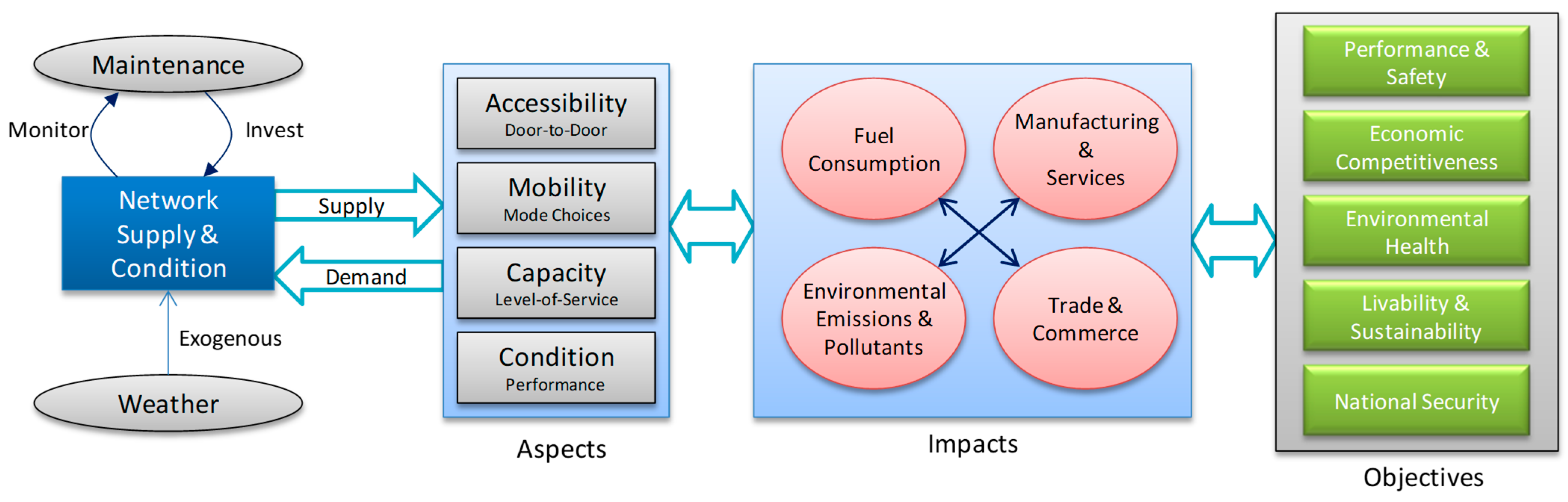
Figure 1 illustrates the author’s perspective on how characteristics of transportation relate to infrastructure supply and the broader impacts in achieving national objectives.
The figure illustrates that weather influences surface transportation condition whereas demand increases loading. While there are differences in infrastructure capabilities and utilization around the world, both loading and weather are common factors that cause deterioration, requiring discovery for remediation to maintain a stable supply. Important measures of transportation performance include accessibility, mobility, capacity, and condition, all of which depend on supply and can induce demand. These transportation aspects affect the environment, fuel consumption, manufacturing and services, and trade. Such impacts have implications to achieving national objectives such as economic competitiveness, sustainability, safety, and security. The next three subsections explore and report on the narrower recent literature covering motivations, current methods, and emerging methods of road and rail condition monitoring.
2.1. Motivations
With the expansion of the economy leading to increased traffic load density, the resulting surge in heavy vehicle traffic will intensify the strain on infrastructure, hastening its deterioration. Autonomous trucks emerged to enhance supply chain performance by reducing the impacts of driver cost and labor shortages [
4]. Such developments have the potential to induce the mode shift to trucks as both cost and transport time decrease, consequently increasing the load on pavements and bridges [
5].
Studies revealed that timely preventative maintenance extends the lifecycle of pavement [
6]. Initial studies have indicated that a successful preservation program, capable of extending the lifespan of pavement by two-fold, can lead to cost savings for states, thrice exceeding the expense of reconstruction [
7]. In a similar vein, a well-optimized track maintenance strategy can significantly lower the likelihood of train derailments [
8]. However, the efficacy of such preventative maintenance programs is inherently tied to both the volume and the caliber of the data gathered for monitoring the condition of the infrastructure.
The American Society of Civil Engineers (ASCE) has consistently given the condition rating of roads in the United States ranging from D− to D+ [
9]. Even when traffic is light, deteriorated road surfaces reduce the overall capacity, as vehicles are unable to travel safely at designated speed limits. A recent study has calculated that the cost incurred by U.S. drivers due to travelling on roads requiring repair amounts of an average of
$621 per year in additional vehicle maintenance and operation expenses [
10]. Furthermore, rough road surfaces can result in loss of vehicle control, potentially leading to accidents [
11]. The consequences extend beyond just the loss of lives, encompassing damage to freight due to excessive vibrations, revenue losses from delayed deliveries to manufacturing sites, and damages to vehicles themselves.
2.2. Current Methods
Globally, transportation agencies allocate trillions of dollars for infrastructure maintenance, traditionally prioritizing the most deteriorated areas first. However, research indicates that adopting a preservation-first strategy could cut the cost of maintaining assets by at least threefold, potentially saving hundreds of billions of dollars [
6]. This approach necessitates more regular monitoring to accurately determine the best times for maintenance.
Monitoring every segment of railroad networks is uncommon due to the high costs associated with manual and vehicle-based inspection methods [
12]. The United States federal government require Class I railroads to conduct visual inspections of most tracks at least bi-weekly to adhere to federal safety standards. Yet, as traffic increases, so does the rate of defect formation [
13], and with a trend towards reduced staffing in railroads [
14], the disparity between the occurrence of defects and the ability to detect them in time to prevent accidents, delays, and financial losses is growing.
To enhance the effectiveness of visual inspections, railroads incorporate automated inspection vehicles that help identify both emerging and established defects. This method, however, requires repair teams to schedule track access and keep pace with defect detection, dependent on weather conditions [
15]. Moreover, manual on-foot inspections remain essential as several types of defects are not detectable using vehicles. Consequently, railroad tracks become less available for commercial use during these inspection periods to ensure safety.
Agencies classified road pavement distress types caused by repeated traffic loading and temperature change into more than ten categories, including several types of cracks, potholes, plastic movement deformations, and raveling due to aggregate separation [
16]. This complexity increases the difficulty and cost of frequent monitoring using specially instrumented vehicles and extensive visual inspections. Moreover, the shortage of skilled personnel and the requirement for fast computational resources constrain the efficiency and precision of these methods. Relying on visual inspections carried out by trained professionals also poses challenges, as it tends to be laborious, variable, and sporadic in nature.
2.3. Smartphone Methods
In 2014, the Michigan Department of Transportation anticipated that in 3 to 5 years agencies can use connected vehicle data to improve transportation asset management [
17]. However, the prediction did not materialize as of 2023. Nevertheless, since then there has been a growing interest in utilizing smartphones and more recently to incorporate artificial intelligence (AI) to develop more efficient methods of road condition monitoring. Ranyal et al. (2022) reviewed the literature on AI-assisted smartphone-based road condition monitoring and found that those methods can be more accurate and faster than traditional methods [
16]. The study also emphasized the challenges of obtaining and labeling large datasets to encourage widespread utilization. In a similar review of 130 articles that focused on response-based methods, Nguyen et al. (2019) concluded that the dependence on data limits data-driven methods including machine learning techniques as compared with profile reconstruction and estimation methods [
18].
Yu et al. (2022) systematically reviewed 192 scholarly academic publications in the field and found that variations in data collection speed, vehicle type, smartphone specifications, and mounting configuration affected the accuracy and robustness of these methods [
19]. Jeong and Jo (2023) similarly concluded that in lieu of a precisely calibrated setup, the unknown mechanical characteristics of vehicles, variable driving speed, and sensor location require expensive signal processing to address those uncertainties [
3]. Yang et al. (2022) demonstrated how differences in the sensitivity of smartphone inertial sensors and their sample rate can result in measurement inconsistencies [
20]. Janani et al. (2022) further demonstrated that vehicle speed variations significantly affected the accuracy of smartphone-based measurements of ride quality [
21].
2.4. Connected Vehicles
Mahlberg et al. (2022) argued that despite the lack of standards for using connected vehicles to monitor pavement quality, agencies can begin to benefit from its potential for network level monitoring [
22]. The authors suggested that even non-connected modern vehicles have extensive instrumentation that agencies can leverage to monitor infrastructure condition including pavement markings, signs, and pavement smoothness. In a more recent investigation, Samie et al. (2023) concluded that using CVs in a crowd-sourced manner can result in a cost-effective approach to collect pavement data for evaluation [
23]. Similarly, Ruseruka et al. (2023) recently investigated the potential to leverage the built-in cameras and GPS receivers of vehicles to monitor road condition. The study found that applying You Only Look Once, Version 5 (YOLOv5) deep learning to the captured and labeled images resulted in up to 85% precision and 95% recall scores in classifying pavement distress conditions [
24].
Hijji et al. (2023) proposed a federated learning framework to exploit developments in vehicle cellular communications and Convolution Neural Networks (CNN) to detect potholes [
25]. The authors reported that the method achieved comparable performance with existing approaches, but it can be more computationally efficient to deploy. Hu et al. (2023) similarly utilized onboard cameras and an artificial Recurrent Neural Network (RNN) to detect and map slippery road conditions in real time [
26]. The authors reported that the method achieved more than 98% prediction accuracy for icy pavement.
Drones also emerged as an alternative type of connected vehicle to implement system-wide multimodal infrastructure condition monitoring. Askarzadeh et al. (2023) recently conducted an extensive systematic literature review of drone utility in railway condition monitoring [
27]. The research found that key motivations for using drones are to reduce costs, improve safety, save time, improve mobility, increase flexibility, and enhance reliability. In related work, Afsharnia and Ghavami (2023) compared smartphone-based and drone-based approaches for estimating the international roughness index (IRI), which is a standard measure of ride quality. The study found that although both methods provided comparable accuracy in IRI estimates, the smartphone method was more cost and time effective [
28]. The research reviewed makes it evident that agencies have many new opportunities to use a combination of emerging techniques to enhance performance and reduce costs. However, the lack of standards can hamper adoption.
Predictive modeling approaches that use digital twin technologies have also emerged [
29]. These methods create a virtual model of a physical object such as a road or rail section and link that model to its real-world counterpart in real-time. Sensors and other data sources collect real-time data about the physical object, which allows for continuous monitoring and predictive analysis of the object’s state. While digital twins can provide valuable insights to help improve decision-making, developing and maintaining such models for extensive road and rail networks can be expensive due to the need for massive networks of advanced sensors and their maintenance. Furthermore, digital twins rely heavily on the quality of the data collection in the field, and any breach of these data sources could potentially compromise the security of the digital twin and the physical system it represents. Although CV technology is also susceptible to cyber-breaches, an unattended and stationary sensor in the field would be more vulnerable to an attack.
In summary, extensive research exists in the domains of infrastructure condition monitoring and CV technology. While there is significant literature on the use of CVs for various applications, there is a noticeable gap in their application specifically for efficient infrastructure condition monitoring. This research addresses that gap in the literature by compiling data evidence of the need and offering implications for policymaking, industry standards, and the future of infrastructure maintenance and safety.
3. Methodology
The methodology focuses on advocating for international standardization, supported by patterns in data from transportation, economics, and patents. The analysis of transportation and economic data highlighted gaps in the current and future demand for freight movements relative to infrastructure capacity. The patent analysis identified gaps in the practical or commercial application of connected vehicles to monitor the transportation infrastructure. Subsequent subsections detail the data mining, patent mining, and the datasets utilized.
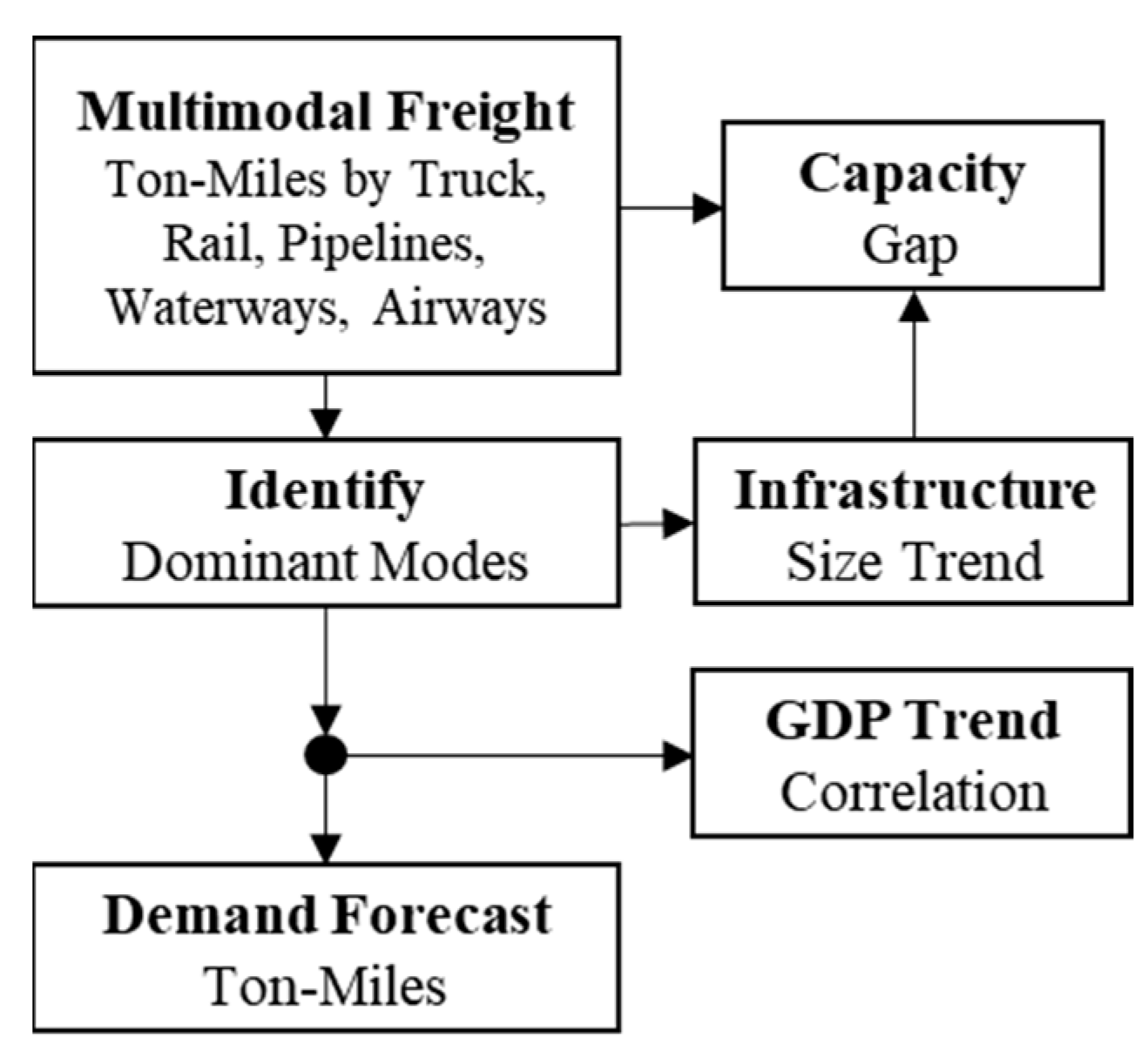
3.1. Data Mining
Four objectives guided the data analysis. First, the study ranked the importance of freight movements by the trends in the mode share. Second, it correlated the dominant freight movement trends with economic growth. Third, it emphasized the importance of preserving and maintaining the infrastructure by identifying gaps between the demand for the dominant freight movements and their infrastructure capacity. Lastly, the study estimated the future demand for infrastructure capacity by forecasting the demand for the dominant freight movements.
Figure 2 illustrates the developed data mining workflow to achieve these objectives.
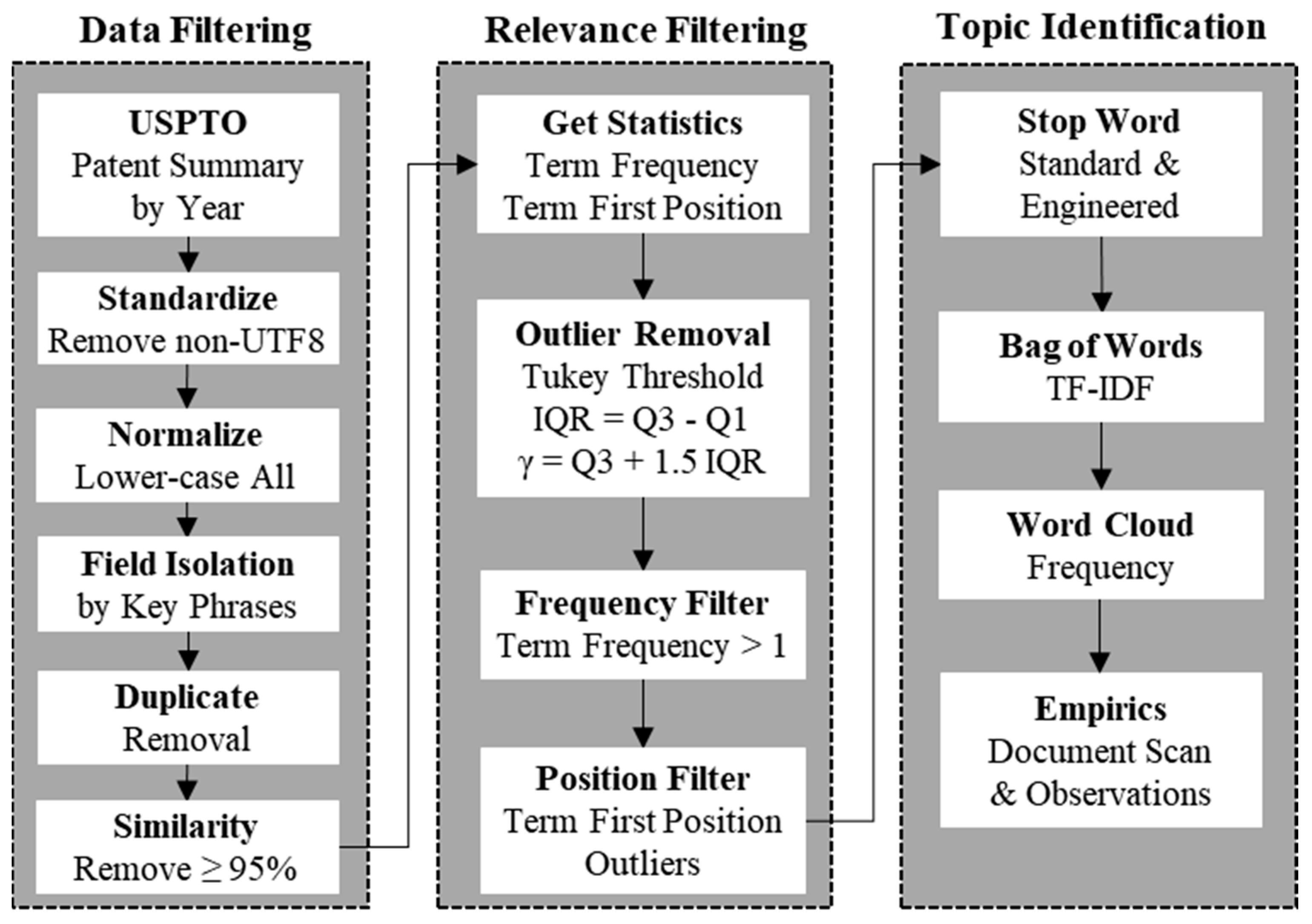
3.2. Patent Mining
Figure 3 illustrates the workflow developed to analyze trends in patenting activity related to road or rail condition monitoring using connected vehicles. Three main procedures constituted the patent analysis workflow: data filtering, relevance filtering, and topic identification. Data filtering sub-procedures cleaned the text data by removing non-standard characters (non-UTF8) that downstream procedures could not recognize. Normalizing the text by lower-casing all characters increased the accuracy of automating the search for key phrases such as “connected vehicle” and “road” or “rail” in the patent summary. Patent summaries do not include all details such as patent claims. Different patents consequently displayed similar or identical summaries, which the procedure removed.
Relevance filtering discerned and removed patent summaries that did not focus on the topic of connected vehicles. The strategy was to determine the distribution of both the frequency and first word position of a key phrase, and then remove documents that were outliers. For instance, validation confirmed that patent summaries that mentioned “connected vehicle” only once were only mildly related to the topic, so the frequency filter removed those. Similarly, patent summaries that mentioned “connected vehicle” extremely late in the description (an outlier in word position) were also only mildly related to the topic, so the position filter removed those. The Tukey threshold γ of outlier was based on the interquartile range (IQR) given by the equation shown in the figure [
30].
Topic identification relied on an empirical observation of the frequency distribution of important terms across the dataset. Term importance measured by a Term-Frequency Inverse Document Frequency (TF-IDF) score
was
The variable
is the term frequency (TF) for term
t in document
d,
is the number of patent summaries that contained term
t, and
N was the total number of patent summaries that were relevant [
31]. The ‘bag-of-words’ approach is a standard method of deriving the TF-IDF distribution for a corpus of documents. The ‘word cloud’ method is a popular means of visualizing the TF-IDF distribution for an empirical understanding of the topics covered. However, the results can be noisy or incoherent due to the presence of ‘stop’ words that are common in the English language. Standard natural language processing (NLP) libraries define stop words such as “and”, “the”, and “it” that occur frequently among individual documents. Although removing standard stop words increased the ‘signal’ in the word cloud, the remaining noise arose from words commonly used in patent description lingo. Therefore, expertise guided the selection of patent-related stop words, such as “invention”, “prior art”, “claim”, “disclosure”, “method”, “apparatus”, “patent”, “application”, and “embodiment” for removal. It was also important to remove the keywords “connected”, “vehicle”, and “vehicles” because they were common across all documents.
3.3. Datasets
Subject matter expertise guided the selection of publicly available datasets to enable the datamining and patent mining workflows defined above.
Table 1 summarizes the datasets. The road and rail length data originated from the U.S. Bureau of Transportation Statistics (BTS). The agency maintained annual road mileage data from the U.S. Department of Transportation, Federal Highway Administration (FHWA), and the Association of American Railroads (AAR). Federal legislation and policy required the States to report such data to assess the health of the highway system for the U.S. Congress and other stakeholders [
32]. The BTS also maintains multimodal freight production data by regularly collecting information from various agencies, including the FHWA, the AAR, and the U.S. Army Corps of Engineers [
33].
Data on multimodal production forecast are from the BTS based on initial data from the FHWA [
35]. The dataset includes 2.4 million records of origin-destination (OD) estimates of multimodal freight movement. Each record provided an origin zone, a destination zone, the commodity category, the weight in kilotons, the production in millions of ton-miles, the mode of transportation used, and the value in millions of dollars based on a 2017 valuation. The data incorporated forecasts of multimodal freight movements from 2017 through 2050.
The U.S. Bureau of Economic Analysis (BEA) provides a monthly update of economic statistics influencing decisions by government officials, businesses, and individuals [
37]. Key metrics of economic growth reported include personal income, personal savings, and the growth in U.S. real gross domestic products (GDP). With respect to trends in e-commerce, Statista estimated that the compound annual growth rate (CAGR) for the U.S. e-commerce market will be 11.2% from 2022 to 2027 [
36]. A series of quality checks with multiple alternative sources of the data assured its accuracy.
The U.S. Patent and Trademark Office (USPTO) maintains a comprehensive dataset of patents issued since 1776. The USPTO also maintains a large database containing summaries of the issued patents [
38]. The structure of the patent summary data was simply one column containing the patent number and another column containing the summary text. One drawback of using patent summary data lies in its exclusion of information such as the patent title, inventors, companies, and specific claims. However, utilizing patent summaries offered a lower requirement for computational capacity to process the text.
4. Results
The subsections that follow discuss the results of analyzing multimodal freight movement trends, the capacity gap analysis, forecasts for freight weight moved, and the patent analysis.
4.1. Multimodal Trends
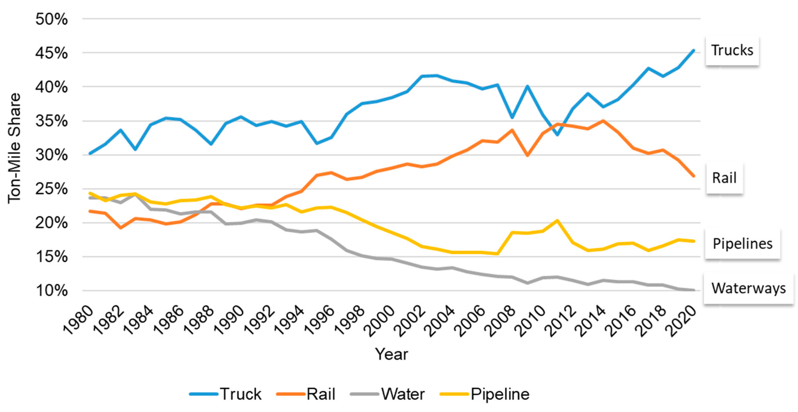
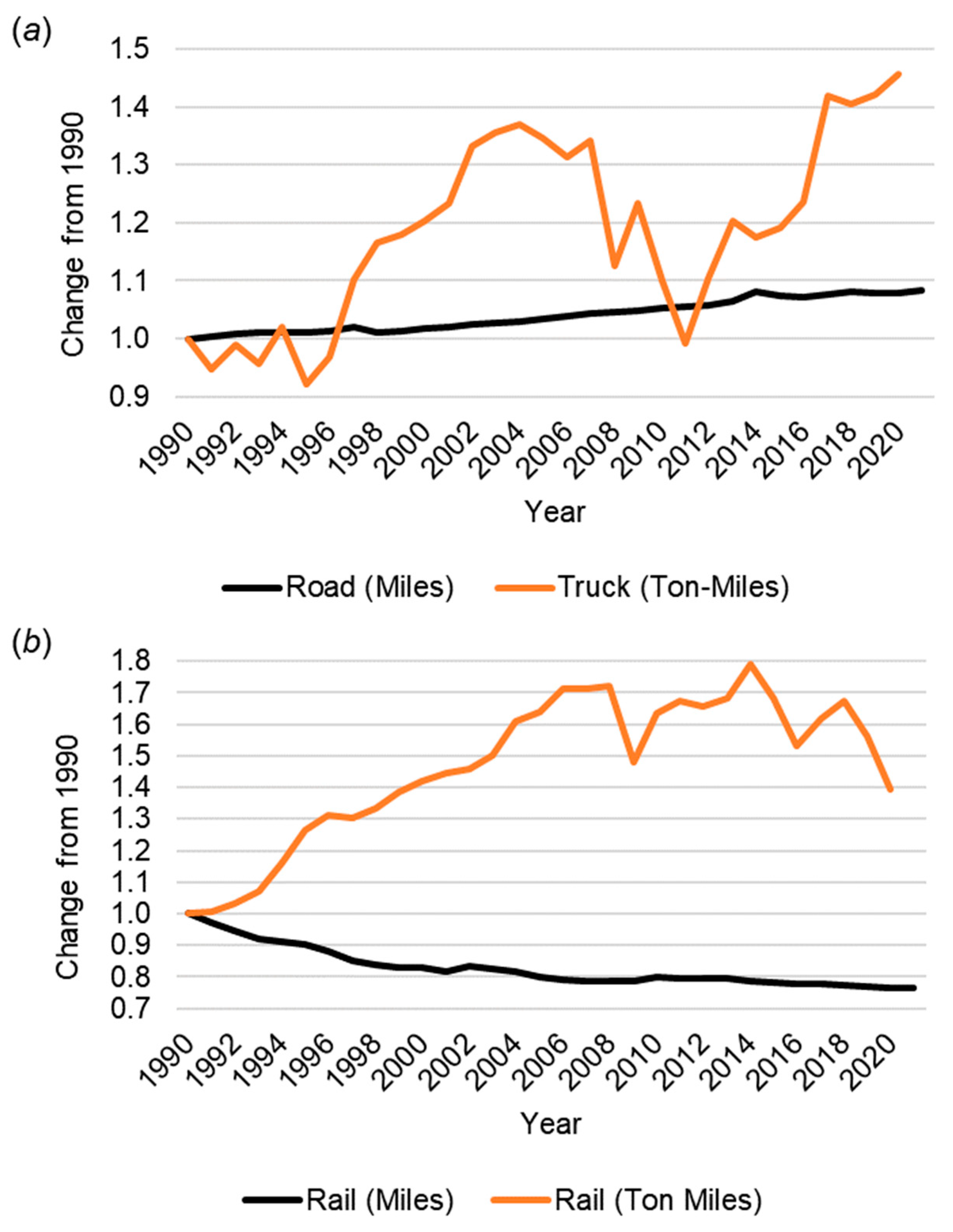
Figure 4 plots the results from data mining the multimodal freight movement data. Trucks and rail dominated with ton-mile share of 45% and 27%, respectively. The truck and rail trends have diverged since 2010. The proportion of freight moved by pipelines and waterways declined gradually after the early 1990s. The proportion of freight weight moved by air was consistently less than 1%, so the chart excludes it. These findings suggested that trucks will continue to dominate freight movements in the future.
The analysis of co-dependency between U.S. real GDP and total ton-miles yielded a correlation coefficient of 0.88. This result indicated that there was a strong positive correlation. The compound annual growth rate (CAGR) of the U.S. GDP between 1980 and 2020 was 5.1%.
One trend in
Figure 4 suggested that there had been competing mode shifts between rails and trucks since 2008 because the respective ton-mile share trends inverted. Trucks experienced a sharp increase in ton-mile share since 2011 (12.4%), whereas railroads experienced a sharp decrease (−7.6%). The trend since 2011 corresponds to an average of 2.3% increase in the U.S. GDP for nine consecutive years before declining after COVID-19. Although the trend indicates that railroads lost mode share to trucks since 2011, railroads are likely to continue leading all modes in moving the heaviest and bulkiest freight most efficiently across long distances [
39].
4.2. Capacity Gap Analysis
Figure 5 plots the results from combining the freight movement and infrastructure span data. The length of highways has increased over the 30-year-span, but only by a modest 8%. This contrasts with a 46% increase in the movement of freight by trucks over the same period. Railroads, on the other hand, decreased the length of their infrastructure by 23% over the same period, even though their production increased by 39%, peaking at 79% in 2014. This suggested that railroads have been producing more with less infrastructure.
The sharp decline for both modes around 2008 aligned with the global fiscal crisis. The sharp decline in rail production in 2020 aligns with a decline in demand during COVID-19 for bulk goods such as vehicles and construction material because people worked from home. However, trucks sustained their production during COVID-19 because of sustained demand for home deliveries and food items.
Overall, the most significant finding is that U.S. truck and rail traffic continued to outpace their infrastructure capacity. The data showed that short-term economic fluctuations do not sway trends in infrastructure development, which changes at a much slower pace. Therefore, in the absence of adequate investment to enhance capacity and maintain infrastructure, the disparity between availability and need will only continue to grow. Consequently, the growing demand to move more heavy loads will increase the extent and severity of infrastructure deterioration.
4.3. Production Forecasting
The sustained growth of e-commerce increased the demand for both truck and road capacity. Analysts forecasted the CAGR for the U.S. e-commerce market as 14.6% from 2022 to 2025 [
36]. Increasing demands for capacity will further increase congestion levels across the multi-modal surface transportation network. Additionally, as infrastructure continues to deteriorate, it leads to reduced capacity, decreased performance, and heightened risks. Therefore, maintaining road and rail infrastructure in optimal conditions becomes ever more crucial in the face of rising GDP and population growth.
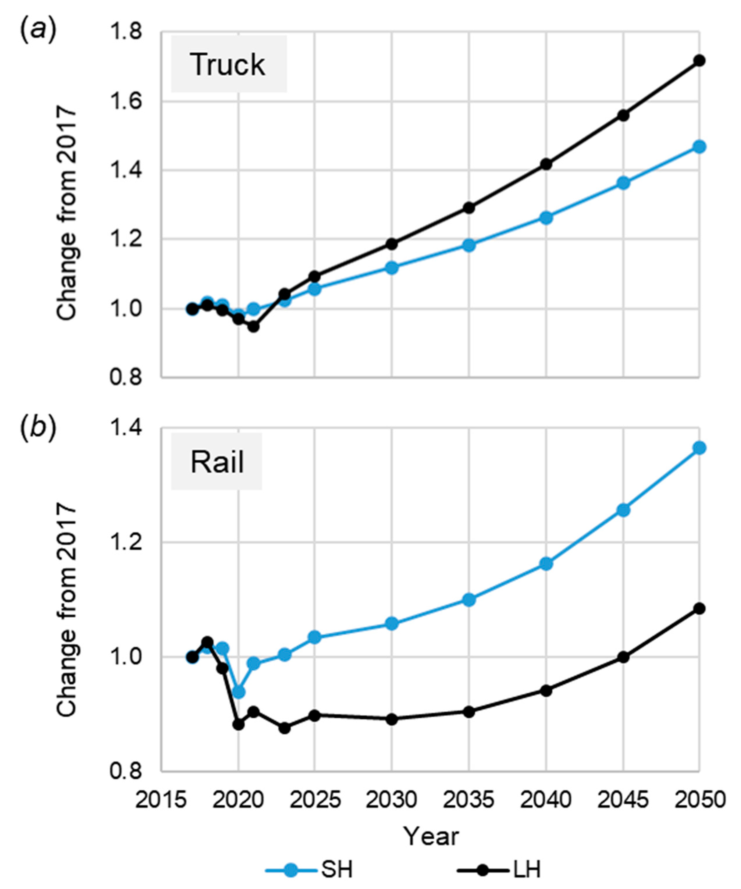
Figure 6 shows that the weight of freight moved by both truck and rail will increase steadily from 2023 to 2050. The dip in 2020 corresponds to impacts from COVID-19. The figure shows a separate forecast for short haul (SH) and long haul (LH) movements. The analysis defined LH movements as those greater than 250 miles to be consistent with the segmentation of the data into distance bands below and above that threshold.
Figure 6a shows that the weight moved by LH and SH trucks will increase by 72% and 47%, respectively, from 2017 to 2050.
Figure 6b shows that the weight moved by LH and SH rail will increase 9% and 36%, respectively, from 2017 to 2050. Interestingly, for trucks, the demand for LH will outpace SH by 2050, whereas the opposite will be true for rail. This suggested that roadway agencies needed to prioritize monitoring highways that carry LH truck traffic over shorter routes, whereas railroads should prioritize monitoring SH over LH routes. The modest increase in LH movements by rail suggests that the industry has predicted a shift from LH rail to LH trucks, perhaps spurred by an expected increase autonomous truck adoption by 2035.
4.4. Patent Analysis
The USPTO dataset contained 1,637,725 summaries of patents issued from 2018 to 2022.
Table 2 summarizes the results from the data filtering and relevance filtering procedures of the patent mining workflow presented above. On average, patents that mentioned the term “connected vehicle” or its plural form at least once accounted for less than 0.04% of the patents awarded. The relevance filtering reduced the number of patents that contained the term “connected vehicle” or “connected vehicles” by 58.5% on average. From 2018 to 2022, inventors received an average of 45 patents annually that were relevant to connected vehicles. However, the number of those patents more than tripled from 2018 to 2022, highlighting an increasing trend of innovation in the field. A surprising finding was that none of the patents described using connected vehicles to monitor road or rail infrastructure condition.
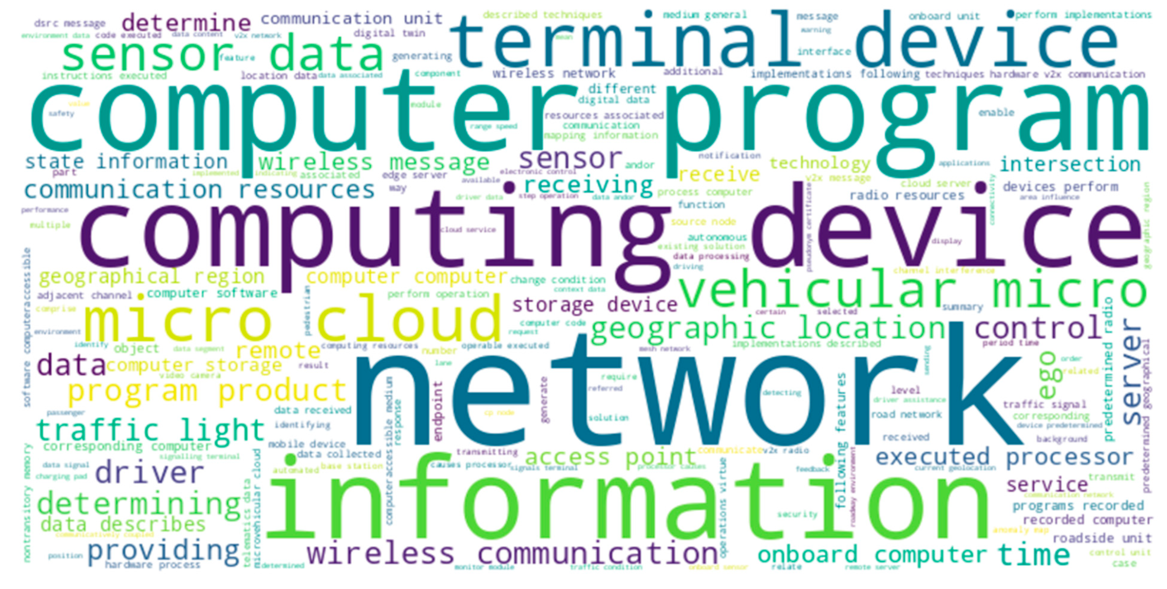
Figure 7 shows the result of the word cloud to elicit some insights into the type of problems that companies are addressing to advance the CV technology. A subsequent empirical analysis suggested that a sizable portion of those patents discussed information networks, wireless communications, computing, vehicle micro cloud development, data storage, interactions with traffic light, and sensor data about the location of moving objects like other vehicles and pedestrian. These are all topics that one would expect a patent to cover in the field of connected vehicles. The word cloud, therefore, validated the utility and accuracy of the patent data mining workflow developed.
5. Discussion
Utilizing connected vehicles to gather and transmit data on ride quality and road condition offers a more stable, long-term measure of the rate at which infrastructure deteriorates [
40]. Systems based on cloud computing can process data from integrated mobile sensors, providing precise evaluations of infrastructure conditions and their performance. On railroads, sensors fitted on trains operating in revenue service can pinpoint specific areas of track and train defects for subsequent remediation [
15]. Models analyzing the decay of infrastructure can leverage these data to determine the best times for maintenance, thus allowing both railroad and highway authorities to efficiently schedule repairs and allocate funds. This method of ongoing monitoring will naturally adapt and expand alongside increases in traffic and infrastructural growth.
The industry gained experience in using smartphones to log and upload geospatial coordinates, roughness measurements, and roadway imagery. Hence, planners can use insights from these experiences and data analysis to promote adoption. Agencies can combine road-condition monitoring data from other sources such as environmental sensor stations, wayside sensors, weigh-in-motion (WIM) systems, and remote sensing via drones and satellites [
41]. Early successes will lead more agencies to realize the benefits of using a CV approach for data acquisition. Over time, the extensive deployment of sensors and the automation of data collection will enhance the visibility and understanding of the condition of infrastructure significantly.
In review, the findings included that with a sustained GDP growth, both trucks and rail will continue to dominate freight movements and outpace the capacity of multimodal infrastructure. One interesting finding was that the demand for LH trucks will outpace SH by 2050, whereas the opposite will be true for rail. This suggested that roadway agencies can leverage the efficiency of CV technology to monitor the longest span of highways that support the heaviest load movements. These results suggest that agencies can use the data from CVs to optimize maintenance schedules and strategically allocate resources for infrastructure repair and upkeep, potentially transforming how these tasks are currently managed. Another finding was that the existing literature and practices lack a standardized methodology in this domain. A key finding was the absence of patented solutions in the field of infrastructure monitoring using connected vehicles.
One limitation of this study is that patent analysis does not necessarily indicate a lack of innovation. Several reasons exist. First, companies do not necessarily patent all inventions due to cost reasons or to protect trade secrets. Second, this study considered only U.S. issued patents, potentially missing relevant inventions filed abroad. Third, prior academic publications can discourage the filing of related patents due to fears of finding “prior art”. Lastly, patents serve as lagging indicators of technology development. Nevertheless, the lack of U.S. patents for using connected vehicles to monitor road and rail infrastructure condition reduces the barrier to standardization because there will be no need to seek a licensee to implement products based on the standard. Even so, other complications may arise that include unpublished intellectual property and proprietary technology concerns. This study paves the way for future work to expand the scope to include practical implementation strategies that could include technical, financial, and legislative challenges, including the need to address privacy, cybersecurity, cloud capacity, and network reliability issues. Even with a ratified standard, there will be variations in technology adoption across different nations, which could significantly affect the broad applicability of the CV monitoring solution.
6. Conclusions
The multimodal surface transportation infrastructure is critical to the economic competitiveness of any nation. This research motivated the use of connected vehicles (CVs) to achieve a critical advancement in road infrastructure monitoring. The study highlights the growing gap in road infrastructure capacity and the increasing demand due to economic and population growth. By leveraging CVs, road agencies can benefit from real-time data collection, enabling more efficient monitoring and maintenance of road networks. This approach is not only cost-effective but also enhances the safety and longevity of roads. The absence of patented solutions in this domain could simplify the adoption and standardization process, making it a viable solution for widespread implementation. The findings will encourage policymakers and industry stakeholders to consider this proposed approach for road infrastructure monitoring, which has the potential to revolutionize current practices.
In the realm of rail infrastructure, trains with the appropriate onboard sensors can enable continuous monitoring of the entire network. This research proposes that adopting the CV approach to rail infrastructure monitoring offers a novel solution to the traditional, costly methods. This approach can significantly enhance the capability of railroads to conduct frequent and comprehensive assessments of rail health, leading to timely maintenance and improved safety. The findings highlight the lack of existing patents in this area, indicating an open field for innovation and standardization in rail infrastructure monitoring. The implications for rail infrastructure are profound, proposing a shift towards more technologically driven, efficient, and standardized monitoring methods.
Future work will examine broader trends in connected vehicle innovations by extending the data and patent mining techniques developed in this work.


