Maximal LoRa Range for Unmanned Aerial Vehicle Fleet Service in Different Environmental Conditions
Abstract
1. Introduction
2. UAV Communication Security
- UAVs use synchronized, pseudo-random frequency hopping to prevent eavesdroppers from easily intercepting communications.
- Transmission over a wider bandwidth reduces susceptibility to interference and jamming, making signals harder to intercept
- UAVs use a predefined frequency hopping pattern, staying synchronized and hidden from unauthorized listeners
- FHSS enables multiple drones to operate in the same area with minimal interference, ideal for swarm and dense drone activity.
- FHSS can help ensure compliance with regulatory requirements for wireless communications
3. Brief Overview of LoRaWAN
4. Materials and Methods
4.1. Hardware Specifications
4.2. Geographical Areas
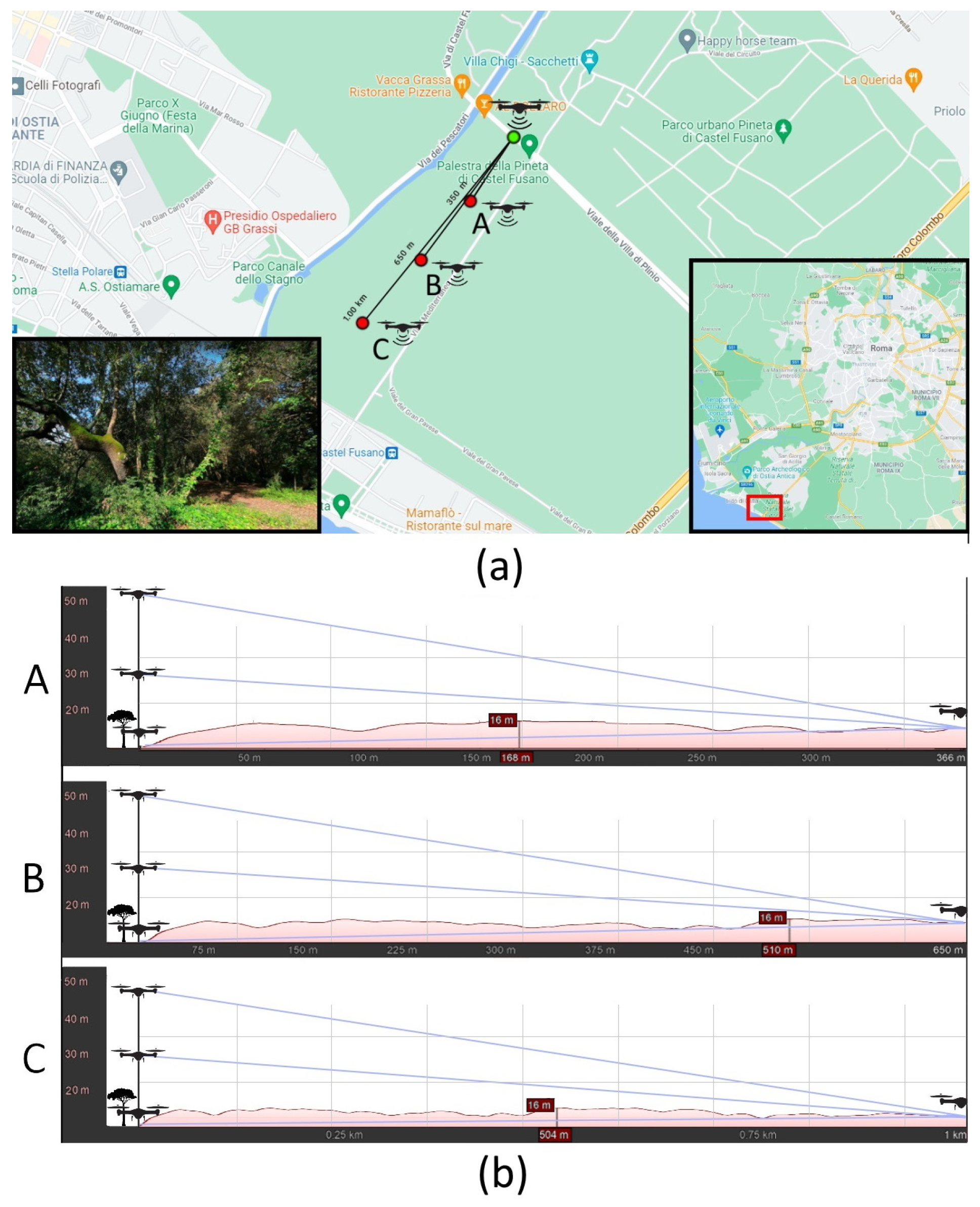
- Dense vegetation: Dense vegetation characterizes the Castel Porziano Reserve’ an area, spanning approximately 60 km2, which is close to Rome and not entirely accessible. The specific area of interest highlighted in Figure 3 covers about km2 and is notable for its dense coverage of medium to tall trees. The vegetation within the designated test area is dense and poses both challenges and opportunities for testing purposes, particularly in evaluating the system’s communication efficiency and sensor capabilities in environments with significant natural obstacles. Conducting tests in such environments provides valuable insights into how well the system performs under real-world conditions where dense vegetation can affect signal propagation and data collection by sensors. These tests are crucial for assessing the system’s adaptability and robustness in diverse environmental settings, ensuring its effectiveness in applications such as environmental monitoring, wildlife conservation, and ecosystem management within protected areas like the Castel Porziano Reserve.
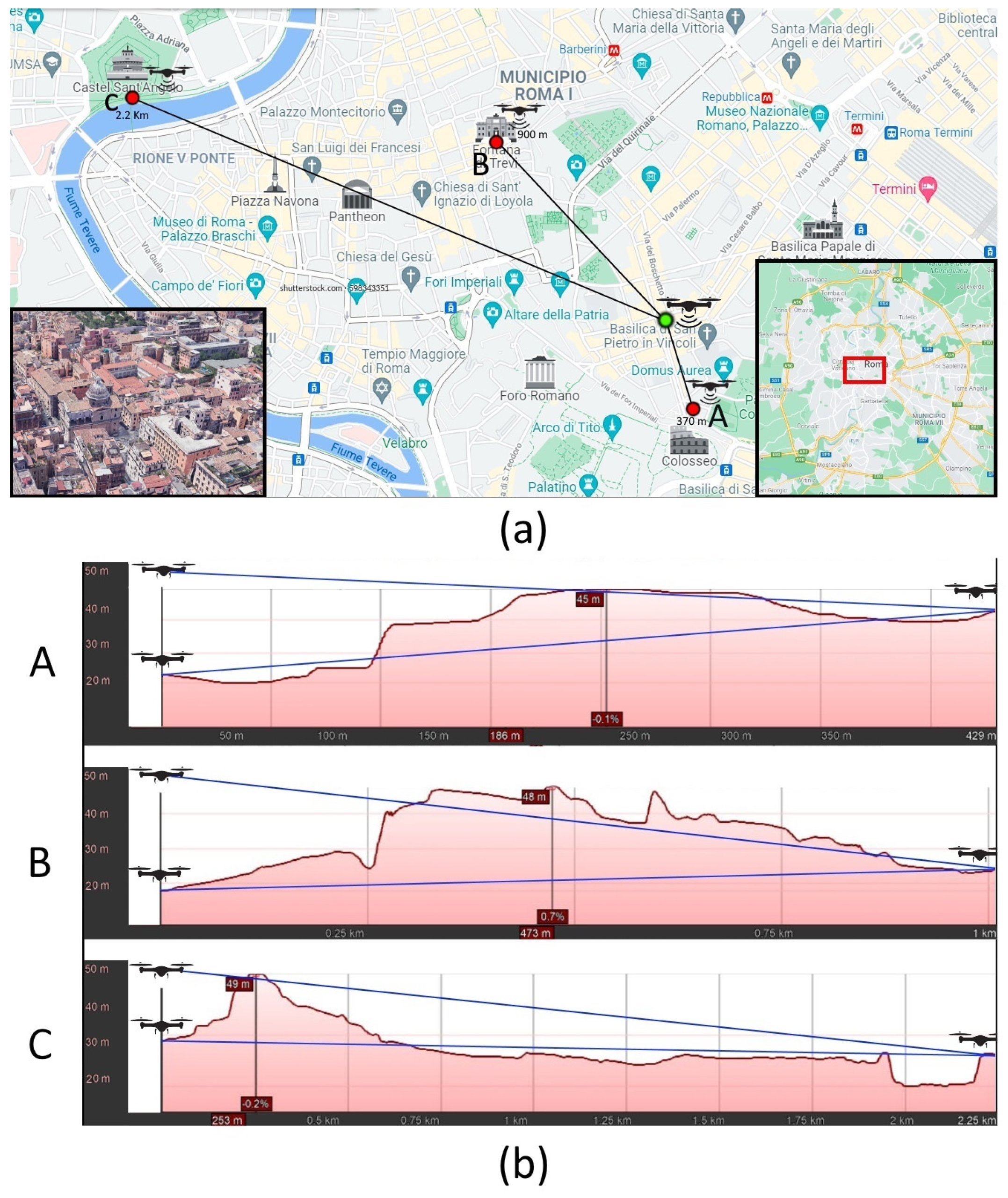
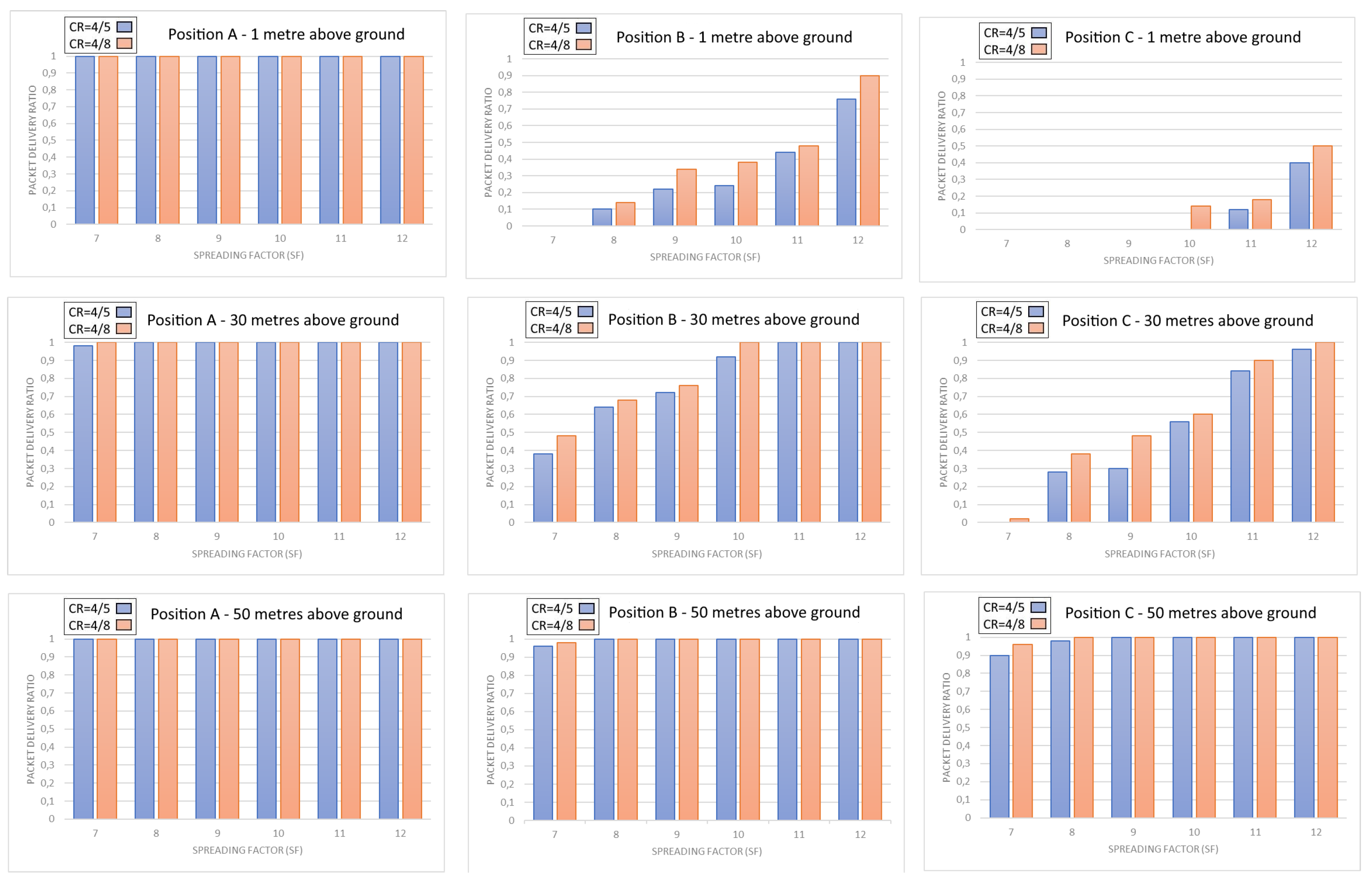
- Urban area. Figure 4 provides a visual representation of the spatial distribution of three drone radio modules positioned strategically within the historical center of Rome. These locations were chosen near Castel Sant’Angelo, the Trevi Fountain, and the Colosseum, highlighting the system’s deployment in densely populated urban settings. Due to flight restrictions within the historical center, the drone operated along a strictly vertical trajectory, remaining within the confines of the departure location’s property perimeter. To ensure privacy compliance, all onboard cameras were deactivated during flight operations. Testing in urban environments presented substantial challenges for establishing reliable communication links, even when operating at an altitude of 50 m. The gathered data revealed significant hurdles stemming from both man-made structures and the natural topography of Rome’s historic center. The city’s undulating terrain, characterized by hills and valleys, posed a barrier to signal propagation, complicating the efforts required to maintain consistent communication between the drone and ground stations. Moreover, the presence of dense buildings further exacerbated signal attenuation and interference. These urban conditions underscored the importance of adaptive communication protocols and robust signal processing techniques to overcome obstacles and ensure uninterrupted data transmission. Despite these challenges, conducting tests in urban environments allowed us to evaluate adaptive strategies to optimize communication reliability and efficiency in complex urban landscapes. Such testing is crucial for enhancing the system’s resilience and adaptability, ensuring its effectiveness in urban applications such as emergency response, infrastructure monitoring, and cultural heritage preservation, where reliable communication and data transmission are paramount.
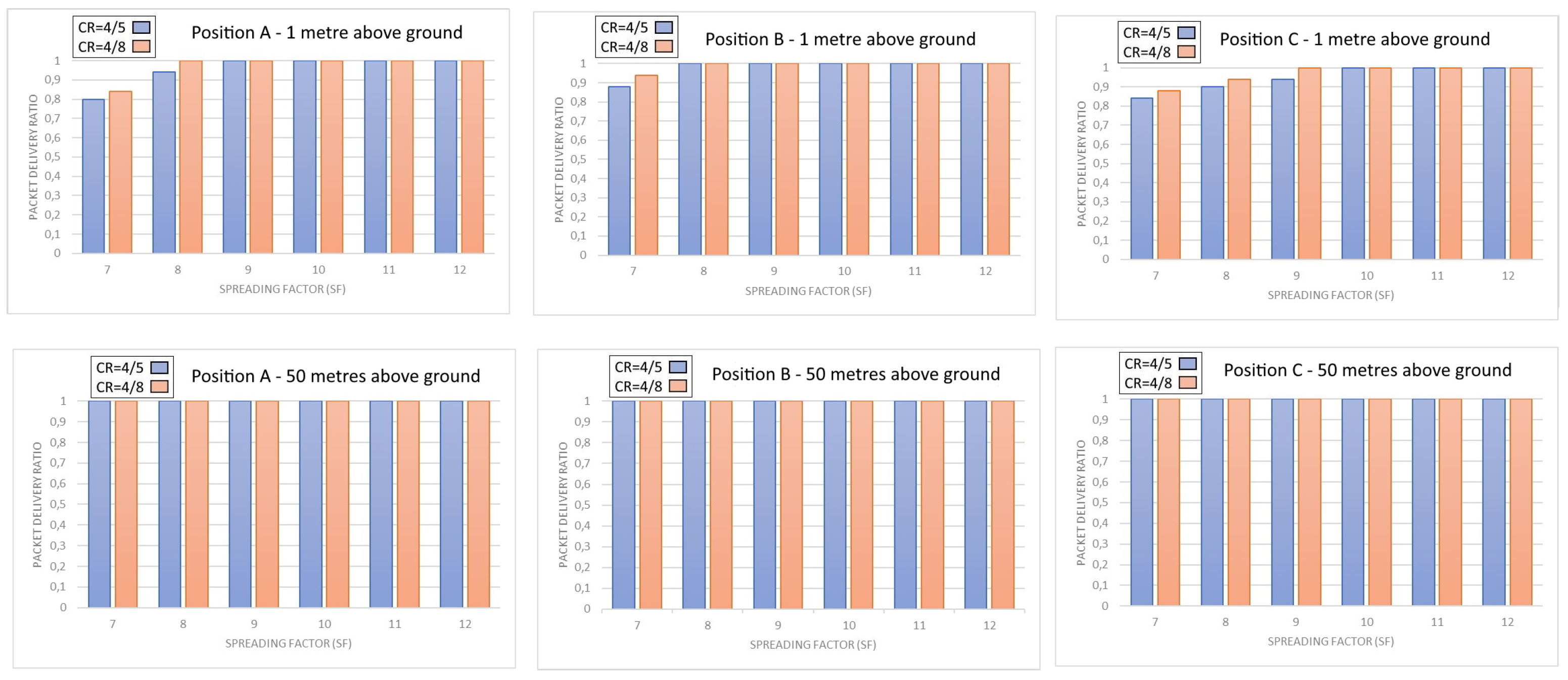
- Agricultural area: Figure 5 depicts the strategic positioning of both the gateway and drone radio modules within an agricultural area. This area is primarily devoted to the cultivation of wheat and maize, characterized by wide-open spaces that are devoid of obstructive elements that might interfere with signal transmission. The placement of three survey points along a designated bicycle path, along with the strategically located gateway, was carefully planned to maximize coverage and data collection efficiency. The topography of the surveyed locations is flat, contributing to optimal conditions for signal propagation. Additionally, the vegetation density is small, and natural obstacles are typically under 50 cm in height throughout the entire designated area. This ensures minimal attenuation of signals, thereby facilitating robust communication between the drone radio modules and ground-based equipment. The testing in this environment offers distinct advantages for assessing the system’s performance in rural and crop cultivation settings. The absence of tall structures and the uniform terrain simplify signal management and data transmission processes, highlighting the system’s adaptability and reliability under favorable environmental conditions. These tests provide valuable insights into optimizing communication protocols and sensor deployment strategies tailored to agricultural monitoring and management applications.
4.3. Experimental Procedures and Parameters
5. Maximal Coverage Condition Analysis
5.1. Dense Vegetation
5.2. Urban Area
5.3. Agricultural Area
6. Conclusions
- Urban. There is evidence of a less-linear and more-sudden improvement when increasing the height of the gateway due to the presence of buildings and wall structures, and in general, there is greater inhomogeneity in the structure of the obstacles. The possibility of reducing the length of the payload allows for improved communication capabilites.
- Agricultural: The extreme uniformity and absence of both natural and artificial obstacles that make up a vast agricultural environment were reflected in the almost uniformity of the measurements taken both at ground level and at a height of 50 m.
- Woodland: There is evidence of an almost linear improvement of the signal quality as the height of the gateway increases due to the extreme homogeneity of the obstacles constituted by tall trees.
Author Contributions
Funding
Data Availability Statement
Conflicts of Interest
References
- Utsav, A.; Abhishek, A.; Suraj, P.; Badhai, R.K. An IoT based UAV network for military applications. In Proceedings of the 2021 Sixth International Conference on Wireless Communications, Signal Processing and Networking (WiSPNET), Chennai, India, 25–27 March 2021; pp. 122–125. [Google Scholar]
- Zhu, X. Analysis of military application of UAV swarm technology. In Proceedings of the 2020 3rd International Conference on Unmanned Systems (ICUS), Harbin, China, 27–28 November 2020; pp. 1200–1204. [Google Scholar]
- Martinez-Alpiste, I.; Golcarenarenji, G.; Wang, Q.; Alcaraz-Calero, J.M. Search and rescue operation using UAVs: A case study. Expert Syst. Appl. 2021, 178, 114937. [Google Scholar] [CrossRef]
- Viguria, A.; Maza, I.; Ollero, A. Distributed service-based cooperation in aerial/ground robot teams applied to fire detection and extinguishing missions. Adv. Robot. 2010, 24, 1–23. [Google Scholar] [CrossRef]
- Gu, X.; Zhang, G. A survey on UAV-assisted wireless communications: Recent advances and future trends. Comput. Commun. 2023, 208, 44–78. [Google Scholar] [CrossRef]
- Al-lQubaydhi, N.; Alenezi, A.; Alanazi, T.; Senyor, A.; Alanezi, N.; Alotaibi, B.; Alotaibi, M.; Razaque, A.; Hariri, S. Deep learning for unmanned aerial vehicles detection: A review. Comput. Sci. Rev. 2024, 51, 100614. [Google Scholar] [CrossRef]
- Chen, C.; Zheng, Z.; Xu, T.; Guo, S.; Feng, S.; Yao, W.; Lan, Y. Yolo-Based UAV Technology: A Review of the Research and Its Applications. Drones 2023, 7, 190. [Google Scholar] [CrossRef]
- Jouhari, M.; Saeed, N.; Alouini, M.-S.; Amhoud, E.M. A Survey on Scalable LoRaWAN for Massive IoT: Recent Advances, Potentials, and Challenges. IEEE Commun. Surv. Tutorials 2023, 25, 1841–1876. [Google Scholar] [CrossRef]
- Giuliano, R.; Innocenti, E.; Mazzenga, F.; Vegni, A.M.; Vizzarri, A. IMPERSONAL: An IoT-Aided Computer Vision Framework for Social Distancing for Health Safety. IEEE Internet Things J. 2022, 9, 7261–7272. [Google Scholar] [CrossRef]
- Mozaffari, M.; Lin, X.; Hayes, S. Toward 6G with Connected Sky: UAVs and Beyond. IEEE Commun. Mag. 2021, 59, 74–80. [Google Scholar] [CrossRef]
- Khalifeh, A.; Aldahdouh, K.A.; Darabkh, K.A.; Al-Sit, W. A Survey of 5G Emerging Wireless Technologies Featuring LoRaWAN, Sigfox, NB-IoT and LTE-M. In Proceedings of the 2019 International Conference on Wireless Communications Signal Processing and Networking (WiSPNET), Chennai, India, 21–23 March 2019; pp. 561–566. [Google Scholar]
- Bianco, G.M.; Giuliano, R.; Mazzenga, F.; Marrocco, G. Multi-Slope Path Loss and Position Estimation With Grid Search and Experimental Results. IEEE Trans. Signal Inf. Process. Over Netw. 2021, 7, 551–561. [Google Scholar] [CrossRef]
- Lagkas, T.; Argyriou, V.; Bibi, S.; Sarigiannidis, P. UAV IoT framework views and challenges: Towards protecting drones as “Things”. Sensors 2018, 18, 4015. [Google Scholar] [CrossRef] [PubMed]
- Eun, J.; Song, B.D.; Lee, S.; Lim, D.E. Mathematical investigation on the sustainability of UAV logistics. Sustainability 2019, 11, 5932. [Google Scholar] [CrossRef]
- Cordova, F.; Olivares, V. Design of drone fleet management model in a production system of customized products. In Proceedings of the 2016 6th International Conference on Computers Communications and Control (ICCCC), Oradea, Romania, 10–14 May 2016; pp. 165–172. [Google Scholar]
- Shakhatreh, H.; Sawalmeh, A.H.; Al-Fuqaha, A.; Dou, Z.; Almaita, E.; Khalil, I.; Othman, N.S.; Khreishah, A.; Guizani, M. Unmanned aerial vehicles (UAVs): A survey on civil applications and key research challenges. IEEE Access 2019, 7, 48572–48634. [Google Scholar] [CrossRef]
- Thibbotuwawa, A.; Nielsen, P.; Zbigniew, B.; Bocewicz, G. Energy consumption in unmanned aerial vehicles: A review of energy consumption models and their relation to the UAV routing. In Information Systems Architecture and Technology: Proceedings of 39th International Conference on Information Systems Architecture and Technology–ISAT 2018: Part II; Springer International Publishing: Berlin/Heidelberg, Germany, 2019; pp. 173–184. [Google Scholar]
- Boukoberine, M.N.; Zhou, Z.; Benbouzid, M. A critical review on unmanned aerial vehicles power supply and energy management: Solutions, strategies, and prospects. Appl. Energy 2019, 255, 113823. [Google Scholar] [CrossRef]
- Debnath, S.K.; Omar, R.; Latip, N.B.A. A review on energy efficient path planning algorithms for unmanned air vehicles. In Proceedings of the Computational Science and Technology: 5th ICCST 2018, Kota Kinabalu, Malaysia, 29–30 August 2018; pp. 523–532. [Google Scholar]
- Xiong, F.; Zheng, H.; Ruan, L.; Wang, H.; Tang, L.; Dong, X.; Li, A. Energy-saving data aggregation for multi-UAV system. IEEE Trans. Veh. Technol. 2020, 69, 9002–9016. [Google Scholar] [CrossRef]
- Jin, Y.; Minai, A.A.; Polycarpou, M.M. Cooperative real-time search and task allocation in UAV teams. In Proceedings of the 42nd IEEE International Conference on Decision and Control (IEEE Cat. No. 03CH37475), Maui, HI, USA, 9–12 December 2003; Volume 1, pp. 7–12. [Google Scholar]
- Barka, E.; Kerrache, C.A.; Benkraouda, H.; Shuaib, K.; Ahmad, F.; Kurugollu, F. Towards a trusted unmanned aerial system using blockchain for the protection of critical infrastructure. Trans. Emerg. Telecommun. Technol. 2022, 33, e3706. [Google Scholar] [CrossRef]
- Simon, M.; Omura, J.; Scholtz, R.; Levitt, B. Spread Spectrum Communications Handbook; McGraw-Hill: New York, NY, USA, 1994. [Google Scholar]
- Strasser, M.; Capkun, S.; Popper, C.; Cagalj, M. Jamming-resistant key establishment using uncoordinated frequency hopping. In Proceedings of the IEEE Symposium on Security and Privacy (May 2008), Oakland, CA, USA, 18–22 May 2008; pp. 64–78. [Google Scholar]
- Silva, F.S.; Neto, E.P.; Oliveira, H.; Rosário, D.; Cerqueira, E.; Both, C.; Zeadally, S.; Neto, A.V. A Survey on Long-Range Wide-Area Network Technology Optimizations. IEEE Access 2021, 9, 106079–106106. [Google Scholar] [CrossRef]
- Mao, Y.; You, C.; Zhang, J.; Huang, K.; Letaief, K.B. A Survey on Mobile Edge Computing: The Communication Perspective. IEEE Commun. Surv. Tutor. 2017, 19, 2322–2358. [Google Scholar] [CrossRef]
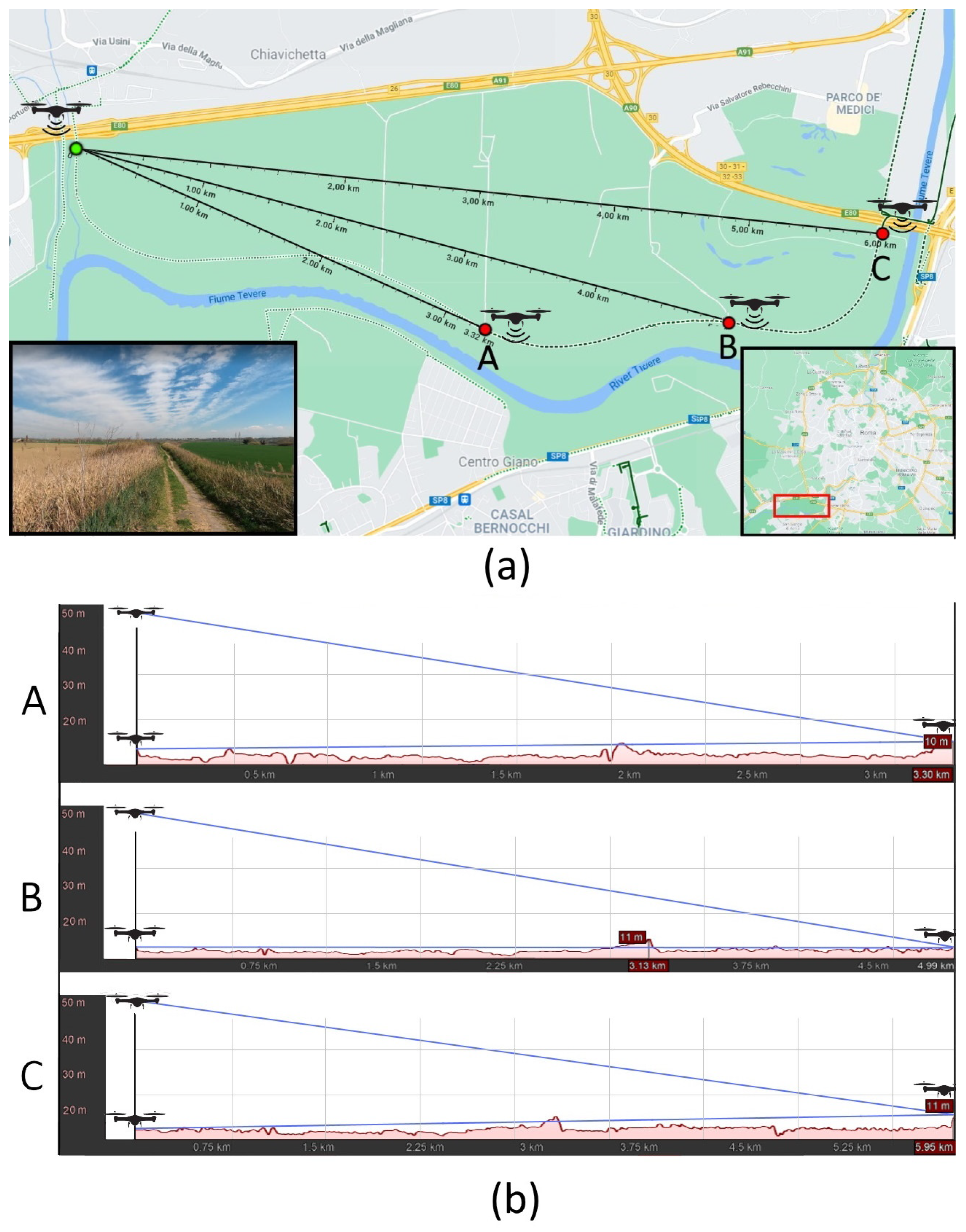

| Dense Vegetation | Urban Area | Agricultural Area | |
|---|---|---|---|
| Position | dist [m] | dist [m] | dist [m] |
| A | 350 | 430 | 3320 |
| B | 650 | 1000 | 5000 |
| C | 1000 | 2250 | 6000 |
| POS A | POS B | POS C | |
|---|---|---|---|
| Payload [bytes] | PDR | PDR | PDR |
| 20 | 1 | 1 | 1 |
| 25 | 1 | 1 | 1 |
| 30 | 1 | 1 | 1 |
| 35 | 1 | 1 | 1 |
| 40 | 1 | 1 | 1 |
| POS A | POS B | POS C | |
|---|---|---|---|
| Payload [bytes] | PDR | PDR | PDR |
| 20 | 1 | 1 | 0.95 |
| 25 | 1 | 1 | 0.9 |
| 30 | 1 | 1 | 0.8 |
| 35 | 1 | 0.95 | 0.65 |
| 40 | 1 | 0.85 | 0.45 |
| POS A | POS B | POS C | |
|---|---|---|---|
| Payload [bytes] | PDR | PDR | PDR |
| 20 | 1 | 1 | 0.45 |
| 25 | 1 | 0.75 | 0.4 |
| 30 | 1 | 0.5 | 0.35 |
| 35 | 0.9 | 0.45 | 0.25 |
| 40 | 0.85 | 0.45 | 0.2 |
| POS A | POS B | POS C | |
|---|---|---|---|
| Payload [bytes] | PDR | PDR | PDR |
| 20 | 1 | 1 | 1 |
| 25 | 1 | 1 | 1 |
| 30 | 1 | 1 | 1 |
| 35 | 1 | 1 | 1 |
| 40 | 1 | 1 | 1 |
Disclaimer/Publisher’s Note: The statements, opinions and data contained in all publications are solely those of the individual author(s) and contributor(s) and not of MDPI and/or the editor(s). MDPI and/or the editor(s) disclaim responsibility for any injury to people or property resulting from any ideas, methods, instructions or products referred to in the content. |
© 2024 by the authors. Licensee MDPI, Basel, Switzerland. This article is an open access article distributed under the terms and conditions of the Creative Commons Attribution (CC BY) license (https://creativecommons.org/licenses/by/4.0/).
Share and Cite
Felli, L.; Giuliano, R.; De Negri, A.; Terlizzi, F.; Mazzenga, F.; Vizzarri, A. Maximal LoRa Range for Unmanned Aerial Vehicle Fleet Service in Different Environmental Conditions. IoT 2024, 5, 509-523. https://doi.org/10.3390/iot5030023
Felli L, Giuliano R, De Negri A, Terlizzi F, Mazzenga F, Vizzarri A. Maximal LoRa Range for Unmanned Aerial Vehicle Fleet Service in Different Environmental Conditions. IoT. 2024; 5(3):509-523. https://doi.org/10.3390/iot5030023
Chicago/Turabian StyleFelli, Lorenzo, Romeo Giuliano, Andrea De Negri, Francesco Terlizzi, Franco Mazzenga, and Alessandro Vizzarri. 2024. "Maximal LoRa Range for Unmanned Aerial Vehicle Fleet Service in Different Environmental Conditions" IoT 5, no. 3: 509-523. https://doi.org/10.3390/iot5030023
APA StyleFelli, L., Giuliano, R., De Negri, A., Terlizzi, F., Mazzenga, F., & Vizzarri, A. (2024). Maximal LoRa Range for Unmanned Aerial Vehicle Fleet Service in Different Environmental Conditions. IoT, 5(3), 509-523. https://doi.org/10.3390/iot5030023


