Seismicity Patterns in Some Mediterranean Zones After the 1939 Anatolian Earthquake: Insights on Seismic Risk and the Tectonic Setting

 ,
,
Abstract
1. Introduction
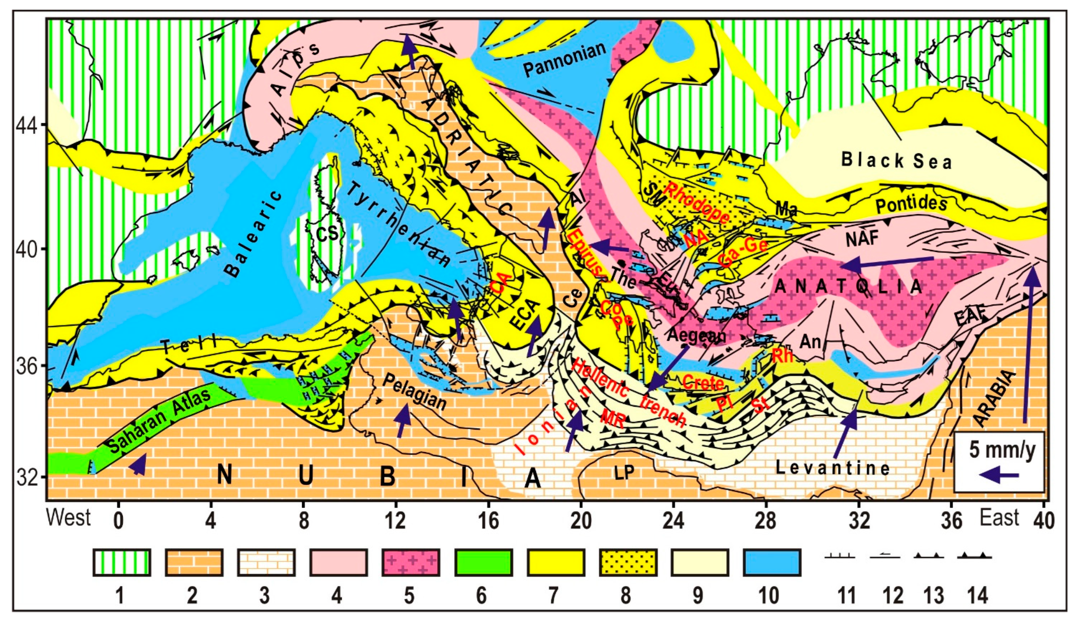
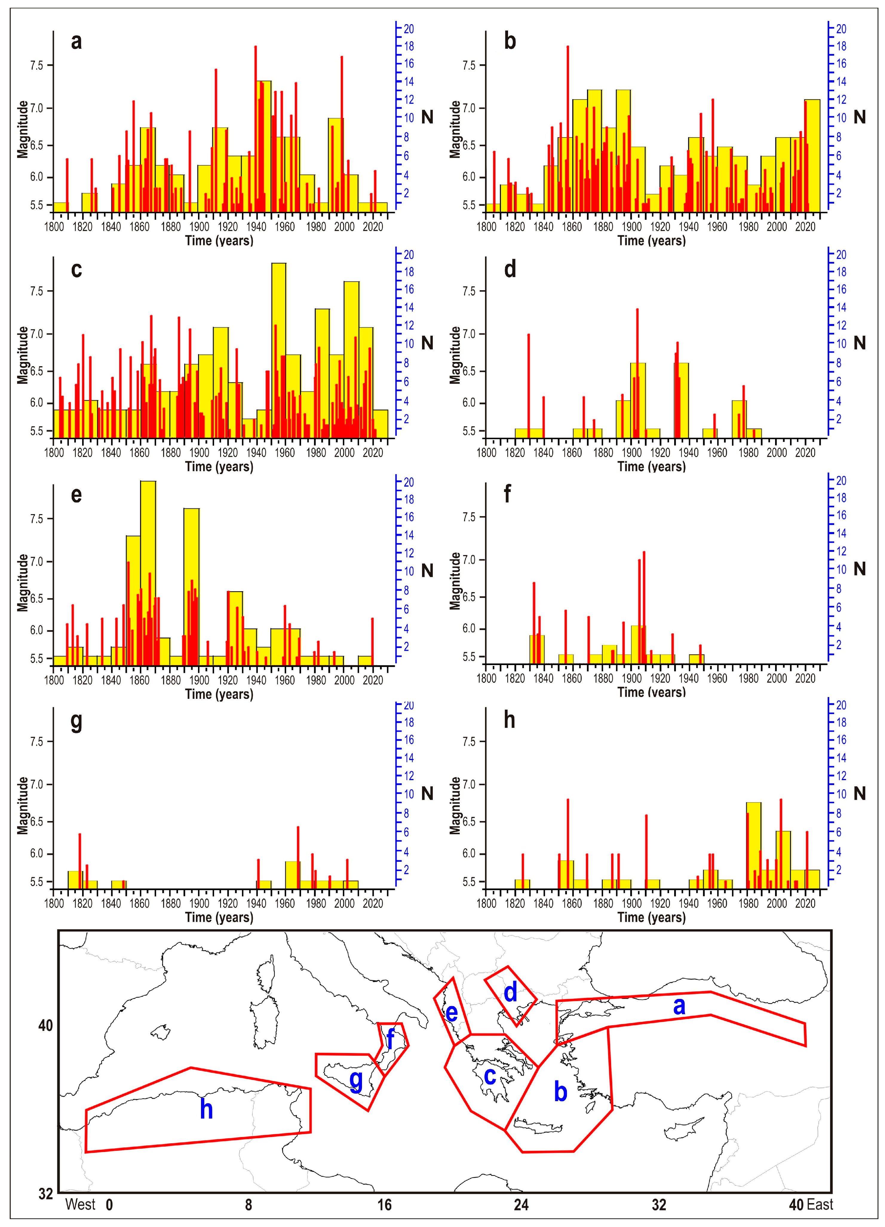
2. Seismicity Time Patterns (1800–2024) and Underlying Tectonic Mechanisms
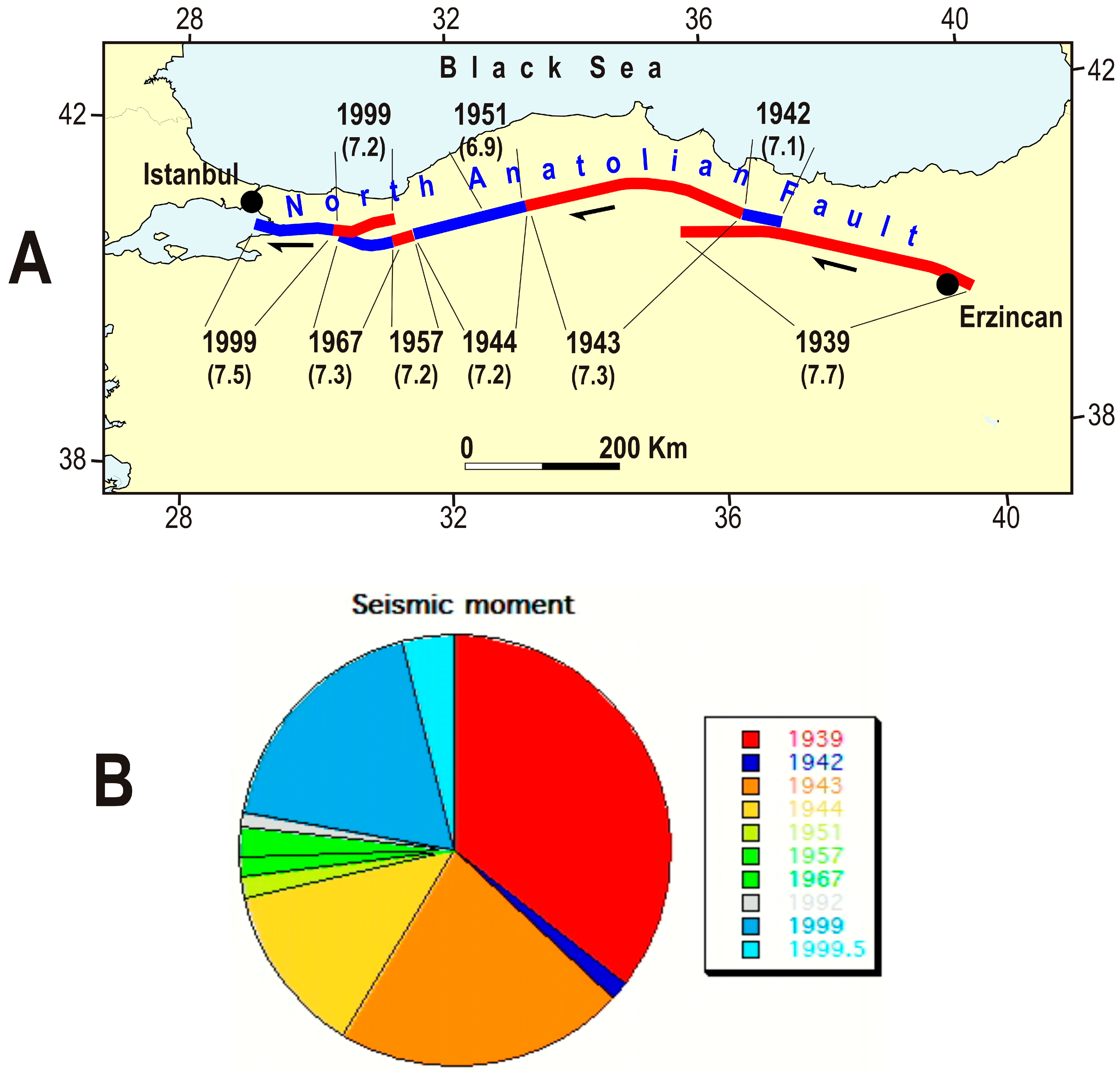
2.1. North Anatolian Fault
2.2. Western Anatolia and Crete–Rhodes Arc
2.3. Southern Greece (Peloponnesus, Cephalonia Fault, Corinth, Ambracique, Eubea, and Thessaly Troughs)
2.4. Serbo-Macedonian Fault System (SM)
2.5. Outer Northern Hellenides (Epirus) and Albanides
2.6. Calabrian Wedge
2.7. Sicily
2.8. Tell System
3. Discussion
4. Conclusions
- After the considerable stress drops that occurred in the North Anatolian Fault (NAF) during previous decades, one might assume that the shear stress along this discontinuity has significantly decreased, potentially implying a moderate risk of major events. However, this tentative prediction may not apply to the easternmost sector of the NAF, as the two strong earthquakes that struck the Eastern Anatolian Fault in 2023 (M = 7.8, 7.6) may have facilitated a westward displacement of the easternmost Anatolian wedge, thereby increasing shear stress along the easternmost segment of the NAF. Nevertheless, it is unlikely that such an increase could fully reload the fault near the rupture point, given the significant drop in stress in 1939. We believe that a geodetic analysis of the strain field evolution in these areas can be useful.
- The progressive decrease in seismic activity following the intense seismic phase between 1948 and 1960 (Figure 3, Table 2) could indicate that the effects of the major Anatolian displacement in the western margin of Anatolia have passed their most intense phase. However, the emergence of a new seismic phase around 2013, which includes nine earthquakes with M ≥ 6, may suggest that this fault system is experiencing a stress increase, possibly triggered by the two strong earthquakes that occurred in 1999 along the westernmost NAF (Marmara Sea region, M = 7.5, 7.2). The recent seismic activity in the Santorini region and its potential developments could be part of this ongoing seismic phase.
- One could expect that the two strong earthquakes that in 1999 hit the westernmost sector of the NAF have also triggered an increase in shear stress in the North Aegean Faults located along the two-branches westward of the NAF. This hypothesis is compatible with the occurrence of a major shock (M = 6.9) in 2014 along the above zone.
- The compressional effects induced by the post-1939 Anatolian jump (documented by geodetic data) and the seismic quiescence in the Epirus zone since 1940 suggest a low hazard in the normal faults of the Serbo-Macedonian zone, as argued earlier.
- The seismic history of southern Greece shows almost continuous activity in the last two centuries. This evidence, corroborated by the fact that three major shocks have recently occurred in Cephalonia fault in 2018, M = 6.8, and in the Thessaly troughs in 2021, M = 6.3 and 6.2, does not allow us to exclude the occurrence of a major shock in the next decade.
- In the Epirus–Albanides zone, the lack of major earthquakes during a relatively long period (1963–2002) might be an effect of the deformation that the southern Adria plate is undergoing in response to the westward push of the Anatolian–Aegean system. However, the occurrence of some significant shocks in the last 20 years (2003 M = 6.4, 2015 M = 6.5, and 2019 M = 6.2) could indicate the progressive mitigation of the above effect, with a consequent progressive increase in seismic hazard.
- In Calabria, the complete absence of events with M > 5.5 since 1947 may lead us to suppose that the present seismic hazard is not high. However, it is not easy to recognize how long this situation can go on for. The analysis of geodetic data may help to recognize eventual changes in the velocity field, possibly induced by the attenuation of the effects of the post-1939 Anatolian jump.
- The fact that geodetic data indicates a roughly NW-ward motion of the northern Nubian belt (in contrast to the NNE-ward trend inferred from the Plio–Quaternary deformation pattern [1,26,27]) suggests that this zone is still experiencing the effects of the Anatolian jump and that consequently the occurrence of major shocks in the next decade can hardly be excluded.
Author Contributions
Funding
Data Availability Statement
Conflicts of Interest
References
- Mantovani, E.; Viti, M.; Babbucci, D.; Tamburelli, C. Neogenic Evolution of the Mediterranean Region: Geodynamics, Tectonics and Seismicity; Springer Nature: Cham, Switzerland, 2024; p. 174. ISBN 3031621492/9783031621499. [Google Scholar]
- Anderson, D.L. Accelerated plate tectonics. Science 1975, 167, 1077–1079. [Google Scholar] [CrossRef]
- Mantovani, E.; Viti, M.; Cenni, N.; Albarello, D.; Babbucci, D. Short and long-term deformation patterns in the Aegean-Anatolian systems: Insights from space geodetic data (GPS). Geophys. Res. Lett. 2001, 28, 2325–2328. [Google Scholar] [CrossRef]
- Cenni, N.; D’onza, F.; Viti, M.; Mantovani, E.; Albarello, D.; Babbucci, D. Post seismic relaxation processes in the Aegean-Anatolian system: Insights from space geodetic data (GPS) and geological/geophysical evidence. Boll. Geofis. Teor. Appl. 2002, 43, 23–36. [Google Scholar]
- Kenner, S.; Segall, P. Lower Crustal Structure in Northern California: Implications From Strain-Rate Variations Following the 1906 San Francisco Earthquake. J. Geophys. Res. 2003, 108, ETG 5-1–ETG 5-17. [Google Scholar] [CrossRef]
- Freed, A.M.; Bürgmann, R. Evidence of power-law flow in the Mojave Desert mantle. Nature 2004, 430, 548–551. [Google Scholar] [CrossRef] [PubMed]
- Freed, A.M. Earthquake triggering by static, dynamic, and postseismic stress transfer. Annu. Rev. Earth Planet. Sci. 2005, 33, 335–367. [Google Scholar] [CrossRef]
- Sunbul, F.; Nalbant, S.S.; Simão, N.M.; Steacy, S. Investigating viscoelastic postseismic deformation due to large earthquakes in East Anatolia, Turkey. J. Geodyn. 2016, 94–95, 50–58. [Google Scholar] [CrossRef]
- Barka, A.A. Slip distribution along the North Atlantic fault associated with the large earthquakes of the period 1939 to 1967. Bull. Seismol. Soc. Am. 1996, 86, 1238–1254. [Google Scholar] [CrossRef]
- Stein, R.S.; Barka, A.A.; Dieterich, J.H. Progressive failure on the North Anatolian fault since 1939 by earthquake stress triggering. Geophys. J. Int. 1997, 128, 594–604. [Google Scholar] [CrossRef]
- Şengör, A.M.C.; Tüysüz, O.; İmren, C.; Sakınç, M.; Eyidoğan, H.; Görü, N.; Le Pichon, X.; Rangin, C. The North Anatolian Fault. A new look. Annu. Rev. Earth Planet. Sci. 2005, 33, 37–112. [Google Scholar] [CrossRef]
- Di Giacomo, D.; Bondár, I.; Storchak, D.A.; Engdahl, E.R.; Bormann, P.; Harris, J. ISCGEM:Global Instrumental Earthquake Catalogue (1900–2009): III. Re-computed MS and mb, proxy MW, final magnitude composition and completeness assessment. Phys. Earth Planet. Inter. 2015, 239, 33–47. [Google Scholar] [CrossRef]
- Emre, Ö.; Duman, T.Y.; Özalp, S.; Şaroğlu, F.; Olgun, Ş.; Elmacı, H.; Çan, T. Active fault database of Turkey. Bull. Earthq. Eng. 2018, 16, 3229–3275. [Google Scholar] [CrossRef]
- Armijo, R.; Pondard, N.; Meyer, B.; Uçarkus, G.; de Lépinay, B.M.; Malavieille, J.; Dominguez, S.; Gustcher, M.; Schmidt, S.; Beck, C.; et al. Submarine fault scarps in the Sea of Marmara pull-apart (North Anatolian Fault): Implications for seismic hazard in Istanbul. Geochem. Geophys. Geosyst. 2005, 6, Q06009. [Google Scholar] [CrossRef]
- Lorenzo-Martin, F.; Roth, F.; Wang, R.J. Elastic and inelastic triggering of earthquakes in the North Anatolian Fault zone. Tectonophysics 2006, 424, 271–289. [Google Scholar] [CrossRef]
- Pınar, A.; Coşkun, Z.; Mert, A.; Kalafat, D. Frictional strength of North Anatolian fault in eastern Marmara region. Earth Planets Space 2016, 68, 62. [Google Scholar] [CrossRef]
- Barka, A.A. The North Anatolian fault zone. Ann. Tectonicae 1992, 6, 164–195. [Google Scholar]
- Armijo, R.; Meyer, B.; Barka, A.; Chabalier, J.B.; Hubert-Ferrari, A.; Çakir, Z. The fault breaks of the 1999 earthquakes in Turkey and the tectonic evolution of the Sea of Marmara: A summary. In The 1999 Izmit and Düzce Earthquakes: Preliminary Results; Barka, A., Kozacı, Ö., Akyüz, S., Altunel, E., Eds.; İstanbul Technical University Press: İstanbul, Turkey, 2000; pp. 55–62. [Google Scholar]
- Sesetyan, K.; Demircioglu, M.; Rovida, A.; Albini, P.; Stucchi, M.; Zare, M.; Viganò, D.; Locati, M. SHARE-CET, the SHARE Earthquake Catalogue for Central and Eastern Turkey Complementing the SHARE European Catalogue (SHEEC). 2012. Available online: https://www.emidius.eu/SHEEC/docs/SHARE_CET.pdf (accessed on 1 February 2025).
- Mantovani, E.; Viti, M.; Babbucci, D.; Albarello, D. Nubia-Eurasia kinematics: An alternative interpretation from Mediterranean and North Atlantic evidence. Ann. Geophys. 2007, 50, 311–336. [Google Scholar] [CrossRef]
- Mantovani, E.; Viti, M.; Babbucci, D.; Tamburelli, C.; Cenni, N.; Baglione, M.; D’Intinosante, V. Generation of back-Arc Basins as Side Effect of Shortening Processes: Examples from the Central Mediterranean. Int. J. Geosci. 2014, 5, 1062–1079. [Google Scholar] [CrossRef]
- Mantovani, E.; Viti, M.; Babbucci, D.; Tamburelli, C.; Cenni, N. Geodynamics of the central-western Mediterranean region: Plausible and non-plausible driving forces. Marine Petroleum Geology 2020, 113, 104121. [Google Scholar] [CrossRef]
- Mantovani, E.; Babbucci, D.; Tamburelli, C.; Viti, M. Late Cenozoic evolution and present tectonic setting of the Aegean–Hellenic Arc. Geosciences 2022, 12, 104. [Google Scholar] [CrossRef]
- Mantovani, E.; Viti, M.; Babbucci, D.; Tamburelli, C.; Hoxha, I.; Piccardi, L. Geodynamics of the South Balkan and Northern Aegean Regions Driven by the Westward Escape of Anatolia. Int. J. Geosci. 2023, 14, 480–504. [Google Scholar] [CrossRef]
- Mantovani, E.; Viti, M.; Babbucci, D.; Tamburelli, C.; Baglione, M.; D’Intinosante, V. Ductile Versus Brittle Tectonics in the Anatolian–Aegean–Balkan System. Geosciences 2024, 14, 277. [Google Scholar] [CrossRef]
- Mantovani, E.; Viti, M.; Babbucci, D.; Tamburelli, C. Plio–Quaternary Tectonic Activity in the Northern Nubian Belts: The Main Driving Forces. Appl. Sci. 2025, 15, 587. [Google Scholar] [CrossRef]
- Mantovani, E.; Viti, M.; Tamburelli, C.; Babbucci, D.; Baglione, M.; D’Intinosante, V. Tectonic Setting and Spatiotemporal Earthquake Distribution in Northern Nubia and Iberia. Geosciences 2025, 15, 49. [Google Scholar] [CrossRef]
- Viti, M.; Mantovani, E.; Tamburelli, C.; Babbucci, D. Generation of trench-arc-backarc systems in the Western Mediterranean region driven by plate convergence. Ital. J. Geosci.-Boll. Della Soc. Geol. Ital. 2009, 128, 89–106. [Google Scholar]
- Viti, M.; Mantovani, E.; Babbucci, D.; Tamburelli, C. Plate kinematics and geodynamics in the Central Mediterranean. J. Geodyn. 2011, 51, 190–204. [Google Scholar] [CrossRef]
- Viti, M.; Mantovani, E.; Babbucci, D.; Tamburelli, C.; Caggiati, M.; Riva, A. Basic role of extrusion processes in the Late Cenozoice of the western and central Mediterranean belts. Geosciences 2021, 11, 499. [Google Scholar] [CrossRef]
- Roussel, J. Les zones actives et la frequence des seismes en Algerie (1716–1970). Bull. Soc. Hist. Nat. Afr. Nord. Alger 1973, 64, 211–227. [Google Scholar]
- Mezcua, J.; Martinez Solares, J.M. Sismicidad del Area Ibero-Moghrebi. Publicacion 203; Instituto Geografico Nacional: Madrid, Spain, 1983; p. 302. [Google Scholar]
- Benouar, D. Materials for the investigation of the seismicity of Algeria and adjacent regions during the twentieth century. Ann. Geofis. 1994, 37, 459–860. [Google Scholar] [CrossRef]
- Godey, S.; Bossu, R.; Guilbert, J.; Mazet-Roux, G. The Euro-Mediterranean Bulletin: A comprehensive seismological bulletin at regional scale. Seismol. Res. Lett. 2006, 77, 460–474. [Google Scholar] [CrossRef]
- Ekström, G.; Nettles, M.; Dziewonski, A.M. The global CMT project 2004–2010 Centroid-moment tensors for 13,017 earthquakes. Phys. Earth Planet. Inter. 2012, 200–201, 1–9. [Google Scholar] [CrossRef]
- Grünthal, G.; Wahlström, R. The European-Mediterranean Earthquake Catalogue (EMEC) for the last millennium. J. Seismol. 2012, 16, 535–570. [Google Scholar] [CrossRef]
- Makropoulos, K.; Kaviris, G.; Kouskouna, V. An updated and extended earthquake catalogue for Greece and adjacent areas since 1900. Nat. Hazards Earth Syst. Sci. 2012, 12, 1425–1430. [Google Scholar] [CrossRef]
- Stucchi, M.; Rovida, A.; Capera, A.A.G.; Alexandre, P.; Camelbeeck, T.; Demircioglu, M.B.; Gasperini, P.; Kouskouna, V.; Musson, R.M.W.; Radulian, M.; et al. SHARE European earthquake catalogue (SHEEC) 1000–1899. J. Seismol. 2012, 17, 523–544. [Google Scholar] [CrossRef]
- ISIDe Working Group. Italian Seismological Instrumental and Parametric Database (ISIDe); Version 1.0; Istituto Nazionale di Geofisica e Vulcanologia (INGV): Rome, Italy, 2016. [Google Scholar] [CrossRef]
- Rovida, A.; Locati, M.; Camassi, R.; Lolli, B.; Gasperini, P.; Antonucci, A. Italian Parametric Earthquake Catalogue (CPTI15); Version 4.0; Istituto Nazionale di Geofisica e Vulcanologia (INGV): Rome, Italy, 2022. [Google Scholar] [CrossRef]
- Incorporated Research Institutions for Seismology (IRIS). Available online: http://ds.iris.edu/ieb/ (accessed on 1 February 2025).
- Kiratzi, A.A. Stress tensor inversions along the westernmost North Anatolian Fault Zone and its continuation into the North Aegean Sea. Geophys. J. Int. 2002, 151, 360–376. [Google Scholar] [CrossRef]
- Sun, Y.-S.; Melgar, D.; Ruiz-Angulo, A.; Ganas, A.; Taymaz, T.; Crowell, B.; Xu, X.; Tsironi, V.; Karasante, I.; Yolsal-Çevikbilen, S.; et al. The 2020 Mw 7.0 Samos (Eastern Aegean Sea) Earthquake: Joint source inversion of multitype data, and tsunami modelling. Geophys. J. Int. 2024, 237, 1285–1300. [Google Scholar] [CrossRef]
- Bozkurt, E. Timing of extension on the Büyük Menderes Graben, western Turkey, and its tectonic implications. In Tectonics and Magmatism in Turkey and the Surrounding Area; Bozkurt, E., Winchester, J.A., Piper, J.D.A., Eds.; Geological Society Special Publication no. 173; Geological Society: London, UK, 2000; pp. 385–403. [Google Scholar]
- Yılmaz, Y.; Genç, S.C.; Gürer, F.; Bozcu, M.; Yılmaz, K.; Karacik, Z.; Altunkaynak, S.; Elmas, A. When did the western Anatolian grabens begin to develop? In Tectonics and Magmatism in Turkey and the Surrounding Area; Bozkurt, E., Bozkurt, J.A., Piper, J.D.A., Winchester, J.A., Eds.; Geological Society of London, Special Publications: London, UK, 2000; Volume 173, pp. 353–384. [Google Scholar]
- Çiftçi, N.B.; Bozkurt, E. Evolution of the Miocene sedimentary fill of the Gediz Graben, SW Turkey. Sediment. Geol. 2009, 216, 49–79. [Google Scholar] [CrossRef]
- Sachpazi, M.; Hirn, A.; Clément, C.; Haslinger, F.; Laigle, M.; Kissling, E.; Charvis, P.; Hello, Y.; Lépine, J.-C.; Sapin, M.; et al. Western Hellenic Subduction and Cephalonia Transform: Local Earthquakes and Plate Transport and Strain. Tectonophysics 2000, 319, 301–319. [Google Scholar] [CrossRef]
- Karakostas, V.G.; Papadimitriou, E.E.; Karamanos, C.K.; Kementzetzidou, D.A. Microseismicity and seismotectonic properties of the Lefkada—Kefalonia seismic zone. Bull. Geol. Soc. Greece 2010, 43, 2053–2063. [Google Scholar] [CrossRef]
- Armijo, R.; Meyer, B.; King, G.C.P.; Rigo, A.; Papanastassiou, D. Quaternary evolution of the Corinth rift and its implications for the late Cenozoic evolution of the Aegean. Geophys. J. Int. 1996, 126, 11–53. [Google Scholar] [CrossRef]
- Hatzfeld, D.; Karakostas, V.; Ziazia, M.; Kassaras, I.; Papadimitriou, E.; Makropoulos, K.; Voulgaris, N.; Papaioannou, C. Microseismicity and faulting geometry in the Gulf of Corinth (Greece). Geophys. J. Int. 2000, 141, 438–456. [Google Scholar] [CrossRef]
- Ganas, A.; Drakatos, G.; Pavlides, S.B.; Stavrakakis, G.N.; Ziazia, M.; Sokos, E.; Karastathis, V.K. The 2001 Mw = 6.4 Skyros earthquake, conjugate strike-slip faulting and spatial variation in stress within the central Aegean Sea. J. Geodyn. 2005, 39, 61–77. [Google Scholar] [CrossRef]
- Papadopoulos, G.A.; Agalos, A.; Karavias, A.; Triantafyllou, I.; Parcharidis, I.; Lekkas, E. Seismic and Geodetic Imaging (DInSAR) Investigation of the March 2021 Strong Earthquake Sequence in Thessaly, Central Greece. Geosciences 2021, 11, 311. [Google Scholar] [CrossRef]
- Georgiev, I.; Dimitrov, D.; Belijashki, T.; Pashova, L.; Shanov, S.; Nikolov, G. Geodetic constraints on kinematics of southwestern Butgaria from GPS and levelling data. Geol. Soc. Lond. Spec. Publ. 2007, 291, 143–157. [Google Scholar] [CrossRef]
- Dobrev, N. 3D Monitoring of Active Fault Structures in The Krupnik-Kresna Seismic Zone, SW Bulgaria. Acta Geodyn. Geomater. 2011, 8, 377–388. [Google Scholar]
- Yaltırak, C.; Alpar, B.; Yuce, H. Tectonic Elements Controlling the Evolution of the Gulf of Saros (northeastern Aegean Sea, Turkey). Tectonophysics 1998, 300, 227–248. [Google Scholar] [CrossRef]
- Yaltırak, C.; İşler, E.B.; Aksu, A.E.; Hiscott, R.N. Evolution of the Bababurnu Basin and shelf of the Biga Peninsula: Western extension of the middle strand of the North Anatolian Fault Zone, Northeast Aegean Sea, Turkey. J. Asian Earth Sci. 2012, 57, 103–119. [Google Scholar] [CrossRef]
- Aksoy, M.E.; Meghraoui, M.; Vallée, M.; Çakır, Z. Rupture characteristics of the AD 1912 Mürefte (Ganos) earthquake segment of the North Anatolian fault (western Turkey). Geology 2010, 38, 991–994. [Google Scholar] [CrossRef]
- Kiratzi, A. Source Constraints Using Ground Motion Simulations. Bull. Geol. Soc. Greece 2013, 47, 1128–1137. [Google Scholar] [CrossRef]
- Burchfiel, B.; Nakov, R.; Dumurdzanov, N.; Papanikolaou, D.; Tzankov, T.; Serafimovski, T.; King, R.; Kotzev, V.; Todosov, A.; Nurce, B. Evolution and dynamics of the Cenozoic tectonics of the South Balkan extensional system. Geosphere 2008, 4, 919–938. [Google Scholar] [CrossRef]
- Van Hinsbergen, D.; Schmid, S.M. Map view restoration of Aegean-West Anatolian accretion and extension since the Eocene. Tectonics 2012, 31, 5. [Google Scholar] [CrossRef]
- Piccardi, L.; Dobrev, N.; Moratti, G.; Corti, G.; Tondi, E.; Vannucci, G.; Matova, M.; Spina, V. Overview and New Data on the Active Tectonics of Bulgaria: Towards a Comprehensive Seismotectonic Map. Acta Volcanol. 2013, 25, 67–82. [Google Scholar]
- Finetti, I.R.; Lentini, F.; Carbone, S.; Del Ben, A.; Di Stefano, A.; Forlin, E.; Guarnieri, P.; Pipan, M.; Prizzon, A. Geological Outline of Sicily and Lithospheric Tectono-Dynamics of its Tyrrhenian Margin from New CROP Seismic Data. In CROP PROJECT, Deep Seismic Exploration of the Central Mediterranean and Italy; Finetti, I.R., Ed.; Elsevier: Amsterdam, The Netherlands, 2005; Chapter 15; pp. 319–376. [Google Scholar]
- Sulli, A.; Morticeli, M.G.; Agate, M.; Zizzo, E. Active north-vergent thrusting in the northern Sicily continental margin in the frame of the Quaternary evolution of the Sicilian collisional system. Tectonophysics 2021, 802, 228717. [Google Scholar] [CrossRef]
- Pondrelli, S.; Salimbeni, S.; Ekström, G.; Morelli, A.; Gasperini, P.; Vannucci, G. The Italian CMT dataset from 1977 to the present. Phys. Earth Planet. Inter. 2006, 159, 286–303. [Google Scholar] [CrossRef]
- Loreto, M.F.; Palmiotto, C.; Muccini, F.; Ferrante, V.; Zitellini, N. Inverted Basins by Africa–Eurasia Convergence at the Southern Back-Arc Tyrrhenian Basin. Geosciences 2021, 11, 117. [Google Scholar] [CrossRef]
- Malinverno, A.; Ryan, W.B.F. Extension in the Tyrrhenian sea and shortening in the Apennines as result of arc migration driven by sinking of the lithosphere. Tectonics 1986, 5, 227–245. [Google Scholar] [CrossRef]
- Royden, L.H. Evolution of retreating subduction boundaries formed during continental collision. Tectonics 1993, 12, 629–638. [Google Scholar] [CrossRef]
- Rosenbaum, G. Geodynamics of oroclinal bending: Insights from the Mediterranean. J. Geodyn. 2014, 82, 5–15. [Google Scholar] [CrossRef]
- Van Hinsbergen, D.J.J.; Vissers, R.L.M.; Spakman, W. Origin and consequences of western Mediterranean subduction, rollback and slab segmentation. Tectonics 2014, 33, 393–419. [Google Scholar] [CrossRef]
- Royden, L.; Faccenna, C. Subduction orogeny and the late Cenozoic evolution of the Mediterranean Arcs. Annu. Rev. Earth Planet. Sci. 2018, 46, 261–289. [Google Scholar] [CrossRef]
- Romagny, A.; Jolivet, L.; Menant, A.; Bessière, E.; Maillard, A.; Canva, A.; Gorini, C.; Augier, R. Detailed tectonic reconstructions of the western Mediterranean region for the last 35 Ma, insights on driving mechanisms. Bull. Société Géologique Fr. 2020, 191, 37. [Google Scholar] [CrossRef]
- Jolivet, L.; Menant, A.; Roche, V.; Le Pourhiet, L.; Maillard, A.; Augier, R.; Do Couto, D.; Gorini, C.; Thinon, I.; Canva, A. Transfer zones in Mediterranean back-arc regions and tear faults. BSGF Earth Sci. Bull. 2021, 192, 11. [Google Scholar] [CrossRef]
- Faccenna, C.; Becker, T.W.; Auer, L.; Billi, A.; Boschi, L.; Brun, J.P.; Capitanio, F.A.; Funiciello, F.; Horvàth, F.; Jolivet, L.; et al. Mantle dynamics in the Mediterranean. Rev. Geophys. 2014, 52, 283–332. [Google Scholar] [CrossRef]
- Feigl, K.L.; Thatcher, W. Geodetic observations of post-seismic transients in the context of the earthquake deformation cycle. Comptes Rendus Geosci. 2006, 338, 1012–1028. [Google Scholar] [CrossRef]
- Hearn, E.H.; McClusky, S.; Ergintav, S.; Reilinger, R.E. Izmit earthquake postseismic deformation and dynamics of the North Anatolian Fault Zone. J. Geophys. Res. 2009, 114, B08405. [Google Scholar] [CrossRef]
- Viti, M.; Mantovani, E.; Cenni, N.; Vannucchi, A. Post Seismic Relaxation: An Example of Earthquake Triggering in the Apennine Belt (1915–1920). J. Geodyn. 2012, 61, 57–67. [Google Scholar] [CrossRef]
- Ergintav, S.; Vernant, P.; Tan, O.; Karabulut, H.; Özarpacı, S.; Floyd, M.; Konca, A.Ö.; Çakır, Z.; Acarel, D.; Çakmak, R.; et al. Unexpected far-field deformation of the 2023 Kahramanmaraş earthquakes revealed by space geodesy. Science 2024, 386, 328–335. [Google Scholar] [CrossRef]
- Mercier, J.L.; Simeakis, K.; Sorel, D.; Vergely, P. Extensional tectonic regimes in the Aegean basins during the Cenozoic. Basin Res. 1989, 2, 49–71. [Google Scholar] [CrossRef]
- Armijo, R.; Lyon-Caen, H.; Papanastassiou, D. East-west extension and Holocene normal-fault scarps in the Hellenic arc. Geology 1992, 20, 491–494. [Google Scholar] [CrossRef]
- Di Bucci, D.; Burrato, P.; Vannoli, P.; Valensise, G. Tectonic evidence for the ongoing Africa-Eurasia convergence in central Mediterranean foreland areas: A journey among long-lived shear zones, large earthquakes, and elusive fault motions. J. Geophys. Res. 2010, 115, B12404. [Google Scholar] [CrossRef]
- Meghraoui, M.; Pondrelli, S. Active faulting and transpression tectonics along the plate boundary in North Africa. Ann. Geophys. 2012, 55, 5. [Google Scholar] [CrossRef]
- Booth-Rea, G.; Gaidi, S.; Melki, F.; Marzougui, W.; Azañón, J.M.; Zargouni, F.; Galvé, J.P.; Pérez-Peña, J.V. Late Miocene extensional collapse of northern Tunisia. Tectonics 2018, 37, 1626–1647. [Google Scholar] [CrossRef]
- Jolivet, L.; Baudin, T.; Calassou, S.; Chevrot, S.; Ford, M.; Issautier, B.; Lasseur, E.; Masini, E.; Manatschal, G.; Mouthereau, F.; et al. Geodynamic evolution of a wide plate boundary in the Western Mediterranean, near-field versus far-field interactions. BSGF Earth Sci. Bull. 2021, 192, 48. [Google Scholar] [CrossRef]
- Mantovani, E.; Viti, M.; Cenni, N.; Babbucci, D.; Tamburelli, C. Present velocity field in the Italian region by GPS data: Geodynamic/tectonic implications. Int. J. Geosci. 2015, 6, 1285–1316. [Google Scholar] [CrossRef]
- Serpelloni, E.; Cavaliere, A.; Martelli, L.; Pintori, F.; Anderlini, L.; Borghi, A.; Randazzo, D.; Bruni, S.; Devoti, R.; Perfetti, P.; et al. Surface velocities and strain-rates in the Euro-Mediterranean region from massive GPS data processing. Front. Earth Sci. 2022, 10, 907897. [Google Scholar] [CrossRef]
- Mantovani, E.; Babbucci, D.; Tamburelli, C.; Viti, M. A review on the driving mechanism of the Tyrrhenian-Apennines system: Implications for the present seismotectonic setting in the Central-Northern Apennines. Tectonophysics 2009, 476, 22–40. [Google Scholar] [CrossRef]
- DeVries, P.M.R.; Krastev, P.G.; Meade, B.J. Geodetically constrained models of viscoelastic stress transfer and earthquake triggering along the North Anatolian fault. Geochem. Geophys. Geosyst. 2016, 17, 2700–2716. [Google Scholar] [CrossRef]


| Year | M | R |
|---|---|---|
| 1809 | 6.3 | 38 |
| 1826 | 6.3 | 38 |
| 1829 | 5.8 | 38 |
| 1841 | 5.8 | 38 |
| 1845 | 5.8 | 38 |
| 1845 | 6.3 | 38 |
| 1850 | 6.7 | 38 |
| 1851 | 6.2 | 38 |
| 1851 | 5.8 | 38 |
| 1855 | 7.0 | 38 |
| 1855 | 6.7 | 38 |
| 1860 | 6.2 | 38 |
| 1862 | 5.8 | 38 |
| 1863 | 6.3 | 38 |
| 1865 | 6.4 | 38 |
| 1865 | 6.6 | 38 |
| 1867 | 6.9 | 38 |
| 1867 | 5.8 | 38 |
| 1867 | 5.8 | 38 |
| 1867 | 6.2 | 38 |
| 1870 | 5.8 | 38 |
| 1871 | 5.8 | 38 |
| 1873 | 5.8 | 19 |
| 1877 | 6.3 | 38 |
| 1878 | 6.3 | 38 |
| 1881 | 6.2 | 19 |
| 1882 | 5.7 | 38 |
| 1884 | 5.8 | 38 |
| 1888 | 5.8 | 19 |
| 1894 | 6.7 | 38 |
| 1905 | 5.7 | 36 |
| 1907 | 5.6 | 36 |
| 1909 | 6.4 | 19 |
| 1909 | 5.8 | 19 |
| 1909 | 5.8 | 19 |
| 1912 | 7.4 | 36 |
| 1912 | 6.2 | 36 |
| 1912 | 5.5 | 36 |
| 1912 | 6.9 | 36 |
| 1917 | 5.5 | 36 |
| 1918 | 5.8 | 19 |
| 1918 | 5.5 | 19 |
| 1919 | 5.8 | 19 |
| 1919 | 6.7 | 36 |
| 1923 | 5.9 | 19 |
| 1923 | 5.6 | 36 |
| 1924 | 5.5 | 36 |
| 1926 | 5.8 | 36 |
| 1928 | 5.5 | 36 |
| 1929 | 6.0 | 19 |
| 1930 | 5.7 | 19 |
| 1935 | 6.2 | 36 |
| 1935 | 6.2 | 36 |
| 1936 | 5.5 | 19 |
| 1939 | 5.5 | 36 |
| 1939 | 7.7 | 19 |
| 1941 | 5.6 | 19 |
| 1942 | 5.7 | 36 |
| 1942 | 5.6 | 36 |
| 1942 | 5.5 | 19 |
| 1942 | 7.1 | 19 |
| 1943 | 6.4 | 36 |
| 1943 | 5.6 | 36 |
| 1943 | 7.3 | 19 |
| 1944 | 7.2 | 19 |
| 1944 | 5.5 | 19 |
| 1944 | 5.6 | 36 |
| 1944 | 5.6 | 19 |
| 1944 | 6.9 | 36 |
| 1945 | 5.7 | 19 |
| 1951 | 6.9 | 19 |
| 1953 | 7.2 | 36 |
| 1953 | 5.5 | 36 |
| 1953 | 5.5 | 36 |
| 1956 | 5.6 | 36 |
| 1957 | 5.9 | 36 |
| 1957 | 7.2 | 36 |
| 1959 | 5.5 | 36 |
| 1960 | 5.9 | 19 |
| 1964 | 5.7 | 36 |
| 1964 | 6.9 | 36 |
| 1967 | 5.5 | 36 |
| 1967 | 7.3 | 36 |
| 1967 | 6.1 | 19 |
| 1967 | 5.7 | 36 |
| 1969 | 5.8 | 36 |
| 1975 | 5.5 | 36 |
| 1975 | 5.8 | 36 |
| 1977 | 5.5 | 19 |
| 1979 | 5.5 | 36 |
| 1983 | 5.8 | 36 |
| 1992 | 6.7 | 19 |
| 1992 | 6.3 | 19 |
| 1995 | 5.8 | 19 |
| 1996 | 5.7 | 19 |
| 1996 | 5.7 | 19 |
| 1999 | 7.5 | 36 |
| 1999 | 5.8 | 36 |
| 1999 | 5.6 | 36 |
| 1999 | 7.2 | 36 |
| 1999 | 5.5 | 36 |
| 2000 | 6 | 19 |
| 2000 | 5.5 | 36 |
| 2003 | 6.2 | 19 |
| 2003 | 5.8 | 36 |
| 2019 | 5.7 | 34 |
| 2022 | 6.1 | 34 |
| Year | M | R |
|---|---|---|
| 1805 | 6.4 | 38 |
| 1815 | 6.3 | 38 |
| 1817 | 5.8 | 38 |
| 1817 | 5.5 | 38 |
| 1820 | 5.9 | 38 |
| 1828 | 5.8 | 38 |
| 1831 | 5.7 | 38 |
| 1843 | 6.5 | 38 |
| 1845 | 6.7 | 38 |
| 1845 | 6.2 | 38 |
| 1846 | 6.1 | 38 |
| 1846 | 6.1 | 38 |
| 1850 | 5.9 | 38 |
| 1851 | 6.8 | 38 |
| 1852 | 5.8 | 38 |
| 1855 | 6.2 | 38 |
| 1855 | 5.8 | 38 |
| 1856 | 7.7 | 38 |
| 1856 | 6.1 | 38 |
| 1857 | 5.8 | 38 |
| 1862 | 6.3 | 38 |
| 1862 | 6.5 | 38 |
| 1865 | 5.8 | 38 |
| 1865 | 6.2 | 38 |
| 1866 | 5.8 | 38 |
| 1866 | 6.2 | 38 |
| 1866 | 6.1 | 38 |
| 1866 | 6.2 | 38 |
| 1868 | 5.8 | 38 |
| 1868 | 5.7 | 38 |
| 1869 | 6.8 | 38 |
| 1869 | 6.8 | 38 |
| 1870 | 6.1 | 38 |
| 1871 | 5.8 | 38 |
| 1871 | 5.7 | 38 |
| 1873 | 5.9 | 38 |
| 1873 | 6.1 | 38 |
| 1873 | 6.2 | 38 |
| 1873 | 5.8 | 38 |
| 1874 | 7.0 | 38 |
| 1874 | 5.8 | 38 |
| 1875 | 5.8 | 38 |
| 1875 | 6.1 | 38 |
| 1877 | 6.2 | 38 |
| 1877 | 5.9 | 38 |
| 1880 | 6.2 | 38 |
| 1880 | 6.2 | 38 |
| 1881 | 6.5 | 38 |
| 1881 | 5.9 | 38 |
| 1883 | 6.7 | 38 |
| 1883 | 6.2 | 38 |
| 1886 | 6.3 | 38 |
| 1886 | 6.0 | 38 |
| 1887 | 5.8 | 38 |
| 1890 | 5.8 | 38 |
| 1890 | 6.1 | 38 |
| 1891 | 6.2 | 38 |
| 1891 | 5.9 | 38 |
| 1891 | 5.8 | 38 |
| 1892 | 5.8 | 38 |
| 1893 | 5.8 | 38 |
| 1895 | 6.6 | 38 |
| 1895 | 6.2 | 38 |
| 1896 | 5.9 | 38 |
| 1897 | 6.2 | 38 |
| 1898 | 6.9 | 38 |
| 1899 | 6.7 | 38 |
| 1903 | 5.6 | 36 |
| 1904 | 5.5 | 36 |
| 1904 | 6.0 | 36 |
| 1904 | 6.0 | 36 |
| 1904 | 5.8 | 36 |
| 1908 | 5.5 | 36 |
| 1909 | 5.5 | 36 |
| 1910 | 5.5 | 36 |
| 1912 | 5.6 | 36 |
| 1920 | 5.8 | 36 |
| 1926 | 5.8 | 36 |
| 1927 | 5.6 | 36 |
| 1928 | 6.3 | 36 |
| 1928 | 5.6 | 36 |
| 1937 | 5.5 | 36 |
| 1938 | 5.7 | 36 |
| 1939 | 5.5 | 36 |
| 1939 | 6.4 | 36 |
| 1941 | 6.3 | 36 |
| 1942 | 5.5 | 36 |
| 1942 | 5.9 | 36 |
| 1942 | 5.5 | 36 |
| 1942 | 6 | 36 |
| 1946 | 5.9 | 36 |
| 1948 | 6.9 | 36 |
| 1948 | 6.2 | 36 |
| 1952 | 6.4 | 36 |
| 1955 | 5.5 | 36 |
| 1956 | 7.1 | 36 |
| 1956 | 6.0 | 36 |
| 1959 | 5.9 | 36 |
| 1959 | 6.0 | 36 |
| 1966 | 5.8 | 36 |
| 1968 | 5.8 | 36 |
| 1969 | 5.9 | 36 |
| 1969 | 5.9 | 36 |
| 1969 | 6.1 | 36 |
| 1969 | 5.9 | 36 |
| 1969 | 6.0 | 36 |
| 1970 | 5.5 | 36 |
| 1972 | 6.2 | 36 |
| 1974 | 5.5 | 36 |
| 1976 | 5.6 | 36 |
| 1977 | 5.6 | 36 |
| 1979 | 6.1 | 36 |
| 1986 | 5.7 | 36 |
| 1989 | 5.6 | 36 |
| 1989 | 5.6 | 36 |
| 1991 | 5.7 | 36 |
| 1992 | 6 | 36 |
| 1992 | 5.8 | 36 |
| 1994 | 5.5 | 36 |
| 1996 | 5.8 | 36 |
| 1997 | 5.7 | 36 |
| 2003 | 5.8 | 36 |
| 2003 | 5.5 | 36 |
| 2004 | 6.1 | 36 |
| 2004 | 5.6 | 36 |
| 2005 | 5.6 | 36 |
| 2005 | 5.8 | 36 |
| 2005 | 5.8 | 36 |
| 2005 | 6.0 | 36 |
| 2011 | 5.5 | 35 |
| 2012 | 6.0 | 35 |
| 2013 | 6.2 | 35 |
| 2013 | 6.0 | 35 |
| 2013 | 6.4 | 35 |
| 2015 | 6.1 | 34 |
| 2017 | 6.3 | 34 |
| 2017 | 6.6 | 34 |
| 2020 | 5.6 | 34 |
| 2020 | 5.6 | 34 |
| 2020 | 5.7 | 34 |
| 2020 | 6.6 | 34 |
| 2020 | 5.8 | 34 |
| 2020 | 7.0 | 34 |
| 2021 | 5.5 | 34 |
| 2021 | 5.7 | 34 |
| 2021 | 6.0 | 34 |
| 2021 | 6.4 | 34 |
| 2021 | 5.6 | 34 |
| 2022 | 5.5 | 34 |
| Year | M | R |
|---|---|---|
| 1804 | 6.4 | 38 |
| 1805 | 5.9 | 38 |
| 1806 | 6.1 | 38 |
| 1811 | 6.0 | 38 |
| 1815 | 6.3 | 38 |
| 1817 | 6.6 | 38 |
| 1820 | 6.6 | 38 |
| 1820 | 6.9 | 38 |
| 1825 | 6.7 | 38 |
| 1826 | 5.8 | 38 |
| 1831 | 5.9 | 38 |
| 1833 | 6.2 | 38 |
| 1837 | 6.0 | 38 |
| 1840 | 6.4 | 38 |
| 1842 | 6.2 | 38 |
| 1846 | 6.8 | 38 |
| 1852 | 5.9 | 38 |
| 1853 | 6.7 | 38 |
| 1858 | 6.5 | 38 |
| 1861 | 6.9 | 38 |
| 1862 | 6.4 | 38 |
| 1864 | 6.0 | 38 |
| 1866 | 6.3 | 38 |
| 1867 | 7.2 | 38 |
| 1867 | 6.5 | 38 |
| 1868 | 6.3 | 38 |
| 1869 | 6.7 | 38 |
| 1870 | 6.8 | 38 |
| 1873 | 5.9 | 38 |
| 1873 | 6.3 | 38 |
| 1874 | 5.5 | 38 |
| 1876 | 5.9 | 38 |
| 1885 | 6.1 | 38 |
| 1886 | 7.2 | 38 |
| 1887 | 6.3 | 38 |
| 1888 | 6.3 | 38 |
| 1889 | 6.4 | 38 |
| 1891 | 6.3 | 38 |
| 1891 | 5.8 | 38 |
| 1893 | 6.3 | 38 |
| 1893 | 6.2 | 38 |
| 1894 | 6.8 | 38 |
| 1894 | 6.9 | 38 |
| 1897 | 6 | 38 |
| 1899 | 6.5 | 38 |
| 1901 | 5.5 | 36 |
| 1901 | 5.7 | 36 |
| 1902 | 5.7 | 36 |
| 1902 | 5.5 | 36 |
| 1903 | 5.6 | 36 |
| 1903 | 5.5 | 36 |
| 1909 | 5.9 | 36 |
| 1909 | 5.5 | 36 |
| 1909 | 5.6 | 36 |
| 1912 | 6.1 | 36 |
| 1914 | 5.9 | 36 |
| 1914 | 6 | 36 |
| 1915 | 6.1 | 36 |
| 1915 | 5.9 | 36 |
| 1915 | 6.3 | 36 |
| 1915 | 5.6 | 36 |
| 1915 | 6.0 | 36 |
| 1915 | 5.7 | 36 |
| 1916 | 5.7 | 36 |
| 1917 | 5.7 | 36 |
| 1919 | 6.0 | 36 |
| 1921 | 5.5 | 36 |
| 1926 | 5.5 | 36 |
| 1926 | 5.7 | 36 |
| 1926 | 6.8 | 36 |
| 1927 | 5.6 | 36 |
| 1928 | 6.3 | 36 |
| 1931 | 5.6 | 36 |
| 1938 | 5.7 | 36 |
| 1943 | 5.6 | 36 |
| 1947 | 6.5 | 36 |
| 1948 | 6.5 | 36 |
| 1951 | 5.5 | 36 |
| 1952 | 5.6 | 36 |
| 1953 | 6.0 | 36 |
| 1953 | 6.6 | 36 |
| 1953 | 7.0 | 36 |
| 1953 | 5.9 | 36 |
| 1953 | 5.7 | 36 |
| 1953 | 6.1 | 36 |
| 1953 | 5.6 | 36 |
| 1953 | 6.2 | 36 |
| 1954 | 6.5 | 36 |
| 1955 | 6.0 | 36 |
| 1955 | 5.7 | 36 |
| 1957 | 5.9 | 36 |
| 1957 | 6.3 | 36 |
| 1957 | 6.6 | 36 |
| 1958 | 6.3 | 36 |
| 1959 | 6.7 | 36 |
| 1959 | 5.5 | 36 |
| 1960 | 5.7 | 36 |
| 1962 | 5.7 | 36 |
| 1962 | 6.1 | 36 |
| 1963 | 5.7 | 36 |
| 1965 | 6.2 | 36 |
| 1966 | 6.0 | 36 |
| 1966 | 5.7 | 36 |
| 1968 | 5.8 | 36 |
| 1969 | 5.7 | 36 |
| 1970 | 6.0 | 36 |
| 1970 | 5.8 | 36 |
| 1973 | 5.8 | 36 |
| 1975 | 5.6 | 36 |
| 1976 | 5.6 | 36 |
| 1980 | 6.4 | 36 |
| 1981 | 6.4 | 36 |
| 1981 | 6.1 | 36 |
| 1981 | 6.2 | 36 |
| 1981 | 5.5 | 36 |
| 1981 | 5.6 | 36 |
| 1983 | 6.8 | 36 |
| 1983 | 5.5 | 36 |
| 1983 | 6.0 | 36 |
| 1985 | 5.5 | 36 |
| 1986 | 5.7 | 36 |
| 1987 | 5.5 | 36 |
| 1988 | 5.6 | 36 |
| 1989 | 5.6 | 36 |
| 1992 | 6.0 | 36 |
| 1994 | 5.6 | 36 |
| 1995 | 6.3 | 36 |
| 1996 | 5.7 | 36 |
| 1997 | 6.6 | 36 |
| 1997 | 5.6 | 36 |
| 1997 | 6.0 | 36 |
| 1998 | 5.6 | 36 |
| 1999 | 6.0 | 36 |
| 2000 | 5.8 | 36 |
| 2000 | 5.5 | 36 |
| 2001 | 5.6 | 36 |
| 2002 | 5.7 | 36 |
| 2003 | 6.4 | 36 |
| 2003 | 5.5 | 36 |
| 2005 | 5.8 | 36 |
| 2005 | 5.6 | 36 |
| 2006 | 5.6 | 36 |
| 2007 | 5.7 | 35 |
| 2008 | 6.5 | 35 |
| 2008 | 6.8 | 35 |
| 2008 | 6.2 | 35 |
| 2008 | 6.4 | 35 |
| 2008 | 5.6 | 35 |
| 2009 | 5.7 | 37 |
| 2009 | 5.8 | 35 |
| 2010 | 5.5 | 35 |
| 2010 | 5.6 | 35 |
| 2012 | 5.8 | 35 |
| 2012 | 5.6 | 35 |
| 2013 | 5.5 | 35 |
| 2014 | 6.1 | 35 |
| 2014 | 6.1 | 35 |
| 2015 | 6.5 | 34 |
| 2018 | 5.5 | 34 |
| 2018 | 6.8 | 34 |
| 2018 | 5.6 | 34 |
| 2018 | 5.7 | 34 |
| 2020 | 5.7 | 34 |
| 2021 | 5.5 | 34 |
| 2022 | 5.5 | 34 |
| Year | M | R |
|---|---|---|
| 1829 | 7.0 | 38 |
| 1839 | 6.1 | 38 |
| 1867 | 6.1 | 38 |
| 1874 | 5.7 | 38 |
| 1894 | 5.8 | 38 |
| 1894 | 5.6 | 38 |
| 1894 | 5.9 | 38 |
| 1894 | 5.5 | 38 |
| 1902 | 6.4 | 36 |
| 1903 | 5.5 | 36 |
| 1904 | 7.2 | 36 |
| 1904 | 6.9 | 36 |
| 1904 | 6.3 | 36 |
| 1904 | 5.9 | 36 |
| 1905 | 6.4 | 36 |
| 1905 | 5.5 | 36 |
| 1910 | 5.5 | 36 |
| 1931 | 6.2 | 36 |
| 1931 | 6.7 | 36 |
| 1932 | 6.8 | 36 |
| 1932 | 6.0 | 36 |
| 1932 | 5.9 | 36 |
| 1932 | 6.4 | 36 |
| 1932 | 5.8 | 36 |
| 1933 | 6.4 | 36 |
| 1958 | 5.8 | 36 |
| 1975 | 5.8 | 36 |
| 1978 | 5.8 | 36 |
| 1978 | 6.2 | 36 |
| 1978 | 5.5 | 36 |
| 1985 | 5.5 | 36 |
| Year | M | R |
|---|---|---|
| 1809 | 6.1 | 38 |
| 1813 | 6.4 | 38 |
| 1816 | 5.9 | 38 |
| 1823 | 6.1 | 38 |
| 1833 | 6.2 | 38 |
| 1843 | 6.2 | 38 |
| 1848 | 6.4 | 38 |
| 1851 | 6.8 | 38 |
| 1851 | 6.6 | 38 |
| 1851 | 6.4 | 38 |
| 1851 | 5.7 | 38 |
| 1851 | 5.9 | 38 |
| 1851 | 6.1 | 38 |
| 1852 | 6.2 | 38 |
| 1854 | 6.0 | 38 |
| 1858 | 5.9 | 38 |
| 1858 | 6.2 | 38 |
| 1858 | 6.4 | 38 |
| 1859 | 6.2 | 38 |
| 1859 | 5.9 | 38 |
| 1859 | 6.2 | 38 |
| 1860 | 6.4 | 38 |
| 1860 | 5.9 | 38 |
| 1860 | 6.2 | 38 |
| 1860 | 6.2 | 38 |
| 1862 | 6.2 | 38 |
| 1864 | 5.9 | 38 |
| 1865 | 6.3 | 38 |
| 1866 | 6.6 | 38 |
| 1866 | 6.2 | 38 |
| 1866 | 5.9 | 38 |
| 1866 | 6.1 | 38 |
| 1866 | 5.9 | 38 |
| 1866 | 6.1 | 38 |
| 1866 | 5.9 | 38 |
| 1866 | 6.4 | 38 |
| 1867 | 6.2 | 38 |
| 1869 | 5.9 | 38 |
| 1869 | 5.5 | 38 |
| 1869 | 6.0 | 38 |
| 1869 | 6.2 | 38 |
| 1870 | 6.5 | 38 |
| 1871 | 5.8 | 38 |
| 1872 | 6.5 | 38 |
| 1889 | 5.9 | 38 |
| 1890 | 5.9 | 38 |
| 1893 | 6.6 | 38 |
| 1894 | 5.9 | 38 |
| 1895 | 6.2 | 38 |
| 1895 | 6.5 | 38 |
| 1895 | 6.2 | 38 |
| 1895 | 6.2 | 38 |
| 1895 | 6.2 | 38 |
| 1896 | 5.9 | 38 |
| 1896 | 6.2 | 38 |
| 1896 | 5.9 | 38 |
| 1896 | 5.9 | 38 |
| 1896 | 5.9 | 38 |
| 1897 | 6.6 | 38 |
| 1897 | 5.7 | 38 |
| 1897 | 5.7 | 38 |
| 1898 | 6.5 | 38 |
| 1906 | 5.8 | 36 |
| 1919 | 5.8 | 36 |
| 1920 | 5.6 | 36 |
| 1920 | 6.5 | 36 |
| 1920 | 5.9 | 36 |
| 1920 | 6.0 | 36 |
| 1920 | 5.7 | 36 |
| 1922 | 5.7 | 36 |
| 1926 | 5.9 | 36 |
| 1926 | 6.3 | 36 |
| 1930 | 6.2 | 36 |
| 1930 | 5.5 | 36 |
| 1931 | 5.6 | 36 |
| 1934 | 5.7 | 36 |
| 1940 | 5.6 | 36 |
| 1946 | 5.5 | 36 |
| 1958 | 5.5 | 36 |
| 1959 | 5.9 | 36 |
| 1959 | 6.3 | 36 |
| 1959 | 5.7 | 36 |
| 1962 | 6.1 | 36 |
| 1967 | 5.5 | 36 |
| 1969 | 5.7 | 36 |
| 1969 | 5.6 | 36 |
| 1979 | 5.6 | 36 |
| 1982 | 5.8 | 36 |
| 1993 | 5.6 | 36 |
| 2019 | 6.2 | 39 |
| Year | M | R |
|---|---|---|
| 1609 | 5.8 | 40 |
| 1626 | 6.1 | 40 |
| 1638 | 7.1 | 40 |
| 1638 | 6.8 | 40 |
| 1640 | 5.8 | 40 |
| 1659 | 6.6 | 40 |
| 1708 | 5.6 | 40 |
| 1743 | 5.9 | 40 |
| 1744 | 5.7 | 40 |
| 1749 | 5.8 | 40 |
| 1767 | 5.9 | 40 |
| 1783 | 7.1 | 40 |
| 1783 | 6.7 | 40 |
| 1783 | 7 | 40 |
| 1791 | 6.1 | 40 |
| 1832 | 6.7 | 40 |
| 1835 | 5.9 | 40 |
| 1836 | 6.2 | 40 |
| 1854 | 6.3 | 40 |
| 1870 | 6.2 | 40 |
| 1886 | 5.6 | 40 |
| 1887 | 5.6 | 40 |
| 1894 | 6.1 | 40 |
| 1905 | 7 | 40 |
| 1907 | 6 | 40 |
| 1908 | 7.1 | 40 |
| 1909 | 5.5 | 40 |
| 1913 | 5.6 | 40 |
| 1928 | 5.9 | 40 |
| 1947 | 5.7 | 40 |
| Year | M | R |
|---|---|---|
| 1613 | 5.6 | 40 |
| 1624 | 5.6 | 40 |
| 1693 | 6.1 | 40 |
| 1693 | 7.3 | 40 |
| 1698 | 5.7 | 40 |
| 1726 | 5.5 | 40 |
| 1780 | 5.5 | 40 |
| 1786 | 6.1 | 40 |
| 1818 | 6.3 | 40 |
| 1818 | 5.6 | 40 |
| 1823 | 5.8 | 40 |
| 1848 | 5.5 | 40 |
| 1941 | 5.9 | 40 |
| 1968 | 6.4 | 40 |
| 1968 | 5.5 | 40 |
| 1968 | 5.5 | 40 |
| 1978 | 6 | 40 |
| 1980 | 5.7 | 40 |
| 1990 | 5.6 | 40 |
| 2002 | 5.9 | 40 |
| Year | M | R |
|---|---|---|
| 1825 | 6.0 | 32 |
| 1850 | 6.0 | 32 |
| 1856 | 6.0 | 31 |
| 1856 | 6.8 | 31 |
| 1869 | 6.0 | 32 |
| 1887 | 6.0 | 32 |
| 1891 | 6.0 | 32 |
| 1910 | 6.6 | 33 |
| 1946 | 5.6 | 32 |
| 1954 | 6.0 | 33 |
| 1956 | 6.0 | 33 |
| 1965 | 5.5 | 33 |
| 1980 | 6.5 | 41 |
| 1980 | 5.9 | 41 |
| 1980 | 6.2 | 41 |
| 1980 | 5.7 | 33 |
| 1981 | 5.5 | 41 |
| 1985 | 5.7 | 33 |
| 1988 | 5.6 | 33 |
| 1989 | 6.0 | 41 |
| 1989 | 5.5 | 33 |
| 1994 | 5.9 | 35 |
| 1996 | 5.5 | 35 |
| 2000 | 5.7 | 35 |
| 2000 | 5.7 | 35 |
| 2003 | 6.8 | 41 |
| 2003 | 5.7 | 41 |
| 2003 | 5.7 | 35 |
| 2008 | 5.5 | 35 |
| 2013 | 5.5 | 35 |
| 2014 | 5.5 | 34 |
| 2021 | 6.2 | 39 |
| 2021 | 6.1 | 39 |
Disclaimer/Publisher’s Note: The statements, opinions and data contained in all publications are solely those of the individual author(s) and contributor(s) and not of MDPI and/or the editor(s). MDPI and/or the editor(s) disclaim responsibility for any injury to people or property resulting from any ideas, methods, instructions or products referred to in the content. |
© 2025 by the authors. Licensee MDPI, Basel, Switzerland. This article is an open access article distributed under the terms and conditions of the Creative Commons Attribution (CC BY) license (https://creativecommons.org/licenses/by/4.0/).
Share and Cite
Mantovani, E.; Viti, M.; Tamburelli, C.; Babbucci, D.; Baglione, M.; D’Intinosante, V. Seismicity Patterns in Some Mediterranean Zones After the 1939 Anatolian Earthquake: Insights on Seismic Risk and the Tectonic Setting. GeoHazards 2025, 6, 29. https://doi.org/10.3390/geohazards6020029
Mantovani E, Viti M, Tamburelli C, Babbucci D, Baglione M, D’Intinosante V. Seismicity Patterns in Some Mediterranean Zones After the 1939 Anatolian Earthquake: Insights on Seismic Risk and the Tectonic Setting. GeoHazards. 2025; 6(2):29. https://doi.org/10.3390/geohazards6020029
Chicago/Turabian StyleMantovani, Enzo, Marcello Viti, Caterina Tamburelli, Daniele Babbucci, Massimo Baglione, and Vittorio D’Intinosante. 2025. "Seismicity Patterns in Some Mediterranean Zones After the 1939 Anatolian Earthquake: Insights on Seismic Risk and the Tectonic Setting" GeoHazards 6, no. 2: 29. https://doi.org/10.3390/geohazards6020029
APA StyleMantovani, E., Viti, M., Tamburelli, C., Babbucci, D., Baglione, M., & D’Intinosante, V. (2025). Seismicity Patterns in Some Mediterranean Zones After the 1939 Anatolian Earthquake: Insights on Seismic Risk and the Tectonic Setting. GeoHazards, 6(2), 29. https://doi.org/10.3390/geohazards6020029