Article

Casual-Nuevo Alausí Landslide (Ecuador, March 2023): A Case Study on the Influence of the Anthropogenic Factors

by
Luis Pilatasig
1,2,
Francisco Javier Torrijo
3,*,
Elias Ibadango
1,2,
Liliana Troncoso
1,2,
Olegario Alonso-Pandavenes
1,2,
Alex Mateus
1,2,
Stalin Solano
1,2,
Francisco Viteri
1,2 and
Rafael Alulema
1
1
Geology, Mining, Petroleum, and Ambiental Engineering Faculty (FIGEMPA), Central University of Ecuador, Quito 170129, Ecuador
2
Grupo de Investigadores en Movimientos en Masa (G.I.M.M.A.), Geology Faculty, Central University of Ecuador, Gilberto Gatto Sobral s/n, Quito 170129, Ecuador
3
Architecture, Heritage and Management for Sustainable Development Research Centre (PEGASO), Department of Transportation and Geotechnical Engineering, Universitat Politècnica de València, 46022 Valencia, Spain
*
Author to whom correspondence should be addressed.
GeoHazards 2025, 6(2), 28; https://doi.org/10.3390/geohazards6020028
Submission received: 22 April 2025 / Revised: 31 May 2025 / Accepted: 1 June 2025 / Published: 4 June 2025

Abstract

:
Landslides in Ecuador are one of the most common deadly events in natural hazards, such as the one on 26 March 2023. A large-scale landslide occurred in Alausí, Chimborazo province, causing 65 fatalities and 10 people to disappear, significant infrastructural damage, and the destruction of six neighborhoods. This study presents a detailed case analysis of the anthropogenic factors that could have contributed to the instability of the affected area. Field investigations and a review of historical, geological, and social information are the basis for analyzing the complex interactions between natural and human-induced conditions. Key anthropogenic contributors identified include unplanned urban expansion, ineffective drainage systems, deforestation, road construction without adequate geotechnical support, and changes in land use, particularly agricultural irrigation and wastewater disposal. These factors increased the area’s susceptibility to slope failure, which, combined with intense rainfall and past seismic activity, could have caused the rupture process’s acceleration. The study also emphasizes integrating geological, hydrological, and urban planning assessments to mitigate landslide risks in geologically sensitive regions such as Alausí canton. The findings conclude that human activity could be an acceleration factor in natural processes, and the pressure of urbanization amplifies the consequences. This research underscores the importance of sustainable land management, improved drainage infrastructure, and land-use planning in hazard-prone areas. The lessons learned from Alausí can inform risk reduction strategies across other mountainous and densely populated regions worldwide, like the Andean countries, which have similar social and environmental conditions to Ecuador.

1. Introduction

According to the United Nations terminology (UNDRR), disaster events disrupts the community’s (or society’s) functioning. This definition includes severe damage, such as a large number of deaths and material damage, which affects the economy and the capacity to cope with the situation. Risks can be assessed when natural events, such as floods, landslides, or earthquakes, threaten societies, either the population or their assets, which have limited defense capacity, primarily due to their exposure to the phenomenon. Moreover, human activity tries to modify and adapt the environment to its needs (roads, buildings, cut and fill, and land use). These activities can significantly affect the geomorphological landscape, which, over time, undergoes natural stabilization due to the cumulated energy changes. The landslide definition could be considered as a movement of geological materials (soil, rocks, and/or other debris) down a slope or incline by the action of the gravity force, as Cruden and Varnes indicated [1,2].
Ecuador is located in an internal geodynamic area crossed from north to south by the Andes Cordillera. That gives it a steep topography, strong climate contrasts, and complex ecosystems where human activity (occupation, intervention, and actuation) slowly increases yearly [3,4,5]. In the UNDRR DesInventar database (https://www.desinventar.org/, accessed on 17 May 2025), landslides are one of the most mortiferous events, with 1983, 1993, and 1998 as the years with the most deaths (566 in total), and 2023 with 93 people. Chimborazo province is second in mortality (323 deaths). Even with these figures, investment in research or preventive risk management is minimal, with government efforts devoted to mitigating these disasters’ effects. Alausí canton, located in the Chimborazo province and near the eponymous famous volcano, has a long history of landslides, so that kind of hazard is well known to the population, for example, in the nearest village of Chunchi [5].
The Alausí landslide occurred on the night of 26 March 2023 (21:13 local time, Sunday) after a slow precursor process that was initiated in December 2022 (Figure 1A) [6,7]. It can be considered a major catastrophic event that devastated over 24 hectares (cut and fill) and caused significant loss of life and infrastructure damage. It had a big size [8], being ~236 m wide, ~300 m long, and 18 m deep on average, which mobilized more than 1.3 million m3 of materials (volume obtained from the difference in digital elevation models shown in Figure 1B,C). As part of the interpretation of the process, this article examines the interplay between natural and anthropogenic factors. Also, it can be said that this landslide (as a big disaster event) highlights the need to understand human responsibilities in the triggering of landslides and to find which ones have been the probable causes of the initiation of the mass movement.
Anthropogenic factors such as deforestation, unsustainable agricultural practices, inadequate urban planning, change in natural drainage streams (which affects infiltration and runoff), and poorly designed infrastructure have been identified as key contributors to increased landslide susceptibility in Ecuador and the Andean context [3,4,5,10]. Studies show deforestation and road construction significantly destabilize slopes by altering hydrological regimes and soil structure [3]. In the Alausí landslide event, some issues were compounded by heavy rainfall and improper drainage systems, which saturated the geological material that formed the slopes and potentially triggered mass movements. Despite prior warnings and visible signs of instability, including road cracks and subsidence observed months before the event, mitigation measures were insufficient to prevent the disaster [7].
Human activities can affect, trigger, and/or amplify potential landslide events documented worldwide [11]. However, an important gap exists in understanding how these factors interact with Ecuador’s local conditions, such as geological and climatic conditions. Previous studies have mapped landslide susceptibility near highways or roads in Southern Ecuador and from other perspectives [3,12,13]. However, less attention has been given to the relation and integration of the socio-environmental variables compounding predictive models. This deficiency limits the development of effective risk management strategies in the Alausí area.
Moreover, anthropic activities caused by inadequate urbanization processes, high poverty levels, inequality, and environmental degradation put the Andean sub-region at high risk for landslides and other hazards [10,14].
This study addresses and analyzes the anthropogenic factors that could contribute to the destabilization of the Alausí landslide. By combining field observations (from different field surveys before and after the event where geological and geomorphological data were acquired) with a review of existing data on land use changes, infrastructure development, and rainfall patterns, including a review and database of social and news media with the analysis of videos and pictures (a useful material as it could be demonstrated as a complementary tool in the Troncoso et al. investigation [15]), the research provides a comprehensive understanding of how human actions can exacerbate natural hazards (including an increase in recurrence) and increase vulnerabilities (increase in area). Also, the results can help policymakers decide whether to implement a sustainable land management approach and improve disaster preparedness in high-risk areas, and it can be translated to other geologically active regions.

2. Geographical and Geological Approach of the Alausí Landslide Area

2.1. Geographical and General Geology Description

The Casual-Nuevo Alausí landslide is located in central Ecuador, part of the Andean Mountain Range, specifically between the Western and Central Real Cordilleras, within a region where the geomorphological and geological expression, such as the Inter-Andean Depression or Valley, is gradually fading (see Figure 2) [7].
The studied area is part of a narrow V-shaped valley drained by the Alausí River (which underlines the northeast–southwest fault located west of Alausí village in Figure 2), whose right bank is part of a system of hills related to the western edge of the Inter-Andean Valley. Meanwhile, the left bank, where the Casual-Nuevo Alausí landslide is located, is part of the western foothills of the Pachamama Plateau, which constitutes the uplifted basement of the eastern part of the Inter-Andean Valley [7].
The landslide and its surroundings (direct and indirect influenced areas) are positioned west of the Pachamama plateau, between that structure and the Alausí River. This area exhibits a general slope with variable gradients, featuring horseshoe-shaped escarpments in the upper part (Figure 3). The origin of this geomorphic configuration remains uncertain and generates a complex interpretation of the Casual-Nuevo Alausí landslide area. However, it is estimated to be linked to ancient mass movements [7].
The regional geologic materials lie over an ancient metamorphic basement which is covered by volcanic rocks and surface deposits of diverse origins and geological ages. The metamorphic rocks outcrop on the E-35 Roadway (La Moya-Guasuntos and Guasuntos-Tolatus sectors) include schists, phyllites, and quartzites, which are included in the Guasuntos Unit [18]. The volcanic rocks correspond to lavas and volcanoclastic materials from the Cisarán Formation [16]. Those volcanoclastic sequences include clastic breccias and tuffs. Among the surface deposits and recent geology deposits, the Pueblo Viejo landslide is most notable due to its size, origin, type, and degree of activity. It is located Northeast of Alausí village and is classified as a collapsed zone [16]. The Casual-Nuevo Alausí landslide is located between two regional structures: towards the South, there is a fault whose path runs along the Guasuntos River, and to the West, there is another fault (inferred) whose path runs along the Alausí River (Figure 2).
Traces of geological faults, which exhibit indicators of neotectonic activity or even active faults, remain North of the city of Alausí, on the García Moreno Road (~0.47 km SE of San Juan village) and the Guamote-Laime Totorillas Road (~1.15 km SE of Laime Totorillas area). Both structures could be possible segments of the Guamote fault’s major structure, which was defined by Egüez et al. [19].

2.2. Geological Description of the Nuevo Alausí Area

The geological sequences and the stratigraphy of the landslide area and its surroundings include rocks with a subvolcanic and volcanic origin, overlayed by various more recent shallow deposits (overburden), such as volcanic avalanches, volcanic ash, colluvial sediments, and mud and debris flows (last ones from recent sedimentary processes).
The subvolcanic rocks comprise rhyolites, exposed on the main scarp of the landslide and over the E-35 Road slopes in an area South of the Casual-Nuevo Alausí landslide crown. These rocks exhibit intense hydrothermal alteration, including silicification, kaolinization, and pyritization. X-ray diffraction analysis performed at the FIGEMPA Faculty [7] determined that the rock contained mainly kaolinite and cristobalite to a lesser extent. These rocks could constitute the southern extension of the rhyolitic body reported by Dunkley and Gaibor [16] further north of Alausí. Altered and weathered rocks of whitish and reddish yellow color are exposed in a small outcrop northwest of the coliseum (UTM, WGS 84: 739,410 N, 9,757,428 E), which are highly jointed and whose main families have a N70E/20NW and N20E/40SE orientation (Figure 4A).
The volcanic rocks include lavas and tuffs. The lava outcrop can be seen on the E-35 Road, close to the landslide crown, towards the South, and on the left margin of the Casual-Nuevo Alausí landslide. They contain plagioclase and hornblende crystals up to 1 mm in diameter in a glassy matrix and tend to be andesitic in composition. The tuffs that outcrop next to the railway downtown are reddish and massive and contain subrounded to angular clasts and boulders with a 40 cm diameter or less in a tuffaceous matrix [7].
Intercalated within the rocky volcanic sequence are highly weathered layers. A partial sequence is exposed on the E-35 Road to the north of the sector known as Control Norte, where it consists of a tuff of clasts with a reddish-brown base, yellowish cream, and whitish-gray hue, having light brown patches due to oxidation (Figure 4B). Due to intense weathering and high humidity conditions, the rocks tend to be very plastic. X-ray diffraction analysis also conducted at FIGEMPA Faculty [7] determined that the yellowish and gray rocks contained amorphous components and minerals such as quartz, cristobalite, jarosite, and lime (CaO). The brown rock at the base contains mainly andesine, cristobalite, and magnetite to a lesser extent.

2.3. Hydrogeological, Hydrological, and Climatic Settings

The hydrogeological characteristics of the Alausí area are related to the geological materials’ composition, structure, and distribution, and the pluviometry and infiltration rates. Figure 5 shows the distribution and size of the microbasins (differentiated by blue tones) related to the analyzed area from a detailed digital elevation model (DEM) of the studied area before the event. The stream beds and rivers draining the microbasin are also shown (dark blue lines).
The courses of water and the surficial runoff water show evidence of human activities, such as the E-35 Road construction element and the local roads, which interfered with the natural downward water flux trace (just to the northeast of the landslide area, the traces of the rivers have clear-drawing ways which delineate the ways of the roads). Another observed evidence is the main direction of the water flux, with all microbasins draining towards the landslide zone.
The pluviometry values are conditioned by Ecuador’s two climatological seasons, which are modified by the effects of El Niño and La Niña events. The rainy season starts in October and extends through April or even May, while the dry season is between May and September. The monthly peak in precipitation values is March, with an average value of 268 mm in the last 30 years (1991–2021), and only February and April reached an average of over 200 mm in that period. Considering the annual precipitation pattern, the Alausí urban area and its surroundings (including the landslide zone and the microbasin defined before) have less accumulation (400 to 600 mm), and an annual hydrological deficit between 150 and 200 mm. Those values classify the above-mentioned area as a mesothermic warm to cold climate with a stage of dry climate without water excess [20].
Table 1 shows an analysis of the monthly precipitation values three years before the landslide (2020 to 2022) and the values for the year 2023 until the 20th of March (six days before the landslide). It can be seen that the previous years had a low precipitation rate, which increased dramatically in the same months of 2023 (the values of the increment in percentage from the average of the three years before are up to 450%, as shown in the sixth column). That is a consequence of the La Niña dry episode, which started mid-2021 and was present through the first months of 2022 [21].
The precipitation accumulated values in the three years before 2023 were multiplied by 5 to 10 times in the first months of 2023, which is an impressive value. That amount of water (up to 2200 mm of accumulated value in three months) is an abnormally excessive volume received in the area, and most of the published papers reviewed indicated that it was the triggering factor that affected the landslide area. However, some infiltration tests performed by the investigation team over surface soils in 2023 showed an infimum rate (conducted over the Cangahua Formation, the volcanic hard soil covering the whole area in the eastern sectors from Alausí’s urban center). Moreover, Lefranc permeability tests performed between a depth of 0 m and 10 m (soil and volcanic avalanche materials) in boreholes showed values up to 10−8 cm/s (a value close to the classification as impermeable materials) and a high permeability in the basement fractured rocks (as secondary permeability) which reached 10−1 cm/s values [22]. That condition could indicate that the water flows under the overburden inside the fractures of the rocky basement (that possibility is still under investigation).

2.4. Historical Overview of Landslides in the Region

As mentioned above, Ecuador, and particularly the Chimborazo province, where the landslide happened, has historically experienced landslides [5]. For example, the area from Tixan to Guasuntos villages and further south has been affected by several landslides, most of which are recorded and even some evaluated but not investigated, such as those that occurred in Pueblo Viejo, Cerro Llulluna, Cerro Gampala, Guasuntos, and La Elegancia [23].
The Pueblo Viejo landslide is a large-scale compound, with areas exhibiting varying degrees of activity, whose behavior varies during the winter [23]. This area has been affected by landslides at least once a year, adversely affecting the development of communities within the area of influence. It is known that a few years ago, part of a community was relocated after being affected by a debris avalanche, which caused concern among its residents. Additionally, the reviewed bibliography of maps and technical reports produced by the National Institute of Geological, Mining, and Metallurgical Research (INIGEMM) mentions that the area was affected by a large-scale landslide, possibly triggered by an earthquake that occurred at the end of the 18th century (1797) due to the reactivation of the Pallatanga fault [24]. However, the role of conditioning factors related to the physical environment is still uncertain [24]. The close area where the Cerro Llulluna mass movement was developed constitutes an unstable zone between Cerro Llulluna hill and the Alausí River, which affected the rock massif of rhyolites [16].
The Gampala Hill landslide, located immediately east of Alausí, constitutes a complex and active megaslide involving overburden deposits and a rock mass basement. The main escarpment and smaller active slides within the large relict landslide can be seen on an aerial view (see Figure 2) and potentially should affect the city of Alausí [23].
The Guasuntos landslide (also through the South of Alausí village), which occurred on 3 February 2000, constitutes a rotational landslide involving rock mass and surface deposits. It affected part of the populated area of the Guasuntos community, and it is currently in a dormant state. The triggering factor that could generate a new event would be the water intervention resulting from the high episodes of rain (in the rainy season and El Niño events), the infiltration of wastewater from some reservoir tanks built over the hill, and surface water runoff from the crest of the landslide. Currently, there is no evidence of displacement or areas affected by movements in the surface materials within the zone; thus, the main escarpment, despite its nearly vertical slope (>70°) and considerable height (up to 7 m), has remained firm [23].
The landslide in the La Elegancia neighborhood was caused by a debris flow along a ditch draining runoff water from the E-35 Road near a gas station in the southwest of Alausí. According to the residents, this event occurs periodically during the winter (when heavy rains can be produced), affecting homes and infrastructure in the aforementioned neighborhood [23].

2.5. A Review of the Alausí Landslide Process Prior to the Event

The Alausí canton was categorized in 2010 as a medium grade of susceptibility to landslide process in the studies for territorial ordination and planning [25,26]. In those documents, the Aypud, Casual, and Nuevo Alausí neighborhoods show a percentage of occurrence of these events from 12% to 44%. In 2013, the INIGEMM reevaluated the area and upgraded the categorization to a high susceptibility. However, in the territorial planning actualization of the Alausí canton, dated 2020, the surroundings of the urban area of Alausí (including the abovementioned neighborhoods), evaluation was medium again [20]. That was supported by the National Secretariat in Hazards and Emergency (SNGR in Spanish), which indicates that those values are related to high-slope areas (30% to 50%) and massive materials or with low fracturation. Two years later, the municipality analyzed the categorization again and declared the indicated area as having a high susceptibility to landslides and very high to flooding processes (here, they were in error because no rivers are close, and the slopes are over 40%, so they probably referred to mudflows or water flows) [27]. All previous reported analyses and classifications for susceptibility were made from geographic and geospatial systems processes (as map algebra) at a working scale of 1:50,000 or bigger, and no accurate data or data-driven analysis was used to obtain more detailed results (it is noted that none of the available Ecuadorian topography has accuracy under 1:5000 scale and geology is at the 1:50,000 scale) [20,25,26,27].
In 2023, the area surrounding the actual landslide was known as having a high susceptibility to landslides, but there were no changes in the land use and management plan, being an area of potential urban expansion [27].
Some facts are known about the Alausí landslide process, which are keys to the knowledge of the rupture event. They are described chronologically.
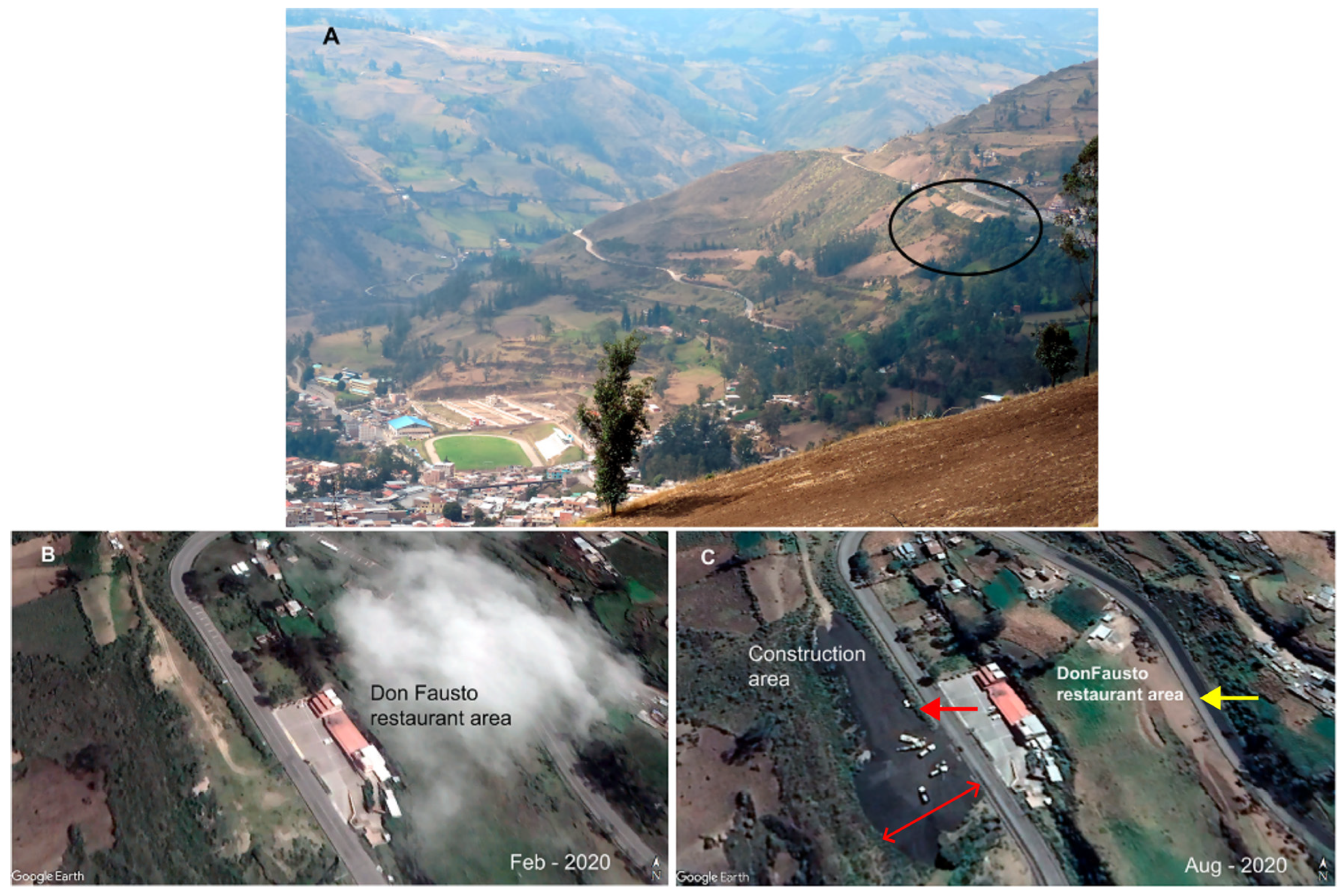
  • 2 and 3 November 2022. After a technical inspection of the Shushilcón-La Elegancia area (southeast of Alausí village), the authors did not identify any abnormal behavior in the geomorphology of the surroundings or on the E-35 Roadway in the area where the head of the landslide was to occur (the Don Fausto restaurant area). Moreover, a material deposit of anthropic origin was identified in front of the mentioned restaurant and close to the E-35 Road (Figure 6A,C). Regarding this fill, it was found that it was for the project construction of the Land Transportation Terminal [28]. The project, located in front of the Don Fausto restaurant, was proposed as a bus stop and tourist viewpoint. It was determined that the structure did not exist in February 2020 (Figure 6B, analyzing Google Earth Pro images), and it appears that the construction started before 29 August 2020 (Figure 6C). The structure had an area of approximately 3250 m2 and 4800 m2 at its base with a height of 6 to 10 m. The aforementioned anthropic body had an approximate volume between 47,000 and 79,000 m3 (78,000 to 130,000 tons in weight considering about 1.65 g/cm3 of material density). Additionally, another older fill as a flat platform can be identified at the head of the area (east of the restaurant), which can be related to cut-and-fill material from the construction of the E-35 Road in the 1980s (see yellow arrow in Figure 6C).
  • 12 November 2022. Extracted from the frames of an amateur video [29], the recording of the route over one vehicle (playing a wooden car competition) could identify that there was no evidence of damage on the E-35 Roadway in the area of the head of the landslide (Figure 7A).
Figure 6. (A) A broad view of the location of the anthropic landfill between the Casual and Nuevo Alausí neighborhoods (black oval). That anthropogenic deposit was located in the head of the area of the landslide (the Don Fausto restaurant is to the right of the oval). The slide materials would cover the football field in the picture’s left corner. (B) On 4 February 2020, it can be noted that no anthropic landfill was in front of the restaurant, as shown in the picture [17]. (C) On 29 August 2020, it can be seen in the image that black landfill was deposited in the area (red arrow) where some earth machinery was working [17]. The yellow arrow shows where the cut-and-fill material was deposited from the E-35 Road construction, and the double arrow line shows a 55 m length.
Geohazards 06 00028 g006
  • 9 December 2022. A small collapse was reported on the E-35 Roadway. However, on 23 and 30 December, no report indicated an increase in hazard or an unstable landslide condition [30].
  • 17 January 2023. The pavement of the E-35 Road showed the presence of cracks, with a size of 3 to 5 cm in width and 7 to 11 m in length. Also, the Casual community people informed the municipality of cracks 2 to 24 cm wide, 20 and 13 cm long, and 0.77 to 1.00 m deep being identified by the IIGE [31] with a 280° direction. The neighbors included land settlement reports for the area.
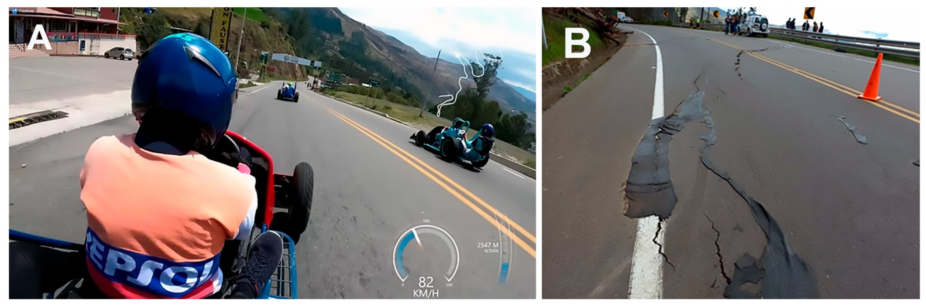
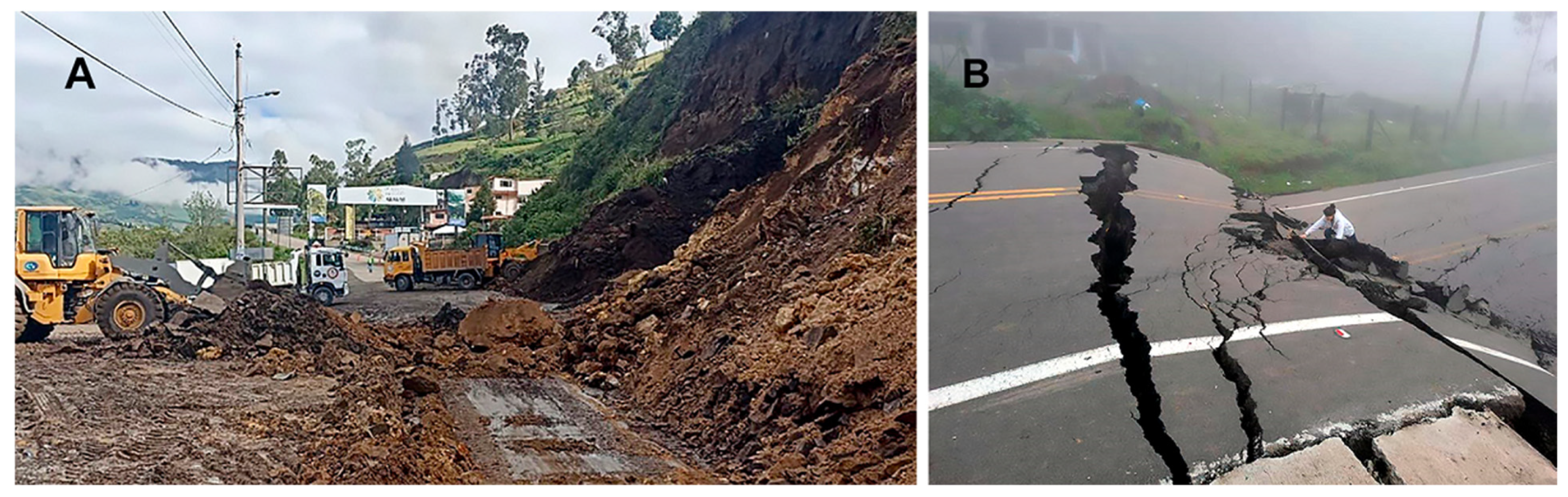
  • February 2023. On the 8th, a local online news report [32] showed the effects of the increase in cracks and settlement in the E-35 Road (Figure 7B), and on the 19th, the Yellow Alert was established by the Government over a 247-hectare zone [33]. That included the Aypud and Casual communities (no urban areas) and La Esperanza, Control Norte, Nueva Alausí, Pircapamba, and Bua (urban neighborhoods). The exceptional pluviometry that fell over the area this month was that some minor landslides affected the steep slope of the E-35 Road, 100 m down the abovementioned restaurant, and up to 10 m high slope runs through the road (Figure 8A).
Figure 7. (A) A picture from video footage shows the pavement condition on the E-35 Road. The race could not have been performed if the road had been cracked (4:25 min frame from a camera over a non-motorized car in front of the Don Fausto restaurant, modified from a video posted by César Zumba [29]). (B) Some cracks developed on the E-35 Road at a close location to the picture in (A) (just at the head of the landslide) on 8 February 2023 (modified from [32]).
Geohazards 06 00028 g007
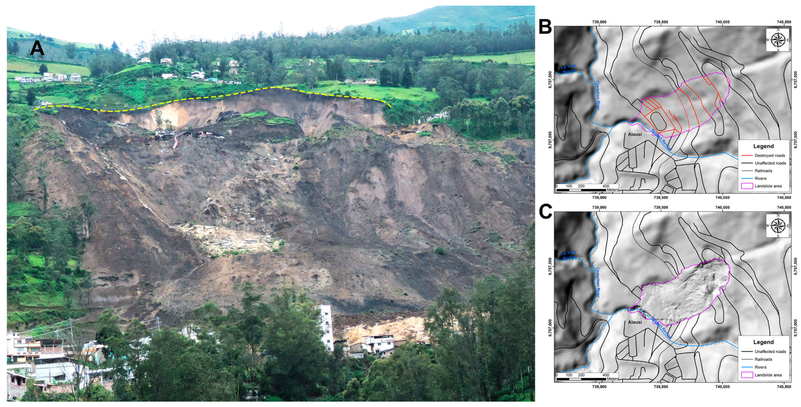
  • 10 to 16 March 2023. The Risk Management Secretariat (SGR, in Spanish) reported 24 cracks distributed around the potential landslide head (open from 5 to 31 cm and with depths up to 2.7 m). Some geophysical surveys were performed crossing the area where the cracks had appeared (properties, homes, and the E-35 Road). It was concluded that a landslide could happen, affecting the nearby stadium neighborhoods and reaching the Ayapán ravine and the Alausí River. A potentially dangerous polygon was indicated, and the yellow alert declaration to the population was ratified [33]. On the 16th, the main road E-35 was closed due to the big settlement, cracks, and the possibility of an incipient landslide [30].
  • 18 March 2023. Centered on Puná island and near the Balao village (Guayas province, Ecuador), a 6.6 Mw earthquake with a depth of 63.1 km happened. The epicenter was 120 km away from Alausí to the Southwest, and an intensity value of IV on the EMS macroseismic scale was reported for the Chimborazo province. The neighbors reported it as strong to weak and referenced a small landslide as a possible effect of this event [6].
  • 23 to 26 (in the morning) March 2023. The local news and neighbors report apertures of up to 60 cm, with depths over 1.8 m, and heights of 2.0 m for the cracks (Figure 8B). Some people heard bass sounds and cracking noises ([34] and Ms. Berrones, geologist, personal communication). At 21:13 h, 26 March, the landslide happened.
Figure 8. (A) Government machinery works to clean and clear debris to open the E-35 Road, South of the Don Fausto restaurant, in the Casual sector, 19 February 2023 [30]. (B) Impressive open cracks and vertical displacement (over four meters) 50 m North of the Don Fausto restaurant. The picture was granted by S. Berrones, a geologist, who took it on 26 March 2023, in the morning, a few hours before the event happened.
Geohazards 06 00028 g008

3. Anthropogenic Factors in the Landslide’s Occurrence

Landslides as natural events are driven by multiple causes (tectonic, climatic, and/or human activities) as compositional factors, and they can also be triggered or accelerated by several human activities [35], including the following:
  • Deforestation. Uncontrolled agricultural practices, such as the removal of trees and the loss of vegetal cover, are one of the causes of the destabilization of the soil. In the steep hillslopes with an important presence of vegetation, it contributes to the mechanical stability of the shallow soil mantle [36], so reducing the vegetal cover increases the instability of slopes through the alteration of hydrological and geotechnical conditions [37]. That allows the surface to increase erosion due to root reinforcement losses and reduces the wetness conditions (evaporation and rainfall interception), which tends to decrease slope stability [37]. Also, the loss of soil cohesion and the decrease in shear strength can be consequences of deforestation and it increases the susceptibility to landslides [38]. The deforestation processes enhance the landslide risk by 16%, increasing the probability of landslide occurrences after 5 to 7 years [39] or as Depiker et al. [40] indicate, it can produce a landslide peak in the next 15 years (approximately) and increases the landslide erosion by a factor of two to eight. In that context, the increase in the probability of landslide processes can be developed, suggesting that land uses and their changes control them, especially in prone areas or mountain regions where those changes can lead to a disaster event, including human fatalities. Thus, deforestation can bring fatal consequences to the sustainable economic development of an indicated area [39].
    In Ecuador, between 1990 and 2014, the native forests experienced a 40% reduction, with the lowest probability of persistence in the elevation band of 2800–3300 m, where agricultural land and planted forest continually replace them [41].
  • Construction and building expansion. The need for new areas to build and expand the urban or industrial zones can alter the stability of natural slopes when cut-and-fill is applied to a landslide-prone area or a steep slope [42,43]. When homes and buildings are constructed, the terrain is altered to create flat areas, so the original balance and equilibrium of the ground surface are affected. Human activities can weaken internal and external slope conditions by altering natural water drainage, increasing loads, or increasing the likelihood of slope failure. The land use type and the cutting or filling at the base or top of a slope can destabilize natural support by adding additional weight or eliminating weight, creating an imbalance between the driving forces and the resisting forces. Furthermore, water management (surficial or underground) lacks deep studies that can contribute to saturation or erosion when drainages are modified [42,44].
  • Mining Activities. Mining activities involve massive excavations, including the alteration of natural drainages and the vegetation removal of slopes, which can reduce soil cohesion and increase water infiltration, creating favorable conditions for landslides [45,46]. Mining can also contribute to landslides by induced vibrations (explosives or deep excavations without adequate structural support). Similarly, mine waste dumps are prone to failure when the geotechnical parameters of the ground are not considered [45,46].
  • Water Management Practices. In landslides, the influence of water plays an important role, either as a conditioning or triggering factor, due to the presence of a water table, rainfall infiltration, or groundwater. This is on both natural slopes and artificial slopes generated by natural terrain cuts or the construction of embankments. Therefore, a hydrostatic analysis is important for studying slope stability since the presence of water reduces soil strength and increases the forces that generate instability. The influence of water on the occurrence of landslides can manifest itself through rainfall, which alters humidity and pore pressure, generating erosion; anthropogenic activities such as irrigation, blockage of natural drains due to urban expansion, water leaks from utility networks, inadequate maintenance of drainage and sub-drainage systems, and deforestation, which causes hydrological changes, among others. Rainfall is generally the most common triggering factor since the most significant problems associated with slope instability occur in areas with the highest rainfall. Therefore, it is important to emphasize that the intensity or duration of rainfall and the occurrence of a landslide depend on the soil type. The soil’s surface moisture content and water movement from the ground surface to the soil and subsoil determine the slope’s runoff and infiltration factors. Suppose reliable rainfall information is available for an area. In that case, the relationship between intensity and duration can be quantitatively estimated, as well as the volume of water that has fallen in a given period that coincides with a landslide. In conclusion, water constitutes one of the main factors that interact with the occurrence of mass movement processes.
    Therefore, its analysis is important for slope stability modeling since the increase in pore water pressure decreases the effective stress and, consequently, the shear strength. Since water is one of the most important elements of nature, it is necessary to consider proper management in areas susceptible to mass movements by implementing the necessary drainage and sub-drainage works to ensure the harmonious coexistence of this element with nature [47].
  • Urbanization. Mohanty et al. [48] point out that urbanization contributes to the increase in frequency and severity of landslides due to the creation of scenarios where natural and anthropogenic factors combine to destabilize slopes. Urbanization processes involve changes in land use, deforestation, and alteration of drainage patterns [48,49]. The construction of urban areas and all their infrastructure generates significant disturbances in the geological and topographic environment, mainly due to decreased vegetation cover and slope cuts [48,50]. Accelerated urbanization, coupled with poor and haphazard urban planning, increases hazard and vulnerability [49], as it alters slope stability by allowing housing construction in areas with delicate topographic balances and modifying drainage patterns [48].
    Precipitation is the main triggering factor for landslides, and urbanized areas are more sensitive to changes in precipitation patterns. Key factors explaining this behavior include the expansion of impermeable cover (roofs and roads), changes in runoff and infiltration, modification of the basin’s water balance, and the loss of vegetation, which affects evapotranspiration processes [51]. In the case of soil waterproofing, it is related to surfaces covered with asphalt and concrete, the purpose of which is to prevent water infiltration, which increases surface runoff. This process is exacerbated during intense precipitation events [48]. Furthermore, many construction activities are carried out without adequate geological assessments, significantly increasing landslide risk [48].
  • Road Construction. Human activities such as road construction and agricultural irrigation development on steep slopes are not considered in Ecuador’s landslide assessments. Wieczorek [52] indicates that human activities such as road excavations and irrigation processes also trigger landslides. Meusburger and Alewell [53], in a study conducted in the Alps, indicate that land use poses a risk to soil stability in that region. Brenning et al. [3] indicate that mountain roads in developing countries increase the incidence of landslides due to often inadequate drainage systems. Highland and Bobrowsky [54] point out that drainage alterations and modifications are other common human-induced factors that can initiate landslides.
  • Agricultural Practices. Improper agricultural practices like overgrazing or plowing on steep slopes can lead to soil erosion and increased landslide risk [55].
  • Heavy Machinery Use. Using heavy machinery in human activities such as construction increases the risk of landslides. By 2016, 52% of the events were recorded in China due to urban construction works, while in other countries, such as India (30%) and Nepal (43%), all events were due to road construction works [35]. In this sense, excessive equipment weight and constant vibrations can negatively affect soil stability. The weight of agricultural machinery increases stress levels in the soil, leading to greater compaction and decreased hydraulic conductivity [56]. On the other hand, transport generally can be considered heavy machinery due to its high traffic. That is the case in Romania, where road construction and traffic vibrations contribute to the emergence and reactivation of mass movement processes, affecting the population, the environment, transport infrastructure, and productive lands, necessitating mitigation measures to reintegrate these areas [57].

4. Results

Before analyzing the anthropogenic factors, it can be noticed that the surroundings of the affected area have a high level of seismicity. That is related to the Pallatanga fault with a cortical activity (up to 35 km in depth) where earthquakes’ local moment magnitudes (Mw) were between 3.90 in 2022 and 4.49 in 2020. A seismic nest is located 120 km northwest of Alausí (452 events in 2020, 342 in 2021, and 471 in 2022). Even though there were close areas with seismic activity, the Geophysical Institute (IG in Spanish) had not reported intensities in the study area and its surroundings that can affect the global stability of slopes or generate a mass movement (values too low to be considered as a trigger factor and no coseismic landslides had been noticed in the area, or they were not known) [6,31].
On 18 March 2023 (eight days before the landslide event), a 6.64 Mw earthquake (63.1 km in depth) happened on Puná Island (Guayas province, 120 km far away from Alausí to the west) and a macro seismic intensity of IV was reported in the Alausí canton (which corresponds to an acceleration on the ground from 0.014g to 0.039g). That earthquake, named the Balao event, activated minor displacements in the Alausí landslide area and triggered a small surficial landslide close to the E-35 Road in a southwest direction (affecting only the soil). From that date, the surficial ruptures observed in the road pavement related to the landslide increased in size (see Figure 8B). Also, through their analysis, we note that the IG indicated that it was not the trigger factor for the landslide at that moment [31].
The anthropogenic factors to be analyzed here have the limitation that no baseline of knowledge was available. The data we collected and the publication’s analysis were the basis of the evaluation. At the moment, geotechnical parameters have been impossible to acquire, so the generation of a numerical model to proceed with the definition of safety factors or even the definition of the rupture trace is still under investigation. Conversely, Ecuador lacks a dense net of pluviometry equipment at the national level. The pluviometry data are only collected and registered in the principal cities, together with the changing orography and the stepped topography (small micro-climate areas with important pluviometry changes), which made the interpolation hard to perform.
As previously said, through the SNGR, the Ecuadorian Government performed some surveys [22], but without laboratory assays, which only clarified the geological stratigraphy and the permeability of soil and fractured rocks. Also, the complex configuration of the landslide-affected volume, including soils (overburden) and rocky basement, made it impossible to perform a simple analysis of the rupture process. However, the investigation team is working on defining the shallow materials and the basement through projects involving the landslide area, the surroundings, and the potential for repeating this type of event in closed areas.
The identifying anthropogenic factors contributing to the landslide in the Casual-Nuevo Alausí investigated area were found and summarized in five of the eight points analyzed in the previous section. The main anthropogenic factors identified that contributed to and affected the mass movement were the following:
  • The natural slopes were altered by road construction. The road construction of the old Panamericana Highway involved the removal of soil and rocks (cut and fill) in the early 1930s in the middle of the landslide area (see the roads affected in Figure 1A). The scars made over the ground surface increased the infiltration of runoff water and generated new loads on the ground (different from natural soil) and vibration or dynamic stress due to the circulation of vehicles and heavy trucks. The pathway of that road was changed to the actual E-35 Road (new Panamericana Highway) due to several landslides north of the study area. That generated a new modification of the natural relief and topography at the upper area of the investigated landslide (that road was cut at two elevations and is still broken). On both sides of that road were identified fills of the materials cut in the construction (see Figure 6C, yellow arrow), increasing the load in an area of very steep slopes (>35°). The cut naked slopes have had an unstable equilibrium, which has produced surficial landslides in rainy seasons with small sizes (less than 1000 m3 [8]) and created a new angle in the slope (as a natural process of reaching the equilibrium on materials). One of the standard practices in Ecuador, when falling material from a landslide invades a road, is the removal of those fallen materials without carrying out stabilization studies or improvements to the slope, hoping that this action will stabilize or at least temporarily resolve the problem (see Figure 8A). Those construction processes also contribute to the change in natural vegetation cover, which can be a factor to be considered in the erosion/infiltration of the water and later destabilizing processes of the materials that form the slopes. Removing vegetation cover reduces the soil’s ability to retain water, and it is a way to increase the erosion processes, especially on steeply sloping terrain [10,12].
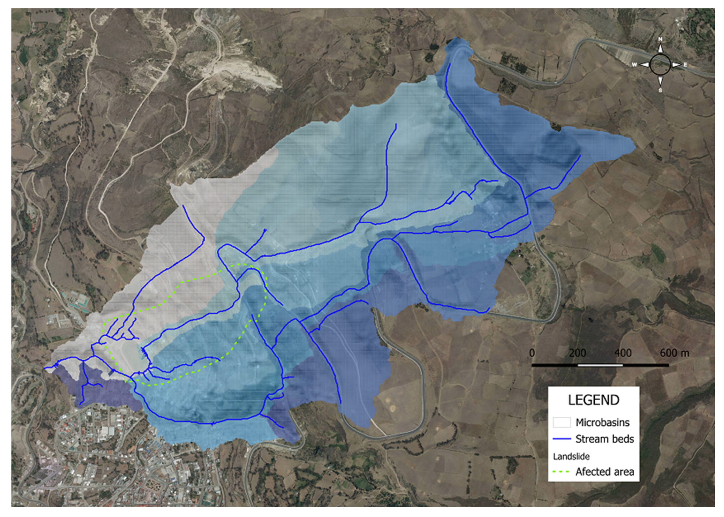
  • The inadequate design and maintenance of the roads increased the sliding potential. In that case, as a result of the previous point, the high-cutting slope designs need periodic overall control and maintenance after rainy periods or small landslides. Landslides can appear where the soil or rock has limited stabilization, or the weight increment (saturated materials) can potentially trigger the movement. Properly maintaining surficial water control runoff (through ditches, tubes, and trenches) in the crown and the toe, or rebuilding or redesigning the slope inclination, is needed as constant work. The investigation discovered several anthropic streams whose drainage was directed towards the crown of the landslide (see Figure 9A). In Figure 5, the natural traces of streams have an anthropogenic shape with forced curves that correspond to the E-35 Roadway and cut the natural flow of streams. Those deviations are present in the Aypud area (northeast of the crown of the landslide), but it is more evident just at the upper area of the affected area where it was observed that the old stream filled between the two branches of that road (there is a narrow descending curve, and the drainage runs at the side ditches of the road). Those actions must consider factors such as local geology and climatic conditions, which can result in instability (especially when climatic conditions are changing, such as in Ecuador or when considering climate change) [41,58].
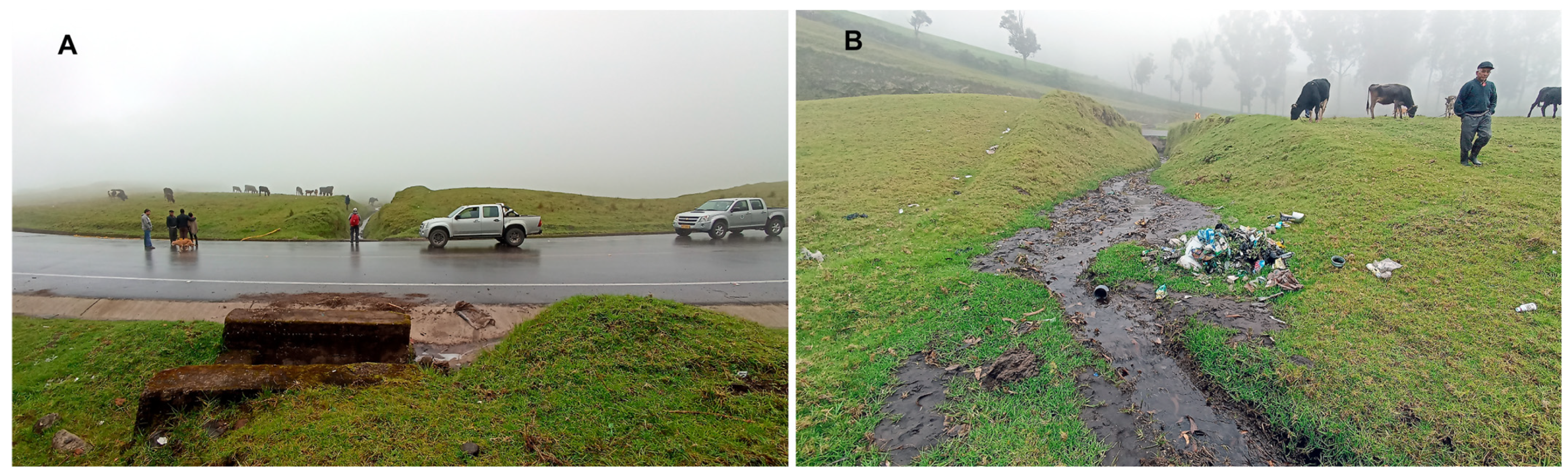
  • Water drainage and runoff direction alteration. During heavy rainy periods, similar to the days before the landslide event in Alausí, the water can erode constructed and bare-naked slopes, weakening their internal structure (Figure 8A). That is especially important in areas with recurrent or common rainfall periods (including climate change variations) [59,60]. In addition, the lack of adequate drainage (internally in the slope) exacerbates the problem by allowing water to accumulate on slopes, increasing pressure on the soil [12]. It was observed that not only did the road ditches direct the water towards the upper part of the landslide, but the owners and inhabitants also drained that water to points at the top of the landslide (see Figure 9B).
  • The impact of human settlements. The need for access to the occupation of new areas, which can be considered a product of road construction and better ways, is often accompanied by urban development in the nearest areas to those ways (for example, the new trace of the E-35 Road). In the late 1990s, the urban area of Alausí increased by 40% in surface area, where the buildings were located, toward the landslide event that had occurred [61]. That signified increased human activities over the northeast, including excavating slopes to acquire new areas (for example, the Don Fausto restaurant area at the top of the landslide). Also, an important factor when increasing the network of roads and communication ways is that they are covered by asphalt or concrete, which redirects the streams or even fills the waterways (as was evidenced by the investigation in the same area as the restaurant). Of course, the new buildings add extra weight to the slope materials. Human settlements can also increase the contribution to water content in the soil by throwing gray water and waste products that infiltrate the ground (in the Aypud and Casual neighborhoods, no sewerage system was developed, and they used to throw these products into the surface water streams). Additionally, the lack of garbage management or inappropriate disposal (always illegal or “pirate” throwing) accumulates waste in waterways so that the water carries it away from houses and inhabited areas, which can clog or make some embankments in streams (see Figure 9B). That was evidenced in several places in rural Ecuadorian territory, as indicated in Troncoso et al. [15]. Also, inappropriate agricultural practices, where the remobilization of surficial soil and irrigation water (in high volumes) can also increase the risk [60]. In the Aypud area, it was observed that more than 5 l/s could be unused and sent to streams or over the fields and growing areas.
  • New urbanization pressure and potentially developed areas. The last anthropic factor analyzed, which can be considered a compilation of the previous ones, was the pressure of urbanization without the rules of established municipality planning. Some examples were the bus terminal construction (see Figure 6A–C), the football field and coliseum (Figure 6A), or the buildings close to the last items. The buildings and the increasing alteration of the topography, or some of the previous points analyzed, affected the stability of the landslide area.
Also, the studied area has a complex geology in its basement and soil. Tectonic structures fractured the rocks, giving them a high permeability grade [22]. The basement investigation evidenced high degrees of hydrothermal alteration (see Figure 4), which weakened the rock strength and made it easy to mobilize and develop excavation processes by people [23,24]. Additionally, the low permeability of the Cangahua Formation soils (one of the most important overburden materials in the area), coupled with the high-grade slopes, forced the constructors to fill or change the direction of the stream channels, thereby affecting the hydrology.
It is also interesting to note that those streams have seasonal behavior, and the water flow volume is low or nonexistent most of the year. That gives the population a false sense of security, which tends to underestimate their importance, causing them to overflow in times of heavy rain. Consequently, the overflow water generates new changes in the way, new infiltration areas, and new alteration of the slope materials (erosion, weathering, and alteration processes).
Deforestation and the changes in agricultural plantations also contribute to the geomorphological changes. The bare soil to plant productive crops for consumption is more prone to erosion than soil covered in vegetation. Also, it is important to note that some agricultural properties plowed the soil for cultivation in the direction of the slope and did not follow the contour lines, which increased the water erosion process. Moreover, autochthonous trees were eliminated or significantly decreased, having been replaced with eucalyptus as a production crop. That type of tree has strong and thick roots that can reach deep into the soil and the rocks. It can initially be a good soil consolidation solution but not over the long term because it can open cracks, increase the fracturing in rocks, and create new pathways for water infiltration.
New neighborhoods and the expansion of the urban area bring new opportunities to the population, but they are accompanied by topographical and geomorphological changes (cut and fill). The territorial development plans are often “forgotten”. Thus, susceptibility levels rise, increasing vulnerability.
Table 2 summarizes some of the analyzed anthropogenic factors’ results and evaluates the relative importance considered in the Alausí landslide process. The limitations in the data related to the factors before the event and the low level of geotechnical parameters also limit the generation of a susceptibility map to delineate those factors over the landslide area. Some factors, such as deforestation, cannot be evaluated because no baseline data are available. Also, mining activities are not present in the area.

5. Discussion

According to the IAEG Commission on Landslides [8], the Alausí landslide was of small magnitude considering the area and volume displaced [7], in contrast with other studies and publications, such as those of the PNUD [61], which indicated a macro-slide-type size. However, the impact was huge due to the high population exposure and the existing infrastructure in the area (65 dead people plus 10 people who disappeared out of the 93 total registered in 2023, as the UNDRR DesInventar database indicated, and 24 hectares affected). The latter resulted from the lack of territorial planning and a correct analysis of the natural hazards (including the lack of detailed geological studies). It should be noted that the development planning for the urban construction area in the Alausí PDOT (Spanish abbreviation) [20] included the neighborhoods that were affected by the landslide. That is a repeated consideration in several authors’ investigations through the Andean countries like Venezuela, Colombia, or Peru, which have similar characteristics to Ecuador (social, environmental, and topographical) [59,62,63].
The triggering factor was the oversaturation of the ground, according to the PNUD report [61] and other publications [6,31], which was a product of the high rainfall recorded in the area for several months before (see Table 1). However, both in the field visits of this research group, as well as in the verbal communications with the inhabitants of the area (it was indicated that the affected people came out dusty, and the presence of dust on the roofs of nearby houses was determined), the fallen material presented a low to medium humidity percentage, but its saturation was not observed. That agrees with the low permeability values obtained in the tests carried out in the area, which indicated nearly impermeable materials at the surface [7,22]. As indicated, due to the lack of Ecuador landslide investigations and the high precipitation season, most of the government reports’ conclusions pointed to saturation as the main triggering factor. Moreover, over the field data acquisition in the rainy season, it was demonstrated that the overburden remained dry or had a low humidity content by excavating the first meter under the vegetal soil.
Consequently, the water accumulation in soils and rocks, one of the most important factors in landslide processes [59], must not be considered a determining factor when arguing the trigger cause of the landslide rupture, but, of course, it could be a complementary factor in the process (as a long period of rainy days before the start). Also, it is necessary to consider that the rupture process lasted about 4 months (it began to become evident in December 2022) and the Balao earthquake affected it and accelerated the process (see Figure 8B) [6]. That is a future line to investigate and quantify.
It was shown that the expansion actions of the Alausí urban center built and occupied areas previously classified as highly susceptible [20]. The rocky substrate state, being highly altered and fractured, played a role that favored the rupture through the basement massif in areas like this one, where steep slopes are predominant, including the E-35 Road construction works (excavation and fill) which modified the natural slopes and caused various changes in the natural drainage pattern.
All those analyzed factors generated an increase in susceptibility that was not assessed then. One of the needs for territorial and ordination planning (over Ecuador’s cantons) is the evaluation of susceptibility based on a geographical data analysis (made from cartography and topographic maps at a 1:50,000 scale or less detailed), and no data-driven or accurate reviews further in time were conducted. That also limited the availability of baseline data or deeper information to manage or study natural hazards. As Bezada or Hermelin y Hoyos indicated [62,63], the increase in population has consequences, like the occupancy of dangerous zones and the lack of governmental application of laws, which have led to fatal situations in the Andean countries (for example, the invasions of areas are regularized by the government institutions yearly). The policies about regulations and disaster prevention programs are controlled by politicians, not technicians, whose studies are only to comply with the law [63].
It is not easy to compare the anthropogenic factors involving Ecuador and the Andean countries with other locations and places worldwide. The social conditions and the lack of law enforcement give those countries a special situation. The rural poverty of the people and governmental budget restrictions (only focusing on remediation actions and not on preventing or studying the phenomenon), together with a poor collective memory of similar events [62,63], increase the vulnerability. For example, the Josefina landslide (Ecuador, 1993), another big landslide, was caused by anthropogenic activities (mining activities) after an intense rainy period. Nevertheless, no studies were conducted (only over the dam’s crest created after the event to open it), and the event remains uninvestigated [5].
On the other hand, technicians monitor the slopes from the perspective of natural events without considering that human actions (all those presented here) could negatively impact the slope stability [59,63]. As a line of future research, this interaction between natural events and human actions and activities should be analyzed in depth. These studies should have a chronology of several decades to understand the process, for example, the influence on changes in stream directions and the water use for irrigation and agricultural activities. Any land use must be based on solid knowledge of the environment: geology, hydrology, hydrogeology, and natural hazards. In this way, urban planning and thus vulnerability can be managed. The PDOT reports in Ecuador focus more on the social aspect and its relations than on this point [20,61].

6. Conclusions

Anthropogenic factors and human actions negatively impact landslides in urbanized areas, as has been the case in Alausí and other landslides in Ecuador.
Precipitation is always considered a critical factor in triggering landslides; however, the evidence collected indicates that the surface layers (cangahua soils formed from Cangahua Formation alterations) were not identified as saturated (although they did contain moisture) and that the rock (basement) had high permeability. That indicated no potential for water accumulation in the soil to increase the specific weight of the materials involved in the Alausí landslide enough to be considered a crucial factor (no saturation was identified). Nevertheless, the water could flow under the soil overburden (cangahua materials and volcanic avalanches) and saturate the surficial altered and fractured rocky basement (which was involved in the landslide). That is a point to be analyzed further in the future.
Although the vulnerability was not analyzed or quantified, having been classified as a small landslide (which involved the road platform only at the first moments), the consequences were enormous (65 deaths, injuries, damage to the E-35 road and electricity and water systems, and homes). That resulted from high exposure related to the lack of or inadequacy of land use and the application of urban planning and analysis.
Landslides must be analyzed when they begin to exert anthropogenic influence on the territory. Understanding the geological processes (internal and external) and the consequences that human alterations can have is imperative.
To achieve this, all factors must be assessed from a long-term sustainability perspective, for example, waterproofing processes resulting from the construction of roads and streets, which increase the magnitude, recurrence, and potential of the conditioning and/or triggering factors (geological materials and hydrogeology).
Finally, in the future, a holistic approach to actors (anthropogenic part) and conditioning and triggering factors (geological part) of medium- and long-term interactions must be incorporated.

Author Contributions

Conceptualization, L.P., O.A.-P., L.T., A.M. and E.I.; methodology, F.J.T., L.P., F.V. and S.S.; investigation, O.A.-P., R.A., L.P., S.S., F.V. and L.T.; data curation, F.J.T., L.P. and A.M.; writing—original draft preparation, O.A.-P., L.P., E.I., L.T. and S.S.; writing—review and editing, F.J.T., F.V. and R.A.; visualization, A.M. and S.S.; supervision, L.P. and F.J.T. All authors have read and agreed to the published version of the manuscript.

Funding

This research received no external funding.

Data Availability Statement

The original contributions presented in this study are included in the article. Further inquiries can be directed to the corresponding author.

Acknowledgments

Thanks to the support provided by the Central University of Ecuador (UCE) authorities to the students and professors of the Faculty of Geology, Mining, Petroleum, and Environmental Engineering and the Geology Department for collecting and managing the information in the affected area. We also want to thank the Decentralized Autonomous Government of Alausí canton (G.A.D. del cantón Alausí) and its authorities, who supported us with his comments, and information from the Secretaría de Gestión de Riesgos from the Ecuadorian Governmental Administration. Special thanks to Soledad Berrones in our faculty, and his brother, who granted us some pictures.

Conflicts of Interest

The authors declare no conflicts of interest. Google Maps (www.maps.google.com, accessed on 20 February 2025) and Google Earth (https://www.google.es/intl/es/earth, accessed on 20 February 2025) are trademarks and their images are free of charges for investigation purposes.

References

  1. Cruden, D.M. A Simple Definition of a Landslide. Bull. Int. Assoc. Eng. Geol. 1991, 43, 27–29. [Google Scholar] [CrossRef]
  2. Cruden, D.M.; Varnes, D.J. Landslide Types and Processes. In Landslides: Investigation and Mitigation; Turner, A.K., Shuster, R.L., Eds.; Transportation Research Board: Washington, DC, USA, 1996; Volume 247, pp. 36–75. [Google Scholar]
  3. Brenning, A.; Schwinn, M.; Ruiz-Páez, A.P.; Muenchow, J. Landslide Susceptibility near Highways Is Increased by 1 Order of Magnitude in the Andes of Southern Ecuador, Loja Province. Nat. Hazards Earth Syst. Sci. 2015, 15, 45–57. [Google Scholar] [CrossRef]
  4. Bravo-López, E.; Fernández Del Castillo, T.; Sellers, C.; Delgado-García, J. Analysis of Conditioning Factors in Cuenca, Ecuador, for Landslide Susceptibility Maps Generation Employing Machine Learning Methods. Land 2023, 12, 1135. [Google Scholar] [CrossRef]
  5. Alonso-Pandavenes, O.; Torrijo Echarri, F.J.; Garzón-Roca, J. Sustainable Management of Landslides in Ecuador: Leveraging Geophysical Surveys for Effective Risk Reduction. Sustainability 2024, 16, 10797. [Google Scholar] [CrossRef]
  6. Instituto Geofísico-Escuela Politécnica Nacional Observaciones Sobre el Deslizamiento del 26 de Marzo de 2023 en Alausí (Provincial de Chimborazo). Informe. Quito 2023, 22p. Available online: https://www.igepn.edu.ec/portal/informes/otros/deslizamiento_alausi.pdf (accessed on 23 June 2023).
  7. FIGEMPA Evaluación del Deslizamiento Casual-Nuevo Alausí y Su Zona de Influencia. Informe Final de Inspección de La Comisión de Geología; FIGEMPA—Universidad Central del Ecuador: Quito, Ecuador, 2023; p. 25. Available online: https://www.facebook.com/figempa.geologia/photos/pb.100063704644867.-2207520000/2255106044697460/?type=3 (accessed on 23 June 2023).
  8. IAEG Commission on Landslides Suggested Nomenclature for Landslides. Bull. Int. Assoc. Eng. Geol. 1990, 41, 13–16. [CrossRef]
  9. Instituto Geográfico Militar Emergencia Por Deslizamiento en Alausí 2023. Quito. 2023. Available online: https://www.geoportaligm.gob.ec/mapstore/#/geostory/shared/6957/section/8390e347-bf24-4490-a4ed-fc39ceff6010 (accessed on 20 August 2024).
  10. Cobos-Mora, S.L.; Rodriguez-Galiano, V.; Lima, A. Analysis of Landslide Explicative Factors and Susceptibility Mapping in an Andean Context: The Case of Azuay Province (Ecuador). Heliyon 2023, 9, e20170. [Google Scholar] [CrossRef]
  11. Dai, F.C.; Lee, C.F.; Ngai, Y.Y. Landslide Risk Assessment and Management: An Overview. Eng. Geol. 2002, 64, 65–87. [Google Scholar] [CrossRef]
  12. Palenzuela Baena, J.A.; Soto Luzuriaga, J.; Irigaray Fernández, C. Characteristics of Rainfall Events Triggering Landslides in Two Climatologically Different Areas: Southern Ecuador and Southern Spain. Hydrology 2020, 7, 45. [Google Scholar] [CrossRef]
  13. Soto, J.; Galve, J.P.; Palenzuela, J.A.; Azañón, J.M.; Tamay, J.; Irigaray, C. A Multi-Method Approach for the Characterization of Landslides in an Intramontane Basin in the Andes (Loja, Ecuador). Landslides 2017, 14, 1929–1947. [Google Scholar] [CrossRef]
  14. Puente-Sotomayor, F.; Egas, A.; Teller, J. Land Policies for Landslide Risk Reduction in Andean Cities. Habitat Int. 2021, 107, 102298. [Google Scholar] [CrossRef]
  15. Troncoso, L.; Torrijo, F.J.; Ibadango, E.; Pilatasig, L.; Alonso-Pandavenes, O.; Mateus, A.; Solano, S.; Cañar, R.; Rondal, N.; Viteri, F. Analysis of the Impact Area of the 2022 El Tejado Ravine Mudflow (Quito, Ecuador) from the Sedimentological and the Published Multimedia Documents Approach. GeoHazards 2024, 5, 596–620. [Google Scholar] [CrossRef]
  16. Dunkley, P.; Gaibor, A. Geología de La Cordillera Occidental del Ecuador Entre 2–3°S; Programa de Información y Cartografía geológica; CIDIGEM-British Geological Survey: Quito, Ecuador, 1997; p. 162. [Google Scholar]
  17. Google Earth. Available online: https://www.google.es/intl/es/earth/index.html (accessed on 15 June 2024).
  18. Litherland, M.; Aspden, J.A.; Jemielita, R. Los Cinturones Metamorficos del Ecuador; Overseas Memoir of the British Geological Survey Nº 11; British Geological Survey: Nottingham, UK, 1994; Available online: https://archive.org/details/1994-litherland-los-cinturones-metamorficos-del-ecuador-sp/page/n9/mode/2up (accessed on 22 November 2023).
  19. Egüez, A.; ALvarado, A.; Yepes, H.; Machette, M.N.; Costa, C.; Dart, R.L. Database and Map of Quaternary Faults and Folds in Ecuador and Its Offshore Region. Int. Lithosphere Program 2003, 61. [Google Scholar] [CrossRef]
  20. GAD Alausí. Plan de Desarrollo y Ordenamiento Territorial. PDOT Alausí 2020; Diagnóstico Estratégico Territorial; Gobierno Autónomo Descentralizado del Cantón Alausí: Alausí, Ecuador, 2020.
  21. NASA. The POWER Project. Available online: https://power.larc.nasa.gov/data-access-viewer/ (accessed on 25 March 2023).
  22. DAVIMEN Consulting Consultoría. Para El Estudio de Prospección Geofísica y Geotécnica en El Cantón Alausí de La Provincia de Chimborazo; Secretaría General de Riesgos: Quito, Ecuador; Gobierno de Ecuador: Quito, Ecuador, 2024; p. 74.
  23. Ibadango, E.; Oleas, C.; Cordovillo, B. Procesos de Movimientos en Masa en la provincia de Chimborazo. Pyroclastic Flow. J. Geol. 2014. Available online: https://studylib.es/doc/8591459/procesos-de-movimientos-en-masa-en-la-provincia-de-chimbo (accessed on 15 June 2024).
  24. INIGEMM. Mapa de Susceptibilidad Por Movimientos En Masa. Alausí; 2013 (Printed Edition); INIGEMML: Quito, Ecuador, 2013. [Google Scholar]
  25. Pilatasig, L.; Ibadango, E.; Oleas, M. Geología, Recursos Minerales y Amenazas Por Procesos de Movimientos En Masa, Cantón Alausí; Ministerio de Recursos Naturales No Renovables: Quito, Ecuador; Instituto Nacional de Investigación Geológico Minero Metalúrgico: Quito, Ecuador, 2010; p. 56. [Google Scholar]
  26. Ibadango, E. Mapa de Zonificación de Susceptibilidades Por Procesos de Movimientos En Masa Cantón Alausí, Escala 1:100.000; Ministerio de Recursos Naturales No Renovables: Quito, Ecuador; Instituto Nacional de Investigación Geológico Minero Metalúrgico: Quito, Ecuador, 2010; p. 42. [Google Scholar]
  27. GAD Alausí. Ordenanza de Actualización del Plan de Uso y Gestión del Suelo, Regulación de Los Procesos Administrativos de Habilitación de La Edificación, Control del Suelo; de Las Normas de Arquitectura y Construcción; Gestión de Riesgos; Manejo y Gestión del Uso Público y Régimen Sancionatorio; Edición Especial No 651 2022. Available online: https://www.registroficial.gob.ec/edicion-especial-no-651-tomo-iii/ (accessed on 20 February 2025).
  28. GAD Alausí. Acta de Sesiones. No 019-2019; GAD Alausí: Alausí, Ecuador, 2019. [Google Scholar]
  29. Zumba, C. Carrera Coches Alausí 2022—Categoría Llanta Inflada; Alausí, Ecuador, 2022. Available online: https://www.youtube.com/watch?v=AT3RX02f3Is&t=7s (accessed on 2 May 2023).
  30. Ministerio de Transportes y Obras Públicas. Gobierno del Ecuador. Available online: https://www.obraspublicas.gob.ec/ (accessed on 16 July 2023).
  31. Instituto de Investigación Geológico y Energético—Secretaría de Gestión de Riesgos Estudio Geológico-Geofísico Para Generación de Datos Para Estabilidad del Deslizamiento de Alausí 26.03.2023; Geological Report; Comité Técnico Científico, Gobierno de Ecuador: Quito, Ecuador, 2023.
  32. Alausí News Urgente Casual, Alausí. [Facebook Publication]. Available online: https://www.facebook.com/story.php?story_fbid=229843549486414&id=102355268901910ews (accessed on 18 March 2023).
  33. Secretaría de Gestión de Riesgos Informes de Situación Nacional. Site Reports, Deslizamiento Casual, Vía Alausí. Gobierno de Ecuador, Quito, 2023. Available online: https://www.gestionderiesgos.gob.ec/wp-content/uploads/2023/ (accessed on 27 July 2023).
  34. La Prensa Chimborazo [@LaPrensaInforma] Vía Alausí—Chunchi Continúa En Mal Estado. [X Post]. Available online: https://x.com/LaPrensaInforma/status/1638945566359994369prensa (accessed on 25 June 2023).
  35. Froude, M.J.; Petley, D.N. Global Fatal Landslide Occurrence from 2004 to 2016. Nat. Hazards Earth Syst. Sci. 2018, 18, 2161–2181. [Google Scholar] [CrossRef]
  36. Sidle, R.C. Influence of Forest Harvesting Activities on Debris Avalanches and Flows. In Debris-Flow Hazards and Related Phenomena; Springer: Berlin/Heidelberg, Germany, 2005; pp. 387–409. ISBN 978-3-540-20726-9. [Google Scholar]
  37. Lehmann, P.; Von Ruette, J.; Or, D. Deforestation Effects on Rainfall-Induced Shallow Landslides: Remote Sensing and Physically-Based Modelling. Water Resour. Res. 2019, 55, 9962–9976. [Google Scholar] [CrossRef]
  38. Runyan, C.W.; D’Odorico, P. Bistable Dynamics between Forest Removal and Landslide Occurrence: LANDSLIDE VEGETATION DYNAMICS. Water Resour. Res. 2014, 50, 1112–1130. [Google Scholar] [CrossRef]
  39. Muñoz-Torrero Manchado, A.; Antonio Ballesteros-Cánovas, J.; Allen, S.; Stoffel, M. Deforestation Controls Landslide Susceptibility in Far-Western Nepal. CATENA 2022, 219, 106627. [Google Scholar] [CrossRef]
  40. Depicker, A.; Govers, G.; Jacobs, L.; Campforts, B.; Uwihirwe, J.; Dewitte, O. Interactions between Deforestation, Landscape Rejuvenation, and Shallow Landslides in the North Tanganyika–Kivu Rift Region, Africa. Earth Surf. Dyn. 2021, 9, 445–462. [Google Scholar] [CrossRef]
  41. Guarderas, P.; Smith, F.; Dufrene, M. Land Use and Land Cover Change in a Tropical Mountain Landscape of Northern Ecuador: Altitudinal Patterns and Driving Forces. PLoS ONE 2022, 17, e0260191. [Google Scholar] [CrossRef]
  42. Ho, K.; Cheung, R.; Kwan, J. Advances in Urban Landslide Risk Management; SIMSG-ISSMGE: Colombo, Sri Lanka, 2015; p. 29. [Google Scholar]
  43. Falasca, F.; Sette, C.; Montaldi, C. Addressing Land Use Planning: A Methodology for Assessing Pre- and Post-Landslide Event Urban Configurations. Sci. Total Environ. 2024, 921, 171152. [Google Scholar] [CrossRef]
  44. Holcombe, E.A.; Beesley, M.E.W.; Vardanega, P.J.; Sorbie, R. Urbanisation and Landslides: Hazard Drivers and Better Practices. Proc. Inst. Civ. Eng.-Civ. Eng. 2016, 169, 137–144. [Google Scholar] [CrossRef]
  45. Zevgolis, I.E.; Deliveris, A.V.; Koukouzas, N.C. Slope Failure Incidents and Other Stability Concerns in Surface Lignite Mines in Greece. J. Sustain. Min. 2019, 18, 182–197. [Google Scholar] [CrossRef]
  46. Lu, Y.; Jin, C.; Wang, Q.; Li, G.; Han, T. Deformation and Failure Characteristic of Open-Pit Slope Subjected to Combined Effects of Mining Blasting and Rainfall Infiltration. Eng. Geol. 2024, 331, 107437. [Google Scholar] [CrossRef]
  47. Camacho Angarita, L.; Granados Muñoz, C.X. El Agua Como Agente Principal de La Inestabilidad de Taludes; Ediciones Universidad Cooperativa de Colombia: Bogotá, Colombia, 2023. [Google Scholar]
  48. Mohanty, S. Impact of Urbanization on Landslide Incidences in the Indian Himalayan Region. J. Geosci. Insight 2024, 2, 20–24. [Google Scholar] [CrossRef]
  49. Cui, Y.; Cheng, D.; Choi, C.E.; Jin, W.; Lei, Y.; Kargel, J.S. The Cost of Rapid and Haphazard Urbanization: Lessons Learned from the Freetown Landslide Disaster. Landslides 2019, 16, 1167–1176. [Google Scholar] [CrossRef]
  50. Li, G.; Lei, Y.; Yao, H.; Wu, S.; Ge, J. The Influence of Land Urbanization on Landslides: An Empirical Estimation Based on Chinese Provincial Panel Data. Sci. Total Environ. 2017, 595, 681–690. [Google Scholar] [CrossRef]
  51. Johnston, E.C.; Davenport, F.V.; Wang, L.; Caers, J.K.; Muthukrishnan, S.; Burke, M.; Diffenbaugh, N.S. Quantifying the Effect of Precipitation on Landslide Hazard in Urbanized and Non-Urbanized Areas. Geophys. Res. Lett. 2021, 48, e2021GL094038. [Google Scholar] [CrossRef]
  52. Wieczorek, G.F. Landslide Triggering Mechanisms. In Landslides: Investigation and Mitigation; Transportation Research Board: Washington, DC, USA; National Research Council: Washington, DC, USA, 1996; pp. 76–90. [Google Scholar]
  53. Meusburger, K.; Alewell, C. Impacts of Anthropogenic and Environmental Factors on the Occurrence of Shallow Landslides in an Alpine Catchment (Urseren Valley, Switzerland). Nat. Hazards Earth Syst. Sci. 2008, 8, 509–520. [Google Scholar] [CrossRef]
  54. Highland, L.M.; Bobrowsky, P. The Landslide Handbook—A Guide to Understanding Landslides; U.S. Geological Survey Circular: Reston, VA, USA; U.S. Geological Survey: Reston, VA, USA, 2008. [Google Scholar]
  55. Gurung, A.; Gurung, O.; Oh, R. Improper Agricultural Practices Lead to Landslide and Mass Movement disasters: A Case Study Based on Upper Madi Watershed, Nepal. Emir. J. Food Agric. 2013, 25, 30. [Google Scholar] [CrossRef]
  56. Keller, T.; Sandin, M.; Colombi, T.; Horn, R.; Or, D. Historical Increase in Agricultural Machinery Weights Enhanced Soil Stress Levels and Adversely Affected Soil Functioning. Soil Tillage Res. 2019, 194, 104293. [Google Scholar] [CrossRef]
  57. Sestraș, P.; Bilașco, Ștefan; Roșca, S.; Naș, S.; Bondrea, M.V.; Gâlgău, R.; Vereș, I.; Sălăgean, T.; Spalević, V.; Cîmpeanu, S.M. Landslides Susceptibility Assessment Based on GIS Statistical Bivariate Analysis in the Hills Surrounding a Metropolitan Area. Sustainability 2019, 11, 1362. [Google Scholar] [CrossRef]
  58. Chiarle, M.; Geertsema, M.; Mortara, G.; Clague, J.J. Relations between Climate Change and Mass Movement: Perspectives from the Canadian Cordillera and the European Alps. Glob. Planet. Change 2021, 202, 103499. [Google Scholar] [CrossRef]
  59. Torrijo, F.J.; Álvarez, S.; Garzón-Roca, J. A Case Study of a Macro-Landslide in the High Mountain Areas of the Ecuadorian Andes: “La Cría” at the Azuay Province (Ecuador). Land 2024, 13, 2047. [Google Scholar] [CrossRef]
  60. Delgado, F.; Zerathe, S.; Schwartz, S.; Mathieux, B.; Benavente, C. Inventory of Large Landslides along the Central Western Andes (ca. 15–20° S): Landslide Distribution Patterns and Insights on Controlling Factors. J. S. Am. Earth Sci. 2022, 116, 103824. [Google Scholar] [CrossRef]
  61. PNUD—UNPD Análisis Forense del Movimiento en Masa Ocurrido en Alausí el 26 de Marzo de 2023, Utilizando la Metodología FORIN. Nury Bermúdez Coordination, Quito, 2025. Available online: https://www.undp.org/es (accessed on 1 April 2025).
  62. Bezada, M. Natural Hazards and Human-Induced Disasters Triggered by Intense and Episodic Tropical Rains in the Venezuelan Mountains. In Developments in Earth Surface Processes; Elsevier: Amsterdam, The Netherlands, 2009; Volume 13, pp. 115–129. ISBN 978-0-444-53117-9. [Google Scholar]
  63. Hermelin, M.; Hoyos, N. Convulsive Events, a Widespread Hazard in the Colombian Andes. In Developments in Earth Surface Processes; Elsevier: Amsterdam, The Netherlands, 2009; Volume 13, pp. 131–148. ISBN 978-0-444-53117-9. [Google Scholar]
Figure 1. (A) A panoramic view from the west of the 2023 Alausí landslide, one of Ecuador’s largest and most mortiferous landslides in recent years (yellow dashed line marks the landslide crown). (B) Digital elevation model (DEM) of the area before the landslide event (2019). (C) DEM showing the changes in elevation at the affected area in 2023 (modified DEM from free data at the Ecuadorian Military Geographic Institute geoportal [9]).
Geohazards 06 00028 g001
Figure 2. The general location of the studied area (in Ecuador’s map and Chimborazo province’s map displayed in the rectangles to the left) and geological map of the landslide area and its surroundings (modified from Dunkley and Gaibor [16]).
Geohazards 06 00028 g002
Figure 3. A broad aerial view of the Alausí landslide area and its surroundings (the village is at the center of the picture in a dashed purple line, and the landslide is marked in a solid yellow line), showing several scarps (white lines) related to possible ancient mass movements. Also, it includes the Cerro Gampala landslide scarp (in red line). Modified from Google Earth [17].
Geohazards 06 00028 g003
Figure 4. Altered and weathered rock outcrop located to the northwest of the Alausí Coliseum. A predominant white coloration in the rocks (possibly due to hydrothermal alteration) and a high grade of fractures and discontinuities can be observed (A). Outcrop of four extremely weathered rock layers of reddish-brown color (lower layer), creamy-yellowish layer (layer coinciding with blue hammer handle), light gray layer, and yellowish layer, overlain by consolidated superficial clastic deposit (B).
Geohazards 06 00028 g004
Figure 5. Hydrogeological map of the landslide area. The microbasins are delimited from a digital elevation model (DEM) analysis and shown in different blue tones. The stream beds are drawn in dark blue lines, and the landslide-affected area is shown as a dotted green line (modified base map from Google Earth [17]).
Geohazards 06 00028 g005
Figure 9. (A) E-35 Road in the Aypud neighborhood area. The road drainage, collecting of water, and redirecting it to the crown of the landslide area can be seen. (B) Anthropic alteration of the runoff water through a property down the area of picture A. Garbage and human waste accumulate in the waterways and clog the water flow.
Geohazards 06 00028 g009
Table 1. Pluviometry data comparison. First three months’ analysis from three years before the event 1.
Monthly Precipitation Values in Alausí Area (in mm)
Month2020202120222023Difference (Percentage)
January115.6233.995.2699.1471%
February108.5148.0117.9751.1602%
March75.5169.1215.6799.2521%
Accumulated values299.6551.0428.72249.4527.4%
1 Obtained from [21] at the location with geographical coordinates −2.1314 Long, −78.8467 Lat.
Table 2. A summary of the anthropogenic factors and analyzed results for the Alausí landslide occurrence.
FactorAlausí Landslide AreaImportanceObservations
DeforestationLow tree density. Grass and bush predominate.Low to mediumNo baseline. Not analyzed.
Construction and building expansionIncreasing at the landslide toe area and the head. Cut and fill from road and building construction.High to very highBus station construction at the head. Slope intervention. Waste construction materials on the side of the road.
Mining activitiesNot presentNoneNot considered
Water management practicesWater streams modified (agricultural). Road drainage is uncontrolledHighA filled stream that changed the hydrological conditions
UrbanizationIncreasing at the landslide toe and towards the head. No limitations related to high-susceptibility evaluation considered.HighIncreasing the number of people at risk
Agricultural practicesIrrigation processes without control of volumesMediumNo data about the subterranean water
Heavy machinery useHigh-weight vehicle circulation (E-35) and bus station constructionMediumNo data to evaluate
Disclaimer/Publisher’s Note: The statements, opinions and data contained in all publications are solely those of the individual author(s) and contributor(s) and not of MDPI and/or the editor(s). MDPI and/or the editor(s) disclaim responsibility for any injury to people or property resulting from any ideas, methods, instructions or products referred to in the content.

