

The Central Mindoro Fault: An Active Sinistral Fault Within the Translational Boundary Between the Palawan Microcontinental Block and the Philippine Mobile Belt


Abstract
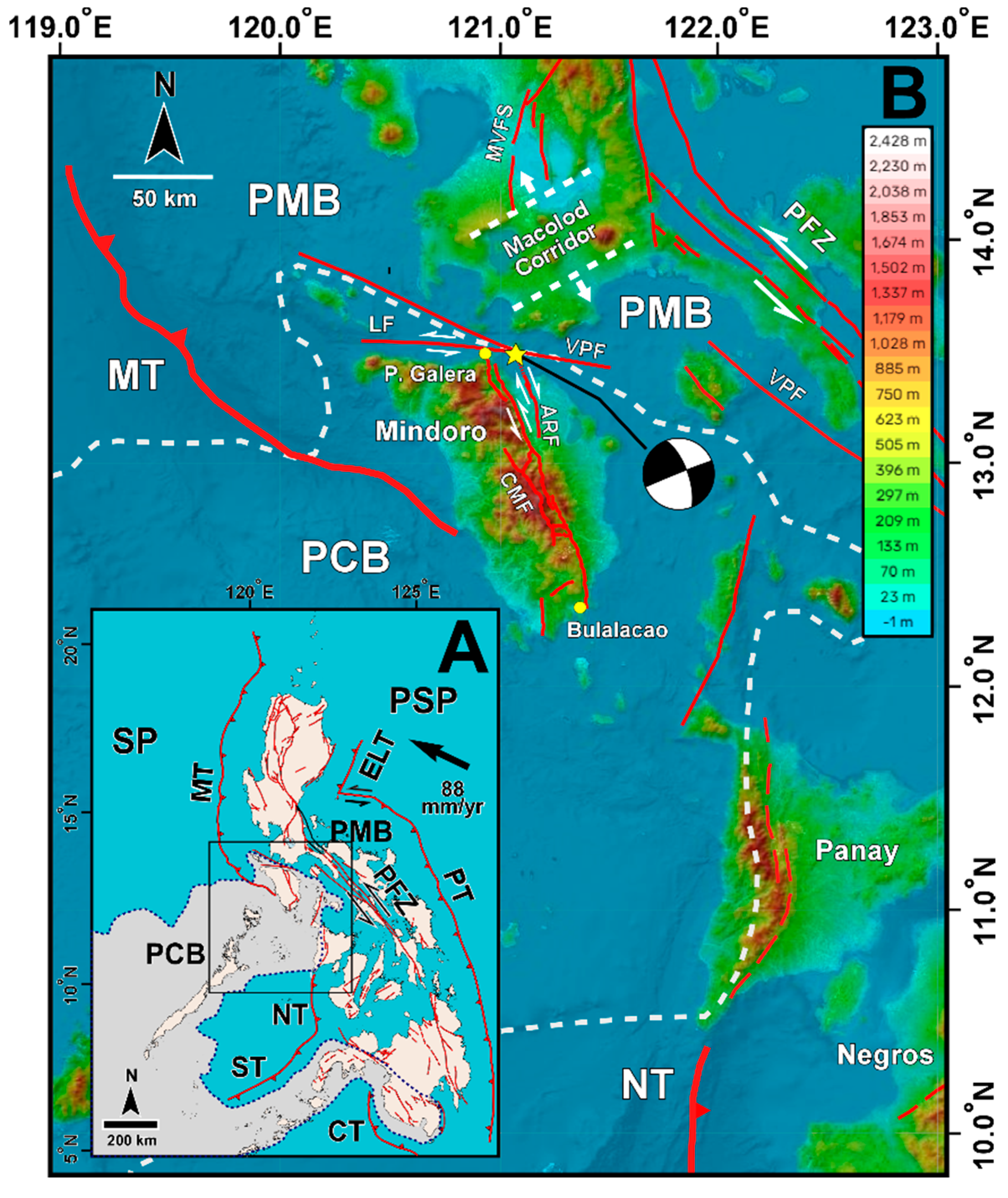
:1. Introduction
2. Materials and Methods
3. Results
4. Discussion
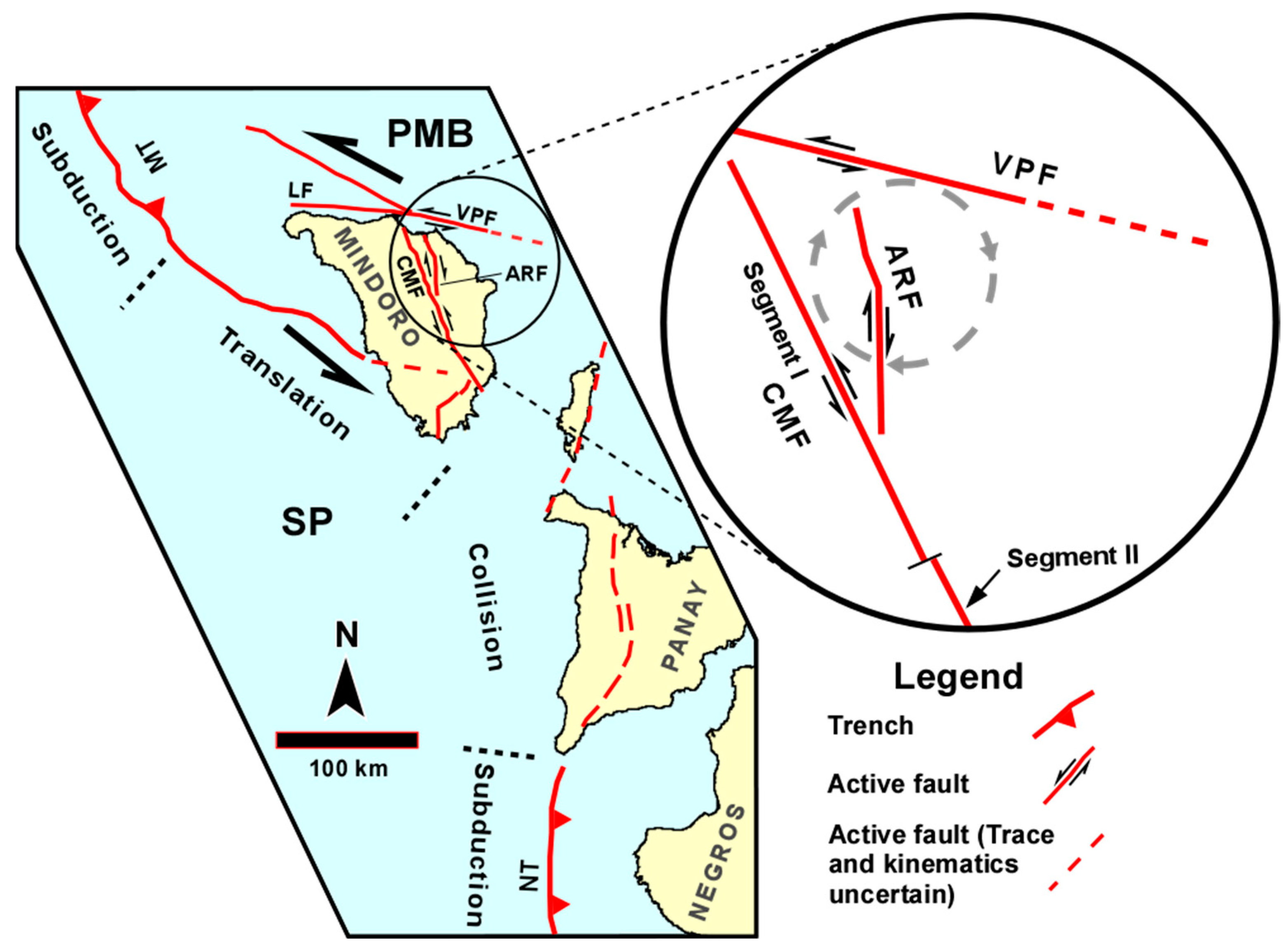
4.1. Along-Trace Variation in Slip and Sense of Motion Along the Central Mindoro Fault
4.2. CMF as a Transcurrent Structure
4.3. Possible Deformation Mechanism(s) Involving Active Faults in the CMF Region

4.4. Hazard Implications
5. Conclusions
Supplementary Materials
Author Contributions
Funding
Data Availability Statement
Acknowledgments
Conflicts of Interest
References
- Karig, D.E. Accreted terranes in the northern part of the Philippine archipelago. Tectonics 1983, 2, 211–236. [Google Scholar] [CrossRef]
- Japan International Cooperation Agency-Metal Mining Agency of Japan. Report on Geological Survey of Mindoro Island: Consolidated Report; Japan International Cooperation Agency: Metro Manila, Philippines, 1984.
- Sarewitz, D.; Karig, D. Processes of allochtonous terrane evolution, Mindoro Island, Philippines. Tectonics 1986, 5, 525–552. [Google Scholar] [CrossRef]
- Karig, D.E.; Sarewitz, D.R.; Haeck, G.D. Role of strike-slip faulting in the evolution of allochthonous terranes in the Philippines. Geology 1986, 14, 852–855. [Google Scholar] [CrossRef]
- Rangin, C.; Stephan, J.F.; Blanchet, R.; Baladad, D.; Bouysee, P.; Chen, M.P.; Chotin, P.; Collot, J.; Daniel, J.; Drouhot, J.M.; et al. Seabeam survey at the southern end of the Manila trench: Transition between subduction and collision processes, offshore Mindoro Island, Philippines. Tectonophysics 1988, 146, 261–278. [Google Scholar] [CrossRef]
- Sarmiento, K.J.S.; Aurelio, M.A.; Flores, P.C.M.; Carrillo, A.D.V.; Marfito, B.J.; Abigania, M.I.T.; Daag, A.S.; Siringan, F.P. Seafloor structures and static stress changes associated with two recent earthquakes in offshore southern Batangas, Philippines. Front. Earth Sci. 2022, 9, 801670. [Google Scholar] [CrossRef]
- Mines and Geosciences Bureau. Geology of the Philippines, 2nd ed.; Mines and Geosciences Bureau: Quezon City, Philippines, 2010.
- Wynne, D.B.; McCabe, R.; Mazzullo, J.; Malicse, A. Terrane suturing, Mindoro, Philippines. In Proceedings of the Abstracts and Programs of the Annual Meeting of the Geological Society of America 1985, Orlando, FL, USA, 28–31 October 1985. [Google Scholar]
- United States Geological Survey. Available online: https://earthquake.usgs.gov/earthquakes/eventpage/usp0006nn2/executive (accessed on 5 December 2024).
- Philippine Institute of Volcanology and Seismology (PHIVOLCS). The PHIVOLCS Faultfinder. Available online: http://faultfinder.phivolcs.dost.gov.ph/ (accessed on 15 May 2023).
- Rimando, R.E.; Rimando, J.M. Morphotectonic Kinematic Indicators along the Vigan-Aggao Fault: The Western Deformation Front of the Philippine Fault Zone in Northern Luzon, the Philippines. Geosciences 2020, 10, 83. [Google Scholar] [CrossRef]
- Hamilton, W.B. Tectonics of the Indonesian region. USA Geol. Surv. Prof. Paper 1979, 1078, 345. [Google Scholar]
- Acharya, H.K.; Aggarwal, Y.P. Seismicity and tectonics of the Philippine Islands. J. Geophys. Res. 1980, 85, 3239–3250. [Google Scholar] [CrossRef]
- Bautista, B.C.B.; Bautista, M.L.P.; Oike, K.; Wu, F.T.; Punongbayan, R.S. A new insight on the geometry of subducting slabs in northern Luzon, Philippines. Tectonophysics 2001, 339, 279–310. [Google Scholar] [CrossRef]
- Cardwell, R.K.; Isacks, B.L.; Karig, D.E. The spatial distribution of earthquakes, focal mechanism solutions and subducted lithosphere in the Philippines and northern Indonesian regions. In The Tectonic and Geologic Evolution of Southeast Asian Seas and Islands (American Geophysical Union Geophysical Monograph), Volume 23; Hayes, D., Ed.; American Geophysical Union: Washington, DC, USA, 1980; pp. 1–35. [Google Scholar]
- Hamburger, M.W.; Cardwell, R.K.; Isacks, B.L. Seismotectonics of the Northern Philippine Island arc. In The Tectonic and Geologic Evolution of Southeastern Asian Seas and Islands, Part 2 (American Geophysical Union Geophysical Monograph), Volume 27; Hayes, D.E., Ed.; American Geophysical Union: Washington, DC, USA, 1983; pp. 1–22. [Google Scholar]
- Hayes, D.E.; Lewis, S.D. Structure and tectonics of the Manila trench system, Western Luzon, Philippines. Energy 1985, 10, 263–279. [Google Scholar] [CrossRef]
- Yumul, G.P.; Dimalanta, C.B.; Tamayo, R.A.; Faustino-Eslava, D.V. Geological features of a collision zone marker: The Antique Ophiolite Complex (Western Panay, Philippines). J. Asian Earth Sci. 2013, 65, 53–63. [Google Scholar] [CrossRef]
- Fitch, T.J. Plate convergence, transcurrent faults, and internal deformation adjacent to Southeast Asia and the western Pacific. J. Geophys. Res. 1972, 77, 4432–4460. [Google Scholar] [CrossRef]
- Barrier, E.; Huchon, P.; Aurelio, M. Philippine Fault: A key for Philippine kinematics. Geology 1991, 19, 32–35. [Google Scholar] [CrossRef]
- Allen, C.R. Circum-Pacific faulting in the Philippines-Taiwan Region. J. Geophys. Res. Space Phys. 1962, 67, 4795–4812. [Google Scholar] [CrossRef]
- Lewis, S.D.; Hayes, D.E. The tectonics of northward propagating subduction along eastern Luzon, Philippine Islands. In The Tectonic and Geologic Evolution of Southeast Asian Seas and Islands, Part 2. Geophysical Monograph Series, Volume 27; Hayes, D.E., Ed.; American Geophysical Union: Washington, DC, USA, 1983; pp. 57–78. [Google Scholar] [CrossRef]
- Foerster, H.; Oles, D.; Knittel, U.; Defant, M.J.; Torres, R.C. The Macolod corridor: A rift crossing the Philippine island arc. Tectonophysics 1990, 183, 265–271. [Google Scholar] [CrossRef]
- Canto, A.P.B.; Padrones, J.T.; Concepcion, R.A.B.; Perez, A.D.C.; Tamayo, R.A., Jr.; Dimalanta, C.B.; Faustino-Eslava, D.V.; Queaño, K.L.; Yumul, G.P., Jr. Geology of northwestern Mindoro and its offshore islands: Implications for terrane accretion in west Central Philippines. J. Asian Earth Sci. 2012, 61, 78–87. [Google Scholar] [CrossRef]
- Gervasio, F.C. Age and nature of orogenesis of the Philippines. Philipp. Geol. Soc. J. 1966, 29, 1–19. [Google Scholar]
- Jones, D.L.; Howell, D.G.; Coney, P.J.; Monger, J. Recognition, character, and analysis of tectonostratigraphic terranes in western North America. In Accretion Tectonics in the Circum-Pacific Region; Hashimoto, M., Uyeda, S., Eds.; Terra Scientific: Tokyo, Japan, 1983; pp. 21–35. [Google Scholar]
- Marchadier, Y.; Rangin, C. Polyphase tectonics at the southern tip of the Manila Trench: Mindoro-Tablas Islands, Philippines. Tectonophysics 1990, 183, 273–287. [Google Scholar] [CrossRef]
- Rangin, C.; Stephan, J.F.; Muller, C. Middle Oligocene oceanic crust of the South China Sea jammed into Mindoro collision zone, Philippines. Geology 1985, 13, 425–428. [Google Scholar] [CrossRef]
- Burtman, V.S. Faults of middle Asia. Am. J. Sci. 1980, 280, 725–744. [Google Scholar] [CrossRef]
- Buwalda, J.P. Shutter ridges, characteristic physiographic features of active faults. Geol. Soc. Am. Proc. 1937, 1936, 307. [Google Scholar]
- Cotton, C.A. Landscape, 2nd ed.Cambridge University Press: Cambridge, UK, 1948; 509p. [Google Scholar]
- Kuchai, V.K.; Trifonov, V.G. A Young Left-Lateral Displacement in the Darvaz-Karakul Fault Zone. Geotectonics 1977, 11, 218–226. [Google Scholar]
- Ransome, F.L. The probable cause of the San Francisco earthquake. Natl. Geogr. Mag. 1906, 17, 280–296. [Google Scholar]
- Russell, R.J. Recent horizontal offsets along the Haywards fault. J. Geol. 1926, 34, 507–511. [Google Scholar] [CrossRef]
- Sieh, K.E.; Jahns, R.H. Holocene activity of the San Andreas fault at Wallace creek, California. Geol. Soc. Am. Bull. 1984, 95, 883–896. [Google Scholar] [CrossRef]
- Sylvester, A.G. Strike-slip faults. Geol. Soc. Am. Bull. 1988, 100, 1666–1703. [Google Scholar] [CrossRef]
- Wallace, R.E. Structure of a portion of the San Andreas rift in southern California. Geol. Soc. Am. Bull. 1949, 60, 781–806. [Google Scholar] [CrossRef]
- Wallace, R.E. Notes on stream channels offset by the San Andreas fault, southern Coast Ranges, California. Stanf. Univ. Publ. Geol. Sci. 1968, 11, 6–21. [Google Scholar]
- Wallace, R.E. The Talas-Fergana Fault, Kirghiz and Kazakh, USSR. Earthq. Inform. Bull. (USGS) 1976, 8, 4–13. [Google Scholar]
- Weiqi, Z.; Decheng, J.; Peizhen, Z.; Molnar, P.; Burchfield, B.C.; Qidong, D.; Fangmin, S. Displacement along the Haiyuan fault associated with the great 1920 Haiyuan, China, earthquake. Bull. Seismol. Soc. Am. 1987, 77, 117–131. [Google Scholar]
- Slemmons, D.B. A procedure for analyzing fault-controlled lineament and active fault. In Proceedings of the 3rd International Conference on Basement Tectonics, Fort Lewis College, Durango, CO, USA, 15–19 May 1978; O’Leary, D.W., Earle, J.L., Eds.; [Google Scholar]
- Crowell, J.C. Origin of Late Cenozoic basins in Southern California. AAPG Bull. 1973, 57, 774. [Google Scholar]
- Dibblee, T.W., Jr. Strike-Slip Tectonics of the San Andreas Fault and Its Role in Cenozoic Basin Evolvement. In Late Mesozoic and Cenozoic Sedimentation and Tectonics in California; Nilsen, T.H., Ed.; San Joaquin Geological Society: Bakersfield, CA, USA, 1977; pp. 26–38. [Google Scholar]
- Sylvester, A.G.; Smith, R.R. Tectonic transpression and basement-controlled deformation in San Andreas fault zone, Salton Trough, California. AAPG Bull. 1976, 60, 2081–2102. [Google Scholar]
- Clark, M.M. Map Showing Recently Active Breaks along the San Andreas Fault and Associated Faults between Salton Sea and Whitewater River-Mission Creek; U. S. Geological Survey: Reston, VA, USA, 1984.
- Davis, T.; Duebendorfer, E. Strip Map of the Western Big Bend Segment of the San Andreas Fault (Map & Chart Series MC-60). Geological Society of America: New York, NY, USA, 1987. [Google Scholar]
- Schubert, C. Neotectonics of a Segment of the San Andreas Fault, Southern California (USA). Eliszeitalter u. Ggw. 1982, 32, 13–22. [Google Scholar] [CrossRef]
- Vedder, J.G.; Wallace, R.E. Map Showing Recently Active Breaks along the San Andreas and Related Faults between Cholame Valley and Tejon Pass; USGS: Reston, VA, USA, 1968. Available online: https://pubs.er.usgs.gov/publication/i574 (accessed on 1 December 2024).
- Nakata, T.; Sangawa, A.; Hirano, S. A report on tectonic landforms along the Philippine fault zone in Northern Luzon, Philippines. Sci. Rep. 1977, 27, 69–93. [Google Scholar]
- Punongbayan, R.S.; Rimando, R.E.; Daligdig, J.A.; Besana, G.M.; Daag, A.S.; Nakata, T.; Tsutsumi, H. Ground rupture of the Luzon earthquake. In Proceedings of the GEOCON ’90—III Annual Geological Convention Proceedings: Special Session on Earthquake Geology and Earthquake Related Hazards, Geological Society of the Philippines, Mandaluyong City, Philippines, 4–7 December 1990. [Google Scholar]
- Rimando, R.E. Neotectonic and paleoseismic study of the Marikina Valley fault system, Philippines. Ph.D. Dissertation, State University of New York at Binghamton, New York, NY, USA, 2002. [Google Scholar]
- Rimando, R.E.; Knuepfer, P.L. Neotectonics of the Marikina Valley fault system (MVFS) and tectonic framework of structures in northern and central Luzon, Philippines. Tectonophysics 2006, 415, 17–38. [Google Scholar] [CrossRef]
- El-Ashmawy, K.L. Investigation of the accuracy of Google Earth elevation data. Artif. Satell. 2016, 51, 89–97. [Google Scholar] [CrossRef]
- Hoffmann, E.; Winde, F. Generating high-resolution digital elevation models for wetland research using Google Earth TM imagery: An example from South Africa. Water SA 2010, 36, 53–68. [Google Scholar]
- Mohammed, N.Z.; Ghazi, A.; Mustafa, H.E. Positional accuracy testing of Google Earth. Int. J. Multidiscip. Sci. Eng. 2013, 4, 6–9. [Google Scholar]
- Sharma, A.; Gupta, D. Derivation of topographic map from elevation data available in Google Earth. Civ. Eng. Urban Plan. Int. J. (CiVEJ) 2014, 1, 14–21. [Google Scholar] [CrossRef]
- Wallace, R.E. Discussion-nomograms for estimating components of fault displacement from measured height of fault scarp. Bull. Ass. Engin. Geol. 1980, 17, 39–45. [Google Scholar] [CrossRef]
- Caskey, S.J. Geometric relations of dip slip to a faulted ground surface: New nomograms for estimating components of fault displacement. J. Struct. Geol. 1995, 17, 1197–1202. [Google Scholar] [CrossRef]
- Costa, C.H.; Cesco, J.C.; Moran, R.J. A simple graphical method for estimating the components of the fault-slip vector. J. Struc. Geol. 1997, 19, 1245–1247. [Google Scholar] [CrossRef]
- Knuepfer, P.L.K. Implications of the characteristics of end-points of historical surface fault ruptures for the nature of fault segmentation. Fault Segmentation Control. Rupture Initiat. Termin. 1989, 89, 193–228. [Google Scholar]
- DePolo, C.M.; Clark, D.G.; Slemmons, D.B.; Ramelli, A.R. Historical surface faulting in the Basin and Range province, western North America: Implications for fault segmentation. J. Struct. Geol. 1991, 13, 123–136. [Google Scholar] [CrossRef]
- Angelier, J. Fault slip analysis and paleostress reconstruction. In Continental Deformation; Hancock, P., Ed.; Pergamon: Oxford, UK, 1994; pp. 53–100. [Google Scholar]
- Chen, P.F.; Olavere, E.A.; Wang, C.W.; Bautista, B.C.; Solidum, R.U.; Liang, W.T. Seismotectonics of Mindoro, Philippines. Tectonophysics 2015, 640–641, 70–79. [Google Scholar] [CrossRef]
- Pubellier, M.; Quebral, R.; Aurelio, M.; Rangin, C. Docking and postdocking escape tectonics in the southern Philippines. Geol. Soc. Lond. Spec. Publ. 1997, 106, 511–523. [Google Scholar] [CrossRef]
- Bischke, R.E.; Suppe, J.; del Pilar, R. A new branch of the Philippine fault system as observed from aeromagnetic and seismic data. Tectonophysics 1990, 183, 243–264. [Google Scholar] [CrossRef]
- Pubellier, M.; Garcia, F.; Loevenbruck, A.; Chorowicz, J. Recent Deformation at the junction between the North Luzon Block and the Central Philippines from ERS-1 Images. Isl. Arc. 2000, 9, 598–610. [Google Scholar] [CrossRef]
- Rimando, R.E.; Punongbayan, R.S.; Geronimo-Catane, S.G.; Mirabueno, H.S.; Rasdas, A.S. Ground rupture of the 15 November 1994 Oriental Mindoro (Philippines) earthquake. In Proceedings of the Abstracts of the XXI General Assembly of IUGG, Boulder, CO, USA, 2–14 July 1995. [Google Scholar]
- Wells, D.L.; Coppersmith, K.J. New empirical relationships among magnitude, rupture length, rupture width, rupture area, and surface displacement. Bull. Seismol. Soc. Am. 1994, 84, 974–1002. [Google Scholar] [CrossRef]
- Ron, H.; Freund, R.; Garfunkel, Z.; Nur, A. Block rotation by strike-slip faulting: Structural and paleomagnetic evidence. J. Geophys. Res. Solid Earth 1984, 89, 6256–6270. [Google Scholar] [CrossRef]
- Garfunkel, Z.; Ron, H. Block rotation and deformation by strike slip fault 2. The properties of a type of macroscopic discontinuous deformation. J. Geophys. Res. 1985, 90, 8589–8602. [Google Scholar] [CrossRef]
- Ron, H.; Aydin, A.; Nur, A. Strike-slip faulting and block rotation in the Lake Mead Fault System. Geology 1986, 14, 1020–1023. [Google Scholar] [CrossRef]
- Philippine Institute of Volcanology and Seismology (PHIVOLCS) (2023b). Special Report No. 2: 15 November 1994 Mindoro Earthquake: Preliminary Report of Investigation. Available online: https://www.phivolcs.dost.gov.ph/index.php/earthquake/destructive-earthquake-of-the-philippines/ (accessed on 15 May 2023).


| Segment | Segment Type | Length (km) | V/H | Sense of Horizontal Displacement | |
|---|---|---|---|---|---|
| Mean | Max | ||||
| IA | Major segment | 80.25 | 0.28 | 0.89 | All 94 measurement sites indicate sinistral sense of horizontal displacement |
| IB | Minor segment; adjacent and subparallel to IA | 25.6 | 0.23 | 0.36 | All 16 measurement sites indicate sinistral sense of horizontal displacement |
| II | Major segment | 60.4 | 0.17 | 0.46 | All 74 measurement sites indicate sinistral sense of horizontal displacement |
| IIIA | Major segment | 57 | 0.23 | 0.58 | All 57 measurement sites indicate sinistral sense of horizontal displacement |
| IIIB | Minor segment; occurs within gap between II and IIA | 8.1 | 0.41 | 0.66 | 13 measurement sites indicate sinistral sense of horizontal displacement; 3 measurement sites indicate dextral sense of horizontal displacement |
| IIIC | Minor segment; occurs within gap between II and IIA | 7.2 | 0.45 | 1.0 | All 9 measurement sites indicate sinistral sense of horizontal displacement |
| IIID | Minor segment; occurs within gap between IA and IIIA | 12.4 | 0.37 | 0.84 | All 16 measurement sites indicate sinistral sense of horizontal displacement |
| IIIE | Minor segment; adjacent and subparallel to IIIA | 5.9 | 0.37 | 0.72 | All 9 measurement sites indicate sinistral sense of displacement |
Disclaimer/Publisher’s Note: The statements, opinions and data contained in all publications are solely those of the individual author(s) and contributor(s) and not of MDPI and/or the editor(s). MDPI and/or the editor(s) disclaim responsibility for any injury to people or property resulting from any ideas, methods, instructions or products referred to in the content. |
© 2025 by the authors. Licensee MDPI, Basel, Switzerland. This article is an open access article distributed under the terms and conditions of the Creative Commons Attribution (CC BY) license (https://creativecommons.org/licenses/by/4.0/).
Share and Cite
Rimando, R.; Rimando, J. The Central Mindoro Fault: An Active Sinistral Fault Within the Translational Boundary Between the Palawan Microcontinental Block and the Philippine Mobile Belt. GeoHazards 2025, 6, 6. https://doi.org/10.3390/geohazards6010006
Rimando R, Rimando J. The Central Mindoro Fault: An Active Sinistral Fault Within the Translational Boundary Between the Palawan Microcontinental Block and the Philippine Mobile Belt. GeoHazards. 2025; 6(1):6. https://doi.org/10.3390/geohazards6010006
Chicago/Turabian StyleRimando, Rolly, and Jeremy Rimando. 2025. "The Central Mindoro Fault: An Active Sinistral Fault Within the Translational Boundary Between the Palawan Microcontinental Block and the Philippine Mobile Belt" GeoHazards 6, no. 1: 6. https://doi.org/10.3390/geohazards6010006
APA StyleRimando, R., & Rimando, J. (2025). The Central Mindoro Fault: An Active Sinistral Fault Within the Translational Boundary Between the Palawan Microcontinental Block and the Philippine Mobile Belt. GeoHazards, 6(1), 6. https://doi.org/10.3390/geohazards6010006