The Use of an Unmanned Aerial Vehicle (UAV) for First-Failure Landslide Detection
Abstract
1. Introduction
2. Materials and Methods
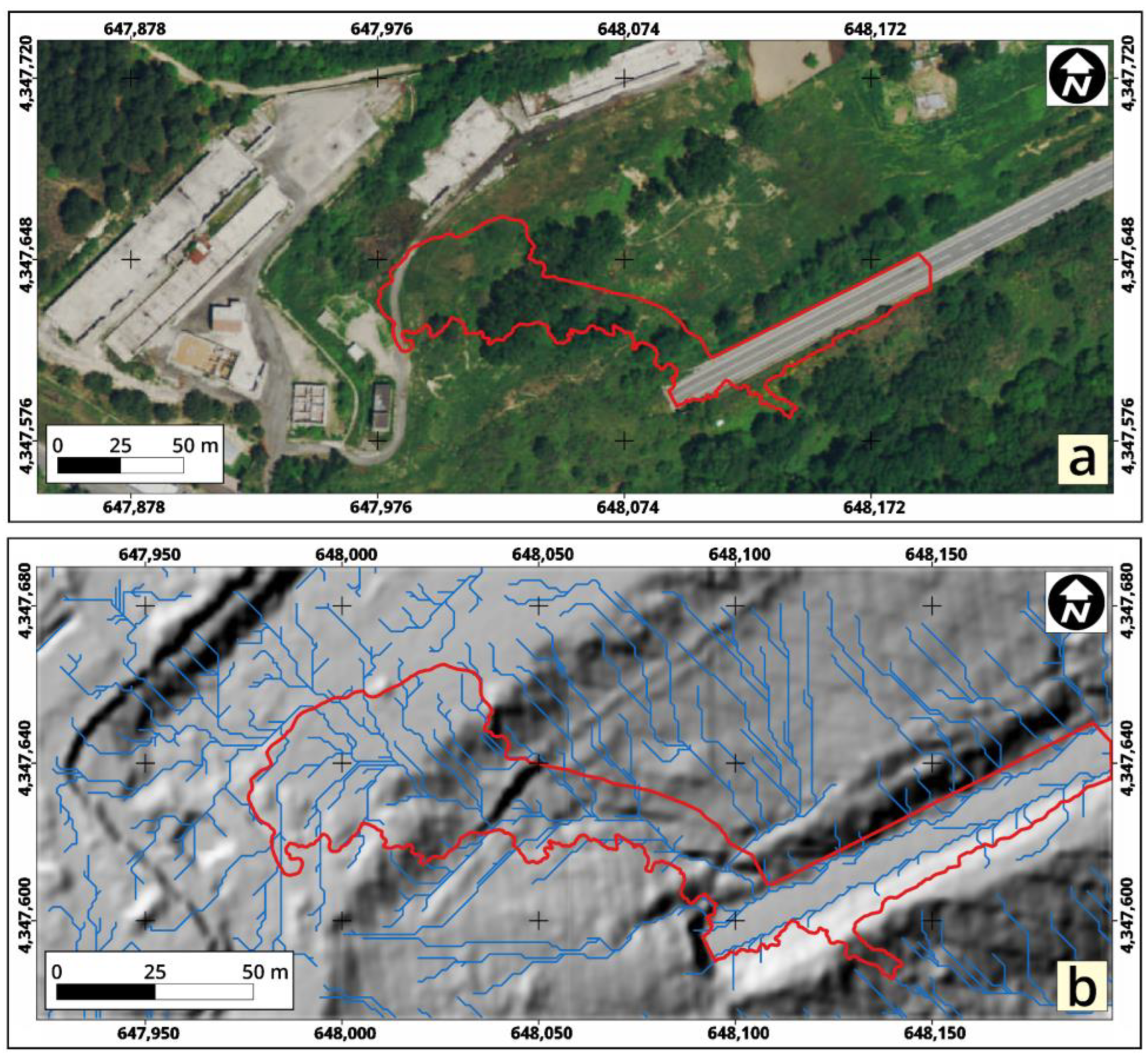
2.1. Study Area and Landslide Event
2.2. Data Acquisition and Elaboration
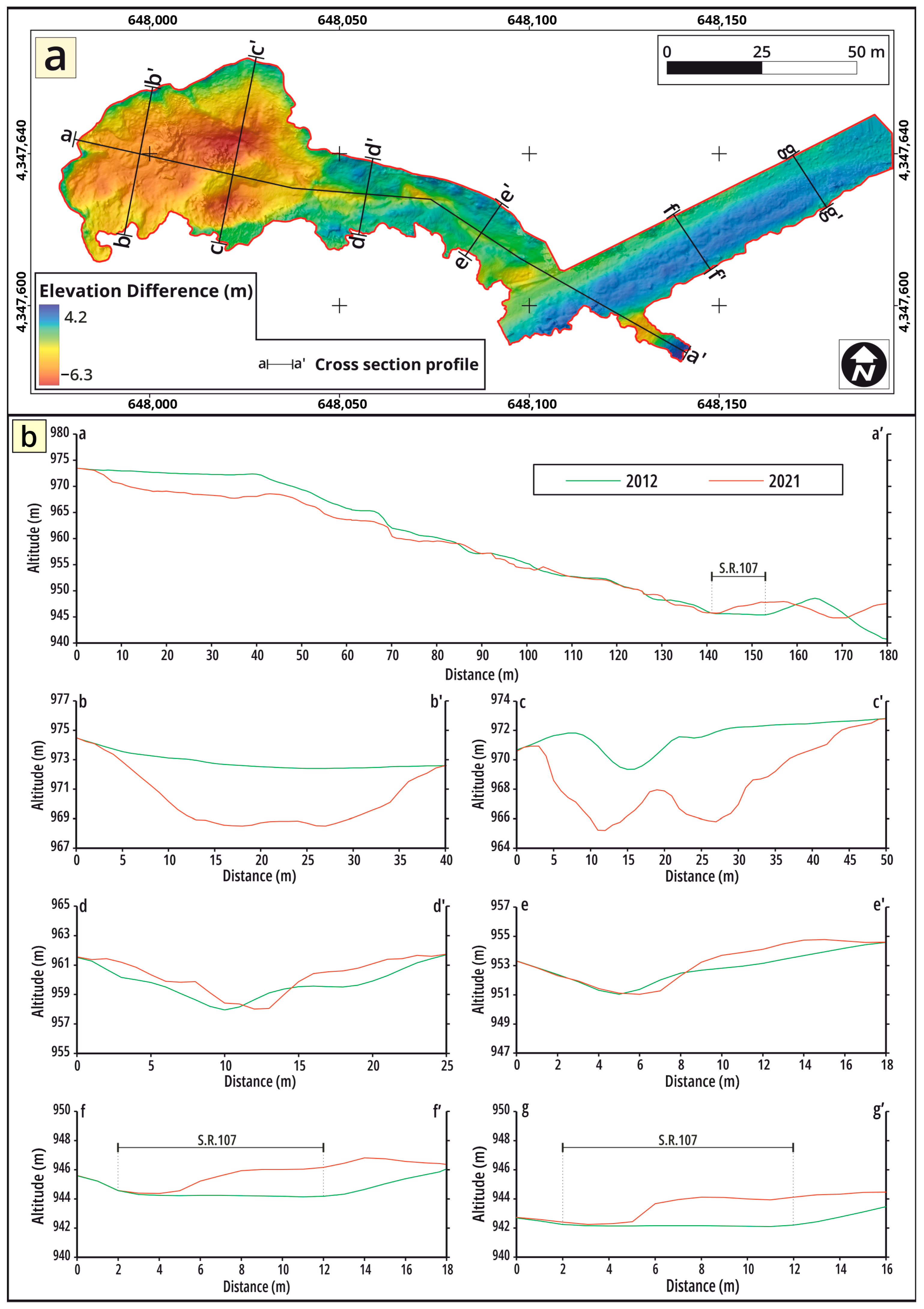
3. Results
4. Discussion and Conclusions
Author Contributions
Funding
Data Availability Statement
Conflicts of Interest
References
- Petrucci, O. Landslide Fatality Occurrence: A Systematic Review of Research Published between January 2010 and March 2022. Sustainability 2022, 14, 9346. [Google Scholar] [CrossRef]
- Bathrellos, G.D.; Koukouvelas, I.K.; Skilodimou, H.D.; Nikolakopoulos, K.G.; Vgenopoulos, A.-L. Landslide causative factors evaluation using GIS in the tectonically active Glafkos River area, northwestern Peloponnese, Greece. Geomorphology 2024, 461, 109285. [Google Scholar] [CrossRef]
- Calista, M.; Miccadei, E.; Piacentini, T.; Sciarra, N. Morphostructural, Meteorological and Seismic Factors Controlling Landslides in Weak Rocks: The Case Studies of Castelnuovo and Ponzano (North East Abruzzo, Central Italy). Geosciences 2019, 9, 122. [Google Scholar] [CrossRef]
- Zou, Y.; Qi, S.; Guo, S.; Zheng, B.; Zhan, Z.; He, N.; Huang, X.; Hou, X.; Liu, H. Factors controlling the spatial distribution of coseismic landslides triggered by the Mw 6.1 Ludian earthquake in China. Eng. Geol. 2022, 296, 106477. [Google Scholar] [CrossRef]
- Mogili, U.R.; Deepak, B.B.V.L. Review on Application of Drone Systems in Precision Agriculture. Procedia Comput. Sci. 2018, 133, 502–509. [Google Scholar] [CrossRef]
- Istiak, M.A.; Syeed, M.M.M.; Hossain, M.S.; Uddin, M.F.; Hasan, M.; Khan, R.H.; Azad, N.S. Adoption of Unmanned Aerial Vehicle (UAV) Imagery in Agricultural Management: A Systematic Literature Review. Ecol. Inf. 2023, 78, 102305. [Google Scholar] [CrossRef]
- AlAli, Z.T.; Alabady, S.A. The Role of Unmanned Aerial Vehicle and Related Technologies in Disasters. Remote Sens. Appl. 2022, 28, 100873. [Google Scholar] [CrossRef]
- Rohman, B.P.A.; Andra, M.B.; Putra, H.F.; Fandiantoro, D.H.; Nishimoto, M. Multisensory Surveillance Drone for Survivor Detection and Geolocalization in Complex Post-Disaster Environment. In Proceedings of the IGARSS 2019—2019 IEEE International Geoscience and Remote Sensing Symposium, Yokohama, Japan, 28 July–2 August 2019; pp. 9368–9371. [Google Scholar]
- Martinez-Alpiste, I.; Golcarenarenji, G.; Wang, Q.; Alcaraz-Calero, J.M. Search and Rescue Operation Using UAVs: A Case Study. Expert. Syst. Appl. 2021, 178, 114937. [Google Scholar] [CrossRef]
- Gomez, C.; Purdie, H. UAV-Based Photogrammetry and Geocomputing for Hazards and Disaster Risk Monitoring—A Review. Geoenviron. Disasters 2016, 3, 23. [Google Scholar] [CrossRef]
- Borrelli, L.; Conforti, M.; Mercuri, M. Lidar and UAV System Data to Analyse Recent Morphological Changes of a Small Drainage Basin. ISPRS Int. J. Geoinf. 2019, 8, 536. [Google Scholar] [CrossRef]
- Fell, R.; Ho, K.K.S.; Lacasse, S.; Leroi, E. A Framework for Landslide Risk Assessment and Management. In Landslide Risk Management; Hungr, O., Fell, R., Couture, R., Eberhardt, E., Eds.; Taylor and Francis: London, UK, 2005; pp. 3–26. [Google Scholar]
- Conforti, M.; Mercuri, M.; Borrelli, L. Morphological Changes Detection of a Large Earthflow Using Archived Images, LiDAR-Derived DTM, and UAV-Based Remote Sensing. Remote Sens. 2021, 13, 120. [Google Scholar] [CrossRef]
- Guo, Z.; Chen, L.; Yin, K.; Shrestha, D.P.; Zhang, L. Quantitative risk assessment of slow-moving landslides from the viewpoint of decision-making: A case study of the Three Gorges Reservoir in China. Eng. Geol. 2020, 273, 105667. [Google Scholar] [CrossRef]
- França Pereira, F.; Sussel Gonçalves Mendes, T.; Jorge Coelho Simões, S.; Magalhães de Andrade, M.R.; Lopes Reiss, M.L.; Cavalcante Renk, J.F.; da Silva Santos, T.C. Comparison of LiDAR- and UAV-derived data for landslide susceptibility mapping using Random Forest algorithm. Landslides 2023, 20, 579–600. [Google Scholar] [CrossRef]
- Mercuri, M.; Conforti, M.; Ciurleo, M.; Borrelli, L. UAV Application for Short-Time Evolution Detection of the Vomice Landslide (South Italy). Geosciences 2023, 13, 29. [Google Scholar] [CrossRef]
- Rossi, G.; Tanteri, L.; Tofani, V.; Vannocci, P.; Moretti, S.; Casagli, N. Multitemporal UAV Surveys for Landslide Mapping and Characterization. Landslides 2018, 15, 1045–1052. [Google Scholar] [CrossRef]
- Garnica-Peña, R.J.; Alcántara-Ayala, I. The Use of UAVs for Landslide Disaster Risk Research and Disaster Risk Management: A Literature Review. J. Mt. Sci. 2021, 18, 482–498. [Google Scholar] [CrossRef]
- Giordan, D.; Hayakawa, Y.; Nex, F.; Remondino, F.; Tarolli, P. Review Article: The Use of Remotely Piloted Aircraft Systems (RPASs) for Natural Hazards Monitoring and Management. Nat. Hazards Earth Syst. Sci. 2018, 18, 1079–1096. [Google Scholar] [CrossRef]
- Sun, J.; Yuan, G.; Song, L.; Zhang, H. Unmanned Aerial Vehicles (UAVs) in Landslide Investigation and Monitoring: A Review. Drones 2024, 8, 30. [Google Scholar] [CrossRef]
- Godone, D.; Allasia, P.; Borrelli, L.; Gullà, G. UAV and Structure from Motion Approach to Monitor the Maierato Landslide Evolution. Remote Sens. 2020, 12, 1039. [Google Scholar] [CrossRef]
- Zárate, B.A.; El Hamdouni, R.; Fernández del Castillo, T. Characterization and Analysis of Landslide Evolution in Intramountain Areas in Loja (Ecuador) Using RPAS Photogrammetric Products. Remote Sens. 2023, 15, 3860. [Google Scholar] [CrossRef]
- Al-Rawabdeh, A.; He, F.; Moussa, A.; El-Sheimy, N.; Habib, A. Using an Unmanned Aerial Vehicle-Based Digital Imaging System to Derive a 3D Point Cloud for Landslide Scarp Recognition. Remote Sens. 2016, 8, 95. [Google Scholar] [CrossRef]
- Giordan, D.; Allasia, P.; Manconi, A.; Baldo, M.; Santangelo, M.; Cardinali, M.; Corazza, A.; Albanese, V.; Lollino, G.; Guzzetti, F. Morphological and Kinematic Evolution of a Large Earthflow: The Montaguto Landslide, Southern Italy. Geomorphology 2013, 187, 61–79. [Google Scholar] [CrossRef]
- Ciurleo, M.; Ferlisi, S.; Foresta, V.; Mandaglio, M.C.; Moraci, N. Landslide Susceptibility Analysis by Applying TRIGRS to a Reliable Geotechnical Slope Model. Geosciences 2021, 12, 18. [Google Scholar] [CrossRef]
- Yordanov, V.; Truong, Q.X.; Brovelli, M.A. Estimating Landslide Surface Displacement by Combining Low-Cost UAV Setup, Topographic Visualization and Computer Vision Techniques. Drones 2023, 7, 85. [Google Scholar] [CrossRef]
- Chang, K.-J.; Tseng, C.-W.; Tseng, C.-M.; Liao, T.-C.; Yang, C.-J. Application of Unmanned Aerial Vehicle (UAV)-Acquired Topography for Quantifying Typhoon-Driven Landslide Volume and Its Potential Topographic Impact on Rivers in Mountainous Catchments. Appl. Sci. 2020, 10, 6102. [Google Scholar] [CrossRef]
- Alawad, W.; Ben Halima, N.; Aziz, L. An Unmanned Aerial Vehicle (UAV) System for Disaster and Crisis Management in Smart Cities. Electronics 2023, 12, 1051. [Google Scholar] [CrossRef]
- Erdelj, M.; Natalizio, E. UAV-Assisted Disaster Management: Applications and Open Issues. In Proceedings of the 2016 International Conference on Computing, Networking and Communications (ICNC), Kauai, HI, USA, 15–18 February 2016; pp. 1–5. [Google Scholar]
- Bashyam, A.; Guggenheim, J.W. UAVs for Wilderness Search and Rescue: Real-World Considerations and Technology Roadmap for Fixed Wing UAVs. J. Search Rescue 2019, 3, 1–18. [Google Scholar] [CrossRef]
- Losnegård, S. Europe’s Largest Drone Operation after Deadly Landslide in Norway. 420 Missions and 200 Hours of Airtime. Available online: https://www.uasnorway.no/europes-largest-drone-operation-after-deadly-landslide-in-norway-420 (accessed on 1 July 2024).
- Borrelli, L.; Coniglio, S.; Critelli, S.; La Barbera, A.; Gullà, G. Weathering Grade in Granitoid Rocks: The San Giovanni in Fiore Area (Calabria, Italy). J. Maps 2016, 12, 260–275. [Google Scholar] [CrossRef]
- Turner, D.; Lucieer, A.; de Jong, S. Time Series Analysis of Landslide Dynamics Using an Unmanned Aerial Vehicle (UAV). Remote Sens. 2015, 7, 1736–1757. [Google Scholar] [CrossRef]
- Immerzeel, W.W.; Kraaijenbrink, P.D.A.; Shea, J.M.; Shrestha, A.B.; Pellicciotti, F.; Bierkens, M.F.P.; de Jong, S.M. High-Resolution Monitoring of Himalayan Glacier Dynamics Using Unmanned Aerial Vehicles. Remote Sens. Environ. 2014, 150, 93–103. [Google Scholar] [CrossRef]
- Lucieer, A.; de Jong, S.M.; Turner, D. Mapping Landslide Displacements Using Structure from Motion (SfM) and Image Correlation of Multi-Temporal UAV Photography. Prog. Phys. Geogr. Earth Environ. 2014, 38, 97–116. [Google Scholar] [CrossRef]
- Rippin, D.M.; Pomfret, A.; King, N. High Resolution Mapping of Supra-Glacial Drainage Pathways Reveals Link between Micro-Channel Drainage Density, Surface Roughness and Surface Reflectance. Earth Surf. Process Landf. 2015, 40, 1279–1290. [Google Scholar] [CrossRef]
- Tarolli, P. High-Resolution Topography for Understanding Earth Surface Processes: Opportunities and Challenges. Geomorphology 2014, 216, 295–312. [Google Scholar] [CrossRef]
- Pellicani, R.; Argentiero, I.; Manzari, P.; Spilotro, G.; Marzo, C.; Ermini, R.; Apollonio, C. UAV and Airborne LiDAR Data for Interpreting Kinematic Evolution of Landslide Movements: The Case Study of the Montescaglioso Landslide (Southern Italy). Geosciences 2019, 9, 248. [Google Scholar] [CrossRef]
- Ullman, S. Computational Studies in the Interpretation of Structure and Motion: Summary and Extension. Mass. Inst. Technol. AI Memo 1983, 706, 1–25. [Google Scholar]
- Giordan, D.; Adams, M.S.; Aicardi, I.; Alicandro, M.; Allasia, P.; Baldo, M.; De Berardinis, P.; Dominici, D.; Godone, D.; Hobbs, P.; et al. The Use of Unmanned Aerial Vehicles (UAVs) for Engineering Geology Applications. Bull. Eng. Geol. Environ. 2020, 79, 3437–3481. [Google Scholar] [CrossRef]
- Massaro, L.; Forte, G.; De Falco, M.; Rauseo, F.; Santo, A. Rockfall source identification and trajectory analysis from UAV-based data in volcano-tectonic areas: A case study from Ischia Island, Southern Italy. Bull. Eng. Geol. Environ. 2024, 83, 75. [Google Scholar] [CrossRef]
- Choi, S.K.; Ramirez, R.A.; Lim, H.H.; Kwon, T.H. Multi-source remote sensing-based landslide investigation: The case of the August 7, 2020, Gokseong landslide in South Korea. Sci. Rep. 2024, 14, 12048. [Google Scholar] [CrossRef]
- Zhang, W.; Zhao, X.; Pan, X.; Wei, M.; Yan, J.; Chen, J. Characterization of high and steep slopes and 3D rockfall statistical kinematic analysis for Kangyuqu area, China. Eng. Geol. 2022, 308, 106807. [Google Scholar] [CrossRef]
- De Falco, M.; Forte, G.; Marino, E.; Massaro, L.; Santo, A. UAV and field survey observations on the November 26th 2022 Celario flowslide, Ischia Island (Southern Italy). J. Maps 2023, 19, 2261484. [Google Scholar] [CrossRef]
- Devoto, S.; Macovaz, V.; Mantovani, M.; Soldati, M.; Furlani, S. Advantages of Using UAV Digital Photogrammetry in the Study of Slow-Moving Coastal Landslides. Remote Sens. 2020, 12, 3566. [Google Scholar] [CrossRef]
- Johnson, S.E.; Haneberg, W.C.; Bryson, L.S.; Crawford, M.M. Measuring ground surface elevation changes in a slow-moving colluvial landslide using combinations of regional airborne lidar, UAV lidar and UAV photogrammetric surveys. Q. J. Eng. Geol. Hydrogeol. 2023, 56, qjegh2022-078. [Google Scholar] [CrossRef]
- Cruden, D.M.; Varnes, D.J. Landslides: Investigation and Mitigation. Chapter 3—Landslide Types and Processes. Transp. Res. Board. Spec. Rep. 1996, 247, 36–75. [Google Scholar]
- Gullà, G.; Conforti, M.; Borrelli, L. A Refinement Analysis of the Shallow Landslides Susceptibility at Regional Scale Supported by GIS-Aided Geo-Database. Geomat. Nat. Hazards Risk 2021, 12, 2500–2543. [Google Scholar] [CrossRef]
- Gullà, G.; Peduto, D.; Borrelli, L.; Antronico, L.; Fornaro, G. Geometric and Kinematic Characterization of Landslides Affecting Urban Areas: The Lungro Case Study (Calabria, Southern Italy). Landslides 2017, 14, 171–188. [Google Scholar] [CrossRef]




| UAV Survey | |
|---|---|
| Acquisition data | 28 October 2021 |
| Flight duration (minutes) | 19:00 |
| Frontal overlap (%) | 90 |
| Side overlap (%) | 85 |
| Number of images | 188 |
| Average flight altitude (m) | 50 |
| Average GSD (cm/pix) | 2.7 |
| Coverage area (ha) | 4.5 |
| Number of ground control points (GCPs) | 7 |
| Number of check points (CHKs) | 4 |
| UAV Survey | |
|---|---|
| X RMSE (m) | 0.048 |
| Y RMSE (m) | 0.051 |
| Z RMSE (m) | 0.058 |
| Orthomosaic resolution (m/pix) | 0.2 |
| DSM resolution (m/pix) | 0.3 |
| DTM resolution (m/pix) | 0.5 |
Disclaimer/Publisher’s Note: The statements, opinions and data contained in all publications are solely those of the individual author(s) and contributor(s) and not of MDPI and/or the editor(s). MDPI and/or the editor(s) disclaim responsibility for any injury to people or property resulting from any ideas, methods, instructions or products referred to in the content. |
© 2024 by the authors. Licensee MDPI, Basel, Switzerland. This article is an open access article distributed under the terms and conditions of the Creative Commons Attribution (CC BY) license (https://creativecommons.org/licenses/by/4.0/).
Share and Cite
Mercuri, M.; Biondino, D.; Ciurleo, M.; Cofone, G.; Conforti, M.; Gullà, G.; Stellato, M.C.; Borrelli, L. The Use of an Unmanned Aerial Vehicle (UAV) for First-Failure Landslide Detection. GeoHazards 2024, 5, 683-699. https://doi.org/10.3390/geohazards5030035
Mercuri M, Biondino D, Ciurleo M, Cofone G, Conforti M, Gullà G, Stellato MC, Borrelli L. The Use of an Unmanned Aerial Vehicle (UAV) for First-Failure Landslide Detection. GeoHazards. 2024; 5(3):683-699. https://doi.org/10.3390/geohazards5030035
Chicago/Turabian StyleMercuri, Michele, Deborah Biondino, Mariantonietta Ciurleo, Gino Cofone, Massimo Conforti, Giovanni Gullà, Maria Carmela Stellato, and Luigi Borrelli. 2024. "The Use of an Unmanned Aerial Vehicle (UAV) for First-Failure Landslide Detection" GeoHazards 5, no. 3: 683-699. https://doi.org/10.3390/geohazards5030035
APA StyleMercuri, M., Biondino, D., Ciurleo, M., Cofone, G., Conforti, M., Gullà, G., Stellato, M. C., & Borrelli, L. (2024). The Use of an Unmanned Aerial Vehicle (UAV) for First-Failure Landslide Detection. GeoHazards, 5(3), 683-699. https://doi.org/10.3390/geohazards5030035


