Article

Morphotectonic Structures along the Southwestern Margin of Lesvos Island, and Their Interrelation with the Southern Strand of the North Anatolian Fault, Aegean Sea, Greece

1
Department of Geology and Geoenvironment, National and Kapodistrian University of Athens, Panepistimioupoli Zografou, 15784 Athens, Greece
2
Hellenic Navy Hydrographic Service, Mesogeion 229, TGN 1040, 15661 Athens, Greece
*
Author to whom correspondence should be addressed.
GeoHazards 2021, 2(4), 415-429; https://doi.org/10.3390/geohazards2040023
Submission received: 1 November 2021 / Revised: 4 December 2021 / Accepted: 10 December 2021 / Published: 14 December 2021

Abstract

:
A hydrographic survey of the southwestern coastal margin of Lesvos Island (Greece) was conducted by the Naftilos vessel of the Hellenic Hydrographic Service. The results have been included in a bathymetric map and morphological slope map of the area. Based on the neotectonic and seismotectonic data of the broader area, a morphotectonic map of Lesvos Island has been compiled. The main feature is the basin sub-parallel to the coast elongated Lesvos Basin, 45 km long, 10–35 km wide, and 700 m deep. The northern margin of the basin is abrupt, with morphological slopes towards the south between 35° and 45° corresponding to a WNW-ESE normal fault, in contrast with the southern margin that shows a gradual slope increase from 1° to 5° towards the north. Thus, the main Lesvos Basin represents a half-graben structure. The geometry of the main basin is interrupted at its eastern segment by an oblique NW-SE narrow channel of 650 m depth and 8 km length. East of the channel, the main basin continues as a shallow Eastern Basin. At the western part of the Lesvos margin, the shallow Western Basin forms an asymmetric tectonic graben. Thus, the Lesvos southern margin is segmented in three basins with different morphotectonic characteristics. At the northwestern margin of Lesvos, three shallow basins of 300–400 m depth are observed with WNW-ESE trending high slope margins, probably controlled by normal faults. Shallow water marine terraces representing the last low stands of the glacial periods are observed at 140 m and 200 m depth at the two edges of the Lesvos margin. A secondary E-W fault disrupts the two terraces at the eastern part of the southern Lesvos margin. The NE-SW strike-slip fault zone of Kalloni-Aghia Paraskevi, activated in 1867, borders the west of the Lesvos Basin from the shallow Western Basin. The Lesvos bathymetric data were combined with those of the eastern Skyros Basin, representing the southern strand of the North Anatolian Fault in the North Aegean Sea, and the resulted tectonic map indicates that the three Lesvos western basins are pull-aparts of the strike-slip fault zone between the Skyros Fault and the Adramytion (Edremit) Fault. The seismic activity since 2017 has shown the co-existence of normal faulting and strike-slip faulting throughout the 90 km long Lesvos southern margin.

1. Introduction

Lesvos Island is located at the Eastern Aegean Sea near the coast with Minor Asia south of the southern strand of the North Anatolian Fault zone, forming the Skyros Basin (Figure 1). Its geodetic annual rate is 30 mm/year to the west-southwest, and the strain rate is dominated by NNE-SSW extension with minor WNW-ESE compression resulting in transtensional tectonics [1,2,3,4,5,6]. Focal mechanisms indicate dextral NE-SW strike-slip faults and WNW-ESE normal faults [7,8,9]. From a tectonic point of view, Lesvos lies along the eastern margin of the Aegean microplate and the West Anatolian Shear Zone (WASZ), which separates the Aegean from the Anatolian micro-plate [10] (Figure 1, inset map).
The geology of Lesvos comprises metamorphic rocks and ophiolites belonging to two different tectono-stratigraphic terranes [11,12], largely corresponding to the two tectonic units distinguished earlier [13,14]. The basal unit belonging to a Permo-triassic metamorphosed carbonate platform crops out at Mytilini and Olympus mt., whereas the ophiolites and associated metamorphic rocks form a tectonic nappe surrounding the tectonic window of Olympus. The northwestern part of Lesvos is separated from the southeastern part by the Kalloni Gulf and is almost entirely covered by Lower Miocene volcanic rocks (ages between 20–16 Ma, [15]). The area’s active tectonics is shown by the morphotectonic structures onshore and offshore Lesvos Island and the regional seismicity. Seismic activity has been known since ancient times and continues until today [16,17,18,19]. Seismic events in the past have produced extended damages, mainly in the central part of the Island. These events include the 1867 magnitude 7.0 earthquake along the Aghia Paraskevi—Kalloni dextral strike-slip fault zone as well as along the coastal zone, especially along the southeastern part in the area of Vatera-Plomari [20,21]. More recently, the June 2017 event showed a magnitude 6.3 main shock, whose focal mechanism indicated a WNW-ESE oriented normal fault, dipping 45° to the SSE, running parallel to the southeast segment of the WNW-ESE oriented Lesvos coastline [22,23,24,25]. Two major aftershocks of magnitudes 5.2 and 5.0 occurred on two NW-SE sub-vertical faults, whose focal mechanisms indicated strike-slip motion [22,24] bordering a narrow deep channel [25]. The neotectonic deformation can be analyzed on the basis of morphotectonic data both onshore and offshore. Onshore Lesvos, the analysis is based on the distribution of characteristic Neogene geological formations overlying the alpine basement, such as the top stratigraphic volcano-sedimentary formation of the Miocene Lesvos Ignimbrite, the Pliocene lacustrine sedimentary formations, and the marine Pleistocene sediments, occurring along the Vatera coastal area [13]. Especially along the Vatera coastal zone, a considerable tectonic uplift has brought the marine Pleistocene sediments to the surface during Late Pleistocene-Holocene, with a characteristic back-tilt of their bedding towards the NE, against a normal fault of NW-SE direction, separating the sediments from the footwall, where the Alpine ophiolitic basement and overlying Miocene Ignimbrite crop out.
Recently, Nomikou et al. [25] presented the active tectonic structures of the Lesvos Basin at the eastern part of the Lesvos margin in relation to the 2017 seismic activity, based on limited bathymetric data in an area of 20 km × 20 km and on parasound profiles. The results showed that the 6.3 magnitude main shock was related to the WNW-ESE normal fault running parallel to the coast of Lesvos, whereas the two main after-shocks of magnitude 5.2 and 5.0 with strike-slip focal mechanisms where related to the two parallel NW-SE sub-vertical faults, forming a disrupting deep channel at the eastern part of the Lesvos Basin. In this paper, we present the results of our oceanographic survey, which extended all over the Lesvos margin for more than 90 km, providing additional information regarding the bathymetry and the morphotectonic structure of the offshore area in conjunction with a synthetic view of the offshore/onshore morphotectonics of Lesvos Island. Additionally, the surveyed area has reached the eastern part of the Skyros Basin, previously mapped by Papapnikolaou et al. [26], and thus, an overall view of the Lesvos structures with those of the southern strand of the North Anatolian Fault is also presented.

2. Materials and Methods

Bathymetric measurements have been carried out with the hull-mounted SIMRAD EM122 multibeam system on R/V Naftilos of the Hellenic Hydrographic Service. A swath of 256 performed beams is emitted periodically with signal frequencies of 12 kHz. The usable footprint of a single emitted swath perpendicular to the ship’s heading has a width of more than three times the water depth. The multibeam data have been extensively processed through data editing, cleaning erroneous beams, filtering noise, processing navigation data, and interpolating missing beams. Reference should also be made to the previous research of Skyros Basin presented by Papanikolaou et al. [26], which included swath bathymetry and litho-seismic profiling, and to the previous research of the southern part of Lesvos by Nomikou et al. [25], which included swath bathymetry and parasound profiles.

3. Results

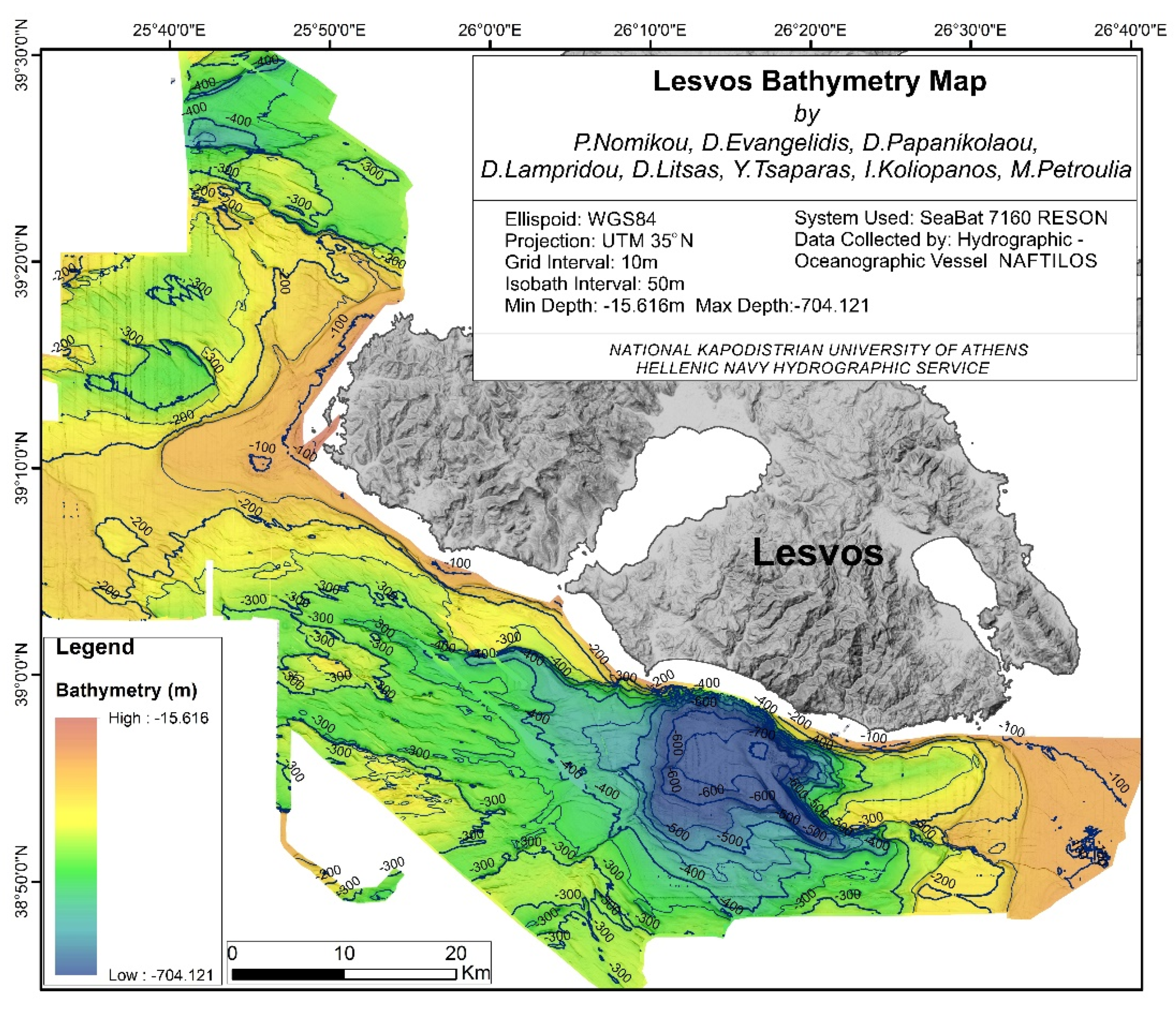
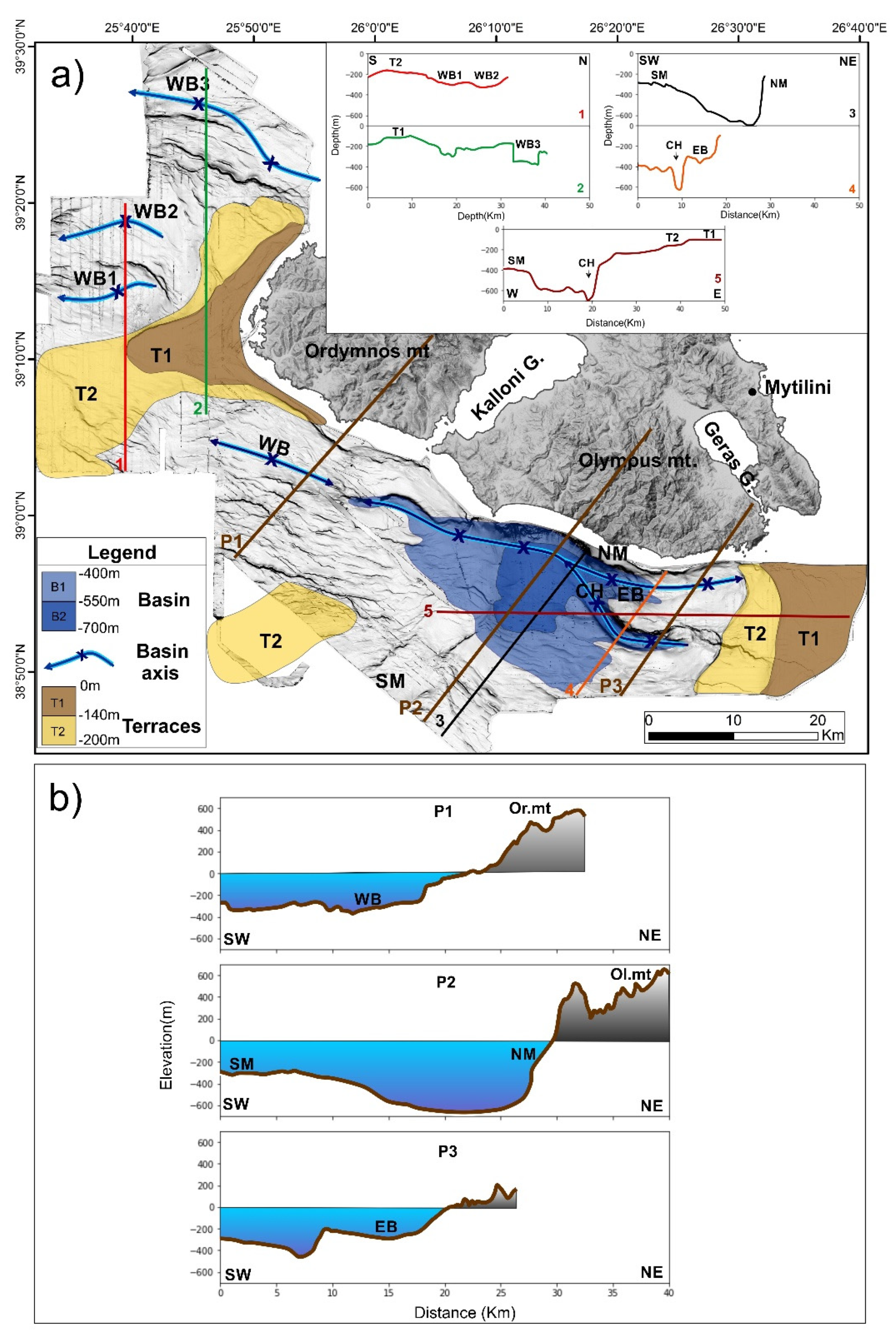
3.1. Swath Bathymetry

The resulting slope-shaded bathymetric map was initially compiled at 10 m spatial resolution (Figure 2). This map permits the first detailed description of the seafloor’s overall topography along the southwest margin of Lesvos Island and the distinction of the major morphological features summarized in Figure 3. The main morphological feature is the WNW-ESE basin, running parallel to the eastern segment of the southern Lesvos coastline. This basin corresponds to the so-called Lesvos Basin [27]. Its length is approximately 45 km, and its morphological axis is located at a short distance of 5–6 km from the coast. Its maximum depth is 704 m, and the deep sub-horizontal basinal area with depths between 550–700 m extends to about 340 km2 (B1 area in Figure 3). Thus, the basin is highly asymmetric with a very narrow northern slope contrary to the wide southern slope, which extends to 30–35 km towards the central Aegean Sea to the SSW, where a shallow-water platform with depths around 250–300 m has developed (profile 3 in Figure 3). A distinctive morphological feature of a narrow, deep NW-SE channel (600–650 m of depth) of about 8 km length is observed at the eastern part of the basin, with very abrupt slopes (profile 4 in Figure 3). The maximum depth of the basin occurs at the intersection of its WNW-ESE basinal axis with the northwestern prolongation of the NW-SE channel. The channel’s margins form abrupt cliffs from the adjacent platform areas, mainly towards the east (prolongation of Terrace T2 at 250 m of depth) and less to the west (450 m of depth), resulting in a depth difference of 400 m and 200 m, respectively (profile 4 in Figure 3). The overall geometry indicates the disruption of the southern slope of the basin by the narrow channel (2–3 km width). At both sides of the basin to the east before the exit of the Geras Gulf and to the west in front of the exit of the Kalloni Gulf the basin becomes shallower, with depths between 200–300 m, and it then dies out. East of the intersection of the main WNW-ESE basin with the NW-SE channel [25], the geometry of the basin changes, with much shallower depths around 250–300 m in the E-W direction, and the width of the basinal zone is reduced to only 2–3 km (profile 4 in Figure 3).
West of the exit of the Kalloni Gulf, along the western segment of the southern Lesvos coastline, there is the Western Basin, which forms a shallow asymmetric WNW-ESE basin/graben (300–350 m of depth), whose basinal axis lies at the prolongation of the main Lesvos Basin, running parallel to the coast at a distance of about 10 km. Three shallower basins (WB1, WB2, WB3), with depths between 300–400 m, are observed at the western margin of Lesvos Island with a generalized E-W orientation and lengths of 15 km (WB1, WB2) and more than 25 km (WB3) (profiles 1 and 2 in Figure 3). The three basins are separated from the southern margin of Lesvos Island by a wide submarine terrace zone, extending west-southwest of Lesvos from the area of Sigri. The upper terrace, T1, is observed at 140 m water depth, whereas the deeper terrace, T2, lies at about 200 m depth. Similar terraces to T1 and T2 are also observed at the opposite margin of Lesvos Island in front of the Geras Gulf exit (profile 5 in Figure 3).
The development of three morphological segments, corresponding to three basins along the southern Lesvos margin, is shown in three transverse topographic profiles extending from the offshore to the onshore area (Figure 3b). Thus, the geometries of the two shallow basins in the west (Western Basin, WB) and the east (Eastern Basin, EB) are contrasted to the geometry of the main Lesvos Basin. This morphological segmentation will be correlated to the tectonic segmentation of the three basins in the morphotectonic synthesis of Lesvos.

3.2. Morphological Slope Analysis

The slope distribution map shows the distribution of slope values within the study area, distinguished in six categories (Figure 4): (a) flat horizontal areas from 0–1°, (b) areas with very low slopes from 1–5°, (c) areas with low slopes from 5–10°, (d) areas with medium slopes from 10–20°, (e) areas with high slopes from 20–30°, and (f) areas with steep slopes >30°. This classification of the slope magnitude illustrates the zones where there is an abrupt slope change, reflecting possible positions of active tectonic zones, in contrast with zones with negligible or gradual slope change, reflecting homogeneous relief. The two extreme morphological slope features correspond to: (a) flat-lying sub-horizontal or very low slope areas such as submarine platforms/terraces or basinal areas. (b) narrow high or steep slope zones, usually corresponding to active fault zones. Non-linear zones of morphological discontinuity may result from other special morphological features such as volcanic structures, landslides, recently subsided terrestrial relief, etc. This morphotectonic analysis of morphological slopes was applied in the North Aegean and Skyros Basins with very good results regarding the location and striking direction of the active faulting, verified by litho-seismic profiles [26,28,29].
The highest slope values (>30°) are observed at the northern margin of the Lesvos Basin along a well-defined geometrical surface, oriented WNW-ESE and running parallel to the Lesvos southern coast. This high slope zone is observed along 45 km and covers the Lesvos margin from 150 m down to 700 m depth at its bottom. The high slope zone represents a normal fault dipping to the south with 35°–40° and corresponds to the basin’s marginal fault (Figure 4b). The maximum slope values around 45° are observed towards the western tip of the fault at the exit of the Kalloni Gulf. The basin’s southern margin is not characterized by significant slope discontinuities but by very low-low morphological slopes dipping to the north. Thus, the southern margin dips gradually northwards to the basinal area (from 300 m to 650 m of depth) without a southern marginal fault, and the overall geometry of the Lesvos Basin corresponds to a half-graben structure. Nevertheless, some secondary slope discontinuities with low to medium slopes are observed, separating sub-horizontal areas across the margin and forming deeper terrace-like features at depths between 300–550 m.
Steep morphological slopes with values up to 35° are observed along the two parallel cliffs of the NW-SE channel for a length of about 8 km. Sub-horizontal or very low slopes are observed along the bottom of the channel with an inclination towards the NW, at the deepest part of the basin.
At the western part of the southern Lesvos margin from the exit of the Kalloni Gulf to the area of Sigri, the geometry of the seafloor is very different, with shallower depths (up to 350 m) and very low slopes dipping towards the basin axis of the Western Basin. Along the northern margin of approximately 10 km width, a zone of WNW-ESE slope discontinuity dipping to the south is observed, whereas along the southern margin of approximately 20 km width there are three zones of slope discontinuity dipping to the north. The southernmost zone occurring at about 250 m of depth is the most important, disrupting the very low slopes of the southern margin with 34° of slope values.
Three basinal areas with sub-horizontal or very low slopes are observed at the western margin of Lesvos Island, with depths approximately 300–350 m (WB1 and WB2) and 350–400 m (WB3). One WNW-ESE zone of slope discontinuity dipping southwards borders the southern basin, WB1, from the median basin, WB2, whereas two WNW-ESE sub-parallel zones of slope discontinuity with maximum 35° dipping to the north border the median from the northern basin, WB3.
The prevailing orientation of the zones of slope discontinuities in the offshore area is WNW-ESE, as shown in the rose diagram (Figure 4c). NW-SE and NE-SW directions are minor, contrary to the onshore data of lineaments where the NE-SW direction is dominant and WNW-ESE and NW-SE are minor [30].
Sub-horizontal and very low morphological slope areas with 0–2° are also observed at very shallow depths at Lesvos Island’s western and eastern margin. These areas correspond to submarine terraces with an average depth of 140 m (T1) and 200 m (T2) (Figure 4b). The deeper terrace, T2, is also observed in some areas along the southern margin of the Western Basin. It is remarkable that the three WNW-ESE western basins form submarine cliffs along their slope discontinuities, which stop along a ENE-WSW zone, running parallel to the western terraces. This ENE-WSW zone is characterized by medium slope values, observed along a cliff of a few tens of m separating the terraces from the basins. Very low slopes (<5°) are observed in large intermediate areas extending between the shallow platforms and the basinal areas (Figure 4), representing either prolongation of the basinal areas towards the steep margins or submarine terrace-like structures at different depths.

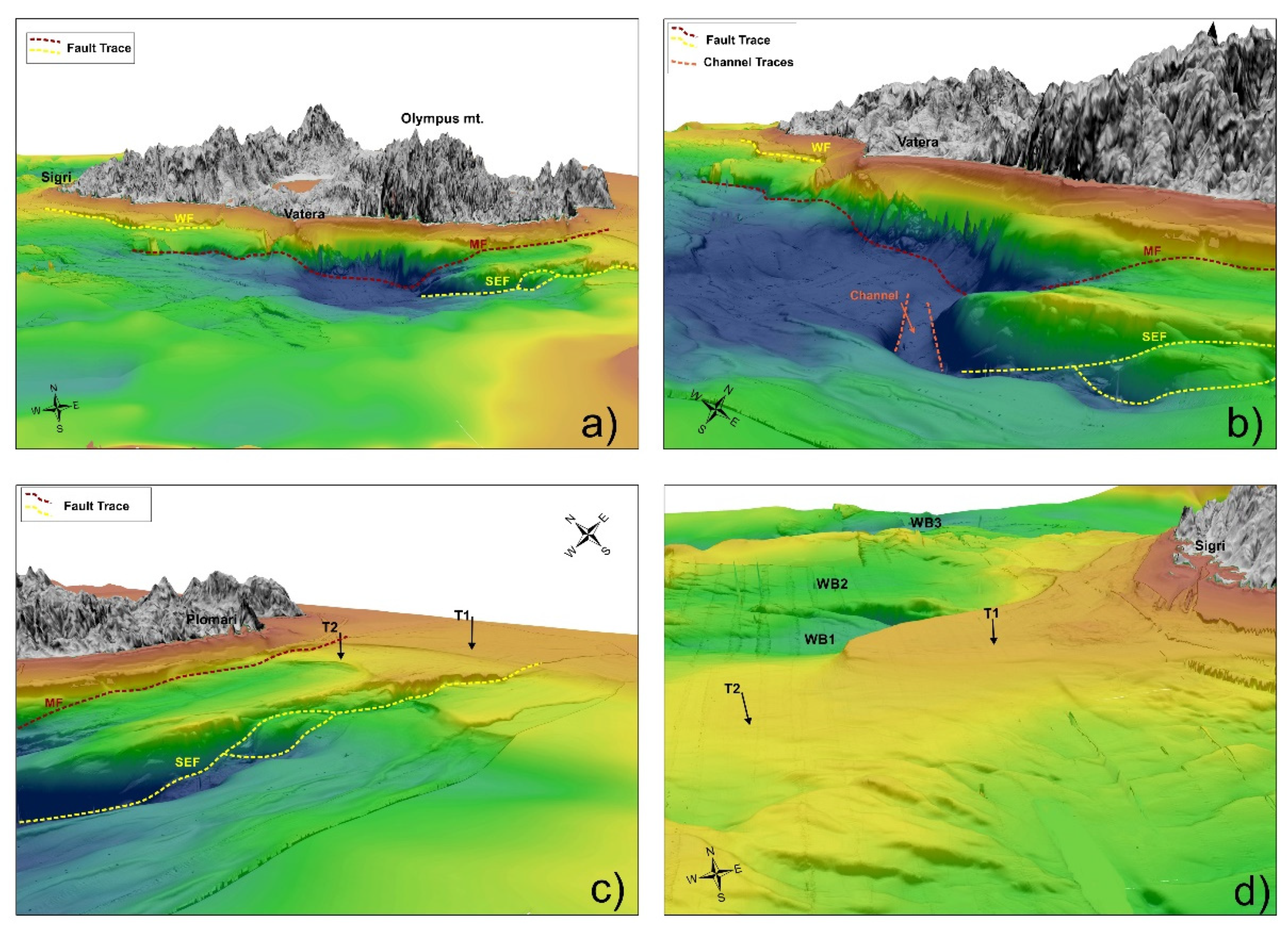
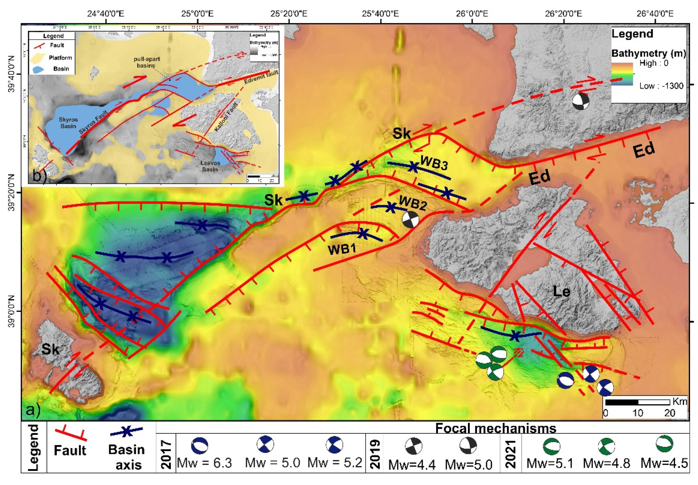
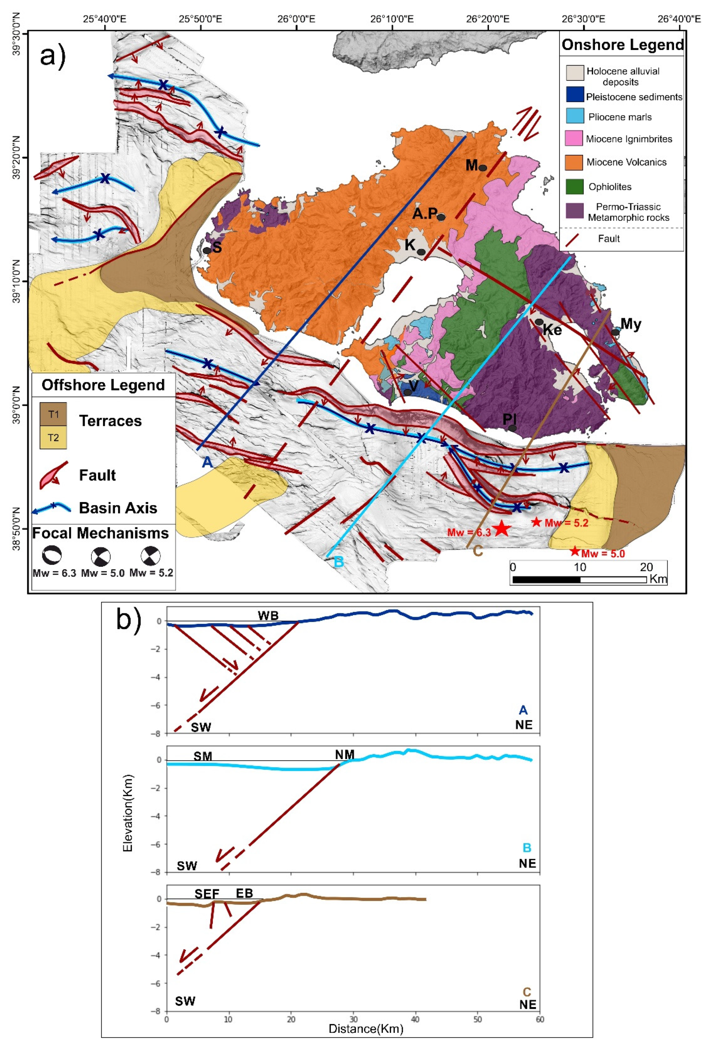
3.3. Morphotectonic Structure
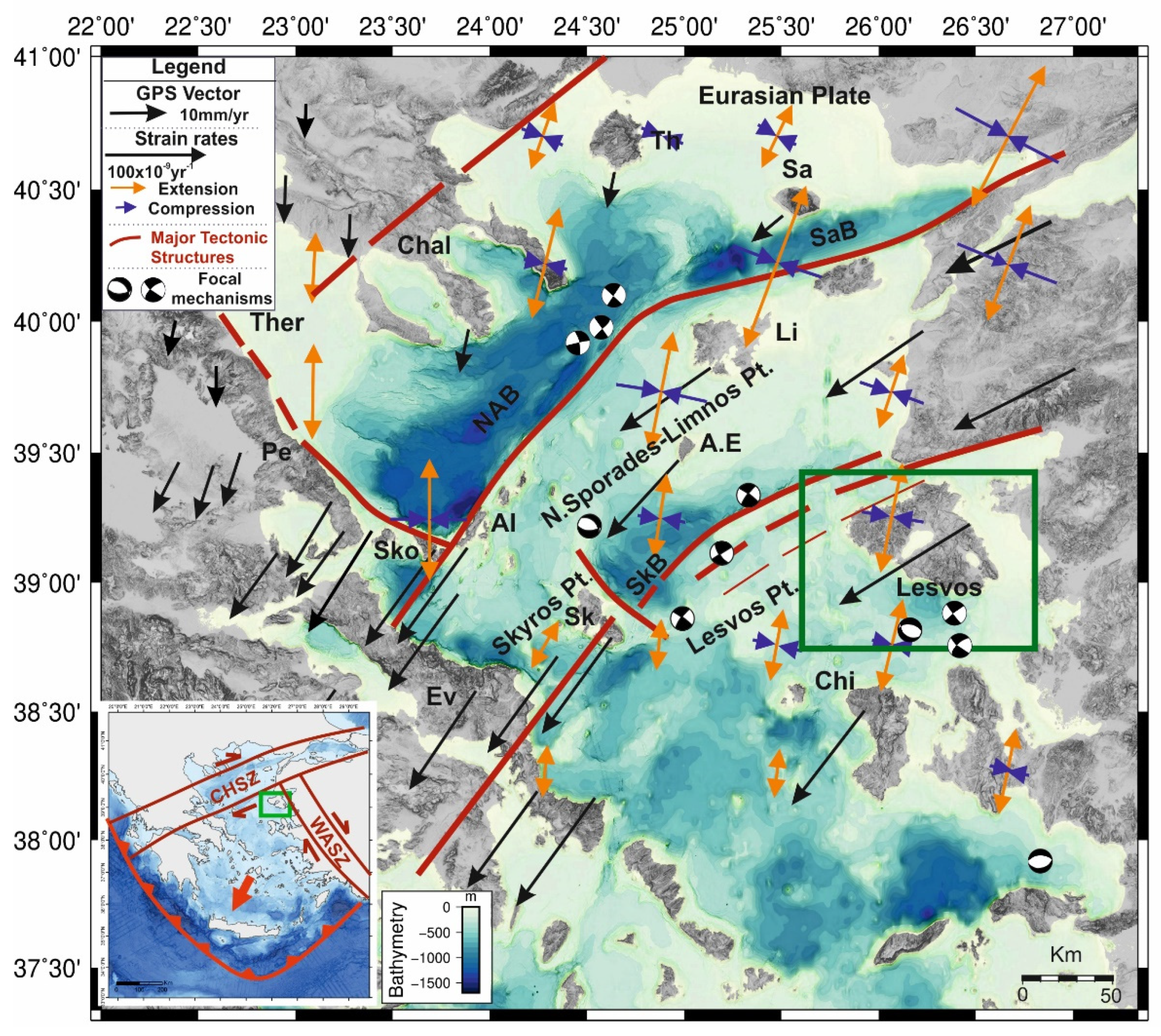
The overall morphotectonic structure of the Lesvos southern margin is differentiated along the 90 km length of the coastal zone. This is illustrated in the panoramic view of Lesvos Island’s onshore/offshore area seen from the south-southeast (Figure 5a). Thus, the eastern part of the margin is controlled for about 40 km by the WNW-ESE marginal fault of the Lesvos Basin with steep slopes (35°–45°), forming a steep submarine escarpment more than 600 m height. Remarkably, the maximum depth of the basin (704 m) at the hangingwall is opposed to the maximum altitude of the Lesvian Olympus mt. (942 m), which is made of alpine basement rocks (metamorphic rocks of the lower tectonic unit) in the footwall (see also morphological (P2) and tectonic (B) profiles in Figure 3b and Figure 6b). The resulting topographic difference across the fault is 1645 m. Therefore, the overall throw of the fault may be about 2 km if we also consider the additional thickness of the marine sediments occurring at the basinal area beneath the sea bottom, above the subsided alpine basement, which is estimated at several hundred m [25]. On the contrary, the southern margin of the basin is dipping northwards with very low slopes without a pronounced morphological discontinuity and, thus, the basin’s structure corresponds to a half-graben.
The Western Basin extending at the western part of the margin, west of the Kalloni Gulf exit, is shallower, with a WNW-ESE orientation and 350 m of depth (Figure 5a). Its geometry is relatively asymmetric, with three slope discontinuities observed at the southern margin and one at the northern. The hilly landscape of the Ordymnos mt., onshore Western Lesvos, comprises small altitudes up to 350 m, and it is made of Miocene volcanic rocks (see also morphological profile P1 in Figure 3b and tectonic profile A in Figure 6b). Hence, there is a considerable difference in the structure both onshore and offshore the southern Lesvos margin. This difference is located along the exit of the Kalloni Gulf, as well as along the Kalloni Gulf and further to the northeast up to the Aghia Paraskevi tectonic zone. This major tectonic boundary corresponds to the Kalloni-Aghia Paraskevi dextral strike-slip fault zone, which has been activated with strong earthquakes repeatedly [20,21].
The NW-SE narrow channel disrupting the eastern part of the Lesvos Basin is shown from the southeast (Figure 5b). The two parallel morphological discontinuities show opposite dips, with steep slopes around 35°. The channel disrupts the southern margin of the basin and delimits the shallow terrace, T2, to the west. Additionally, the eastern part of the basin, east of its intersection with the channel, becomes very shallow (250–300 m) and narrow (3–4 km), forming the Eastern Basin.
The eastern part of the southern Lesvos margin is characterized by two extended sub-horizontal surfaces forming submarine terraces T1 and T2 at depths of 140 m and 200 m, respectively (Figure 5c). The upper terrace, T1, extends towards the east-northeast, up to the exit of the Geras Gulf. The lower Terrace, T2, forms a 5–10 km width zone bordering the upper terrace to the west. Approximately 10 km from the coast, the two terraces form a submarine cliff due to the southeastern fault (SEF), dividing the lower terrace, T2, in a northern segment of 4 km width from a southern segment of 7–8 km width. The vertical displacement is several m high, with a gradual decrease towards the upper terrace, T1, in the east. The same E-W structure continues westwards, forming a relay ramp, with increasing displacement up to its junction with the southern exit of the NW-SE channel.
The western part of the southern Lesvos margin is made of an extended sub-horizontal area of shallow depths between 100–200 m, with an upper terrace, T1, at 140 m and a lower terrace at 200 m, similar to those terraces observed at the eastern margin (Figure 5d). The upper terrace, T1, developed from the coastal zone of Sigri, where remains of a fossilified forest within the Miocene volcanics are observed at shallow depths, up to 15 km towards the WSW. The lower terrace, T2, extends from this area further to the WSW for at least another 15 km. Thus, the overall area of the two submarine terraces in western Lesvos extends to more than 300 km2. This platform area separates the southern Lesvos margin with the two basins (the shallow in the west and the deep in the east) from the northwestern Lesvos margin, where the three WNW-ESE subparallel shallow basins WB1, WB2, and WB3, are observed. Contrary to the extension of the terraces westwards, their development northwards is very limited, and the lower terrace, T2, especially, has practically disappeared, probably because of an ENE-WSW tectonic zone.
The morphotectonic structure of the offshore southern Lesvos margin can be correlated with the onshore Lesvos Island structure as it is simplified in the morphotectonic map (Figure 6). The major structure is the Kalloni—Aghia Paraskevi NE-SW trending dextral strike-slip fault zone, dividing Lesvos Island in a northwestern part, where thick Miocene volcanic rocks dominate, and a southeastern part, where the alpine basement crops out with only a thin cover of Miocene ignimbrites restricted along the southeastern block of the fault zone. Thus, the two neotectonic blocks of Lesvos on both sides of the strike-slip fault are very different, the only common geological formation being the Permo-Triassic metamorphic rocks cropping out beneath the Miocene volcanics along the northwestern coastal zone to the northwest of Sigri. It is also remarkable that the Miocene ignimbrites of the southeastern block represent the final volcanic products (deposited approximately 16 m years ago) of the overall volcanic activity (which took place 20–16 m years ago). The top of the Miocene ignimbrites forms a distinct morphological planation surface, which is interrupted along the 20 km length strike-slip fault from Aghia Paraskevi up to the coastal area northeast of Mantamado. In contrast, in the northwestern block, the morphology comprises the hilly volcanic landscape of Lepetymnos mt. The fault zone continues towards the southwest along the 25 km length of the shallow Kalloni Gulf and further into the offshore area, where it separates the deep Lesvos Basin to the east from the shallow Western Basin to the west.
It is remarkable that the morphological and tectonic segmentation of the WNW-ESE Lesvos southern margin in three basins is effected by two strike-slip fault zones: the southwestern prolongation of the NE-SW Kalloni fault separating the Western Basin from the Lesvos Basin and the NW-SE fault zone of the channel, separating the Lesvos Basin from the Eastern Basin. The characteristic structure of the three basins is illustrated in the morphological profiles of Figure 3b and the tectonic profiles of Figure 6b. Thus, (i) the central deep Lesvos Basin forms a half-graben with a marginal fault dipping to the SSW, whereas (ii) the shallow Western Basin forms am asymmetric graben, with a marginal fault dipping to the SSW and three antithetic faults dipping to the NNE, and (iii) the shallow Eastern Basin forms a more complex structure, with a marginal fault dipping to the SSW and a minor antithetic fault dipping to the NNE, followed towards the south by the Southeastern major fault (SEF) dipping to the SSW, which becomes more active and propagates eastwards on the T1 and T2 terraces.
The next major tectonic structure onshore Lesvos is the WNW-ESE trending fault bordering the two gulfs of Kalloni and Geras towards the northeast (Figure 6). This fault is observed mainly at Keramia at the northwestern coast of the Geras Gulf, where it forms a cliff of 250 m. The basal formations of the metamorphic rocks built the footwall of the fault, whereas Pleistocene alluvial deposits are observed in the hanging wall, and its throw is estimated to exceed 400 m [13,21]. Towards the northwest, the fault continues through the ophiolites and the overlying ignimbrites up to Kalloni town. Remarkably, the same WNW-ESE orientation is observed offshore in the three basins of the northwestern Lesvos margin, where the two northern zones dip northwards in the subsided basinal area.
Other secondary morphotectonic structures of a NW-SE direction are observed both onshore and offshore (Figure 6). Onshore, the NW-SE structures are observed in the area of Vatera–Vryssa, forming a graben structure filled with Plio-Pleistocene sediments and in the area of Geras Gulf and Amali Peninsula, forming a graben and a horst, respectively. The easternmost fault is observed along the northeastern rectilinear coastline of Lesvos, passing from Mytilini, where it has bordered the Neogene lacustrine sediments from the ophiolitic Alpine basement of the Amali peninsula. Offshore, the NW-SE structures are mainly observed to the south of Plomari, where they form the channel, disrupting the eastern part of the Lesvos Basin. These NW-SE structures are observed only at the southeastern block of Lesvos. Notably, the offshore NW-SE channel structures are observed only at the hanging wall and stop along the WNW-ESE major marginal fault of the Lesvos Basin, in the same was as the onshore NW-SE structures forming the Vatera graben structure observed only at the footwall of the fault. Thus, the NW-SE structures developed onshore in the Vatera area and offshore in the channel are localized along the same NW-SE trend, interrupted by the WNW-ESE marginal fault of the Lesvos Basin.

4. Discussion

The above tectonic structure of the SE Lesvos Basin was reflected in the seismic activity of June 2017. Thus, as expressed by the 2017 seismicity, the active tectonics are in accordance with the previous neotectonic deformation [21,23]. A major earthquake of magnitude 6.3 was located on the WNW-ESE normal fault, forming the basin/half-graben’s northern margin at approximately 8–10 km depth [22,24,25]. The earthquake focus location corresponds to a fault dip of about 45°, similar to the morphological slope presented in Figure 4a,b, and the focal mechanism shows a normal fault [24]. On the contrary, the two major aftershocks of magnitude 5.2 and 5.0 showed sinistral strike-slip motion along the NW-SE direction, along two parallel sub-vertical faults with dips of 82° and 75° to the NE [22,24], corresponding to the two NW-SE faults forming the narrow channel [25]. The main normal fault of WNW-ESE direction dipping to the SSE is nicely integrated to the regional deformation pattern, with extension in the NNE-SSW direction, which is also the geodetic trend of the annual GPS rates of the Aegean micro-plate and the resulting strain rate (e.g., [1]). The NW-SE sinistral strike-slip fault zone may correspond to a lateral accommodation of the deformation along the eastern margin of the Aegean microplate, adjacent to the sinistral West Anatolian Shear Zone [10].
Observations presented within a coastal geomorphological study concluded that an uplift is taking place along the southern coast in a WNW-ESE direction from Aghios Fokas Cape at the exit of the Kalloni Gulf up to the Vatera and Plomari area, corresponding to the activity of the Lesvos marginal fault [31]. The chronological data pointed to a seismic event of magnitude 6.6 at about 3.6–4.0 Ka, which has caused an uplift of the coast by about 0.75 m. Several older events are also indicated along this 20 km long coastal zone during the last 30 Ka, with uplifted markers up to 5 m. Thus, the neotectonic deformation is in accordance with the present-day seismic activity. The same study concluded that there is no uplift along the western coast of Lesvos in the area of Gavathas in a NE-SW direction, but instead there is some small subsidence, indicating a different tectonic regime.
The bathymetric data of our survey reached the northwest the eastern part of the Skyros Basin strike-slip tectonic zone, which represents the southern strand of the North Anatolian zone in the Aegean [26]. Thus, there is the possibility to link the Lesvos structures with the Skyros strike-slip system by combining the two bathymetric datasets (Figure 7).
The eastern part of the Skyros Basin is characterized by a ENE-WSW direction, with gradual depth decrease towards the ENE from 700 m to 400 m. South of the basin there is a shallow water platform with depths 100–200 m, comparable to the submarine terraces of western Lesvos. The three basins, WB1, WB2, and WB3, of the Lesvos northwestern margin lie between the Skyros structure and its bordering platform from the south. The dominant structure of the three basins is expressed by the orientation of the morphological discontinuities/faults and the sub-parallel orientation of the basinal axes in the NW-SE to WNW-ESE direction. Another ENE-WSW major structure forms the southern boundary of the overall alternation of the WNW-ESE platforms and shallow basins, running parallel to the Lesvos coast and terraces, probably joining the Adramytion (Edremit) fault of the southern coast of the Biga Peninsula on the opposite coast of Turkey. The complex alternation of WNW-ESE platforms and shallow basins lies between the two sub-parallel boundary dextral strike-slip fault zones of the Skyros Basin to the north and the Adramytion Fault to the south. Thus, the three western basins (WB1, WB2, and WB3) represent pull-apart basins within the complex zone of the southern strand of the North Anatolian Fault in the Aegean, as shown in the inset tectonic sketch of Figure 7b. It is remarkable that a 4.4 magnitude earthquake occurred at the Western Basin of the Lesvos southern margin in 2019. The location, magnitude, and focal mechanism of this earthquake correspond to the activation of a segment of the ENE-WSW strike-slip marginal fault of the WB1 and WB2 western basins of Lesvos. Another earthquake of magnitude 5.0, also with a strike-slip focal mechanism, occurred in 2019 at the prolongation of the Skyros strike-slip fault zone (Figure 7a). Finally, three earthquakes occurred during 2021 at the southern margin of the Western Basin of Lesvos, two of them of magnitude 5.1 and 4.5 with normal WNW-ESE focal mechanisms, and another of magnitude 4.8 with a NE-SW strike-slip focal mechanism (Figure 7a). These seismic events correspond to the activation of the mapped faults at the southern margin between the Western Basin and the main Lesvos Basin. Thus, the 2021 seismic activity along the Lesvos margin comprised both normal and strike-slip faulting, similar to the 2017 activity a few tens of km eastwards.
Therefore, the morphotectonic structures of Lesvos Island are similar to the major structures all over the North Aegean Sea, where the major NE-SW tectonic trend dominates, usually corresponding to dextral strike-slip faults, and the minor NW-SE tectonic trend is present, corresponding either to normal faults or to sinistral strike-slip faults [26,28,29,32]. Some cases of WNW-ESE to E-W trending faults are also present, corresponding to normal faults that have been seismically activated recently, as in Lesvos (2017) and Samos (2020) [24,25,33,34]. The NE-SW strike-slip faults are observed mainly along the northern boundary of the Aegean micro-plate [10,18,35,36,37]. Nevertheless, dextral strike-slip focal mechanisms have also been calculated further south within the Aegean plate up to the 38° parallel between Southern Evia and Chios. The NW-SE normal faults are observed at the western tips of the strike-slip zones of the North Aegean Basin [28,29] and of the Skyros Basin [26]. However, WNW-ESE to E-W oriented normal faulting occurs along the Aegean coastal zone of Western Anatolia [7,18]. Considering the GPS data showing a southwestern vector of 30 mm [2], the two major fault sets accommodate this motion, with lateral slip along the NE-SW strike-slip faults and opening across the WNW-ESE normal faults.
The extended presence of submarine terraces T1 and T2 enables the understanding of the geodynamic evolution since the Middle/Late Pleistocene period with the successive events of low-stands and high-stands of the sea level during the climatic changes. The usual depth of the last low-stand at the end of the last glacial period of the Late Pleistocene in the Mediterranean is 123 m [38], whereas in the southern Lesvos margin, it is 140 m. This deeper position of T1 may be due to the regional subsidence observed all over the North Aegean Sea, with a rate ranging between 1.46 and 1.88 m/Ka [39], which corresponds to an additional depth of about 20 m. It is remarkable that the terraces are not observed along the faulted margin of the Lesvos Basin east of the Kalloni Gulf exit; the terraces are ruptured both at the eastern margin from the southeastern fault (Figure 5c and Figure 6a) and at the western margin by the ENE-WSW fault bordering the western basins WB1 and WB2 (Figure 6a and Figure 7a).

5. Conclusions

In conclusion, the tectonic structure of Lesvos Island, both offshore and onshore, is similar to the overall regional deformation of the North Aegean area, where the two main strands of the western prolongation of the North Anatolian Fault form the North Aegean and the Skyros basins. The three Lesvos western basins are pull-aparts of the strike-slip fault zone between the Skyros Fault and the Adramytion (Edremit) Fault. The seismic activity since 2017 has shown the co-existence of normal faulting and strike-slip faulting throughout the 90 km long Lesvos southern margin. This combination of normal faulting, usually in the WNW-ESE direction, and strike-slip faulting, primarily in the NE-SW direction and secondarily NW-SE direction is observed all over the North Aegean area, accommodating the southwestward motion of the Aegean micro-plate.

Author Contributions

Conceptualization, P.N. and D.P.; methodology, D.L. (Dimitris Litsas), D.E. and D.L. (Danai Lampridou); software, D.L. (Danai Lampridou) and D.L. (Dimitris Litsas); validation, all authors; resources, D.E.; data curation, D.L. (Dimitris Litsas), Y.T., I.K. and M.P.; writing—original draft preparation, D.P., P.N. and D.L. (Danai Lampridou); writing—review and editing, all authors; visualization, D.L. (Danai Lampridou); supervision, P.N.; project administration, D.P. All authors have read and agreed to the published version of the manuscript.

Funding

This research received no external funding.

Institutional Review Board Statement

Not applicable.

Informed Consent Statement

Not applicable.

Acknowledgments

The officers and crew of the R/V NAFTILOS of the Hellenic Navy Hydrographic Service are gratefully acknowledged. For the data processing, visualization, and bathymetric maps, we used the freely available software package Arcmap 10.7.

Conflicts of Interest

The authors declare no conflict of interest.

References

  1. McClusky, S.; Balassanian, S.; Barka, A.; Demir, C.; Ergintav, S.; Georgiev, I.; Veis, G. Global Positioning System constraints on plate kinematics and dynamics in the eastern Mediterranean and Caucasus. J. Geophys. Res. 2000, 105, 5695–5719. [Google Scholar] [CrossRef]
  2. Reilinger, R.; McClusky, S.; Paradissis, D.; Ergintav, S.; Vernant, P. Geodetic constrains on the tectonic evolution of the Aegean region and strain accumulation along Hellenic subduction zone. Tectonophysics 2010, 488, 22–30. [Google Scholar] [CrossRef]
  3. Müller, M.D.; Geiger, A.; Kahle, H.G.; Veis, G.; Billiris, H.; Paradissis, D.; Felekis, S. Velocity and deformation fields in the North Aegean domain, Greece, and implications for fault kinematics, derived from GPS data 1993–2009. Tectonophysics 2013, 597–598, 34–49. [Google Scholar] [CrossRef]
  4. Kreemer, C.; Holt, W.E.; Haines, A.J. An integrated global model of present-day plate motions and plate boundary deformation. Geophys. J. Int. 2003, 154, 8–34. [Google Scholar] [CrossRef] [Green Version]
  5. Kreemer, C.; Blewitt, G.; Klein, E.C. A geodetic plate motion and global strain rate model. Geochem. Geophys. Geosyst. 2014, 15, 3849–3889. [Google Scholar] [CrossRef]
  6. Vernant, P.; Reilinger, R.; McClusky, S. Geodetic evidence for low coupling on the Hellenic subduction plate interface. Earth Planet Sci. Lett. 2014, 385, 122–129. [Google Scholar] [CrossRef]
  7. Kiratzi, A.; Louvari, E. Focal mechanisms of shallow earthquakes in the Aegean Sea and the surrounding lands determined by waveform modeling: A new database. J. Geodyn. 2003, 36, 174–251. [Google Scholar] [CrossRef]
  8. Kiratzi, A.A. Mechanisms of earthquakes in Aegean. In Encyclopedia of Earthquake Engineering; Beer, M., Kougioumtzoglou, I.A., Patelli, E., Siu-Kui Au, I., Eds.; Springer: Berlin/Heidelberg, Germany, 2014; pp. 1–22. [Google Scholar]
  9. Meng, J.; Sinoplu, O.; Zhou, Z.; Tokay, B.; Kusky, T.; Bozkurt, E.; Wang, L. Greece and Turkey Shaken by African tectonic retreat. Sci. Rep. 2021, 11, 6486. [Google Scholar] [CrossRef] [PubMed]
  10. Papanikolaou, D.; Royden, L. Disruption of the Hellenic arc: Late Miocene extensional detachment faults and steep Pliocene-Quaternary normal faults—Or what happened at Corinth? Tectonics 2007, 26, 1–16. [Google Scholar] [CrossRef]
  11. Papanikolaou, D. Timing of tectonic emplacement of the ophiolites and terrane paleogeography of the Hellenides. Lithos 2009, 108, 262–280. [Google Scholar] [CrossRef]
  12. Papanikolaou, D. The Geology of Greece; Springer: Berlin/Heidelberg, Germany, 2021; p. 345. [Google Scholar] [CrossRef]
  13. Hecht, J. Geological Map of Lesvos Island at Scale 1/50,000. Sheets Plomari-Mytilini, Eressos, Polychnitos; IGME: Athens, Greece, 1972–1975. [Google Scholar]
  14. Katsikatsos, G.; Migiros, G.; Triantaphyllis, M.; Mettos, A. Geological Structure of the Internal Hellenides (E. Thessaly-SW. Macedonia, Euboea-Attica- Northern Cyclades Islands and Lesvos). Geol. Geophys. Res. 1986, 191–212. [Google Scholar]
  15. Pe-Piper, G.; Piper, D.J.W. The Igneous Rocks of Greece: The Anatomy of an Orogen; Gebrüder Borntraeger: Berlin, Gemany, 2002; p. 573. [Google Scholar]
  16. Papazachos, B.C.; Papaioannou, C.H.A.; Papazachos, C.B.; Savvaidis, A.A. Atlas of isoseismal maps for strong earthquakes in Greece and surrounding area. Publ. Geophys. Lab. Univ. Thessalon. 1997, 4, 200. [Google Scholar]
  17. Papazachos, B.C.; Papazachou, C. The Earthquakes of Greece; Ziti Publishing Co.: Thessaloniki, Greece, 2003; p. 286. (In Greek) [Google Scholar]
  18. Taymaz, T.; Jackson, J.A.; McKenzie, D. Active tectonics of the North and Central Aegean Sea. Geophys. J. Int. 1991, 106, 433–490. [Google Scholar] [CrossRef]
  19. Taymaz, T.; Yılmaz, Y.; Dilek, Y. The geodynamics of the Aegean and Anatolia: Introduction. Geol. Soc. Lond. Spec. Publ. 2007, 291, 1–16. [Google Scholar] [CrossRef]
  20. Roumelioti, Z.; Kiratzi, A. Incorporating different source rupture characteristics into simulations of strong ground motion from the 1867, M 7.0 earthquake on the Island of Lesvos (NE Aegean Sea, Greece). Bull. Geol. Soc. Greece XLIII/4 2010, 43, 2135–2143. [Google Scholar] [CrossRef]
  21. Chatzipetros, A.; Kiratzi, A.; Sboras, S.; Zouros, N.; Pavlides, S. Active faulting in the north-eastern Aegean Sea Islands. Tectonophysics 2013, 597–598, 106–122. [Google Scholar] [CrossRef]
  22. Papadimitriou, P.; Kassaras, I.; Kaviris, G.; Tselentis, G.A.; Voulgaris, N.; Lekkas, E.; Kleanthi, M. The 12th June 2017 Mw = 6.3 Lesvos earthquake from detailed seismological observations. J. Geodyn. 2017, 115, 23–42. [Google Scholar] [CrossRef]
  23. Lekkas, E.; Mavroulis, S.; Skourtsos, E.; Andreadakis, E.; Antoniou, V.; Kranis, C.; Soukis, K.; Lozios, S.; Alexoudi, V. Earthquake environmental effects induced by the 2017 June 12, Mw 6.3 Lesvos (North Aegean Sea, Greece) earthquake. In Proceedings of the 8th International INQUA Meeting on Paleoseismology, Active Tectonics and Archeoseismology (PATA), Blenheim, New Zealand, 13–16 November 2017. [Google Scholar]
  24. Kiratzi, A. The 12 June 2017 Mw 6.3 Lesvos Island (Aegean Sea) earthquake: Slip model and directivity estimated with finite-fault inversion. Tectonophysics 2018, 724–725, 1–10. [Google Scholar] [CrossRef]
  25. Nomikou, P.; Papanikolaou, D.; Lampridou, D.; Blum, M.; Hübscher, C. The active tectonic structures along the southern margin of Lesvos Island, related to the seismic activity of July 2017, Aegean Sea, Greece. Geo-Mar. Lett. 2021. accepted. [Google Scholar] [CrossRef]
  26. Papanikolaou, D.; Nomikou, P.; Papanikolaou, I.; Lampridou, D.; Rousakis, G.; Alexandri, M. Active tectonics and seismic hazard in Skyros Basin, North Aegean Sea, Greece. Mar. Geol. 2019, 407, 94–110. [Google Scholar] [CrossRef]
  27. Mascle, J.; Martin, L. Shallow structure and recent evolution of the Aegean Sea: Asynthesis based on continuous reflection profiles. Mar. Geol. 1990, 94, 271–299. [Google Scholar] [CrossRef]
  28. Papanikolaou, D.; Nomikou, P.; Alexandri, M.; Ballas, D. Morphotectonic structure of the western part of the North Aegean basin based on swath bathymetry. Mar. Geol. 2002, 190, 465–492. [Google Scholar] [CrossRef]
  29. Papanikolaou, D.; Nomikou, P.; Alexandri, S. Active faulting in the North Aegean basin. Geol. Soc. Am. Spec. Pap. 2006, 409, 189–209. [Google Scholar]
  30. Novak, I.; Soulakellis, N. Identifying geomorphic features using LANDSAT-5/TM data processing techniques on Lesvos, Greece. Geomorphology 2000, 34, 101–109. [Google Scholar] [CrossRef]
  31. Vacchi, M.; Rovere, A.; Zouros, N.; Desruelles, S.; Caron, V.; Firpo, M. Spatial distribution of sea-level marker on Lesvos Island (NE Aegean Sea): Evidence of differential relative sea-level changes and the neotectonic implications. Geomorphology 2012, 159, 50–62. [Google Scholar] [CrossRef] [Green Version]
  32. Ganas, A.; Drakatos, G.; Pavlides, S.B.; Stavrakakis, G.N.; Ziazia, M.; Sokos, E.; Karastathis, V.K. The 2001 Mw = 6.4 Skyros earthquake, conjugate strike slipstrike-slip faulting and spatial variation in stress within the central Aegean Sea. J. Geodyn. 2005, 39, 61–77. [Google Scholar] [CrossRef] [Green Version]
  33. Kiratzi, A.; Papazachos, C.; Özacar, A.; Pinar, A.; Kkallas, C.; Sopaci, E. Characteristics of the 2020 Samos earthquake (Aegean Sea) using seismic data. Bull. Earthq. Eng. 2021, 1–23. [Google Scholar] [CrossRef]
  34. Nomikou, P.; Evangelidis, D.; Papanikolaou, D.; Lampridou, D.; Litsas, D.; Tsaparas, Y.; Koliopanos, I. Morphotectonic Analysis along the Northern Margin of Samos Island, Related to the Seismic Activity of October 2020, Aegean Sea, Greece. Geosciences 2021, 11, 102. [Google Scholar] [CrossRef]
  35. McKenzie, D.P. Plate tectonics in the Mediterranean Region. Nature 1970, 226, 239–243. [Google Scholar] [CrossRef]
  36. McKenzie, D.P. Active tectonics of the Mediterranean Region. Geophys. J. R. Astron. Soc. 1972, 30, 109–185. [Google Scholar] [CrossRef] [Green Version]
  37. McKenzie, D. Active tectonics of the Alpine-Himalayan belt: The Aegean Sea and surrounding regions. Geophys. J. R. Astron. Soc. 1978, 55, 217–254. [Google Scholar] [CrossRef] [Green Version]
  38. Roussakis, G.; Karageorgis, A.P.; Conispoliatis, N.; Lykousis, V. Last glacial—Holocene sediment sequences in N. Aegean basins: Structure, accumulation rates and clay mineral distribution. Geo.-Mar. Lett. 2004, 24, 97–111. [Google Scholar] [CrossRef]
  39. Lykousis, V. Sea-level changes and shelf break prograding sequences during the last 400ka in the Aegean margins: Subsidence rates and palaeogeographic implications. Cont. Shelf Res. 2009, 29, 2037–2044. [Google Scholar] [CrossRef]
Figure 1. The studied area of Lesvos Island at the eastern Aegean Sea. Its location lies at the junction of the two Aegean micro-plate boundaries, represented by the Central Hellenic Shear Zone (CHSZ) and the West Anatolian Shear Zone (WASZ) (Inset Map, modified by Ref. [10]).
Geohazards 02 00023 g001
Figure 2. Bathymetric map of the Lesvos southwestern margin.
Geohazards 02 00023 g002
Figure 3. (a) Simplified morphological map of the Lesvos southwestern margin and topographic profiles across the major structures of the area. T1 and T2 represent the submarine terraces. WB1, WB2, and WB3 represent the three western basins. WB represents the shallow Western Basin. NM and SM represent the northern and southern margin of the Lesvos Basin. EB represents the Eastern Basin. CH represents the channel. (b) Three topographic profiles through the Western basin (WB, P1), the main Lesvos Basin with its northern (NM) and southern (SM) margin (P2), and the Eastern Basin (EB, P3). Or.mt: Ordymnos mt. Ol.mt: Olympus mt.
Geohazards 02 00023 g003
Figure 4. (a) Morphological slope map of the studied area. (b) Simplified morphotectonic map of the Lesvos southwestern margin resulted from the interpretation of the morphological slope map. (c) Rose diagram of the zones of slope discontinuities (24 measurements).
Geohazards 02 00023 g004
Figure 5. Panoramic views of the offshore/onshore relief along the Lesvos southwestern margin. (a) View from the south of the southern Lesvos margin. (b) View from the southeast of the NW-SE channel disrupting the eastern part of the Lesvos Basin. (c) View from the southwest of the Terraces T1 and T2 at the eastern Lesvos margin. (d) View from the southeast of the Terraces T1 and T2 at the western Lesvos margin. MF: main fault of the northern margin of the Lesvos Basin, WF: Western fault of the northern margin of the Western Basin, SEF: Southeastern fault, running south of the Eastern Basin and disrupting the T1 and T2 terraces at the eastern margin of Lesvos.
Geohazards 02 00023 g005
Figure 6. (a) Morphotectonic map of Lesvos combining offshore and onshore structures. The red stars correspond to the major shock, F1, (6.3) and the two major aftershocks (5.2 and 5.0) activated during the 2017 seismic activity. Fault plane solutions of the main shock and two major aftershocks after [24]. S: Sigri, V: Vatera, Pl: Plomari, K: Kalloni, A.P.: Aghia Paraskevi, M: Mantamado, Ke: Keramia, My: Mytilini, Le mt: Lepetymnos mt., Ol mt: Olympus mt. (b) Three tectonic profiles across the Western Basin (A), the main Lesvos Basin (B), and the Eastern Basin (C) (see also the morphological profiles in Figure 3b). WB: Western Basin, NM: northern margin of the Lesvos Basin, SM: southern margin of the Lesvos Basin, EB: Eastern Basin, SEF: southeastern fault.
Geohazards 02 00023 g006
Figure 7. (a) Simplified morpho-tectonic map of the Skyros Basin and related strike-slip fault zone and the Lesvos western marginal structures, based on this study and [26]. (b) Tectonic sketch of the Skyros and Lesvos structures, showing the pull-apart nature of the Lesvos western basins, WB1, WB2, and WB3, in between the Skyros and Edremit strike-slip fault zones. Sk: Skyros, Le: Lesvos, Ed: Edremit. Moment Tensor solutions: https://orfeus.gein.noa.gr/gisola/realtime/2021/ (accessed on 13 December 2021).
Geohazards 02 00023 g007
Publisher’s Note: MDPI stays neutral with regard to jurisdictional claims in published maps and institutional affiliations.

