Towards a Semi-Quantitative Approach for Assessing Evacuation Scenarios in the Context of Popocatépetl Volcano, México—The Case of San Pedro Tlalmimilulpan
Abstract
:1. Introduction
2. Materials and Methods
2.1. Volcanic Phenomena, Hazard Maps and the Volcanic Traffic Light Alert System (VTLAS)
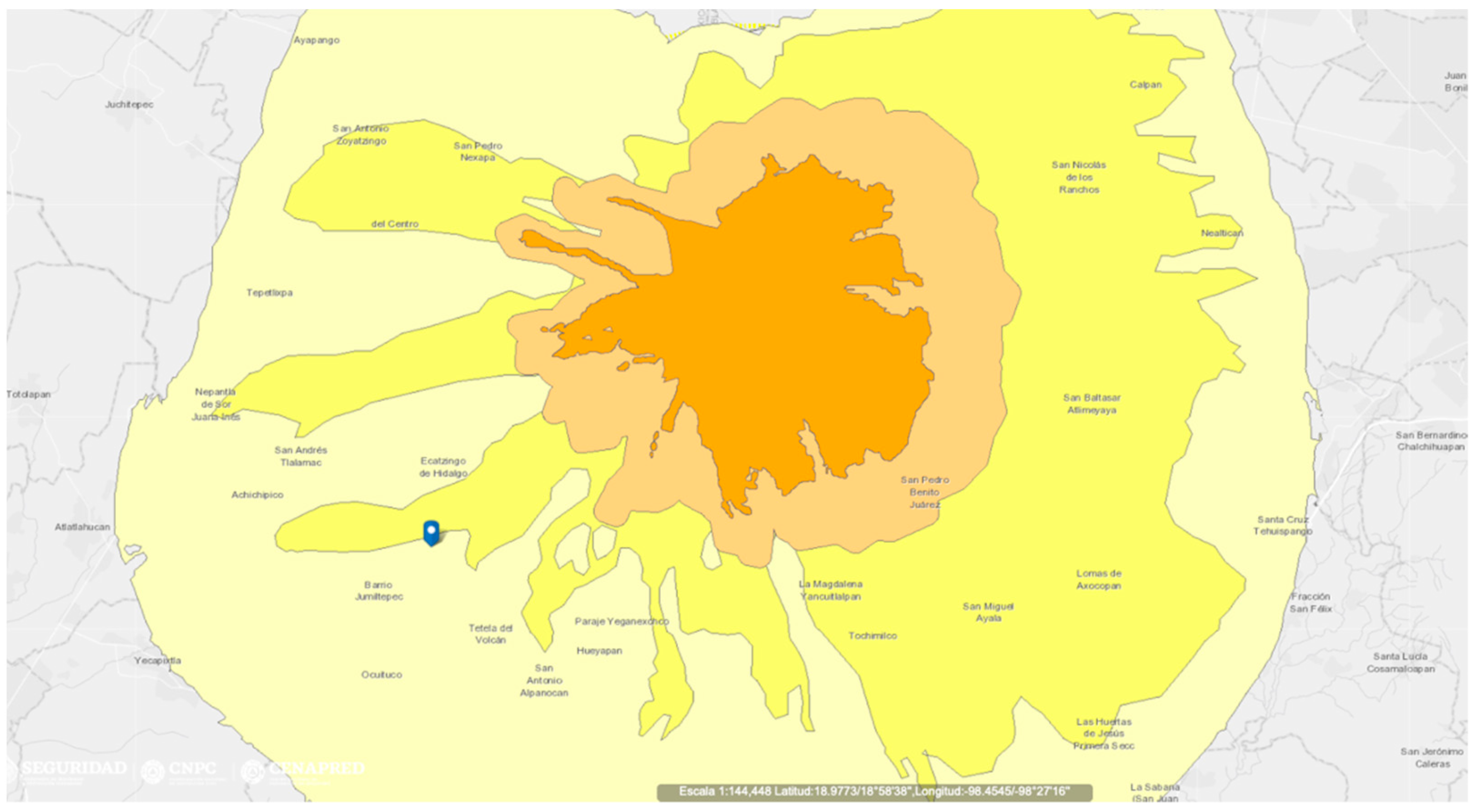
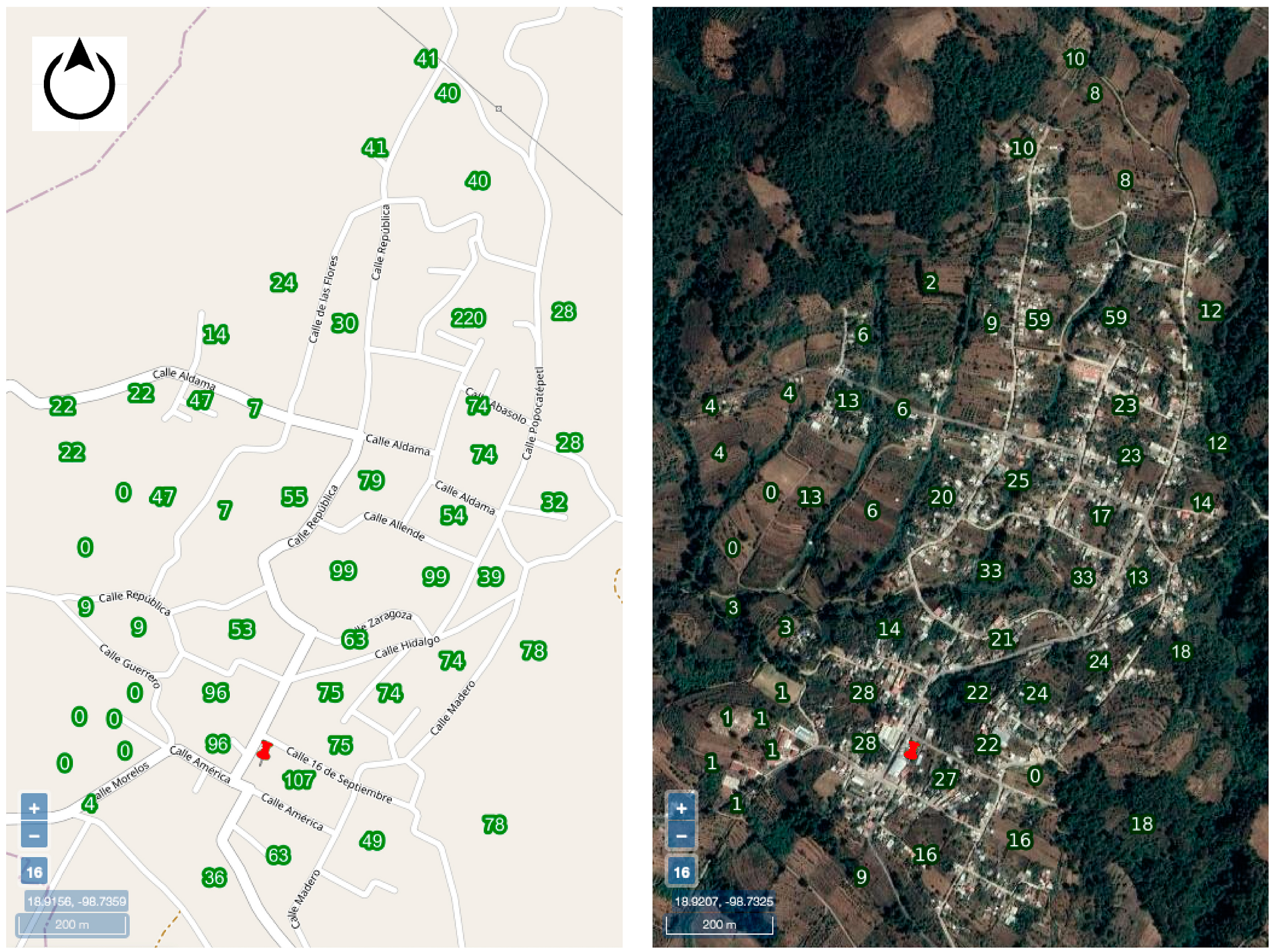
2.2. Exposure
2.3. Probability of Occurrence
2.4. Exposure-Based Risk Assessment
2.5. Failure Mode and Effect Analysis
- (a)
- Roads
- (b)
- Vehicles
- (c)
- PA and Radio Diffusion services
- (d)
- Provisional shelters
- (e)
- Electrical emergency supply
- (f)
- Clean water supply
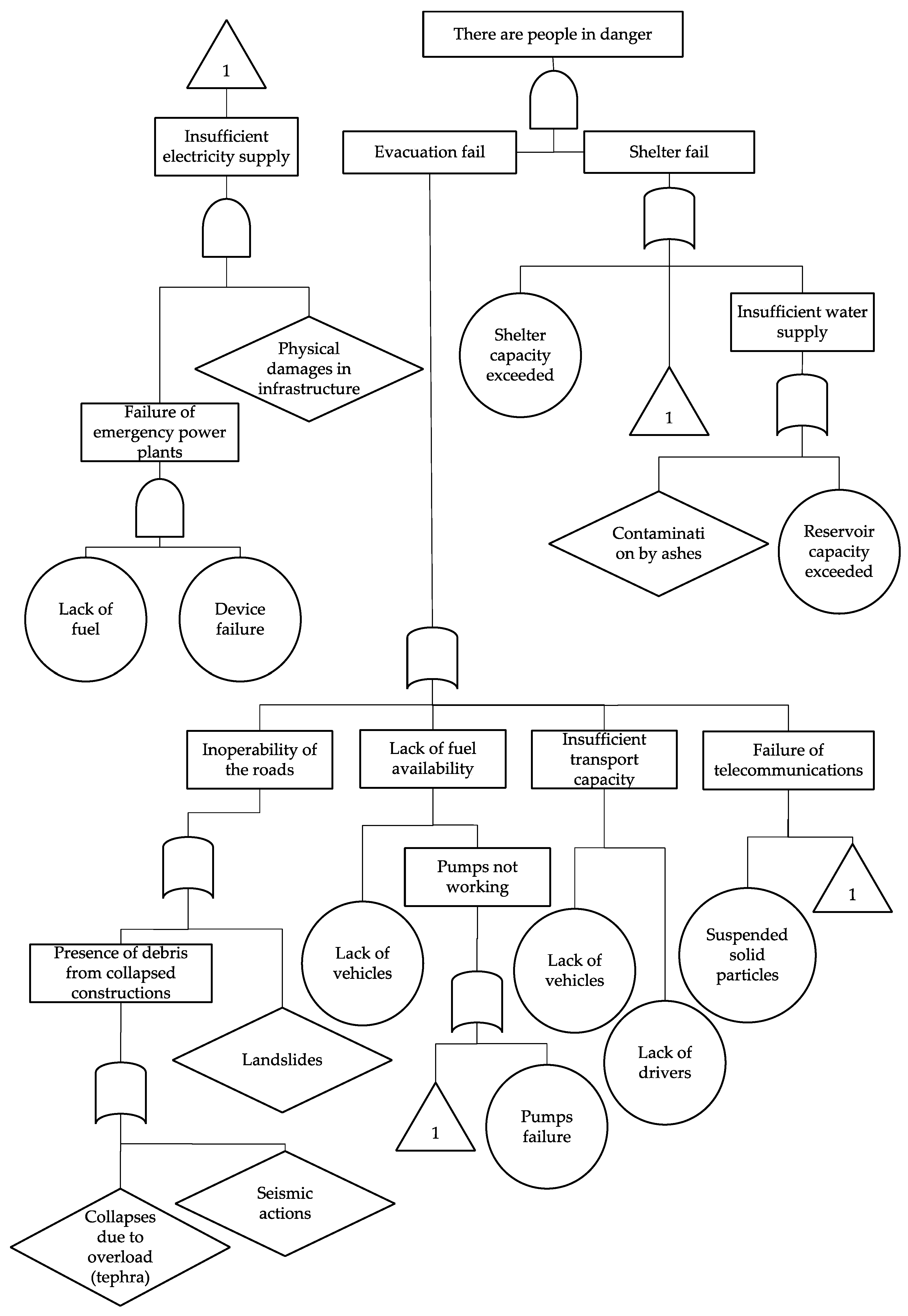
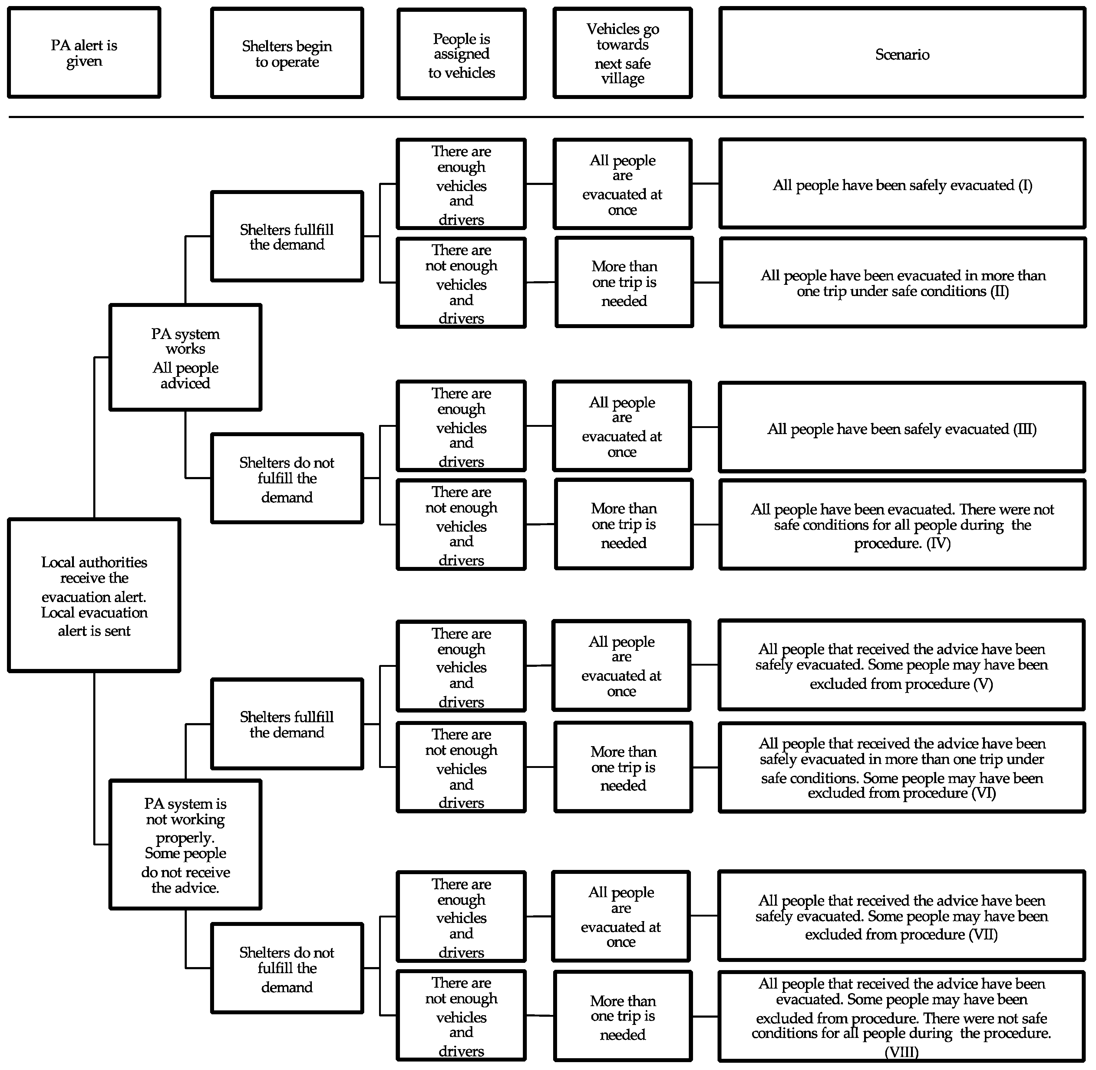
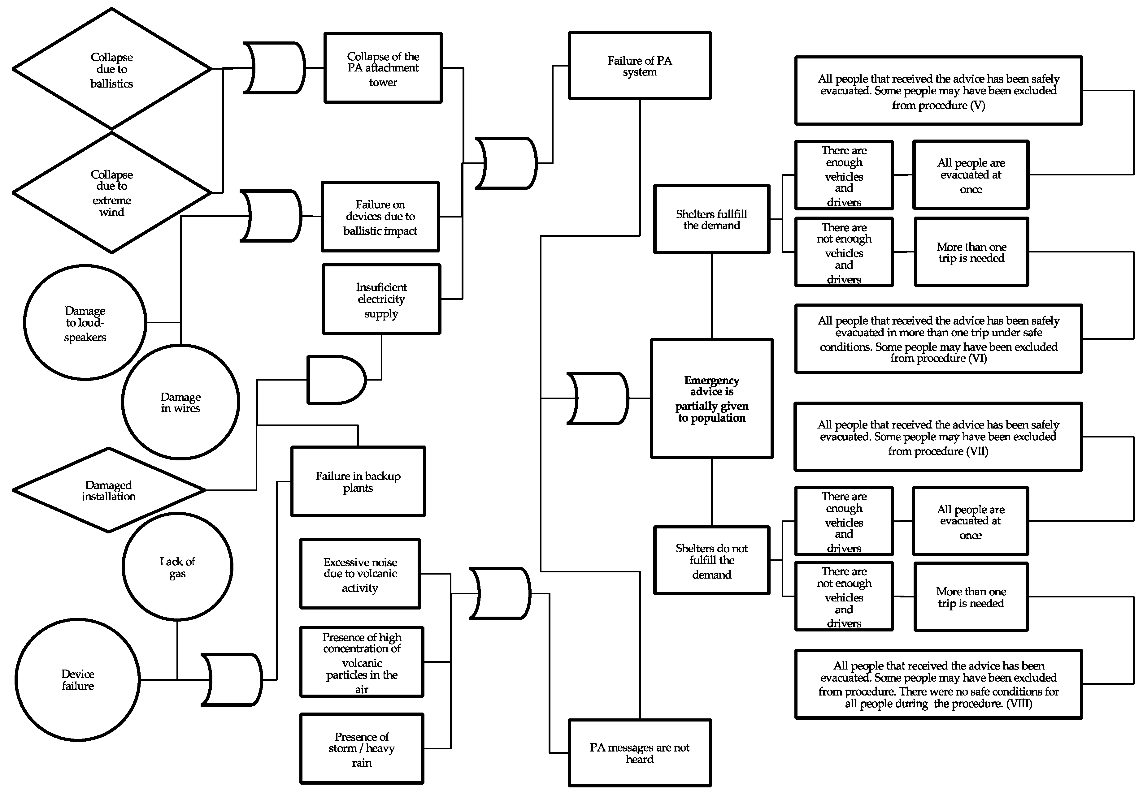
2.6. Failure and Event Tree Analysis
3. Conclusions
Author Contributions
Funding
Data Availability Statement
Conflicts of Interest
References
- Espinasa Pereña, R. Historia de la Actividad del Volcán Popocatépetl 17 Años de Erupciones, 1st ed.; Centro Nacional de Prevención de Desastres: Ciudad de México, Mexico, 2014. [Google Scholar]
- Donovan, A.; Ayala, I.A.; Eiser, J.R.; Sparks, R.S.J. Risk perception at a persistently active volcano: Warnings and trust at Popocatépetl volcano in Mexico, 2012–2014. Bull. Volcanol. 2018, 80, 47. [Google Scholar] [CrossRef] [Green Version]
- Secretaría de Desarrollo Social, Catálogo de Localidades, Sist. Apoyo Para La Planeación Del PDZP. 2015. Available online: http://www.microrregiones.gob.mx/catloc/contenido.aspx?refnac=170220003 (accessed on 5 December 2020).
- De La Cruz-Reyna, S.; Tilling, R.I. Scientific and public responses to the ongoing volcanic crisis at Popocatépetl Volcano, Mexico: Importance of an effective hazards-warning system. J. Volcanol. Geotherm. Res. 2008, 170, 121–134. [Google Scholar] [CrossRef]
- Jiménez, E.R. A vulnerability-based risk assessment of the threatened area surrounding Popocatépetl Volcano to support decision-making during a volcanic crisis. Geofis. Int. 2019, 58, 7–32. [Google Scholar]
- d’Albe, F. Objectives of volcanic monitoring and prediction. J. Geol. Soc. 2016, 136, 321–326. [Google Scholar]
- Stamatis, D.H. Failure Mode and Effect Analysis, 2nd ed.; William, A.T., Ed.; Quality Press: Milwaukee, WI, USA, 2003. [Google Scholar]
- Universidad Nacional Autónoma de México. Secretaría de Gobernación, Mapas de Peligros del Volcán Popocatépetl. 2016. Available online: http://www.geofisica.unam.mx/assets/mapasdepeligrosdelvolcanpopocatepetl.jpg (accessed on 5 December 2020).
- Del Martin Pozzo, W.C.A.L.; Alatorre Ibargüengoitia, M.; Arana Salinas, L.; Bonasia, R.; Capra Pedol, L.; Cassata, E.G.; Cortés Ramos, J.; Delgado Granados, H.; Ferrés López, M.D.; Fonseca Álvarez, R.; et al. Estudios Geológicos y Actualización del Mapa de Peligros del Volcán Popocatépetl; Memoria Técnica del Mapa de Peligro del Volcán: Ciudad de México, Mexico, 2017. [Google Scholar]
- Varios, Cartografía, Bibl. Digit. Volcán Popocatépetl. 2019. Available online: http://obum.zmcuernavaca.morelos.gob.mx/metadata/morelos/riesgos/popocatepetl/bibliotecapopocatepetl.htm (accessed on 5 December 2020).
- Bonadonna, C.; Biass, S.; Costa, A. Physical characterization of explosive volcanic eruptions based on tephra deposits: Propagation of uncertainties and sensitivity analysis. J. Volcanol. Geotherm. Res. 2015, 296, 80–100. [Google Scholar] [CrossRef]
- Fitzgerald, R.H.; Kennedy, B.M.; Wilson, T.M.; Leonard, G.S.; Tsunematsu, K.; Keys, H. The Communication and Risk Management of Volcanic Ballistic Hazards. Volcan. Debris Avalanches 2017, 121–147. [Google Scholar] [CrossRef] [Green Version]
- Brown, R.J.; Andrews, G.D.M. Deposits of Pyroclastic Density Currents. Encyclop. Volcano 2015, 631–648. [Google Scholar] [CrossRef]
- Vallance, J.W.; Iverson, R.M. Lahars and Their Deposits. Encyclop. Volcano 2015, 649–664. [Google Scholar] [CrossRef]
- Harris, A.J.; Rowland, S.K. Lava Flows and Rheology. Encyclop. Volcano 2015, 321–342. [Google Scholar] [CrossRef]
- Jenkins, S.F.; Spence, R.; Fonseca, J.F.; Solidum, R.; Wilson, T. Volcanic risk assessment: Quantifying physical vulnerability in the built environment. J. Volcanol. Geotherm. Res. 2014, 276, 105–120. [Google Scholar] [CrossRef]
- Sigurdsson, H.; Houghton, B.F.; McNutt, S.R.; Rymer, H.; Stix, J.; McBirney, A.R. Encyclopedia of Volcanoes. Phys. Today 2000, 53, 84–85. [Google Scholar] [CrossRef] [Green Version]
- Centro Nacional de Prevención de Desastres. Mapa de Peligros del Volcán Popocatépetl, Atlas Nac. Riesgos. 2020. Available online: http://www.atlasnacionalderiesgos.gob.mx/archivo/mapa-peligros-popo.html (accessed on 5 December 2020).
- Gregg, C.E.; Houghton, B.; Ewert, J.W. Volcano Warning Systems; Elsevier BV: Berlin, Germany, 2015; pp. 1173–1185. [Google Scholar]
- Centro Nacional de Prevención de Desastres. App Volcán Popocatépel, Atlas Nac. Riesgos. 2020. Available online: http://www.atlasnacionalderiesgos.gob.mx/apps/Popocatepetl/ (accessed on 26 October 2020).
- Newhall, C.G.; Self, S. The volcanic explosivity index (VEI) an estimate of explosive magnitude for historical volcanism. J. Geophys. Res. Space Phys. 1982, 87, 1231–1238. [Google Scholar] [CrossRef]
- Pyle, D.M. Sizes of Volcanic Eruptions. Encyclop. Volcano 2015, 257–264. [Google Scholar] [CrossRef]
- INEGI—Instituto Nacional de Estadística y Geografía. Mapa Digital de México. 2020. Available online: http://gaia.inegi.org.mx/mdm6/ (accessed on 26 October 2020).
- INEGI—Instituto Nacional de Estadística y Geografía. Espacio y datos de México. 2020. Available online: https://www.inegi.org.mx/app/mapa/espacioydatos/default.aspx (accessed on 26 October 2020).
- Wilson, T.M.; Stewart, C.; Sword-Daniels, V.; Leonard, G.S.; Johnston, D.M.; Cole, J.W.; Wardman, J.; Wilson, G.; Barnard, S.T. Volcanic ash impacts on critical infrastructure. Phys. Chem. Earth Parts A/B/C 2012, 45–46, 5–23. [Google Scholar] [CrossRef]
| Alert Level | Expected Scenarios | Actions Recommended to SINAPROC |
|---|---|---|
| Green: Normality | ||
| Phase 1 | –The volcano is quiet –Sporadic seismic signals | –Develop preparedness plans –Maintenance of monitoring devices –Keep pubic informed |
| Phase 2 | –Low-level seismic activity recorded only at nearest stations –Some fumarolic activity –Minor changes in temperature of fumaroles –Minor changes in the composition of spring waters that do not affect its quality for agricultural and public use significantly | –Increase monitoring –Review of emergency plans –Increase the dissemination of volcano information to the public –Evacuation routes meeting sites –Joint exercises and drills |
| Yellow: Alert | ||
| Phase 1 | –Increase of low-level local seismicity –Gas or steam fumaroles, and/or light tephra emissions –These manifestations may cause acidification of meteoric rain, and light tephra falls on towns surrounding the volcano. Some of them may pose a slight threat to air traffic | –Check availability of staff, equipment and vehicles required for evacuations. –Ask the SC to define criteria limiting access to the volcano –Issue warnings to the aircraft controllers. |
| Phase 2 VEI ≤ 2 | –Low to intermediate eruptive activity –Moderate explosions ejecting debris around the crater. –The explosions may eject tephra and produce light to moderate tephra falls on nearby towns, and farther cities if the wind is strong. –The tephra in the air may pose a threat to aircraft. –Low-level pyroclastic flows and mudflows (lahars) may develop without reaching populated areas. | –Keep shifts of emergency staff. –Increase the restricted access area around the volcano according to the recommendations of the SC. –Issue warnings to the air navigation systems –Anticipate a possible evacuation |
| Phase 3 VEI 2–3 | –Phreatic or magmatic eruptive activity of intermediate to high explosivity –Growth of lava domes, increased probability of magma ejection. –Possibility of explosions of increasing intensity ejecting hot debris to significant distances (several kilometres). –Conspicuous tephra fall on towns and cities. | –Prepare staff and equipment for shelter operation. –Implement specific measures in most vulnerable areas. –Start preventive measures against tephra and debris falls and lahars in highly vulnerable areas. (this may include some evacuations). |
| Red: Alarm | ||
| Phase 1 VEI 3–4 | –Possibility of more massive pyroclastic flows and lahars, not reaching populated areas. –Increased risk to aircraft and light effects on airports. –Intermediate to large explosive eruptions producing eruptive columns capable of reaching the stratosphere –The explosions may eject considerable amounts of tephra and fragments reaching the nearest towns –Production of large-scale pyroclastic flows and mudflows capable of reaching nearest towns and beyond –Important tephra falls in towns at intermediate distances capable of producing roof collapses. Significant tephra falls in large cities around the volcano –Serious threat to aircraft over large distances. Serious effects on airports | –Increase of restricted area around the volcano –Alert all systems of air traffic and navigation. –Selective evacuations according to criteria of the SC defined by the development and intensity of the eruption –Inform and promote about auto-evacuations in selected areas –Implement specific preventive measures against tephra and fragment falls in the regions near the volcano defined by the SC –Implement specific preventive measures against pyroclastic flows, surges and lahars in the regions defined by the SC –Implement preventive measures against moderate to intermediate tephra falls in metropolitan areas of proximal large cities –Implement emergency plans to protect and maintain communication lines and water and food supply –Nation-wide and international warnings to all aircraft and airports |
| Phase 2 VEI > 4 | –Large to an extreme eruption –Production of very large-scale volcanic clouds to the stratosphere. –Possibility of massive sector collapse of the volcano producing extensive debris avalanches –Massive pyroclastic flows –Massive lahars reaching distances beyond the extent of the Hazards Map –Devastation of the regions defined in the Hazard Map –Intense tephra falls, and fragment fall on metropolitan areas in cities within a radius exceeding 100 km –Maximum threat to all aircraft nation and continent-wide –Serious threat to airports nation-wide | –Extensive evacuations according to criteria of the SC defined by the evolution and intensity of the eruption –Inform and promote about voluntary evacuations over extended areas defined by the SC –Implement specific preventive measures against intense tephra and fragment falls in the regions defined by the SC –Implement specific preventive measures against massive debris flows, pyroclastic flows, surges and lahars in regions defined by the SC –Implement preventive measures against intermediate to large tephra and fragment falls in metropolitan areas of proximal large cities, including anti-panic measures for the total blockage of sunlight |
| Hazard | Relative Exposure of San Pedro Tlalmimilulpan y/x | Qualitative Probability of Occurrence According to Hazard Cartography [10] |
|---|---|---|
| Tephra | 0.67 | High |
| Projectiles | 0.00 | None |
| Pyroclastic density currents | 0.25 | Minor |
| Lahar or mudflows | 0.25 | Minor |
| Lava flows | 0.00 | None |
| Debris avalanches | The village is located in the ‘exposed’ territory. However, avalanches are events with a relatively small probability of occurrence in the context of all considered phenomena. Value has been set to y/x = 1. | |
| VEI Index | Bulk Tephra Volume | Plume Column Height | Qualitative Description | Stratospheric Injection | Mean Occurrence Rate (er/yr) | Probability of Occurrence within Any 20-Year Interval | Corresponding VTLAS Colour |
|---|---|---|---|---|---|---|---|
| 2 | <107 m3 | 1–5 km | Explosive | None | 13/500 | 0.410 | Yellow (2) |
| 3 | <108 m3 | 3–15 km | Possible | 3/500 | 0.113 | Yellow (2, 3) Red (1) | |
| 4 | <109 m3 | 10–25 km | Cataclysmic Paroxysmic | Certain | 2/1000 | 0.039 | Red (1) |
| 5 | <1010 m3 | >25 km | Certain | 10/15,000 | 0.013 | Red (2) | |
| 6 | <1011 m3 | >25 km | Certain | 10/40,000 | 0.005 | Red (2) |
| VTLAS Colour and Phase | Probability of Occurrence within a 20-Year Interval | Tephra Exposure: 0.67 | Pyroclastic Density Exposure: 0.25 | Lahars or Mudflows Exposure: 0.25 | Debris Avalanches Exposed |
|---|---|---|---|---|---|
| Yellow (1) | >0.410 | Light emissions | - | - | - |
| Yellow (2) | ≈0.410 | Light to moderate | Low-level, without reaching populated areas. | Around the crater | |
| Yellow (3) Evacuations may start | ≈0.410 | Conspicuous ashfall on towns and cities | Larger pyroclastic flows and lahars not reaching populated areas | - | |
| Red (1) Selective evacuations | 0.113–0.410 | Important ashfalls capable of producing roof collapses | Large-scale flows, capable of reaching nearest towns and beyond | - | |
| Red (2) Extensive evacuations | <0.113 | Intense ashfalls within a radius exceeding 100 km | Massive pyroclastic flows and lahars reaching distances beyond the extend of the Hazards Map | Extensive debris avalanches | |
| Scenario | People Advised | People Safety during the Procedure | Procedural Time | Success | Optimal Conditions |
|---|---|---|---|---|---|
| I | Optimal | Optimal | Optimal | Total | -All people have received advice during the first stages of evacuation. -All people have a place in a vehicle or a shelter during evacuation. -Procedural time is limited to one trip. |
| II | Optimal | Optimal | Non-optimal | Total | |
| III | Optimal | Non-optimal | Optimal | Total | |
| IV | Optimal | Non-optimal | Non-optimal | Partial | |
| V | Non-optimal | Optimal | Optimal | Partial | |
| VI | Non-optimal | Optimal | Non-optimal | Partial | |
| VII | Non-optimal | Non-optimal | Optimal | Partial | |
| VIII | Non-optimal | Non-optimal | Non-optimal | Partial |
Publisher’s Note: MDPI stays neutral with regard to jurisdictional claims in published maps and institutional affiliations. |
© 2021 by the authors. Licensee MDPI, Basel, Switzerland. This article is an open access article distributed under the terms and conditions of the Creative Commons Attribution (CC BY) license (http://creativecommons.org/licenses/by/4.0/).
Share and Cite
Ramírez Eudave, R.; Ferreira, T.M. Towards a Semi-Quantitative Approach for Assessing Evacuation Scenarios in the Context of Popocatépetl Volcano, México—The Case of San Pedro Tlalmimilulpan. GeoHazards 2021, 2, 1-16. https://doi.org/10.3390/geohazards2010001
Ramírez Eudave R, Ferreira TM. Towards a Semi-Quantitative Approach for Assessing Evacuation Scenarios in the Context of Popocatépetl Volcano, México—The Case of San Pedro Tlalmimilulpan. GeoHazards. 2021; 2(1):1-16. https://doi.org/10.3390/geohazards2010001
Chicago/Turabian StyleRamírez Eudave, Rafael, and Tiago Miguel Ferreira. 2021. "Towards a Semi-Quantitative Approach for Assessing Evacuation Scenarios in the Context of Popocatépetl Volcano, México—The Case of San Pedro Tlalmimilulpan" GeoHazards 2, no. 1: 1-16. https://doi.org/10.3390/geohazards2010001
APA StyleRamírez Eudave, R., & Ferreira, T. M. (2021). Towards a Semi-Quantitative Approach for Assessing Evacuation Scenarios in the Context of Popocatépetl Volcano, México—The Case of San Pedro Tlalmimilulpan. GeoHazards, 2(1), 1-16. https://doi.org/10.3390/geohazards2010001


