Abstract
Agriculture faces a dual challenge in the context of climate change, serving as both a significant contributor to greenhouse gas (GHG) emissions and a sector highly vulnerable to its impacts. Addressing this requires a transition toward climate-resilient agriculture (CRA). Emerging technologies, including geospatial tools (e.g., Geographic Information Systems (GISs) and remote sensing (RS)), as well as artificial intelligence (AI), offer promising methods to support this transition. However, their individual capabilities, limitations, and appropriate applications are not always well understood or clearly delineated in the literature. A common issue is the frequent overlap between GISs and RS, with many studies assessing GIS contributions while concurrently employing RS techniques, without explicitly distinguishing between the two (or vice versa). In this sense, the objective of this review is to conduct a critical analysis of the existing state of the art in terms of the distinct roles, limitations, and complementarities of GISs, RS, and AI in advancing CRA, guided by an original definition we propose for CRA (structured around three key dimensions and their corresponding targets). Furthermore, this review introduces a synthesis matrix that integrates both the individual contributions and the synergistic potential of these technologies. This synergy-focused matrix offers not just a summary, but a practical decision support matrix that could be used by researchers, practitioners, and policymakers in selecting the most appropriate technological configuration for their objectives in CRA-related work. Such support is increasingly needed, especially considering that RS and AI have experienced exponential growth in the past five years, while GISs, despite being the more established “big brother” among these technologies, remain underutilized and is often insufficiently understood in agricultural applications.
1. Introduction
Climate change, driven by intensified human activities, has emerged as one of the most pressing global challenges, with profound impacts on natural ecosystems, human societies, and economies [,]. As the global climate system becomes increasingly destabilized, agriculture finds itself uniquely positioned at the crossroads of this crisis. On one hand, agriculture significantly contributes to greenhouse gas (GHG; all the abbreviations used in this manuscript can be found in Table S1) emissions [,], accounting for approximately 22% of global emissions from the agriculture, forestry, and other land use sector in 2019 []. On the other hand, it is one of the most vulnerable sectors to the adverse effects of climate change, including rising temperatures, altered precipitation patterns, and increasingly frequent extreme weather events [,]. These climate-related stressors pose significant risks to agricultural productivity and, eventually, to global food security []. To meet the food demands of a growing population, large-scale intensified farming practices have been widely adopted. However, these practices have imposed considerable environmental pressures, such as soil degradation, water resource depletion, biodiversity loss, and pollution, caused by excessive chemical fertilizer inputs [].
In response, there is an urgent need to transition toward climate-resilient and sustainable agricultural practices. These approaches aim to maintain or enhance agricultural productivity while mitigating GHG emissions, reducing environmental degradation, and ensuring economic viability []. Resilience-focused strategies, in particular, are critical for enabling agricultural systems to adapt to and recover from climate-induced stresses, ensuring stability and productivity in the era of climate change [].
Recent advances in digital technologies, such as Geographic Information Systems (GISs), remote sensing (RS), and Artificial Intelligence (AI), have emerged as promising tools to support sustainable, climate-resilient agriculture (CRA). Specifically, GISs are specialized in processing, integrating, and analyzing spatial and non-spatial data. The applications of GISs in agriculture include crop yield estimation, soil fertility assessment, drought monitoring, precision agriculture (PA), pest and disease management, and optimizing fertilizer and weed control [,]. RS, on the other hand, captures environmental data using sensors on satellites, drones, or aircraft. These sensors analyze the electromagnetic spectrum to evaluate critical agricultural parameters, including crop health, soil moisture, and land cover changes []. Additionally, AI algorithms are able to analyze large datasets to predict risks, model outcomes, and recommend adaptive measures, further enhancing agricultural practices [].
Despite the significant advancements in these technologies, their integration into comprehensive frameworks remains underexplored. Several recent studies have consolidated and highlighted their individual applications in the agricultural sector [,,]. However, barriers such as limited expertise, high costs, and technical constraints often lead to their isolated use, limiting their capacity to address the complex and multifaceted challenges posed by climate change. These findings are consistent with those presented by Khanal et al. [], who noted that RS technologies are not yet fully implemented in agriculture due to knowledge gaps regarding their sufficiency, appropriateness, and technoeconomic feasibility. Similarly, for GIS-based methods, Radočaj et al. [] observed that their isolated use, particularly in land suitability assessments, often results in suboptimal outcomes due to accuracy gaps, subjectivity, and computational inefficiency. Among the most significant limitations in the use of AI are technological constraints, financial costs, infrastructural gaps, and the potential ethical concerns that may rise from their application [].
Although numerous reviews and research papers have been published in recent years, the extraordinary advancements in GISs, RS, and AI technologies, coupled with the accelerating impacts of climate change on agriculture, and the need to clear how these technologies could yield a higher efficiency in advancing CRA, highlight the necessity for a current and comprehensive understanding of their applications and integration. Addressing this need, the present review aims to (1) define CRA using an original and holistic framework; (2) evaluate the state of the art concerning the recent advances in geospatial technologies and AI in advancing CRA, including the individual contributions of GISs, RS, and AI, as well as the challenges associated with their implementation; (3) assess the transformative potential of their integration; and (4) propose future research directions. This critical narrative review synthesizes peer-reviewed articles, reviews, books, book chapters, and other authoritative sources, mostly published during the last decade. The literature was selected based on its relevance to the review’s objectives, the availability of the full text, and publication language (English). The search was conducted using major academic databases, including Web of Science Core Collection, Scopus, Google Scholar and ScienceDirect, to ensure a comprehensive understanding of recent advancements and applications. Keywords such as ‘Geographic Information Systems/GISs’, ‘remote sensing/RS’, ‘Artificial Intelligence/AI’, ‘climate-resilient agriculture’, ‘sustainable agriculture’ and ‘precision agriculture’ were used individually and in various combinations to ensure comprehensive coverage of the topic.
2. Recent Advances in Geospatial Technologies and AI for Climate-Resilient Agriculture
2.1. Defining Climate-Resilient Agriculture and Its Integration with Geospatial Technologies and AI
Despite its growing relevance amidst the stresses posed by climate change, the concept of CRA remains moderately explored and frequently misunderstood in scientific literature. This has led to inconsistencies in its application and interpretation. Therefore, it is essential to begin this section by clearly defining CRA, distinguishing it from sustainable agriculture (SA) and PA, and exploring the connections among these concepts.
CRA refers to a farming system designed to sustainably adapt to climate variability and change, mitigate GHG emissions, and enhance food security for growing populations [,]. According to the Food and Agriculture Organization (FAO), climate resilience is a cornerstone of climate risk management, representing the capacity of agricultural systems to anticipate, prepare for, adapt to, absorb, and recover from the impacts of climate change and extreme weather events. Strengthening this resilience requires implementing both short- and long-term mitigation and adaptation strategies while fostering the transparent and inclusive participation of diverse actors and stakeholders in decision-making processes []. Sarma et al. [] defined this concept succinctly and yet comprehensively, stating that CRA promotes “the integration of traditional knowledge with modern scientific advancements”.
The studies published so far define CRA and outline its principles, often linking it with SA, concepts which are still sometimes considered as synonyms and not properly differentiated. It is, therefore, of great importance to highlight that there is a clear difference between CRA and SA, although the two concepts are closely related and often overlap. As detailed in Table 1, CRA and SA share complementary goals but differ in their emphasis. While CRA focuses on strategies to adapt to and mitigate the impacts of climate change, SA encompasses broader goals of environmental, economic, and social sustainability.

Table 1.
Major objectives and key differences between climate-resilient agriculture, sustainable agriculture, and precision agriculture.
Precision agriculture is closely linked to both CRA and SA, acting as a bridge between the two. As detailed in Table 1, PA provides the data and tools needed to adapt farming systems to climate challenges (CRA) while ensuring that these adaptations remain environmentally sustainable and economically viable (SA). Thus, PA is not a standalone concept but a technology-driven approach [] that significantly enhances the effectiveness of both CRA and SA. It leverages advanced technologies such as GISs, RS, and AI to monitor, analyze, and optimize agricultural practices [,,]. These technologies enable more efficient land management, fostering climate resilience and long-term environmental stewardship.
An important contribution to the understanding of the CRA concept was made by Zong et al. [], who provided a comprehensive framework and assessment indicator system for CRA. Similarly, Sarma et al. [] offered a valuable synthesis of the strategies employed in CRA, which include diversifying crop varieties, PA, climate-smart agriculture, site-specific nutrient management, mulching, precise water management, implementing soil conservation methods, and many other indicators.
It is important to note that, in the scientific literature and research, an inclusive approach is sometimes used to simplify the overlap between the concepts of SA and CRA. The concept of climate-resilient sustainable agriculture (CRSA) has been sometimes introduced as a comprehensive strategy that combines sustainability with climate resilience, aiming to create agricultural systems that are both ecologically sound and adaptable to the challenges posed by a changing climate []. Finally, we should distinguish the two concepts from another emerging approach: climate-smart agriculture (CSA). While CSA shares similarities with both CRA and SA, there are differences in their scope and focus. CSA stands out for its integrated emphasis on productivity, adaptation, and mitigation.
Following our aim to provide a clear and comprehensive definition of CRA, we conclude with several final remarks regarding persistent gaps in how CRA is conceptualized. CRA is often discussed in the existing scientific literature in terms of its environmental and economic impacts, and less attention is paid to its social implications. However, resilience in agriculture is not solely about climate adaptation; it also depends on sustaining ecosystems and securing equitable livelihoods, thus necessitating a multi-dimensional approach. Several researchers highlighted this gap in previous studies. For example, Hellin et al. [] highlighted in the risk of maladaptation, where CRA interventions unintentionally reinforce existing vulnerabilities or exacerbate inequalities. The authors underlined that without careful implementation and a focus on social dynamics, CRA can inadvertently benefit the more powerful, leaving the most vulnerable at a disadvantage. Similarly, Pret et al. [] noted in a review article about farm resilience to climatic risk, that while many studies assess agricultural and economic dimensions of performance, socio-environmental aspects are often overlooked. The authors recommended comprehensive assessments that consider both the temporal variability of performance and socio-environmental dimensions to enhance farm resilience.
Considering all these gaps noted by previous studies, this review proposes an original definition of CRA based on three interrelated dimensions: climate, environmental, and socioeconomic (Figure 1). Further, for each dimension, we propose a set of representative targets, reflecting the essential areas where resilience must be pursued and achieved. This holistic approach highlights the interplay between climate adaptation, environmental sustainability, and socioeconomic resilience, thereby contributing to a more comprehensive and clearly defined set of CRA objectives.
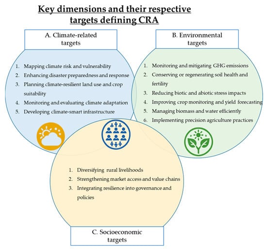
Figure 1.
Key dimensions defining climate-resilient agriculture (CRA) and their respective targets: (A)—climate-related targets; (B)—environmental targets; (C)—socioeconomic targets (Original).
At first glance, the climate and environmental dimensions may appear to overlap. However, they address distinct yet interconnected aspects of agricultural resilience.
The climate dimension focuses on long-term trends and variability in temperature, precipitation, and extreme weather events, which directly influence farming conditions. The specific targets falling within this dimension are (1) mapping climate risk and vulnerability (central to understanding how different regions, crops, or populations are exposed and sensitive to climate hazards); (2) enhancing disaster preparedness and response (supports preparedness and rapid response during extreme climate events like floods, droughts, or storms); (3) crop suitability and land use planning (helps adapt cropping systems to shifting climate zones and optimize land use under changing climatic conditions); (4) monitoring and evaluating climate adaptation strategies (critical for tracking the effectiveness of adaptation measures and improving resilience-building interventions); and (5) developing climate-smart infrastructure (involves designing resilient infrastructure, for example, irrigation, drainage, and storage that can withstand future climate stressors).
In contrast, the environmental dimension encompasses broader ecosystem factors such as reduced GHG emissions, soil health, water resources, biodiversity, and land degradation, all of which shape the sustainability and ecological foundations of resilient agricultural systems. The specific targets falling within this dimension are (1) monitoring and mitigating GHG emissions (tracks and reduces GHG outputs from agricultural practices, supporting climate regulation and promoting low-carbon farming systems); (2) conserving or regenerating soil health and fertility (core to SA as healthy soils improve resilience to drought, reduce erosion, and support nutrient cycles; enhances soil structure, organic matter, and nutrient cycling through regenerative and conservation practices, promoting long-term productivity and carbon sequestration); (3) reducing biotic and abiotic stress impacts (helps detect and respond to threats like pests, diseases, salinity, and heat stress, ensuring ecosystem balance); (4) improving crop monitoring and yield forecasting (essential for evaluating productivity trends in response to environmental factors and informing adaptive strategies); (5) managing biomass and water efficiently (critical for estimating ecosystem productivity, optimizing water use, and sustaining crop health under changing climates); and (6) implement precision agriculture practices (optimizes resource use and input efficiency through data-driven technologies, reducing environmental impact while maintaining high productivity).
The socioeconomic dimension further complements this framework by integrating factors such as market access, policy support, rural livelihoods, and social equity, which play an outstanding role in shaping farmers’ adaptive capacity and decision-making. The specific targets falling within this dimension are (1) diversifying rural livelihoods (supports income stability by promoting alternative income sources such as agri-tourism, agro-processing, or off-farm employment, reducing vulnerability to climate shocks); (2) strengthening market access and value chains (improves economic resilience by connecting farmers to stable markets, reducing post-harvest losses, and increasing the value of agricultural products); and (3) integrating resilience into governance and policies (mainstreams climate adaptation into agricultural planning and decision-making, ensuring long-term institutional support and resource allocation for resilient practices).
Assessing and implementing these interrelated dimensions of CRA can be a complex challenge, particularly due to the dynamic, spatial, and systemic nature of climate, environmental, and socioeconomic factors. In this context, the integration of emerging technologies, namely GISs, RS, and AI, becomes essential. When strategically applied, these tools provide the spatial, temporal, and predictive insights necessary to operationalize CRA.
Given the distinct contributions of geospatial technologies (namely GISs and RS) and AI in supporting CRA and by extension, facilitating PA and SA, the following three sub-sections will explore the specific individual roles each kind of technology plays in advancing CRA across these three dimensions and attaining their respective targets. For each technology, we provide a SWOT-style synthesis table, summarizing strengths and limitations in relation to the CRA dimensions and their specific targets. While the detailed discussion of shared limitations and risks has been consolidated into the third section of the manuscript to avoid redundancy, these tables retain technology-specific insights to help understand each tool’s unique contributions and challenges.
2.2. GIS Contribution to Advancing Climate-Resilient Agriculture: Current Trends and Existing Limitations
GISs are cornerstone technologies in modern agriculture, facilitating the integration, querying, visualization, and analysis of geographic data at various scales []. Etymologically, the term GIS is composed of three words: (1) “geographic” (adjective) = “relating to the natural features, population, industries, etc., of a region”, derived from the Greek word “geo” meaning “earth” []; (2) “information” (noun) = “facts or details about a situation, person, event, etc.”, originating from the Latin word “informare” meaning “to form or shape” []; and (3) “system” (noun) = “a group of things, pieces of equipment, etc., that are connected or work together”, derived from the Greek word “systema” meaning “an organized whole” []. Thus, a GIS refers to a system that integrates hardware, software, data, and people to collect, store, analyze, and visualize spatial or geographic information. Often referred to as the “brain” of PA, GISs provide essential tools and methods for efficient geospatial information management in agriculture [], which are key prerequisites for CRA.
From a technical point of view, a GIS operates as a spatial data management and analysis system, integrating diverse georeferenced datasets to uncover patterns, relationships, and trends in agricultural landscapes. An important aspect to note is that a GIS itself does not generate data but relies on external sources such as satellite imagery, RS data, aerial surveys, field sensor measurements, climate databases, and cadastral records. Its primary function is to process, analyze, and visualize these datasets to support decision-making. While GISs can derive new insights from existing spatial data (e.g., interpolated maps or predictive land-use models), their effectiveness is ultimately dependent on the quality, accuracy, and availability of external geospatial data sources.
In relation to GIS functions, mapping is often considered a core function of GISs in agriculture, but this perspective risks oversimplifying its role. Therefore, it is important to acknowledge that GISs are not merely tools for spatial visualization but comprehensive decision support systems that enables data integration, spatial analysis, and predictive modeling [,,]. Although mapping soil properties, water distribution, and climate risks provides a foundational spatial reference, the true value of GISs lie in their ability to synthesize complex datasets, combining historical trends, real-time field data, and environmental variables to guide adaptive management strategies. Without this analytical depth, static maps alone fail to capture the dynamic and site-specific nature of climate resilience.
As climate change intensifies, GIS technologies are increasingly employed to optimize agricultural practices, mitigate adverse impacts, and enhance the sustainability of farming systems [,]. However, despite the growing body of research on GIS applications in agriculture, their targeted use in advancing CRA as an integrated framework remains limited.
Several review and research articles have classified GIS applications in agriculture [,,]. However, to the best of our knowledge, existing classification systems are more fragmented, focusing primarily on broad categories based on specific functions or areas (e.g., climate risk mapping, crop health monitoring, or insect and pest control), often overlooking the integrated approach needed to address the interconnected challenges of climate change and sustainable development. Addressing this gap, the present paper introduces a thematic framework for structuring GIS applications in the context of CRA (Table 2), organized in the three interrelated dimensions of CRA (climate, environmental, and socioeconomic) and their respective targets. This framework aims to guide researchers, decision-makers, and agricultural stakeholders in understanding how GISs can contribute more holistically to building resilience in agriculture.
Table 2.
Key contributions of GISs in advancing CRA and their respective strengths and limitations.
A. Climate-related targets
- Mapping climate risk and vulnerability. GISs are extensively used to map climate risks, such as droughts, floods, heatwaves, and extreme weather events. Through risk assessment models, GISs integrate climate data, soil conditions, and land use patterns to pinpoint vulnerability hotspots. These insights help in prioritizing areas for intervention and developing site-specific adaptation strategies.
Several studies have employed this application so far in research. For example, Varela et al. [] demonstrated in a study how GISs enhance CRA by mapping climate risks and assessing farmland vulnerability in Agusan del Norte, Caraga Region, Philippines. The authors concluded that integrating GIS-based climate risk assessments with adaptive farming strategies is essential for improving agricultural resilience in the studied region. Similarly, Aziz et al. [] conducted research aiming to assess agricultural drought in Bangladesh by integrating meteorological drought data and soil water-holding capacity using GISs to identify drought-prone areas and inform policy for drought-tolerant crops. The study highlighted the regions more prone to agricultural drought, emphasizing the utility of GISs in evaluating spatially dynamic drought conditions and guiding effective agricultural strategies.
- 2.
- Enhancing disaster preparedness and response. GISs enhance early warning systems by tracking extreme weather events in real time, enabling timely disaster preparedness and mitigation measures. It also plays an important role in post-disaster assessments by estimating agricultural losses, guiding recovery efforts, and informing policy decisions related to disaster risk reduction and adaptation planning. These capabilities have been demonstrated in several studies. For example, research conducted by Guo et al. [] analyzed the spatiotemporal variation in natural disasters and their impact on grain losses in China from 1978 to 2014 using statistical techniques, social network analysis (SNA), and GIS tools. Their findings revealed a significant increase in natural disasters, particularly droughts and floods, highlighting the most affected regions in terms of severe grain losses. Based on these results, the study emphasized that prioritizing drought and flood prevention and mitigation strategies is of outstanding importance to safeguarding China’s future sustainability and food security.
- 3.
- Planning climate-resilient land use and crop suitability. GIS-based models are able to assess crop suitability under changing climatic conditions, helping farmers choose climate-resilient crops. By analyzing soil properties, temperature patterns, and precipitation trends, GISs support sustainable land use planning, ensuring agricultural activities align with environmental constraints and future climate scenarios [,].
A study conducted by Yohannes et al. [] utilized a GIS-based multi-criteria approach to assess land suitability for wheat and barley cultivation in the Andit Tid watershed, Ethiopia. Their findings revealed that while most of the watershed (77.42%) was moderately suitable for both crops, only a small portion (0.51%) was highly suitable, with limiting factors such as soil depth, texture, temperature, slope, and erosion hazard. The research concluded that current land use patterns often disregard suitability potential, emphasizing the urgent need for land use modifications to enhance agricultural productivity and sustainability in the region. Another study by Kahsay et al. [] pointed out the important contribution of GISs (along with fuzzy set models and analytical hierarchy process (AHP) methods) in assessing sorghum crop suitability considering soil, climate, and topographic factors. The study found that 30.54% of the area was moderately suitable, with slope, temperature, and soil properties as key limiting factors, emphasizing the need for better soil and water management to improve productivity.
- 4.
- Monitoring and evaluating climate adaptation. GISs provide a framework for tracking the effectiveness of CRA interventions over time. By analyzing changes in land use, crop productivity, and resource efficiency, GISs support the evaluation of different adaptation techniques. This enables continuous improvement of resilience strategies and informs evidence-based policymaking. So far, several studies have employed this application. An appropriate example is the study conducted by Seif-Ennasr et al. [], who aimed to assess land suitability, water demand, and crop season duration under climate change scenarios through a GIS-based multi-criteria analysis. The study projected a decline in highly suitable agricultural land and a shortening of the growing season, emphasizing the need for adaptive land use planning and efficient water management to sustain agricultural productivity.
- 5.
- Developing climate-smart infrastructure. GISs play a pivotal role in climate-smart infrastructure planning by enabling the analysis and visualization of spatial data, which is essential for designing agricultural infrastructure that is resilient to climate change. A study by Săvan et al. [] demonstrated the utility of GISs in this context, consolidating various ways they can be applied to support climate-resilient infrastructure development. Conducted in the Apuseni Mountains, Romania, the research assessed land use favorability under changing climate conditions using GISs, providing a framework for sustainable land management in flood-prone areas. Furthermore, the study examined how climate change influences land suitability categories, offering valuable insights for the strategic placement of soil conservation structures.
B. Environmental targets
- Monitoring and mitigating GHG emissions. GISs have been widely employed during the last ten years in research aiming to monitor and mitigate GHG emissions. The studies published so far highlighted its effectiveness in supporting the spatial identification of GHG emission hotspots from agricultural activities, enabling targeted interventions and improved land management strategies. An example is the research conducted by Ortiz-Gonazalo et al. [], who assessed GHG balances in smallholder crop-livestock systems in Central Kenya. The authors provided valuable insights into potential mitigation strategies through GIS-based analysis.
- Conserving or regenerating soil health and fertility. To date, several research and review papers have highlighted the usefulness of GISs in facilitating spatial mapping of soil properties, including pH, organic matter, nutrient levels, and salinity, to support precision soil management and ultimately, climate resilience in agriculture. For example, Rezaei et al. [] explored the integration of the Global Positioning System (GPS) and GISs for precision nutrient application. Their findings highlighted the important contribution of these technologies in enhancing the accuracy of nutrient application and minimizing input wastage.
- Reducing biotic and abiotic stress impacts. GISs were increasingly used to detect biotic stresses (pests, diseases, invasive species) and abiotic stress factors (heat waves, droughts, salinity) by analyzing vegetation health indices. Spatial data integration with weather models supports predictive risk mapping, enabling early intervention and adaptive management [,]. A relevant example is the study by Bolo and Mpoeleng [], which employed GISs to map the distribution of quelea bird pests in the Central District of Botswana farmlands. Through overlay and buffer analysis, GISs enabled the identification of pest hotspots and habitat patterns, providing valuable geospatial information to support targeted pest management interventions.
- Improving crop monitoring and yield forecasting. GISs have been successfully used for tracking crop health, growth stages, and stress conditions in real time. Research has highlighted the usefulness of GISs in forecasting crop yields by analyzing past trends, climatic conditions, and soil health data, ultimately optimizing harvest timing and resource allocation, which improves overall productivity and resilience. Kadiyala et al. [] conducted a study in India aiming to analyze the spatial variability of climate change impacts on groundnut yields. By integrating GISs with a crop simulation model, the authors of the research managed to develop a web-based decision support tool to assess the effects of different climate change scenarios and adaptation strategies. The study highlights how GISs can assist in making informed decisions about soil management and crop suitability, thereby contributing to more resilient agricultural practices in the face of climate change.
- Managing biomass and water efficiently. GISs proved to be extremely useful for monitoring biomass productivity, supporting carbon sequestration studies, and enhancing climate-smart agricultural practices. To date, several studies have already employed these capabilities of GISs. For example, Guerrero et al. [] assessed the potential of banana residual biomass in El Oro, Ecuador, for bioenergy applications using GISs. Their study highlighted the significant biomass potential for bioenergy production and identified suitable locations for biomass processing facilities.
Furthermore, GISs have also been extensively used for assessing evapotranspiration rates, optimizing irrigation planning, and ensuring sustainable water management. By mapping water resources, soil moisture levels, and watershed dynamics, GISs already proved to be a real aid in reducing climate-related water stress in agriculture. An important contribution to the application of GISs in water resource management was made by El Behairy et al. []. Their study assessed water suitability in the West Nile Delta, Egypt, by integrating irrigation water quality (IWQ) with GISs. The major indicators employed included salinity, permeability hazards, and ion toxicity. Their findings revealed the varying suitability of water resources for irrigation and highlighted the presence of significant heavy metal contamination in the samples.
- Implementing precision agriculture practices. GISs significantly contribute to the implementation of PA by providing spatial analysis tools that support precise, efficient, and sustainable farm management. One of the primary contributions of GISs in PA is its ability to generate detailed, multi-layered maps that represent various field attributes such as soil composition, moisture levels, and crop health. For example, Suleymanov et al. [] demonstrated how GISs can be utilized to map the spatial distribution of soil nutrients by analyzing topographic features. This approach allows for the precise identification of variability within a field, enabling farmers to implement targeted fertilizer applications and optimize resource use.
Moreover, the integration of GISs into PA has been shown to enhance both farm profitability and sustainability. A significant contribution to this field was presented in the systematic review by Mathenge et al. [], which synthesizes evidence on GIS applications that facilitate informed policy and practice, particularly in low- and middle-income countries. Their findings highlight the transformative potential of GISs in agricultural management, demonstrating their role in improving efficiency and resilience across diverse farming systems. Furthermore, a study by Giannarakis et al. [] introduces a data-driven framework that leverages Earth observations and causal machine learning to assess agricultural land suitability. By integrating GISs with advanced analytical methods, the study demonstrates how spatial data can guide decision-making for sustainable and resilient agriculture in the context of climate change. Another important contribution to the understanding of how GISs can contribute to PA implementation was made by Sharma et al. []. The study proposed a “Big GIS Analytics” framework designed to effectively manage and analyze extensive spatial data within the agricultural sector. By synthesizing findings from 120 research papers, the study highlights the transformative potential of big GIS data applications in addressing challenges such as shrinking land sizes, increasing demand for natural resources, and environmental concerns.
C. Socioeconomic targets
- 2.
- Diversifying rural livelihoods. GISs have been effectively used to assess livelihood diversification by identifying spatial opportunities for alternative income sources—such as ecotourism, agroforestry, or non-timber forest products—based on local environmental and socioeconomic conditions. For example, Bahadur [] conducted research in Nepal demonstrating how GIS-based analysis of land quality and market access revealed key factors influencing farm income, supporting the design of location-specific development interventions.
- 3.
- Strengthening market access and value chains. GISs have been employed for analyzing and optimizing supply chains by mapping infrastructure, production zones, and market access routes. Bosona et al. [] conducted research aiming to evaluate the performance of an integrated food distribution network (IFDN) in Sweden using GIS tools to optimize location and routing decisions. Their findings demonstrated significant improvements in logistical efficiency, transport time, and environmental sustainability, enhancing the competitiveness of local food producers and strengthening their market access.
- 4.
- Integrating resilience into governance and policies. GISs facilitate the spatial analysis of socioeconomic factors such as population density, market accessibility, land tenure, and farming income, helping policymakers understand how these elements influence agricultural productivity and climate adaptation capacity. Research by Tulloch et al. [] explored the use of GISs to enhance farmland preservation strategies. The study proved that by integrating spatial data on land use, soil quality, and development pressure, policymakers could identify priority areas for conservation, thereby improving the effectiveness of preservation efforts.
- 5.
- Integrating resilience into governance and policies requires evidence-based decision-making frameworks that guide the allocation of resources and the design of effective adaptation measures. One such framework is cost–benefit analysis (CBA), a vital tool that could assist policymakers and farmers in making informed decisions that enhance resilience to climate change while ensuring economic viability. To this end, GISs support economic assessments of different CRA strategies by mapping regions with varying adaptation practices and analyzing their economic viability. A study by Balana et al. [] employed GISs to evaluate the cost-effectiveness of soil and water conservation practices in Ethiopia. The researchers mapped spatial variations in soil degradation and rainfall distribution, integrating this data with economic models to estimate the net benefits of different conservation strategies. Their findings indicated that site-specific adaptation measures, such as terracing and agroforestry, significantly improved yields and economic returns for farmers.
2.3. RS Contribution to Advancing Climate-Resilient Agriculture: Current Trends and Existing Limitations
RS is a valuable emerging technology that enables the collection, processing, and interpretation of data from the Earth’s surface without direct contact. Etymologically, the term “remote sensing” is derived from two key words: (1) “remote” (adjective) = “far away from places where other people live; isolated” [], and (2) “sensing” (from the verb “sense”) = “to become aware of something even though you cannot see it, hear it, etc.” []. This combination of “remote” and “sensing” reflects the technology’s ability to detect and analyze environmental conditions at a distance. To this end, RS functions primarily as a diagnostic tool in agriculture [], providing large-scale, high-resolution, and real-time monitoring of biophysical and climatic parameters. Specifically, in agriculture, RS contributes with valuable insights into crop health, soil moisture, weather patterns, and land use changes [,,], all of which are essential for building climate-resilient agricultural systems.
From a technical point of view, RS operates through the acquisition of data via sensors mounted on satellites, aircraft, or unmanned aerial vehicles (UAVs). These sensors capture electromagnetic radiation/reflectance of light at specific wavelengths reflected or emitted by Earth’s surfaces, data which is then processed and analyzed for various applications. Key components for utilizing RS in agriculture include satellite platforms (e.g., Landsat, Maxar Technologies, MODIS—Moderate-Resolution Imaging Spectroradiometer, Planet Labs, Sentinel) and aerial systems (UAVs equipped with multispectral or hyperspectral sensors). Several satellite imagery sources are available free of charge, such as MODIS and Landsat from NASA, and Sentinel from the European Space Agency, while others, including those from Maxar Technologies and Planet Labs, require paid access. Although both free and commercial satellite data offer distinct advantages and limitations, the choice between them should be guided by the specific objectives, resources, and budget of the agricultural user. Free data are invaluable for many research and application use cases, whereas commercial satellites provide additional flexibility, higher-resolution imagery, and tailored solutions [].
RS relies on different types of sensors and spectral bands: passive sensors detect reflected sunlight, while active sensors, such as synthetic aperture radar (SAR), emit signals and measure their return to assess surface characteristics. Vegetation indices (VIs) derived from satellites and UAVs, such as NDVI (Normalized Difference Vegetation Index; NDVI = (NIR − Red)/(NIR + Red)), EVI (Enhanced Vegetation Index; EVI = 2.5 (NIR − RED)/(NIR + 6RED − 7.5BLUE + 1)), and SAVI (Soil Adjusted Vegetation Index; SAVI = [(NIR − RED)/(NIR + RED + L)] × 1 + L), are widely used in agricultural studies, being often regarded as the most important components of this technology []. Further mathematical details can be found in our earlier study [].
However, it is important to mention that other spectral analysis methods, including thermal imaging and radar-based moisture assessment, could deliver important insights on soil conditions, evapotranspiration, and land–atmosphere interactions. For example, thermal infrared sensing monitors plant water stress by detecting temperature variations in crop canopies, while SAR data is particularly valuable for estimating soil moisture, even under cloud cover. Research has shown that integrating data from multiple sources enhances accuracy and enables the creation of comprehensive datasets for agricultural studies [,,]. Despite these advantages, studies leveraging multi-source data remain limited [].
Following the structure used in the previous section on GISs contributions to advancing CRA, we further continue with the presentation of the key-contributions of RS applications in advancing CRA (Table 3). As such, we used the similar thematic framework for organizing RS applications structured around the three key dimensions of CRA (climate, environmental, and socioeconomic) and their specific targets. We must acknowledge that the existing studies have categorized RS tools based on their technical features or sectoral uses in agriculture and climate adaptation, but, to the best of our knowledge, no framework to date directly aligns RS applications with the core dimensions and goals of CRA following a similar approach.
Table 3.
Key contributions of RS in advancing CRA and their respective strengths and limitations.
A. Climate-related applications
- Mapping climate risk and vulnerability. RS plays a central role in climate risk management because it provides the spatial and temporal data (such as land surface temperature, precipitation anomalies, vegetation stress, and soil moisture) needed to enable the identification of climate-sensitive areas and vulnerable agricultural zones. Among the most widely applied RS techniques were drought monitoring, temperature assessment, and precipitation pattern analysis. Satellite-based indices such as the NDVI, Temperature Condition Index (TCI), Vegetation Condition Index (VCI), Vegetation Health Index (VHI) and Land Surface Temperature (LST) were extensively used to detect drought stress in crops. Kloos et al. [] conducted research in Germany aiming to correlate the NDVI and LST derived from MODIS with land cover and altitude, and to evaluate the effectiveness of several drought indices (TCI, VCI and VHI) by linking them to soil moisture and agricultural yield anomalies. The authors found that NDVI and LST were negatively correlated, indicating that water is the primary limiting factor for vegetation growth. Furthermore, their results showed that both TCI and VHI strongly correlate with soil moisture and yield anomalies, demonstrating their potential for detecting agricultural drought in Bavaria.
- Enhancing disaster preparedness and response. RS allows real-time and historical monitoring of extreme events (e.g., floods, droughts, heatwaves), contributing to early warning systems and rapid post-disaster assessments to support timely interventions and recovery strategies. Thus, RS proved to be extremely useful in advancing CRA as a support for decision-making before, during, and after climate-related events. An important contribution to this research topic was delivered by Tran et al. [], who conducted a study in the Vietnamese Mekong Delta, addressing critical concerns over annual floods and altered hydrological regimes. The research aimed to develop an algorithm (called Otsu) based on Sentinel-1 synthetic aperture radar imagery (specifically its cross-polarized VH data) to automatically extract surface water and monitor flood extents in near real time. Their findings revealed that the dynamic Otsu thresholding algorithm produced surface water maps that strongly corresponded with Sentinel-2 observations, and when combined with change detection time series analysis, it enabled accurate temporal flood mapping (with high statistical agreement in river areas).
- Planning climate-resilient land use and crop suitability. Crop suitability and land use planning are critical applications of RS in CRA, involving the evaluation of environmental conditions to determine optimal cropping patterns (the match between crop requirements and local conditions, e.g., soil quality and climate) and sustainable land allocation (allocation of land resources to maximize productivity and environmental sustainability). Up to date, several studies have employed RS applications in this topic. A relevant example is the study conducted by Nabiollahi et al. [], who conducted research in Iran aimed to improve land suitability assessment for wheat cultivation by integrating RS data, terrain information, and geomorphological variables with advanced analytical tools. The study proposed a replicable, data-driven framework that enhances the accuracy of land evaluation and supports sustainable, climate-resilient land use planning. Another important contribution to this topic was provided by Nong et al. [], who conducted a study in the Tien Hai district, Vietnam. The researchers analyzed land use changes over a 15-year period, and showed significant shifts from cropland to aquaculture and forest land.
- Monitoring and evaluating climate adaptation. RS facilitates the monitoring of adaptive interventions (e.g., changes in land use, irrigation practices, vegetation cover), offering a consistent and scalable method to evaluate their effectiveness over time and space. These capabilities are demonstrated through several studies published so far on this topic. A relevant example is the study conducted by Abah and Petja [], who employed RS to evaluate land suitability for yam, cassava, and rice cultivation in Nigeria’s Lower River Benue Basin. The study integrated satellite imagery, soil data, and climate variables to produce suitability maps. The results revealed that the area is moderately suitable for these crops, with rice showing the highest suitability.
- Developing climate-smart infrastructure. RS supports the siting, planning, and monitoring of resilient infrastructure such as irrigation systems, storage facilities, and transport networks by providing topographical, hydrological, and land use data critical for design and risk reduction. An important contribution to this topic was made by Alvino and Marino [], who, in their review, analyzed the most significant applications of RS for monitoring soil and crop water status for irrigation purposes, highlighting both the advantages and limitations.
B. Environmental applications
- Monitoring and mitigating GHG emissions. RS facilitates the monitoring of GHG emissions by providing accurate data on land use changes and forest cover. An example is the research conducted by Turner et al. [], focused on mapping nitrous oxide (N2O) emissions in a 15.6-hectare cornfield in southern Minnesota. Researchers collected static chamber measurements and soil samples over a 42-day period following nitrogen fertilizer application. They employed geostatistical modeling techniques to resolve N2O emissions at a high spatial resolution of 1 m, identifying emission hotspots that accounted for 36% of field-scale emissions despite representing only 21% of the total field area. The study highlighted that variations in elevation led to predictable hotspot locations prone to nutrient and moisture accumulation.
- Conserving or regenerating soil health and fertility. High-resolution multispectral imagery from UAVs, combined with machine learning algorithms, has proven effective in assessing soil fertility. These applications were employed in several studies conducted so far. An example is the study by Enriquez et al. [], who utilized this approach in Central Peru to monitor soil nutrient levels, enabling precise fertilization practices and promoting sustainable soil management.
- Reducing biotic and abiotic stress impacts. RS technologies, particularly hyperspectral imaging, have been employed to detect and differentiate between various crop stresses. For example, a study by Goswami et al. [] employed RS (UAV) to rapidly identify frost-induced abiotic stress in maize crops. By analyzing spectral data, the researchers were able to detect stress areas within the field, enabling timely interventions to mitigate yield losses.
- Improving crop monitoring and yield forecasting. RS provides continuous monitoring of crop health and development, essential for yield forecasting. To date, numerous studies have employed the capabilities of RS. A great contribution was delivered by Dimov et al. []. The authors used Sentinel-2 satellite data to forecast sugarcane yield in Ethiopia, by integrating multi-temporal VIs, phenological metrics, and spatiotemporal variables within a Random Forest (RF) model. The research demonstrated high predictive accuracy and highlighted the value of phenological features for transferable yield models, supporting adaptive crop monitoring in climate-vulnerable regions.
- Managing biomass and water efficiently. RS plays an important role in managing biomass and water resources efficiently by providing continuous, large-scale, and timely data on vegetation health, crop growth, and soil moisture conditions. Satellite-derived indices such as NDVI and EVI are commonly used to estimate crop biomass and monitor vegetation dynamics, enabling farmers and planners to assess plant vigor and make informed irrigation decisions. Tamás et al. [] employed RS to develop a method for estimating drought-related yield losses and converting between different types of drought indices (meteorological, agricultural, and hydrological), based on spectral vegetation data. By comparing RS-derived spectral indicators with field measurements, the study demonstrated strong congruency, enabling early warning of drought impacts, supporting water-efficient land use planning at the river basin scale.
- Implementing precision agriculture practices. RS technologies are central to PA, enabling variable rate applications of inputs like fertilizers and pesticides. Multiple research and review articles demonstrated these capabilities, which collectively comprise a substantial share of the RS-related agricultural research to date [,,]. Segarra et al. [] made a great contribution to this research topic. The authors highlighted in a comprehensive review how the Sentinel-2 A + B twin satellite constellation (with its high spatial, temporal, and spectral resolution, combined with open access data policies) has significantly advanced RS applications in agriculture.
C. Socioeconomic applications
- Diversifying rural livelihoods. RS facilitates the diversification of rural livelihoods by providing critical data on land use, vegetation health, and resource availability. An important contribution to this research topic was delivered by Asfaw et al. [] employed RS data to assess how livelihood diversification strategies implemented in Malwi impact vulnerability to poverty, enabling targeted interventions to enhance resilience.
- Strengthening market access and value chains. RS enhances market access and value chain efficiency by offering real-time information on crop conditions, yield forecasts, and logistical planning. A World Bank study highlighted that integrating satellite and sensor data into agricultural supply chains can lead to a 20% increase in farmers’ income by optimizing resource allocation and minimizing losses [].
- Integrating resilience into governance and policies. RS supports the integration of resilience into governance and policymaking by providing comprehensive data for informed decision-making. The study by Łągiewska et al. [] exemplifies how RS-based drought monitoring and spatial analysis can inform policy and governance strategies to enhance regional climate resilience. By combining long-term satellite data, Copernicus High-Resolution Layers, and multi-criteria decision analysis, it identifies critical intervention areas, guiding effective drought mitigation policies at the local governance level.
2.4. AI Contribution to Advancing Climate-Resilient Agriculture: Current Trends and Existing Limitations
Although AI is widely recognized and increasingly integrated across sectors worldwide, there is still no universally accepted definition of the concept []. Etymologically, the term “artificial intelligence” is derived from two key words: (1) “artificial” (adjective) = “made or produced to copy something natural; not real” [], and (2) “intelligence” (noun) = “the ability to learn, understand and think in a logical way about things; the ability to do this well” []. This combination of “artificial” and “intelligence” reflects the technology’s core objective of replicating human cognitive functions through machine-based systems. Thus, in a simplest formulation, AI refers to the simulation of human intelligence by machines, particularly computer systems capable of learning, reasoning, and decision-making. In this article, we define AI as the field of computer science dedicated to creating systems capable of performing tasks that typically require human intelligence, such as learning, reasoning, problem-solving, and pattern recognition.
In agriculture, AI plays an increasingly vital role by enabling systems to autonomously analyze vast datasets, recognize patterns, and provide predictive insights that inform real-time decision-making. So far, many researchers have highlighted the immense potential of AI to reshape the future of agriculture through its transformative role in advancing adaptive, climate-resilient farm management [,]. Specifically, in agriculture, AI contributes with valuable capabilities such as crop yield forecasting, weed and disease detection, precision irrigation planning, livestock behavior analysis and many other applications [,,], all of which support more efficient, informed, and adaptive farm management practices.
From a technical point of view, AI systems in agriculture typically function through machine learning (ML) and deep learning (DL) algorithms trained on diverse datasets, including satellite imagery, sensor data, weather records, and crop performance statistics. These algorithms learn to detect anomalies (e.g., pest infestations, nutrient deficiencies), forecast yields, predict drought events, or even prescribe optimal irrigation or fertilization strategies [,]. Among DL architectures, Convolutional Neural Networks (CNNs) are extensively used for analyzing spatial patterns in remote sensing imagery, supporting applications like crop type classification, biomass estimation, and stress detection. Recurrent Neural Networks (RNNs), particularly Long Short-Term Memory (LSTM) models, excel in handling temporal sequences, making them suitable for time-series analysis of climate data, phenological monitoring, and seasonal forecasting tasks in agriculture.
AI workflows require a structured pipeline involving data pre-processing, model training, validation, and deployment, often supported by high-performance computing resources and cloud-based analytics platforms (e.g., Google Earth Engine, Microsoft AI for Earth, AWS).
To complement the analytical frameworks used for GISs and RS, we present further an integrated overview of AI’s contributions to advancing CRA (Table 4), structured around the three key dimensions of CRA introduced at the beginning of this section: climate, environmental, and socioeconomic, and their specific targets.
Table 4.
Key contributions of AI in advancing CRA and their respective strengths and limitations.
A. Climate-related applications
- Mapping climate risk and vulnerability. AI has been used in mapping climate risk and vulnerability in several studies conducted so far. Zennaro et al. [] provided a valuable review on this topic, highlighting that a significant increase in ML applications within climate change risk analysis was observed starting from 2015, with an exponential increase in publications from 35 to 600 per year by 2020. The same article pointed out that the topic of agriculture ranked fourth among the top ten disciplines contributing to this body of research, reflecting a growing interest in spatial risk analysis within agroecosystems. However, this also suggests that the integration of AI in agricultural vulnerability mapping is still emerging compared to fields like urban studies or meteorology. Furthermore, these findings were complemented by Espinel et al. [], who showed that approximately 50% of studies focused on broader agricultural landscapes and forests, while 25% targeted hydrographic basins and another 25% investigated individual crop systems. A notable example is the study by You et al. [], who applied a deep learning CNN to predict global crop yields under varying climate scenarios using RS data and meteorological variables. Their approach enabled spatially explicit vulnerability assessments, identifying high-risk zones where yield losses due to climate extremes were most likely.
- Enhancing disaster preparedness and response. AI technologies have increasingly demonstrated their potential to advance disaster preparedness and response strategies in agriculture. Over the past decade, research has pointed out that ML and DL models can improve the accuracy and timeliness of early warning systems, particularly for extreme weather events such as floods, droughts, and heatwaves. For example, Hammad et al. [] conducted a study focusing on the Upper Indus Basin, where various AI techniques, including artificial neural networks (ANNs) and Support Vector Machines (SVMs), were applied to predict rainfall patterns with improved accuracy. The research pointed out that this type of predictive modeling can support timely decision-making and risk mitigation strategies for local farming communities. Moreover, Khadr [] applied a Hidden Markov Model to forecast meteorological drought in the Upper Blue Nile River Basin in Ethiopia. Their study highlighted how AI can support proactive planning by improving the lead time and accuracy of drought prediction. Such predictive capacities are extremely important for developing CRA practices and disaster response mechanisms in data-scarce or climate-vulnerable regions. In addition to forecasting, recent developments in explainable AI, such as those explored by Hrast Essenfelder et al. [], offer transparent tools for disaster risk assessment and communication, improving stakeholder trust and actionable understanding.
- Planning climate-resilient land use and crop suitability. AI-based approaches are increasingly applied in land use and crop suitability, especially in the context of climate resilience. A relevant study was conducted by Taghizadeh-Mehrjardi et al. [], who demonstrated in research that ML models, when used for land suitability assessment for wheat and barley, outperformed traditional methods in accuracy. The study found that ML-based maps are able to provide more precise predictions for semi-arid regions, where data is often scarce. Furthermore, Mgohele et al. [] applied a hybrid approach combining the Analytical Hierarchy Process (AHP) and RF models to assess land suitability for sisal production in Tanzania. The findings revealed that the RF model demonstrated strong predictive accuracy for soil property suitability classes, with Kappa values ranging from 0.45 to 0.85.
- Monitoring and evaluating climate adaptation. The integration of AI into agricultural monitoring systems has enhanced the capacity to assess and refine climate adaptation strategies. Wang et al. [] proved these capabilities of AI in research by applying reinforcement learning (deep Q-learning with RNNs) within a POMDP framework to optimize nitrogen use and irrigation under climate uncertainty. By integrating a crop simulator, machine learning-based N2O emission prediction, and stochastic weather modeling, their AI system improved yield while reducing emissions. Similarly, Temraz et al. [] enhanced a case-based reasoning (PBI-CBR) system for sustainable dairy farming by integrating counterfactual data augmentation to improve grass growth prediction under climate disruption. Using explainable AI techniques, the system’s accuracy increased during extreme events, such as the 2018 drought, demonstrating improved adaptability to climate-induced variability.
- Developing climate-smart infrastructure. AI could play an emerging role in optimizing infrastructure critical for CRA. Still, we must note that the research employing this AI’s capabilities are scarce. A recent study by González Perea et al. [] demonstrated how AI can enhance the design and efficiency of irrigation systems by accounting for both environmental and behavioral variability. The research developed a hybrid model combining artificial neural networks, fuzzy logic, and genetic algorithms to predict farm-level irrigation water use in southwest Spain. By accurately forecasting farmer behavior and irrigation depth for key crops like rice, maize, and tomato, their AI approach improves water allocation planning, supporting the development of adaptive and efficient irrigation infrastructure.
B. Environmental applications
- Monitoring and mitigating GHG emissions. AI has been employed in multiple studies conducted so far to quantify GHG emissions from individual farms. An important contribution to this research topic was provided by Liu et al. [], who introduced a Knowledge-Guided Machine Learning (KGML) framework that integrates process-based modeling, remote sensing observations, and machine learning techniques. Applied in the U.S. Corn Belt, the model significantly outperformed traditional models, revealing 86% more spatial detail in soil organic carbon changes, supporting more precise GHG mitigation strategies.
- Conserving or regenerating soil health and fertility. Several studies so far have employed AI to contribute to soil health and fertility. Sarangi et al. [] conducted research employing ML algorithms, such as RF and neural networks aiming to assess soil fertility (by analyzing soil properties like nitrogen, phosphorus, potassium, pH, moisture levels, temperature, rainfall, and topography). Their results that the ML classifier significantly improved prediction accuracy.
- Reducing biotic and abiotic stress impacts. AI has been employed in several studies so far aiming to identify and control plant stresses. Walsh et al. [] provided a valuable review on this topic, augmenting the interest on this topic drawn by the recent availability of large, high-quality datasets from modern plant imaging sensors. These sensors provide precise and comprehensive data, which AI algorithms analyze to make accurate predictions, highlighting the powerful synergy between imaging technologies and AI in plant stress detection. A notable example is the research conducted by Mahlein et al. [], who used hyperspectral imaging to detect and differentiate sugar beet leaf diseases (Cercospora leaf spot, powdery mildew, and leaf rust) based on disease-specific spectral signatures. By linking leaf structure to spectral reflectance and applying pixel-wise classification, the study demonstrated the potential of hyperspectral imaging as a sensitive, non-invasive tool for early and accurate plant disease diagnosis.
- Improving crop monitoring and yield forecasting. AI has been applied so far to predict crop yields and assess the impacts of climate change on agriculture. A study by Jagan et al. [] employed AI and Explainable Artificial Intelligence (XAI) to predict crop yields and analyze key environmental factors. Using Exploratory Data Analysis (EDA), temperature emerged as the most influential variable, alongside interactions between rainfall and soil nutrients. ML models such as Decision Tree, RF, and LightGBM achieved high predictive accuracy.
- Managing biomass and water efficiently. AI has been integrated into agricultural bioenergy systems to enhance biomass detection, production, and energy management. A systematic review by Shi et al. [] highlights various AI techniques and algorithms applied in this domain. The analysis identifies 44 AI algorithms—most notably artificial neural networks, RF, and SVM, and 11 dataset types commonly used for tasks such as biomass mapping, composition analysis, and process optimization.
- Implementing precision agriculture practices. AI has been extensively applied in PA, supporting data-driven decisions that enhance the efficiency and sustainability of farming practices. Hoque and Padhiary [] provided a comprehensive overview of AI and automation in PA, emphasizing their role in improving crop monitoring, optimizing irrigation and fertilization, and reducing input use.
C. Socioeconomic applications
- Diversifying rural livelihoods. AI has been employed in studies aiming to enhance digital capacity and expanding access to off-farm income opportunities. Li et al. [] used survey data from rural China to investigate the role of digital ability—households’ capacity to use and apply digital tools in shaping livelihood strategies. The research demonstrated that higher levels of digital literacy were positively associated with non-agricultural employment and income diversification, suggesting that digital technologies, including AI-enabled platforms, can support economic resilience in rural areas.
- Strengthening market access and value chains. AI has increasingly contributed to improving agricultural value chains by forecasting demand, optimizing logistics, and enabling better market access. Kamilaris et al. [] reviewed the use of big data and AI in agriculture, highlighting how predictive models enhance the efficiency of supply chains. By enabling real-time decision-making and demand analysis, AI showed to support fair pricing and reduced post-harvest losses, thus empowering farmers and agribusinesses to respond more effectively to market fluctuations.
- Integrating resilience into governance and policies. AI facilitates evidence-based governance by generating insights from large datasets to support climate resilience planning. An important contribution to this topic was delivered by Vinuesa et al. [], who highlighted the potential of AI to align with the United Nations Sustainable Development Goals by enabling real-time monitoring and scenario modeling for climate and agricultural policies. Moreover, a recent review by Rolnick et al. [] emphasizes how AI tools (speciffically ML) can assist policymakers in identifying vulnerable regions, simulating the impact of policy interventions, and allocating resources more effectively under uncertainty.
3. Integration of Geospatial Technologies and AI in Advancing Climate-Resilient Agriculture
Geospatial technologies and AI were increasingly employed in recent years across a wide range of agricultural studies, including those addressing the growing need for climate-resilient practices []. As discussed in the previous sections, each of the three technologies (GIS, RS, and AI) brings distinct strengths to advancing specific targets associated with CRA. In summary, to avoid redundancy with the previous sections, GISs enable spatial data integration and mapping, RS offers large-scale environmental monitoring, and AI supports predictive modeling and decision automation.
However, despite their individual capabilities, numerous studies have highlighted several critical limitations and risks that constrain their broader adoption and operational effectiveness (summarized in Table 2, Table 3 and Table 4). For GIS, challenges include reliance on external datasets, oversimplification of complex environmental processes, and difficulties integrating future climate projections. Several studies, such as those by Varela et al. [], Aziz et al. [], and Guo et al. [], have highlighted that while GISs are effective for mapping risks and vulnerabilities, their outputs often depend on ancillary data from field observations, stakeholder consultations, and national databases, which can limit real-time responsiveness and predictive capabilities.
RS likewise faces significant limitations, particularly regarding data accuracy due to atmospheric disturbances (e.g., cloud cover), sensor resolution constraints, and the ongoing need for extensive ground-truthing to validate observations []. The integration of RS data into decision-making frameworks also demands high technical expertise and robust infrastructure, which may be inaccessible in many regions. For instance, Nabiollahi et al. [] demonstrated that while RS integrated with ML offers powerful spatial prediction capabilities, the reliability of such models is highly contingent on high-quality input data and frequent updates to reflect dynamic environmental conditions. Additionally, RS often depends on GISs for spatial analyses, creating interdependencies that can introduce uncertainties when GIS datasets are outdated or incomplete.
AI, although increasingly prominent since approximately 2017–2018, presents its own set of challenges. AI systems require large volumes of high-quality, localized data for training robust models, and performance often suffers under variable regional conditions or sparse datasets [,]. Studies like that of Taghizadeh-Mehrjardi et al. [] highlighted how AI models, despite outperforming traditional approaches in some applications, remain sensitive to environmental variability and demand location-specific calibration. Infrastructure barriers, such as limited broadband connectivity and computational resources, particularly constrain AI deployment in developing regions []. Furthermore, the adoption of AI tools is hindered by significant financial costs, the complexity of algorithms requiring specialized training [,], and deeply rooted cultural adherence to traditional farming practices. Equally critical are ethical concerns, including data privacy, ownership rights, algorithmic transparency, and potential biases in decision-making processes [,].
To address these gaps, a promising solution lies in the synergistic application of two or more of these technologies to address the same research objectives. To date, several studies have employed this integrated approach, demonstrating improved performance, accuracy, and practical utility. For example, Kumar et al. [] employed a combined RS and GIS approach, integrated with Frequency Ratio and Analytical Hierarchy Process methods, to identify and map agricultural land suitability in the mountainous Rudraprayag district, supporting sustainable and resilient land use planning. Another study by Patel and Patel [] used GISs combined with meteorological and environmental data, typically derived from RS (LST and NDVI) to model and map drought risk under climate change scenarios in semi-arid regions, providing a comprehensive tool for adaptive drought management. An important contribution to this topic was delivered also by Virnodkar et al. [], who reviewed and highlighted the integration of RS with ML techniques for crop water stress monitoring, emphasizing their advantages over traditional methods in PA.
Based on the findings synthesized from the existing literature, Table 5 presents a consolidated synthesis of the main contributions of each technology to CRA, assessed across its three core dimensions, as defined by us in the first section of the paper (climate-related, environmental, and socioeconomic) and their respective targets. Each individual contribution is qualitatively assessed as “high”, “partial”, or “limited”, based on the evidence discussed in prior sections dedicated to their individual use. It is important to note that this table is the major output of our work, as comes to synthesize the major individual contributions for each technology, explaining where it is recommended to be used as a standalone technology, and where involves limitations. Beyond this individual assessment, Table 5 introduces a new layer of analysis by identifying the benefits of their synergistic use. Therefore, the final column synthesizes key insights from the literature on how combinations of these technologies (e.g., RS + AI, GIS + RS, or all three) have been leveraged to achieve higher accuracy, operational efficiency, and contextual relevance.
Table 5.
Synthesis matrix of individual and synergistic contributions of GIS, RS, and AI in advancing CRA.
This synergy-focused synthesis offers not just a summary, but a practical decision support matrix that can be used by researchers, practitioners, and policymakers in selecting the most appropriate technological configuration for their objectives in CRA-related work. This integrative perspective is particularly important because many publications treat these technologies collectively, referring vaguely to “geospatial and AI tools”, without differentiating their individual contributions or limitations. Nevertells, many studies purportedly focused on evaluating the role of RS in agriculture, actually involved the concurrent use of GIS techniques, without consistently distinguishing between the two technologies. This methodological blending has contributed to a recurring confusion in the literature, often portraying GISs and RS as interchangeable or inherently integrated. As a result, the unique contributions and limitations of each technology are sometimes underreported, which can obscure the value of their independent roles as well as the benefits of their deliberate integration. In response to these challenges, our review emphasizes their complementarities and boundaries, thus filling a key gap in the literature.
As summarized in Table 5, when used together, these technologies can amplify one another’s capabilities:
- GISs excel in providing spatial analysis and visualization, supporting decision-making processes related to land use planning, vulnerability mapping, and infrastructure development.
- RS complements this by offering consistent, large-scale, and real-time data on environmental and crop-related variables, such as vegetation health, soil moisture, and temperature anomalies.
- AI brings a powerful layer of predictive modeling and pattern recognition, enabling more accurate forecasting, scenario simulation, and adaptive recommendations.
4. Future Directions and Recommendations
Future research should focus on operationalizing this synergy through interoperable platforms and open access tools, tailored particularly to smallholder systems and data-scarce regions. Here, we must acknowledge that some achievements are already realized, including the integration of real-time GIS, which enhances climate resilience efforts by enabling dynamic, near-instant monitoring and responses [].
However, fully realizing the potential of these technologies requires us to address several unresolved challenges, which we consider essential future directions.
First, the ethical implications of AI applications in agriculture must be carefully considered. Issues such as algorithmic transparency, data ownership, and the potential for bias in decision-making models raise significant concerns, particularly when applied to vulnerable or marginalized farming communities. Considering that AI is an emerging area of research in the context of CRA and could contribute deeply to the optimization of agricultural process, further research is required in order to overcome the ethical and technological challenges of these complex AI systems [,].
Second, variations in climate zones, agricultural practices, socioeconomic conditions, and data infrastructure shape both the feasibility and the effectiveness of using geospatial and AI technologies in advancing CRA. For example, data scarcity in some developing regions may hinder the use of AI-driven predictive models, while regions with advanced digital agriculture infrastructure can leverage high-resolution RS and GIS data for site-specific management. In semi-arid regions, RS is critical for monitoring drought stress, whereas in tropical zones, frequent cloud cover may limit RS applicability, increasing reliance on ground-based GIS data and AI inference models. Additionally, socioeconomic factors, including governance structures, farmer capacity, and financial resources, significantly affect adoption rates and scalability. While the synergistic integration of these technologies offers a powerful approach to overcome many technical and analytical limitations, it cannot fully resolve challenges stemming from infrastructural gaps or socioeconomic disparities. Addressing these regional constraints requires complementary policy measures, investment in infrastructure, and tailored capacity-building initiatives.
Third, the widespread implementation of these technologies remains constrained by high costs and technical requirements, including access to reliable internet, advanced computing infrastructure, and continuous data streams. Additionally, the effective use of these tools demands targeted capacity-building and training efforts to ensure accessibility and usability across diverse user groups. A key message we would like to emphasize to conclude this section is that technological tools, regardless of their sophistication and applicability, are only as effective as the individuals who use them: no more, and certainly no less. As such, the human dimension remains central to both the successful adoption and the long-term impact of innovation in agriculture.
5. Conclusions
Building climate-resilient agriculture requires urgent, data-driven strategies that combine adaptation and mitigation. The research conducted so far highlighted that the application of GIS, RS and AI in advancing CRA experienced significant progress during recent years. Still, we must acknowledge that these technologies have not received equal attention in the literature, largely due to their differing timelines of emergence. GISs, among the earliest geospatial tools adopted in agriculture, have a longer history and broader foundational use. In contrast, RS and especially AI have gained prominence more recently, with a surge in applications since around 2017–2018, particularly in PA, climate risk modeling, yield forecasting, and disease detection.
To date, these three technologies have demonstrated important contributions in transforming traditional agricultural systems into climate-resilient ones. In summary, to avoid redundancy, RS acts as the “eyes”, capturing real-time environmental data; GISs serve as the “brain”, organizing and analyzing spatial information; and AI serves as the “mind”, interpreting patterns, learning from data, and predicting future scenarios. As such, each technology has unique strengths, but also limitations when used alone, as discussed and demonstrated in previous sections. Realizing their full potential requires barriers related to data access, interoperability, and technical capacity to be overcome, ensuring these digital tools effectively serve farmers and policymakers in the face of climate uncertainty. We recommend using a more integrative approach that leverages the synergistic potential of these technologies. Such an approach may provide a more robust and transformative pathway for strengthening agricultural resilience in the face of accelerating climate change. To support stakeholders in successfully implementing CRA, we provide an original synthesis matrix, which is the major output of our work, outlining the individual and synergistic contributions of GIS, RS, and AI in advancing CRA.
Supplementary Materials
The following supporting information can be downloaded at: https://www.mdpi.com/article/10.3390/agriengineering7070230/s1, Table S1: List of abbreviations.
Author Contributions
Conceptualization, C.-D.M., F.M., I.D.P., T.S. and A.M.; methodology, C.-D.M. and F.M.; software, I.D.P. and T.S.; validation, C.-D.M., F.M., I.D.P. and A.M.; formal analysis, C.-D.M. and T.S.; investigation, C.-D.M., F.M., I.D.P., T.S. and A.M.; resources, C.-D.M.; data curation, F.M. and I.D.P.; writing—original draft preparation, C.-D.M., F.M. and A.M.; writing—review and editing, C.-D.M., F.M., I.D.P., T.S. and A.M.; visualization, I.D.P. and T.S.; supervision, C.-D.M. and I.D.P. All authors have read and agreed to the published version of the manuscript.
Funding
This research received no external funding.
Data Availability Statement
The data presented in this review are available upon request from the corresponding author.
Conflicts of Interest
The authors declare no conflicts of interest.
References
- Leal Filho, W.; Azeiteiro, U.M.; Balogun, A.L.; Setti, A.F.F.; Mucova, S.A.R.; Ayal, D.; Totin, E.; Lydia, A.M.; Kalaba, F.K.; Oguge, N.O. The influence of ecosystems services depletion to climate change adaptation efforts in Africa. Sci. Total Environ. 2021, 779, 146414. [Google Scholar] [PubMed]
- Shivanna, K.R. Climate change and its impact on biodiversity and human welfare. Proc. Indian. Natl. Sci. Acad. 2022, 88, 160–171. [Google Scholar]
- Gołasa, P.; Wysokiński, M.; Bieńkowska-Gołasa, W.; Gradziuk, P.; Golonko, M.; Gradziuk, B.; Siedlecka, A.; Gromada, A. Sources of greenhouse gas emissions in agriculture, with particular emphasis on emissions from energy used. Energies 2021, 14, 3784. [Google Scholar] [CrossRef]
- Panchasara, H.; Samrat, N.H.; Islam, N. Greenhouse gas emissions trends and mitigation measures in Australian agriculture sector—A Review. Agriculture 2021, 11, 85. [Google Scholar] [CrossRef]
- United States Environmental Protection Agency. Global Greenhouse Gas Overview. Available online: https://www.epa.gov/ghgemissions/global-greenhouse-gas-overview (accessed on 2 October 2024).
- Shahzad, A.; Ullah, S.; Dar, A.A.; Sardar, M.F.; Mehmood, T.; Tufail, M.A.; Shakoor, A.; Haris, M. Nexus on climate change: Agriculture and possible solution to cope future climate change stresses. Environ. Sci. Pollut. Res. 2021, 28, 14211–14232. [Google Scholar]
- Abbass, K.; Qasim, M.Z.; Song, H.; Murshed, M.; Mahmood, H.; Younis, I. A review of the global climate change impacts, adaptation, and sustainable mitigation measures. Environ. Sci. Pollut. Res. Int. 2022, 29, 42539–42559. [Google Scholar]
- Villagran, E.; Toro-Tobón, G.; Velázquez, F.A.; Estrada-Bonilla, G.A. Integration of IoT technologies and High-Performance Phenotyping for climate control in greenhouses and mitigation of water deficit: A study of High-Andean Oat. AgriEngineering 2024, 6, 4011–4040. [Google Scholar]
- Hendricks, G.S.; Shukla, S.; Roka, F.M.; Sishodia, R.P.; Obreza, T.A.; Hochmuth, G.J.; Colee, J. Economic and environmental consequences of overfertilization under extreme weather conditions. J. Soil Water Conserv. 2019, 74, 160–171. [Google Scholar]
- El Chami, D.; Daccache, A.; El Moujabber, M. How can sustainable agriculture increase climate resilience? A Systematic Review. Sustainability 2020, 12, 3119. [Google Scholar] [CrossRef]
- Urruty, N.; Tailliez-Lefebvre, D.; Huyghe, C. Stability, robustness, vulnerability and resilience of agricultural systems. A review. Agron. Sustain. Dev. 2016, 36, 15. [Google Scholar]
- Memon, M.S.; Jun, Z.; Sun, C.; Jiang, C.; Xu, W.; Hu, Q.; Yang, H.; Ji, C. Assessment of wheat straw cover and yield performance in a rice-wheat cropping system by using Landsat satellite data. Sustainability 2019, 11, 5369. [Google Scholar] [CrossRef]
- Mathenge, M.; Sonneveld, B.G.J.S.; Broerse, J.E.W. Application of GIS in agriculture in promoting evidence-informed decision making for improving agriculture sustainability: A systematic review. Sustainability 2022, 14, 9974. [Google Scholar] [CrossRef]
- Sishodia, R.P.; Ray, R.L.; Singh, S.K. Applications of Remote Sensing in Precision Agriculture: A Review. Remote Sens. 2020, 12, 3136. [Google Scholar]
- Oliveira, R.C.d.; Silva, R.D.d.S.e. Artificial Intelligence in agriculture: Benefits, challenges, and trends. Appl. Sci. 2023, 13, 7405. [Google Scholar]
- Zakarya, Y.M.; Metwaly, M.M.; AbdelRahman, M.A.E.; Metwalli, M.R.; Koubouris, G. Optimized land use through integrated land suitability and GIS approach in West El-Minia Governorate, Upper Egypt. Sustainability 2021, 13, 12236. [Google Scholar] [CrossRef]
- Ali, R.R.; El-Kader, A.A.A.; Essa, E.F.; AbdelRahman, M.A.E. Application of remote sensing to determine spatial changes in soil properties and wheat productivity under salinity stress. Plant Arch. 2019, 19, 616–621. [Google Scholar]
- Taghizadeh-Mehrjardi, R.; Nabiollahi, K.; Rasoli, L.; Kerry, R.; Scholten, T. Land suitability assessment and agricultural production sustainability using Machine Learning Models. Agronomy 2020, 10, 573. [Google Scholar] [CrossRef]
- Khanal, S.; KC, K.; Fulton, J.P.; Shearer, S.; Ozkan, E. Remote Sensing in agriculture—Accomplishments, limitations, and opportunities. Remote Sens. 2020, 12, 3783. [Google Scholar]
- Radočaj, D.; Jurišić, M. GIS-based cropland suitability prediction using Machine Learning: A novel approach to sustainable agricultural production. Agronomy 2022, 12, 2210. [Google Scholar] [CrossRef]
- Aijaz, N.; Lan, H.; Raza, T.; Yaqub, M.; Iqbal, R.; Pathan, M.S. Artificial intelligence in agriculture: Advancing crop productivity and sustainability. J. Agric. Food Res. 2025, 20, 101762. [Google Scholar]
- Reddy, P.P. Climate Resilient Agriculture for Ensuring Food Security, 1st ed.; Springer: New Delhi, India, 2015. [Google Scholar] [CrossRef]
- Zong, X.; Liu, X.; Chen, G.; Yin, Y. A deep-understanding framework and assessment indicator system for climate-resilient agriculture. Ecol. Indic. 2022, 136, 108597. [Google Scholar]
- Alvar-Beltrán, J.; Elbaroudi, I.; Gialletti, A.; Heureux, A.; Neretin, L.; Soldan, R. Climate Resilient Practices: Typology and Guiding Material for Climate Risk Screening; FAO: Rome, Italy, 2021. [Google Scholar]
- Sarma, H.H.; Borah, S.K.; Dutta, N.; Sultana, N.; Nath, H.; Das, B.C. Innovative approaches for climate-resilient farming: Strategies against environmental shifts and climate change. Int. J. Environ. Clim. Change 2024, 14, 217–241. [Google Scholar]
- Robertson, G.P. A Sustainable Agriculture? Daedalus 2015, 144, 76–89. [Google Scholar]
- Muhie, S.H. Novel approaches and practices to sustainable agriculture. J. Agric. Food Res. 2022, 10, 100446. [Google Scholar]
- Behera, B.; Haldar, A.; Sethi, N. Agriculture, food security, and climate change in South Asia: A new perspective on sustainable development. Environ. Dev. Sustain. 2024, 26, 22319–22344. [Google Scholar]
- Monteiro, A.; Santos, S.; Gonçalves, P. Precision agriculture for crop and livestock farming—Brief review. Animals 2021, 11, 2345. [Google Scholar] [CrossRef]
- Karunathilake, E.M.B.M.; Le, A.T.; Heo, S.; Chung, Y.S.; Mansoor, S. The path to smart farming: Innovations and opportunities in precision agriculture. Agriculture 2023, 13, 1593. [Google Scholar] [CrossRef]
- Khan, I.; Shorna, S.A. Cloud-based IoT Solutions for enhanced agricultural sustainability and efficiency. AI IoT Fourth Ind. Revolut. Rev. 2023, 13, 18–26. [Google Scholar]
- Pathan, S.; Sood, A.; Ahmad, T. A review on precision agriculture: Techniques, challenges, and opportunities. Comput. Electron. Agric. 2021, 185, 106131. [Google Scholar]
- Simarmata, T.; Proyoga, M.K.; Herdiyantoro, D.; Setiawati, M.R.; Adinata, K.; Stöber, S. Climate resilient sustainable agriculture for restoring the soil health and increasing rice productivity as adaptation strategy to climate change in Indonesia. IOP Conf. Ser. Earth Environ. Sci. 2021, 748, 012039. [Google Scholar]
- Hellin, J.; Fisher, E.; Taylor, M.; Bhasme, S.; Loboguerrero, A.M. Transformative adaptation: From climate-smart to climate-resilient agriculture. CABI Agric. Biosci. 2023, 4, 30. [Google Scholar]
- Pret, V.; Falconnier, G.N.; Affholder, F.; Corbeels, M.; Chikowo, R.; Descheemaeker, K. Farm resilience to climatic risk. A review. Agron. Sustain. Dev. 2025, 45, 10. [Google Scholar] [PubMed]
- Goodchild, M.F. Spatial thinking and the GIS user interface. Procedia-Soc. Behav. Sci. 2011, 21, 3–9. [Google Scholar]
- Oxford Learner’s Dictionaries. Available online: https://www.oxfordlearnersdictionaries.com/definition/english/geo?q=geo (accessed on 10 December 2024).
- Oxford Learner’s Dictionaries. Available online: https://www.oxfordlearnersdictionaries.com/definition/english/information?q=information (accessed on 10 December 2024).
- Oxford Learner’s Dictionaries. Available online: https://www.oxfordlearnersdictionaries.com/definition/english/system?q=system (accessed on 10 December 2024).
- Kumar, S.; Karaliya, S.K.; Chaudhary, S. Precision farming technologies towards enhancing productivity and sustainability of rice-wheat cropping system. Int. J. Curr. Microbiol. Appl. Sci. 2017, 6, 142–151. [Google Scholar]
- Boruff, B.J.; Moheimani, N.R.; Borowitzka, M.A. Identifying locations for large-scale microalgae cultivation in Western Australia: A GIS approach. Appl. Energy 2015, 149, 379–391. [Google Scholar]
- Jayarathna, L.; Rajapaksa, D.; Managi, S.; Athukorala, W.; Torgler, B.; Garcia-Valiñas, M.A.; Gifford, R.; Wilson, C. A GIS based spatial decision support system for analysing residential water demand: A case study in Australia. Sustain. Cities Soc. 2017, 32, 67–77. [Google Scholar]
- Jayarathna, L.; Kent, G.; O’Hara, I.; Hobson, P. Geographical information system based fuzzy multi criteria analysis for sustainability assessment of biomass energy plant siting: A case study in Queensland, Australia. Land Use Policy 2022, 114, 105986. [Google Scholar]
- Toromade, A.S.; Chiekezie, N.R. GIS-driven agriculture: Pioneering precision farming and promoting sustainable agricultural practices. World J. Adv. Sci. Technol. 2024, 6, 57–72. [Google Scholar]
- Kingra, P.K.; Majumder, D.; Singh, S.P. Application of remote sensing and GIS in agriculture and natural resource management under changing climatic conditions. Agric. Res. J. 2016, 53, 295–302. [Google Scholar]
- Gebeyehu, M.N. Remote sensing and GIS application in agriculture and natural resource management. Int. J. Environ. Sci. Nat. Resour. 2019, 19, 45–49. [Google Scholar]
- Ghosh, P.; Kumpatla, P.S. GIS Applications in Agriculture, 1st ed.; IntechOpen: London, UK, 2022. [Google Scholar] [CrossRef]
- Varela, R.P.; Apdohan, A.G.; Balanay, R.M. Climate resilient agriculture and enhancing food production: Field experience from Agusan del Norte, Caraga Region, Philippines. Front. Sustain. Food Syst. 2022, 6, 10.3389. [Google Scholar]
- Aziz, M.A.; Hossain, A.B.M.Z.; Moniruzzaman, M.; Ahmed, R.; Zahan, T.; Azim, S.; Qayum, A.; Al Mamun, A.; Kader, A.; Niaz, F.R. Mapping of agricultural drought in Bangladesh using Geographic Information System (GIS). Earth Syst. Environ. 2022, 6, 657–667. [Google Scholar]
- Guo, J.; Mao, K.; Zhao, Y.; Lu, Z.; Lu, X. Impact of climate on food security in mainland China: A new perspective based on characteristics of major agricultural natural disasters and grain loss. Sustainability 2019, 11, 869. [Google Scholar] [CrossRef]
- Memarbashi, E.; Azadi, H.; Barati, A.A.; Mohajeri, F.; Passel, S.V.; Witlox, F. Land-use suitability in Northeast Iran: Application of AHP-GIS hybrid model. ISPRS Int. J. Geoinf. 2017, 6, 396. [Google Scholar]
- Masoudi, M.; Centeri, C.; Jakab, G.; Nel, L.; Mojtahedi, M. GIS-Based Multi-Criteria and Multi-Objective evaluation for sustainable land-use planning (Case study: Qaleh Ganj County, Iran) “Landuse Planning Using MCE and Mola”. Int. J. Environ. Res. 2021, 15, 457–474. [Google Scholar]
- Yohannes, H.; Soromessa, T. Land suitability assessment for major crops by using GIS-based multi-criteria approach in Andit Tid watershed, Ethiopia. Cogent Food Agric. 2018, 4, 1470481. [Google Scholar]
- Kahsay, A.; Haile, M.; Gebresamuel, G.; Mohammed, M. Land suitability analysis for sorghum crop production in northern semi-arid Ethiopia: Application of GIS-based fuzzy AHP approach. Cogent Food Agric. 2018, 4, 1507184. [Google Scholar]
- Seif-Ennasr, M.; Bouchaou, L.; El Morjani, Z.E.A.; Hirich, A.; Beraaouz, E.H.; Choukr-Allah, R. GIS-based land suitability and crop vulnerability assessment under climate change in Chtouka Ait Baha, Morocco. Atmosphere 2020, 11, 1167. [Google Scholar] [CrossRef]
- Săvan, G.; Păcurar, I.; Roșca, S.; Megyesi, H.; Fodorean, I.; Bilașco, Ș.; Negrușier, C.; Bara, L.V.; Filipov, F. GIS-based agricultural land use favorability assessment in the context of climate change: A case study of the Apuseni Mountains. Appl. Sci. 2024, 14, 8348. [Google Scholar]
- Ortiz-Gonazalo, D.; Vaast, P.; Oelofse, M.; de Neergard, A.; Albrecht, A.; Rosenstock, T.S. Farm-scale greenhouse gas balances, hotspots and uncertainties in smallholder crop-livestock systems in Central Kenya. Agric. Ecosyst. Environ. 2017, 248, 58–70. [Google Scholar]
- Rezaei, E.E.; O’Neill, M.; Norton, T. A review of the potential of GPS/GIS systems for use in precision agriculture (PA). Comput. Electron. Agric. 2015, 118, 44–48. [Google Scholar]
- Dminić, I.; Kozina, A.; Bažok, R.; Barčić, J.I. Geographic information systems (GIS) and entomological research: A review. J. Food Agric. Environ. 2010, 8, 1193–1198. [Google Scholar]
- Rano, S.H.; Afroz, M.; Rahman, M.M. Application of GIS on monitoring agricultural insect pests: A review. Rev. Food Agric. 2022, 3, 19–23. [Google Scholar]
- Bolo, B.G.; Mpoeleng, D. Mapping of crop birds pest using GPS and GIS. J. Agric. Inform. 2019, 10, 12–20. [Google Scholar]
- Kadiyala, M.D.M.; Nedumaran, S.; Singh, P.; Chukka, S.; Mohammad, A.I.; Bantilan, M.C.S. An integrated crop model and GIS decision support system for assisting agronomic decision making under climate change. Sci. Total Environ. 2015, 521–522, 123–134. [Google Scholar]
- Guerrero, A.B.; Aguado, P.L.; Sánchez, J.; Curt, M.D. GIS-based assessment of banana residual biomass potential for ethanol production and power generation: A case study. Waste Biomass Valor. 2016, 7, 405–415. [Google Scholar]
- El Behairy, R.A.; El Baroudy, A.A.; Ibrahim, M.M.; Kheir, A.M.S.; Shokr, M.S. Modelling and assessment of irrigation Water Quality Index using GIS in semi-arid region for sustainable agriculture. Water Air Soil Pollut. 2021, 232, 352. [Google Scholar]
- Suleymanov, A.; Abakumov, E.; Suleymanov, R.; Gabbasova, I.; Komissarov, M. The soil nutrient digital mapping for precision agriculture cases in the Trans-Ural steppe zone of Russia using topographic attributes. ISPRS Int. J. Geo-Inf. 2021, 10, 243. [Google Scholar]
- Giannarakis, G.; Sitokonstantinou, V.; Lorilla, R.S.; Kontoes, C. Towards assessing agricultural land suitability with causal machine learning. In Proceedings of the IEEE/CVF Conference on Computer Vision and Pattern Recognition Workshops (CVPRW), New Orleans, LA, USA, 19–20 June 2022; pp. 1441–1451. [Google Scholar]
- Sharma, R.; Kamble, S.S.; Gunasekaran, A. Big GIS analytics framework for agriculture supply chains: A literature review identifying the current trends and future perspectives. Comput. Electron. Agric. 2018, 155, 103–120. [Google Scholar]
- Bahadur, K.C.K. Assessing rural resources and livelihood development strategies combining socioeconomic and spatial methodologies. Int. Res. J. Agric. Sci. Soil Sci. 2011, 1, 40–52. [Google Scholar]
- Bosona, T.; Nordmark, I.; Gebresenbet, G.; Ljungberg, D. GIS-based analysis of integrated food distribution network in local food supply chain. Int. J. Bus. Manag. 2013, 8, 13–34. [Google Scholar]
- Tulloch, D.L.; Myers, J.R.; Hasse, J.E.; Parks, P.J.; Lathrop, R.G. Integrating GIS into farmland preservation policy and decision making. Landsc. Urban Plan. 2003, 63, 33–48. [Google Scholar]
- Balana, B.; Muys, B.; Haregeweyn, N.; Descheemaeker, K.; Deckers, J.; Poesen, J.; Nyssen, J.; Mathijs, E. Cost-benefit analysis of soil and water conservation measure: The case of exclosures in northern Ethiopia. Forest Policy Econ. 2012, 15, 27–36. [Google Scholar]
- Oxford Learner’s Dictionaries. Available online: https://www.oxfordlearnersdictionaries.com/definition/english/remote_1?q=remote (accessed on 15 January 2025).
- Oxford Learner’s Dictionaries. Available online: https://www.oxfordlearnersdictionaries.com/definition/english/sense_2?q=sensing (accessed on 15 January 2025).
- Jin, X.; Liu, S.; Baret, F.; Hemerlé, M.; Comar, A. Estimates of plant density of wheat crops at emergence from very low altitude UAV imagery. Remote Sens. Environ. 2017, 198, 105–114. [Google Scholar]
- Debats, S.R.; Luo, D.; Estes, L.D.; Fuchs, T.J.; Caylor, K.K. A generalized computer vision approach to mapping crop fields in heterogeneous agricultural landscapes. Remote Sens. Environ. 2016, 179, 210–221. [Google Scholar]
- Dutrieux, L.P.; Jakovac, C.C.; Latifah, S.H.; Kooistra, L. Reconstructing land use history from Landsat time-series: Case study of a swidden agriculture system in Brazil. Int. J. Appl. Earth Obs. 2016, 47, 112–124. [Google Scholar]
- Vidican, R.; Mălinaș, A.; Ranta, O.; Moldovan, C.; Marian, O.; Ghețe, A.; Ghișe, C.R.; Popovici, F.; Cătunescu, G.M. Using remote sensing vegetation indices for the discrimination and monitoring of agricultural crops: A critical review. Agronomy 2023, 13, 3040. [Google Scholar] [CrossRef]
- Radočaj, D.; Šiljeg, A.; Marinović, R.; Jurišić, M. State of major vegetation indices in Precision Agriculture studies indexed in Web of Science: A review. Agriculture 2023, 13, 707. [Google Scholar] [CrossRef]
- Forkuor, G.; Conrad, C.; Thiel, M.; Ullmann, T.; Zoungrana, E. Integration of optical and Synthetic Aperture Radar imagery for improving crop mapping in Northwestern Benin, West Africa. Remote Sens. 2014, 6, 6472–6499. [Google Scholar]
- Zhu, X.; Cai, F.; Tian, J.; Williams, T.K.A. Spatiotemporal fusion of multisource remote sensing data: Literature survey, taxonomy, principles, applications, and future directions. Remote Sens. 2018, 10, 527. [Google Scholar]
- Chen, S.; She, D.; Zhang, L.; Guo, M.; Liu, X. Spatial downscaling methods of soil moisture based on multisource remote sensing data and its application. Water 2019, 11, 1401. [Google Scholar] [CrossRef]
- Kloos, S.; Yuan, Y.; Castelli, M.; Menzel, A. Agricultural drought detection with MODIS based vegetation health indices in Southeast Germany. Remote Sens. 2021, 13, 3907. [Google Scholar]
- Tran, K.H.; Menenti, M.; Jia, L. Surface water mapping and flood monitoring in the Mekong Delta Using Sentinel-1 SAR time series and Otsu threshold. Remote Sens. 2022, 14, 5721. [Google Scholar]
- Nabiollahi, K.; M. Kebonye, N.; Molani, F.; Tahari-Mehrjardi, M.H.; Taghizadeh-Mehrjardi, R.; Shokati, H.; Scholten, T. Assessment of land suitability potential using ensemble approaches of advanced multi-criteria decision models and machine learning for wheat cultivation. Remote Sens. 2024, 16, 2566. [Google Scholar]
- Nong, D.H.; Ngo, A.T.; Nguyen, H.P.T.; Nguyen, T.T.; Nguyen, L.T.; Saksena, S. Changes in Coastal agricultural land use in response to climate change: An assessment using satellite Remote Sensing and household survey data in Tien Hai District, Thai Binh Province, Vietnam. Land 2021, 10, 627. [Google Scholar] [CrossRef]
- Abah, R.; Petja, B. Crop suitability mapping for rice, cassava, and yam in North Central Nigeria. J. Agric. Sci. 2016, 9, 96–108. [Google Scholar]
- Alvino, A.; Marino, S. Remote Sensing for irrigation of horticultural crops. Horticulturae 2017, 3, 40. [Google Scholar] [CrossRef]
- Turner, P.A.; Griffis, T.J.; Mulla, D.J.; Baker, J.M.; Venterea, R.T. A geostatistical approach to identify and mitigate agricultural nitrous oxide emission hotspots. Sci. Total Environ. 2016, 572, 442–449. [Google Scholar] [PubMed]
- Enriquez, L.; Ortega, K.; Ccopi, D.; Rios, C.; Urquizo, J.; Patricio, S.; Alejandro, L.; Oliva-Cruz, M.; Barboza, E.; Pizarro, S. Detecting changes in soil fertility properties using multispectral UAV images and machine learning in Central Peru. AgriEngineering 2025, 7, 70. [Google Scholar] [CrossRef]
- Goswami, J.; Sharma, V.; Chaudhury, B.U.; Raju, P.L.N. Rapid identification of abiotic stress (frost) in in-filed maize crop using UAV remote sensing. Int. Arch. Photogramm. Remote Sens. Spatial Inf. Sci. 2019, XLII-3/W6, 467–471. [Google Scholar]
- Dimov, D.; Uhl, J.H.; Löw, F.; Seboka, G.N. Sugarcane yield estimation through remote sensing time series and phenology metrics. Smart Agric. Technol. 2022, 2, 100046. [Google Scholar]
- Tamás, J.; Nagy, A.; Fehér, J. Agricultural biomass monitoring on watersheds based on remotely sensed data. Water Sci. Technol. 2015, 72, 2212–2220. [Google Scholar]
- Ali, A.; Kaul, H.-P. Monitoring yield and quality of forages and grassland in the view of precision agriculture applications—A review. Remote Sens. 2025, 17, 279. [Google Scholar]
- Ferreira, S.; Sánchez, J.M.; Gonçalves, J.M.; Eugénio, R.; Damásio, H. Monitoring Eichhornia crassipes and Myriophyllum aquaticum in irrigation systems using high-resolution satellite imagery: Impacts on water quality and management strategies. AgriEngineering 2025, 7, 151. [Google Scholar] [CrossRef]
- Torres-Quezada, E.; Fuentes-Peñailillo, F.; Gutter, K.; Rondón, F.; Marmolejos, J.M.; Maurer, W.; Bisono, A. Remote Sensing and soil moisture sensors for irrigation management in avocado orchards: A practical approach for water stress assessment in remote agricultural areas. Remote Sens. 2025, 17, 708. [Google Scholar]
- Segarra, J.; Buchaillot, M.L.; Araus, J.L.; Kefauver, S.C. Remote sensing for precision agriculture: Sentinel-2 improved features and applications. Agronomy 2020, 10, 641. [Google Scholar] [CrossRef]
- Asfaw, S.; McCarthy, N.; Paolantonio, A.; Cavatassi, R.; Amare, M.; Lipper, L. Livelihood Diversification and Vulnerability to Poverty in Rural Malawi; ESA Working Paper, No. 15-02; Food and Agriculture Organization of the United Nations: Rome, Italy, 2015. [Google Scholar] [CrossRef]
- All Things Supply Chain. Available online: https://www.allthingssupplychain.com/harnessing-remote-sensing-to-secure-global-food-supply-chains/ (accessed on 20 March 2025).
- Łągiewska, M.; Bartold, M. An Integrated approach using remote sensing and multi-criteria decision analysis to mitigate agricultural drought impact in the Mazowieckie Voivodeship, Poland. Remote Sens. 2025, 17, 1158. [Google Scholar]
- Russell, S.J.; Norvig, P. Artificial Intelligence: A Modern Approach, 4th ed.; Pearson: London, UK, 2020; p. 19. [Google Scholar]
- Oxford Learner’s Dictionaries. Available online: https://www.oxfordlearnersdictionaries.com/definition/english/artificial (accessed on 25 March 2025).
- Oxford Learner’s Dictionaries. Available online: https://www.oxfordlearnersdictionaries.com/definition/english/intelligence (accessed on 25 March 2025).
- Kowalska, A.; Ashraf, H. Advances in deep learning algorithms for agricultural monitoring and management. Appl. Res. Artif. Int. Cloud Comput. 2021, 4, 68–88. [Google Scholar]
- Eli-Chukwu, N.C. Applications of artificial intelligence in agriculture: A review. Eng. Technol. Appl. Sci. Res. 2019, 9, 4377–4383. [Google Scholar]
- Javaid, M.; Haleem, A.; Khan, I.H.; Suman, R. Understanding the potential applications of artificial intelligence in agriculture sector. Adv. Agrochem. 2023, 2, 15–30. [Google Scholar]
- Victor, N.; Maddikunta, P.K.R.; Mary, D.R.K.; Murugan, R.; Chengoden, R.; Gadekallu, T.R.; Rakesh, N.; Zhu, Y.; Paek, J. Remote sensing for agriculture in the era of Industry 5.0—A survey. IEEE J. Sel. Top. Appl. Earth Obs. Remote Sens. 2024, 17, 5920–5945. [Google Scholar]
- Olson, D.; Anderson, J. Review on unmanned aerial vehicles, remote sensors, imagery processing, and their applications in agriculture. Agron. J. 2021, 113, 971–992. [Google Scholar]
- Delfani, P.; Thuraga, V.; Banerjee, B.; Chawade, A. Integrative approaches in modern agriculture: IoT, ML and AI for disease forecasting amidst climate change. Precis. Agric. 2024, 25, 2589–2613. [Google Scholar]
- Zennaro, F.; Furlan, E.; Simeoni, C.; Torresan, S.; Aslan, S.; Critto, A.; Marcomini, A. Exploring machine learning potential for climate change risk assessment. Earth Sci. Rev. 2021, 220, 103752. [Google Scholar]
- Espinel, R.; Herrera-Franco, G.; Rivadeneira García, J.L.; Escandón-Panchana, P. Artificial intelligence in agricultural mapping: A review. Agriculture 2024, 14, 1071. [Google Scholar] [CrossRef]
- You, J.; Li, X.; Low, M.; Lobell, D.; Ermon, S. Deep Gaussian process for crop yield prediction based on remote sensing data. In Proceedings of the Thirty-First AAAI Conference on Artificial Intelligence (AAAI-17), New York, NY, USA, 7–12 February 2020; pp. 4559–4565. [Google Scholar]
- Hammad, M.; Shoaib, M.; Salahudin, H.; Baig, M.A.I.; Khan, M.M.; Ullah, M.K. Rainfall forecasting in upper Indus basin using various artificial intelligence techniques. Stoch. Environ. Res. Risk Assess. 2021, 35, 2213–2235. [Google Scholar]
- Khadr, M. Forecasting of meteorological drought using Hidden Markov Model (case study: The upper Blue Nile river basin, Ethiopia. Ain Shams Eng. J. 2016, 7, 47–56. [Google Scholar]
- Hrast Essenfelder, A.; Toreti, A.; Seguini, L. Expert-driven explainable artificial intelligence models can detect multiple climate hazards relevant for agriculture. Commun. Earth Environ. 2025, 6, 207. [Google Scholar]
- Mgohele, R.N.; Massawe, B.H.J.; Shitindi, M.J.; Sanga, H.G.; Omar, M.M. Land suitability assessment for sisal production: A machine learning and Analytical Hierarchy Process integrated approach. Soil Adv. 2025, 3, 100048. [Google Scholar]
- Wang, Z.; Xiao, S.; Wang, J.; Parab, A.; Patel, S. Intelligent agricultural management considering N2O emission and climate variability with uncertainties. arXiv 2024, arXiv:2402.08832. [Google Scholar]
- Temraz, M.; Kenny, E.M.; Ruelle, E.; Shalloo, L.; Smyth, B.; Keane, M.T. Handling climate change using counterfactuals: Using counterfactuals in data augmentation to predict crop growth in an uncertain climate future. In Proceedings of the Case-Based Reasoning Research and Development 29th International Conference, ICCBR 2021, Salamanca, Spain, 13–16 September 2021. [Google Scholar]
- González Perea, R.; Camacho Poyato, E.; Montesinos, P.; Rodríguez Díaz, J.A. Prediction of applied irrigation depths at farm level using artificial intelligence techniques. Agric. Water Manag. 2018, 206, 229–240. [Google Scholar]
- Liu, L.; Zhou, W.; Guan, K.; Peng, B.; Xu, S.; Tang, J.; Zhu, Q.; Till, J.; Jia, X.; Jiang, C.; et al. Knowledge-guided machine learning can improve carbon cycle quantification in agroecosystems. Nat. Commun. 2024, 15, 357. [Google Scholar]
- Sarangi, A.; Raula, S.K.; Ghoshal, S.; Kumar, S.; Kumar, C.S.; Padhy, N. Enhancing process control in agriculture: Leveraging Machine Learning for soil fertility assessment. Eng. Proc. 2024, 67, 31. [Google Scholar]
- Walsh, J.J.; Mangina, E.; Negrão, S. Advancements in imaging sensors and AI for plant stress detection: A systematic literature review. Plant Phenomics 2023, 6, 0153. [Google Scholar]
- Mahlein, A.-K.; Steiner, U.; Hillnhütter, C.; Dehne, H.-W.; Oerke, E.-C. Hyperspectral imaging for small-scale analysis of symptoms caused by different sugar beet diseases. Plant Methods 2012, 8, 3. [Google Scholar]
- Jagan, M.R.N.V.; Sree, R.P.; Praneetha, S.R. Next-gen agriculture: Integrating AI and XAI for precision crop yield predictions. Front. Plant Sci. 2024, 15, 1451607. [Google Scholar]
- Shi, Z.; Ferrari, G.; Ai, P.; Marinello, F.; Pezzuolo, A. Artificial intelligence for biomass detection, production and energy usage in rural areas: A review of technologies and applications. Sustain. Energy Technol. Assess. 2023, 60, 103548. [Google Scholar]
- Hoque, A.; Padhiary, M. Automation and AI in Precision Agriculture: Innovations for enhanced crop management and sustainability. Asian J. Res. Comput. Sci. 2024, 17, 95–109. [Google Scholar]
- Li, D.; Kojima, D.; Wu, L.; Ando, M. Digital ability and livelihood diversification in rural China. Sustainability 2023, 15, 12443. [Google Scholar] [CrossRef]
- Kamilaris, A.; Kartakoullis, A.; Prenafeta-Boldú, F.X. A review on the practice of big data analysis in agriculture. Comput. Electron. Agric. 2017, 143, 23–37. [Google Scholar]
- Vinuesa, R.; Azizpour, H.; Leite, I.; Balaam, M.; Dignum, V.; Domisch, S.; Felländer, A.; Langhans, S.D.; Tegmark, M.; Nerini, F.F. The role of artificial intelligence in achieving the Sustainable Development Goals. Nat. Commun. 2020, 11, 233. [Google Scholar] [PubMed]
- Rolnick, D.; Donti, P.L.; Kaack, L.H.; Kochanski, K.; Lacoste, A.; Sankaran, K.; Ross, A.S.; Milojevic-Dupont, N.; Jaques, N.; Waldman-Brown, A.; et al. Tackling climate change with machine learning. ACM Comput. Surv. 2022, 55, 1–96. [Google Scholar]
- Duarte, F.; Calvo, M.V.; Borges, A.; Scatoni, I.B. Geostatistics applied to the study of the spatial distribution of insects and its use in integrated pest management. Rev. Agron. Del Noroeste Argent. 2015, 35, 9–20. [Google Scholar]
- Qazi, S.; Khawaja, B.A.; Farooq, Q.U. IoT-equipped and AI-enabled next generation smart agriculture: A critical review, current challenges and future trends. IEEE Access 2022, 10, 21219–21235. [Google Scholar]
- Ghosh, A.; Chakraborty, D.; Law, A. Artificial intelligence in Internet of things. CAAI Trans. Intell. Technol. 2018, 3, 208–218. [Google Scholar]
- Dara, R.; Hazrati, F.S.M.; Kaur, J. Recommendations for ethical and responsible use of artificial intelligence in digital agriculture. Front. Artif. Intell. 2022, 5, 884192. [Google Scholar]
- Ryan, M. The social and ethical impacts of artificial intelligence in agriculture: Mapping the agricultural AI literature. AI Soc. 2023, 38, 2473–2485. [Google Scholar]
- Kumar, A.; Pramanik, M.; Chaudhary, S.; Negi, M.S. Land evaluation for sustainable development of Himalayan agriculture using RS-GIS in conjunction with analytic hierarchy process and frequency ratio. J. Saudi Soc. Agric. Sci. 2021, 20, 1–17. [Google Scholar]
- Patel, R.; Patel, A. Evaluating the impact of climate change on drought risk in semi-arid region using GIS technique. Results Eng. 2024, 21, 101957. [Google Scholar]
- Virnodkar, S.S.; Pachghare, V.K.; Patil, V.C.; Jha, S.K. Remote sensing and machine learning for crop water stress determination in various crops: A critical review. Precis. Agric. 2020, 21, 1121–1155. [Google Scholar]
- Kulwant, M.; Patel, D. Application of Remote Sensing, GIS, and AI techniques in the agricultural sector. In Agri-Tech Approaches for Nutrients and Irrigation Water Management, 1st ed.; Gupta, S., Himanshu, S.K., Gupta, P.K., Eds.; CRC Press: Boca Raton, FL, USA, 2024; Volume 1, pp. 134–136. [Google Scholar]
- Esri. Real-Time GIS as a Managed Service. Available online: https://www.esri.com/about/newsroom/arcuser/real-time-gis-as-a-managed-service#:~:text=It%20can%20efficiently%20track%20and%20analyze%20the,sensors%2C%20mobile%20devices%2C%20and%20social%20media%20providers (accessed on 12 February 2025).
- Gryshova, I.; Balian, A.; Antonik, I.; Miniailo, V.; Nehodenko, V.; Nyzhnychenko, Y. Artificial intelligence in climate smart in agricultural: Toward a sustainable farming future. Access Sci. Bus. Innov. Digit. Econ. 2024, 5, 125–140. [Google Scholar]
- Verma, S.; Sankhyan, N.K.; Sharma, S. Remote sensing and GIS techniques for managing plant biotic and abiotic stresses. Vigyan Varta 2024, 5, 71–75. [Google Scholar]
Disclaimer/Publisher’s Note: The statements, opinions and data contained in all publications are solely those of the individual author(s) and contributor(s) and not of MDPI and/or the editor(s). MDPI and/or the editor(s) disclaim responsibility for any injury to people or property resulting from any ideas, methods, instructions or products referred to in the content. |
© 2025 by the authors. Licensee MDPI, Basel, Switzerland. This article is an open access article distributed under the terms and conditions of the Creative Commons Attribution (CC BY) license (https://creativecommons.org/licenses/by/4.0/).