Integrated Application of Remote Sensing and GIS in Crop Information System—A Case Study on Aman Rice Production Forecasting Using MODIS-NDVI in Bangladesh

Abstract
:1. Introduction
2. Materials and Methods
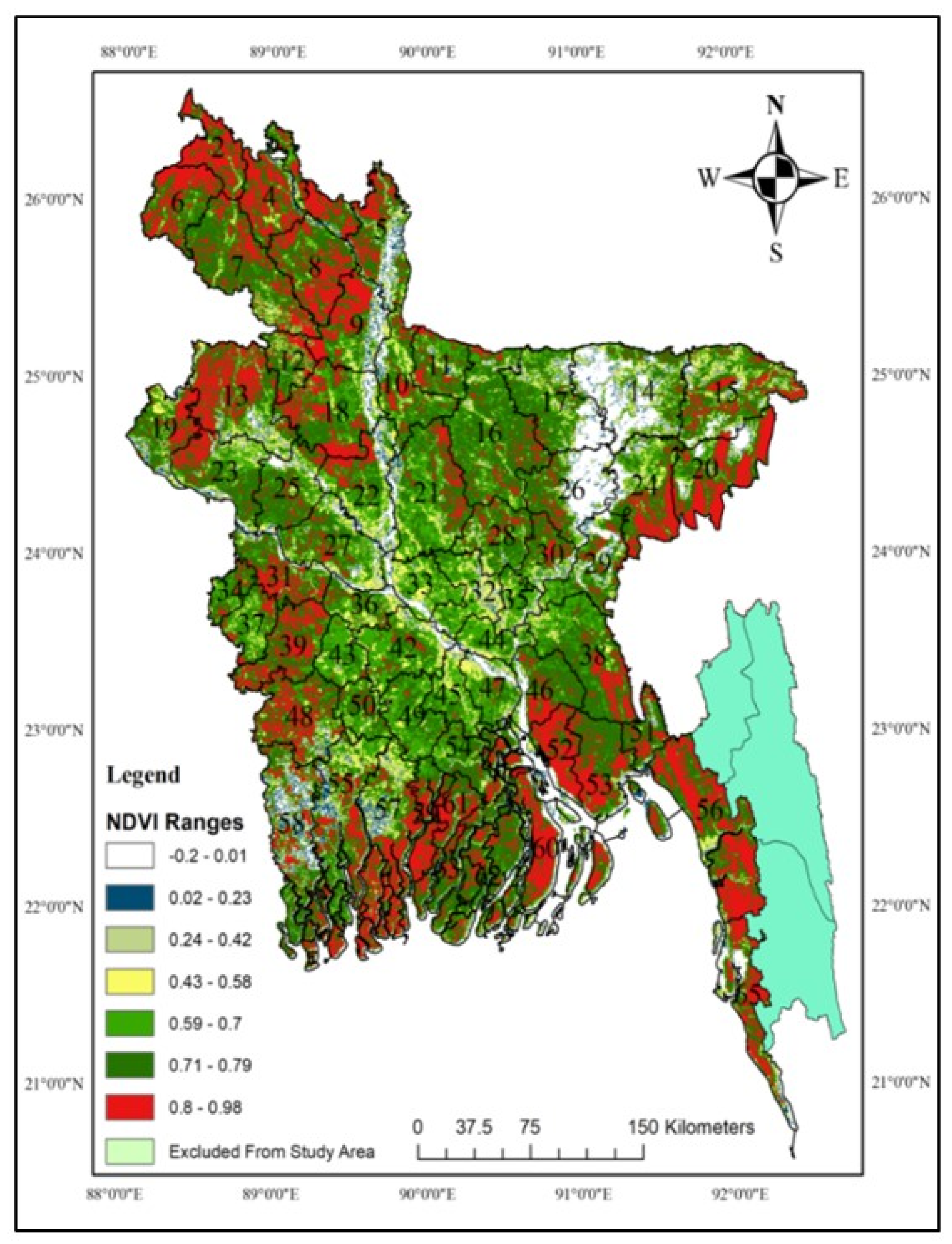
2.1. Study Area
2.2. Phenology of Aman Crop in Bangladesh
2.3. Geospatial Data Used
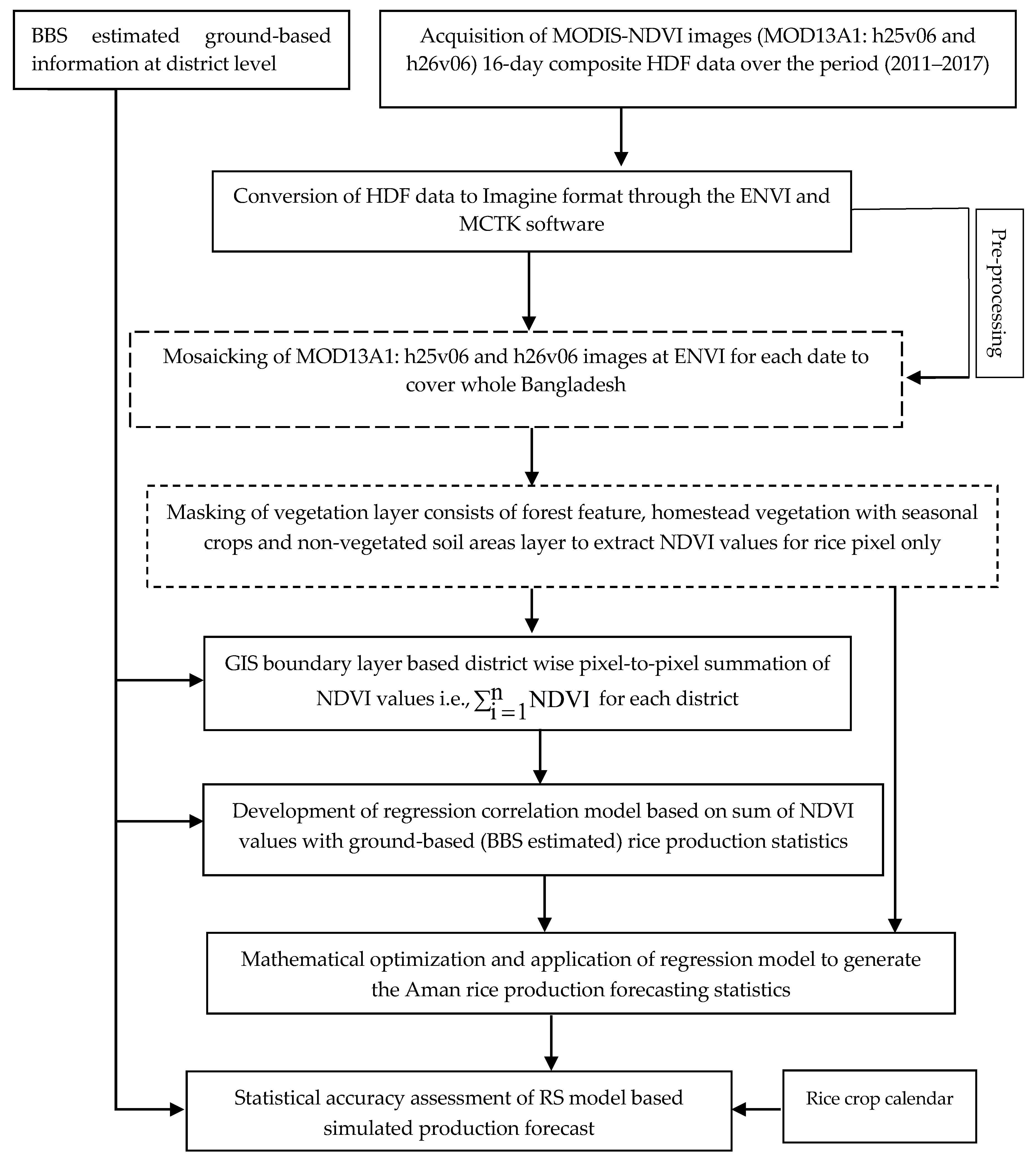
2.4. Methodological Framework
3. Results
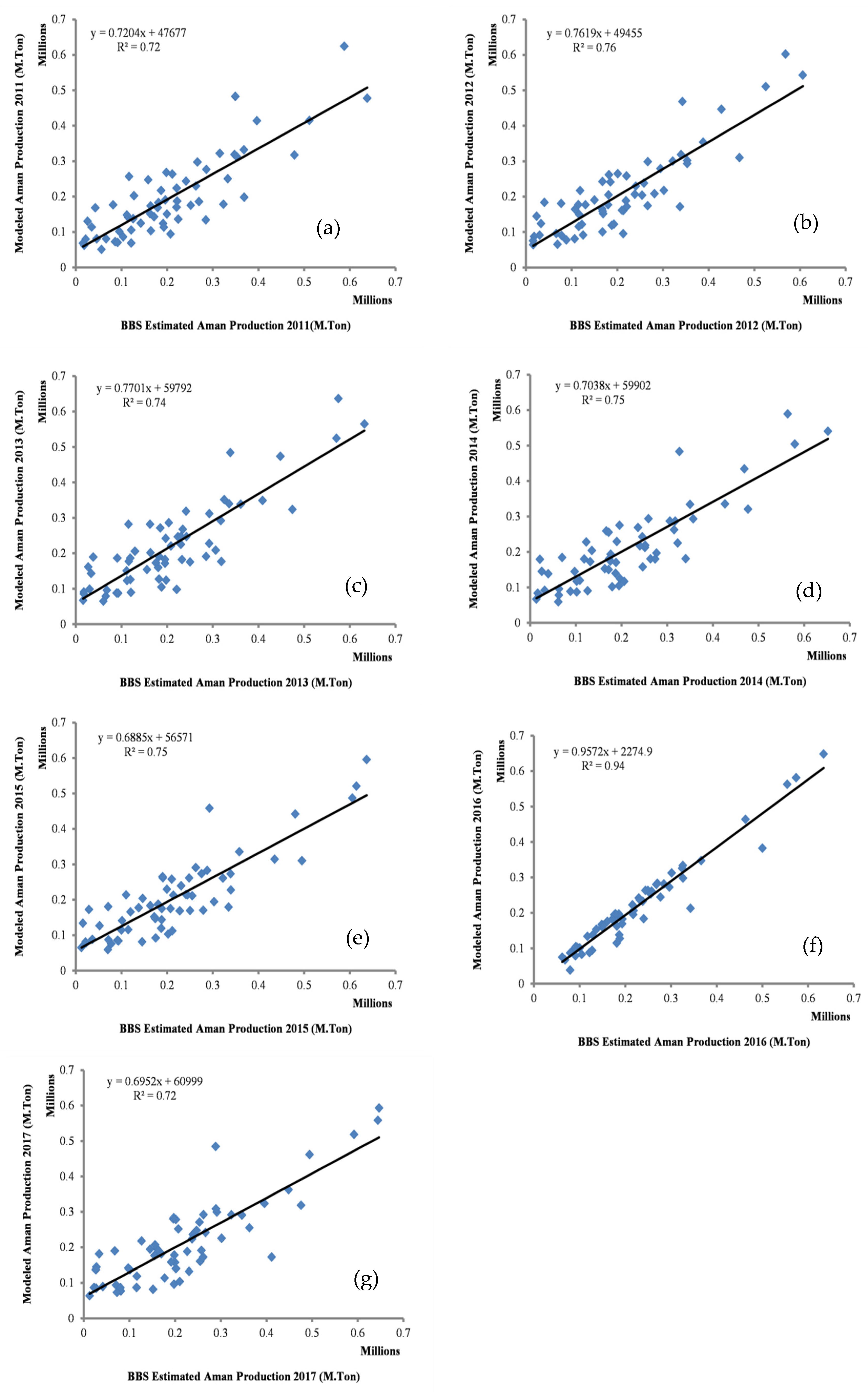
3.1. Remotely-Sensed Aman Rice Production Model
3.2. Simulation of Remotely Sensed Rice Production Model
3.3. Suitability Assessment of Developed ACP Model
4. Conclusions
Author Contributions
Funding
Acknowledgments
Conflicts of Interest
Appendix A

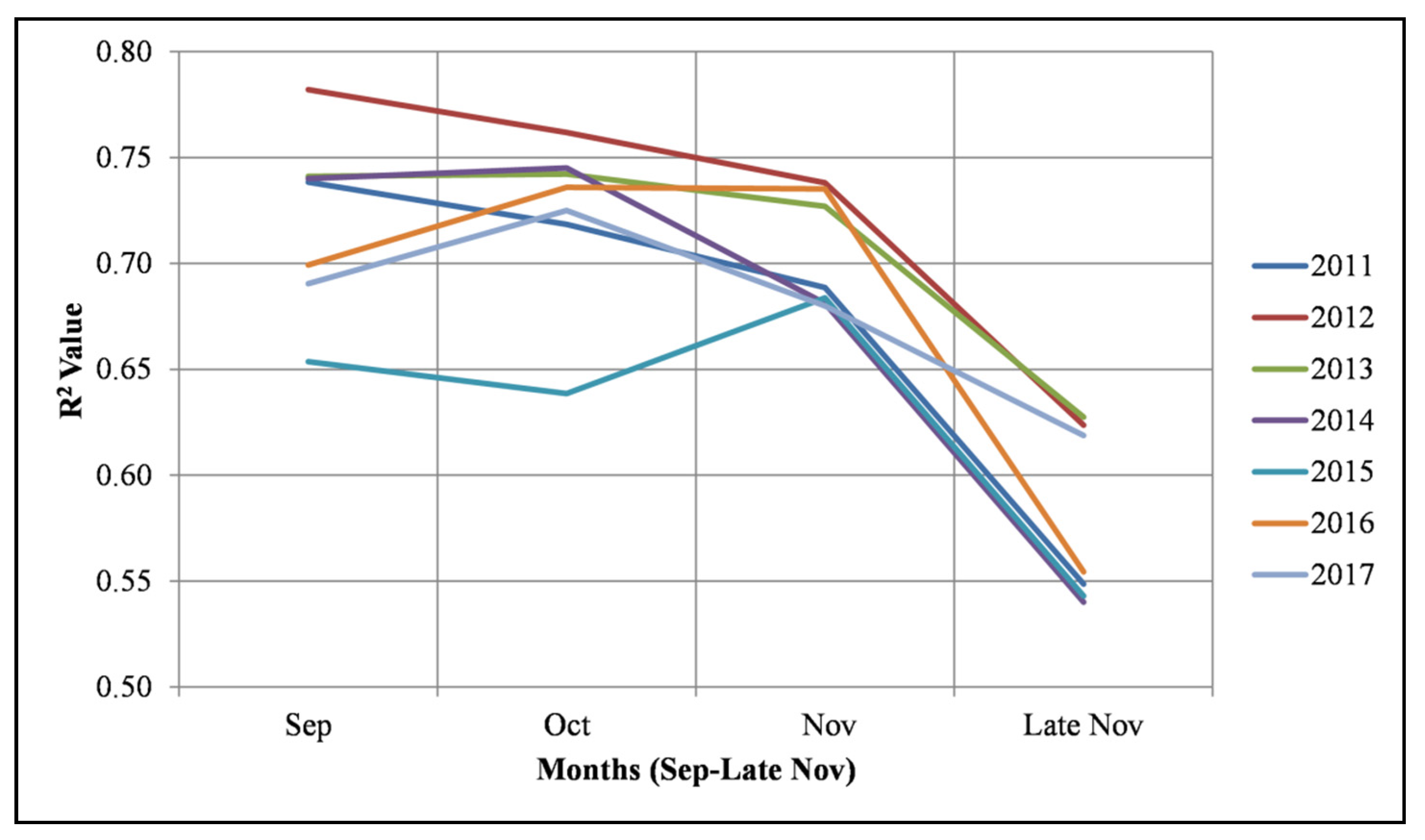
| Input Variables | Month | Day | Year | Satellite-Based Aman Crop Production Model | R2: Determination Coefficient | |
|---|---|---|---|---|---|---|
| MODIS NDVI (MOD13Q1) Versus Ground-based Estimated Production of 2011 | Sep | 30 | 2011 | y = 0.2517 | x = (−23,193) | 0.74 |
| Oct | 16 | 2011 | y = 0.2598 | x = (−18,833) | 0.72 | |
| Nov | 1 | 2011 | y = 0.2911 | x = (−24,592) | 0.69 | |
| Nov | 17 | 2011 | y = 0.3142 | x = (−10,619) | 0.55 | |
| MODIS NDVI (MOD13Q1) Versus Ground-based Estimated Production of 2012 | Sep | 29 | 2012 | y = 0.2596 | x = (−21,026) | 0.78 |
| Oct | 15 | 2012 | y = 0.2605 | x = (−29,779) | 0.76 | |
| Oct | 31 | 2012 | y = 0.2776 | x = (−24,748) | 0.74 | |
| Nov | 16 | 2012 | y = 0.3118 | x = (−19,556) | 0.62 | |
| MODIS NDVI (MOD13Q1) Versus Ground-based Estimated Production of 2013 | Sep | 30 | 2013 | y = 0.2431 | x = (−28,042) | 0.74 |
| Oct | 16 | 2013 | y = 0.2511 | x = (−32,388) | 0.74 | |
| Nov | 1 | 2013 | y = 0.3003 | x = (−31,778) | 0.73 | |
| Nov | 17 | 2013 | y = 0.3318 | x = (−23,808) | 0.63 | |
| MODIS NDVI (MOD13Q1) Versus Ground-based Estimated Production of 2014 | Sep | 30 | 2014 | y = 0.2657 | x = (−38,250) | 0.74 |
| Oct | 16 | 2014 | y = 0.2757 | x = (−41,011) | 0.75 | |
| Oct | 31 | 2014 | y = 0.298 | x = (−35,704) | 0.68 | |
| Nov | 17 | 2014 | y = 0.3439 | x = (−14,072) | 0.54 | |
| MODIS NDVI (MOD13Q1) Versus Ground-based Estimated Production 2015 | Sep | 30 | 2015 | y = 0.2622 | x = (−34,210) | 0.65 |
| Oct | 16 | 2015 | y = 0.1754 | x = (−26,854) | 0.64 | |
| Nov | 1 | 2015 | y = 0.3107 | x = (−35,090) | 0.68 | |
| Nov | 17 | 2015 | y = 0.3157 | x = (−16,129) | 0.54 | |
| MODIS NDVI (MOD13Q1) Versus Ground-based Estimated Production of 2016 | Sep | 29 | 2016 | y = 0.2562 | x = (−11,222) | 0.70 |
| Oct | 16 | 2016 | y = 0.2602 | x = (−29,813) | 0.74 | |
| Oct | 31 | 2016 | y = 0.2601 | x = (−29,783) | 0.74 | |
| Nov | 17 | 2016 | y = 0.3352 | x = (−20,508) | 0.55 | |
| MODIS NDVI (MOD13Q1) Versus Ground-based Estimated Production of 2017 | Sep | 30 | 2017 | y = 0.2558 | x = (−8147.3) | 0.69 |
| Oct | 16 | 2017 | y = 0.2716 | x = (−33,632) | 0.72 | |
| Nov | 1 | 2017 | y = 0.2878 | x = (−31,295) | 0.68 | |
| Nov | 17 | 2017 | y = 0.3209 | x = (−20,336) | 0.62 | |
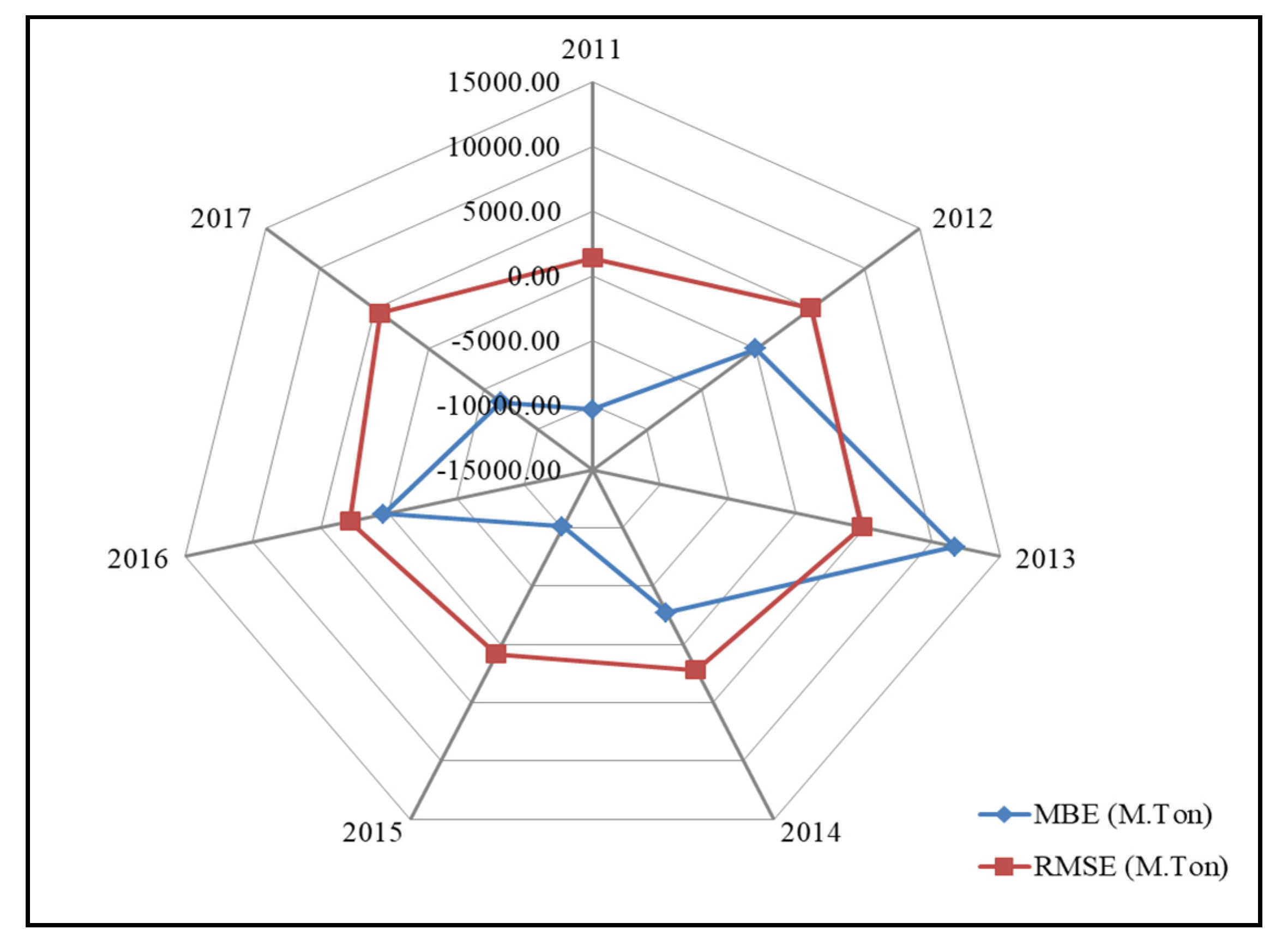
| Year | Aman Rice Production (M.Ton) | R2 | MBE (M.Ton) | RMSE (M.Ton) | ME | |
|---|---|---|---|---|---|---|
| RS Model Estimated | BBS Estimated | |||||
| 2011 | 12,029,108 | 12,660,663 | 0.72 | −10,353 | 1374 | 0.90 |
| 2012 | 12,663,105 | 12,661,584 | 0.76 | 24 | 5067 | 0.92 |
| 2013 | 13,473,504 | 12,760,304 | 0.74 | 11,691 | 4831 | 0.92 |
| 2014 | 12,729,610 | 12,895,079 | 0.75 | −2712 | 2191 | 0.91 |
| 2015 | 12,442,664 | 13,060,239 | 0.75 | −10,124 | 842 | 0.90 |
| 2016 | 13,372,820 | 13,352,668 | 0.94 | 330 | 2818 | 0.91 |
| 2017 | 13,125,570 | 13,528,734 | 0.72 | −6609 | 4449 | 0.90 |
References
- Bangladesh Bureau of Statistics (BBS). Yearbook of Agricultural Statistics (2010–2012); Statistics and Informatics Division (SID), Ministry of Planning, Government of the People’s Republic of Bangladesh: Dhaka, Bangladesh. Available online: http://www.bbs.gov.bd (accessed on 21 January 2019).
- Sattar, S.A. Bridging the Rice Yield Gap in Bangladesh. In Bridging the Rice Yield Gap in the Asia-Pacific Region; Papademetriou, M.K., Dent, F.J., Herath, E.M., Eds.; FAO Regional Office of the UN for Asia and the Pacific: Bangkok, Thailand, 2000. [Google Scholar]
- Wang, L.-F.; Kong, J.A.; Ding, K.H.; Le Toan, T.; Ribbes, F.; Floury, N. Electromagetic Scattering Model for Rice Canopy B+ased on Monte Carlo Simulation. Progress Electromagn. Res. 2005, 52, 153–171. [Google Scholar] [CrossRef] [Green Version]
- Rashid, M.M. Rice Production in Bangladesh: Programmes, Achievements, Potentials and Challenges; International Rice Commission Newsletter, FAO: Rome, Italy, 1994; Volume 43, pp. 9–18. [Google Scholar]
- FAO. Rice: Post-harvest Operations; Food and Agriculture Organization (FAO) of United Nations, International Rice Research Institute: Los Baños, Philippines, 1999; Available online: http://www.fao.org/fileadmin/user_upload/inpho/docs/Post_Harvest_Compendium_-_RICE.pdf (accessed on 21 January 2019).
- Reynolds, C.A.; Yitayew, M.; Slack, D.C.; Hutchinson, C.F.; Huete, A.; Petersen, M.S. Estimating crop yields and production by integrating the FAO crop specific water balance model with real- time satellite data and ground-based ancillary data. Int. J. Remote Sens. 2000, 21, 3487–3508. [Google Scholar] [CrossRef]
- Narasimhan, R.L.; Chandra, H. Application of remote sensing in agricultural statistics. Indian J. Agric. Econ. 2000, 55, 120–124. [Google Scholar]
- Dadhwal, V.K.; Ray, S.S. Crop assessment using remote sensing—Part II: Crop condition and yield assessment. Indian J. Agric. Econ. 2000, 55, 54–67. [Google Scholar]
- Bastiaanssen, W.G.M.; Ali, S. A new crop yield forecasting model based on satellite measurements applied across the Indus Basin Pakistan. Agric. Ecosyst. Environ. 2003, 94, 321–340. [Google Scholar] [CrossRef]
- Prasad, A.K.; Chai, L.; Singh, R.P. Crop yield estimation model for Iowa using remote sensing and surface parameters. Int. J. Appl. Earth Obs. Geoinf. 2006, 8, 26–33. [Google Scholar] [CrossRef]
- Banair, A. A review of vegetation indices. Remote Sens. 1995, 13, 95–120. [Google Scholar] [CrossRef]
- Zhao, L.; Duan, L. The analysis of main factors affecting grain yield in Inner Mongolia Autonomous Region. J. Northwest Sci.-Tec. Univ. Agric. Forest. 2001, 29, 77–80. [Google Scholar]
- Nuarsa, I.W.; Nishio, F.; Hongo, C. Rice yield estimation using Landsat ETM+ data and field observation. J. Agric. Sci. 2012, 4, 45–56. [Google Scholar] [CrossRef] [Green Version]
- Seifried, R. Archaeology in (Geo)Space, Stories from One GIS-Using-Archaeologist to Another. Available online: https://rmseifried.com/2014/09/19/satellite-imagery-types-resolution-and-pricing (accessed on 19 October 2017).
- Kohiyama, M.; Estrada, M.; Yamazaki, F. Damage Detection Method Using Middle-Resolution Resolution Optical Satellite Images Based on Normal Fluctuation of Digital Numbers in Multi-Temporal Images; Workshop on Application of Remote Sensing Technologies for Disaster Response: Tokyo, Japan, 12 September 2003. [Google Scholar]
- Whitcraft, A.K.; Becker-Reshef, I.; Justice, C.O. A framework for defining spatially explicit earth observation requirements for a global agricultural monitoring initiative (GEOGLAM). Remote Sens. 2015, 7, 1461–1481. [Google Scholar] [CrossRef] [Green Version]
- Okamoto, K. Estimation of rice-planted area in the tropical zone using a combination of optical and microwave satellite sensor data. Int. J. Remote Sens. 1999, 20, 1045–1048. [Google Scholar] [CrossRef]
- Wiegand, C.L.; Rechardson, A.J.; Escobar, D.E.; Gerbermann, A.H. Vegetation indices in crop assessment. Remote Sens. Environ. 1990, 35, 105–119. [Google Scholar] [CrossRef]
- Holben, B.N.; Tucker, C.J.; Fan, C.J. Spectral assessment of soybean leaf area and leaf biomass. Photogramm. Eng. Remote Sens. 1980, 46, 651–656. [Google Scholar]
- Nemani, R.R.; Running, S.W. Testing a theoretical climate-soil leaf area hydrological equilibrium of forests using satellite data and ecosystem simulation. Agric. For. Meteorol. 1989, 44, 245–260. [Google Scholar] [CrossRef]
- Mkhabela, M.S.; Bullock, P.; Raj, S.; Wang, S.; Yang, Y. Crop yield forecasting on the Canadian prairies using MODIS NDVI data. Agric. For. Meteol. 2011, 151, 385–393. [Google Scholar] [CrossRef]
- Kouadio, L.; Newlands, N.K.; Davidson, A.; Zhang, Y.; Chipanshi, A. Assessing the Performance of MODIS NDVI and EVI for seasonal crop yield forecasting at the eco district scale. Agric. For. Meteorol. 2014, 173, 74–84. [Google Scholar]
- Mahboob, M.G.; Islam, A.T.; Deshapriya, L. Rice mapping and monitoring in Sylhet region of Bangladesh using MODIS NDVI. In Proceedings of the Asia Flux Mini-Workshop on Remote sensing and ecological/environmental monitoring, National Taiwan University, Taipei, Taiwani, 2–4 March 2016; Available online: http://asiaflux.net/index.php?key=muhz8divr-26#_26 (accessed on 21 January 2019).
- Faisal, B.; Rahman, H.; Sharifee, N.; Sultana, N.; Islam, M.; Ahammad, T. Remotely Sensed Boro Rice Production Forecasting Using MODIS-NDVI: A Bangladesh Perspective. AgriEngineering 2019, 1, 356–375. [Google Scholar] [CrossRef] [Green Version]
- Boschetti, M.; Stroppiana, D.; Brivio, P.A.; Bocchi, S. Multi-year monitoring of rice crop phenology through time series analysis of MODIS images. Int. J. Remote Sens. 2009, 30, 4643–4662. [Google Scholar] [CrossRef]
- Colombo, R.; Busetto, L.; Fava, F.; Di Mauro, B.; Migliavacca, M.; Cremonese, E.; Galvagno, M.; Rossini, M.; Meroni, M.; Cogliati, S.; et al. Phenological monitoring of grassland and larch in the Alps from Terra and Aqua MODIS images. Ital. J. Remote Sens. 2011, 43, 83–96. [Google Scholar]
- Hmimina, G.; Dufrene, E.; Pontailler, J.Y.; Delpierre, N.; Aubinet, M.; Caquet, B.; de Grandcourt, A.; Burban, B.; Flechar, C.; Granier, A.; et al. Evaluation of the potential ofMODIS satellite data to predict vegetation phenology in different biomes: An investigation using ground-based NDVI measurements. Remote Sens. Environ. 2013, 132, 145–158. [Google Scholar] [CrossRef]
- Soudani, K.; Francois, C.; le Maire, G.; Le Dantec, V.; Dufrene, E. Comparative analysis of IKONOS, SPOT, and ETM+ data leaf area index estimation in temperature coniferous and deciduous forest stands. Remote Sens. Environ. 2006, 102, 161–175. [Google Scholar] [CrossRef] [Green Version]
- Sesnie, S.E.; Dickson, B.G.; Rosenstock, S.S.; Rundall, J.M. A comparison of Landsat TM and MODIS vegetation indices for estimating forage phenology in desert bighorn sheep (Oviscanadensisnelsoni) habitat in the Sonoran Desert, USA. Int. J. Remote Sens. 2012, 33, 276–286. [Google Scholar] [CrossRef]
- Xiao, X.; Boles, S.; Liu, J.; Zhuang, D.; Frolking, S.; Li, C.; Salas, W.; Moore, B., III. Mapping paddy rice agriculture in southern China using multi-temporal MODIS images. Remote Sens. Environ. 2005, 95, 480–492. [Google Scholar] [CrossRef]
- Xiao, X.; Boles, S.; Frolking, S.; Li, C.S.; Babu, J.Y.; Salas, W.; Moore, B., III. Mapping paddy rice agriculture in South and Southeast Asia using multi-temporal MODIS images. Remote Sens. Environ. 2006, 100, 95–113. [Google Scholar] [CrossRef]
- Shiu, Y.; Lin, M.; Huang, C.; Chu, T. Mapping paddy rice agriculture in a highly fragmented area using a geographic information system object-based post classification process. J. Appl. Remote Sens. 2012, 6, 063526. [Google Scholar]
- Master Planning Organization (MPO). National Water Management Plan: Phase II; Final Report-1991; Ministry of Irrigation, Water Development and Flood Control, Government of the People’s Republic of Bangladesh: Dhaka, Bangladesh, 1991.
- Gumma, M.K.; Thenkabail, P.S.; Maunahan, A.; Islam, S.; Nelson, A. Mapping seasonal rice cropland extent and area in the high cropping intensity environment of Bangladesh using MODIS 500m data for the year 2010. Isprs J. Photogramm. Remote Sens. 2014, 91, 98–113. [Google Scholar] [CrossRef]
- Nelson, A.; Setiyono, T.; Rala, A.; Quicho, E.; Raviz, J.; Abonete, P.; Maunahan, A.; Garcia, C.; Bhatti, H.; Villano, L.; et al. Towards an Operational SAR-Based Rice Monitoring System in Asia: Examples from 13 Demonstration Sites across Asia in the RIICE Project. Remote Sens. 2014, 6, 10773–10812. [Google Scholar] [CrossRef] [Green Version]
- Bangladesh Bureau of Statistics (BBS). Statistical Pocketbook of Bangladesh-2016; Government of the People’s Republic of Bangladesh: Dhaka, Bangladesh, 2017. Available online: http://www.bbs.gov.bd (accessed on 21 January 2019).
- Bangladesh Bureau of Statistics (BBS). Statistical Pocketbook of Bangladesh-2006; Government of the People’s Republic of Bangladesh: Dhaka, Bangladesh, 2007. Available online: http://www.bbs.gov.bd (accessed on 21 January 2019).
- Didan, K. MOD13A1: MODIS/Terra Vegetation Indices 16-Day L3 Global 500m SIN Grid V006; NASA EOSDIS LP DAAC: Sioux Falls, SD, USA, 2015.
- Bangladesh Bureau of Statistics (BBS). Yearbook of Agricultural Statistics-2016; Statistics and Informatics Division (SID), Ministry of Planning, Government of the People’s Republic of Bangladesh: Dhaka, Bangladesh, 2017. Available online: http://www.bbs.gov.bd (accessed on 21 January 2019).
- Bala, S.K.; Islam, A.S. Correlation between potato yield and MODIS-derived vegetation indices. Int. J. Remote Sens. 2009, 30, 2491–2507. [Google Scholar] [CrossRef]
- Gat, N.; Erives, H.; Fitzegerald, G.J.; Ka_ka, S.R.; Mass, S.J. Estimate Sugar Beet Yield Using AVIRIS-Derived Indices. 2000. Available online: http://makalu.jpl.nasa.gov/docs/workshops/00_docs/Gat_web.pdf (accessed on 18 September 2007).
- Liu, W.T.; Kogan, F. Monitoring Brazilian soybean production using NOAA/AVHRR based vegetation condition indices. Int. J. Remote Sens. 2002, 23, 1161–1179. [Google Scholar] [CrossRef]
- Nessa, M. Monitoring of Rice Growth and Production in Bangladesh Using NOAA Satellite Data; Bangladesh University of Engineering and Technology: Dhaka, Bangladesh, 2004. [Google Scholar]
- Becker-Reshef, I.; Justice, C.; Sullivan, M.; Vermote, E.; Tucker, C.; Anyamba, A.; Small, J.; Pak, E.; Masuoka, E.; Schmaltz, J.; et al. Monitoring global croplands with coarse resolution earth observations: The global agriculture monitoring (GLAM) project. Remote Sens. 2010, 2, 1589–1609. [Google Scholar] [CrossRef] [Green Version]
- Boken, V.K.; Shaykewich, C.F. Improving an operational wheat yield model using phenological phase-based Normalized Di_erence Vegetation Index. Int. J. Remote Sens. 2002, 23, 4155–4168. [Google Scholar] [CrossRef]
- Rojas, O. Operational maize yield model development and validation based on remote sensing and agro-meteorological data in Kenya. Int. J. Remote Sens. 2007, 28, 3775–3793. [Google Scholar] [CrossRef] [Green Version]
- Doraiswamy, P.C.; Cook, P.W. Spring wheat yield assessment using NOAA AVHRR data. Can. J. Remote Sens. 1995, 21, 43–51. [Google Scholar] [CrossRef]
- Benedetti, R.; Rossini, P. On the use of NDVI profiles as a tool for agricultural statistics: The case study of wheat yield estimate and forecast in Emilia Romagna. Remote Sens. Environ. 1993, 45, 311–326. [Google Scholar] [CrossRef]
- Tucker, C.J.; Holben, B.N.; Elgin, J.H.; McMurtrey, J.E. Relationship of spectral data to grain yield variation. Photogramm. Eng. Remote Sens. 1980, 46, 657–666. [Google Scholar]
- Nuarsa, I.W.; Nishio, F.; Hongo, C. Relationship between rice spectral and rice yield using MODIS data. J. Agric. Sci. 2011, 3, 80–88. [Google Scholar] [CrossRef] [Green Version]
- Siyal, A.A.; Dempewolf, J.; Becker-Reshef, I. Rice yield estimation using Landsat ETM_Data. J. Appl. Remote Sens. 2015, 9, 095986. [Google Scholar] [CrossRef]
- Huang, J.; Wang, X.; Li, X.; Tian, H.; Pan, Z. Remotely sensed rice yield prediction using multi-temporal NDVI data derived from NOAA’s-AVHRR. PLoS ONE 2013, 8, e70816. [Google Scholar] [CrossRef]
- Noureldin, N.A.; Aboelghar, M.A.; Saudy, H.S.; Ali, A.M. Rice yield forecasting models using satellite imagery in Egypt. Egypt. J. Remote Sens. Space Sci. 2013, 16, 125–131. [Google Scholar] [CrossRef] [Green Version]
- Willmott, C.J. Some comments on the evaluation of model performance. Bull. Am. Meteorol. Soc. 1982, 63, 1309–1313. [Google Scholar] [CrossRef] [Green Version]
- Chai, T.; Draxler, R.R. Root mean square error (RMSE) or mean absolute error (MAE)?—Arguments against avoiding RMSE in the literature. Geosci. Model Dev. 2014, 7, 1247–1250. [Google Scholar] [CrossRef] [Green Version]
- Fuller, D.O. Trends in NDVI time series and their relation to rangeland and crop production in Senegal, 1987–1993. Int. J. Remote Sens. 1998, 19, 2013–2018. [Google Scholar] [CrossRef]
- Shew, A.M.; Ghosh, A. Using multi-temporal remote sensing data to analyze the spatio-temporal patterns of dry season rice production in Bangladesh. In Proceedings of the 2nd International Symposium on Spatiotemporal Computing, ISPRS Annals of the Photogrammetry, Remote Sensing and Spatial Information Sciences, Cambridge, MA, USA, 7–9 August 2017; Volume IV-4/W2. [Google Scholar]
- Son, N.T.; Chen, C.F.; Chen, C.R.; Chang, L.Y.; Duc, H.N.; Nguyen, L.D. Prediction of rice crop yield using MODIS EVI-LAI -data in the Mekong Delta, Vietnam. Int. J. Remote Sens. 2013, 34, 7275–7292. [Google Scholar] [CrossRef]
- Wang, Y.P.; Chang, K.W.; Chen, R.K.; LO, J.C.; Shen, Y. Large-area rice yield forecasting using satellite imageries. Int. J. Appl. Earth Obs. Geoinf. 2010, 12, 27–35. [Google Scholar] [CrossRef]
- Mosleh, M.K.; Hassan, Q.K.; Chowdhury, E.H. Application of remote sensors in mapping rice area and forecasting its production: A review. Sensors 2015, 15, 769–791. [Google Scholar] [CrossRef] [Green Version]

| Phases (Days) | |||
|---|---|---|---|
| Vegetative Phase | Reproductive Phase | Ripening Phase | Total |
| 55–85 days | 30–35 days | 30–35 days | 115–155 days |
| Data Source | Data Description | Data Type | Pixel Size | Composite Technique | File Format |
|---|---|---|---|---|---|
| Terra MODIS | 500 m 16 days NDVI | 16-bit signed integer | 500 m | MVC (Maximum Value Composite) | HDF-EOS |
© 2020 by the authors. Licensee MDPI, Basel, Switzerland. This article is an open access article distributed under the terms and conditions of the Creative Commons Attribution (CC BY) license (http://creativecommons.org/licenses/by/4.0/).
Share and Cite
Faisal, B.M.R.; Rahman, H.; Sharifee, N.H.; Sultana, N.; Islam, M.I.; Habib, S.M.A.; Ahammad, T. Integrated Application of Remote Sensing and GIS in Crop Information System—A Case Study on Aman Rice Production Forecasting Using MODIS-NDVI in Bangladesh. AgriEngineering 2020, 2, 264-279. https://doi.org/10.3390/agriengineering2020017
Faisal BMR, Rahman H, Sharifee NH, Sultana N, Islam MI, Habib SMA, Ahammad T. Integrated Application of Remote Sensing and GIS in Crop Information System—A Case Study on Aman Rice Production Forecasting Using MODIS-NDVI in Bangladesh. AgriEngineering. 2020; 2(2):264-279. https://doi.org/10.3390/agriengineering2020017
Chicago/Turabian StyleFaisal, B. M. Refat, Hafizur Rahman, Nur Hossain Sharifee, Nasrin Sultana, Mohammad Imrul Islam, S. M. Ahsan Habib, and Tofayel Ahammad. 2020. "Integrated Application of Remote Sensing and GIS in Crop Information System—A Case Study on Aman Rice Production Forecasting Using MODIS-NDVI in Bangladesh" AgriEngineering 2, no. 2: 264-279. https://doi.org/10.3390/agriengineering2020017