Article

Integration of SETS (Social–Ecological–Technological Systems) Framework and Flood Resilience Cycle for Smart Flood Risk Management

Graduate School of Media and Governance, Keio University, 5322 Endo, Fujisawa-shi 252-0882, Japan
*
Author to whom correspondence should be addressed.
Smart Cities 2022, 5(4), 1312-1335; https://doi.org/10.3390/smartcities5040067
Submission received: 25 July 2022 / Revised: 26 September 2022 / Accepted: 27 September 2022 / Published: 30 September 2022
(This article belongs to the Special Issue Smart City Related Policies and Implementation)

Abstract

:
The concept of “water smart city” is increasingly being recognized as a new approach to managing urban environments (including urban floods), especially in the context of developing countries, such as Indonesia. While Indonesia’s national capital relocation plan is expected to attract significant human migration to two nearby cities, Samarinda City and the port city of Balikpapan, these cities have continuously faced with severe risk of flooding. Therefore, this research proposes a flood management approach by reviewing the local city government’s flood risk management strategies and the smart city plan to enhance flood resilience. The integration of the SETS (Social–Ecological–Technological systems) framework and the Flood Resilience Cycle is undertaken to determine the state of flood management, which is followed by a review of smart city plans and programs in two selected cities (Samarinda and Balikpapan). The research mainly identifies how it can be implemented in the two selected cities based on SETS–FRC distribution. In accordance with the SETS–FRC (Flood Resilience Cycle) framework, it is revealed that both these cities have a higher emphasis on the flood prevention phase, as compared to other resilience phases. Based on the overall results, this study emphasizes the implementation of a water smart city concept for effective and smart flood risk management.

1. Introduction

Flooding, in general, refers to the temporary inundation of any land surface that becomes uninhabitable due to the presence of water [1]. The increase in volume and the distribution of precipitation in a drainage basin is the most common cause of river flooding; however, events such as dam failure can also induce flooding [2,3]. Against the backdrop of an increasing urban population, the risk of flooding has particularly increased in many urban areas worldwide [4], affecting more than 2.3 billion people [5,6]. While floods are becoming increasingly more common, the changing nature of floods is also becoming a serious concern [7]. For instance, rapid urban development trends are leading to increased volumes of flood runoff, pressing the threshold capacity of river basins.
Indonesia, as a developing country, faces, at present, severe flood problems in most of urban areas [8,9]. To effectively address this challenge, the Government of Indonesia is currently planning to relocate the nation’s capital, with the objective of creating an ideal national government center that embodies the country’s identity while enabling long-term visionary development [10]. According to Indonesia’s Ministry of National Development Planning (BAPPENAS), issued in 2020, more than 50,000 civil servants and their dependents are likely to be relocated because of the capital movement. As a result, the newly appointed capital and its surrounding cities, including Balikpapan and Samarinda, are required to accommodate around 1.5 million people [11]. Correspondingly, the swift development of Indonesia’s new capital city may have drastic implications for the surrounding areas, especially from the perspective of disaster vulnerability.
In case of Balikpapan and Samarinda, flooding is a significant problem. There, the local governments are already undertaking many efforts to protect the people and the cities from flooding [12]. Recently, the local government agencies have also attempted to develop a resilience concept considering the recurring flood disasters. Despite that, a genuine need has been recognized to improve the system resilience at the municipal, provincial, and national levels [13]. Recent studies suggest that disaster resilience is a challenging issue to address in development plans. Conducting research in Melbourne, Australia, on adaptive capacity building, Moloney and Fünfgeld (in 2015) emphasized the need for local government participation in reducing floods [14]. Further, Chmutina [15] also reviewed thirty government papers in the United Kingdom (UK) to understand how resilience is perceived and which measures are applied to improve community resilience. It has been acknowldged that a flood protection program must essentially overcome barriers to information sharing and dissemination within the community. Flood working groups for priority catchments strive to reach as many individuals as possible, but in the future, innovative methods are required to reach all vulnerable community members [16], as successful disaster risk management depends on the local community. Markedly, the focus of flood risk reduction in Indonesia remains to be on structural measures [8] and little attention is being paid on community contribution [17].
Urban environments are at present being perceived as dynamic social–ecological–technological (SETS) systems that are vulnerable to flooding from both within and outside of SETS domains and catch connections among their various components (Social–Ecological–Technological components) [18,19]. A few of the issues associated with urban environments (for example, floods) can be addressed by shifting from traditional flood and water management approaches to a “smart systems” approach that are more resilient to natural disasters [20]. This highlights the importance of identifying SETS as part of smart city planning and a prospective way of looking at urban risk in broader terms. Subsequently, a more comprehensive strategy for analyzing flood risk management in complex urban SETS is required, as well as for improving the resilience of SETS domains [21,22]. SETS provides an alternative approach for analyzing complex interactions between infrastructure, environment, and equality in society to better understand the social distribution of hazards. The SETS framework has, therefore, been lately utilized in cross-comparison of flood risk management [23]. For example, there is a flood study using SETS in US cities [23,24] and also the integration of FRM (Flood Risk Management) and SETS Framework has been used in Portland, Seoul, and Tokyo [23]. In due consideration of the effectiveness of SETS in recent studies, this study attempts to implement SETS in the context of Indonesia, as it is also faced with similar flood problems considering smart city planning.
The recent advancements of ICT, particularly in wireless communication, mobile communication devices, cloud technologies, and cloud computing, has encouraged the adoption of smart water management technologies [24]. These advances enable the continuous monitoring of water systems and their surroundings, real-time analysis and forecasting for early warning and decision-support systems, and quick responses to water-related emergencies. In addition, Smart Water Management has become an enabler for implementing Flood Resilience solutions and has a great synergy with Flood Resilience concepts. The Water Smart City strategy is also a forward-thinking method of integrating sustainable urban design and water management, mainly for lessening the negative effects of urbanization on the hydrological cycle [20]. In parallel, the concept of “smart cities” is also growing worldwide as a new approach to managing urban environments [25]. Smart cities have particularly received much attention in the last decade, as information and communications technology (ICT) has been adopted as a development strategy. Smart cities are areas that integrate digital infrastructure into their urban structure to serve their community better, while better managing the infrastructure and fostering livelihood for their communities [26].
Nowadays, water infrastructure and their surroundings can accordingly be monitored in real time, and real-time forecasts for the early warning and decision–support systems have become possible with the smart city concept. ICT is used in both Flood Resilience and Smart City to support the sustainable, well-coordinated development, and management of water resources, laying the groundwork for a long-term approach to water management [27]. In a Water Smart City, water needs to be seen as an asset rather than a problem [28,29]. Prompt change is made possible through the combined efforts of companies, government agencies, academic institutions, and citizens [30]. Recently, the Minister of Public Works in Indonesia, Mr. Basuki, has also corroborated that a water smart city is an effective concept to reduce flood risk and it will be implemented in Indonesia as well [31].
Against this background, this paper particularly examines the contribution of smart cities plan (especially water smart city) to flood risk management based on the integration of SETS and the FRC (Flood Resilience Cycle) Framework, while addressing three key research questions: (i) What is the level of flood resilience based on SETS Framework? (ii) In what ways does the water smart city concept contribute towards enhancing flood resilience? (iii) What are the challenges of the current institutional arrangements for flood risk management? In recognition of the fact that the current strategies for facing floods mostly focus on structural methods and are less comprehensive [28,32], this research hopes to uncover new insights for enhancing flood risk reduction.

2. Material and Methods

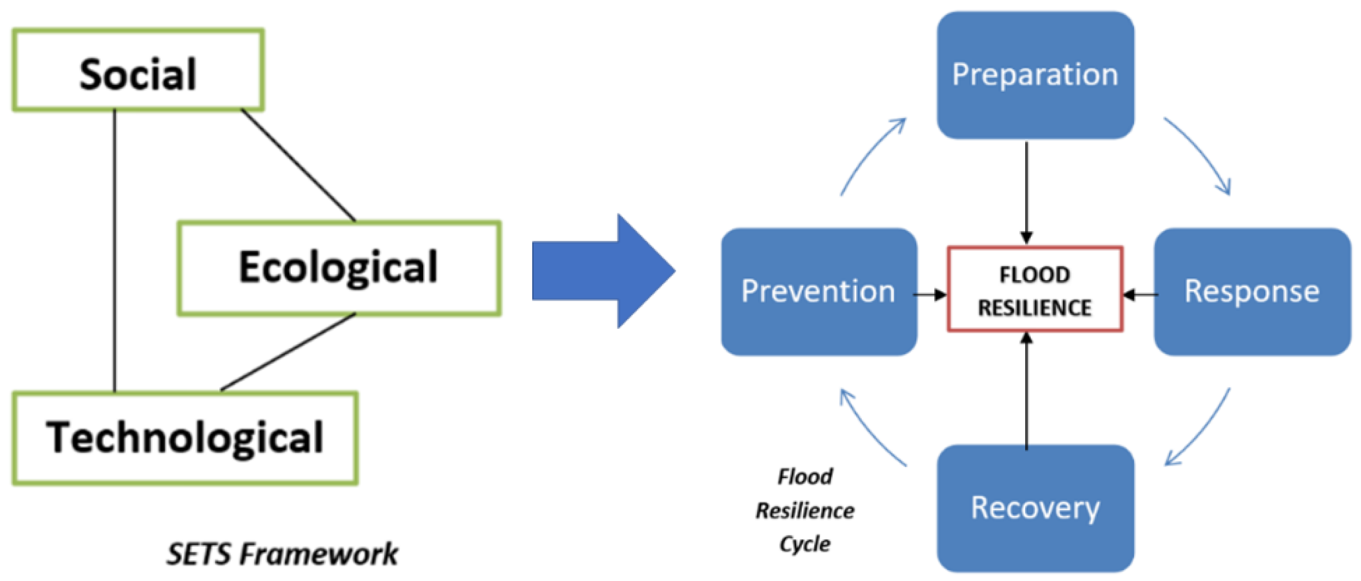
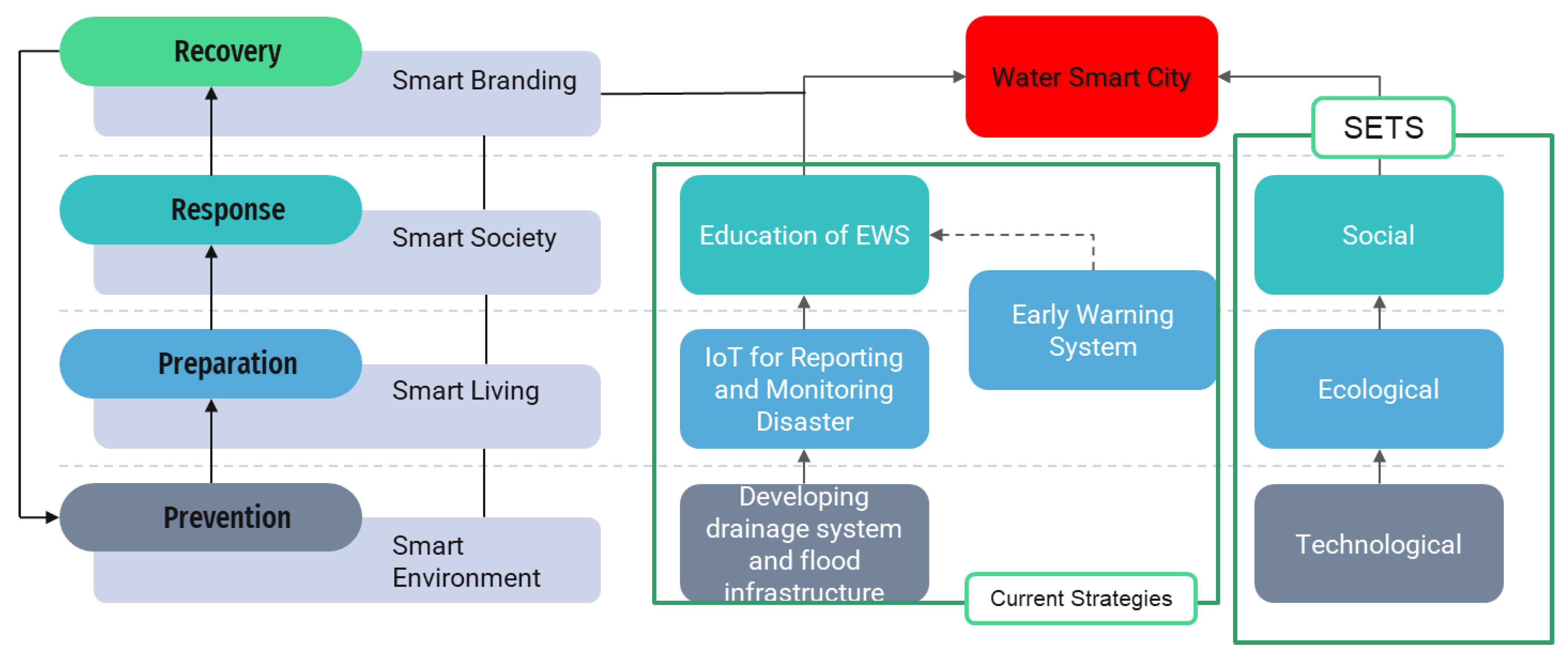
2.1. SETS Framework towards Flood Management and Resilience

Municipal governance is often influenced by a variety of factors, including but not limited to governing structures, policies, formal and informal codes, local knowledge systems, practitioners, public officials, and communities [33,34]. Accordingly, the local flood management plans and programs need to be designed as per each municipality’s specific government systems and regional characteristics [21]. The city plan reflects on the goals created by various institutions. It embodies direct relations among them to accomplish goals, illustrates appropriate governance policies, and envisages feasible expectations and consequences of these efforts [33].
For defining the concept of resilience, there are more than 70 recognized ways. It is commonly referred to as the ability to anticipate, plan for, absorb, recover from, or adapt more successfully to existing or projected unfavorable events [34]. Adaptation, in particular, refers to the capacity to adapt to new situations successfully [23]. Furthermore, the concept of resilience acknowledges “the existence of interconnected and interdependent sets of social, economic, natural, and manmade systems that support communities” [35]. As per the global disaster resilience framework, resilience is defined as a system’s, community’s, or society’s ability to adapt and recover from disasters in the shortest time possible [36]. A few researchers have also developed a conceptual framework that demonstrates the essence of urban governance, although additional research is necessary to strengthen the implementation of resilience initiatives and plans [37]. The use of urban governance to improve the quality of life, spatial organization, environmental management [38], and economic activity is also highly recommended in urban resilience management [31,39]. Urban governance as a concept includes decision-making processes, inclusiveness, and collaboration. Correspondingly, a city’s policies can impact how it builds a resilient city by guiding how to adapt resilience governance principles [40].
Moreover, there is no standardized framework in place to evaluate the value-sensitive resilience of decisions on disaster preparedness [23,41,42]. As different urban crises continue to emerge, determining how to make cities more resilient necessitates a strategy that incorporates a diverse set of expertise, data, and perspectives [31]. Cities and their components, such as neighborhoods, parks, and other infrastructure, are all part of a larger system. Since all the city’s components are interconnected, considering it as a distinct system is impractical (ecosystems, built environment, and communities).
The SETS framework incorporates all the city’s socio-political, political, cultural, and economic dynamics, as well as those of its decision makers. The ecological features of cities include nature’s biophysical aspects and processes, such as tree growth and soil development. The constructed components and associated activities of urban systems, such as roads or public transit networks, buildings, and the knowledge encoded in technologies, are the key examples of what is included in the technological dimensions of an urban environment [19]. When looking at cities through the lens of SETS, a few other fundamental questions regarding governance also arise. These questions include which institutions and areas of expertise are necessary, as well as who is impacted by changes in infrastructure [39]. How can the built environment reap the benefits of natural ecosystem services? How might technological advances be applied to infrastructure to make it more flexible or redundant? These issues need to be addressed for the SETS strategy to develop resilience and encourage sustainable paths [21].
Overall, there are four phases of intervention to achieve resilience, in this case, in Flood Resilience Cycle: prevention, preparation, response, and recovery phases. Prevention basically refers to flood avoidance, which involves activities that are required prior to a flood [41]. Accurate flood risk assessment requires identifying potential hazards and collaborating with those at risk to develop strategies for minimizing individual and communal vulnerability. Both structural and non-structural measures have been taken to prevent the expansion of the flood-prone area. The structural measures include building dams, levees, dikes, and diverging channels. Meanwhile, the non-structural measures relate to the campaigns of awareness and educating the people about flooding. In addition, since it is difficult to eliminate the risk of flooding, preparedness also focuses on mitigating the effects of flooding. If a greater effort is put into planning, cities will be better equipped to deal with severe and unexpected events.
The flood emergency plan calls for several actions to be taken in “response.” Emergency response can be made more efficient by adequately assigning rescue resources and developing evacuation strategies that minimize the effects of flooding [41]. A study in the Hawkesbury-Nepean River, NSW, Australia has created a new model to improve the preparedness of floods [42]. Floods not only cause problems on settlements, but also on critical public facilities, such as hospitals. As response tools, mathematical methods were used in that study so that if a flood occurs, the government and hospital residents can survive.
Furthermore, the Local Resilience Forum plans need to be nested within the community plans to allow smooth collaboration from the top-down and bottom-up. It is a standard error to impose top-down strategies on community-level plans [43]. Recovery will enable cities to recover promptly and perhaps even better than before a flood. Among the initiatives are plans for rebuilding or reconstruction, which may provide an opportunity to improve the city’s resilience to future disasters. Reconstruction is a two-pronged procedure that ensures that a city can be restored to its pre-disaster state while reducing the project’s completion time [41]. Additionally, the processes for reducing flood risk can affect a city’s components comprehensively. Integrating a Flood Risk Management System into social–ecological– technological systems are therefore very useful [19,23,24].

2.2. Significance of Water Smart Cities

Water smart cities are intended to make cities more sustainable, efficient, and livable. It serves as a holistic approach of water infrastructure management that includes sourcing, treatment, and distribution—the integration of stormwater and groundwater with wastewater management [44]. To accomplish water smart cities, there is a need for investing in Internet of Things (IoT) water infrastructure [45]. Previously, ICT was commonly utilized in centralized facilities within urban water infrastructures [46,47], such as drinking water and wastewater treatment plants [48,49], while control options for system components are now concentrated on a few key points. In urban drainage systems, for example, ICT is used to monitor combined sewer overflows (CSOs) [50,51] or distribution network inlet points for district meters [49]. These data are collected and analyzed by a supervisory control and data acquisition (SCADA) system, which UWI (Urban Water Infrastructure) is also used to control and regulate various pieces of control equipment [48]. New approaches of monitoring and management of network-based UWI can be developed with the help of the IoTs [49,52]. UWI’s integrated control and system-wide management are applied only occasionally, as described by Yuan et al. (2019) [48]. It is highly recommended that advanced technologies be used in conjunction with UWIs.
Water management issues in smart cities have lately been discussed in terms of technological breakthroughs in water and energy use [53,54]. Furthermore, the water management technology [52] has been introduced to support smart cities. For smart cities, the water resource cycle can be provided by leveraging the existing IT infrastructure and high-quality recycled water technology that is already in use in many cities [27]. In recent years, researchers have successfully integrated the water smart city system using an information and control system. This water system focuses more on reusing water for industrial and residential purposes [55]. Water plays an important role in smart city resilience [28]. Hence, there must be the integration of multiple infrastructure areas, such as water and energy, for a smart city to function optimally [56,57]. According to Babel et al. (2020), when water and energy networks are managed together, both water and energy savings can be achieved [58]. Sewage and river water quality monitoring is becoming more widespread, such as sensor networks, which are built on top of the most recent digital communication technologies [27,59,60,61,62].

2.3. Research Methods and Framework

This study intends to develop a method for evaluating and comparing the composition of two different framework (SETS and Flood Resilience) and an approach to linking the resilience phase into the smart city concept. Accordingly, this study applied the proposed strategy in two selected cities with the purpose of seeing how effective it can be and of gaining comparative insights. To achieve this, relevant policy documents were chosen for analysis (Appendix A. Since this paper focuses on municipal governance strategies for flood management, only those plans that were created and published by the government agencies, such as national, provincial, and municipal levels, were adopted. The following three criteria were followed for document analysis: (i) The document must be relevant to flood disaster; (ii) The document must be categorized in PPP document (Policy–Plan–Program); and (iii) Match the plans to the spatial scale under consideration (e.g., neighborhood, city-wide, regional, and national). Overall, nine documents were selected for Balikpapan City and six documents for Samarinda City.
The authors retrieved the materials from a database on the government’s website and also analyzed the PPP (Policy–Plan–Program) that explains flood risk. A detailed analysis of the selected documents was conducted to study the flood management strategies. The relevant documents were collected from government online databases, such as https://jdih.samarindakota.go.id/ (accessed on 20 December 2021) and https://jdih2.balikpapan.go.id/ (accessed on 20 December 2021) After gathering secondary data, purposive sampling was utilized to conduct in-depth interviews for exploring deeper into the subject of flood risk management in the study area. In the subsequent phase of research, key stakeholders from Balikpapan City and Samarinda City were interviewed. Additionally, the stakeholder input was used to confirm the current situation on the field.
Officials from three government agencies were interviewed, including the Disaster Management Agency, Environmental Agency, and Public Works Agency. Furthermore, the authors incorporated the models from SETS and Flood Resilience. The SETS components were initially coded and then mapped in the Flood Resilience as shown in Table 1. As discussed earlier, there are four phases of intervention to flood resilience in the Flood Resilience Cycle, which are prevention, preparation, response, and recovery. Mapping the SET domains and Flood Resilience Cycle helps to understand the current position of flood management in each city, while at the same time serves as an input for proposing the water smart city.
The framework presented in Figure 1 was used to evaluate flood risk management in the local government documents and for classifying the Flood Resilience Cycle, in line with the SETS domains into four phases: prevention, preparation, response, and recovery. To examine its distribution, specific flood management strategies were described in coded documents, which were categorized by S, E, and T elements. The current flood resilience phase was the input for proposing the smart flood risk management integrated with the master plan of the smart city in the selected cities.

3. Results

3.1. SETS in Local Government Documents

As buffer areas of mode’s new capital city, Balikpapan and Samarinda need to essentially strengthen their resilience in order to accommodate the projected massive growth in population and urbanization. From the perspective of disaster vulnerability, flooding is the most serious disaster in Balikpapan, followed by landslides [60], but for the past quarter-century, flooding has also been a concern in Samarinda [61]. It is also clear that the local governments in the both the cities consider flooding as a critical disaster that must be prevented. The characteristics of two selected cities can be seen on Table 2 below.
Based on the analysis of the municipal planning documents, the emphasis was laid on comprehending how flood management is planned by urban governance systems (with various socio-political, cultural, and biophysical contexts). This allowed us to assess whether the proposed solutions are successful and feasible, and how well they are integrated into local governance. By acquiring specific quotations from the papers, governance strategies were identified from a selection of municipal plans in each city. The extraction focused on quotations describing implementation strategies for flooding, actions, approaches to flood adaptation in general, and governance mechanisms to mitigate, adapt, and respond to flood disasters.
Appendix A shows the documents that meet the research criteria. In this paper, the authors present the key strategies for flooding, based on the government documents that were obtained from online government databases (https://jdih2.samarinda.go.Id (accessed on 20 December 2021). and https://jdih2.balikpapan.go.Id (accessed on 20 December 2021). There were nine documents for Balikpapan City and six documents for Samarinda City regarding flood management strategies. In addition, the authors developed the SETS codebook based on Berbés-Blázquez et al. (2017) and Hamstead et al. (2021) to better comprehend the SETS components of governance strategies [21,63]. Then, the strategies were organized according to the SETS domain, and a SETS code was assigned to each of them. Each strategy was identified in the two cities according to the SETS domain.
Based on the results derived through the coding, it is inferred that in Balikpapan there are six social domain strategies, eight ecological domain strategies, and nine technological domain strategies. Meanwhile, in Samarinda City, the social domain contains seven strategies, the ecological domain has only two, and the technological domain has nine. The distribution of the SETS domains for each city is presented in Figure 2 Even though both Balikpapan and Samarinda deal with the same problem (floods), their strategic approaches differ. According to Figure 3, Balikpapan follows a rather balanced strategy in the technological and ecological domains. Meanwhile, in Samarinda, the technological domain is more dominant than the social and ecological ones.
Balikpapan is dominated by flood strategies, which leads to the ecological code-1 (E-1) of conservation, preservation, and restoration. Furthermore, technological-1 (T-1) leads the way in Balikpapan, particularly in design standards and codes (e.g., design storm criteria and buildings codes). This is evident as the Balikpapan city government prioritizes the technological and technological domains, in addition to having a national policy to implement design and technology standards at the municipal level. As a key cause of urban flooding in Balikpapan is revealed to be drainage issues, the city government consequently prioritizes the technological and ecological domains. At the same time, the social domain also plays a role in making the city more resilient. The strategies used in Samarinda are more technological (as in Balikpapan) and reflect the social-4 code (knowledge transfer and communication), but less in the ecological domain.

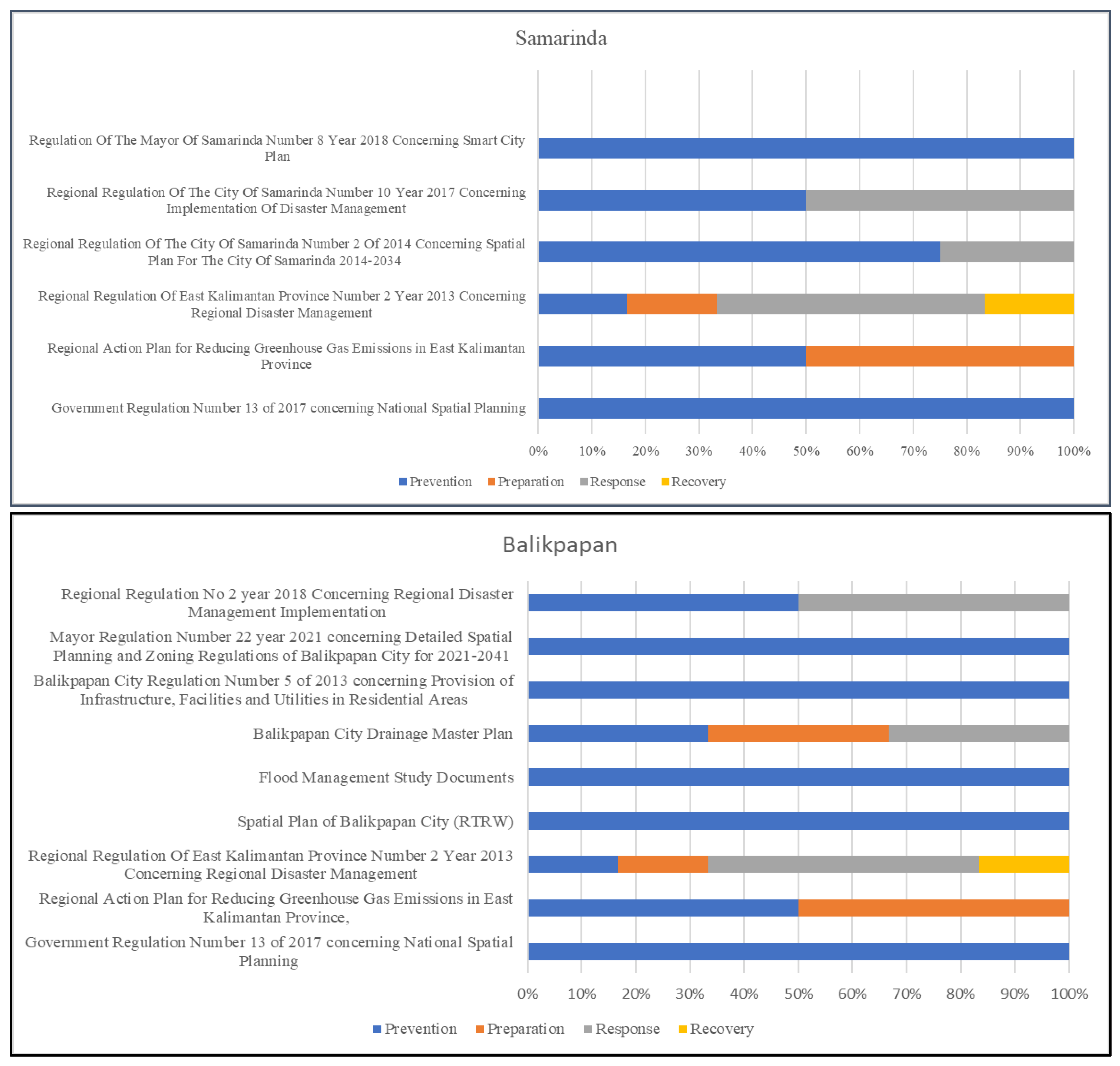
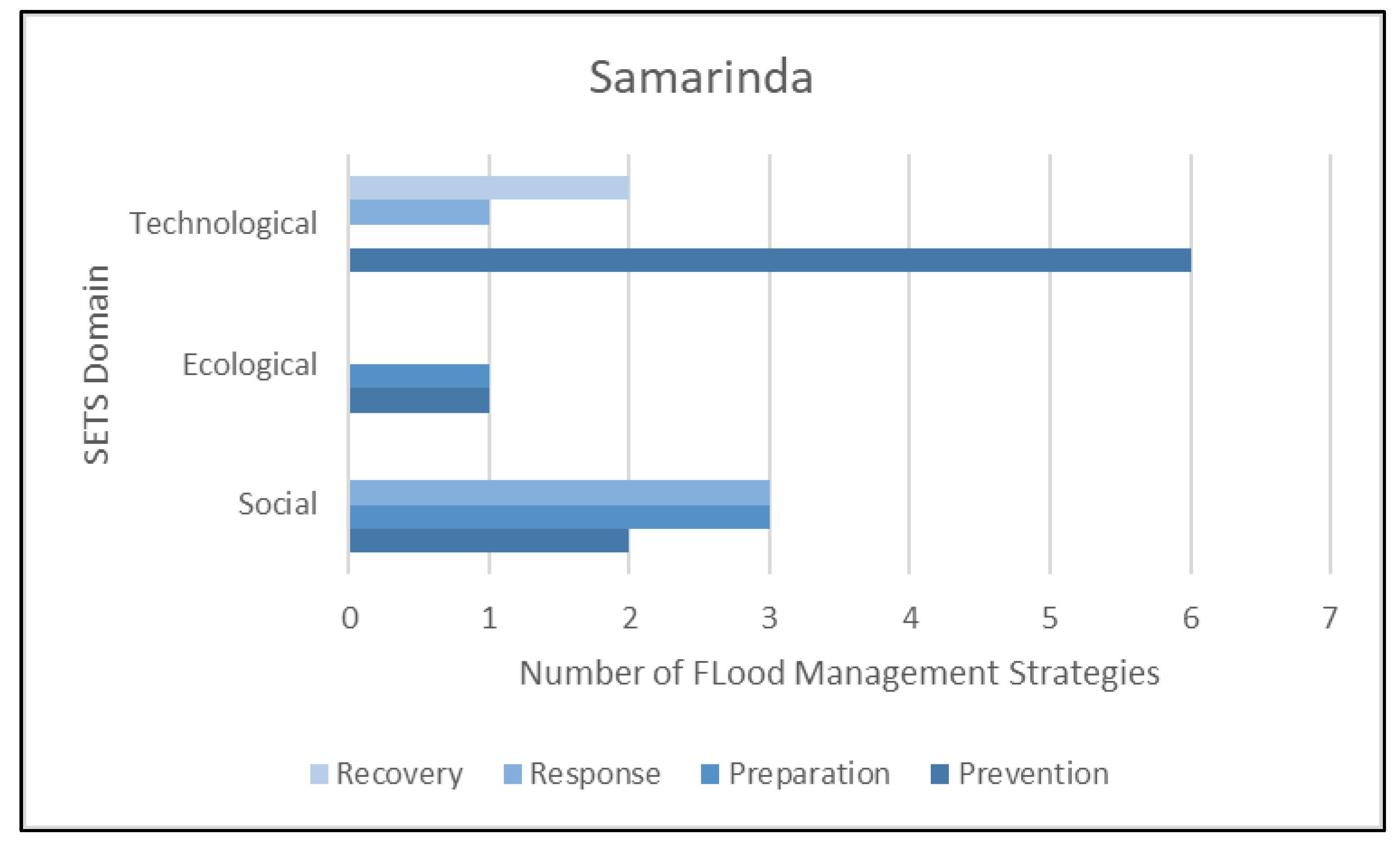
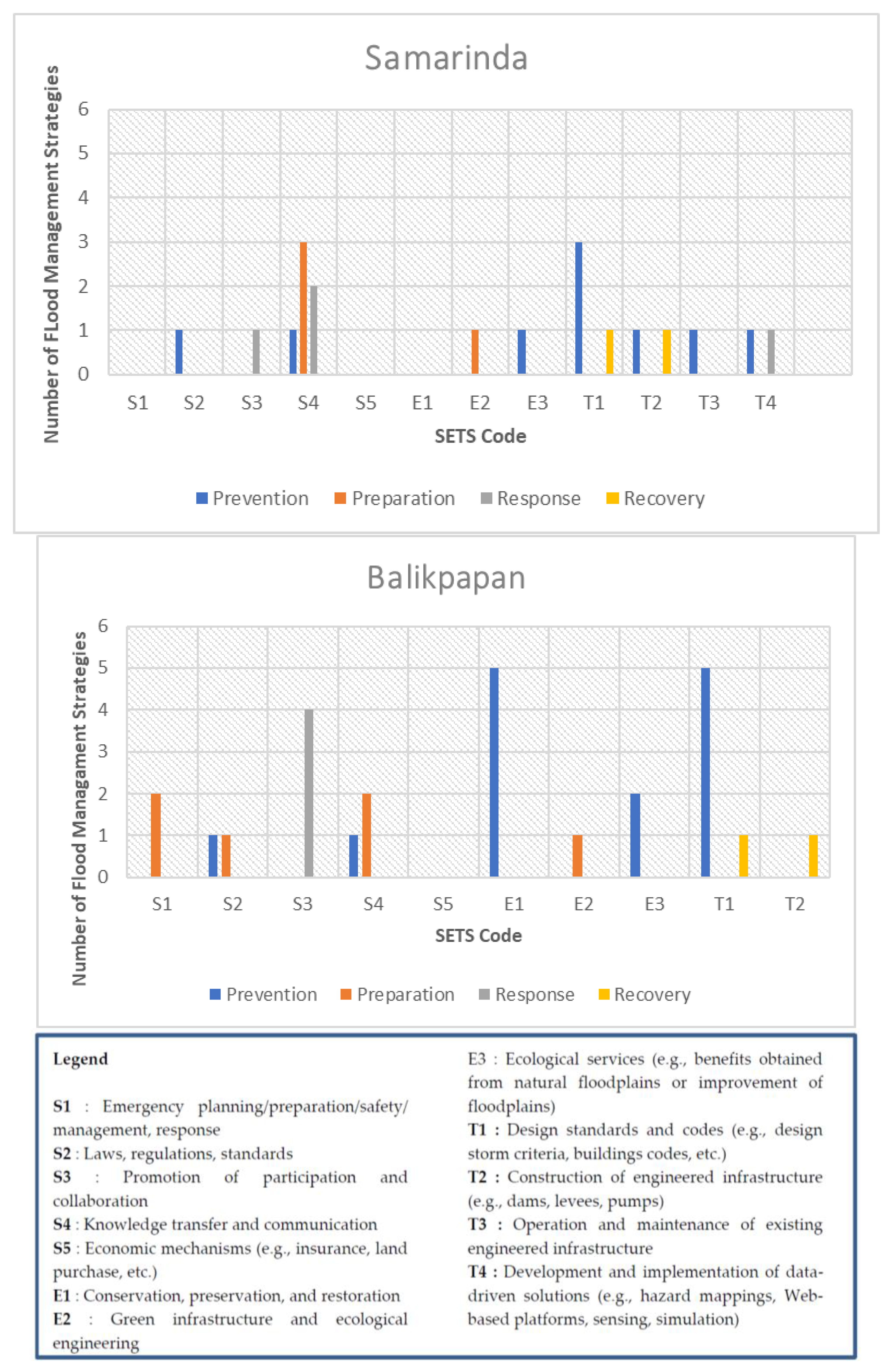
3.2. Mapping SETS and FRC in Current Flood Management Strategies

Following the identification of the SETs domain in flood management strategies, this section tries to understand these strategies using the Flood Resilience Cycle developed by Royal Haskoning [41]. The purpose is to find out the position of each city based on an adapted version of the flood resilience circle, which can be applied to enhance the cities’ resilience to flooding. There are four phases of intervention in the Flood Resilience Cycle: prevention, preparation, response, and recovery. The collected data on the flood strategies in the cities of Samarinda and Balikpapan were mapped according to the Flood Resilience Strategy (Appendix B), and their comparison can be seen in Figure 4. The two cities have almost the same approach in dealing with floods. According to the mapping, Samarinda and Balikpapan have different percentages for each resilience cycle. As for the prevention cycle, regulations have been legislated by the Mayors of Samarinda and Balikpapan, as well as the Indonesian Ministry of Public Works (MoPW). The regulations issued by the MoPW, named Zero Delta Q, need to be applied by flood-prone cities as a mandatory program.
Furthermore, both Samarinda and Balikpapan seem to be more focused on the prevention phase. It is known that every government document always has a prevention strategy. For prevention, Balikpapan has more strategies than Samarinda. However, for the response and recovery phases, these two cities have the same percentage, even though their characteristics are very different. Balikpapan is a coastal city with the majority of its area (85%) being mountainous, and Samarinda has lowlands that are nearly at the same elevation level as the river’s water level.
As per the study results shown on Figure 5, the key prevention strategies in Balikpapan’s documents are found to be retention and detention ponds, which are also found in Samarinda. These ponds are designed to absorb water. Furthermore, Balikpapan also has a master plan that designs drainage networks to mitigate flooding, whereas Samarinda prioritizes the waterfront concept to minimize flooding caused by the Karang Mumus river. Moreover, there are plans found in the documents to develop a new flood warning and forecasting system. Flood warnings are issued in both the cities, so the at-risk communities can take preventive measures to minimize the damage [64]. Remarkably, based on an interview with a local community member, it has been understood that both the selected cities lack real-time flood warnings.
In Samarinda, the response phase of flood resilience entails the establishment of a Disaster Risk Reduction Forum for flood education and information sharing in urban areas. Meanwhile, according to the documents reviewed, this type of activity has not been identified in Balikpapan. In addition, as stated in the Regional Action Plan regulation for reducing Greenhouse Gas Emissions in East Kalimantan Province, the prevention phase is seen to be only available at the provincial level. Thus, the recovery phase in Balikpapan and Samarinda is inferred to be quite limited. Correspondingly, more research and policy action are required to enhance the recovery phase and disaster resilience.
Figure 6 and Figure 7 illustrate a comparison of the Flood Resilience Cycle and SETS in the two selected cities. Although both cities emphasize prevention, the dimensions of SETS that have been implemented differ slightly. In Balikpapan, the prevention phase highlights more significantly the ecological and technological dimensions, whereas in Samarinda, the prevention phase is more focused on regarding the technological and social aspects. Figure 8 shows the distribution of each SETS code in the Flood Resilience Cycles/Phase. Based on the comparison in Figure 8, in Balikpapan, the highest at the prevention phase are the E1 and T1 codes, which stand for “Conservation, preservation, and restoration” and “Design standards and codes (e.g., design storm criteria and building codes).” It is also known that there are similarities in Samarinda, with the T1 code being the highest in the prevention phase, followed by other codes. In the recovery phase, Balikpapan and Samarinda have the same flood management strategies that are T1 and T2. In other words, these two cities only focus on technological domains for flood recovery. Balikpapan has focused on S3, which means promoting participation and collaboration in the response phase, while Samarinda has focused on S4 (knowledge transfer and communication) to deliver flood to the community. However, both Samarinda and Balikpapan have no S5 code (economic mechanism). There is no insurance, especially for disasters, provided by government.

3.3. Water Smart City Approach for Flood Resilience in Samarinda and Balikpapan City

The pillars of Indonesia 2015–2045 include smart and competitive cities for improving quality of life. Thus, all the cities aim for 100 percent of smart city indicators [30]. Additionally, the 100 Smart Cities initiative is a collaboration between the Ministries of Communication and Information, Home Affairs, Ministry of Public Works, BAPPENAS, and the Presidential Staff Office. The movement seeks to guide Regencies/Cities in developing Smart City Masterplans to optimize the use of technology in improving public services and accelerate the potential that exists in each region. Similarly, in Samarinda, it is stated in article 6 of the Samarinda Mayor’s Regulation on Smart City (2018) that one of the goals of building Samarinda Smart City is to control flooding and relocate the Karang Mumus riverbank. Furthermore, the goal of Samarinda Smart City is to increase the capacity and distribution of clean water. Meanwhile, flood management is included in Balikpapan’s 2019 smart city master plan document. Table 3 summarizes the programs in the two cities’ smart city master plans.
A water smart city can help to reduce flood risk by integrating various systems and providing real-time data. To successfully incorporate all the different systems, it is important to use an information system that can save all relevant data, including the information on hydrology and hydraulics, land management, the characteristics of various water infrastructures, and information on how these infrastructures function. In the smart city documents of both selected cities, there are only a few programs on flood disasters. Both cities focus on the early warning system that allows the local government to receive real-time reports from the public regarding incidents that occur in certain locations, including floods. The early warning system feature provides warning notifications through several channels, such as the website (desktop/command center), mobile apps, and SMS. These notifications appear when the sensor indicates an incident that has exceeded certain parameters. With reference to Section 2.2, the results of identifying SETS domains in Section 3.1, and the results of mapping and integration in Section 3.2, the authors propose an approach for implementing a smart water city as flood risk management. In addition, the general approach to water smart city is shown in Figure 9. The integration of SETS (Social–Ecological–Technological System) and Flood Resilience should be considered as a new approach for supporting smart city in each city. However, this is the proposed technical water smart city strategy for the two selected cities.
A.
Water Smart City—Ecological Domains
A key example of a measure that can help to simultaneously achieve multiple goals in the ecological domains is to increase and preserve the natural capacity of aquifers, soils, and ecosystems to retain and store water. Water quality and availability, habitat preservation, and climate change resilience can all be improved by measures such as reconnecting floodplains to rivers, re-meandering, and wetland restoration. In addition, many urban areas have implemented green roof technology to improve stormwater management by lowering peak flow rates and total amounts of rooftop runoff during heavy rains. Various conditions and design parameters (such as rainfall, soil type, building resistance, and plant species) have been studied to determine how well the green roofs retain water quantity. In periods of light to moderate rainfall, as well as during more extreme weather, green roofs can absorb large amounts of stormwater, delaying and reducing peak flows [65]. Considering the multi-faced benefits, the study strongly emphasizes the need for strengthening the prevention phase, which focuses on strengthening the ecological dimension, by installing green roofs to prevent flooding and increasing real-data-based nature characteristics for different types of floods in both the selected cities.
B.
Water Smart City—Technological Domain
In Indonesia, the embankment construction has been the most common structural method of flood control/mitigation. Flood control structures need to be operated to consider past and current flood, river, drainage system, and rainfall conditions and future predictions. Based on the radar measurements and nowcasts, an integrated model for the hydrological cycle should be used to forecast river flows and water levels in real time. Urban runoff and storm water drainage models can be created using real-time radar measurements. When it comes to dealing with flooding, the city has made a significant investment. Real-time control, model-based real-time forecasting, and operational rules can help the city to obtain the most return on its investment. Fast river runoff mitigation and water quality improvement go hand in hand. It is, therefore, necessary to have an accurate forecast system for realizing an effective flood warning system. As the warning messages need to be sent to relevant parties as quickly as possible, an effective communication system is also required.
C.
Water Smart City—Social Domain
Insurance schemes need to be considered to connect the preparation phase, while focusing on the social domain and supporting the water smart city to reduce flood risk. Balikpapan and Samarinda already have had a program to educate people in how to address risks, but external support is still needed. There are a wide variety of flood insurance policies in place across the globe, and they vary significantly in terms of coverage and risk management policies. It is therefore possible to bundle the flood insurance with coverage for other perils, such as fire, theft, or even earthquakes. The Indonesian planning system includes zoning regulations as well as land use and building codes, which can assist in reducing the risk of flooding. Flood insurance, on the other hand, can help to mitigate the economic impact of flooding.

4. Discussions

Given the importance of consistent, well-considered decision making to the viability of smart city policy, we set out to investigate the ways in which the theory and practice of SETS shifted our understanding of the role of evidence in policymaking. The integration of SETS for water smart city implementation in Indonesian cities experiencing flood disasters can help to reduce flood risk. In addition, to substantiate the findings derived through our document analysis, secondary surveys and interviews were conducted in this study to better understand the challenges in the buffer area of Indonesia’s new capital, mainly those related to flood risk and the implementation of a smart city. As per the interview results, the cities of Balikpapan and Samarinda lack adequate water capacity (rivers and drainage) and are unable to accommodate flood discharges. This is a serious problem that exists in both the selected cities. Furthermore, property developers have been transforming the open spaces into built-up area to fulfill the increasing housing demand because of populational increases, even though green open space is essential to prevent flooding in urban areas [63]. Since open green space is limited in Balikpapan and Samarinda, the two cities are likely to suffer from flooding in future. Furthermore, a study conducted by Alexander et al. in 2019 showed that the changing climate (flood driver) requires planning and implementing integrated stormwater management features into urban landscapes to ensure the protection of human life and property [66].
Remarkably, numerous best practices for reducing flood risk in ecological terms can be seen in the case of Denmark. Green areas, pocket parks, green roofs, and green walls are installed as part of Denmark’s “Adaption Imitative 2” plan to help the country in coping with the climate change by 2025. Green roofs not only hold 60% of the rain, but they also improve air quality, plant life, and wildlife habitat [54]. The amount of rainwater that runs off an asphalt road can be reduced by as much as 30% by using permeable pavement, according to a research conducted in South Korea [57,67]. The adoption of this technique is very relevant in the case of Kalimantan cities, such as Balikpapan and Samarinda, as the soil is suitable for permeable pavement. A study conducted in Samarinda shows that the local Kalimantan island material can absorb water with a maximum compression strength of 11.6 MPa with the addition of 7.5% sand [68].
It is important to note that the management of water resources involves a wide range of stakeholders, including water utilities, water authorities and regulators, and end users. Water treatment and distribution have real-time monitoring and control systems, but these systems are not effectively coordinated with each other [69]. This necessitates a framework that integrates all these applications so that they can communicate with each other in the future [46]. It indicates that preparing urban landscapes, including green open space, is critical in preventing cities from flooding [70]. However, the Public Works Department in the City of Balikpapan underlines that many developers have not built green open spaces as per the city’s Site Plan and Environmental Permit. In this case, the local government needs to strengthen the regulation regarding green space as the ecological domain for managing flood risk in both Balikpapan and Samarinda.
The Ministry of Public Works’ directive falls within the technological dimension of the SETS. Samarinda, as well as Balikpapan, have a master plan for a smart city. In both their documents, it is stated that a water smart city can be implemented to support the technological domain. However, the cities can complement and mutually assist one another by aligning their flood strategy with the three domains of SETS [23]. This confirms that flood vulnerability’s technological, social, and ecological domains are highly associated. It shows that these cities can potentially improve vulnerable environments on both the social and ecological levels. In this scenario, urban planners can construct green open spaces with a focus on adequate distribution throughout cities, while simultaneously realizing the goal of increasing social capital to increase the adaptive capacity in underprivileged neighborhoods [71].
Based on the interviews, another identified challenge is on the technological domain, namely the implementation of the sediment dredging program that is neither periodic nor comprehensive, which results in a decrease in the river’s capacity or channel. Furthermore, the monthly rainfall in Balikpapan ranges from light to moderate, with varied intensities [67]. Floods are also known to occur in Samarinda because of fluctuating rainfall [72]. However, according to SETS, the technological domain in combination with the ecological and social domains can play an essential role in addressing these difficulties. Green infrastructure, for example, demonstrates technology adaptive capacity by absorbing floodwaters and primarily filtering to support water quality [22]. However, the idea of a smart city is not always related to technological advancements; rather, it involves a shift in people’s mindsets [29,73]. Apart from the IoT water level sensor, the early warning system feature that Balikpapan and Samarinda will own is expected to allow the government to receive real-time reports from the public regarding incidents that occur in specific locations, including floods [74]. Thus, the government can make decisions quickly based on the information displayed.
The conventional method of flood control concentrates on reactive solutions, such as reducing exposure to flooding and vulnerabilities to flood damage [75]. This is accomplished primarily through structural measures, such as dykes, which involve the construction of a wall between rivers and floodplains [9,76]. On the other hand, this strategy is only partially effective because it only serves to shift the risks of flooding, rather than completely reducing them. Consequently, there is a need for a more comprehensive multi-disciplinary approach, which can result in a paradigm shift away from conventional flood control and toward intelligent flood management [77,78].
Moreover, without any water ICT standards, interoperability is hindered, which increases the cost and maintenance of such applications [24]. ICTs can be used to improve water management productivity and efficiency, maximize resource allocation using advanced information technologies for observing, storing, processing, and analyzing the system monitoring data, and presenting the analysis results. ICT-enabled solutions for managing water resources are becoming more widely available, resulting in water smart city management [79]. Local governments and other stakeholders in Balikpapan and Samarinda should accordingly incorporate IT into water management, transportation, and the environment to achieve water security at all levels (building, city, and regional) using information technology. In the policy documents of both cities, the local government has been planning to implement an early warning system, but it is identifiably too difficult to implement due to the data and real-time technology.
Additionally, there is a lack of coordination between the institutional agency or local government and overlapped tasks. For example, the Disaster Agency in Balikpapan and Samarinda underscore that their responsibility is limited to flood response rather than flood prevention. During the interview, the Disaster Agency anticipates the flood situations by monitoring the fluctuating water level. Stakeholder engagement is an essential aspect of a more inclusive and participatory type of Flood Risk Management governance [63,80,81]. Thus, it is suggested that the stakeholders and government agencies need to be mapped with SETS and Flood Resilience to better coordinate flood management in each city. In terms of ecological matters, the stakeholder’s involvement in a complex socio-environmental issue such as integrated FRM requires complex, multifaceted interactions amongst various stakeholders [76]. Furthermore, it is important to bring together urban planners, flood risk experts, and other stakeholders to enhance their awareness and raise their knowledge of collaboration and an understanding of the data and the methodologies as a first step for flood risk management.
Adaptive governance, which includes adapting and learning, is essential to achieve resilience. Herein, adaptive governance is a collaborative effort to improve the city’s adaptability capacity. Cities may strengthen their resilience and adaptability by engaging in a continual learning process [14,82]. Building consensus and accommodating the interests and needs of a wide range of stakeholders interested in spatial planning necessitates effective governance. Good governance relies heavily on the ability of institutions to adapt to changing circumstances [76]. However, every stakeholder has a role in reducing the risk of flooding. It is unlikely that the efforts of the government and the community alone will be sufficient. Individual flood prevention measures ought to be implemented, but to do so, it is first necessary to conduct the required education and perception work regarding floods. Lastly, using a questionnaire to understand community participation and time series, data can also enhance smart flood risk management by mapping flood risk [82].

5. Conclusions

Our findings on smart city integration and the SETS Framework lead us to recommend precise smart city decision making to reduce disasters (particularly flood), as well as several separate perspectives using both external and internal sources to better understand smart cities. These research methods are not limited to learning about smart city decision making based on a comprehensive approach such as SETS or FRC framework, but instead seek to improve our understanding of both theory and practice. The paper’s research findings highlight the need to be fully incorporated into future smart city policy plan, program, or policy. More precisely, in how smart city technologies can be directly implemented to achieve goals, such as the identification of urban disasters that exist in the context of a local area. Along with highlighting the disaster issues, the research also emphasizes the existing policies.
As buffer areas of the Indonesia’s new capital, Balikpapan and Samarinda are expected to be disaster-resilient, particularly for flooding. As flooding is a major problem in these two cities, it can take a serious toll on the economy. In this study, the authors tried to comprehend the SETS (Social–Ecological–Technological) system as it relates to Flood Resilience Cycle by reviewing the policy documents related to flooding and spatial planning at the national, provincial, and local levels generated mapping of flood strategies. The government database included nine documents for Balikpapan and nine documents for Samarinda. According to the findings, Balikpapan is observed to be concentrating on the technological and ecological domains, whereas Samarinda has been focusing specifically on the technological domain. Flood strategies are limited in these two cities, which result in social problems. Therefore, SETS is considered ineffective in Balikpapan and Samarinda. Several strategies for addressing the challenges are yet to be executed, even though they are typical flood management procedures, such as river capacity, drainage capacity, and soil infiltration. For instance, there has been no follow-up on installing 35 flood warning systems, even though EWS is one program in their masterplan of a smart city. Many government programs have been implemented; however, they are not shown to be effective in dealing with flooding.
The water smart city approach was suggested to achieve flood risk management based on integrating the Flood Resilience phase and SETS frameworks. Therefore, three key approaches were identified for strengthening the smart city strategies: ‘Water Smart City Management for Ecological Domains’, ‘Water Smart City Management for Technological Domains’, and ‘Water Smart City Management for Social Domains’. Since the smart cities of Balikpapan and Samarinda are still in their early stage, it is difficult to identify the challenges from the field. Due to this research limitation, more data collection and evaluating smart city masterplan are the future plans of this study.

Author Contributions

Conceptualization, A.; methodology, A.; analysis, A.; investigation, A.; writing—original draft preparation, A.; writing—review and editing, A. and R.S.; visualization, A.; supervision, R.S. All authors have read and agreed to the published version of the manuscript.

Funding

This research received no external funding.

Data Availability Statement

The data presented in this study are available upon request from the authors.

Acknowledgments

A thanks MEXT-Japan for scholarships and the Global Resilience and Innovation Laboratory (GRIL), Keio University for providing support in carrying out research.

Conflicts of Interest

The authors declare no conflict of interest.

Appendix A. List of Local Government Documents

No.Document NameStrategies Extracted and Strategy Code
Balikpapan
1Government Regulation Number 13 of 2017 concerning National Spatial PlanningZero Delta Q policy is suggested to be one of the benchmarks of successful implementations of the regional drainage system (T1)
2Regional Action Plan for Reducing Greenhouse Gas Emissions in the East Kalimantan ProvinceDevelopment of irrigation network, paddy field network (E3), and flood control facilities and infrastructure (E2)
3Regional Regulation Of the East Kalimantan Province Number 2 Year 2013 Concerning Regional Disaster ManagementConducting disaster risk analysis, monitoring and evaluation (T4), organizing disaster management education and training in accordance with its mandate and authority, based on the guidelines set by the Regional Disaster Management Agency (S4), implementing preparedness and early warning activities (S4), implementing disaster management at the post-disaster phase (rehabilitation and reconstruction) (T1,T2)
4Spatial Plan of Balikpapan (RTRW)More than a dozen flood-prone areas in Balikpapan have been identified for 13 Bendali (Flood Control Dams). However, only three city–government-owned dams have been constructed (Dam 3, Dam 4, and Wonorejo Dam) (T1)
5Flood Management Study DocumentsProvision of detention ponds with 2.5 m in depth dimension (T1). The scenario of providing detention ponds with the depth dimension of 3 m (T1) The scenario for maintaining the green area in the design year, in 2032 at least 20% and with the direction of providing a detention pond dimension of 2.5 m, (E1) maintain green cover area in planned year (2032) with minimum of 20% and with the direction of the dimensions of providing a detention pond of 3 m (E1)
6Balikpapan Drainage Master PlanDevelopment of an environmentally friendly drainage system (E3); determining priorities for handling, development, and improvement in strategic areas that are vulnerabile to inundation (S2); creating a coordination mechanism, assigning the roles and responsibilities of the government, private sector, and community in handling drainage; strengthening institutional capacity, and increasing human resources for drainage management. (S3)
7Balikpapan Regulation Number 5 of 2013 concerning Provision of Infrastructure, Facilities, and Utilities in Residential AreasBalikpapan sets 4% of the site area for the provision of green open space (E1)
8Mayor Regulation Number 22 year 2021 concerning Detailed Spatial Planning and Zoning Regulations of Balikpapan for 2021–2041Structuring the area around the reservoir (T1), reforestation around the reservoirs (E1), and revitalisation of urban slum areas (E1)
9Regional Regulation No 2 year 2018 Concerning Regional Disaster Management ImplementationDetermining areas that are vulnerable to natural disasters (floods) to be away from human settlements (S2), installation and testing of early warning system, preparation of evacuation locations (S1), develop Vulnerability Map including floods (T4)
Samarinda
1Government Regulation Number 13 of 2017 concerning National Spatial PlanningZero Delta Q policy is suggested to be one of the benchmarks of successful implementations of the regional drainage system (T1)
2Regional Action Plan for Reducing Greenhouse Gas Emissions in the East Kalimantan ProvinceDevelopment of irrigation network, paddy field network (E3),and flood control facilities and infrastructure (E2)
3Regional Regulation Of the East Kalimantan Province Number 2 Year 2013 Concerning Regional Disaster ManagementConducting disaster risk analysis, monitoring and evaluation (T4); organizing disaster management education and training in accordance withits mandate and authority, based on the guidelines set by the Regional Disaster Management Agency (S4); implementing preparedness and early warning activities (S4); implementing disaster management at the post-disaster phase (rehabilitation and reconstruction) (T1,T2)
4Regional Regulation Of The City Of Samarinda Number 2 Of 2014 Concerning Spatial Plan For The City Of Samarinda 2014–2034Implementing a flood control system by building retention and detention ponds to accommodate overflowing water (T2); providing a flood evacuation route (S4); mapping flood-vulnerable areas (T4); developing a program to improve the drainage system in flood-vulnerable areas with a tiered and integrated system (S2)
5Regional Regulation Of The City Of Samarinda Number 10 Year 2017 Concerning Implementation Of Disaster ManagementEstablishing a Disaster Risk Reduction Forum (S3); organizing education and training activities at formal, non-formal and informal levels aimed to increase awareness, concern, capability, as well as Community Preparedness in dealing with disasters (S4); implementation and enforcement of building construction provisions (T1); development of spatial planning based on Disaster Risk analysis (T1)
6Regulation Of The Mayor Of Samarinda Number 8 Year 2018 Concerning The Samarinda Smart City MasterplanOrganizing the banks of the Karang Mumus River to support flood control and the Waterfront City concept (T3) and Optimizing land management to cope flooding (S2)

Appendix B. Mapping SETS and Flood Resilience in Samarinda and Balikpapan

PreventionPreparationResponseRecovery
BalikpapanZero Delta Q policy (T1)Flood control facilities and infrastructure (E2)Conducting disaster risk analysis, monitoring and evaluation (T4)Implementing disaster management at the post-disaster stage (rehabilitation and reconstruction) (T1,T2)
Development of irrigation network, paddy field network (E3)Implementing of preparedness and early warning activities (S4)Create a coordination mechanism; determine the roles and responsibilities of the government, the private sector, and the community in handling drainage; strengthen institutional capacity; and increase human resources for drainage management (S3)
Organizing disaster management education and training (S4)Organizing disaster management education and training (S4)
More than a dozen flood-vulnerability areas in Balikpapan have been designated for 13 Bendali (Flood Control Dams) (T1)Determine priorities for flood handling, development, and improvement in strategic areas vulnerability to inundation (S2)
Provision of detention ponds with the direction of the depth dimension of the detention pond being 2.5 m (T1)Installation and testing of early warning system; preparation of evacuation locations (S1)
The scenario of providing detention ponds with the direction of the depth dimension of the detention pond is 3 m (T1)
The scenario for maintaining the green cover area in the design year, in 2032 at least 20% and with the direction of providing a detention pond dimension of 2.5 m (E1)
Maintain green cover area in plan year (2032) with minimum of 20% and with the direction of the dimensions of providing a detention pond of 3 m (E1)
Development of an environmentally friendly drainage system (E3)
Balikpapan sets 4% of the site area for the provision of green open space (E1)
Structuring the area around the reservoir (T1)
Reforestation around reservoirs (E1)
Revitalization of urban slum areas (E1)
Determine areas vulnerability to natural disasters (floods) far from settlements (S2)
Develop Vulnerability Map including Flood (T4)
SamarindaZero Delta Q policy (T1)Flood control facilities and infrastructure (E2)Conducting disaster risk analysis, monitoring and evaluation (T4)Implementing disaster management at the post-disaster stage (rehabilitation and reconstruction) (T1,T2)
Development of irrigation network, paddy field network (E3)Organizing disaster management education and training (S4)Implementing preparedness and early warning activities (S4)
Organizing disaster management education and training (S4)Implementing of preparedness and early warning activities (S4)Providing a flood evacuation route (S4)
Implementing a flood control system by built retention ponds and detention ponds to accommodate overflowing water (T2) Organizing education and training activities at formal, non-formal, and informal levels aimed at increasing awareness, concern, capability, and Community Preparedness in dealing with disasters (S4)Establishing a Disaster Risk Reduction Forum (S3)
Mapping flood-vulnerability areas (T4)
Develop a program to improve the drainage system in flood-vulnerability areas with a tiered and integrated system (S2)
Implementation and enforcement of building construction provisions (T1)
Develop spatial planning based on Disaster Risk analysis (T1)
Organizing the banks of the Karang Mumus River to support flood control and the Waterfront City concept (T3)
Optimization of land management to cope flooding (S2)

References

  1. Ruffer, D.G. Effect of Flooding on a Population of Mice. J. Mammal. 1961, 42, 494–502. [Google Scholar] [CrossRef]
  2. Chang, L.F.; Huang, S.L. Assessing urban flooding vulnerability with an emergy approach. Landsc. Urban Plan. 2015, 143, 11–24. [Google Scholar] [CrossRef]
  3. Sholihah, Q.; Kuncoro, W.; Wahyuni, S.; Puni Suwandi, S.; Dwi Feditasari, E. The analysis of the causes of flood disasters and their impacts in the perspective of environmental law. IOP Conf. Ser. Earth Environ. Sci. 2020, 437, 012056. [Google Scholar] [CrossRef]
  4. Ahilan, S.; Guan, M.; Sleigh, A.; Wright, N.; Chang, H. The influence of floodplain restoration on flow and sediment dynamics in an urban river. J. Flood Risk Manag. 2018, 11, S986–S1001. [Google Scholar] [CrossRef]
  5. United Nations Office for Disaster Risk Reduction. Sendai Framework for Disaster Risk Reduction 2015–2030; The United Nations Office for Disaster Risk Reduction: Geneva, Switzerland, 2015. [Google Scholar]
  6. United Nations Office for Disaster Risk Reduction; Centre for Research on the Epidemiology of Disasters. The Human Cost of Weather-Related Disasters 1995–2015; Report; The UN Office for Disaster Risk Reduction: Geneva, Switzerland, 2015. [Google Scholar]
  7. Konrad, C.P. Effects of Urban Development on Floods; USGS Fact Sheet FS-076-03; USGS: Reston, VA, USA, 2003.
  8. Hapsari, R.I.; Zenurianto, M. View of Flood Disaster Management in Indonesia and the Key Solutions. Am. J. Eng. Res. 2016, 5, 140–151. [Google Scholar]
  9. Dwirahmadi, F.; Rutherford, S.; Phung, D.; Chu, C. Understanding the operational concept of a flood-resilient urban community in Jakarta, Indonesia, from the perspectives of disaster risk reduction, climate change adaptation and development agencies. Int. J. Environ. Res. Public Health 2019, 16, 3993. [Google Scholar]
  10. Tarigan, A.K.M.; Samsura, D.A.A.; Sagala, S.; Wimbardana, R. Balikpapan: Urban planning and development in anticipation of the post-oil industry era. Cities 2017, 60, 246–259. [Google Scholar] [CrossRef]
  11. Wardhana, I.G. Enhancing Resilience in Balikpapan as Buffer Zone for the New Capital City of Indonesia. Master’s Thesis, University of Groningen, Groningen, The Netherlands, 2021. [Google Scholar]
  12. Aerts, J.C.J.H.; Botzen, W.J.W.; Emanuel, K.; Lin, N.; De Moel, H.; Michel-Kerjan, E.O. Climate adaptation: Evaluating flood resilience strategies for coastal megacities. Science 2014, 344, 473–475. [Google Scholar] [CrossRef]
  13. Singh, P.; Amekudzi-Kennedy, A.; Woodall, B.; Joshi, S. Lessons from case studies of flood resilience: Institutions and built systems. Transp. Res. Interdiscip. Perspect. 2021, 9, 100297. [Google Scholar] [CrossRef]
  14. Moloney, S.; Fünfgeld, H. Emergent processes of adaptive capacity building: Local government climate change alliances and networks in Melbourne. Urban Clim. 2015, 14, 30–40. [Google Scholar] [CrossRef]
  15. Chmutina, K.; Lizarralde, G.; Dainty, A.; Bosher, L. Unpacking resilience policy discourse. Cities 2016, 58, 70–79. [Google Scholar] [CrossRef]
  16. Auliagisni, W.; Wilkinson, S.; Elkharboutly, M. Using community-based flood maps to explain flood hazards in Northland. N. Z. Prog. Disaster Sci. 2022, 14, 100229. [Google Scholar] [CrossRef]
  17. Maimunah, S.; Rosli, N.S.; Rafanoharana, S.; Sari, K.R.; Higashi, O. Strengthening Community to Prevent Flood Using Participatory Approach: A case of Semarang City, Indonesia. J. Int. Dev. Coop. 2011, 18, 19–28. [Google Scholar]
  18. Grimm, N.B.; Pickett, S.T.A.; Hale, R.L.; Cadenasso, M.L. Does the ecological concept of disturbance have utility in urban social–ecological–technological systems? Ecosyst. Health Sustain. 2017, 3, e01255. [Google Scholar] [CrossRef]
  19. Markolf, S.A.; Chester, M.V.; Eisenberg, D.A.; Iwaniec, D.M.; Davidson, C.I.; Zimmerman, R.; Miller, T.R.; Ruddell, B.L.; Chang, H. Interdependent Infrastructure as Linked Social, Ecological, and Technological Systems (SETSs) to Address Lock-in and Enhance Resilience. Earth’s Future 2018, 6, 1638–1659. [Google Scholar] [CrossRef]
  20. van Hattum, T.; Blauw, M.; Bergen Jensen, M.; de Bruin, K. Towards Water Smart Cities. Wageningen Environ. Res. Rapp. 2016, 60, 2787. Available online: https://edepot.wur.nl/407327 (accessed on 12 January 2022).
  21. Hamstead, Z.; Iwaniec, D.; McPhearson, T.; Berbés-Blázquez, M.; Cook, E.M.; Muñoz-Erickson, T.A. Resilient Urban Futures; Springer: Berlin/Heidelberg, Germany, 2021. [Google Scholar]
  22. Cheng, C.; Yang, Y.C.E.; Ryan, R.; Yu, Q.; Brabec, E. Assessing climate change-induced flooding mitigation for adaptation in Boston’s Charles River watershed. USA. Landsc. Urban Plan. 2017, 167, 25–36. [Google Scholar] [CrossRef]
  23. Chang, H.; Pallathadka, A.; Sauer, J.; Grimm, N.B.; Herreros-Cantis, P. Assessment of urban flood vulnerability using the social-ecological-technological systems framework in six US cities. Sustain. Cities Soc. 2021, 68, 102786. [Google Scholar] [CrossRef]
  24. Gade, D.S. Reinventing Smart Water Management System through ICT and IoT Driven Solution for Smart Cities. Int. J. Appl. Eng. Manag. Lett. 2021, 5, 132–151. [Google Scholar] [CrossRef]
  25. Keshavarzi, G.; Yildirim, Y.; Arefi, M. Does scale matter? An overview of the ‘smart cities’ literature. Sustain. Cities Soc. 2021, 74, 103151. [Google Scholar] [CrossRef]
  26. Kitchin, R. The real-time city? Big data and smart urbanism. Geo. J. 2014, 79, 1–14. [Google Scholar] [CrossRef]
  27. Oberascher, M.; Rauch, W.; Sitzenfrei, R. Towards a smart water city: A comprehensive review of applications. data requirements, and communication technologies for integrated management. Sustain. Cities Soc. 2022, 76, 103442. [Google Scholar] [CrossRef]
  28. Sukhwani, V.; Shaw, R.; Deshkar, S.; Mitra, B.K.; Yan, W. Role of smart cities in optimizing water-energy-food nexus: Opportunities in Nagpur, India. Smart Cities 2020, 3, 1266–1292. [Google Scholar] [CrossRef]
  29. Araos, M.; Berrang-Ford, L.; Ford, J.D.; Austin, S.E.; Biesbroek, R.; Lesnikowski, A. Climate change adaptation planning in large cities: A systematic global assessment. Environ. Sci. Policy 2016, 66, 375–382. [Google Scholar] [CrossRef]
  30. Syalianda, S.I.; Kusumastuti, R.D. Implementation of smart city concept: A case of Jakarta Smart City, Indonesia. IOP Conf. Ser. Earth Environ. Sci. 2021, 716, 012128. [Google Scholar] [CrossRef]
  31. Muñoz-Erickson, T.A.; Miller, C.A.; Miller, T.R. How cities think: Knowledge co-production for urban sustainability and resilience. Forests 2017, 8, 203. [Google Scholar] [CrossRef]
  32. Folke, C.; Hahn, T.; Olsson, P.; Norberg, J. Adaptive governance of social-ecological systems. Annu. Rev. Environ. Resour. 2005, 30, 441–473. [Google Scholar] [CrossRef]
  33. Carmin, J.; Anguelovski, I.; Roberts, D. Urban Climate Adaptation in the Global South: Planning in an Emerging Policy Domain. J. Plan. Educ. Res. 2012, 32, 18–32. [Google Scholar] [CrossRef]
  34. Fisher, L. Disaster responses: More than 70 ways to show resilience. Nature 2015, 518, 35. [Google Scholar] [CrossRef]
  35. Cutter, S.L.; Ahearn, J.A.; Amadei, B.; Crawford, P.; Eide, E.A.; Galloway, G.E.; Goodchild, M.F.; Kunreuther, H.C.; Li-Vollmer, M.; Schoch-Spana, M.; et al. Disaster resilience: A national imperative. Environment 2013, 55, 25–29. [Google Scholar] [CrossRef]
  36. Basabe, P. Hyogo framework for action 2005–2015. In Encyclopedia of Earth Sciences Series; Bobrowsky, P.T., Ed.; Springer: Dordrecht, The Netherlands, 2013; pp. 508–516. [Google Scholar]
  37. Cosco, T.D.; Kaushal, A.; Hardy, R.; Richards, M.; Kuh, D.; Stafford, M. Operationalising resilience in longitudinal studies: A systematic review of methodological approaches. J. Epidemiol. Community Health 2017, 71, 98–104. [Google Scholar] [CrossRef] [PubMed]
  38. Attolico, A.; Smaldone, R. The #weResilient strategy for downscaling local resilience and sustainable development: The Potenza province and municipalities of Potenza and Pignola case. Disaster Prev. Manag. Int. J. 2020, 29, 793–810. [Google Scholar]
  39. Kim, N.W.; Lee, J.Y.; Park, D.H.; Kim, T.W. Evaluation of future flood risk according to rcp scenarios using a regional flood frequency analysis for ungauged watersheds. Water 2019, 11, 992. [Google Scholar] [CrossRef]
  40. Herdiyanti, A.; Hapsari, P.S.; Susanto, T.D. Modelling the smart governance performance to support smart city program in Indonesia. Procedia Comput. Sci. 2019, 161, 367–377. [Google Scholar] [CrossRef]
  41. Adedeji, T.; Proverbs, D.; Xiao, H.; Cobbing, P.; Oladokun, V. Making Birmingham a flood resilient city: Challenges and opportunities. Water 2019, 11, 1699. [Google Scholar] [CrossRef] [Green Version]
  42. Yazdani, M.; Mojtahedi, M.; Loosemore, M.; Sanderson, D.; Dixit, V. An integrated decision model for managing hospital evacuation in response to an extreme flood event: A case study of the Hawkesbury-Nepean River. Saf. Sci. 2022, 155, 105867. [Google Scholar] [CrossRef]
  43. Heinzlef, C.; Robert, B.; Hémond, Y.; Serre, D. Operating urban resilience strategies to face climate change and associated risks: Some advances from theory to application in Canada and France. Cities 2020, 104, 102762. [Google Scholar] [CrossRef]
  44. Kitchin, R. Making sense of smart cities: Addressing present shortcomings. Cambridge J. Reg. Econ. Soc. 2015, 8, 131–136. [Google Scholar] [CrossRef]
  45. Yang, C.; Daigger, G.T.; Belia, E.; Kerkez, B. Extracting useful signals from flawed sensor data: Developing hybrid data-driven approaches with physical factors. Water Res. 2020, 185, 116282. [Google Scholar] [CrossRef]
  46. Newhart, K.B.; Holloway, R.W.; Hering, A.S.; Cath, T.Y. Data-driven performance analyses of wastewater treatment plants: A review. Water Res. 2019, 157, 498–513. [Google Scholar] [CrossRef] [PubMed]
  47. Mollerup, A.L.; Mikkelsen, P.S.; Thornberg, D.; Sin, G. Controlling sewer systems—A critical review based on systems in three EU cities. Urban Water J. 2017, 14, 435–442. [Google Scholar] [CrossRef]
  48. Yuan, Z.; Olsson, G.; Cardell-Oliver, R.; van Schagen, K.; Marchi, A.; Deletic, A.; Urich, C.; Rauch, W.; Liu, Y.; Jiang, G. Sweating the assets—The role of instrumentation, control and automation in urban water systems. Water Res. 2019, 155, 381–402. [Google Scholar] [CrossRef] [PubMed]
  49. Creaco, E.; Campisano, A.; Fontana, N.; Marini, G.; Page, P.R.; Walski, T. Real time control of water distribution networks: A state-of-the-art review. Water Res. 2019, 161, 517–530. [Google Scholar] [CrossRef]
  50. Wasko, C.; Westra, S.; Nathan, R.; Orr, H.G.; Villarini, G.; Herrera, R.V.; Fowler, H.J. Incorporating climate change in flood estimation guidance. Philos. Trans. R. Soc. A Math. Phys. Eng. Sci. 2021, 379, 20190548. [Google Scholar] [CrossRef]
  51. Ramos, H.M.; Carravetta, A.; McNabola, A.; Adeyeye, K. Environmental hydraulics research. Water 2020, 12, 2749. [Google Scholar] [CrossRef]
  52. Sinha, K.; Srivastava, D.K.; Bhatnagar, R. Water Quality Management through Data Driven Intelligence System in Barmer Region, Rajasthan. Procedia Comput. Sci. 2018, 132, 314–322. [Google Scholar] [CrossRef]
  53. Garau, C.; Pavan, V.M. Evaluating urban quality: Indicators and assessment tools for smart sustainable cities. Sustainability 2018, 10, 575. [Google Scholar] [CrossRef]
  54. Ler, L.G. Flood Resilience and Smart Water Management: Implementation Strategies for Smart Cities. Doctoral Dissertation, Université Côte d’Azur, Nice, France, Université nationale d’Incheon, Incheon, Korea, October 2018. [Google Scholar]
  55. Ramos, H.M.; McNabola, A.; López-Jiménez, P.A.; Pérez-Sánchez, M. Smart Water Management towards Future Water. Water 2019, 12, 58. [Google Scholar] [CrossRef]
  56. Ewing, G.; Demir, I. An ethical decision-making framework with serious gaming: A smart water case study on flooding. J. Hydroinform. 2021, 23, 466–482. [Google Scholar] [CrossRef]
  57. Mullapudi, A.; Wong, B.P.; Kerkez, B. Emerging investigators series: Building a theory for smart stormwater systems. Environ. Sci. Water Res. Technol. 2017, 3, 66–77. [Google Scholar] [CrossRef]
  58. Babel, M.S.; Shinde, V.R.; Sharma, D.; Dang, N.M. Measuring water security: A vital step for climate change adaptation. Environ. Res. 2020, 185, 109400. [Google Scholar] [CrossRef] [PubMed]
  59. Yildirim, E.; Demir, I. An integrated web framework for HAZUS-MH flood loss estimation analysis. Nat. Hazards 2019, 99, 275–286. [Google Scholar] [CrossRef]
  60. Ariyaningsih; Erik, B.; Sukmara, B. Kriteria ketahanan kota berdasarkan jenis bencana prioritas di Kota Balikpapan. Reg. J. Pembang. Wil. dan Perenc. Partisipatif 2021, 16, 74–82. [Google Scholar] [CrossRef]
  61. Benny Sukmara, R.; Shyan Wu, R. Resources and Ecological Conservation Management in Samarinda, Indonesia: Recent Progress. In Proceedings of the 20th Cross-Strait Symposium on Environment, Chiayi, Taiwan, 16–22 June 2019. [Google Scholar] [CrossRef]
  62. Berbés-Blázquez, M.; Mitchell, C.L.; Burch, S.L.; Wandel, J. Understanding climate change and resilience: Assessing strengths and opportunities for adaptation in the Global South. Clim. Chang. 2017, 141, 227–241. [Google Scholar] [CrossRef]
  63. Brody, S.D.; Highfield, W.E.; Blessing, R.; Makino, T.; Shepard, C.C. Evaluating the effects of open space configurations in reducing flood damage along the Gulf of Mexico coast. Landsc. Urban Plan. 2017, 167, 225–231. [Google Scholar] [CrossRef]
  64. Russo, B.; Velasco, M.; Locatelli, L.; Sunyer, D.; Yubero, D.; Monjo, R.; Martínez-Gomariz, E.; Forero-Ortiz, E.; Sánchez-Muñoz, D.; Evans, B.; et al. Assessment of urban flood resilience in barcelona for current and future scenarios. The RESCCUE Project. Sustainability 2020, 12, 5638, Erratum in Sustainability 2020, 12, 9875. [Google Scholar] [CrossRef]
  65. Jhong, B.C.; Tachikawa, Y.; Tanaka, T.; Udmale, P.; Tung, C.P. A generalized framework for assessing flood risk and suitable strategies under various vulnerability and adaptation scenarios: A case study for residents of Kyoto City in Japan. Water 2020, 12, 2508. [Google Scholar] [CrossRef]
  66. Alexander, K.; Hettiarachchi, S.; Ou, Y.; Sharma, A. Can integrated green spaces and storage facilities absorb the increased risk of flooding due to climate change in developed urban environments? J. Hydrol. 2019, 579, 124201. [Google Scholar] [CrossRef]
  67. Ariyaningsih; Sukhwani, V.; Shaw, R. Vulnerability assessment of Balikpapan (Indonesia) for climate change-induced urban flooding. Int. J. Disaster Resil. Built Environ. 2022; ahead-of-print. [Google Scholar] [CrossRef]
  68. Pranoto, Y.; Sudibyo, A.; Rivelda, E.R. Experimental Study of Porous Paving Using Kalimantan Local Materials. In Proceedings of the 2nd Borobudur International Symposium on Science and Technology (BIS-STE 2020), online, 18 November 2020; Atlantis Press: Amsterdam, The Netherlands, 2021; Volume 203, pp. 144–147. [Google Scholar]
  69. Jones, C.S.; Davis, C.A.; Drake, C.W.; Schilling, K.E.; Debionne, S.H.; Gilles, D.W.; Demir, I.; Weber, L.J. Iowa Statewide Stream Nitrate Load Calculated Using In Situ Sensor Network. J. Am. Water Resour. Assoc. 2018, 54, 471–486. [Google Scholar] [CrossRef]
  70. Moon, Y.I.; Choi, J.H.; Kim, M.S.; Lee, J.H. Flood forecasting system of urban areas in SOUTH KOREA. Int. J. Saf. Secur. Eng. 2017, 7, 213–220. [Google Scholar] [CrossRef]
  71. Chang, H.; Yu, D.J.; Markolf, S.A.; Hong, C.Y.; Eom, S.; Song, W.; Bae, D. Understanding Urban Flood Resilience in the Anthropocene: A Social–Ecological–Technological Systems (SETS) Learning Framework. Ann. Am. Assoc. Geogr. 2020, 111, 837–857. [Google Scholar]
  72. Ghozali, A.; Ariyaningsih; Sukmara, R.B.; Aulia, B.U. A Comparative Study of Climate Change Mitigation and Adaptation on Flood Management between Ayutthaya City (Thailand) and Samarinda City (Indonesia). Procedia Soc. Behav. Sci. 2016, 227, 424–429. [Google Scholar] [CrossRef]
  73. De Angeli, S.; Malamud, B.D.; Rossi, L.; Taylor, F.E.; Trasforini, E.; Rudari, R. A multi-hazard framework for spatial-temporal impact analysis. Int. J. Disaster Risk Reduct. 2022, 73, 102829. [Google Scholar] [CrossRef]
  74. Setiawan, I.; Ilham, M.; Nawawi, M. Smart Governance Implementation in Balikpapan City. East Kalimantan. J. Borneo Kalimantan 2020, 6, 22–34. [Google Scholar] [CrossRef]
  75. Thanvisitthpon, N.; Shrestha, S.; Pal, I. Urban Flooding and Climate Change: A Case Study of Bangkok, Thailand. Environ. Urban. ASIA 2018, 9, 86–100. [Google Scholar] [CrossRef]
  76. Blázquez, L.; García, J.A.; Bodoque, J.M. Stakeholder analysis: Mapping the river networks for integrated flood risk management. Environ. Sci. Policy 2021, 124, 506–516. [Google Scholar] [CrossRef]
  77. Serra-Llobet, A.; Conrad, E.; Schaefer, K. Governing for integrated water and flood risk management: Comparing top-down and bottom-up approaches in Spain and California. Water 2016, 8, 445. [Google Scholar] [CrossRef]
  78. Roggema, R. Towards enhanced resilience in city design: A proposition. Land 2014, 3, 460–481. [Google Scholar] [CrossRef]
  79. Feofilovs, M.; Romagnoli, F.; Gotangco, C.K.; Josol, J.C.; Jardeleza, J.M.P.; Litam, J.E.; Campos, J.I.; Abenojar, K. Assessing resilience against floods with a system dynamics approach: A comparative study of two models. Int. J. Disaster Resil. Built Environ. 2020, 11, 615–629. [Google Scholar] [CrossRef]
  80. Rüttinger, L.; Sharma, V. Climate Change and mining A Foreign Policy Perspective legal notice. Guideb. Eval. Min. Proj. EIAs 2016, 63, 45. [Google Scholar]
  81. Tierolf, L.; de Moel, H.; van Vliet, J. Modeling urban development and its exposure to river flood risk in Southeast Asia. Comput. Environ. Urban Syst. 2021, 87, 101620. [Google Scholar] [CrossRef]
  82. Agonafir, C.; Pabon, A.R.; Lakhankar, T.; Khanbilvardi, R.; Devineni, N. Understanding New York City street flooding through 311 complaints. J. Hydrol. 2022, 605, 127300. [Google Scholar] [CrossRef]
Figure 1. Research framework (Source: authors).
Smartcities 05 00067 g001
Figure 2. Distribution of the SETS dimensions in Balikpapan and Samarinda (Source: authors).
Smartcities 05 00067 g002
Figure 3. SETS code in the local government documents (Source: authors).
Smartcities 05 00067 g003
Figure 4. Flood management strategies in government documents as per the flood resilience phase.
Smartcities 05 00067 g004
Figure 5. Distribution of flood resilience strategies in the selected local government documents in Samarinda and Balikpapan.
Smartcities 05 00067 g005
Figure 6. Flood Resilience Phase for SETS domains in Samarinda (Source: authors).
Smartcities 05 00067 g006
Figure 7. Flood Resilience Phase for the SETS domains in Balikpapan (Source: authors).
Smartcities 05 00067 g007
Figure 8. Comparison of SETS code in each Flood Resilience Phase (Source: authors).
Smartcities 05 00067 g008
Figure 9. Water smart city approach in Balikpapan and Samarinda (Source: authors).
Smartcities 05 00067 g009
Table 1. SETS domains and codes.
SETS DomainCategorySETS Code
SocialEmergency planning/preparation/safety/management, responseS1
Laws, regulations, and standardsS2
Promotion of participation and collaborationS3
Knowledge transfer and communicationS4
Economic mechanisms (e.g., insurance and land purchase)S5
EcologicalConservation, preservation, and restorationE1
Green infrastructure and ecological engineeringE2
Ecological services (e.g., benefits obtained from natural floodplains or improvement of floodplains)E3
TechnologicalDesign standards and codes (e.g., design storm criteria and buildings codes)T1
Construction of engineered infrastructure (e.g., dams, levees, and pumps)T2
Operation and maintenance of existing engineered infrastructureT3
Development and implementation of data-driven solutions (e.g., hazard
Mappings, Web-based platforms, sensing, and simulation)
T4
(Source: modified by authors from Hamstead et al., 2021) [21].
Table 2. Selected city characteristics.
AspectsBalikpapanSamarinda
Temperature (average)31 degrees Celsius33 degrees Celsius
Population688,318 people827,994 people
Flood events (2021)3066
Area503.3 km²717.4 km²
Major cause of floodHeavy precipitationHeavy precipitation
TopographyCoastal city, 85% of the area is hillyTopography of lowlands crossed by rivers
Table 3. Summary of smart city masterplan regarding disaster management in Balikpapan and Samarinda.
AspectsBalikpapanSamarinda
Smart Living
  • Early Warning System Development for flood and landslides based on information technology and communication
  • Utilization of sensor technology on the Internet of Things (IoT) in reporting and monitoring water and air pollution
Early Warning System Development for Flood Risk
Smart Branding
  • Developing Tourism Branding for Balikpapan and New Capital City
  • Creating a livable city with resilience to disasters
Implementing waterfront city concept by building infrastructures to face the flood problem
Smart EnvironmentDeveloping Strategies for Supporting Sustainable Development Goals in BalikpapanDevelopment of drainage systems and riverbank management
Smart SocietyEnhancing community capacity for adapting to disasterSocializing utilization of Early Warning System for Local Community
Source: Smart City of Masterplan Balikpapan (2019) and Smart City Masterplan of Samarinda (2018).
Publisher’s Note: MDPI stays neutral with regard to jurisdictional claims in published maps and institutional affiliations.

