1. Introduction
Forest fires pose a growing threat worldwide, inflicting severe damage on ecosystems, biodiversity, infrastructure, and human life [
1]. While natural fires have historically contributed to ecological renewal, recent decades have seen a dramatic increase in both the frequency and intensity of wildfires [
2]. In Canada, the 2023 wildfire season was the most catastrophic ever recorded, with over 6000 fires consuming more than 15 million hectares, primarily boreal forest, along with peatlands, mixed wood forests, and some grasslands [
3]. This burned area, which far exceeds the size of England, is more than twice the previous record set in 1989 and dwarfs the historical annual average of 2 million hectares burned [
4].
Unprecedented in scale and geographic spread, these fires impacted nearly every region, from British Columbia to the Atlantic provinces and even the North, with 29 mega-fires (>100,000 hectares) active by mid-July [
5]. This escalation is closely linked to climate change, which is altering weather patterns in ways that create more favorable conditions for wildfires. In addition to climatic influences, anthropogenic factors, such as land use changes, population density, and human-induced ignition sources (e.g., agricultural burning, power lines, and recreational activities) also play a critical role in increasing forest fire risk [
6]. These human-driven contributions further compound the effects of climate change, leading to more frequent and severe wildfire events. Moreover, higher global temperatures result in drier environments, as they increase evaporation rates from soil and vegetation, leading to conditions ripe for ignition [
7]. Additionally, climate change is causing more frequent and severe droughts, which further dry out forests, making them highly flammable. Shifts in vegetation types due to changing climate conditions can also lead to an increase in highly flammable plant species, while the increased frequency of extreme weather events, such as heatwaves and lightning storms, directly triggers fires or creates conditions conducive to their spread.
In response to this escalating threat, machine learning (ML) and deep learning (DL) have emerged as transformative tools for forest fire prediction and early detection [
8,
9]. These data-driven models can analyze heterogeneous data sources, such as weather patterns, vegetation indices, and topography to identify complex, nonlinear relationships that inform risk assessment [
10]. For example, ML and DL algorithms can model and predict forest fire risks by identifying patterns and correlations not immediately apparent to human analysts [
10]. Remote sensing technologies, such as Sentinel-3, have also played a vital role in enhancing fire detection accuracy by providing high-resolution thermal and optical data, enabling real-time monitoring both during the day and at night. Integrating such data with ML and DL models can further improve the spatiotemporal precision of fire prediction systems [
11]. These predictive models can provide early warnings of high-risk conditions, allowing authorities to take preventive measures such as issuing public alerts, enforcing fire bans, and strategically deploying firefighting resources. Moreover, by integrating climate change projections into predictive models, ML and DL can forecast long-term changes in fire risk, aiding in better planning and adaptation strategies [
12].
For real-time fire detection and monitoring, ML- and DL-based systems are integrated with satellite imagery, drones, and ground-based sensors to detect fires in real time by identifying signs such as smoke and heat signatures [
13]. Early detection is crucial for preventing small fires from escalating into large, uncontrollable blazes [
14]. Automated detection systems can almost instantaneously alert firefighting teams and other stakeholders, enabling rapid response times [
15]. Continuous monitoring and analysis of fire behavior and environmental conditions also support data-driven decision-making during firefighting operations [
16]. ML models can simulate different scenarios and suggest the most effective strategies for fire suppression and containment. These systems enable alerts to emergency responders, significantly reducing the time between ignition and response. Furthermore, data-driven simulation models can predict fire behavior and guide tactical decisions in suppression operations. This capability enhances the resilience of both natural ecosystems and human settlements.
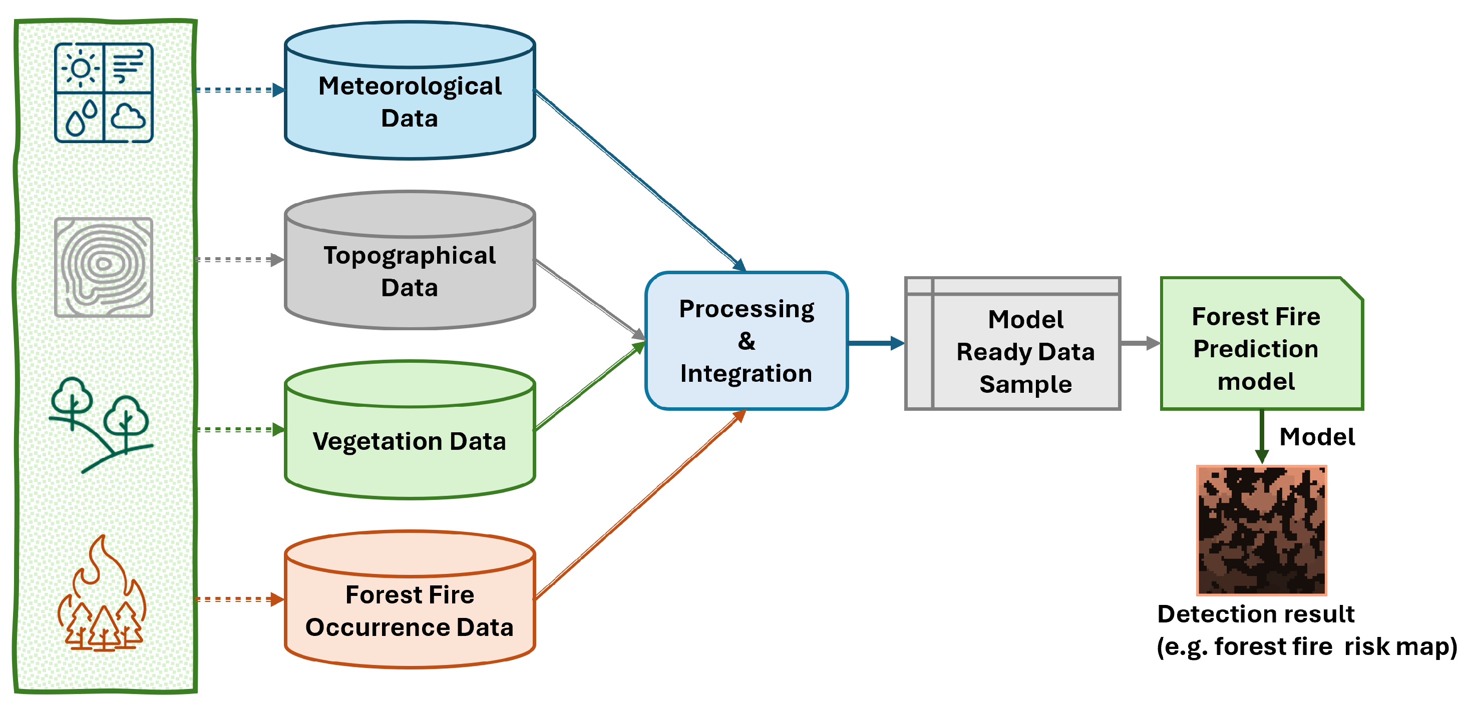
Figure 1 illustrates a high-level system model that leverages multi-modal data and supervised ML/DL algorithms to generate dynamic fire risk maps. Typical input features include meteorological conditions, topographical data, vegetation cover, and historical fire records—processed into model-ready formats for accurate detection [
17].
While ML and DL models can significantly enhance forest fire detection, the process of collecting raw data and creating a model-ready dataset is challenging [
18]. One of the first steps involves gathering comprehensive and high-quality data from various sources such as satellite imagery, weather stations, and historical fire records [
19]. These raw data often come in different formats and scales, necessitating extensive preprocessing to ensure consistency and usability.
Feature engineering is a critical phase where relevant features are extracted from raw data to improve model performance [
20]. This might include calculating vegetation indices from satellite images, deriving drought indices from weather data, or integrating topographical features. Proper processing of these features is often strengthened with domain knowledge to ensure they accurately reflect conditions that influence fire risk.
Another challenge is data balancing. Forest fire datasets often suffer from class imbalance, where the number of fire occurrences is significantly lower than non-fire instances. This imbalance can lead to models that are biased towards predicting the majority class. Techniques such as oversampling, undersampling, and synthetic data generation (e.g., Synthetic Minority Oversampling Technique (SMOTE) and Adaptive Synthetic Sampling (ADASYN)) are employed to address this issue and ensure the model learns to detect fires accurately [
21].
Model tuning, including selecting appropriate algorithms and optimizing hyperparameters, is essential to maximize the performance of ML and DL models [
22]. This process involves iterative experimentation and validation to find the best model selection. Techniques such as cross-validation, grid search, and Bayesian optimization are commonly used to systematically explore the hyperparameter space and improve model accuracy and robustness [
23].
Developing an effective machine learning model for forest fire detection requires a sequence of methodical and rigorously executed steps, including data acquisition, preprocessing, feature selection, class balancing, and hyperparameter optimization. The quality and integrity of input data at each stage are critical, as shortcomings in early phases can significantly degrade model performance. In this study, we present a comprehensive framework that includes an ablation study systematically evaluate the contribution of each component, highlighting the elements most critical to model robustness and predictive reliability. We validate our methodology using datasets from diverse regions, including Alberta [
24], British Columbia [
25], and Saskatchewan [
26], demonstrating its effectiveness in predicting fire risks under varying environmental conditions.
Objective:
The core objective of our work lies in proposing a lightweight, modular pipeline for forest fire risk modeling that is both reproducible and adaptable to various geographic regions, if the relevant input features are available. Instead of relying on computationally intensive deep learning approaches, our methodology focuses on efficient model development by systematically identifying the most effective preprocessing and modeling strategies. This includes selecting the best normalization technique for preparing the data, choosing the most suitable oversampling method to handle class imbalance, identifying optimal feature subsets and applying effective feature engineering techniques, and finally, selecting the most appropriate classifier based on comparative performance. The entire process is designed to be computationally efficient, making it particularly useful in regions with limited computing infrastructure. As such, our pipeline supports generalizability and can be readily applied to other regions globally where similar data types are available, offering a practical and scalable approach to forest fire risk prediction.
1.1. Major Contributions
The major contributions of this paper are as follows:
In contrast to traditional exhaustive model searches (which are typically computationally expensive and time consuming), we introduce a targeted evaluation strategy. This approach sequentially identifies and selects the optimal configuration of preprocessing, feature selection, oversampling, and modeling techniques, customized to the unique characteristics and requirements of individual datasets. By narrowing down model choices based on prior optimizations, this strategy significantly reduces computational overhead and development time. Despite these efficiencies, it maintains high model accuracy, making it ideal for real-time forest fire detection applications.
To validate the proposed methodology, we utilize three distinct and geographically varied datasets of three provinces in Canada, namely, Alberta, British Columbia, and Saskatchewan. Each dataset presents unique environmental conditions, providing a comprehensive evaluation of our approach’s robustness and adaptability. The validation demonstrates the ability of the proposed methodology to predict fire risks effectively across a range of conditions, ensuring its scalability and applicability to different regions.
We conduct an ablation study to assess the relative importance of each component in our methodology. By systematically removing or modifying individual elements, we identify the most influential features, preprocessing steps, and techniques that contribute to optimal model performance. This study ensures that the final model is optimum, highlighting the essential steps required to achieve robust forest fire detection.
1.2. Outline of the Paper
The rest of the paper is structured as follows:
Section 2 provides the background and discusses various classification algorithms, along with feature selection approaches and oversampling methods. In
Section 3, a review of related work on forest fire detection is presented.
Section 4 examines three datasets from different regions of Canada, focusing on the identification of key features and the development of the feature set for forest fire detection.
Section 5 introduces the proposed methodology, emphasizing the design of experiments to formulate our novel approach, as well as demonstrating its computational efficiency compared to exhaustive search methods.
Section 6 presents the model training and deployment.
Section 7 presents results and discussions where we analyze each dataset to identify optimal modeling parameters that enhance both model accuracy and computational efficiency.
Section 8 summarizes the key takeaways from our findings based on the results. Finally,
Section 9 provides the conclusions and future recommendations.
2. Background
The increasing frequency and intensity of wildfires driven by climate change and human activities have made early fire detection a critical priority. ML and DL models have emerged as powerful tools for detecting and predicting forest fires by analyzing complex environmental, meteorological, and spatial patterns [
8,
18]. Despite their promise, the effectiveness of these models is hindered by several methodological challenges: (1) selecting appropriate classification algorithms, (2) identifying the most relevant features, (3) addressing severe class imbalance between fire and non-fire instances, and (4) employing ablation techniques for rigorous model evaluation. In this section, we discuss the strengths and limitations of existing approaches across these four key areas.
2.1. Tree-Based Classification Models for Forest Fire Detection
Machine learning and deep learning algorithms can model complex relationships in environmental data that are often nonlinear and dynamic. Tree-based classifiers, such as Decision Trees (DT), Random Forests (RF), Gradient Boosting (GB), and Extreme Gradient Boosting (XGB), have proven particularly effective for forest fire prediction due to their interpretability, scalability, and robustness against noisy data [
27,
28,
29,
30]. These models are capable of learning from heterogeneous data that include temperature, humidity, wind speed, and vegetation indices. DTs provide a transparent structure that is easy to interpret, though they may suffer from overfitting. RF enhances generalization by training an ensemble of DTs on bootstrapped data and averaging their outputs, while Bagging further stabilizes performance through variance reduction [
29]. Boosting methods, including GB and Adaptive Boosting (AdaBoost), build sequential models that focus on hard-to-classify instances, making them highly effective in scenarios with class imbalance or noisy labels [
20,
30]. XGB further improves computational efficiency and generalization through regularization. The adoption of these algorithms in wildfire research reflects their ability to balance trade-offs between interpretability, computational cost, and detection accuracy. Moreover, these methods are well-suited for real-time or near-real-time prediction settings, where responsiveness and scalability are critical.
2.2. Feature Selection Strategies to Enhance Predictive Performance
With environmental datasets often containing dozens of correlated and redundant variables, feature selection (FS) is essential to improving model performance, reducing overfitting, and enhancing interpretability. Two widely adopted approaches are Model-Built Feature Importance (MBFI) and Recursive Feature Elimination (RFE) [
31]. MBFI techniques utilize the internal structure of tree-based models (e.g., RF, GB, XGB) to rank features based on their contribution to splitting decisions. These scores reflect how much each feature reduces node impurity (e.g., Gini index) or improves accuracy (e.g., Gain) during model training. This approach is computationally efficient and directly compatible with ensemble classifiers. RFE, in contrast, is a wrapper-based technique that starts with the full feature set and iteratively removes the least important features according to a trained classifier [
32]. When combined with tree-based models, RFE can provide highly accurate and compact feature subsets. RFE with RF leverages impurity reduction to guide feature elimination, while RFE with GB and XGB use loss reduction and regularization-adjusted Gain metrics to identify critical predictors [
33,
34,
35]. These techniques are especially useful in domains like fire detection, where input features such as temperature and humidity vary spatially and temporally and where the elimination of redundant features can significantly speed up model training and inference. Despite their advantages, RFE methods are computationally intensive and require repeated training of models, making them more suitable for offline optimization rather than deployment in real-time systems. Nevertheless, they remain valuable for identifying domain-specific features that improve model generalization.
2.3. Data Balancing Techniques to Address Class Imbalance in Fire Events
A critical challenge in wildfire detection is the inherent class imbalance in most datasets, as fire events are far less frequent than non-fire instances. This imbalance leads to biased models that may achieve high overall accuracy but perform poorly in detecting actual fire occurrences. Addressing this requires effective data balancing strategies that amplify minority class representation without introducing noise or overfitting. SMOTE and its variants are commonly used to tackle this problem. SMOTE generates synthetic minority (fire) instances by interpolating between existing minority examples and their nearest neighbors [
36]. This approach reduces overfitting associated with simple duplication and enhances the classifier’s exposure to minority class patterns. More advanced methods improve upon SMOTE by focusing on regions of the feature space where misclassifications are likely. Borderline SMOTE targets instances near class boundaries, generating new samples that help refine decision surfaces [
37]. Support Vector Machine–SMOTE (SVM-SMOTE) uses support vectors to identify critical minority instances and creates synthetic data in their vicinity, improving classifier sensitivity near complex boundaries [
38]. SMOTE with Edited Nearest Neighbor (SMOTE-ENN) integrates SMOTE with a postprocessing filter to remove noisy samples and preserve class boundaries [
39]. ADASYN further adapts the sampling density by focusing on harder-to-learn minority instances, enhancing the model’s ability to learn from underrepresented but informative data points [
40]. These balancing methods are essential in fire detection tasks where false negatives can have severe consequences. When used in conjunction with ensemble classifiers, they significantly improve recall and overall model fairness.
Ablation Techniques in Model Evaluation
In addition to balancing the data, ablation techniques can play a significant role in improving the performance of predictive models. Ablation involves systematically removing or altering specific components of the model to assess their impact on overall performance [
41]. This process helps researchers understand the role of various preprocessing, feature selection, and/or data balancing strategies in determining which model components are most critical for successful outcomes. By identifying the most influential elements, ablation methods contribute to the refinement and optimization of machine learning models. Research has shown that ablation studies can significantly enhance model accuracy by focusing on the most essential features and techniques for the task at hand [
42,
43,
44].
3. Related Work
Forest fire detection is a critical area for mitigating environmental damage and loss of life. Over the years, machine learning (ML) techniques have gained traction in this domain due to their ability to model complex, nonlinear interactions between fire-related factors. Initial methods relied on traditional statistical approaches such as logistic regression and Decision Trees, which lacked the capacity to capture the intricate dependencies among meteorological, topographical, and vegetation variables [
45]. More recently, advanced ML algorithms including neural networks, ensemble methods, and deep learning architectures have demonstrated improved predictive accuracy by leveraging richer datasets and more sophisticated model structures [
46,
47].
Despite these advances, several critical challenges hinder progress in forest fire detection. Firstly, the scarcity of comprehensive, publicly available benchmark datasets, particularly for Canadian forests, which constitute 9% of the global forest area [
48], severely limits model validation and cross-comparison [
49,
50]. While Kaur et al. [
24] compiled an 18-year dataset for Alberta and addressed class imbalance with Near-Miss3 undersampling, their work did not incorporate machine learning-based feature selection, leaving room for improvement in feature optimization. Expanding on this, Mutakabbir et al. [
51] created a nationwide Canadian dataset and introduced the novel STAS technique for imbalance handling, achieving promising results with deep learning models; however, issues remain regarding model robustness and feature diversity [
52]. In parallel, the emergence of Internet of Things (IoT) technology and federated learning offers new avenues for scalable, privacy-preserving fire detection frameworks. Purcell et al. [
25] pioneered a federated learning approach on IoT-collected British Columbia fire data, while Tavakoli et al. [
26] demonstrated performance gains using hybrid class balancing combining SMOTE and Near-Miss3. These approaches underscore the trend toward hybrid data processing techniques to address highly imbalanced datasets [
53,
54,
55].
Moreover, recent works have expanded the scope beyond binary fire occurrence detection to include dynamic risk mapping and real-time monitoring, using advanced convolutional neural networks [
47], multi-modal satellite imagery [
56], and topographical analysis [
57]. These innovations enhance situational awareness but still fall short in automated feature selection and standardized evaluation protocols, which are critical for generalizable and interpretable models. Model evaluation practices remain inconsistent, with a notable lack of standardized metrics and cross-validation across multiple datasets. The adoption of robust metrics such as Receiver Operating Characteristic—Area Under the Curve (ROC-AUC), alongside accuracy, precision, recall, F1-score, False Positive Rate (FPR), and False Negative Rate (FNR), has been advocated to provide comprehensive assessment [
58]. This is essential for fair comparison and understanding of trade-offs in imbalanced forest fire datasets.
In summary, several major research gaps remain unaddressed in the domain of forest fire detection. These include (i) the limited availability of benchmark datasets representing diverse Canadian forest regions, (ii) the underutilization of automated feature selection techniques such as Recursive Feature Elimination (RFE), (iii) the need for more effective data balancing strategies that assess both undersampling and oversampling methods, (iv) insufficient integration of multi-modal data sources for comprehensive modeling, (v) limited scalability and adaptability of existing models across different geographical regions, and (vi) a lack of standardized and rigorous evaluation for modeling.
Table 1 summarizes key recent studies, their contributions, and remaining gaps. Our study aims to address these gaps by proposing a comprehensive methodology that integrates automated feature selection, hybrid data balancing, and robust cross-validated evaluation, validated on multiple Canadian forest fire datasets: Alberta Forest Fire (AFF) [
59], British Columbia Forest Fire (BCFF) [
60], and Saskatchewan Forest Fire (SFF) [
61]. This approach seeks to enhance prediction accuracy, generalizability, and interpretability of forest fire detection models.
4. Datasets
In this study, we have used three distinct forest fire detection datasets from three provinces in Canada, namely, Alberta, British Columbia, and Saskatchewan. These datasets include various features essential for detecting forest fires, such as day, month, location, and fire history, which help in analyzing fire patterns across different regions.
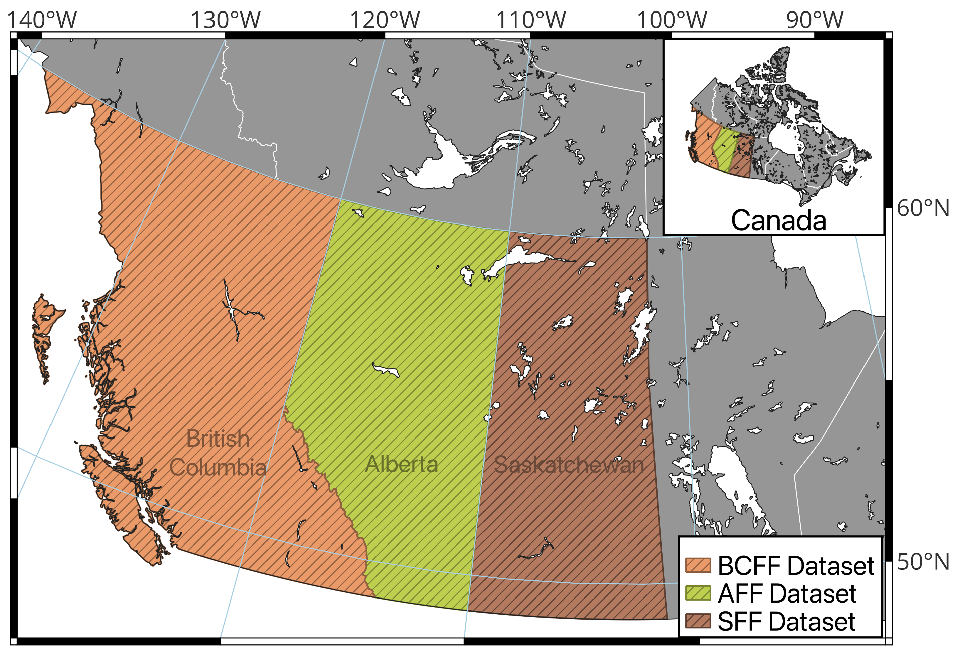
Figure 2 illustrates the map of the study areas.
Figure 3 provides an overview of the datasets, highlighting their key attributes and structure. Each dataset represents a specific region offering unique insights into the characteristics and dynamics of forest fires in these areas. For further details regarding the data sources of each dataset, please refer to the
Appendix A section, as shown in
Table A1.
The following subsections describe the development, features, and significance of each dataset in detail. Note that to evaluate the generalizability and robustness of the proposed approach, we used three publicly available wildfire datasets with varying feature sets and regional characteristics. This choice highlights that no single classifier, feature selection strategy, or oversampling method yields optimal results across all scenarios. The differences in dataset characteristics emphasize the need for adaptable models. A separate study aimed at harmonizing these datasets is currently underway.
4.1. Alberta Forest Fire (AFF) Dataset
Data collection and integration is a complex process due to the varying formats and resolutions of meteorological, biophysical, and topographical data. To address this, we standardized the data from multiple sources and integrated them into a unified dataset. The data focus on Alberta, Canada, covering an area of 661,848 km
2, of which 61% is forested. Analysis of data from Alberta.ca [
62] highlights the frequent occurrence of wildfires in the region each year. With a 10 km × 10 km spatial resolution, this dataset effectively covers fire ignition points. Higher resolutions (1 km × 1 km) result in a high-class imbalance, while lower resolutions (100 km × 100 km) may lead to multiple fire points in the same cell, causing imbalance. A daily resolution was chosen, and the dataset spanned 1 April to 31 October from 2000 to 2018, aligning with peak fire occurrences.
Three categories of data, namely meteorological, biophysical, and topographical data, were collected along with fire data for the Alberta forests.
Meteorological data from the Alberta Climate Information Service (ACIS) [
63] were gridded daily for Alberta townships. We used wind speed feature from this data source. Daily noon temperature records were obtained from ERA5-Land [
64] and also included in this dataset.
Normalized Difference Vegetation Index (NDVI) features were derived from historical Advanced Very-High-Resolution Radiometer (AVHRR) satellite images [
65]. The annual raster files contained latitude, longitude, and 26 NDVI bands for Julian weeks (15–41) from 6 April to 11 October. Using QGIS, the mean multiband zonal statistics generated the mean NDVI values for each grid cell.
Digital Elevation Models (DEMs) from Earth Explorer [
66] provided topographical features, using the Global Multi-resolution Terrain Elevation Data 2010 dataset [
67] (1 arc-second resolution, 2000–2020). Merging three DEMs in QGIS created Alberta’s DEM. Features such as slope and aspect were extracted and combined with elevation data by Grid ID.
Fire location data from Alberta wildfire records [
62], maintained since 1931, were used for the fire ignition labels in the dataset.
All data from these multiple sources were joined based on the grid ID and date to ensure same temporal and spatial resolution and the final dataset for Alberta forests was created in .CSV format.
Table 2 depicts the features and label of AFF dataset with a brief description for each feature.
4.2. British Columbia Forest Fire (BCFF) Dataset
The BCFF was constructed by combining two primary sources of information, namely, historical meteorological data and wildfire ignition records, each carefully restricted to locations within the official boundary of British Columbia. Meteorological data were obtained from ERA5-Land, a well-validated global reanalysis product. These data consist of temperature, humidity, wind direction, surface pressure, and precipitation measurements at a spatial resolution of 0.1° (approximately 11 km2) and were downloaded for the period 1980–2020. To mirror observed ignition patterns in BC, only the months May through September were retained, as fewer than 1% of ignitions occur from October through April. Although ERA5-Land offers hourly observations, only midday (12:00) samples were included in order to reduce data volume while aligning with conventions in fire weather modeling.
The historical wildfire ignition records were sourced from the BC Wildfire Services public data. This dataset spans multiple decades but was filtered to match the meteorological timeframe of 1980–2020. Entries typically contained geographic coordinates, ignition dates, and ignition causes (e.g., lightning or human-induced). In cases where precise times of ignition were missing (common in older records), the spatial and date information was still preserved. Additional cleaning steps included removing duplicate or incomplete records, such as those with missing coordinates or dates, and discarding any ignition points that fell outside BC’s boundaries.
After preparation, both datasets were standardized and merged. ERA5-Land files, initially in NetCDF format, were transformed into a tabular structure, creating rows keyed by date and geographic location. The ignition records were then joined to these rows, adding attributes for cause and binary ignition indicators, as well as any additional information (e.g., final burn area) when available. The result is a CSV-formatted dataset in which each record represents a specific day and location in BC. This record includes meteorological variables derived from ERA5-Land, along with an ignition label indicating whether a fire was initiated on that day and at that location.
Table 3 depicts the features and label of AFF with a brief description for each feature.
4.3. Saskatchewan Forest Fire (SFF) Dataset
The forest fire dataset for Saskatchewan was created by integrating multiple data sources to capture the diverse ecological features and fire dynamics of the region [
26]. Saskatchewan’s landscape, ranging from grasslands in the south to forests in the north, provides a unique opportunity to analyze fire behavior. The dataset was constructed using four main data sources: meteorological data from the Copernicus Climate Reanalysis (CCR) [
68], historical fire data from the Canadian Wildland Fire Information System (CWFIS) [
69], boundary files for the province, and water body data. The ERA5 climate data, covering the years 2000 to 2018, provided detailed time series of meteorological variables, such as temperature, humidity, and wind speed, which are essential for understanding the conditions leading to fire events. The fire data, sourced from CWFIS, offered precise fire locations, sizes, causes, and dates, critical for analyzing the spatial and temporal patterns of forest fires in Saskatchewan. The boundary files were used to clip the dataset to the province’s limits, ensuring that only relevant fire events within Saskatchewan were included, while water bodies were excluded to maintain the accuracy and relevance of the data for fire detection models [
61].
A comprehensive data-cleaning process was then applied, which involved removing instances where no fire events occurred and excluding any data points that fell within water bodies. This ensured that only meaningful data were retained, enhancing the dataset’s suitability for fire detection. The final dataset, spanning from 2000 to 2018, contains over 5.6 million rows of data, including both fire and non-fire events [
26]. Data collection and processing were conducted annually, with the ERA5 data retrieved 19 times once for each year in the range. The dataset, as detailed in
Table 4, incorporates a wide range of attributes, including meteorological variables, fire characteristics, and geographic information. By combining high-quality meteorological data from ERA5 with detailed fire data from CWFIS, this dataset provides valuable insights into fire behavior and serves as a foundation for fire risk detection models in Saskatchewan.
5. Proposed Methodology
To develop a robust and efficient forest fire detection model, we adopted a systematic approach incorporating normalization, feature selection, data balancing, and evaluation techniques such as ablation studies. This methodology ensures that each component of the model is optimized, leading to improved predictive performance.
We began with an undersampled yearly dataset, following the dataset creators’ to mitigate class imbalance by applying a 5:1 undersampling ratio across all datasets. To further refine the dataset, we applied various preprocessing techniques incrementally, namely (i) normalization, (ii) automated feature selection, and (iii) oversampling, before performing a 10-fold cross-validation (CV), as illustrated in
Figure 4. The normalization, feature selection, and oversampling for class balancing were implemented next.
We tested six different classifiers, namely, DT, RF, GB, XGB, and AB. These tree-based algorithms have been proven to be effective in predicting forest fire risks and addressing classification challenges in previous studies [
24,
60,
61]. By identifying the best-performing classifier in this step, we aimed for best feature selection, feature engineering and oversampling strategy for enhancing model performance. In the next step, two normalization techniques, Min–Max Scaling and Standard Scaling were used and their impact on the model performance were compared. The goal was to determine the optimal normalization method.
Next, automated feature selection method was chosen and CV runs were conducted by varying the number of top features from 1 to in increments of 1, using the best normalization technique identified. The optimal feature subset was then chosen ensuring that only the most relevant features contributed to model training. To further enhance the performance by class balancing, we compared five oversampling techniques, namely, SMOTE, SMOTE-ENN, Borderline SMOTE, SVM-SMOTE, and ADASYN, applied to the training dataset. By systematically comparing their impact, we identified the most effective oversampling method, which was subsequently incorporated into later stages. This step was crucial for addressing class imbalance, a common challenge in fire detection models.
In addition, an ablation study to assess the individual contributions of normalization, feature selection, and oversampling was performed. This analysis provided valuable information on the relative importance of each preprocessing step.
Throughout all CV runs, we evaluated performance using seven key metrics, namely, accuracy, F1 score, precision, recall, FPR, FNR, and AUC. The best model was selected based on AUC, with F1 score serving as the tiebreaker when needed. For all classifiers, we used default parameters.
The computational demand in hyper-tuning and deep learning models may hinder the adaptation of data-driven AI-based solutions for forest fire risk prediction. A practical methodology and deployment strategy can encourage practitioners to use these methods. While an exhaustive search with classifiers, normalization methods, feature selection methods, features and oversampling methods requires cross-validation runs, using our proposed approach, we select the optimum model from CV runs.
Note that while lightning is a major natural cause of wildfires, lightning forecast data were not incorporated in this study due to their limited availability and inconsistent real-time accessibility across the regions of interest. However, our proposed methodology and framework are designed to be extensible and can incorporate such data when reliable sources become available. Regarding human-related ignitions, although direct modeling of human activity is beyond the scope of this work, the improved spatial and temporal risk mapping provided by our approach can help wildfire management agencies better target prevention and rapid response efforts, thereby potentially mitigating human-caused fire incidents.
6. Model Training and Deployment
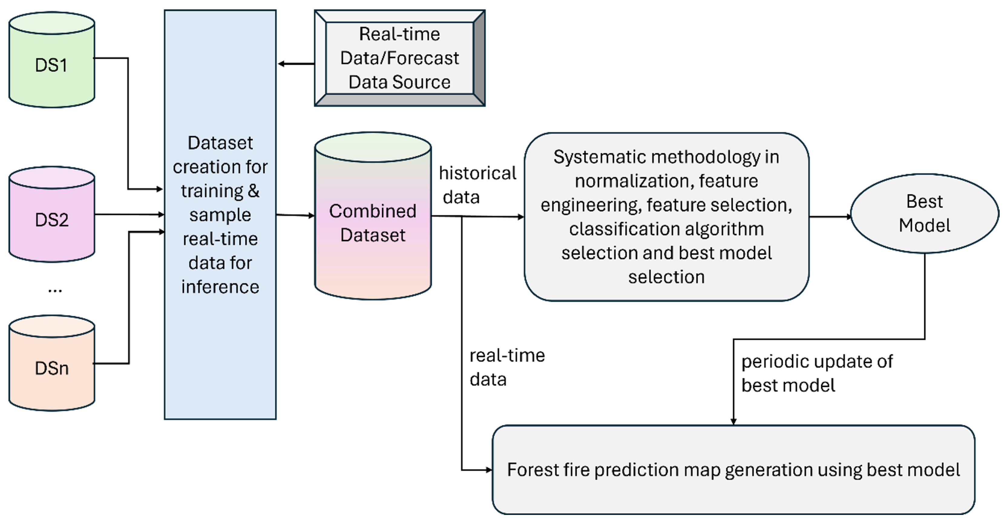
The offline training and real-time inference pipeline using our proposed methodology is illustrated in
Figure 5. Periodic offline training and best model selection ensure that the system remains adaptive to new data, with the possibility of incorporating incremental training. During real-time inference, the fire risk of a region can be assessed using the output of the trained prediction model. To support early warning systems, our model is designed for real-time deployment and can be integrated with IoT infrastructures such as smoke and heat sensors, optical/thermal imaging, and satellite feeds. Once trained, the model can run on edge devices or cloud platforms to process streaming data, enabling fast and scalable fire risk inference. This integration helps reduce detection latency by providing predictive insights ahead of physical confirmation from sensors, thus enhancing situational awareness and response readiness.
While lightning is a major natural cause of wildfires, lightning forecast data were not incorporated in this study due to their limited availability and inconsistent real-time accessibility across the regions of interest. However, our proposed methodology and framework are designed to be extensible and can incorporate such data when reliable sources become available. Regarding human-related ignitions, although direct modeling of human activity is beyond the scope of this work, the improved spatial and temporal risk mapping provided by our approach can help wildfire management agencies better target prevention and rapid response efforts, thereby potentially mitigating human-caused fire incidents.
To evaluate the generalizability and robustness of the proposed approach, we used three publicly available wildfire datasets with varying feature sets and regional characteristics. This choice highlights that a single classifier, feature selection strategy, or an oversampling method may not yield optimal results across all scenarios. The differences in dataset characteristics emphasize the need for adaptable methodology and models. A separate study focused on harmonizing these datasets is currently underway.
7. Results and Discussions
In this section, we apply our proposed methodology to three forest fire datasets, namely, AFF, BCFF, and SFF. We use data from the year 2014 for each dataset, as 2014 ranked among the top five worst wildfire seasons in Canada in terms of total area burned. This selection provides a relevant test case for evaluating forest fire detection models. We demonstrate how ML-based detection performance can be improved by following our proposed methodology. The experimental results and corresponding discussions are provided for each dataset.
7.1. Alberta Forest Fire Detection
Table 5 shows baseline CV run results using AFF dataset for six classifiers. The RF model performs the best with an F-Score value of 80.23% and AUC of 86.38%. However, as expected, because of the imbalance (majority vs. minority ratio = 5:1), the FNR value is quite high (24.78%). Next, we applied different normalization techniques to see whether and what type of normalization may be effective for this dataset. Min–Max normalization achieves a slightly better result than Standard Scalar and baseline (no normalization). For subsequent experiments, we used Min–Max normalization.
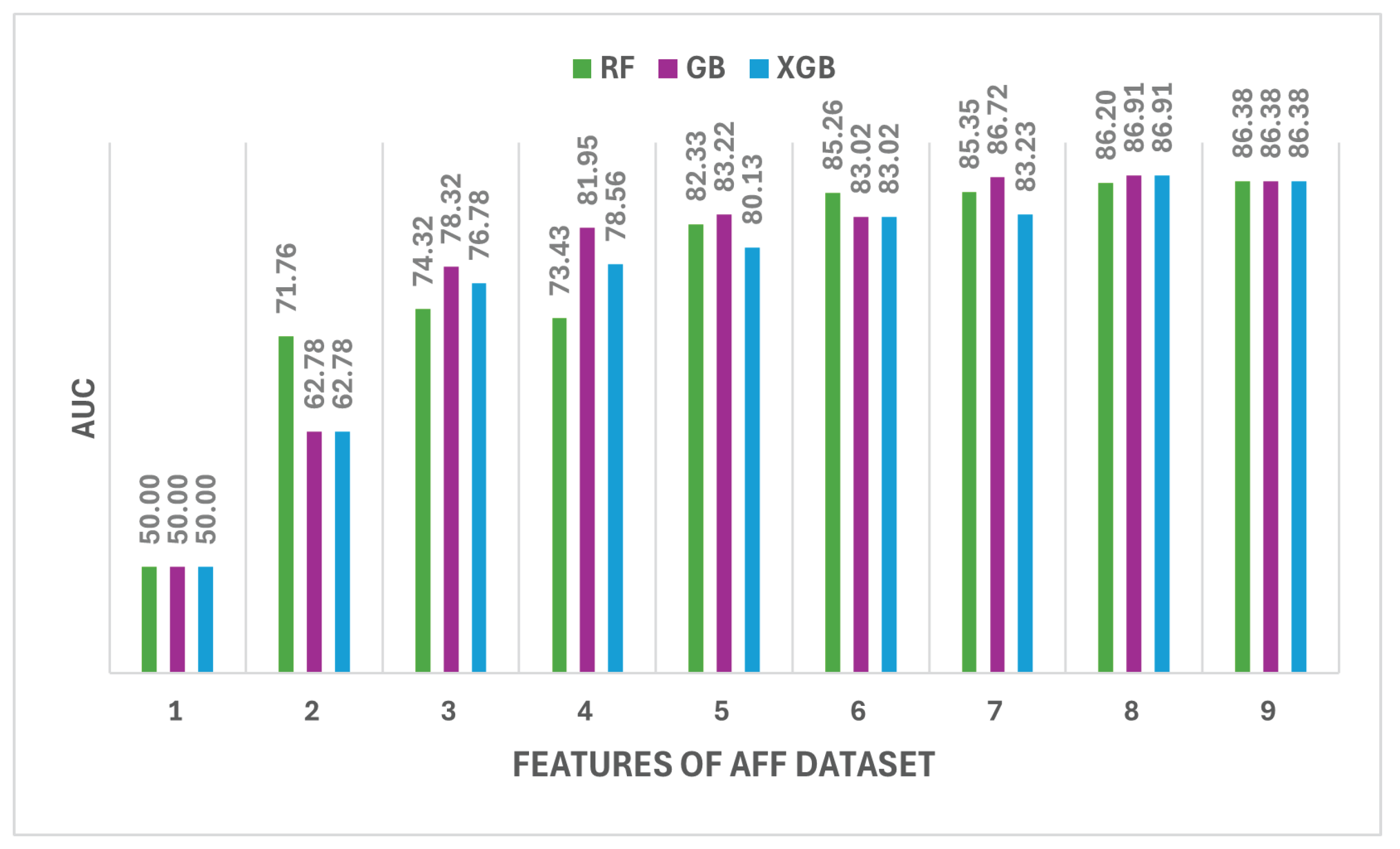
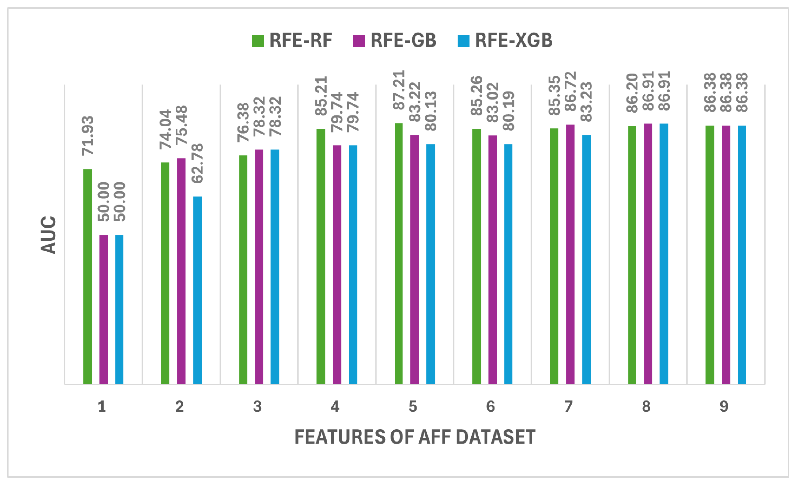
We used six automated feature-ranking techniques and experimented with top N features where N varied from 1 to 9 with a step of 1. Two categories of feature selection methods were used: (i) Model-Based Feature Importance (MBFI) and (ii) Recursive Feature Elimination on Model-Based Feature Importance (RFE). The models used were RF, GB, and XGB. In the second category, it used the model’s built-in feature importance score, as well as Recursive Feature Elimination on top of that, i.e., RFE-RF, RFE-GB, and RFE-XGB. The results for both categories of feature are shown in
Figure 6 and
Figure 7.
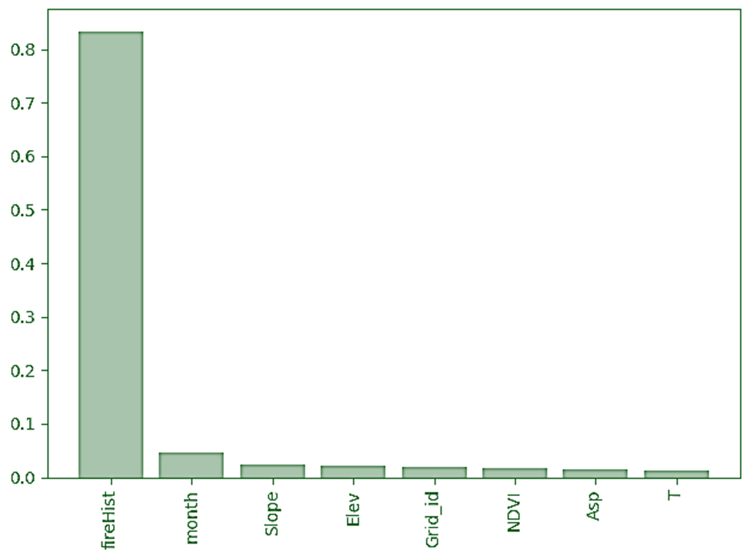
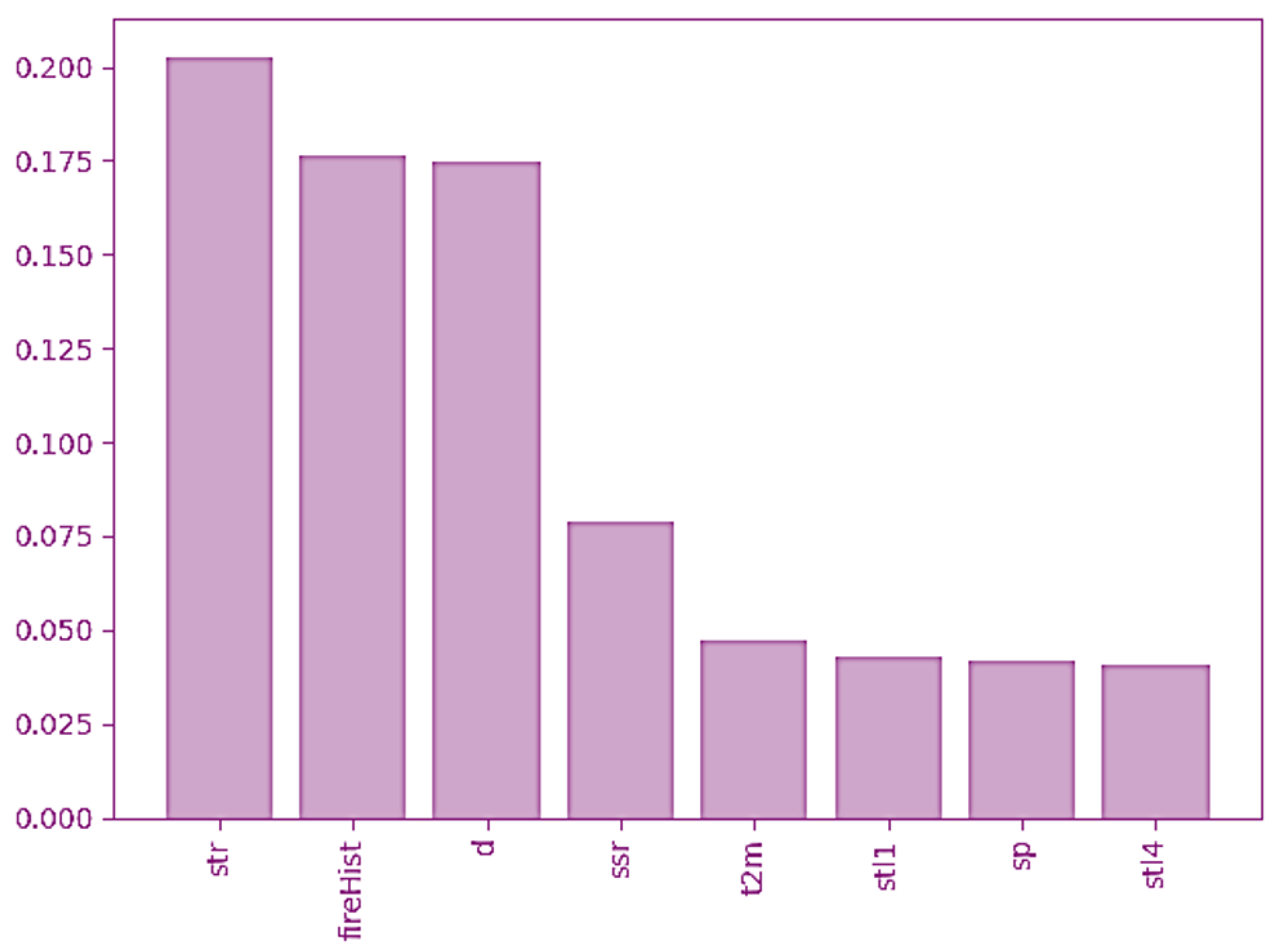
GB and XGB feature selections provided the best result when the number of top features was 8. The only feature that was deemed not effective is wind speed. This finding can be intuitively explained as wind speed is a useful factor for forest fire growth modeling but has no or little impact on fire ignition. Although the difference in the result is not significant, we used the top 8 features for our subsequent experiments, i.e., eliminating wind speed from the input feature list. The top 8 selected features are shown in
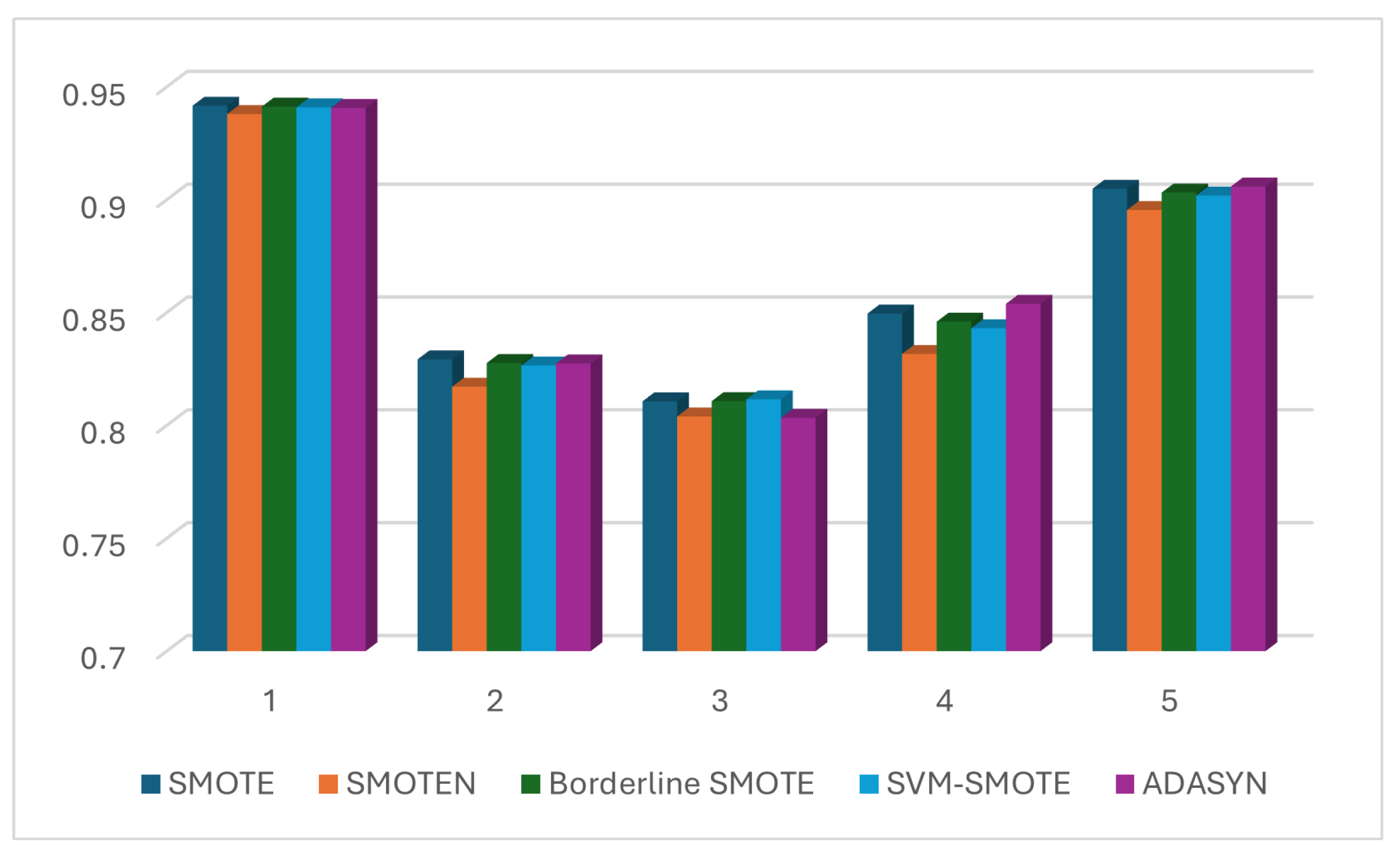
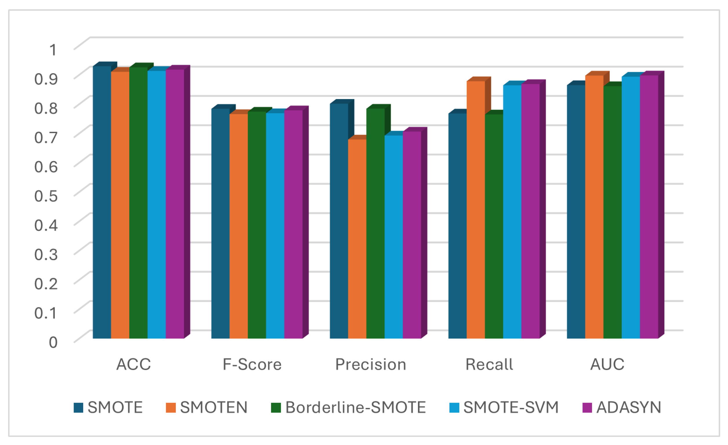
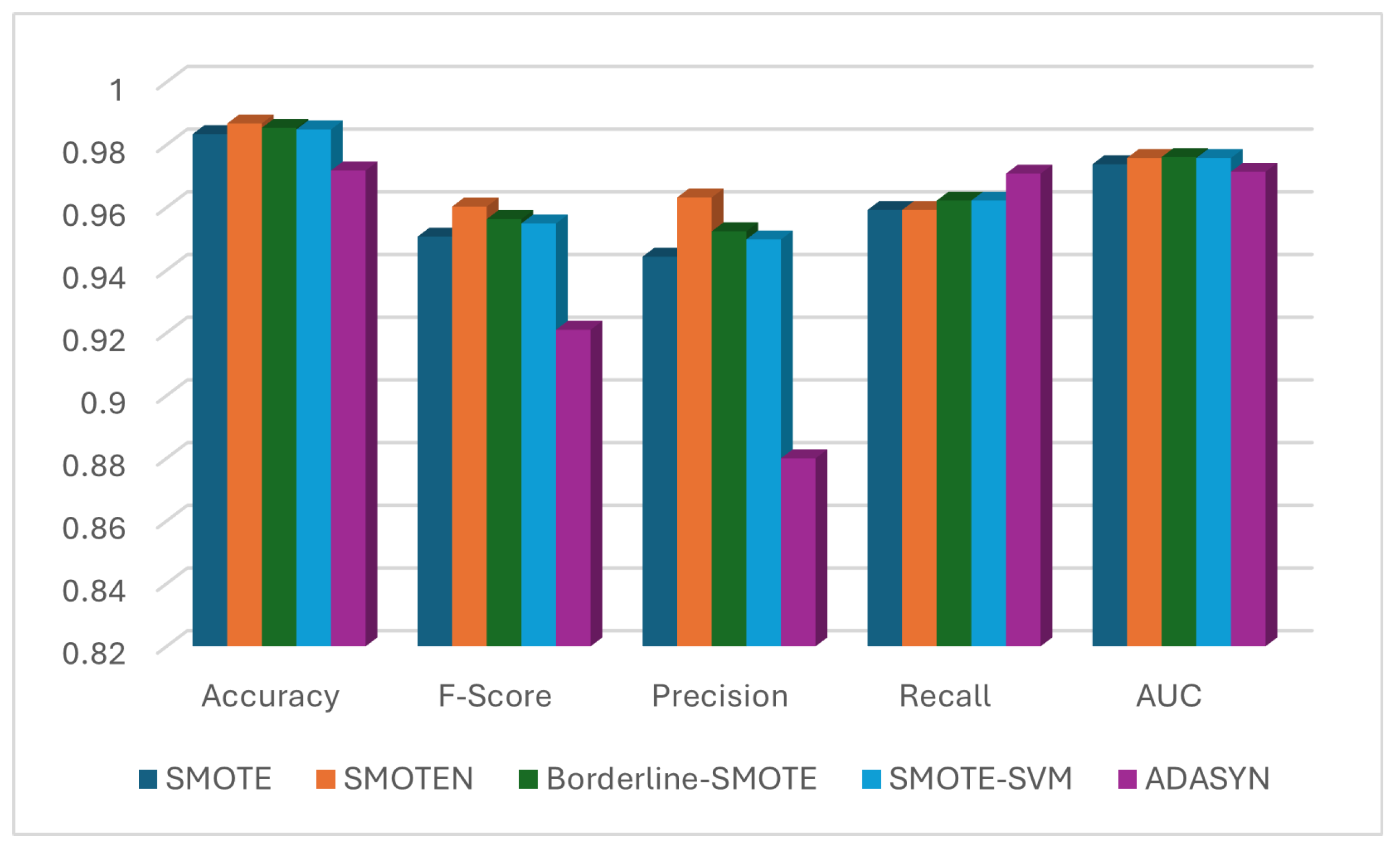
Figure 8 in descending order of the importance score of the feature. Similar results were obtained with the category 2 feature selection algorithms. For simplicity and speed, we considered XGB as our feature selection technique for further experiments. Next, we used five different synthetic data generation techniques also known as oversampling, for minimizing further the imbalance of the classes. The methods we used are SMOTE, SMOTEN, Borderline SMOTE, SVM-SMOTE, and ADASYN. A comparison of these methods is shown in
Figure 9. The AUC value is increased to the maximum of 90.59% with ADASYN oversampling. As expected, the FNR was improved from baseline value of 24.78% to only 14.6%—about 41% reduction.
The ablation study results using the AFF dataset are shown in
Table 6. It is interesting to note that the ablation of normalization had more negative impact on model performance than that of feature selection. This dataset contains features that are well-thought-out and therefore, there is not much scope of improvement using automated feature selection techniques; however, the proposed methodology would be effective for modeling activities with other datasets.
7.2. British Columbia Forest Fire Detection
Table 7 shows the cross-validation results of six classifiers with BCFF dataset. The Extreme Gradient Boost (XGB) model performed the best with an F-Score value of 77.52% and AUC of 86.18%. However, as expected, the FNR value was quite high (23.44%). Interestingly, the normalization did not have any impact on the performance of the model in this case. This requires further investigation to see how XGB works internally. For subsequent experiments, we used Min–Max normalization.
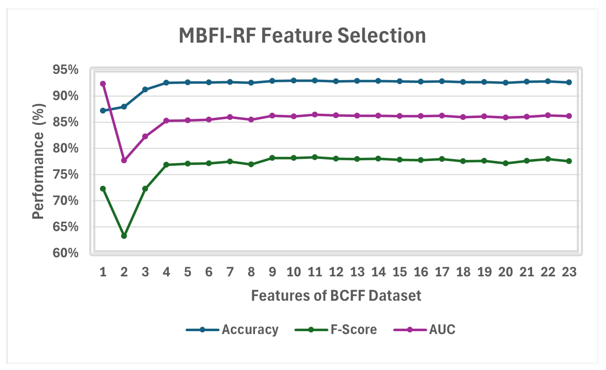
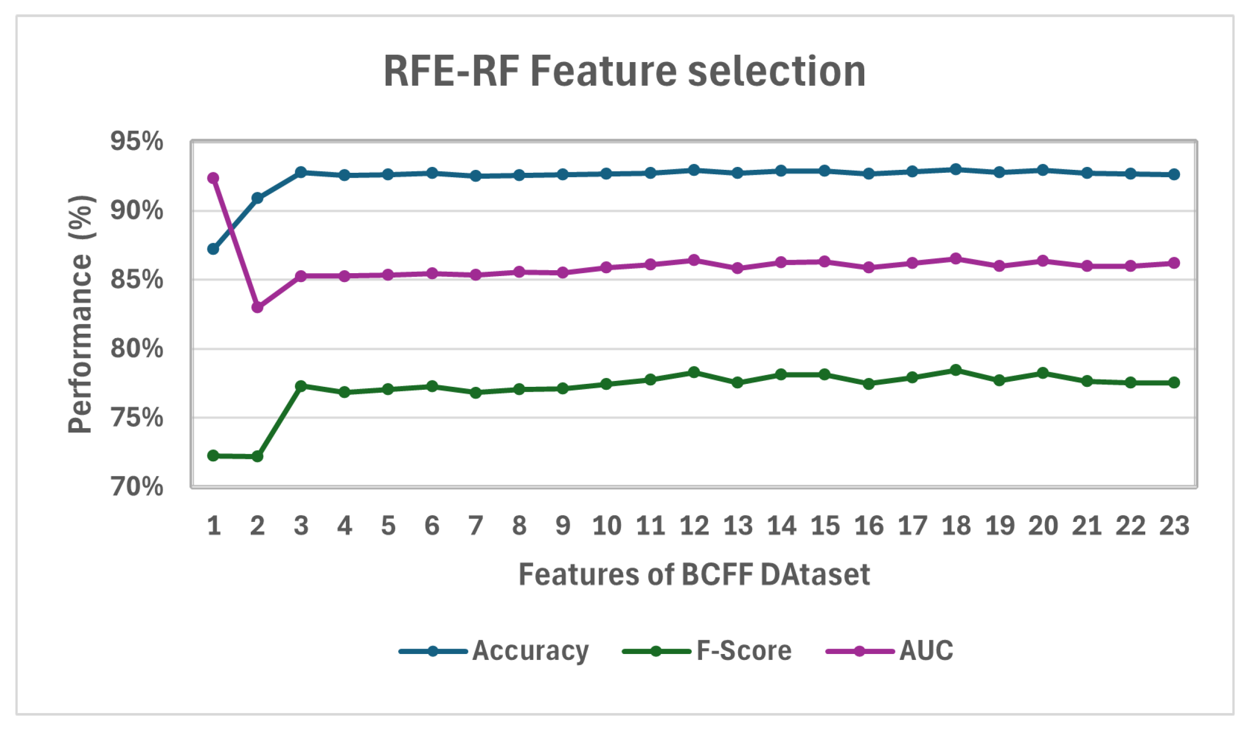
Next, we compared six automated feature-ranking techniques with top N features where N was varied from 1 to 18 with a step of 1. The results for the best feature selection method from both categories (without and with RFE) of feature selection are shown in
Figure 10 and
Figure 11. With only 18 features out of the total 23 features, RF feature selection provided the second-best result, with a ROC-AUC score of 86.50. We discarded the best result of 92.32% where fire history was the only feature since this was an exceptional case. In addition, considering only this feature will prevent us from detecting fire where fire may not have happened in the past. RFE-XGB also exhibited similar results with only 18 features. We considered RF as our feature selection technique for the rest of the experiments with this dataset. The top 18 features with BCFF using the RF feature selection method are shown in
Figure 12.
The comparison of five oversampling techniques for minimizing further the imbalance of the classes and enhancing the model performance using BCFF dataset is shown in
Figure 13. The AUC value increased to a maximum of 89.82% with SVM-SMOTE oversampling. As expected, the FNR improved from a baseline value of 23.18% to only 13.12%—about 43% reduction. Borderline SMOTE and ADASYN also came close with ROC-AUC values of 89.39% and 89.68%, respectively.
The ablation study result using the BCFF dataset is shown in
Table 8. The most impact occurred when the fire history feature was excluded, which was the result of feature engineering. This quick ablation study using British Columbia Forest data further validates our systematic methodology to improve model performance. Normalization has no impact and feature selection in this dataset is much less important than feature engineering and oversampling.
7.3. Saskatchewan Forest Fire Detection
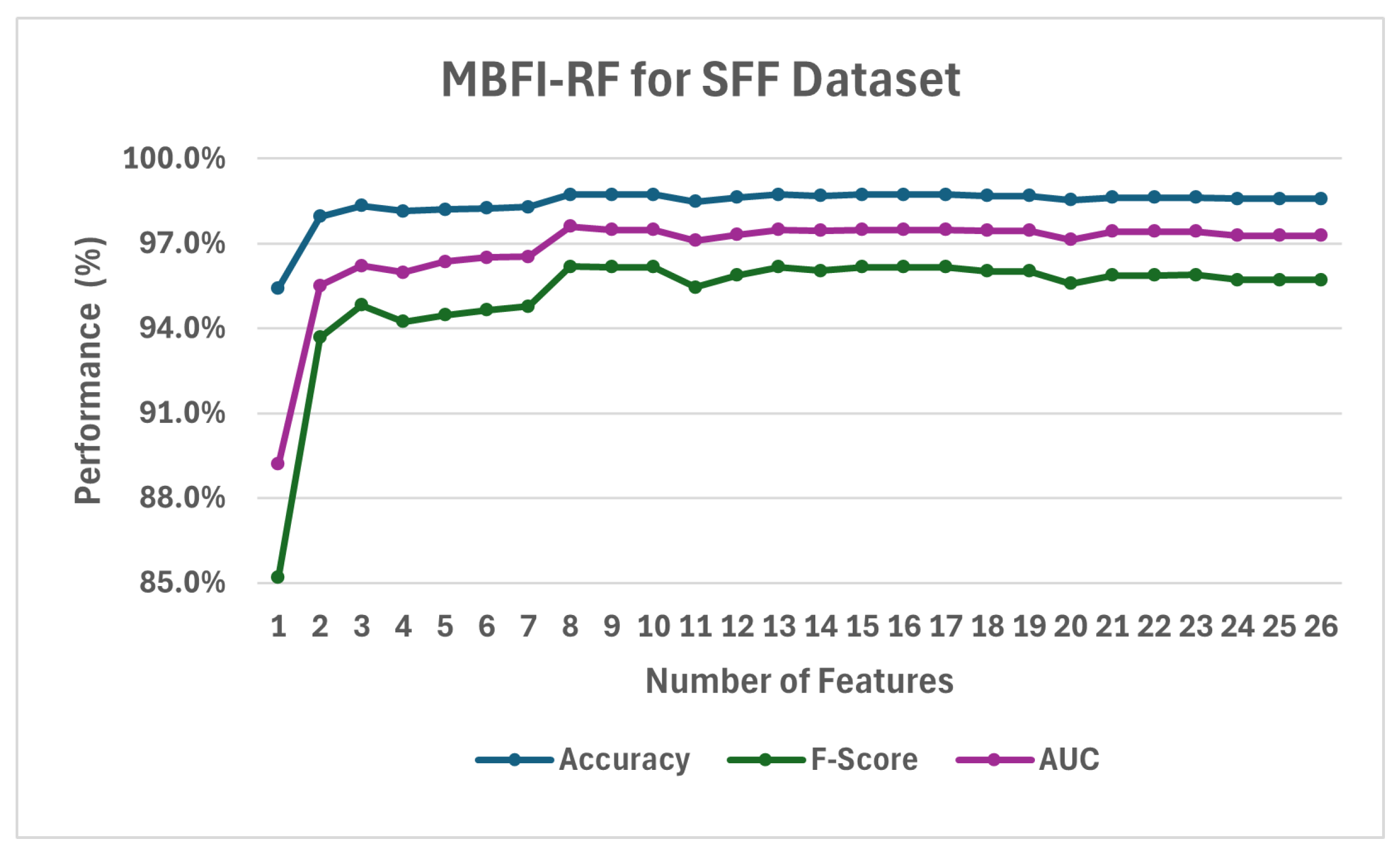
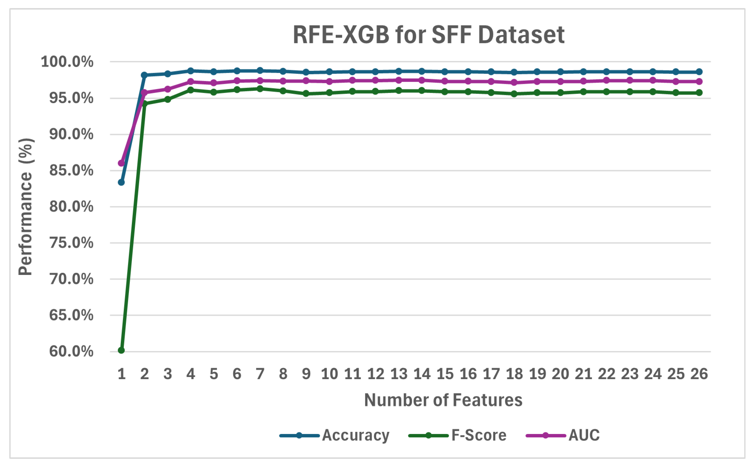
Table 9 shows the baseline CV run results using six classifiers and SFF dataset. The Gradient Boost (GB) model performs the best with an F-Score value of 96.01% and AUC of 97.46%. Interestingly, even with the imbalance (majority vs. minority ratio = 5:1), the FNR value is not as high as found in the other two datasets (4.38%); leaving us not much room for improvement. Next, we applied different normalization techniques to see whether and what type of normalization may be effective for this dataset. Interestingly, both normalization techniques, i.e., Min–Max and Standard Scalar, provided the same results and the dataset without normalization provided better results. For subsequent experiments, we used no normalization.
Next, we used six automated feature-ranking techniques and experimented with top N features where N varied from 1 to 26 with a step of 1. Sample results for the best feature selection methods from both categories (MBFI and RFE) are shown in
Figure 14 and
Figure 15.
MBFI-RF feature selection provided the best result with an ROC-AUC score of 97.61%, as shown in
Figure 14. RFE-XGB from the second category shows significantly less accurate performance (an ROC-AUC score of 97.46%) with 13 features. We used RF with eight features for the rest of the experiments.
Figure 16 depicts the feature importance scores for the top eight features.
The oversampling techniques for class balancing were applied next. The comparison results are presented in
Figure 17. When comparing the results of oversampling with a model without oversampling, based on ROC-AUC and F1-Score, none of the oversampling methods worked well. However, Borderline SMOTE achieved the same ROC-AUC score of 97.61%, with a slightly lower F1-score, but approximately, a one percent reduction in FNR than those of the model without oversampling.
Next, we assessed the individual impact of normalization, feature selection, feature engineering, and oversampling by removing one technique at a time while keeping the remaining techniques unchanged. The results are shown in
Table 10. The oversampling method had little impact on the performance of the model. However, like in the previous two datasets, the most impact was observed when excluding the fire history feature from the SFF dataset.
To validate the stability and robustness of our proposed model selection pipeline, we performed 10-fold cross-validation and reported average performance metrics including accuracy, precision, recall, F1-score, AUC, FPR, and FNR. We also calculated the standard deviation of these metrics across different folds for the best model configurations for the three datasets. The relatively low standard deviation values across the 10 folds as shown in
Table 11, particularly with most metrics below 0.04, indicate that the model’s performance is stable and consistent across different subsets of the data. This suggests robustness and generalizability, demonstrating that the model’s behavior is not overly sensitive to specific data characteristics and a yearly update of the model might be sufficient to maintain strong performance.
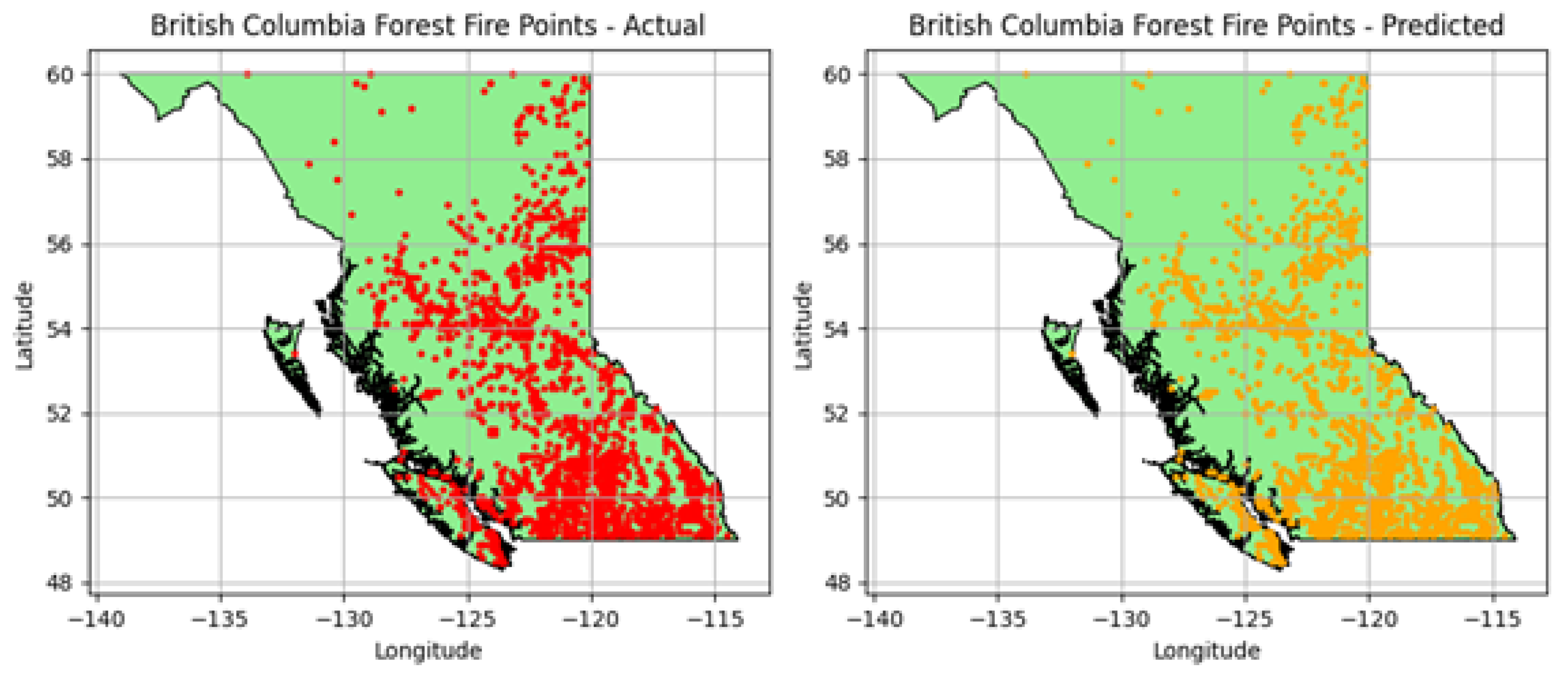
In addition, to complement the quantitative evaluation metrics, we provide spatial visualizations of actual and predicted forest fire occurrences in
Figure 18. The side-by-side maps illustrate the geographic distribution of ground-truth fire events alongside the locations identified by our prediction model. This spatial comparison highlights the model’s ability to accurately detect fires across diverse regions, reinforcing the robustness and practical applicability of the methodology. Such visual outputs are crucial for real-time wildfire management systems, enabling responders and decision-makers to quickly assess and act upon model predictions in specific geographic contexts.
Finally,
Table 12 compares our model results with some of the recent work. Models developed using our proposed methodology outperform similar tree-based ensemble models and deep learning models in most cases. The computationally expensive Deep learning Neural Network (DNN) model trained on Canada-wide dataset [
70] used up to 560 historical features (40 raw features for previous 14 days) to achieve accurate prediction.
Our proposed methodology was validated on three diverse datasets, each representing different geographic and ecological conditions. This comparative evaluation provides preliminary evidence of the ability to generalize the methodology for model building across regions. Furthermore, the feature engineering and model design are modular and adaptable, enabling the integration of seasonal variables and data from different resolutions, including near real-time satellite streams or image data, without significant re-engineering. Future work will involve retraining and testing the model using fine-resolution imagery and time-sensitive data from other countries to further validate cross-regional and cross-season applicability.
8. Summary and Key Takeaways
In this section, we summarize the key observations and findings based on the performance of our proposed approach, comparing it to the baseline methods. Additionally, we highlight the importance of computational efficiency in the context of forest fire detection, where both high accuracy and quick processing are critical for continuous best model selection and real-time detection.
8.1. Observations of Proposed Approach Compared to Baseline
Table 13 summarizes the results of applying our proposed approach on three datasets, namely, AFF, BCFF, and SFF, where the normalization, feature selection, oversampling techniques, and modeling strategies are optimized for each dataset. Our key findings highlight the importance of tailored preprocessing, efficient feature selection, and appropriate model choice in optimizing performance across different datasets.
Observation 1: We observed that the effectiveness of normalization techniques varied depending on the dataset. Min–Max normalization yielded the best results for the AFF dataset, while the BCFF dataset demonstrated flexibility with any normalization technique. In contrast, the SFF dataset did not require any normalization, emphasizing the need to select preprocessing methods based on the characteristics of the dataset. This approach ensures optimal data transformation and model performance.
Observation 2: By evaluating MBFI and RFE methods for feature selection, we significantly reduced the feature space without compromising model accuracy. In the AFF dataset, the feature count decreased from 9 to 8, while BCFF saw a reduction from 23 to 18, and SFF reduced from 26 to 8 features. This dimensionality reduction not only enhanced model interpretability but also improved computational efficiency, demonstrating the value of efficient feature selection in model optimization.
Observation 3: Our use of oversampling techniques, such as ADASYN for the AFF dataset and SMOTE for the BCFF dataset, resulted in notable performance improvements, particularly for addressing class imbalance. However, we found that no oversampling was needed for the SFF dataset, indicating that the effectiveness of these techniques is highly dataset-dependent.
Observation 4: The choice of model played a crucial role in maximizing performance. For the AFF dataset, we found that RF outperformed other models, while XGB provided the best results for BCFF, and GB was most effective for the SFF dataset. This underscores the necessity of model flexibility, as different models are better suited to specific dataset characteristics, particularly in the context of forest fire detection.
8.2. Baseline vs. Proposed Approach: Performance Comparison
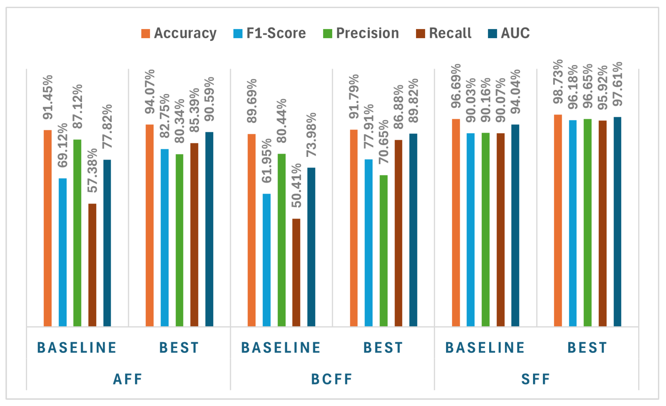
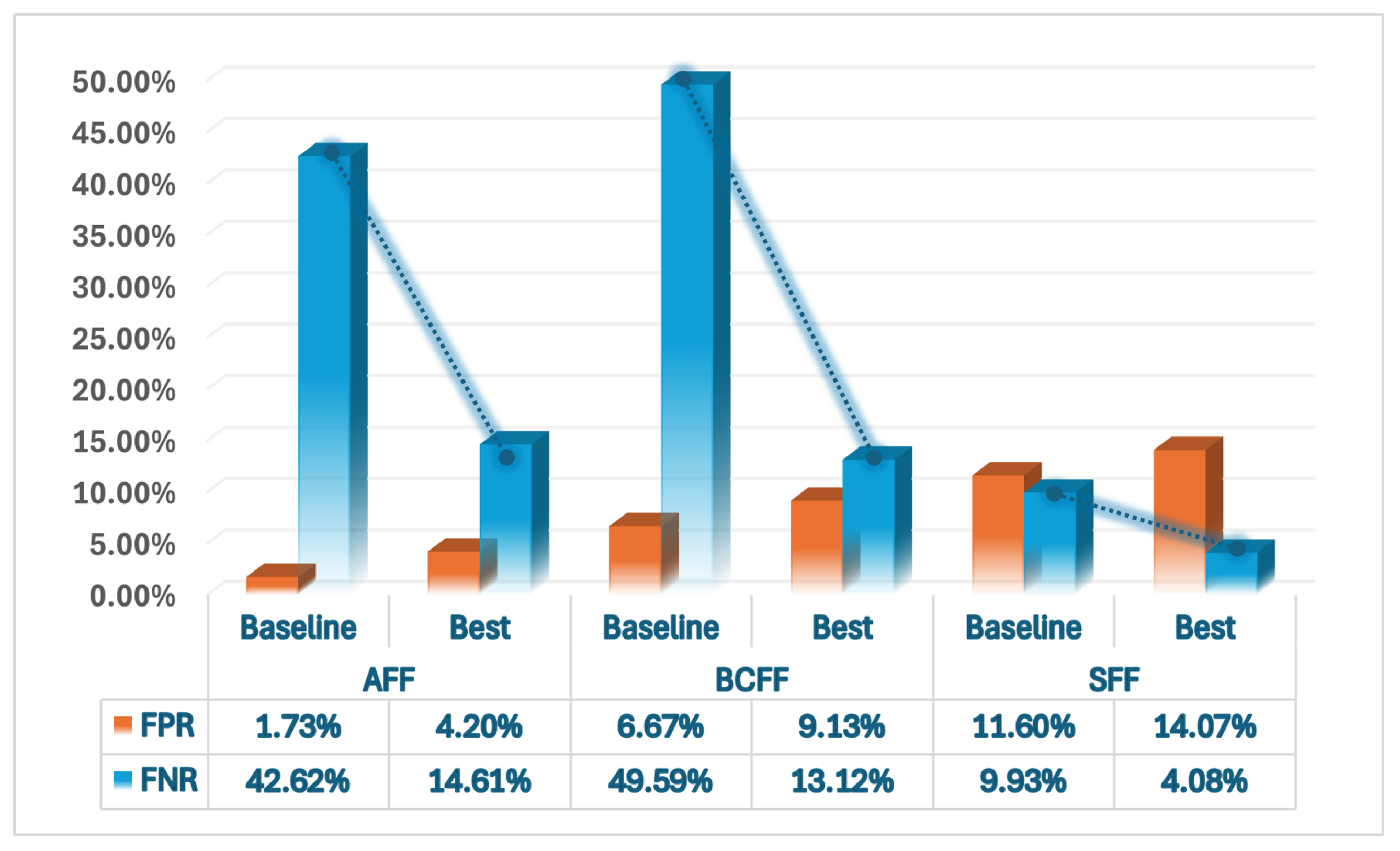
In addition, we compare the best performing model from our proposed approach with the baseline model between three datasets in terms of several evaluation metrics. The results are illustrated in two graphs, specifically in
Figure 19 and
Figure 20.
Figure 19 visualizes key performance metrics, including accuracy, F1 score, precision, recall, and AUC for both the baseline model and the best performing model on the AFF, BCFF, and SFF datasets. From the graph, it is evident that our proposed approach consistently outperforms the baseline in all key metrics across all datasets. Specifically, the best model delivers significant improvements in F1-score and recall, essential for detecting true fire events, while also maintaining a high AUC, indicating robust model performance across various decision thresholds. For the AFF model, we observed that the precision increased from 91.45% to 94.07%, the F1 score improved from 69.12% to 82.75%, and the recall increased from 57.38% to 85.39%, with AUC increasing from 77.82% to 90.59%. The BCFF model showed an increase in precision from 89.69% to 91.79%, the F1 score from 61.95% to 77.91%, and recall from 50.41% to 86.88%, with the AUC increasing from 73.98% to 89.82%. The SFF model demonstrated the most significant improvements, with accuracy rising from 96.69% to 98.73%, F1-score from 90.03% to 96.18%, and recall from 90.07% to 95.92%, with AUC improving from 94.04% to 97.61%.
In terms of FPR and FNR,
Figure 20 compares the baseline model and the best model identified by our proposed approach. For the AFF model, FPR increased from 1.73% in the baseline to 4.20% in the best model, while FNR decreased from 42.62% to 14.61%, showing a reduction in false negatives. The BCFF model showed a similar trend, with FPR rising from 2.45% to 7.23%, but FNR decreased from 49.59% to 13.12%. The SFF model showed a significant improvement, with FPR dropping from 1.99% in the baseline to 0.70% in the best model, and FNR decreasing from 9.93% to 4.08%.
8.3. Key Takeways
Key Takeaway 1: Our proposed approach consistently outperforms the baseline across all key metrics, namely, accuracy, F1-score, precision, recall, and AUC on all datasets. The significant improvements in F1-score and recall, crucial for detecting true fire events, demonstrate the model’s ability to maintain high performance while enhancing the reliability and effectiveness of fire detection across various datasets.
Key Takeaway 2: The significant reduction in FNR underscores the effectiveness of our proposed approach, enhancing model performance and ensuring more reliable and accurate fire event detection by minimizing false negatives.
Key Takeaway 3: Our approach achieves a 97.75% reduction in computational cost, enabling more frequent and efficient model training, evaluation, and real-time forest fire detection in resource-constrained devices. This substantial decrease in complexity ensures both scalability and responsiveness, making the system a viable solution for large-scale monitoring and early intervention.
9. Conclusions and Future Work
This research presents an optimized framework for ML-based forest fire model training and detection, balancing predictive accuracy with computational efficiency for real-time deployment in monitoring systems. Through a comprehensive evaluation of preprocessing, feature selection, and model strategies, we demonstrate that dataset-specific optimizations significantly enhance performance while reducing computational overhead. Our findings highlight the importance of tailored preprocessing techniques, with AFF performing best under Min–Max normalization, BCFF showing robustness across methods, and SFF requiring no normalization. The use of MBFI and RFE for feature selection reduced dimensionality while maintaining classification performance, improving both interpretability and efficiency.
The proposed approach significantly improved key performance metrics, notably F1-score, recall, and AUC, while maintaining high accuracy across all datasets. The F1-score saw considerable improvements, with AFF rising from 69.12% to 82.75%, BCFF from 61.95% to 77.91%, and SFF from 90.03% to 96.18%. Notably, the reduction in FPR and FNR across all three datasets highlights the effectiveness of our method. For example, FPR for AFF increased slightly from 1.73% to 4.20%, but FNR dropped drastically from 42.62% to 14.61%, showing a significant reduction in false negatives. Similarly, FNR for BCFF and SFF also showed major reductions, confirming the enhanced precision and reliability of our approach in detecting true fire events.
Additionally, adaptive oversampling techniques, such as ADASYN for AFF and SMOTE for BCFF, improved class balance and model performance, whereas SFF needed no oversampling. Dataset-dependent model selection led to optimal results, with RF for AFF, XGB for BCFF, and GB for SFF. Notably, our optimized evaluation strategy reduced computational cost by 97.75% ensuring real-time detection even on resource-constrained devices such as remote sensors and edge computing units.
The contributions of this study offer a scalable framework for large-scale forest fire monitoring. Future research could incorporate real-time adaptive learning mechanisms and integrate multi-modal data sources, such as satellite imagery and IoT-based sensors, as well as homogeneous datasets (the same set of features) for all provinces of Canada to improve early warning and detection capabilities. These advancements would strengthen global wildfire prevention and mitigation efforts, promoting more resilient disaster management systems.
Author Contributions
Conceptualization, M.Z., D.U., S.S., C.-H.L., and K.N.; methodology, M.Z.; Software, M.Z.; validation, M.Z., D.U., A.M., C.-H.L., K.N., R.P., and S.S.; formal analysis, M.Z. and D.U.; investigation, M.Z., C.-H.L., K.N., and S.S.; resources, M.Z., A.M., and R.P.; data curation, M.Z. and R.P.; writing—original draft preparation, M.Z. and D.U.; writing—review and editing, M.Z., A.M., C.-H.L., K.N., R.P., S.S., and D.U.; visualization, M.Z., D.U., and A.M.; supervision, C.-H.L., S.S., K.N., and M.Z.; project administration, S.S., C.-H.L., and K.N.; funding acquisition, C.-H.L., K.N., M.Z., and S.S. All authors have read and agreed to the published version of the manuscript.
Funding
The research was partly funded by an Alliance Missions grant from the Natural Sciences and Engineering Research Council (NSERC) of Canada.
Institutional Review Board Statement
Not applicable.
Informed Consent Statement
Not applicable.
Data Availability Statement
The authors confirm that the processed data supporting the findings of this study are available from the corresponding author upon reasonable request.
Acknowledgments
The research produced is part of ongoing collaborative work between Carleton University, University of Waterloo, and Dalhousie University with industry partners Cistel Technology.
Conflicts of Interest
Author Marzia Zaman was employed by the company Hegyi Geomatics. Author Darshana Upadhyay was employed by the company Sanstream Technology. The remaining authors declare that the research was conducted in the absence of any commercial or financial relationships that could be construed as a potential conflict of interest.
Abbreviations
The following abbreviations are used in this manuscript:
| AB | Adaptive Boosting |
| ADASYN | Adaptive Synthetic Sampling |
| AFF | Alberta Forest Fire Dataset |
| ANN | Artificial Neural Network |
| BAG | Bagging |
| BCFF | British Columbia Forest Fire Dataset |
| Borderline SMOTE | Borderline Synthetic Minority Oversampling Technique |
| DT | Decision Tree |
| FNR | False Negative Rate |
| FOP | Fire Occurrence Prediction |
| FPR | False Positive Rate |
| GB | Gradient Boosting |
| LST | Land Surface Temperature |
| MBFI | Model-Built Feature Importance |
| OPCNN | Optimized Convolutional Neural Network |
| RF | Random Forest |
| RFE | Recursive Feature Elimination |
| ROC-AUC | Receiver Operating Characteristic—Area Under the Curve |
| SFF | Saskatchewan Forest Fire Dataset |
| SMOTE | Synthetic Minority Oversampling Technique |
| SMOTE-ENN | SMOTE with Edited Nearest Neighbor |
| STAS | SpatioTemporal Anomaly Sampling |
| SVM | Support Vector Machine |
| SVM-SMOTE | Support Vector Machine-based SMOTE |
| XGB | Extreme Gradient Boosting |
Appendix A. Data Sources for Model-Ready Datasets
Table A1 lists the links to data sources used in the three model-ready datasets: Alberta Forest Fire (AFF), British Columbia Forest Fire (BCFF), and Saskatchewan Forest Fire (SFF).
Table A1.
Links to data sources used in the three model-ready datasets: Alberta Forest Fire, British Columbia Forest Fire, and Saskatchewan Forest Fire.
Table A1.
Links to data sources used in the three model-ready datasets: Alberta Forest Fire, British Columbia Forest Fire, and Saskatchewan Forest Fire.
References
- Sharma, S.K.; Kumar, K. Forest Fire Effects on Structure, Composition, and Functioning of Ecosystem. In Forest Fire and Climate Change: Insights into Science; Springer: Berlin/Heidelberg, Germany, 2025; pp. 79–99. [Google Scholar]
- Pausas, J.G.; Keeley, J.E. Wildfires and global change. Front. Ecol. Environ. 2021, 19, 387–395. [Google Scholar] [CrossRef]
- Taylor, A.R.; MacLean, D.A. The evolving role of wildfire in the Maritimes region of eastern Canada. Can. J. For. Res. 2024, 55, 1–12. [Google Scholar] [CrossRef]
- Metsaranta, J.; Hudson, B.; Smyth, C.; Fellows, M.; Kurz, W. Future fire risk and the greenhouse gas mitigation potential of forest rehabilitation in British Columbia, Canada. For. Ecol. Manag. 2023, 529, 120729. [Google Scholar] [CrossRef]
- Ford, K. The Colorado Trail in Crisis: A Naturalist’s Field Report on Climate Change in Mountain Ecosystems; University Press of Colorado: Louisville, CO, USA, 2024. [Google Scholar]
- Chuvieco, E.; Yebra, M.; Martino, S.; Thonicke, K.; Gómez-Giménez, M.; San-Miguel, J.; Oom, D.; Velea, R.; Mouillot, F.; Molina, J.R.; et al. Towards an integrated approach to wildfire risk assessment: When, where, what and how may the landscapes burn. Fire 2023, 6, 215. [Google Scholar] [CrossRef]
- Ryan, K.C. Vegetation and wildland fire: Implications of global climate change. Environ. Int. 1991, 17, 169–178. [Google Scholar] [CrossRef]
- Küçükarslan, A.B. An overview of machine learning (ML) techniques applied to forest fire studies. Eurasian J. For. Sci. 2024, 12, 1–9. [Google Scholar] [CrossRef]
- Mambile, C.; Kaijage, S.; Leo, J. Application of Deep Learning in Forest Fire Prediction: A Systematic Review. IEEE Access 2024, 12, 190554–190581. [Google Scholar] [CrossRef]
- Giannakidou, S.; Radoglou-Grammatikis, P.; Lagkas, T.; Argyriou, V.; Goudos, S.; Markakis, E.K.; Sarigiannidis, P. Leveraging the power of internet of things and artificial intelligence in forest fire prevention, detection, and restoration: A comprehensive survey. Internet Things 2024, 26, 101171. [Google Scholar] [CrossRef]
- Allison, R.S.; Johnston, J.M.; Craig, G.; Jennings, S. Airborne optical and thermal remote sensing for wildfire detection and monitoring. Sensors 2016, 16, 1310. [Google Scholar] [CrossRef]
- de Santana, M.M.M.; de Vasconcelos, R.N.; Mariano Neto, E.; da Franca Rocha, W.d.J.S. Machine Learning Model Reveals Land Use and Climate’s Role in Amazon Wildfires: Present and Future Scenarios. Fire 2024, 7, 338. [Google Scholar] [CrossRef]
- Kularatne, S.; Casado, C.Á.; Rajala, J.; Hänninen, T.; López, M.B.; Nguyen, L. FireMan-UAV-RGBT: A novel UAV-based RGB-Thermal video dataset for the detection of wildfires in the Finnish forests. In Proceedings of the 2024 IEEE 29th International Conference on Emerging Technologies and Factory Automation (ETFA), Padova, Italy, 10–13 September 2024; IEEE: Piscataway, NJ, USA, 2024; pp. 1–8. [Google Scholar]
- Mendhe, D.; Padole, M.; Jodhe, M.; Badole, S.; Iqbal, R.; Samarth, U. Forest Fire Detection System Based on IoT. J. Netw. Inf. Secur. 2023, 11, h499–h505. [Google Scholar]
- Damaševičius, R.; Bacanin, N.; Misra, S. From sensors to safety: Internet of Emergency Services (IoES) for emergency response and disaster management. J. Sens. Actuator Netw. 2023, 12, 41. [Google Scholar] [CrossRef]
- Yulong, Z.; Wei, T.; Xuhong, J.; Quanyi, L. Optimizing Firefighting Resilience in Airports through Genetic Algorithms and Decision-Making Frameworks. J. Saf. Sci. Resil. 2025, 6, 212–225. [Google Scholar] [CrossRef]
- Dillon, G.K.; Panunto, M.H.; Davis, B.; Morgan, P.; Birch, D.S.; Jolly, W.M. Development of a Severe Fire Potential Map for the Contiguous United States; Gen. Tech. Rep. RMRS-GTR-415; US Department of Agriculture, Forest Service, Rocky Mountain Research Station: Fort Collins, CO, USA, 2020; Volume 415, 107p. [Google Scholar]
- Bratsis, I. The AI Product Manager’s Handbook: Develop a Product That Takes Advantage of Machine Learning to Solve AI Problems; Packt Publishing Ltd.: Birmingham, UK, 2023. [Google Scholar]
- Sayad, Y.O.; Mousannif, H.; Al Moatassime, H. Predictive modeling of wildfires: A new dataset and machine learning approach. Fire Saf. J. 2019, 104, 130–146. [Google Scholar] [CrossRef]
- Yang, Z.; Ren, W.; Liu, S.; Wei, H. Artificial intelligence in forest management and tree health protection. In Forest Microbiology; Elsevier: Amsterdam, The Netherlands, 2025; pp. 433–446. [Google Scholar]
- Sharma, S.; Gosain, A. Addressing class imbalance in remote sensing using deep learning approaches: A systematic literature review. Evol. Intell. 2025, 18, 1–28. [Google Scholar] [CrossRef]
- Yang, L.; Shami, A. On hyperparameter optimization of machine learning algorithms: Theory and practice. Neurocomputing 2020, 415, 295–316. [Google Scholar] [CrossRef]
- Zhao, Y.; Zhang, W.; Liu, X. Grid search with a weighted error function: Hyper-parameter optimization for financial time series forecasting. Appl. Soft Comput. 2024, 154, 111362. [Google Scholar] [CrossRef]
- Kaur, P.; Naik, K.; Purcell, R.; Sampalli, S.; Lung, C.H.; Zaman, M.; Mutakabbir, A. A Data Integration Framework with Multi-Source Big Data for Enhanced Forest Fire Prediction. In Proceedings of the 2023 IEEE International Conference on Big Data (BigData), Sorrento, Italy, 15–18 December 2023; pp. 344–351. [Google Scholar] [CrossRef]
- Purcell, R.; Naik, K.; Lung, C.H.; Zaman, M.; Sampalli, S.; Mutakabbir, A. A Framework Using Federated Learning for IoT-Based Forest Fire Prediction. In Proceedings of the 2023 IEEE International Conference on Internet of Things and Intelligence Systems (IoTaIS), Bali, Indonesia, 28–30 November 2023; pp. 133–139. [Google Scholar] [CrossRef]
- Tavakoli, F.; Naik, K.; Zaman, M.; Purcell, R.; Sampalli, S.; Mutakabbir, A.; Lung, C.H.; Ravichandran, T. Big Data Synthesis and Class Imbalance Rectification for Enhanced Forest Fire Classification Modeling. In Proceedings of the ICAART, Rome, Italy, 24–26 February 2024; Volume 2, pp. 264–275. [Google Scholar]
- Esna-Ashari, M. Beyond the Black Box: A Review of Quantitative Metrics for Neural Network Interpretability and Their Practical Implications. Int. J. Sustain. Appl. Sci. Eng. 2025, 2, 1–24. [Google Scholar]
- Tetteh, E.T.; Zielosko, B. Greedy Algorithm for Deriving Decision Rules from Decision Tree Ensembles. Entropy 2025, 27, 35. [Google Scholar] [CrossRef] [PubMed]
- Saim, A.A.; Aly, M.H. Fusion-Based Approaches and Machine Learning Algorithms for Forest Monitoring: A Systematic Review. Wild 2025, 2, 7. [Google Scholar] [CrossRef]
- Ismail, N.D.; Ramli, R.; Ab Rahman, M.N. A Systematic Literature Review of Vision-Based Fire Detection, Prediction and Forecasting. J. Kejuruter. 2025, 37, 191–218. [Google Scholar] [CrossRef]
- Babar, D.P.; Jagdale, B. Advancements in WSN and ML for early forest fire detection: A state-of-the-art survey. In Recent Advances in Sciences, Engineering, Information Technology & Management; Routledge: Boca Raton, FL, USA, 2025; pp. 65–72. [Google Scholar]
- Upadhyay, D.; Manero, J.; Zaman, M.; Sampalli, S. Intrusion Detection in SCADA Based Power Grids: Recursive Feature Elimination Model with Majority Vote Ensemble Algorithm. IEEE Trans. Netw. Sci. Eng. 2021, 8, 2559–2574. [Google Scholar] [CrossRef]
- Kandasamy, V.; Roseline, A.A. Harnessing advanced hybrid deep learning model for real-time detection and prevention of man-in-the-middle cyber attacks. Sci. Rep. 2025, 15, 1697. [Google Scholar] [CrossRef] [PubMed]
- Li, W.; Shu, L.; Wang, M.; Si, L.; Li, W.; Song, J.; Yuan, S.; Wang, Y.; Zhao, F. Investigating the Latency of Lightning-Caused Fires in Boreal Coniferous Forests Using Random Forest Methodology. Fire 2025, 8, 84. [Google Scholar] [CrossRef]
- Partheepan, S.; Sanati, F.; Hassan, J. Modelling bushfire severity and predicting future trends in Australia using remote sensing and machine learning. Environ. Model. Softw. 2025, 188, 106377. [Google Scholar] [CrossRef]
- Chawla, N.V.; Bowyer, K.W.; Hall, L.O.; Kegelmeyer, W.P. SMOTE: Synthetic Minority Over-sampling Technique. J. Artif. Intell. Res. 2002, 16, 321–357. [Google Scholar] [CrossRef]
- Han, H.; Wang, W.Y.; Mao, B.H. Borderline-SMOTE: A New Over-Sampling Method in Imbalanced Data Sets Learning. In Proceedings of the International Conference on Intelligent Computing (ICIC), Hefei, China, 23–26 August 2005; Lecture Notes in Computer Science. Springer: Berlin/Heidelberg, Germany, 2005; Volume 3644, pp. 878–887. [Google Scholar] [CrossRef]
- Ng, V.; Liu, S.; Ye, J. SVM-SMOTE: Improving Classification Performance on Imbalanced Datasets. In Proceedings of the International Conference on Machine Learning and Cybernetics (ICMLC), Guilin, China, 10–13 July 2011; IEEE: Piscataway, NJ, USA, 2011; Volume 3, pp. 1116–1121. [Google Scholar] [CrossRef]
- Bonde, L.; Bichanga, A.K. Improving Credit Card Fraud Detection with Ensemble Deep Learning-Based Models: A Hybrid Approach Using SMOTE-ENN. J. Comput. Theor. Appl. 2025, 2, 384. [Google Scholar] [CrossRef]
- He, H.; Garcia, E.A. Learning from Imbalanced Data. IEEE Trans. Knowl. Data Eng. 2008, 21, 1263–1284. [Google Scholar] [CrossRef]
- Wei, S.; Hao, H.; Luo, M.; Yang, Z. Classification of ground information during wildfires: Using an improved UNet model. Int. J. Disaster Risk Reduct. 2025, 116, 105157. [Google Scholar] [CrossRef]
- Pratama, N.R.; Setiadi, D.R.I.M.; Harkespan, I.; Ojugo, A.A. Feature Fusion with Albumentation for Enhancing Monkeypox Detection Using Deep Learning Models. J. Comput. Theor. Appl. 2025, 2, 427–440. [Google Scholar] [CrossRef]
- Cihan, M.; Ceylan, M.; Konak, M.; Soylu, H. Involution-based HarmonyNet: An efficient hyperspectral imaging model for automatic detection of neonatal health status. Biomed. Signal Process. Control 2025, 100, 106982. [Google Scholar] [CrossRef]
- Liu, R.; Shi, Y.; Tang, X.; Liu, X. Combining Multi-Scale Fusion and Attentional Mechanisms for Assessing Writing Accuracy. Appl. Sci. 2025, 15, 1204. [Google Scholar] [CrossRef]
- Jain, P.; Coogan, S.C.; Subramanian, S.G.; Crowley, M.; Taylor, S.; Flannigan, M.D. A review of machine learning applications in wildfire science and management. Environ. Rev. 2020, 28, 478–505. [Google Scholar] [CrossRef]
- Parvar, Z.; Saeidi, S.; Mirkarimi, S. Integrating meteorological and geospatial data for forest fire risk assessment. J. Environ. Manag. 2024, 358, 120925. [Google Scholar] [CrossRef] [PubMed]
- Jayasingh, S.K.; Swain, S.; Patra, K.J.; Gountia, D. An experimental approach to detect forest fire using machine learning mathematical models and IoT. SN Comput. Sci. 2024, 5, 148. [Google Scholar] [CrossRef]
- Deng, X.; Song, M.; Li, Z.; Zhang, F.; Liu, Y. Storable and Renewable Resources: Forest Resources. In Environmental and Natural Resources Economics; Springer: Berlin/Heidelberg, Germany, 2024; pp. 233–261. [Google Scholar]
- Vega-Garcia, C.; Lee, B.; Woodard, P.; Titus, S. Applying neural network technology to human-caused wildfire occurrence prediction. AI Appl. 1996, 10, 9–18. [Google Scholar]
- Nadeem, K.; Taylor, S.; Woolford, D.G.; Dean, C. Mesoscale spatiotemporal predictive models of daily human-and lightning-caused wildland fire occurrence in British Columbia. Int. J. Wildland Fire 2019, 29, 11–27. [Google Scholar] [CrossRef]
- Mutakabbir, A.; Lung, C.H.; Ajila, S.A.; Zaman, M.; Naik, K.; Purcell, R.; Sampalli, S. Spatio-temporal agnostic deep learning modeling of forest fire prediction using weather data. In Proceedings of the 2023 IEEE 47th Annual Computers, Software, and Applications Conference (COMPSAC), Torino, Italy, 26–30 June 2023; IEEE: Piscataway, NJ, USA, 2023; pp. 346–351. [Google Scholar]
- Mutakabbir, A.; Lung, C.H.; Naik, K.; Zaman, M.; Ajila, S.A.; Ravichandran, T.; Purcell, R.; Sampalli, S. Spatio-Temporal Agnostic Sampling for Imbalanced Multivariate Seasonal Time Series Data: A Study on Forest Fires. Sensors 2025, 25, 792. [Google Scholar] [CrossRef]
- Gao, K.; Feng, Z.; Wang, S. Using multilayer perceptron to predict forest fires in jiangxi province, southeast china. Discret. Dyn. Nat. Soc. 2022, 2022, 6930812. [Google Scholar] [CrossRef]
- Wang, Z.; He, B.; Lai, X. Balanced random forest model is more suitable for wildfire risk assessment. In Proceedings of the IGARSS 2022–2022 IEEE International Geoscience and Remote Sensing Symposium, Kuala Lumpur, Malaysia, 17–22 July 2022; IEEE: Piscataway, NJ, USA, 2022; pp. 3596–3599. [Google Scholar]
- Pradhan, B.; Dini Hairi Bin Suliman, M.; Arshad Bin Awang, M. Forest fire susceptibility and risk mapping using remote sensing and geographical information systems (GIS). Disaster Prev. Manag. 2007, 16, 344–352. [Google Scholar] [CrossRef]
- Xu, H.; Zhang, G.; Chu, R.; Zhang, J.; Yang, Z.; Wu, X.; Xiao, H. Detecting forest fire omission error based on data fusion at subpixel scale. Int. J. Appl. Earth Obs. Geoinf. 2024, 128, 103737. [Google Scholar] [CrossRef]
- Integrated risk mapping for forest fire management using the analytical hierarchy process and ordered weighted average: A case study in southern Turkey. In Natural Hazards; Springer: Berlin/Heidelberg, Germany, 2024; Volume 121.
- Purcell, R.; Naik, K.; Zaman, M.; Lung, C.H.; Sampalli, S.; Mutakabbir, A.; Dhindsa, M.S.; Das, U. IoT Sensor Deployment in the Wildland Urban Interface: Leveraging Fire Risk Analysis. In Proceedings of the 2024 IEEE 10th World Forum on Internet of Things (WF-IoT), Ottawa, ON, Canada, 10–13 November 2024; pp. 864–869. [Google Scholar] [CrossRef]
- Kaur, P. Forest Fire Prediction Using Heterogeneous Data Sources and Machine Learning Methods. Master’s Thesis, University of Waterloo, Waterloo, ON, Canada, 2023. [Google Scholar]
- Purcell, R. Forest Fire Prediction Frameworks using Federated Learning and Internet of Things (IoT). Master’s Thesis, Dalhousie University, Halifax, NS, Canada, 2023. [Google Scholar]
- Tavakoli, F. Dataset Creation and Imbalance Mitigation in Big Data: Enhancing Machine Learning Models for Forest Fire Prediction. Master’s Thesis, University of Waterloo, Waterloo, ON, Canada, 2023. [Google Scholar]
- Government of Alberta. Wildfire Maps and Data. Available online: https://www.alberta.ca/wildfire-maps-and-data.aspx (accessed on 20 January 2025).
- Government of Alberta. Alberta Township Data Viewer. Available online: https://www.acis.alberta.ca/acis/township-data-viewer.jsp (accessed on 20 January 2025).
- noz Sabater, J.M. ERA5-Land Hourly Data from 1950 to Present. Copernicus Climate Change Service Climate Data Store. 2019. Available online: https://cds.climate.copernicus.eu/ (accessed on 22 January 2025).
- Government of Canada. Forest Fires in Canada: Historical Data. 2023. Available online: https://open.canada.ca/data/en/dataset/44ced2fa-afcc-47bd-b46e-8596a25e446e (accessed on 23 January 2025).
- U.S. Geological Survey (USGS). EarthExplorer. Available online: https://earthexplorer.usgs.gov/ (accessed on 23 January 2025).
- U.S. Geological Survey (USGS). GMTED2010: Global Multi-Resolution Terrain Elevation Data 2010. Available online: https://www.usgs.gov/coastal-changes-and-impacts/gmted2010 (accessed on 23 January 2025).
- European Centre for Medium-Range Weather Forecasts. ERA5: Fifth Generation of ECMWF Atmospheric Reanalyses of the Global Climate. Available online: https://www.ecmwf.int/en/forecasts/datasets/reanalysis-datasets/era5 (accessed on 15 January 2025).
- Natural Resources Canada. Canadian Wildland Fire Information System (CWFIS). Available online: https://cwfis.cfs.nrcan.gc.ca/ (accessed on 15 January 2025).
- Mutakabbir, A.; Lung, C.H.; Ajila, S.A.; Zaman, M.; Naik, K.; Purcell, R.; Sampalli, S. Forest Fire Prediction Using Multi-Source Deep Learning. In Big Data Technologies and Applications; Tan, Z., Wu, Y., Xu, M., Eds.; Springer Nature: Cham, Switzerland, 2024; pp. 135–146. [Google Scholar] [CrossRef]
Figure 1.
System model depicting the use of multi-modal data sources for dynamic forest fire detection.
Figure 1.
System model depicting the use of multi-modal data sources for dynamic forest fire detection.
Figure 2.
Map of the study areas/three regions (British Columbia, Alberta, Saskatchewan).
Figure 2.
Map of the study areas/three regions (British Columbia, Alberta, Saskatchewan).
Figure 3.
Overview of the three forest-fire datasets (* indicates number of features after preprocessing, features provided in these datasets also include day/month, location, and fire history).
Figure 3.
Overview of the three forest-fire datasets (* indicates number of features after preprocessing, features provided in these datasets also include day/month, location, and fire history).
Figure 4.
Proposed methodology and framework.
Figure 4.
Proposed methodology and framework.
Figure 5.
Block diagram representing model training and deployment.
Figure 5.
Block diagram representing model training and deployment.
Figure 6.
MBFI-based feature selection results for AFF dataset.
Figure 6.
MBFI-based feature selection results for AFF dataset.
Figure 7.
RFE-based feature selection results for AFF dataset.
Figure 7.
RFE-based feature selection results for AFF dataset.
Figure 8.
Feature importance plot for AFF Dataset.
Figure 8.
Feature importance plot for AFF Dataset.
Figure 9.
Comparison of oversampling methods using AFF dataset.
Figure 9.
Comparison of oversampling methods using AFF dataset.
Figure 10.
MBFI-based feature selection results for BCFF dataset.
Figure 10.
MBFI-based feature selection results for BCFF dataset.
Figure 11.
RFE-based feature selection results for BCFF dataset.
Figure 11.
RFE-based feature selection results for BCFF dataset.
Figure 12.
Feature importance plot for BCFF dataset.
Figure 12.
Feature importance plot for BCFF dataset.
Figure 13.
Comparison of oversampling methods using BCFF dataset.
Figure 13.
Comparison of oversampling methods using BCFF dataset.
Figure 14.
MBFI-based feature selection results for SFF dataset.
Figure 14.
MBFI-based feature selection results for SFF dataset.
Figure 15.
RFE-based feature selection results for SFF dataset.
Figure 15.
RFE-based feature selection results for SFF dataset.
Figure 16.
Feature importance plot for SFF dataset.
Figure 16.
Feature importance plot for SFF dataset.
Figure 17.
Comparison of oversampling methods using SFF dataset.
Figure 17.
Comparison of oversampling methods using SFF dataset.
Figure 18.
Visualization of actual and predicted fire points.
Figure 18.
Visualization of actual and predicted fire points.
Figure 19.
Baseline and best model performance for three datasets (accuracy, F1-score, precision, recall, and AUC).
Figure 19.
Baseline and best model performance for three datasets (accuracy, F1-score, precision, recall, and AUC).
Figure 20.
Baseline and best model performance for three datasets (FPR and FNR).
Figure 20.
Baseline and best model performance for three datasets (FPR and FNR).
Table 1.
Summary of recent studies in forest fire detection: contributions and research gaps.
Table 1.
Summary of recent studies in forest fire detection: contributions and research gaps.
| Study | Key Contributions | Research Gaps |
|---|
| Jain et al. [45] | Comprehensive review of ML methods; identified RF and ANN as common classifiers | Limited focus on Canadian forests; lack of advanced classifiers like XGBoost |
| Kaur et al. [24] | Long-term Alberta dataset; used Near-Miss3 to handle imbalance; feature ablation study | No automated feature selection; limited to regional data |
| Mutakabbir et al. [51] | Nationwide Canadian dataset; introduced STAS imbalance technique; deep learning models | Limited feature diversity; model robustness needs improvement |
| Purcell et al. [25] | Federated learning framework with IoT data; multi-source data integration | Early stage of federated approaches; scalability challenges remain |
| Tavakoli et al. [26] | Hybrid class balancing (SMOTE + Near-Miss3); validated on BCFF dataset | Need for automated feature selection; limited geographical scope |
| Parvar et al. [46] | Fire risk mapping using temporal environmental data; high-risk zone identification | Focus on regional risk mapping; limited model generalizability |
| Jayasingh et al. [47] | CNN-based fire detection with high accuracy on image dataset | Small dataset; lacks integration with multi-modal data |
| Xu et al. [56] | Satellite smoke detection; fused smoke and radiation data | Low accuracy; spatial positioning improvements needed |
| Ozcan et al. [57] | Multi-factor fire risk mapping in Turkey; continuous risk assessment | Regional scope; lacks standardized datasets |
Table 2.
Detailed feature descriptions for forest fire dataset of Alberta.
Table 2.
Detailed feature descriptions for forest fire dataset of Alberta.
| No. | Feature | Description |
|---|
| 1 | Grid id | A unique identifier representing the specific geographical grid location being analyzed. |
| 2 | Month | The month when the ignition occurred, crucial for identifying seasonal patterns in forest fire occurrences. |
| 3 | Ws | The average wind speed at a height of 10 m, influencing the spread and intensity of fires. |
| 4 | T | The ambient temperature at a height of 2 m, which directly affects fuel dryness and fire ignition potential. |
| 5 | NDVI | The Normalized Difference Vegetation Index, an indicator of vegetation health and density, used to estimate fuel availability. |
| 6 | Slope | The gradient or steepness of the terrain, as steeper slopes can affect fire behavior and spread rate. |
| 7 | Elev | The elevation above sea level, influencing climate conditions such as temperature and humidity. |
| 8 | Asp | The aspect or direction that the slope faces, which affects sunlight exposure and vegetation type. |
| 9 | Firehist | A binary indicator (0 or 1) showing whether there has been a previous fire in the grid, useful for understanding historical fire patterns. |
| 10 | Ignition | The occurrence of fire ignition, serving as the target variable in predictive modeling. |
Table 3.
Detailed feature descriptions for forest fire dataset of British Columbia.
Table 3.
Detailed feature descriptions for forest fire dataset of British Columbia.
| No. | Feature | Description |
|---|
| 1 | lon | Upper left hand corner longitude of a cell |
| 2 | lat | Upper left hand corner latitude of a cell |
| 3 | u10 | Eastward component of wind at 10 m above the Earth’s surface |
| 4 | v10 | Northward component of wind at 10 m above the Earth’s surface |
| 5 | d2m | The dewpoint temperature at 2 m above the Earth’s surface. It is a measure of humidity |
| 6 | t2m | Air temperature at 2 m above the Earth’s surface |
| 7 | e | The amount of water that has evaporated from the Earth’s surface |
| 8 | cvh | One-half of the total green leaf area per unit horizontal ground surface area for high vegetation |
| 9 | cvl | One-half of the total green leaf area per unit horizontal ground surface area for low vegetation |
| 10 | slt | The soil type based on texture. 1: Coarse, 2: Medium, 3: Medium fine, 4: Fine, 5: Very fine, 6: Organic, 7: Tropical organic. Zero is a non-land point |
| 11 | skt | Skin temperature is the temperature at the Earth’s surface |
| 12 | stl1 | Temperature of the soil in layer 1 (0–7 cm) of the ECMWF Integrated Forecasting System |
| 13 | stl2 | Temperature of the soil in layer 2 (7–28 cm) of the ECMWF Integrated Forecasting System |
| 14 | stl3 | Temperature of the soil in layer 3 (28–100 cm) of the ECMWF Integrated Forecasting System |
| 15 | stl4 | Temperature of the soil in layer 1 (100–289 cm) of the ECMWF Integrated Forecasting System |
| 16 | sp | Surface pressure (force per unit area) is the atmospheric pressure at the Earth’s surface |
| 17 | tp | Total precipitation |
| 18 | swvl1 | Volume of water in soil layer 1 (0–7 cm) of the ECMWF Integrated Forecasting System |
| 19 | swvl2 | Volume of water in soil layer 1 (7–28 cm) of the ECMWF Integrated Forecasting System |
| 20 | swvl3 | Volume of water in soil layer 1 (28–100 cm) of the ECMWF Integrated Forecasting System |
| 21 | swvl4 | Volume of water in soil layer 1 (100–289 cm) of the ECMWF Integrated Forecasting System |
| 22 | ignition | 1 if ignition occurred in the cell on the day |
| 23 | doy | The day of the year for the given year |
| 24 | firehist | A binary indicator (0 or 1) showing whether there has been a previous fire in the grid. |
Table 4.
Detailed feature descriptions for the forest fire dataset of Saskatchewan.
Table 4.
Detailed feature descriptions for the forest fire dataset of Saskatchewan.
| No. | Feature | Description |
|---|
| 1 | lon | Upper left-hand corner longitude of a cell. |
| 2 | lat | Upper left-hand corner latitude of a cell. |
| 3 | u10 | Eastward component of wind at 10 m above the Earth’s surface. |
| 4 | v10 | Northward component of wind at 10 m above the Earth’s surface. |
| 5 | d2m | The dewpoint temperature at 2 m above the Earth’s surface, a measure of humidity. |
| 6 | t2m | Air temperature at 2 m above the Earth’s surface. |
| 7 | lai hv | One-half of the total green leaf area per unit horizontal ground surface area for high vegetation. |
| 8 | lai lv | One-half of the total green leaf area per unit horizontal ground surface area for low vegetation. |
| 9 | ro | The skin reservoir content is the amount of water in the vegetation canopy and/or in a thin layer on the soil. |
| 10 | skt | Skin temperature is the temperature at the Earth’s surface. |
| 11 | stl1 | Temperature of the soil in layer 1 (0–7 cm) of the ECMWF Integrated Forecasting System. |
| 12 | stl2 | Temperature of the soil in layer 2 (7–28 cm) of the ECMWF Integrated Forecasting System. |
| 13 | stl3 | Temperature of the soil in layer 3 (28–100 cm) of the ECMWF Integrated Forecasting System. |
| 14 | stl4 | Temperature of the soil in layer 4 (100–289 cm) of the ECMWF Integrated Forecasting System. |
| 15 | ssr | Surface net solar radiation. |
| 16 | str | Surface net thermal radiation. |
| 17 | sp | Surface pressure (force per unit area) is the atmospheric pressure at the Earth’s surface. |
| 18 | e | The amount of water evaporation from bare soil. |
| 19 | tp | Total precipitation. |
| 20 | swvl1 | Volume of water in soil layer 1 (0–7 cm) of the ECMWF Integrated Forecasting System. |
| 21 | swvl2 | Volume of water in soil layer 2 (7–28 cm) of the ECMWF Integrated Forecasting System. |
| 22 | swvl3 | Volume of water in soil layer 3 (28–100 cm) of the ECMWF Integrated Forecasting System. |
| 23 | swvl4 | Volume of water in soil layer 4 (100–289 cm) of the ECMWF Integrated Forecasting System. |
| 24 | d | The day of the year for the given year. |
| 25 | firehist | A binary indicator (0 or 1) showing whether there has been a previous fire in the grid. |
| 26 | fire | 1 if any ignition occurred in the cell on the day, otherwise 0. |
Table 5.
Cross-validation results of six classifiers using AFF dataset. (Bold indicates the best-performing values for each metric).
Table 5.
Cross-validation results of six classifiers using AFF dataset. (Bold indicates the best-performing values for each metric).
| Algorithm | Accuracy | F1-Score | Precision | Recall | AUC | FPR | FNR |
|---|
| DT | 0.9087 | 0.7245 | 0.7287 | 0.7213 | 0.8337 | 0.0539 | 0.2787 |
| RF | 0.9382 | 0.8023 | 0.8606 | 0.7522 | 0.8638 | 0.0246 | 0.2478 |
| GB | 0.8846 | 0.5646 | 0.7582 | 0.4520 | 0.7115 | 0.0289 | 0.5480 |
| XGB | 0.9335 | 0.7849 | 0.8522 | 0.7292 | 0.8518 | 0.0256 | 0.2708 |
| BAG | 0.9234 | 0.7457 | 0.8338 | 0.6755 | 0.8242 | 0.0271 | 0.3245 |
| AB | 0.8670 | 0.5256 | 0.6484 | 0.4441 | 0.6979 | 0.0484 | 0.5559 |
Table 6.
Ablation study results using AFF dataset. (Bold indicates the best-performing values for each metric).
Table 6.
Ablation study results using AFF dataset. (Bold indicates the best-performing values for each metric).
| Ablation | Accuracy | F1-Score | Precision | Recall | AUC | FPR | FNR |
|---|
| None | 0.9407 | 0.8275 | 0.8034 | 0.8539 | 0.9059 | 0.0420 | 0.1461 |
| Normalization | 0.9366 | 0.8140 | 0.7966 | 0.8331 | 0.8952 | 0.0427 | 0.1669 |
| Feature Selection | 0.9404 | 0.8267 | 0.8033 | 0.8524 | 0.9052 | 0.0420 | 0.1476 |
| Feature Engineering | 0.9214 | 0.7551 | 0.786 | 0.7271 | 0.8437 | 0.0397 | 0.2729 |
| Oversampling | 0.9356 | 0.7993 | 0.8322 | 0.7694 | 0.8691 | 0.0311 | 0.2306 |
Table 7.
Cross-validation results of six classifiers for BCFF dataset. (Bold indicates the best-performing values for each metric).
Table 7.
Cross-validation results of six classifiers for BCFF dataset. (Bold indicates the best-performing values for each metric).
| Algorithm | Accuracy | F1-Score | Precision | Recall | AUC | FPR | FNR |
|---|
| DT | 0.9077 | 0.7220 | 0.7264 | 0.7185 | 0.8320 | 0.0545 | 0.2815 |
| RF | 0.9278 | 0.7750 | 0.8066 | 0.7459 | 0.8551 | 0.0358 | 0.2541 |
| GB | 0.9277 | 0.7670 | 0.8280 | 0.7146 | 0.8424 | 0.0297 | 0.2854 |
| XGB | 0.9259 | 0.7752 | 0.7854 | 0.7656 | 0.8618 | 0.0420 | 0.2344 |
| BAG | 0.9247 | 0.7608 | 0.8084 | 0.7190 | 0.8424 | 0.0342 | 0.2810 |
| AB | 0.9211 | 0.7519 | 0.7901 | 0.7176 | 0.8397 | 0.0383 | 0.2824 |
Table 8.
Ablation study results for BCFF dataset. (Bold indicates the best-performing values for each metric).
Table 8.
Ablation study results for BCFF dataset. (Bold indicates the best-performing values for each metric).
| Ablation | Accuracy | F1-Score | Precision | Recall | AUC | FPR | FNR |
|---|
| None | 0.9179 | 0.7791 | 0.7065 | 0.8688 | 0.8982 | 0.0723 | 0.1312 |
| Normalization | 0.9179 | 0.7791 | 0.7065 | 0.8688 | 0.8982 | 0.0723 | 0.1312 |
| Feature Selection | 0.9176 | 0.7727 | 0.7158 | 0.8401 | 0.8866 | 0.0668 | 0.1599 |
| Feature Engineering | 0.8791 | 0.6283 | 0.6449 | 0.6131 | 0.7727 | 0.0677 | 0.3869 |
| Oversampling | 0.9295 | 0.7842 | 0.8015 | 0.7682 | 0.8650 | 0.0383 | 0.2318 |
Table 9.
Cross-validation results of six classifiers for SFF dataset. (Bold indicates the best-performing values for each metric).
Table 9.
Cross-validation results of six classifiers for SFF dataset. (Bold indicates the best-performing values for each metric).
| Algorithm | Accuracy | F1-Score | Precision | Recall | AUC | FPR | FNR |
|---|
| DT | 0.9771 | 0.9296 | 0.9474 | 0.9152 | 0.9523 | 0.0105 | 0.0848 |
| RF | 0.9854 | 0.9547 | 0.9716 | 0.9418 | 0.9680 | 0.0058 | 0.0582 |
| GB | 0.9868 | 0.9601 | 0.9661 | 0.9562 | 0.9746 | 0.0070 | 0.0438 |
| XGB | 0.9839 | 0.9504 | 0.9655 | 0.9389 | 0.9659 | 0.0070 | 0.0611 |
| BAG | 0.9849 | 0.9541 | 0.9624 | 0.9475 | 0.9699 | 0.0076 | 0.0525 |
| AB | 0.9834 | 0.9498 | 0.9583 | 0.9445 | 0.9679 | 0.0088 | 0.0555 |
Table 10.
Ablation study results for SFF dataset. (Bold indicates the best-performing values for each metric).
Table 10.
Ablation study results for SFF dataset. (Bold indicates the best-performing values for each metric).
| Ablation | Accuracy | F1-Score | Precision | Recall | AUC | FPR | FNR |
|---|
| None | 0.9873 | 0.9618 | 0.9665 | 0.9592 | 0.9761 | 0.0070 | 0.0408 |
| Normalization | 0.9854 | 0.9563 | 0.9524 | 0.9622 | 0.9761 | 0.0099 | 0.0378 |
| Feature Selection | 0.9834 | 0.9501 | 0.9519 | 0.9505 | 0.9703 | 0.0099 | 0.0495 |
| Feature Engineering | 0.9478 | 0.8572 | 0.7969 | 0.9329 | 0.9419 | 0.0491 | 0.0671 |
| Oversampling | 0.9873 | 0.9618 | 0.9665 | 0.9592 | 0.9761 | 0.0070 | 0.0408 |
Table 11.
Standard deviations across 10 folds for different models.
Table 11.
Standard deviations across 10 folds for different models.
| Model | Accuracy | F1-Score | Precision | Recall | AUC | FPR | FNR |
|---|
| AFF Best Config | 0.0117 | 0.0338 | 0.0347 | 0.0380 | 0.0216 | 0.0082 | 0.0380 |
| BCFF Best Config | 0.0068 | 0.0172 | 0.0202 | 0.0250 | 0.0126 | 0.0071 | 0.0250 |
| SFF Best Config | 0.0119 | 0.0350 | 0.0391 | 0.0361 | 0.0211 | 0.0080 | 0.0361 |
Table 12.
Comparison of methodologies and performance across different regions. (Bold indicates the best-performing values for each metric).
Table 12.
Comparison of methodologies and performance across different regions. (Bold indicates the best-performing values for each metric).
| Methodology | Study Region | Imbalance Ratio | Features | Accuracy | F1-Score | Recall | ROC-AUC |
|---|
| XGB [24] | AB, Canada | 20:1 | 14 | NA | NA | 0.7500 | 0.8720 |
| LSTM [60] | BC, Canada | 110:1 | NA | 0.7600 | NA | NA | 0.8000 |
| XGB [26] | SK, Canada | 9:1 | 27 | 0.9806 | NA | 0.8606 | NA |
| DNN [70] | Canada | 1:1 | 600 | NA | 0.9550 | NA | NA |
| RF (proposed) | AB, Canada | 1:1 | 8 | 0.9407 | 0.8275 | 0.8539 | 0.9059 |
| XGB (proposed) | BC, Canada | 1:1 | 18 | 0.9179 | 0.7791 | 0.8688 | 0.8982 |
| GB (proposed) | SK, Canada | 1:1 | 8 | 0.9868 | 0.9601 | 0.9562 | 0.9746 |
Table 13.
Observations of proposed approach based on three datasets (AFF, BCFF, SFF).
Table 13.
Observations of proposed approach based on three datasets (AFF, BCFF, SFF).
| Dataset | Normalization | Feature Selection | Total Features | Promising Features | Oversampling Method | Modeling |
|---|
| AFF | Min–Max | Both | 9 | 8 | AdaSYN | RF |
| BCFF | Any | MBFI-RF | 23 | 18 | SMOTE | XGB |
| SFF | None | MBFI-RF | 26 | 8 | None | GB |
| Disclaimer/Publisher’s Note: The statements, opinions and data contained in all publications are solely those of the individual author(s) and contributor(s) and not of MDPI and/or the editor(s). MDPI and/or the editor(s) disclaim responsibility for any injury to people or property resulting from any ideas, methods, instructions or products referred to in the content. |
© 2025 by the authors. Licensee MDPI, Basel, Switzerland. This article is an open access article distributed under the terms and conditions of the Creative Commons Attribution (CC BY) license (https://creativecommons.org/licenses/by/4.0/).
