Article

Optimized Wireless Sensor Network Architecture for AI-Based Wildfire Detection in Remote Areas

by
Safiah Almarri
1,*,
Hur Al Safwan
1,
Shahd Al Qisoom
1,
Soufien Gdaim
2 and
Abdelkrim Zitouni
1
1
Department of Physics, College of Science & Humanities Jubail, Imam Abdulrahman Bin Faisal University, Dammam 31961, Saudi Arabia
2
PRINCE Research Laboratory, ISITCom, Sousse University, Sousse 4011, Tunisia
*
Author to whom correspondence should be addressed.
Fire 2025, 8(7), 245; https://doi.org/10.3390/fire8070245
Submission received: 17 May 2025 / Revised: 20 June 2025 / Accepted: 23 June 2025 / Published: 25 June 2025

Abstract

Wildfires are complex natural disasters that significantly impact ecosystems and human communities. The early detection and prediction of forest fire risk are necessary for effective forest management and resource protection. This paper proposes an innovative early detection system based on a wireless sensor network (WSN) composed of interconnected Arduino nodes arranged in a hybrid circular/star topology. This configuration reduces the number of required nodes by 53–55% compared to conventional Mesh 2D topologies while enhancing data collection efficiency. Each node integrates temperature/humidity sensors and uses ZigBee communication for the real-time monitoring of wildfire risk conditions. This optimized topology ensures 41–81% lower latency and 50–60% fewer hops than conventional Mesh 2D topologies. The system also integrates artificial intelligence (AI) algorithms (multiclass logistic regression) to process sensor data and predict fire risk levels with 99.97% accuracy, enabling proactive wildfire mitigation. Simulations for a 300 m radius area show the non-dense hybrid topology is the most energy-efficient, outperforming dense and Mesh 2D topologies. Additionally, the dense topology achieves the lowest packet loss rate (PLR), reducing losses by up to 80.4% compared to Mesh 2D. Adaptive routing, dynamic round-robin arbitration, vertical tier jumps, and GSM connectivity ensure reliable communication in remote areas, providing a cost-effective solution for wildfire mitigation and broader environmental monitoring.

Graphical Abstract

1. Introduction

Forests are vital for ecological balance, climate regulation, and resource provision, making their protection essential [1]. Although forest fires are a natural part of some ecosystems, they increasingly pose serious threats to both the environment and human life, especially under dry conditions, high temperatures, and strong winds [2].
Wireless sensor networks are a key technology for early forest fire detection, offering real-time monitoring with high accuracy and minimal human input [3]. By sensing parameters like temperature, humidity, and smoke, they enable timely responses that help prevent small fires from becoming large-scale disasters, reducing environmental, economic, and human risks [4]. In this context, smoke detection identifies airborne particulate matter (PM) and combustion gases, such as carbon monoxide (CO), which are released during the early stages of a fire. Optical and ionization sensors are commonly used to detect such components based on light scattering or changes in electrical current. These sensing methods play a crucial role in improving fire detection accuracy and responsiveness [5].
WSNs, typically composed of thousands of low-cost, low-power smart nodes, can be deployed in various topologies such as star, tree, and mesh architectures [6,7,8]. They have significantly advanced wildfire detection and are widely applied in areas including environmental monitoring, target tracking, security, military defense, and healthcare [9,10]. A key advantage of WSNs lies in their ability to integrate multiple energy sources, providing a stable and continuous power supply essential for sustained operation [11].
The sensor node is a core component of WSNs due to its critical role in establishing interconnectivity and enabling data acquisition. It is responsible for collecting, monitoring, and transmitting environmental data. Modern sensors are capable of measuring both dynamic and static variables, such as humidity, land gradient, wind direction and speed, and smoke presence [12]. By utilizing sensor-based systems, it becomes possible to detect fires in their early stages and support informed decision-making for effective fire suppression.
ZigBee, based on the IEEE 802.15.4 standard [13], is commonly used in remote forest areas due to its low power consumption, reduced latency, and simplicity. It supports communication over distances of 10 to 100 m at a data rate of 250 Kbit/s, with extended range through mesh network topology [7]. This mesh topology is particularly beneficial for wildfire detection systems, allowing nodes to relay data through others, ensuring reliable communication even in dense forests [14].
To extend connectivity and integrate the local ZigBee sensor network with the internet, GSM technology is essential [15]. It enables communication between the sink node and the control center, offering broader coverage and internet access when available [16]. In wildfire detection systems, a central GSM node collects fire location data from sensor nodes and transmits it via SMS to the control center. With appropriate routing techniques, a single GSM node can connect to over 1000 nodes, enabling comprehensive monitoring [17]. GSM modules offer excellent data rates and very long communication ranges. However, obtaining reliable GSM coverage is not always possible in forested areas. Additionally, signal quality can be affected by various environmental factors such as temperature, humidity, atmospheric pressure, and other air conditioning effects [18].
Artificial intelligence (AI) is increasingly used in wildfire detection systems to improve accuracy and response times. AI algorithms, including machine learning, analyze real-time sensor data to identify fire indicators such as temperature spikes and smoke, enabling faster detection and more efficient resource deployment [3].
The proposed fire detection system utilizes a hybrid star/circle topology, combining both centralized and mesh network configurations. This approach merges the energy-efficient data collection of the star topology with the robustness and redundancy of the mesh network, optimizing performance in dynamic wildfire environments. In wildfire-prone areas, this topology offers enhanced scalability, reliability, and efficiency. Additionally, the use of ZigBee for communication ensures reliable, low-power transmission while maintaining strong security protocols, essential for preserving data integrity in remote areas with high signal interference risks. To analyze real-time environmental data, the system employs artificial intelligence (AI) to enhance detection accuracy and predict fire behavior, thereby improving response effectiveness and wildfire management.
Current wildfire detection systems suffer from several limitations, including scalability issues, high power consumption, and latency caused by static or overly complex network architectures. In contrast to conventional topologies, the proposed inherently adaptive star/circle hybrid topology dynamically optimizes deployment for diverse forest terrains (flat/mountainous and dense/sparse). Its concentric circular tiers with axis nodes ensure structural efficiency, minimizing redundant coverage through vertical rerouting in dense forests or intra-tier routing in sparse areas, while adjustable tier spacing enhances environmental resilience. Additionally, the proposed routing protocols introduce adaptive inter-tier jumps to bypass obstacles and hybrid quadrant-based routing to reduce path complexity. Unlike traditional MAC layers, the dynamic arbitration scheme incorporates fire-risk-based queuing and AI-augmented conflict resolution to prioritize critical alerts. Further enhancing deployment feasibility, the proposed approach employs lightweight multiclass logistic regression—contrasting with resource-intensive deep learning, which operates on real-time sensor data without relying on satellite connections. Practical benefits include scalable node deployment, reliable ZigBee-GSM communication, and energy-efficient operation, together overcoming key limitations of current wildfire detection systems in scalability, adaptability, and responsiveness.
This work makes several key contributions to wildfire detection systems:
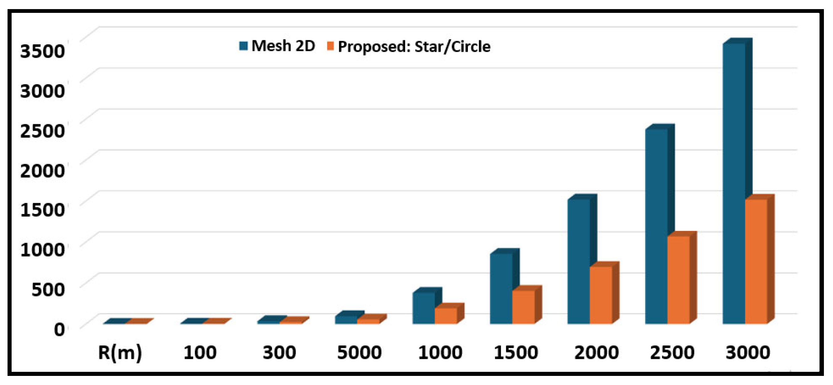
  • A novel hybrid star/circular WSN topology optimized for remote forest environments, reducing node deployment by 53–55% compared to conventional Mesh 2D topologies while ensuring robust coverage through concentric tiered arrangements adaptable to flat or mountainous terrain.
  • An adaptive routing framework supporting dynamic vertical inter-tier jumps and priority-based arbitration, reducing latency by 41–81% and hops by 50–60% in dense forests while maintaining connectivity during node failures or congestion.
  • A lightweight AI-driven fire-risk classifier using multiclass logistic regression on real-time temperature/humidity data, achieving 99.97% accuracy with minimal computational overhead, validated against meteorological datasets from Saudi Arabia.
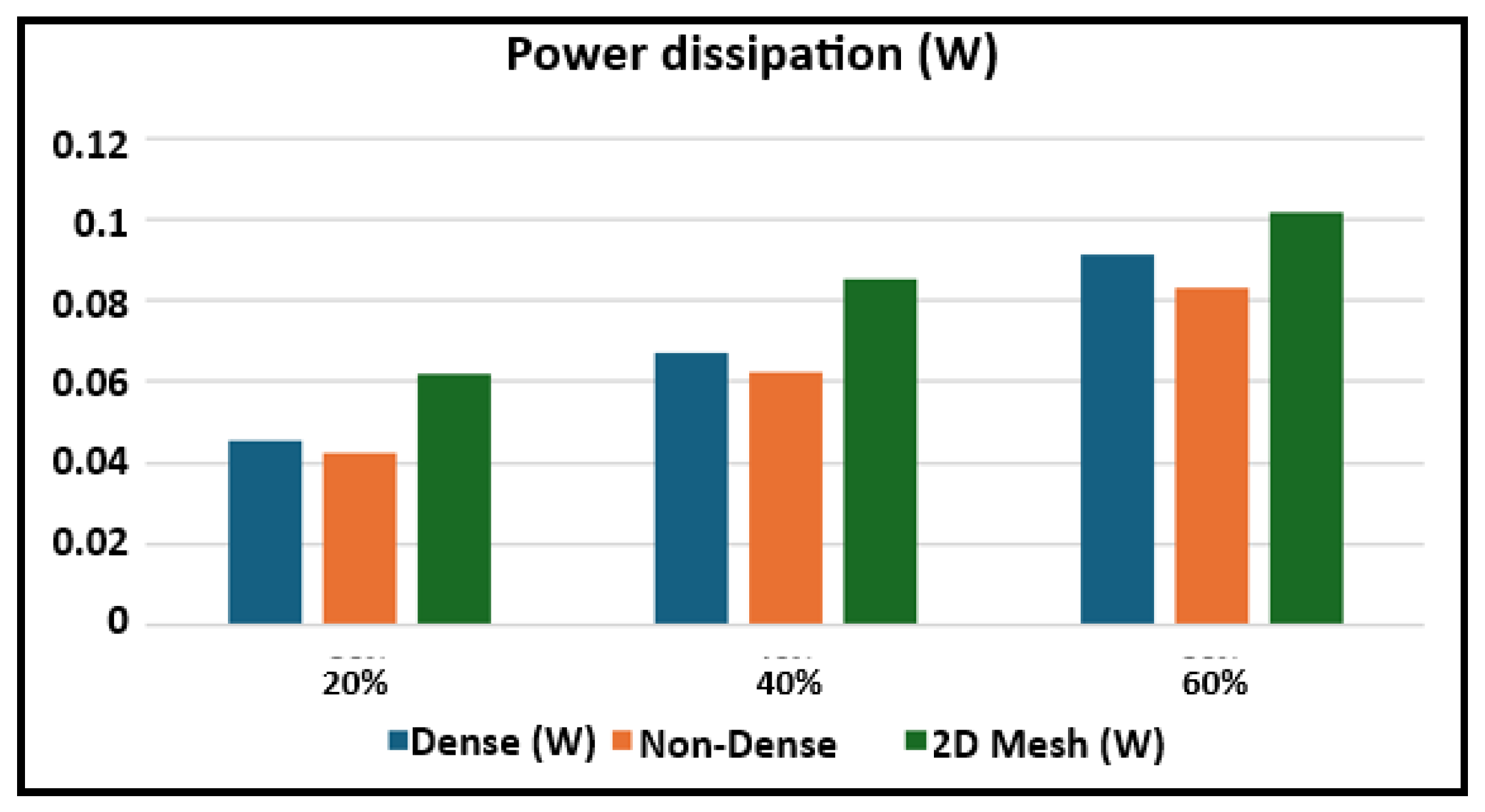
  • Comprehensive simulation-based validation demonstrating superior packet loss reduction (up to 80.4%), energy efficiency (0.0425–0.0832 W in non-dense topology), and scalability across diverse forest densities using Proteus (hardware-level) and CupCarbon (network-level) tools.
  • Practical deployment innovations, including GSM integration for offline alert transmission, dynamic round-robin arbitration for conflict resolution, and topology configurability for mixed terrains, ensuring cost-effective and reliable operation in resource-constrained areas.
Together, these advances deliver a scalable, energy-efficient, and terrain-resilient solution addressing critical gaps in existing WSN-based wildfire detection systems.
The remainder of the paper is organized as follows. We describe the related works in Section 2. We present the proposed architecture and methodology in Section 3. Effectiveness and efficiency evaluation results are described in Section 4. We conclude the paper in Section 5.

2. Literature Review

The detection of forest fires is a critical problem that has garnered significant attention in recent years due to its high environmental and economic impact, leading to the development of various technologies to overcome the limitations of traditional systems. WSNs are now central to modern wildfire detection, addressing the inefficiencies and delays of traditional methods such as towers, cameras, and satellites, which are limited by weather and image acquisition frequency [9].
Over the years, WSNs have evolved to address these challenges. Early studies focused on integrating WSNs with environmental sensors, including temperature, humidity, and smoke detection sensors, to create reliable, low-cost, and energy-efficient monitoring systems. In [19], Somov discussed the significant challenges in routing for energy efficiency in WSNs. Gomathi et al. [20] presented a ZigBee-based system to enhance the reliability of fire detection while reducing delays and energy consumption. Sabit et al. [21] emphasized the advantages of WSNs in real-time fire prediction, as their system provides superior spatial and temporal resolution compared to satellite-based approaches.
The integration of artificial intelligence (AI) and the Internet of Things (IoT) has significantly enhanced wildfire detection systems by leveraging real-time environmental data and complex algorithms for more accurate and timely predictions. Bahrepour et al. [22] pioneered AI-based fire detection systems, using AI to distinguish real from false alarms in residential fire systems. Ko et al. [23] developed an intelligent WSN for early detection by analyzing real-time environmental parameters like temperature and smoke. Recent advancements focus on combining machine learning (ML) and deep learning (DL) with WSNs for real-time wildfire prediction. For instance, Pradeep et al. [24] proposed a robust ML framework, leveraging AI for fire events in a variety of environments. Varela et al. [25] applied information fusion techniques to enhance detection accuracy, achieving 100% detection in controlled settings and emphasizing energy efficiency for real-world applications. Recent works by Attia et al. and Bhamra et al. explored using machine learning to improve fire detection accuracy by analyzing sensor data for early prediction. These studies focus on machine learning models to detect fire hazards early [26,27]. Yang et al. [28] incorporated IoT-based WSN systems with advanced algorithms that fuse environmental data in real time, optimizing power consumption and detection accuracy. In [29], Benzekri et al. incorporated deep learning to refine wildfire detection by identifying complex patterns in sensor data and images, making the system adaptable to diverse environmental conditions. In [30], Marjani et al. developed a hybrid AI model combining Convolutional Neural Networks (CNNs) and Recurrent Neural Networks (RNNs) to predict wildfires, significantly reducing false negatives in detection systems. AI models have been enhanced by hybrid IoT-AI systems combining real-time sensor data and satellite imagery. In [31], Avazov et al. integrated smoke and gas sensors with deep learning for fire classification, improving the monitoring of large forest areas by reducing false alarms and enhancing detection accuracy.
The choice of network topology is crucial for optimizing WSN performance in wildfire detection systems. Various topologies, such as ring, star, mesh, and tree, have been explored, each with distinct benefits and limitations. Mulligan et al. [32] highlighted the importance of coverage in WSNs and the trade-offs between different deployment schemes. Abbasi et al. [33] reviewed energy-efficient topology control techniques to enhance data transmission and network efficiency in wireless ad hoc networks. To address the limitations of traditional WSN configurations, some studies have proposed hybrid and dynamic topologies. For instance, Jiang et al. [34] introduced a hybrid topology that merges star and mesh structures to enhance the coverage and fault tolerance in wildfire-prone areas, optimizing energy use and communication efficiency for reliable fire detection and fast data transmission.
Recent advances in wildfire detection have increasingly leveraged emerging technologies such as LoRa/LoRaWAN-based WSNs and AI, which complement traditional methods in terms of scalability, cost-efficiency, and responsiveness. For instance, a low-cost WSN deployed in the New Forest, UK, used LoRaWAN to transmit over 7500 environmental measurements at 30 min intervals, demonstrating enhanced spatial and temporal monitoring capabilities [35]. In a separate deployment in India’s Eturnagaram Wildlife Sanctuary, a Forest Protection System (FPS) integrating multiple sensors with Arduino Nano boards and LoRaWAN communication achieved 97.14% accuracy in intrusion detection and 100% accuracy in fire detection [36]. Moreover, Brito et al. [37], proposed an energy-efficient LoRaWAN system using filtering algorithms (e.g., Exponential Smoothing, Moving Averages, Least Squares), with their combined filter (DROWSIER) reducing energy usage by 53% while maintaining timely fire detection. On the other hand, AI has proven particularly effective in enhancing the early detection of wildfires. A system using 44 CO2 sensors and AI models such as AutoEncoders and LSTM networks significantly improved sensor activation and detection performance, outperforming basic threshold-based methods by up to 56% [38]. These technologies provide robust foundations for real-time analysis, the prediction of fire front propagation, and improved decision-making in fire management. Accordingly, they have been discussed and cited in this work to broaden the technological context and reinforce the relevance of the proposed system.
In WSNs for wildfire detection, efficient energy use is vital due to remote deployment locations. Recent research has focused on techniques like duty cycling, adaptive transmission power control (ATPC), and renewable energy harvesting. Cheour et al. [39] advanced this area by integrating hybrid solar and wind energy into a WSN model, significantly extending sensor node lifespan in remote forest areas where long-term deployment is essential.

3. WSN Architecture

The proposed star/circle WSN topology seeks to create a sustainable, efficient monitoring system for long-term sensor node deployment across diverse forest types. A key aspect of the methodology is determining the optimal number and arrangement of sensors for balanced coverage. Strategic deployment tackles challenges posed by varying forest conditions, while efficient placement is essential for testing routing protocols, optimizing connectivity and data integrity over different distances and densities, and overcoming communication barriers in dense canopies.

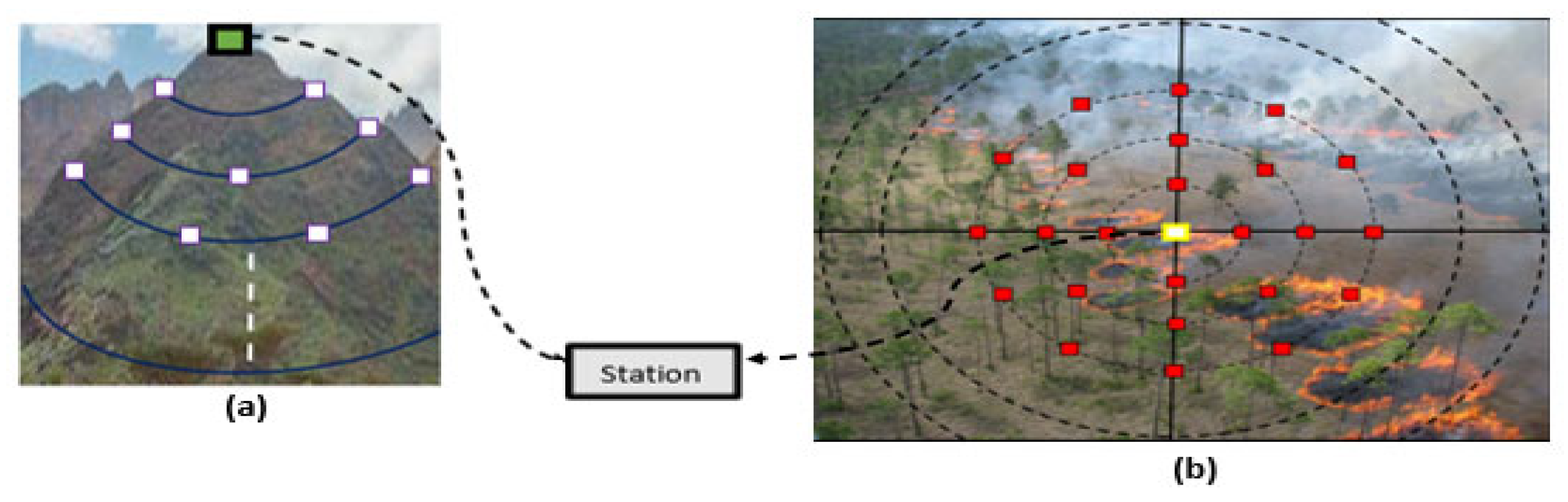
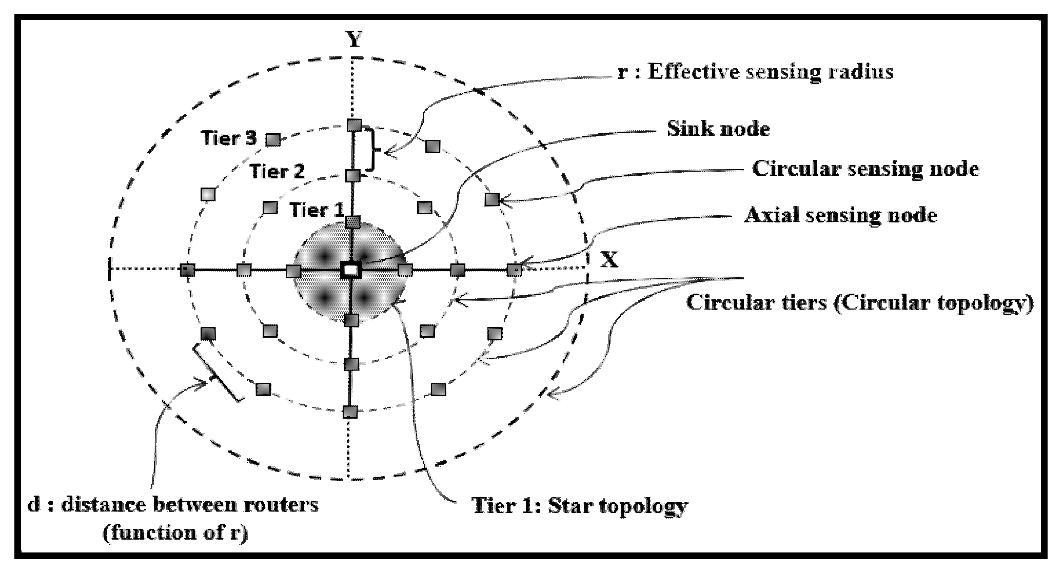
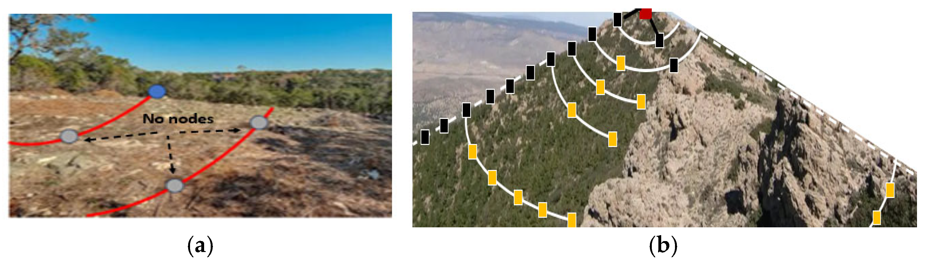
3.1. Star/Circle Topology

In the proposed WSN topology, nodes are arranged in concentric flat or pyramidal circles based on forest type (flat or mountainous), as illustrated in Figure 1. The network design considers forest density, terrain, and the use of the Zigbee protocol for node communication. Operating at 2.4 GHz, Zigbee may face interference from other wireless signals (e.g., Wi-Fi, Bluetooth), especially near urban areas. However, this is negligible in the targeted remote forests. Terrain features like hills, as well as weather conditions such as rain or fog, can further reduce signal range. Under optimal conditions, Zigbee can reach 50–100 m, but in dense vegetation, the range may drop to 10–20 m or less. These factors are accounted for in the WSN architecture and sensor node deployment.
The WSN architecture (Figure 2) combines two topologies: star and circle. In star topology, a central sink node is surrounded by four sensing nodes aligned along its axes. Due to the distance exceeding their sensing range, these nodes cannot communicate directly with each other. Instead, they transmit data to the sink node upon detecting fire or act as intermediaries to relay data from nodes in the surrounding circular tiers.
The circular tiers are centered around the sink node, with radii increasing by multiples of n × r, where r is the effective sensing radius. Key nodes are placed along the axes at angles 0, π/2, π, and 3π/2 in each tier. The spacing between consecutive axis nodes equals the effective sensing radius, determined by forest type, density, and terrain. Within each tier, adjacent nodes are placed at distances less than or equal to r, ensuring reliable communication when needed.
In non-dense forests, the distance between circular tiers may exceed the effective sensing radius. In this case, the system relays data between nodes along the same circle until it reaches an axis node, which then forwards it to the sink. In dense forests, tier spacing is reduced to within the maximum effective radius, enabling communication between adjacent tiers. This enables faster data transmission during fire spread and enhances responsiveness.

3.2. Node Deployments

A key challenge in WSN architecture design is balancing energy efficiency with full area coverage, which requires optimal sensor density. As the distance from the network center increases, the circle radius grows, necessitating more nodes per tier. Based on node count and spacing, a network may be classified as dense or sparse. The proposed deployment strategy features low density (compared to typical mesh networks), flexibility, and adaptability to different forest types and terrains. It also ensures a balanced and organized layout.
To calculate the total number of sensing nodes: each circle includes four mandatory axis nodes. The number of nodes in one-quarter of a circle (between two axis points) is computed first, then multiplied by four to obtain the total per circle. These nodes are evenly spaced between axes, based on their number, the circle’s radius, and the effective sensing radius. The overall node count includes all circular tier nodes plus the four star-tier axis nodes. Consider the following:
  • N: total number of sensing nodes in the network;
  • A: area of the forest;
  • R: radius of the flat forest area;
  • NC: total number of circular tiers;
  • r: effective sensing radius;
  • d: distance between two neighboring nodes on a circle (dependent on r);
  • Ni: index (order) of the circle;
  • n: number of nodes in a circle.
The effective sensing radius r is determined by sensor specifications, communication requirements, and environmental constraints. Sensor requirements define the maximum trustworthy detection range for temperature/humidity variations under ideal conditions. Environmental aspects, such as vegetation density, terrain altitude, wind patterns, and atmospheric interference, further modulate this range by attenuating signals or blocking the line of sight. For example, dense forests reduce r to 10–20 m due to signal absorption, whereas open areas permit r ≈ 100 m. Communication likelihood via ZigBee (constrained by IEEE 802.15.4’s range limits) also imposes r, guaranteeing nodes stay within a reliable relay distance. Thus, r is calibrated via site surveys, empirical validation, and prior studies (e.g., [13,14,20]) to balance coverage, energy efficiency, and detection consistency. In simulations (Section 4), r = 100 m represents a moderate baseline for open forests, but real deployments adjust r dynamically per terrain.
The area of a flat forest is given by A = π R 2 . Therefore, the radius of the forest area is R = A π . The total number of circles is then N C = R r = A π r 2 .
Equation (1) gives the total number of sensing nodes in the WSN:
N = 4 N u m b e r   o f   s t a r   n o d e s + 4 { [ 2 r π / 4 r ] + 1 } + 4 { [ 3 π r / 4 r ] + 1 } 4 { N C r π / 4 r ] + 1 } N u m b e r   o f   n o d e s   b e t w e e n   t w o   a x e s   o f   t h e   c i r c l e   o r d e r   N C N u m b e r   o f   n o d e s   o f   t h e   c i r c l e   o r d e r   N C  
Note that the function ⌊x⌋ represents the floor function to ensure integer node counts. For example, ⌊ 2 π 4 ⌋ = 1. The simplified network density equation (Equation (1)) is given by Equation (2).
N = 4 N C + 4 i = 1 N C   ( i π 4 + 1 )
Once the number of nodes is determined, the next step is to calculate the spacing distance, d, between each pair of nodes. To compute the spacing between nodes in each quarter of a circle with order Ni, the corresponding circle radius Ri is calculated as a function of the effective sensing radius r ( R = N i r ). Multiplying this radius by the quarter angle π 4 gives the total distance between the two axis nodes of the circle, i.e., N i r × π 4 . Assuming n is the number of nodes required in a quarter of the circle ( n = N i π 4 ), the total distance is divided by (n + 1). Thus, for any circle of order Ni, distance d between nodes is given by Equation (3):
d = N i π 4 × r n + 1 ; n = x = N i π 4     d = N i π r 4 ( N i π 4 + 1 )
For example, in a forest area with R = 1000 m and an effective sensing radius r = 100 m (topology with one star and 9 circles), the spacing distance d for x = 6 π 4 = 4.71 (n = x = 4) is calculated as 6 π 4 × r 5 = 94.2   m .

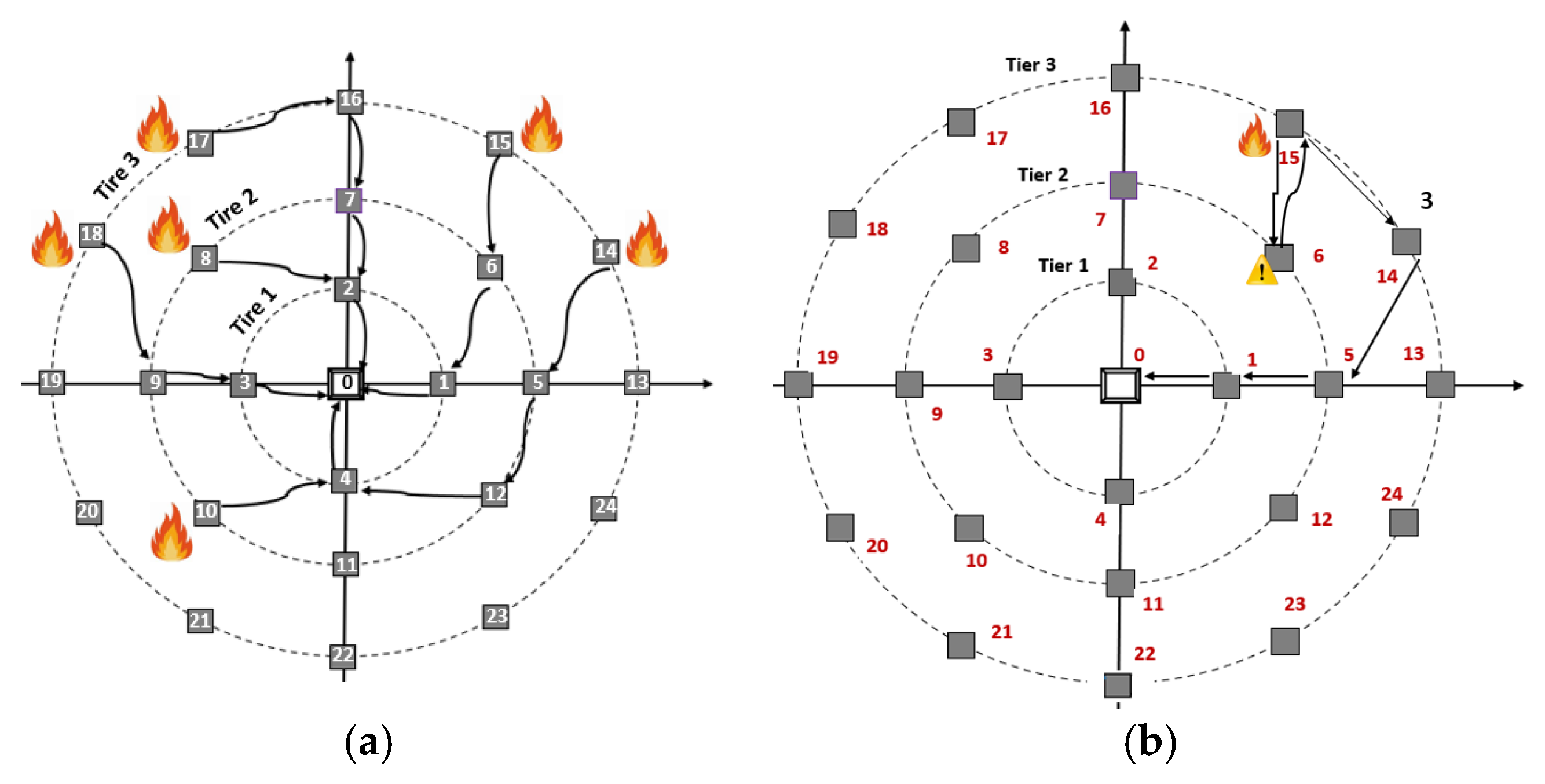
3.3. Routing Algorithms and Applications

Forests vary greatly in density and topography, ranging from dense, tall-tree areas to open, sparsely vegetated spaces, with terrain that can be flat or mountainous. This diversity requires a highly adaptable and flexible WSN for effective environmental monitoring. To address these challenges, a hybrid network system combining multiple structures will provide comprehensive coverage and efficient data transmission across different forest conditions. The hybrid WSN architecture ensures adaptability in both dense and open terrains, whether flat or rugged. This flexibility allows for the optimization of sensor numbers, efficient deployment, and the selection of appropriate routing algorithms. Different routing algorithms can be employed in the proposed network configurations. Mixed forests where some areas are treeless and others are dense or sparse can also be encountered. In these forest types, the WSN design excludes the treeless regions, focusing on the other region to deploy the sensing nodes. Figure 3 illustrates some examples of truncated flats and mountainous forests and the corresponding node deployments.
The proposed WSN architecture supports the integration of adaptive, semi-adaptive, and deterministic routing algorithms, tailored for wildfire detection. Adaptive routing dynamically adjusts paths to network changes, ensuring rapid rerouting during failures—ideal for dense forests requiring emergency responsiveness. Semi-adaptive routing balances flexibility and cost, using fixed paths but adapting selectively, reducing overhead for non-critical tasks. Deterministic routing is limited to redundant setups. For non-dense forests, a hybrid adaptive–semi-adaptive approach optimizes adaptability and efficiency. A dynamic arbitration scheme resolves conflicts by prioritizing critical data (e.g., fire alerts), queuing lower-priority transmissions to prevent deadlocks and ensure timely delivery to the central host. Dynamic arbitration is used to ensure equitable data processing, preventing any node from being indefinitely delayed. This hierarchy ensures robustness across varying forest topologies and operational demands.

3.3.1. Routing in Dense Forests

In dense forests, network tiers are positioned closely (inter-tier distance ≤ effective sensing radius) to address high environmental obstruction density. This proximity enables adaptive routing algorithms to dynamically reroute data around obstacles (e.g., thick vegetation) through adjacent upper/lower tiers if intra-tier paths are blocked. Critical alerts (e.g., wildfires) bypass blockages via these verticals rerouting, ensuring delivery to the control center. Inter-tier communication enhances resilience by allowing direct data jumps between tiers, eliminating dependency on horizontal paths. In mountainous terrain, nodes adopt a conical configuration around peaks to maximize coverage across elevations while maintaining tiered connectivity. Figure 4 illustrates an example of possible inter-tier adaptive routing in the case of a flat forest.
In this example, fires are detected at nodes 8, 10, 14, 15, 17, and 18. The adaptive routing algorithm aims to minimize energy use and avoid unnecessary transmissions. Figure 4a illustrates possible paths for forwarding fire alerts to the sink node. For instance, node 14 sends data to node 5 in the lower tier. When node 5 detects that axis node 1 is busy handling data from node 15 via node 6, it forwards the message to node 12. To reduce latency and prevent data blocking, node 12 routes through node 4, which may also be receiving data from node 10. If nodes 10 and 12 simultaneously request access to node 4, dynamic arbitration decides the priority—e.g., if node 12 arrives first, node 10 is queued. Alternatively, node 5 could wait until axis node 1 becomes free. Adaptive inter-tier routing also proves effective when nodes fail. As shown in Figure 4b, if node 15 detects that node 6 is inactive, it reroutes its data through node 14 to maintain communication continuity.

3.3.2. Routing in Non-Dense Forests

In non-dense mountainous and flat forests, where vegetation and trees are sparsely distributed, the number of WSN tiers and nodes is optimized accordingly. The spacing between consecutive circles can exceed the maximum sensing radius, concentrating nodes in areas with vegetation. Axis nodes are always present, with consecutive ones separated by the effective sensing radius. In this setup, inter-tier routing is disabled—nodes cannot transmit across different tiers. The hybrid adaptive–semi-adaptive routing algorithm is ideal here. Nodes within each tier are divided into quadrants, and data transmission is limited to neighboring nodes within the same tier and quadrant, either clockwise or counterclockwise. Data is relayed within the circle until it reaches the appropriate axis node, which then forwards it along the axis path to the sink node.
Figure 5 illustrates the application of the hybrid adaptive–semi-adaptive routing in forest fire scenarios. Inter-tier and inter-quadrant communication is restricted, allowing only clockwise and counterclockwise data flow within the same quadrant and tier. Fires are detected at nodes 0, 4, 6, 8, 9, 14, 15, 18, and 20. Blue arrows represent data originating from the node itself, while red arrows indicate forwarded data. Nodes 1 to 4 on the star-shaped circle send data directly to the sink. Node 15 routes its data to the nearest axis node 16, which forwards it along the axis to the sink. If node 7 receives simultaneous data from node 6, two-level dynamic arbitration is applied. Similarly, node 9, which has a fire and receives data from nodes 8 and 19, triggers two-level arbitration if the data arrives at once. In case of a fire at the sink (node 0) while receiving data from its four surrounding nodes, five-level dynamic arbitration ensures that GSM-based transmission to the control center proceeds smoothly.

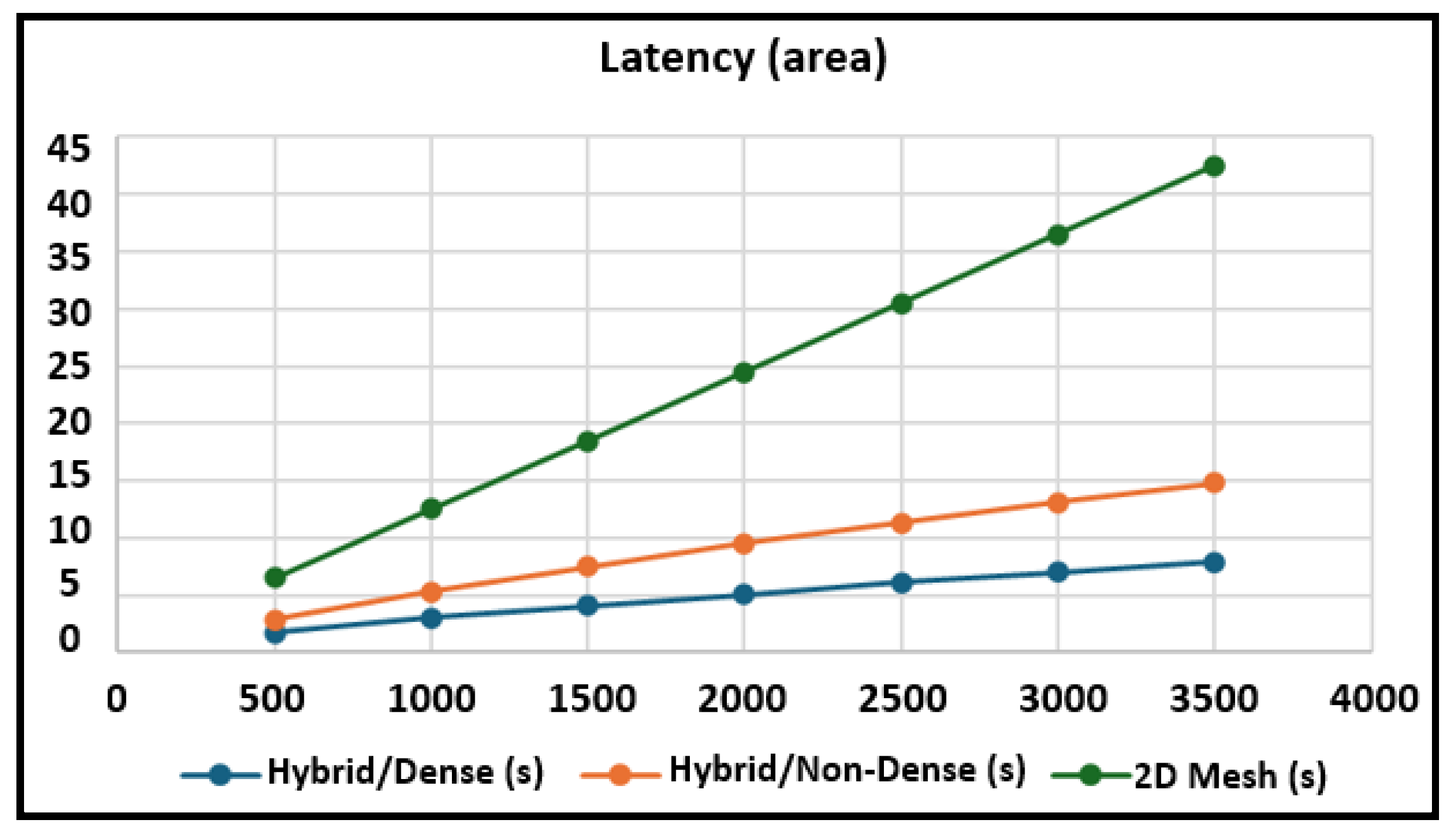
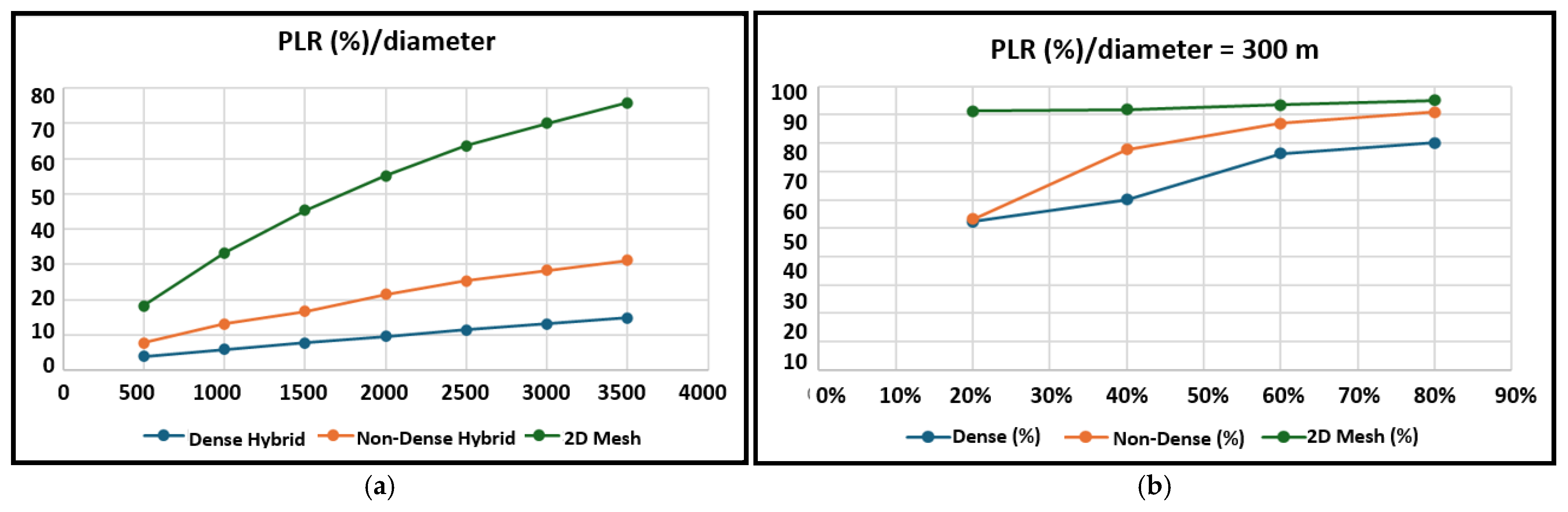
3.4. Latency and Packet Loss

The total end-to-end latency L is calculated using Equation (4) as follows [40,41].
L = h · t t x + t p r o c + t q u e u e + t r e r o u t e
With h : number of hops, t t x : transmission time per hop, t p r o c : processing time per node, t q u e u e : queuing delay per node, and t r e r o u t e : additional delay due to adaptive rerouting.
For the hybrid dense topology, vertical rerouting enables direct jumps between tiers (concentric circles), eliminating intra-tier detours. Each tier has a radius increment of 100 m (distance from the sink). Therefore, the diameter increment per tier is 2 × 100 m = 200 m. The number of hops is given by Equation (5).
h = D i a m e t e r T i e r   d i a m e t e r   i n c r e m e n t = D i a m e t e r 200
In fact, since hybrid dense topology allows data to jump vertically between tiers, bypassing horizontal obstacles, the number of hops is reduced compared to purely horizontal routing. The square root reflects the multi-dimensional optimization of the network.
For the hybrid non-dense topology, there is no vertical rerouting, and the data travels intra-tier to axis nodes, then sequentially to the sink. The number of hops is given by Equation (6).
h = D i a m e t e r 200 + l o g 2 ( D i a m e t e r 200 )
In fact, in non-dense topology, vertical rerouting between tiers is disabled. Instead, the data must travel horizontally within the same tier until it reaches an axis node. This introduces two components to the total hop count (tier-to-tier hops, basic linear scaling with diameter ( D i a m e t e r 200 ), and intra-tier detours). Intra-Tier detours are additional hops required to navigate within a tier to reach the nearest axis node. The logarithmic term approximates the average number of detour hops needed to reach an axis node within a tier as the network scales. It ensures the hybrid topology remains efficient in non-dense forests, even without vertical rerouting. This approach balances realism and simplicity, reflecting observed routing behavior in sparse deployments.
The above equations show that the proposed topology requires fewer hops than 2D Mesh, which suffers from linear hop growth and no vertical rerouting, causing higher latency. The number of hops in the case of the 2D Mesh topology is given by Equation (7).
h = D i a m e t e r A v e r a g e   h o p   d i s t a n c e   = D i a m e t e r 50
In fact, in the 2D Mesh topology, nodes are placed in a grid where each node communicates directly with its immediate neighbors (up, down, left, and right). So, the average hop distance (50 m) ensures reliable communication between nodes while balancing signal strength.
The Packet Loss Rate (PLR) depends on the topology number of hops h as shown in Equation (8) [42,43]. So, packet PLR varies significantly across the proposed topology and the 2D Mesh topology due to differences in routing efficiency and hop count scaling.
P L R = 1 i h   ( 1 P l o s s ,   i )

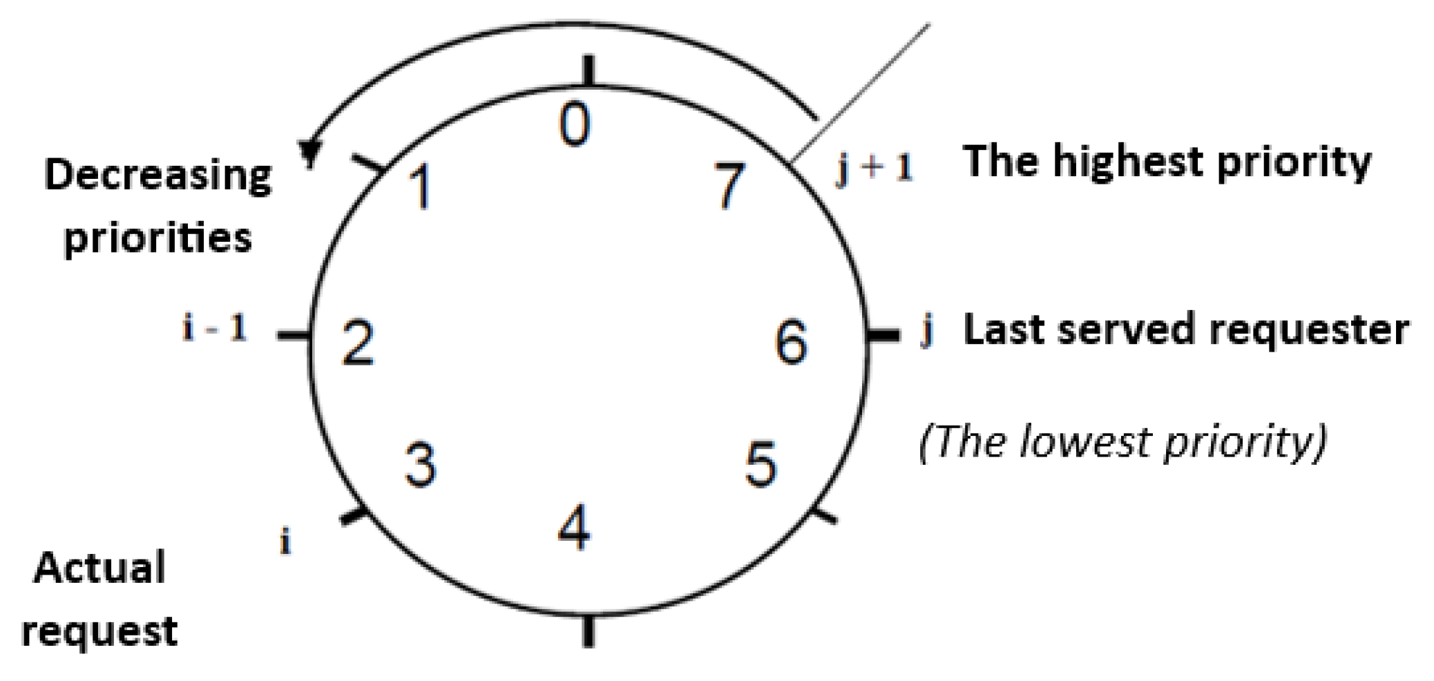
3.5. Sensor Node Arbitration

ZigBee, based on IEEE 802.15.4, is optimized for low-power, low-data-rate wireless communication [44]. Efficient packet structure is essential for performance. In the proposed design (Table 1), the payload allocates two bytes for device ID, two for a unique header (UH) to ensure reliable delivery, one byte for priority and status flags (e.g., battery level, sensor errors), and two bytes for temperature and humidity readings.
Unlike static arbiters, dynamic arbiters can adjust priority orders in real time [45], enabling more effective bandwidth allocation. Their primary advantage lies in their ability to prevent starvation, making them well-suited for shared-access systems such as Multiprocessor Systems on Chip (MPSoCs) and Networks on Chip (NoCs), especially in asynchronous systems [46,47,48,49,50]. In WSNs, arbitration schemes address issues of fairness and starvation while optimizing energy consumption during communication [51,52,53,54,55]. These schemes are typically implemented on the Medium Access Control (MAC) layer, where conventional protocols often lack prioritized channel access and may suffer from inconsistent fairness.
To handle access conflicts in the proposed forest fire detection system, where multiple sensor nodes may simultaneously attempt to reach the same intermediate node, a dynamic arbitration mechanism is implemented within each router. This mechanism assigns priorities based on fire urgency, reducing the average response time to the control center. Each data frame includes two priority bits (high: 10, medium: 01, and low: 00) embedded as the first two bits of the priority-level byte. Priority is determined by fire severity and the estimated likelihood of occurrence, as evaluated by an AI model analyzing temperature and humidity data.
Under the proposed strategy, the sensor node with the highest priority is granted access during each request. If multiple nodes share the same priority, access is rotated in a round-robin manner after each successful transmission. Once access is granted, the requesting node is moved to the end of the priority queue, preventing resource domination and ensuring fair access. Figure 6 illustrates the round-robin priority shift: when requester Xi seeks access and Xj was the most recently served, Xj holds the lowest priority. Xi gains the highest priority only if none of the requesters between Xj+1 and Xi−1 have submitted access requests. Based on the above specifications, the round-robin algorithm implemented in the sensor node arbiter is illustrated in Algorithm 1.
Algorithm 1: Round-robin algorithm
Input:
      X [0…n − 1]: Array of request signals (1 = active, 0 = inactive)
      P [0…n − 1]: Priority list (round-robin)
      N: Rank register
      n: Total number of requesters
Output:
      Z [0…n − 1]: Grant signals
      Wait until any X(i) = 1 for i = 0 to n − 1
      status ← X [0…n − 1]                                                   //Identify active requests
      Nb ← CalculateRequesterNumber (status)             //Count number of active requests
if Nb ≥ 1 then
                i ← SelectRequester (status, P)                       //Choose the highest priority requester
                Z(i) ← 1                                                            // Grant access
                Wait until X(i) = 0                                           //Wait for requester to finish
                Z(i) ← 0                                                           // Revoke access
                j ← FetchPriorityOrder (P, i)                        //Get position of granted requester
                P ← Concatenate (P [j + 1…n − 1], P [0…j − 1], P[j])     //Update round-robin priority
end if

3.6. AI-Based Fire Risk Prediction Approach

To enhance fire hazard prediction and improve system accuracy, artificial intelligence (AI) techniques were integrated into wireless sensor network (WSN) nodes. For predictive modeling, multiclass logistic regression algorithms were used to derive equations that relate temperature and humidity measurements to the three fire risk levels: low, medium, and high [56]. These models were trained on real environmental data, enabling the system to adapt to various conditions. They predict fire risk levels (low, medium, and high) based on environmental conditions that precede ignition, such as elevated temperatures and reduced humidity. This enables proactive intervention before fires start. Once the data packet is received and verified, the receiver computes the fire risk probability using Equation (9):
f = a t + b h + c  
Here, t is temperature, h is humidity, a and b are coefficients from training that reflect their influence, and c is a bias term to improve accuracy. This equation was developed through several stages. Initially, a large meteorological dataset containing temperature, humidity, and other weather variables (wind speed, pressure, and visibility) from 13 cities in Saudi Arabia was used, including over 249,000 recorded entries [57].
The multiclass logistic regression model was implemented using the Scikit-learn library with the multinomial option and the lbfgs solver. This approach learns distinct linear functions for each fire risk class (low, medium, and high), defined as Equations (10)–(12):
L o w   r i s k   ( f 0 ) : f 0 = 10.75 t + 0.084 h + 350.05  
M e d i u m   r i s k   ( f 1 ) : f 1 = 1.13 t + 0.07 h 0.22  
H i g h   r i s k   f 2 : f 2 = 9.62 t 0.15 h 349.83  
These equations are automatically fitted during training on the meteorological dataset [57], where humidity is input as a raw numerical value (e.g., 65). The model computes all three scores ( f 0 , f 1 , and f 2 ) for incoming sensor data. The class with the highest raw score f i is predicted, as arg max ( f i ) aligns with the highest softmax probability. The coefficients and intercepts reflect the relative influence of temperature and humidity on each risk category, optimized via gradient descent on cross-entropy loss, maximizing the likelihood of correct risk-level predictions on the training data.
We recognize the Canadian Fire Weather Index (FWI) [58] as a comprehensive and validated model for wildfire risk assessment. Nevertheless, its dependence on various weather inputs and iterative calculations makes it inappropriate for low-power WSNs. The proposed simplified model, based only on temperature and humidity, achieves 99.97% accuracy by learning patterns that approximate key FWI thresholds (e.g., >30 °C and <30% humidity ≈ high risk) [58]. Logistic regression effectively captures the non-linear relationships involved, balancing accuracy and feasibility.
The digitized data was divided into training and testing sets to ensure effective evaluation. Temperature and humidity served as inputs, while fire risk levels were the outputs. To handle classification, a multi-class logistic regression model was built using the scikit-learn library. It was configured to classify inputs into the three risk categories. During training, the model adjusted coefficients (a and b) and the bias term c to link inputs with risk levels. It produced three output values ( f 0 , f 1 , and f 2 ), each representing a fire risk category. The highest value determined the final risk classification.

4. Experimental Results

The performance of the proposed system was evaluated using Proteus 8 Professional and CupCarbon simulation tools [59,60].

4.1. Proteus Simulation

Proteus was used to simulate the hardware functionality of both the transmission and receiving nodes. Each node was built around an Arduino Uno microcontroller. The transmission node incorporated a DHT11 sensor to measure temperature and humidity [61] and used an XBee ZigBee module for wireless communication. The receiving node, also equipped with an XBee module, relayed the data to a central monitoring station via a GSM SIM900D module. This module sends alert notifications over the mobile network, including the fire status, its computed index, and the corresponding temperature and humidity readings [62].
Multiclass logistic regression is used for predictive AI modeling to classify fire risk based on temperature and humidity. The categorical fire risk variable is encoded numerically (0 = Low, 1 = Medium, and 2 = High) to enable supervised learning. The model is trained using an 80/20 train–test split and achieves 99.97% accuracy, evaluated with a custom accuracy function. Decision boundaries are visualized to illustrate how the model distinguishes between risk levels. The system also supports real-time prediction for new inputs and calculates raw scores using the model’s learned coefficients.
Figure 7a illustrates the relationship between temperature (x-axis), humidity (y-axis), and fire occurrence (color scale). Each point represents a data sample, with color intensity reflecting fire likelihood on a continuous scale from 0 (no fire) to 2 (high risk). Risk levels signify the probability of fire ignition under given environmental conditions, not the direct detection of active fires. The plot shows that high temperatures and low humidity correlate with increased fire risk, highlighted by the concentration of yellow points in the lower-right region.
As illustrated in Figure 7b, for a temperature of 32 °C and a humidity level of 65, the three output values ( f 0   11.45 , f 1     40.50 , and f 2   51.95 ) are generated by the equation corresponding to the fire risk levels (Equations (10)–(12)).
Since the highest value corresponds to equation f 2 , the resulting risk level is classified as medium, which aligns with the simulation result as shown in Figure 7. Importantly, ‘High Risk’ indicates conditions conducive to fire ignition (e.g., dry, hot vegetation), not active burning. Active fire detection would require additional sensors beyond temperature/humidity.

4.2. WSN Simulation

The CupCarbon Network Simulator was used to evaluate the topology, routing, and energy efficiency of the wireless sensor network (WSN) across different forest environments. The simulations covered both dense and sparse forest scenarios, with performance compared to the conventional 2D Mesh topology. Three routing techniques were implemented: adaptive inter-tier routing (for dense forests), hybrid Adaptive–Semi-Adaptive (for sparse forests), and adaptive routing for 2D Mesh. Figure 8 shows a WSN designed using CupCarbon, representing a portion of a 2D mesh topology.

4.2.1. Topology Deployment Efficiency

The proposed star/circle topology employs structured circular arrangements to prioritize coverage in high-risk wildfire zones while reducing redundant node deployment. Figure 9 presents a comparison of node distribution strategies in WSN-based wildfire detection, contrasting the conventional 2D Mesh topology with the proposed star/circle approach. The node count for the 2D Mesh topology is calculated using Equation (13) [63].
N = 2 A π r 2 27
The results show that as the monitored area increases, the star/circle topology becomes significantly more efficient than 2D Mesh.
While both topologies require the same number of nodes at small scales (e.g., a 100 m radius), the star/circle approach reduces node count by 53% at a 1500 m radius and by 55% at 3000 m. This highlights its advantage in large-scale wildfire detection by improving energy efficiency and lowering deployment costs.

4.2.2. Latency and Packet Loss Analysis

Figure 10 presents tests conducted for forest areas with diameters ranging from 500 m to 3500 m. The total end-to-end latency L is calculated using Equation (4), assuming identical operating conditions across the three topologies. ( t t x = 0.2   s , t p r o c = 0.1   s , and t q u e u e = 0.3   s ,   t r e r o u t e = 0.5   s ).
The test results indicate that the proposed hybrid star/circle topologies demonstrate a significant latency advantage over the traditional 2D Mesh topology. The hybrid dense topology leverages vertical rerouting between tiers (with 100 m radius increments), reducing hop counts by 50–60% compared to non-dense and 2D Mesh topologies. This structural efficiency enables the dense hybrid architecture to achieve 41–47% lower latency than the non-dense hybrid and 73–81% lower latency than 2D Mesh. The non-dense hybrid, while constrained by intra-tier routing, still outperforms the mesh by 55–65% due to axis-based path optimization. While the non-dense hybrid lags slightly behind its dense counterpart, both significantly outperform the mesh in terms of energy efficiency and resilience to obstacles.
The Packed Loss Rate (PLR) quantifies the probability of end-to-end packet loss over a multi-hop network path. For a route with h hops, where each hop has an independent per-hop loss rate of 2%, the PLR is calculated using Equation (14) as a one-shot computation based on final transmission statistics. Despite assuming a uniform per-hop loss, the proposed star/circle topology outperforms 2D Mesh in terms of packet delivery efficiency ( P l o s s , i = 0.02 ) as shown in Figure 11a.
P L R = 1 ( 1 0.02 ) h = 1 ( 0.98 ) h
The PLR varies significantly across the three network architectures due to differences in routing efficiency and hop count scaling. The dense hybrid star/circle performs best, with the PLR rising gradually from 3.96% (500 m) to 14.87% (3500 m). The non-dense hybrid shows faster PLR growth, reaching 31.09%, while 2D Mesh performs worst, with the PLR climbing to 75.81% due to inefficient scaling. At 3500 m, the dense hybrid reduces the PLR by 52.2% compared to the non-dense hybrid and by 80.4% compared to 2D Mesh. These results highlight the importance of efficient, adaptive inter-tier routing. Dense hybrid’s design limits hop buildup, making it ideal for real-time, low-latency applications like wildfire detection.
Figure 11b presents the simulation results generated by the CupCarbon tool for a 300 m area, considering that ZigBee/IEEE 802.15.4 is limited in range and sensitive to interference and that sleeps are not scheduled. These results show that the dense hybrid star/circle topology achieves the lowest PLR for all fire diffusion percentages (20–80%), with a 17.3% improvement over 2D Mesh and 11.7% over non-dense at 60% diffusion. At 80%, dense maintains an 80.2% PLR, while non-dense and Mesh 2D exceed 91%. These high PLR values are explained by the fact that non-dense and Mesh 2D topologies are more affected by simulation considerations about ZigBee limitations and the absence of sleep scheduling. As fire spreads, node failures increase, degrading connectivity and amplifying packet loss. This explains that the dense topology’s adaptive routing dynamically reroutes data around compromised nodes, whereas non-dense and Mesh 2D networks suffer from redundant hops and inflexible paths.

4.2.3. Energy Dissipation Analysis

The simulation results generated by the CupCarbon tool (Figure 12) for a 300 m area demonstrate distinct energy dissipation patterns across the three network topologies, dense, non-dense, and Mesh 2D, in a small-scale wildfire monitoring area.
Particularly, the non-dense topology shows higher energy efficiency at all fire diffusion rates (20%, 40%, and 60%) compared to dense and Mesh 2D. This efficiency stems from its simplified single-tier architecture, which minimizes routing complexity, reduces hop counts, and avoids the overhead of dynamic inter-tier management needed in the dense topology. However, dense topologies excel in large-scale deployments through vertical rerouting and redundancy; their multi-layered design becomes counterproductive in confined areas, introducing unnecessary energy expenditure for maintaining tiered connections. In contrast, the Mesh 2D topology leads to the highest energy consumption due to linear hop scaling and lack of adaptive routing, judging it inappropriate for dynamic wildfire environments. The non-dense topology’s lower energy demand also aligns with optimized duty cycling, where nodes prioritize sleep modes during low activity and employ efficient burst transmissions under higher fire rates. These findings emphasize the vital role of topology adaptability: non-dense balances simplicity and functionality for small areas, whereas dense’s strengths emerge in expansive, obstruction-rich terrains. The results validate this paper’s emphasis on context-aware network design, promoting, for topology, a choice based on deployment scale and environmental dynamics to improve energy sustainability in remote wildfire detection systems. A further investigation into advanced duty-cycling protocols and real-world validation could refine these models for broader applicability. These results align with theoretical predictions [64] as given by Equation (15). In fact, the non-dense topology established higher energy efficiency in small-scale deployments due to reduced hop counts and simplified routing, while the dense topology’s multi-tier overhead underperformed in confined areas, as expected. Mesh 2D’s rigid grid structure confirmed its inefficiency, validating theoretical critiques of its linear hop scaling and lack of adaptability in dynamic wildfire scenarios.
P t o t a l = N D P t x + P r x + P i d l e + ( 1 D ) P s l e e p + C ( h 1 ) ( P t x + P r x )
With
  • N: Number of nodes in the network.
  • D: Duty cycle (fraction of time active), proportional to fire rate (e.g., D = 0.2 at 20% fire rate).
  • Ptx, Prx, Pidle, Psleep: Power consumed in transmit, receive, idle, and sleep states.
  • C: Number of data packets transmitted.
  • h: Average hop count (depends on topology).

4.2.4. Component Ablation Analysis

An ablation study (Table 2) isolates the impact of key system modules in a 300 m area at 60% fire diffusion. The baseline (Mesh 2D + fixed thresholds + static arbitration) shows high resource usage and low accuracy. Introducing the hybrid topology reduces nodes by 53% and energy by 33%, while adaptive routing more cuts latency by 5.6%.
Dynamic arbitration reduces the PLR by 3.6% through prioritized alert handling. Crucially, the AI model increases accuracy from 76.5% to 99.97% by replacing heuristic thresholds with data-driven risk prediction, confirming its indispensability for precise early warnings. Topology optimization provides foundational efficiency gains, while AI delivers diagnostic precision.

4.3. Computational Complexity Analysis

To thoroughly address scalability and efficiency, we analyze the computational complexity of the proposed system’s core components. This analysis confirms the architecture’s suitability for large-scale deployments in remote wildfire-prone areas.

4.3.1. Routing Complexity

The adaptive routing algorithms achieve sub-linear complexity through topology-aware optimizations. For dense forests, inter-tier routing enables vertical jumps between concentric circles, reducing path lengths to O ( N ) hops (Equation (5)). In non-dense forests, the hybrid adaptive–semi-adaptive approach limits intra-tier routing to axis nodes, yielding O ( N + log N ) complexity (Equation (6)). This represents a 50–60% reduction in hop count compared to 2D Mesh topologies, which exhibit linear O ( N ) scaling (Equation (7)). The tiered structure ensures routing decisions remain O ( 1 ) per hop, as nodes select dynamically neighbors without exhaustive path searches.

4.3.2. Arbitration and AI Inference

The dynamic round-robin arbiter resolves contention in O ( k ) time, where k is the number of contending nodes (typically kN due to quadrant-based segmentation). Priority updates require O ( 1 ) operations via round-robin shifts (Figure 6). For fire-risk prediction, the multiclass logistic regression model performs inference in constant time O ( 1 ) using pre-trained coefficients (Equations (9)–(12)). Real-time evaluation involves three fixed linear equations f ( t + b h + c ) , making it feasible for resource-constrained Arduino nodes.

4.3.3. Topology Deployment and Energy Efficiency

Node placement calculations (Equations (2) and (3)) are executed in O ( 1 ) per tier using closed-form geometric formulas. The star/circle topology reduces node count by 53–55% versus 2D Mesh (Equation (13), Figure 9), directly reducing deployment and maintenance overhead. Energy dissipation (Equation (15)) aligns with simulations (Figure 12): non-dense configurations minimize power (0.0425–0.0832 W) by leveraging O ( N ) routing, while dense topologies optimize the PLR through adaptive O ( N ) rerouting.

4.4. Comparative Analysis with State-of-the-Art Wildfire Detection Systems

To thoroughly benchmark the proposed architecture versus contemporary approaches, Table 3 compares key performance metrics across eight state-of-the-art WSN-based wildfire detection systems. The evaluation spans total power consumption, per-node efficiency, PLR, node density, and coverage area.
The proposed hybrid star/circular topology achieves the lowest total power (0.0718 W) and per-node consumption (0.003 W), outperforming Mesh 2D [6], Hierarchical Tree [11], and Dynamic Clusters [64] by over 50×. With only 24 nodes deployed over 0.2826 km2 (node density: 85 nodes/km2), it maintains a low PLR/node (2.08%), rivaling optimized star topologies [25] while avoiding the scalability limitations of dense deployments (e.g., 300–500 nodes [43]). This balance of minimal hardware, energy sustainability, and reliable data delivery validates the architectural improvements.

5. Conclusions

This paper describes an energy-efficient and scalable WSN architecture fitted for early wildfire detection in remote locations. By using a hybrid star/circular topology combined with adaptive routing protocols and round-robin dynamic arbitration, the proposed architecture exhibits sizable advances relatively to conventional Mesh 2D topologies. It achieves a 53–55% reduction in node deployment, 41–81% lower latency, and 50–60% fewer routing hops. The simulation results for a 300 m radius confirm the advantage of the non-dense topology in energy consumption (0.0425–0.0832 W), while the dense configuration proves most effective in optimizing the PLR, achieving up to an 80.4% reduction compared to Mesh 2D topologies.
Furthermore, the integration of artificial intelligence (multiclass logistic regression), allows high-precision fire risk prediction (99.97% in terms of accuracy) based on temperature and humidity sensor inputs. Combined with ZigBee and GSM technologies, the system guarantees robust communication in areas with limited or no internet coverage.
These results highlight practical advantages, including cost-effective deployment, adaptability to diverse areas, and improved sensitivity to fire risks. This architecture provides a promising foundation for next-generation wildfire detection systems and has the potential to support open environmental monitoring initiatives globally. Future work will consider lightweight FWI-inspired methods using additional IoT sensors.

Author Contributions

Methodology, A.Z.; Software, S.A., H.A.S., S.A.Q. and S.G.; Validation, H.A.S. and S.A.Q.; Formal analysis, S.G.; Data curation, S.A.; Writing—original draft, A.Z.; Writing—review & editing, S.G.; Visualization, S.A.; Supervision, A.Z.; Project administration, A.Z. All authors have read and agreed to the published version of the manuscript.

Funding

This research received no external funding.

Institutional Review Board Statement

Not applicable.

Informed Consent Statement

Not applicable.

Data Availability Statement

The original contributions presented in this study are included in the article. Further inquiries can be directed to the corresponding author.

Conflicts of Interest

The authors declare no conflicts of interest.

References

  1. Chowdary, V.; Gupta, M.K.; Singh, R. A Review on Forest Fire Detection Techniques: A Decadal Perspective. Int. J. Eng. Technol. 2018, 7, 1312–1316. [Google Scholar] [CrossRef]
  2. Safford, H.D.; Paulson, A.K.; Steel, Z.L.; Young, D.J.; Wayman, R.B. The 2020 California Fire Season: A Year like No Other, a Return to the Past or a Harbinger of the Future? Glob. Ecol. Biogeogr. 2022, 31, 2005–2025. [Google Scholar] [CrossRef]
  3. Yu, L.; Wang, N.; Meng, X. Real-Time Forest Fire Detection with Wireless Sensor Networks. In Proceedings of the 2005 International Conference on Wireless Communications, Networking and Mobile Computing, Wuhan, China, 26 September 2005; pp. 1214–1217. [Google Scholar]
  4. Jin, L.; Yu, Y.; Zhou, J.; Bai, D.; Lin, H.; Zhou, H. SWVR: A Lightweight Deep Learning Algorithm for Forest Fire Detection and Recognition. Forests 2024, 15, 204. [Google Scholar] [CrossRef]
  5. Khan, F.; Xu, Z.; Sun, J.; Khan, F.M.; Ahmed, A.; Zhao, Y. Recent Advances in Sensors for Fire Detection. Sensors 2022, 22, 3310. [Google Scholar] [CrossRef]
  6. Farej, Z.K.; Abdul-Hameed, A.M. Performance Comparison among (Star, Tree and Mesh) Topologies for Large Scale WSN based IEEE 802.15.4 Standard. Int. J. Comput. Appl. 2015, 124, 41–44. [Google Scholar] [CrossRef]
  7. Jaladi, A.R.; Khithani, K.; Pawar, P.; Malvi, K.; Sahoo, G. Environmental Monitoring Using Wireless Sensor Networks (WSN) Based on IoT. Int. Res. J. Eng. Technol. 2017, 4, 1371–1378. [Google Scholar]
  8. Al-Karaki, J.N.; Kamal, A.E. Routing Techniques in Wireless Sensor Networks: A Survey. IEEE Wirel. Commun. 2004, 11, 6–28. [Google Scholar] [CrossRef]
  9. Atighi, I.; Zhou, Z. Safeguarding Forest Ecosystems: Harnessing IoT for Fire Detection. Big Data Comput. Vis. 2023, 3, 146–153. [Google Scholar]
  10. Choi, H.-H.; Lee, K. Cooperative Wireless Power Transfer for Lifetime Maximization in Wireless Multihop Networks. IEEE Trans. Veh. Technol. 2021, 70, 3984–3989. [Google Scholar] [CrossRef]
  11. Kaur, P.; Kaur, K.; Singh, K.; Kim, S. Early Forest Fire Detection Using a Protocol for Energy-Efficient Clustering with Weighted-Based Optimization in Wireless Sensor Networks. Appl. Sci. 2023, 13, 3048. [Google Scholar] [CrossRef]
  12. Ferdoush, S.; Li, X. Wireless Sensor Network System Design Using Raspberry Pi and Arduino for Environmental Monitoring Applications. Procedia Comput. Sci. 2014, 34, 103–110. [Google Scholar] [CrossRef]
  13. IEEE 802.15.4-2020; Low-Rate Wireless Personal Area Networks (LR-WPANs). IEEE: New York, NY, USA, 2020.
  14. Vijayan, S.G.; Abd Rahman, N.A.; Harun, K.S. A Conceptual Framework of Zigbee Wireless Sensor Networks for Safety, Reliability and Security Improvement. AIP Conf. Proc. 2024, 2802, 190001. [Google Scholar] [CrossRef]
  15. Alvares, B.; Perez, E.; Trigueros, J.; Ho, J.; Ly, E.; Le, H.T. Development of a Solar-Powered Wildfire Detector System for Remote Locations with XBee and GSM Capabilities. WSEAS Trans. Comput. 2021, 20, 189–198. [Google Scholar] [CrossRef]
  16. Dasari, P.; Reddy, G.K.J.; Gudipalli, A. Forest Fire Detection Using Wireless Sensor Networks. Int. J. Smart Sens. Intell. Syst. 2020, 13, 1–8. [Google Scholar] [CrossRef]
  17. Ganesan, R.; Devika, R.; Kumar, N.R.; Devi, S.S. Forest Fire Monitoring System Based on GPRS and Zigbee Wireless Sensor Networks. Int. J. Adv. Inf. Sci. Technol. 2015, 4, 16–21. [Google Scholar]
  18. Salaria, A.; Singh, A. A Guide for Selection of Wireless Communication Technology for Effective and Robust Early Forest Fire Detection System. Bull. Electr. Eng. Inf. 2025, 14, 1026–1035. [Google Scholar] [CrossRef]
  19. Somov, A. Wildfire Safety with Wireless Sensor Networks. EAI Endorsed Trans. Ambient Syst. 2011, 11. [Google Scholar] [CrossRef]
  20. Gomathi, C.; Vennila, K.; Sathyananth, M.; Shriaarthi, B.; Selvarasu, S. Forest Fire Detection Using Wireless Sensor Network. Int. J. Eng. Res. Technol. (IJERT) 2015, 3, 4. [Google Scholar]
  21. Sabit, H.; Al-Anbuky, A.; GholamHosseini, H. Wireless Sensor Network-Based Wildfire Hazard Prediction System Modeling. Procedia Comput. Sci. 2011, 5, 106–114. [Google Scholar] [CrossRef]
  22. Bahrepour, M.; Meratnia, N.; Havinga, P.J. Use of AI Techniques for Residential Fire Detection in Wireless Sensor Networks. In Proceedings of the 5th IFIP Conference on Artificial Intelligence Applications & Innovations (AIAI 2009), Thessaloniki, Greece, 23–25 April 2009; pp. 311–321. [Google Scholar]
  23. Ko, A.; Lee, N.M.Y.; Sham, R.P.S.; So, C.M.; Kwok, S.C.F. Intelligent Wireless Sensor Network for Wildfire Detection. WIT Trans. Ecol. Environ. 2012, 158, 137–148. [Google Scholar]
  24. Pradeep, S.; Sharma, Y.K.; Verma, C.; Constantin, N.B.; Illés, Z.; Raboaca, M.S.; Mihaltan, T.C. Utilizing WSN and Artificial Intelligence to Detect Fires. In Proceedings of the 2022 11th IEEE International Conference on System Modeling & Advancement in Research Trends (SMART), Moradabad, India, 16–17 December 2022; pp. 424–428. [Google Scholar] [CrossRef]
  25. Varela, N.; Díaz-Martinez, J.L.; Ospino, A.; Zelaya, N.A.L. Wireless Sensor Network for Forest Fire Detection. Procedia Comput. Sci. 2020, 175, 435–440. [Google Scholar] [CrossRef]
  26. Attia, M.W.; Abu Zaher, B.A.; Nasser, N.H.; Al-Hour, R.R.; Asfour, A.H.; Abu-Naser, S.S. Predicting Fire Alarms in Smoke Detection using Neural Networks. Int. J. Acad. Inf. Syst. Res. 2023, 7, 26–33. [Google Scholar]
  27. Bhamra, J.K.; Anantha Ramaprasad, S.; Baldota, S.; Luna, S.; Zen, E.; Ramachandra, R.; Kim, H.; Schmidt, C.; Arends, C.; Block, J.; et al. Multimodal Wildland Fire Smoke Detection. Remote Sens. 2023, 15, 2790. [Google Scholar] [CrossRef]
  28. Yang, H.; Zhou, H.; Liu, Z.; Deng, X. Energy Optimization of Wireless Sensor Embedded Cloud Computing Data Monitoring System in 6G Environment. Sensors 2023, 23, 1013. [Google Scholar] [CrossRef]
  29. Benzekri, W.; El Moussati, A.; Moussaoui, O.; Berrajaa, M. Early Forest Fire Detection System Using Wireless Sensor Network and Deep Learning. Int. J. Adv. Comput. Sci. Appl. 2020, 11. [Google Scholar] [CrossRef]
  30. Marjani, M.; Ahmadi, S.A.; Mahdianpari, M. FirePred: A Hybrid Multi-Temporal Convolutional Neural Network Model for Wildfire Spread Prediction. Ecol. Inform. 2023, 78. [Google Scholar] [CrossRef]
  31. Avazov, K.; Hyun, A.E.; Sami S, A.A.; Khaitov, A.; Abdusalomov, A.B.; Cho, Y.I. Forest Fire Detection and Notification Method Based on AI and IoT Approaches. Future Internet 2023, 15, 61. [Google Scholar] [CrossRef]
  32. Mulligan, R.; Ammari, H.M. Coverage in Wireless Sensor Networks: A Survey. Netw. Protoc. Algorithms 2010, 2, 27–53. [Google Scholar] [CrossRef]
  33. Abbasi, M.; Abd Latiff, M.S.B.; Chizari, H. An Overview of Distributed Energy-Efficient Topology Control for Wireless Ad Hoc Networks. Math. Probl. Eng. 2013, 2013, 126269. [Google Scholar] [CrossRef]
  34. Jiang, R. A Review of Network Topology. In Proceedings of the 4th International Conference on Computer, Mechatronics, Control and Electronic Engineering, Hangzhou, China, 28-29 September 2015, Hangzhou, China, 28–29 September 2015; Atlantis Press: Paris, France, 2015; pp. 1167–1170. [Google Scholar]
  35. Mitchell, H.L.; Cox, S.J.; Lewis, H.G. A Low-Cost Sensor Network for Monitoring Peatland. Sensors 2024, 24, 6019. [Google Scholar] [CrossRef]
  36. Acharya, G.P.; Poluboyina, L.; Veeragamoorthi, J.; Joydeb, C. An Efficient and Low Cost Realization of LoRa-Based Real-Time Forest Protection System. Indones. J. Electr. Eng. Comput. Sci. 2024, 34, 1452–1462. [Google Scholar] [CrossRef]
  37. De Rango, A.; Furnari, L.; Cortale, F.; Senatore, A.; Mendicino, G. Wildfire Early Warning System Based on a Smart CO2 Sensors Network. Sensors 2025, 25, 2012. [Google Scholar] [CrossRef] [PubMed]
  38. Brito, T.; Azevedo, B.F.; Mendes, J.; Zorawski, M.; Fernandes, F.P.; Pereira, A.I.; Rufino, J.; Lima, J.; Costa, P. Data Acquisition Filtering Focused on Optimizing Transmission in a LoRaWAN Network Applied to the WSN Forest Monitoring System. Sensors 2023, 23, 1282. [Google Scholar] [CrossRef] [PubMed]
  39. Chéour, R.; Jmal, M.W.; Khriji, S.; El Houssaini, D.; Trigona, C.; Abid, M.; Kanoun, O. Towards Hybrid Energy-Efficient Power Management in Wireless Sensor Networks. Sensors 2021, 22, 301. [Google Scholar] [CrossRef]
  40. Kurose, J.F.; Ross, K.W. Computer Networking: A Top-Down Approach, 8th ed.; Pearson: Boston, MA, USA, 2021. [Google Scholar]
  41. Riley, G.F.; Henderson, T.R. The ns-3 Network Simulator. In Modeling and Tools for Network Simulation; Wehrle, K., Güneş, M., Gross, J., Eds.; Springer: Berlin/Heidelberg, Germany, 2010. [Google Scholar] [CrossRef]
  42. Quy, V.K.; Ban, N.T.; Nam, V.H.; Tuan, D.M.; Han, N.D. Survey of Recent Routing Metrics and Protocols for Mobile Ad-Hoc Networks. J. Commun. 2019, 14, 110–120. [Google Scholar] [CrossRef]
  43. Zeeshan, M.; Ali, A.; Naveed, A.; Liu, A.X.; Wang, A.; Qureshi, H.K. Modeling Packet Loss Probability and Busy Time in Multi-Hop Wireless Networks. EURASIP J. Wirel. Commun. Netw. 2016, 2016, 168. [Google Scholar] [CrossRef]
  44. Daintree Networks. Getting Started with ZigBee and IEEE 802.15.4; Daintree Networks Inc.: Los Altos, CA, USA, 2008; Available online: https://www.science.smith.edu/~jcardell/Courses/EGR328/Readings/Zigbee%20GettingStarted.pdf (accessed on 22 June 2025).
  45. Yang, Y.; Wu, R.; Zhang, L.; Zhou, D. An Asynchronous Adaptive Priority Round-Robin Arbiter Based on Four-Phase Dual-Rail Protocol. Chin. J. Electron. 2015, 24, 1–7. [Google Scholar] [CrossRef]
  46. Oveis-Gharan, M.; Khan, G.N. Index-Based Round-Robin Arbiter for NoC Routers. In Proceedings of the 2015 IEEE Computer Society Annual Symposium on VLSI, Montpellier, France, 8–10 July 2015; pp. 62–67. [Google Scholar] [CrossRef]
  47. Monemi, A.; Ooi, C.Y.; Palesi, M.; Marsono, M.N. Ping-Lock Round Robin Arbiter. Microelectron. J. 2017, 63, 81–93. [Google Scholar] [CrossRef]
  48. Parvathi, S.; Umamaheswari, S. Load Based Dynamic Priority Arbiter for NoC Architecture. J. Sci. Ind. Res. 2022, 81, 495–504. [Google Scholar] [CrossRef]
  49. Naqvi, S.R.; Akram, T.; Haider, S.A.; Kamran, M. Artificial Neural Networks Based Dynamic Priority Arbitration for Asynchronous Flow Control. Neural Comput. Appl. 2018, 29, 627–637. [Google Scholar] [CrossRef]
  50. Dobkin, R.; Ginosar, R.; Kolodny, A. QNoC Asynchronous Router. Integration 2009, 42, 103–115. [Google Scholar] [CrossRef]
  51. Younis, M.; Bushra, S. Efficient Distributed Medium Access Arbitration for Multi-Channel Wireless Sensor Networks. In Proceedings of the 2007 IEEE International Conference on Communications, Glasgow, UK, 24–28 June 2007; pp. 3666–3671. [Google Scholar] [CrossRef]
  52. Khalaf, O.I.; Romero, C.A.T.; Hassan, S.; Iqbal, M.T. Mitigating Hotspot Issues in Heterogeneous Wireless Sensor Networks. J. Sens. 2022, 2022, 7909472. [Google Scholar] [CrossRef]
  53. Hussain, K.; Xia, Y.; Onaizah, A.N. Starvation Mitigation and Priority Aware of CSMA/CA in WSN with Implementing Markov Chain Model. Optik 2022, 271, 170186. [Google Scholar] [CrossRef]
  54. Yang, P.T.; Chen, C.J. Conflict Detection in Interval-Based Sequences from Wireless Sensor Networks. In Proceedings of the 2017 International Conference on Information Technology, New York, NY, USA, 27–29 December 2017; pp. 263–267. [Google Scholar] [CrossRef]
  55. Ying, B.; Liu, W.; Liu, Y.; Yang, H.; Wang, H. Energy-Efficient Node-Level Compression Arbitration for Wireless Sensor Networks. In Proceedings of the 2009 11th IEEE International Conference on Advanced Communication Technology, Gangwon-Do, Republic of Korea, 15–18 February 2009; Volume 1, pp. 564–568. [Google Scholar]
  56. Wang, L.; Zhao, Q.; Wen, Z.; Qu, J. RAFFIA: Short-Term Forest Fire Danger Rating Prediction via Multiclass Logistic Regression. Sustainability 2018, 10, 4620. [Google Scholar] [CrossRef]
  57. Alahmari, B. Predicting Weather in Saudi Arabia by Using Machine Learning. Medium 2022. Available online: https://medium.com/@Bashayer_Alahmari/predicting-weather-in-saudi-arabia-by-using-machine-learning-30317fe1dcf5 (accessed on 22 June 2025).
  58. Van Wagner, C.E. Development and Structure of the Canadian Forest Fire Weather Index System; Canadian Forestry Service: Ottawa, ON, Canada, 1987. [Google Scholar]
  59. Mehdi, K.; Lounis, M.; Bounceur, A.; Kechadi, T. CupCarbon: A Multi-Agent and Discrete Event Wireless Sensor Network Design and Simulation Tool. In Proceedings of the 7th International ICST Conference on Simulation Tools and Techniques, Lisbon, Portugal, 17–19 March 2014. [Google Scholar] [CrossRef]
  60. Xuejun, W. Design and Simulation of Wireless Environment Monitor Based on Proteus. In Proceedings of the 2011 International Conference on Consumer Electronics, Communications and Networks (CECNet), Xianning, China, 16–18 April 2011; pp. 2102–2105. [Google Scholar] [CrossRef]
  61. Sonawane, R.N.; Ghule, A.S.; Bowlekar, A.P.; Zakane, A.H. Design and Development of Temperature and Humidity Monitoring System. Agric. Sci. Dig. 2019, 39, 114–118. [Google Scholar] [CrossRef]
  62. Chamorro Atalaya, O.; Arce Santillan, D. Fire Alert System through Text Messages, with Arduino Mega Technology and GSM SIM 900 Module. Indones. J. Electr. Eng. Comput. Sci. 2020, 18, 1215–1221. [Google Scholar] [CrossRef]
  63. Camilo, T.; Rodrigues, A.; Silva, J.S.; Boavida, F. Redes de Sensores Sem Fios, Considerações sobre a Sua Instalação em Ambiente Real. In Proceedings of the Wireless Sensor Networks—Some Considerations on Deployment in Real Environments, CSMU2006, Guimarães, Portugal, 26–28 October 2006. [Google Scholar]
  64. Heinzelman, W.R.; Chandrakasan, A.P.; Balakrishnan, H. Energy-Efficient Communication Protocol for Wireless Microsensor Networks (LEACH). In Proceedings of the 33rd Annual Hawaii International Conference on System Sciences, Maui, HI, USA, 7 January 2000. [Google Scholar] [CrossRef]
Figure 1. Deployment of WSN nodes in (a) mountainous and (b) flat forest scenarios.
Fire 08 00245 g001
Figure 2. The proposed WSN architecture.
Fire 08 00245 g002
Figure 3. Examples of mixed forests: (a) truncated flat forest, and (b) truncated mountainous forest.
Fire 08 00245 g003
Figure 4. (a) Example of inter-tier routing in flat forest, (b) failed node scenario.
Fire 08 00245 g004
Figure 5. Example of hybrid adaptive–semi-adaptive routing for fire traffic.
Fire 08 00245 g005
Figure 6. Round-robin priority shift mechanism.
Fire 08 00245 g006
Figure 7. (a) Correlation between temperature, humidity, and fire occurrence, and (b) fire risk output values for input conditions: temperature = 32 °C, humidity = 65.
Fire 08 00245 g007
Figure 8. A portion of a 2D Mesh topology designed using CupCarbon.
Fire 08 00245 g008
Figure 9. Comparison of star/circle and 2D Mesh topology deployments.
Fire 08 00245 g009
Figure 10. Latency comparison between star/circle and 2D Mesh topologies.
Fire 08 00245 g010
Figure 11. PLR comparison across topologies: (a) varying diameters, (b) diameter = 300 m.
Fire 08 00245 g011
Figure 12. Power dissipation analysis in a 300 m coverage area.
Fire 08 00245 g012
Table 1. Payload frame.
UHID Priority LevelTemperatureHumidity
2 bytes2 bytes1 byte1 byte1 byte
Table 2. Ablation study (300 m radius, 60% fire diffusion).
ConfigurationNodesLatency (s)Total PLR (%)Energy (W)Accuracy (%)
Baseline (Mesh 2D)1047.291.30.09276.5
+Hybrid Topology (Non-dense)493.1 (−57%)79.80.062 (−33%)76.5
+Adaptive Routing491.8 (−75%)70.50.07076.5
+Dynamic Arbitration491.868.1 (−3.6%)0.06976.5
+AI Risk Prediction491.868.10.06999.97
Table 3. Comparative performance analysis of WSN architectures for wildfire detection.
ReferenceNode CountTopologyCovered Area (km2)Node Spacing (m)PLR/NodeAvg. Power/Node (W)Total Power (W)
Proposed24Star/Circular0.28261002.08%0.0030.0718
Farej et al. (2015) [6]300 (avg)2D Mesh2.5 (avg)50–1007.2%0.25576.5
Kaur et al. (2023) [11]200Hierarchical Tree4–6100–150≤2%0.21042.0
Alvares et al. (2021) [15]30Star5200–3001.8%0.1203.6
Varela et al. (2020) [25]50Star11001.2%0.1809.0
Zeeshan et al. (2016) [43]500 (avg)Multi-hop Mesh15 (avg)50–10010%0.300150.0
Khalaf et al. (2022) [52]300Heterogeneous Mesh81002.5%0.24072.0
Ying et al. (2009) [55]100Cluster Tree2100–1502%0.21021.0
Heinzelman et al. (2000) [64]100Dynamic Cluster1–250≤5%0.18018.0
Disclaimer/Publisher’s Note: The statements, opinions and data contained in all publications are solely those of the individual author(s) and contributor(s) and not of MDPI and/or the editor(s). MDPI and/or the editor(s) disclaim responsibility for any injury to people or property resulting from any ideas, methods, instructions or products referred to in the content.

