Article

Wildfires Risk Assessment Using Hotspot Analysis and Results Application to Wildfires Strategic Response in the Region of Tangier-Tetouan-Al Hoceima, Morocco

1
Biology, Environment, and Sustainable Development Laboratory, Higher School of Teachers (ENS), Abdelmalek Essaadi University, Tetouan 93000, Morocco
2
Department of Water and Forests, Tetouan 93002, Morocco
3
National School of Architecture of Tetouan, Tetouan 93040, Morocco
*
Author to whom correspondence should be addressed.
Fire 2023, 6(8), 314; https://doi.org/10.3390/fire6080314
Submission received: 28 June 2023 / Revised: 8 August 2023 / Accepted: 10 August 2023 / Published: 13 August 2023
(This article belongs to the Special Issue Remote Sensing of Wildfire: Regime Change and Disaster Response)

Abstract

:
In recent years, changes in climate, land cover, and sociodemographic dynamics have created new challenges in wildfire management. As a result, advanced and integrated approaches in wildfire science have emerged. The objective of our study is to use geospatial analysis to identify strategic responses to wildfires in the Tangier-Tetouan-Al Hoceima (TTA) region, widely reputed to exhibit the most significant incidences of wildfires in Morocco. We adopted a combined approach, using burned area products (Fire_CCI51: 2002–2020) from the Moderate Resolution Imaging Spectroradiometer (MODIS) and active fires from the Fire Information for Resource Management System (FIRMS: 2001–2022) and processing them with spatiotemporal statistical methods: optimized hotspot analysis (OHA) and emerging hotspot analysis (EHA). The main findings indicate that the TTA region recorded an average of 39.78 km2/year of burned areas, mostly located in forests (74%), mainly cork oak and matorral stands (50%). The OHA detected hotspots covering 2081 km2, with 63% concentrated in the provinces of Chefchaouen and Larache. Meanwhile, clusters of EHA extended over 740 km2 and were composed of the oscillating coldspot (OCS) and oscillating hotspot (OHS) patterns at 50% and 30%, respectively. Additionally, an average of 149 fires/year occurred, located mostly in forests (75%), mainly cork oak and matorral stands (61%). The OHA detected active fire hotspots covering 3904 km2, with 60% located in the provinces of Chefchaouen and Larache. Clusters of EHA over 941 km2 were composed of the oscillating hotspot (OHS) and new hotspot (NHS) patterns at 57% and 25%, respectively. The prevalence of the oscillating and new models mirrors, respectively, the substantial fluctuations in wildfires within the region alternating between periods of high and low wildfire activities and the marked increase in fires in recent times, which has occasioned the emergence of novel hotspots. Additionally, we identified six homogeneous wildfire zones to which we assigned three strategic responses: “maintain” (73% of the territory), “monitor and raise awareness” (14% of the territory), and “reinforce” (13% of the territory). These strategies address current wildfire management measures, which include prevention, risk analysis, preparation, intervention, and rehabilitation. To better allocate firefighting resources, strategic responses were classified into four priorities (very high, high, medium, and low). Last, the wildfire zoning and strategic responses were validated using burned areas from 2021 to 2023, and a global scheme was suggested to assess the effectiveness of future wildfire measures.

1. Introduction

Every year, fires destroy millions of hectares of forest worldwide, contribute to global greenhouse gas emissions, and adversely affect public health, economic activity, and ecosystem service delivery [1]. Globally, the mutually reinforcing effects of climate change and wildfires are now causing larger, more intense, and longer-lasting fires across various regions worldwide. Should present wildfire patterns persist, the long-term ecological and socioeconomic consequences could be more severe. In fact, increasingly intense wildfires are impairing economies and populations, creating millions of tons of new carbon, destroying vital ecosystems, and decimating biodiversity [2].
Like the Mediterranean countries, Morocco has a climate of recurring summer droughts that intensify each year. With its varied forest vegetation, including highly flammable species, the country fulfills the main requirements for forest fire predisposition. A report published by Joint Research Centre (European Commission) in 2017 revealed that 15,985 fire incidents, causing an estimated damage area of 1698 km2, occurred in Morocco between 1960 and 2015 (over 56 years) [3]. This translates to an average of 285 fires annually, affecting 30 km2 of land every year. While these figures are lower than those of forest fires in the Mediterranean region, they still warrant attention because of the low rate of afforestation in Morocco, estimated at 12%, and the difficulties associated with reforestation efforts in burned areas, as reported by Assali et al. [4].
In northern Morocco, fires pose a serious threat to forest ecosystem sustainability. More specifically, the region of Tangier-Tetouan-Al Hoceima (TTA) ranks first in the country in the number and area by concentrating the largest share of forest fires recorded nationally. This observation is attributable, on the one hand, to the biophysical particularities of the zone characterized by the presence of highly flammable forest species on mostly rough terrain, and on the other hand, to the intense human land transformation resulting from the use of fire as a practice of clearing land for cultivation [4]. It has therefore been recognized that forest fires are the main driver of deforestation in the western Rif, which records gross losses of around 4% of its forest capital every decade [5].
Given the importance of forest fires in northern Morocco, this phenomenon has attracted the attention of several authors using remote sensing and GIS technics. Globally, research conducted in the whole or in part of the area has documented the management of forest fires by applying these tools and focusing on two main themes: characterization of fire severity [6] and mapping and modeling the risk of forest fires [4,7,8]. In addition to the aforementioned tools (remote sensing and GIS), this study attempts to enhance previous research by providing a new approach to the spatiotemporal dynamics of wildfires through the integration of hotspot analysis methods. By combining all these technics, this research uses historical data of Fire_CCI51 burned area products from 2002 to 2020 and active fires from the Fire Information for Resource Management System (FIRMS) from 2001 to 2022 to locate, quantify, characterize, and identify spatiotemporal hotspots of fires. Indeed, active fire and fire-affected area products used in conjunction have shown great utility in improving information and knowledge about fires [9,10]. The research ultimate goal is to employ the findings to identify and map strategic responses to wildfires in the area. Such work will help optimize the choices of monitoring and fighting forest fire programs, as well as ensure a better deployment of human and material resources in this direction.

2. Materials and Methods

2.1. Study Area

Our study area is located in the northwestern part of Morocco, between longitudes 6°14′36.27″–3°48′11.90″ W and latitudes 34°30′33.72″–35°55′20.68″ N. It corresponds to the territory of the Tangier-Tetouan-Al Hoceima region, which covers a total area of 17,262 km2 and spans six provinces (Tetouan, Fahs-Anjra, Larache, Chefchaouen, Ouezzane, and Al Hoceima) and two prefectures (M’diq-Fnideq and Tanger-Assilah) (Figure 1).
The TTA region belongs to the Mediterranean climate zone with great heterogeneity due to three factors: altitude, latitude, and ocean. The average rainfall for the entire region is 692 mm/year, with temperatures ranging from 3 to 14 °C in winter and 18 to 38 °C in summer [11,12]. The forest cover extends over a total area of 4951 km2 and is characterized by significant variability, ranking the area first in terms of floristic richness, composed mainly of cork oak forests (23%) and matorral (30%). Softwood and hardwood reforestation occupies 11% and 2%, respectively, while the rest is essentially made up of natural formations (holm oak: 14%; maritime pine: 2%; thyua: 9%; cedar: 3%; fir: 1%; and other natural hardwoods, such as oak zeen, Tauzin, etc.: 5%) [13]. In addition to the physical characteristics (uneven relief and high summer temperatures) and socioeconomic particularities (agricultural practices), this diversity of sheltering species with high flammability makes the Moroccan TTA region first in forest fires, both in the area affected (15.58 km2/year, i.e., 48% of total nationally recorded area) and the number of fires (169 fires/year, i.e., 42% of national number) [14].

2.2. Data Sets

In the TTA region, farming by rural populations is generally extensive. Given the scarcity of agricultural land in a mountainous context, these populations often resort to fires to gain new areas for cultivation. Fire is also used in other traditional practices, such as honey extraction or land clearing work. These behaviors constitute an important risk for the outbreak of several wildfires in the area. In order to include all fire risks and to avoid the omission of possible hotspots due to these practices, our study will be based on both Fire_CCI51 burned area products and FIRMS (Fire Information for Resource Management System) related to active fires.

2.2.1. Fire_CCI51 Burned Area Products

Wildfire activity can be directly monitored in near real time through MODIS satellite imagery. MODIS is an instrument on the Terra and Aqua satellites that gathers data on the entire Earth’s surface every 1–2 days. To quantify burned areas and identify spatiotemporal hotspots of fires, we used The MODIS Fire_CCI51 produced by the European Space Agency (ESA) Fire Disturbance Climate Change Initiative (CCI) project. These pixel products are distributed as 6 continental tiles and are based upon data from the MODIS instrument onboard the TERRA satellite at 250 m resolution for the period 2001–2020 [15]. They are also available on the Google Earth Engine (GEE) platform [16]. A JavaScript code was developed to allow the following: (1) import data MODIS Fire_CCI51 and study area boundaries; (2) extract and cut data according to these boundaries; and (3) export results to personal storage space in “raster” image format in world coordinate system (WGS84).

2.2.2. Fire Information for Resource Management System (FIRMS) Data

The Fire Information for Resource Management System (FIRMS) distributes near real-time active fire data from the (MODIS) aboard the Aqua and Terra satellites and the Visible Infrared Imaging Radiometer Suite (VIIRS) aboard S-NPP and NOAA 20 (formally known as JPSS-1). We have used MODIS fire products downloadable from NASA Fire Information for Resource Management System (FIRMS) from February 2001 to December 2022 (https://firms.modaps.eosdis.nasa.gov/, accessed on 12 February 2023). The MODIS active fire detections consisted of a set of point shapefiles with one record per active fire. Information related to each active fire included location (latitude and longitude), date, time, confidence level, and the type of satellite involved (Terra or Aqua).

2.3. Spatial Autocorrelation Analysis

To examine the spatial distribution of burned areas and active fires, this paper uses global and local spatial autocorrelation analysis methods, and the communal division of the study area is considered the spatial unit. Generally, the global spatial autocorrelation is studied using the global Moran’s I Index [17] whose formula is as follows:
I = n i = 1 n j = 1 n W i j X i = 1 n j = 1 n W i j ( X i X ¯ ) ( X j X ¯ ) i = 1 n ( X i X ¯ ) 2 ; i j
where i , j = spatial units (territorial communes); n = number of spatial units (127); X i , X j are the values of the variable X (burned areas and active fires), respectively, in the units i and j; X ¯ is the average of X; and W i j are the elements of the binary matrix of spatial interactions reflecting the proximity relations between units i and j (queen contiguity matrix of first-order adjacency was used to define the neighborhood).
Calculated using ArcGIS10.8 software, the Global Moran’s I values range from −1 to 1: a value close to −1 indicates dispersion, a value close to +1 indicates clustering, while a value close to 0 indicates a random distribution in the area.
When the global Moran’s I index counts the significant characteristics of overall agglomeration, the local indicators of spatial association (LISA), developed by Anselin in 1995, identify the local characteristics of spatial agglomeration [18]; they detect significant groupings of identical values around a particular location (clusters). The most commonly used LISA is the local Moran’s I given by the standard formula:
I i = n ( X i X ¯ ) j = 1 n W i j ( X j X ¯ ) i = 1 n ( X i X ¯ ) 2 ; i j
For each spatial unit (territorial communes) and according to the calculation results, five scenarios can emerge [19]: “High-High” aggregation (HH), “High-Low” aggregation (HL), “Low-Low” aggregation (LL), “Low-High” aggregation (LH) and “insignificant” aggregation. Groupings of (HH) and (LL) units correspond to clusters. Groupings of (HL) and (LH) individuals are called spatial outliers. To conduct these analyses, we used the Geoda 1.8 software developed by Anselin in 1995, which displays the results in the form of (LISA) maps and Moran correlograms to facilitate their interpretation [18].

2.4. Hotspot Mapping

For hotspot mapping of active fires and burned areas, we used two methods: optimized hotspot analysis (OHA) and emerging hotspot analysis (EHA). Nowadays, these methods (conducted on ArcGIS 10.8) are becoming widely used in the exploitation of Earth observation products for pattern analysis at both global and local scales [20,21]. The OHA is a variant of hotspot analysis based on the Getis–Ord Gi* statistic, which is another local spatial autocorrelation index proposed by Getis and Ord (1992) [22]. The Getis–Ord Gi* statistic generates z-scores (standard deviations) and p-values (statistical probabilities) that indicate whether attribute values are statistically clustered. A z-score above 1.96 or below −1.96 means that there is a statistically significant hotspot (HS) or a statistically significant coldspot (CS) at a significance level of p < 0.05. The larger the z-score, the more intense the clustering of values (HS), i.e., higher Gi* statistic. A low and statistically significant z-score indicates the clustering of low values (CS), i.e., lower Gi* statistic. A z-score near zero indicates no apparent spatial clustering. The standard formula for Getis–Ord Gi*statistic is:
G i * = j = 1 n W i j X j X ¯ j = 1 n W i j S j = 1 n W i j 2 ( j = 1 n W i j ) 2 n 1 w h e r e : X ¯ = j = 1 n X j n a n d   S = j = 1 n X j 2 n ( X ¯ ) 2 ; i j
where the statistic G i is the z-score; X j is the attribute value for the unit j; n = number of spatial units; and W i j is the binary value of spatial weighting between i and j units.
With ArcGIS10.8 software, the OHA tool identifies statistically significant spatial clusters of high values (HS) and low values (CS). It automatically aggregates incident data, identifies an appropriate scale of analysis, and corrects results for multiple testing and spatial dependence. This tool interrogates data to determine the parameters that generate optimal hotspot analysis results, which is indeed required in our work. Then, the incremental spatial autocorrelation tool was run to measure the degree of clustering of data with increasing distance [23]. To preserve any potential hotspots in our area, we aimed for a 1 km × 1 km cell, corresponding to our spatial analysis unit.
Moreover, EHA adds a time dimension to the analysis. It evaluates the spatiotemporal trends by applying two statistical methods: Getis–Ord Gi* and Mann–Kendall. The Getis–Ord Gi* statistic measures trends in spatial clustering of wildfire and burned areas (this time counted in a bin relative to its neighborhood) and provides z-scores and p-values measuring the statistical significance for HS and CS [24,25]. A z-score greater than 1.96 or less than −1.96 means that there is a statistically significant HS or statistically significant CS at a significance level of p < 0.05. Since the data on burned areas and active fires span, respectively, from 2002 to 2020 and 2001 to 2022, a one-year interval is appropriate for our study; also, a neighborhood distance of 10 km was adopted. The Mann–Kendall statistic measures the significant trend in each bin during the study period. The trend for each bin is displayed as a z-score (positive for increasing trend; negative for decreasing trend) and a p-value (measures whether each trend is statistically significant). The expected value of the z-score is 0 (no trend) and compared with the observed value to check statistical significance [26].
Following the results of both the Getis–Ord Gi* and Mann–Kendall statistics, the EHA provides seventeen distinct scenario categories: one non-significance (NS) category, eight (HS) categories, and eight (CS) categories. We will focus only on the categories identified in our study whose definitions are given in Table 1.

2.5. Wildfire Strategic Responses

In recent years, the challenges associated with fire management have become bigger and more complex, demanding greater resiliency in state strategies to deal with this scourge. However, sustainable socio-ecological resilience to fire depends on how well fires are managed: safe and effective responses require adequate prefire planning [27]. The present part which constitutes the final phase of our work and which aims to identify and map strategic intervention zones for fires in the TTA region is within this framework. Nevertheless, the identification of strategic fire response categories and the mapping of the related zoning is not a simple task— it is a process that must take into account the specificities of the area as well as its fire management context. Overall, this process goes through three main steps: fire risk assessment, description of the current situation, and identifying wildfire strategic responses.

2.5.1. Wildfire Risk Assessment

Fire risk assessment is at the core of fire management; it is a fundamental process that provides managers with the best description of risks faced in their specific decision context [28]. The methodologies used for risk assessment and modeling have evolved over time, and nowadays, most wildfire risk modeling approaches are supported by technological improvements to uncover the complex relationships between fire occurrence, its driving factors, and potential impacts. These approaches have become very useful during the different wildfire phases, including prevention, suppression, and recovery [29].
In recent years, there has been a surge of research around the world focused on improving wildfire risk assessment methods. For instance, a study by Nur et al. (2023) employed geographic information system (GIS) techniques to analyze and understand the factors that regulate the spatial distribution of wildfire incidents and machine learning to predict wildfire susceptibility in Sydney (Australia) [30]. In Southern China, a study was performed by Cao et al. (2017) to better understand wildfire susceptibility and its dominant influencing factors by using multiple methods, including logistic regression, probit regression, artificial neural networks, and a random forest (RF) algorithm [31]. Another study by Ager et al. (2019) explored where public wildlands potentially contribute to the exposure of communities to wildfires in 11 western US states. Simulation modeling was used to map and characterize the composition of the source landscapes (firesheds) and recipient communities in terms of fuels, fire behavior, and forest management suitability. The primary aim of the study was to develop a prototype investment prioritization framework that specifically targets highly vulnerable communities where forest and fuel management activities are feasible [32]. These recent studies collectively contribute to a more nuanced understanding of wildfire risk in the concerned zones, assisting policymakers and land managers in developing targeted mitigation and preparedness strategies to safeguard both human and ecological systems.
In general terms, risk assessment is a process that entails four primary steps: problem formulation, exposure analysis, effects analysis, and risk characterization; however, in a practical way, considering a prefire risk assessment applied to a given landscape, M. P. Thompson et al. suggest answering the following main questions: Where are wildfires likely to occur, and how large are they likely to grow? What are the spatial patterns of fire likelihood and intensity? Which resources and assets have the greatest exposure to wildfire hazards? What are the likely effects on resources and assets? How is wildfire risk distributed across the landscape? [27].
The methodological approach adopted in the present study attempts to answer these different questions through the exploitation of fire history in the area covering approximately two decades. Indeed, the quantitative assessment of fires recorded in the TTA region is based on the exploitation of Fire_CCI51 and FIRMS data. Comparing these data with the National Forest Inventory [13] has made it possible to assess the impacts and risks incurred by different types of land use (including forest stands). In addition, hotspot mapping, including OHA and EHA methods, was used to identify the most endangered areas and the spatiotemporal fire patterns in the zone. Recently, these tools have demonstrated great effectiveness in fire risk assessment and have been used in several studies to improve and guide decision makers’ choices in fire management [33,34].

2.5.2. Current Conditions

While our previous analysis focused on historical data, this section is devoted to describing the current situation. Indeed, accurate and sufficient information about the current conditions will allow us to provide relevant strategic orientations for future fire management. In this section, we focus on two major aspects that, in addition to the hotspot mapping results, will be useful later in the identification of wildfire strategic responses—namely, wildfire management and land use and forest connectivity.
  • Wildfire management
In Morocco, wildfire management has long been a major concern of the relevant authorities. After recurrent fire events in the country, these authorities have adopted a process of continuous improvement of fire management and control strategies, while capitalizing on the experiences accumulated in the field and benefiting from the opportunities offered by new scientific and technical tools. Currently, the strategy adopted by the Department of Water and Forests, in partnership with all the stakeholders concerned, is summarized according to the fire management cycle based on five components: prevention, risk analysis, preparation, intervention, and rehabilitation [35].
To sum up, prevention is based on making the public aware of the dangers of fire and prevention measures as well as prohibiting forestry activities that use fire in the forest, whereas risk analysis is a component that includes measures to predict fires and trigger alerts in real time and first intervention processes to deal with fire outbreaks. Concerning the preparation, this phase includes activities specific to the Department of Water and Forests and those carried out in a partnership framework with all actors involved to ensure good preparation for the fire season. Intervention encompasses all the actions aimed at limiting fire progression: it includes measures to provide firefighting teams with the necessary equipment to function and all procedures put in place to share and define the roles and operation order of all participants. Finally, the rehabilitation of burned areas consists of a series of short-term and long-term actions according to fire severity analysis and postfire diagnosis based on vegetation recovery indicators. Table 2 details the actions performed by each component.
  • Land use and forest connectivity
Describing land uses is an essential step in any strategic territorial planning process. In the north of Morocco, the environment is experiencing significant transformations due to economic and sociodemographic changes, resulting in substantial alterations in land cover and usage. The collective impacts of increased anthropogenic pressures on natural resources, such as agricultural and urban expansions, deforestation, and wildfires, in combination with severe climatic conditions, are leading to dysfunctions in terrestrial ecosystems. Moreover, inappropriate modes and systems of exploitation of natural resources are exacerbating these impacts, resulting in the degradation of pastures and soils, regression of forest massifs, and decreased availability of water resources and their pollution [36,37,38]. To describe the current land use in our area, we used data from the Dynamic World (DW) platform, which is a platform based on a new automated approach for globally consistent, high resolution, near real-time land use land cover (LULC) classification leveraging deep learning on 10 m Sentinel-2 imagery. DW developers utilize a highly scalable cloud-based system to apply this approach and provide an open, continuous feed of LULC predictions in parallel with Sentinel-2 acquisitions. LULC dataset includes nine classes: water, forest, grass, flooded vegetation, crops, shrub and scrub, built area, bare ground, snow, and ice [39]. They are available on the Google Earth Engine (GEE) platform (GOOGLE/DYNAMICWORLD/V1); a JavaScript code was developed to allow the following: (1) import DW data and study area boundaries; (2) extract and cut data according to these boundaries; and (3) export results to personal storage space in “raster” image format in world coordinate system (WGS84).
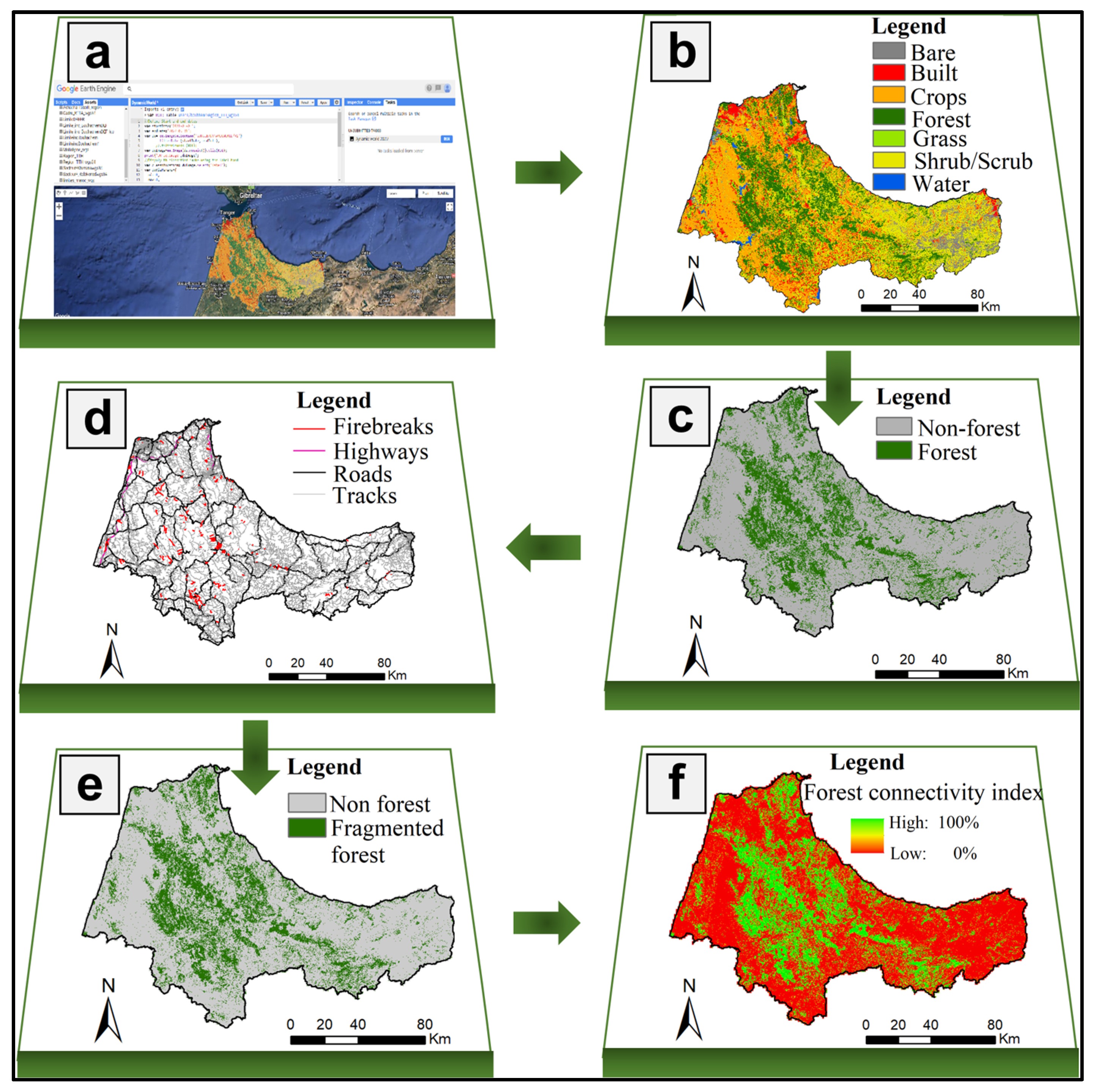
To calculate forest connectivity, we also used DW land cover data. First, we derived a binary map of forest and non-forest pixels (forest = 1 and non-forest = 0). Then, we extracted firebreaks and road network data (highways, roads, tracks) from this map by applying an appropriate buffer width to each layer type (firebreaks: 30 m, highways: 22 m, roads: 10 m, and tracks: 4 m). We noted that firebreaks were digitized from Google Earth Pro software, while the road network data were readily available on the OpenStreetMap (OSM) platform and were downloaded with the BBBIKE web-based tool (https://extract.bbbike.org/, accessed on 25 February 2023). Finally, the forest connectivity index was calculated using SAGA Fragmentation (Standard) module in QGIS by the following equation [40]:
P f f = D f f D f
where (Pff) is the forest connectivity index calculated by dividing the pixel pair number that includes at least one forest pixel (Dff) by the pixel pair number that includes two forest pixels in cardinal directions (Df). The different steps of land use mapping and calculation of the forest connectivity index in the TTA region are summarized in Figure 2.

2.5.3. Identifying Wildfire Strategic Responses

  • Mapping wildfire homogeneous zones
Understanding the specificities of wildfires, including the analysis of potential risk factors and major causes, helps to better orient strategic choices and decisions for fire prevention and control. In the north of Morocco, even if a large part of the fires is reported due to unknown causes, it is possible to affirm that the human factor remains the main cause. In fact, the information collected on the occasion of several fire events evokes causes related to human activities in an accidental or intentional way (land clearing to gain new areas for cultivation, traditional practices, such as honey extraction, landfill, high tension line, vandalism, etc.) [3]. Considering these elements, our study’s methodology suggests a novel approach tailored to our circumstances, which involves utilizing data from burned areas and two active fire sources, namely, the Fire_CCI51 and FIRMS products. Consequently, overlaying the results of the OHA performed using these two types of data on a gridded scale (1 km × 1 km) allowed us to delineate and map similar wildfire zones. The objective is to delineate relatively homogeneous areas with similar fire characteristics (wildfire history, potential causes, and damage caused), to which the identified strategic response categories will be assigned.
  • Defining response categories
In wildfire planning and management, aspired idea through the identification and categorization of strategic responses is to assess the relevance and effectiveness of the choices and policies adopted. In practice, strategic response categories may vary depending on the specific planning context, and spatial response zones may also be updated over time as circumstances change [27]. In the TTA region, taking into account both the specificities and characteristics of the fires, their management conditions, and the results of the response zone mapping (elements outlined in the previous sections), we have identified 3 general response categories:
a-.
Maintain: Includes areas protected from fire; measures adopted so far must be maintained;
b-.
Reinforce: Includes areas not fully protected against fire; measures adopted so far must be reinforced;
c-.
Monitor and raise awareness: Includes areas not fully protected with a high risk of fire outbreaks where priority must be given to monitoring and public awareness actions.
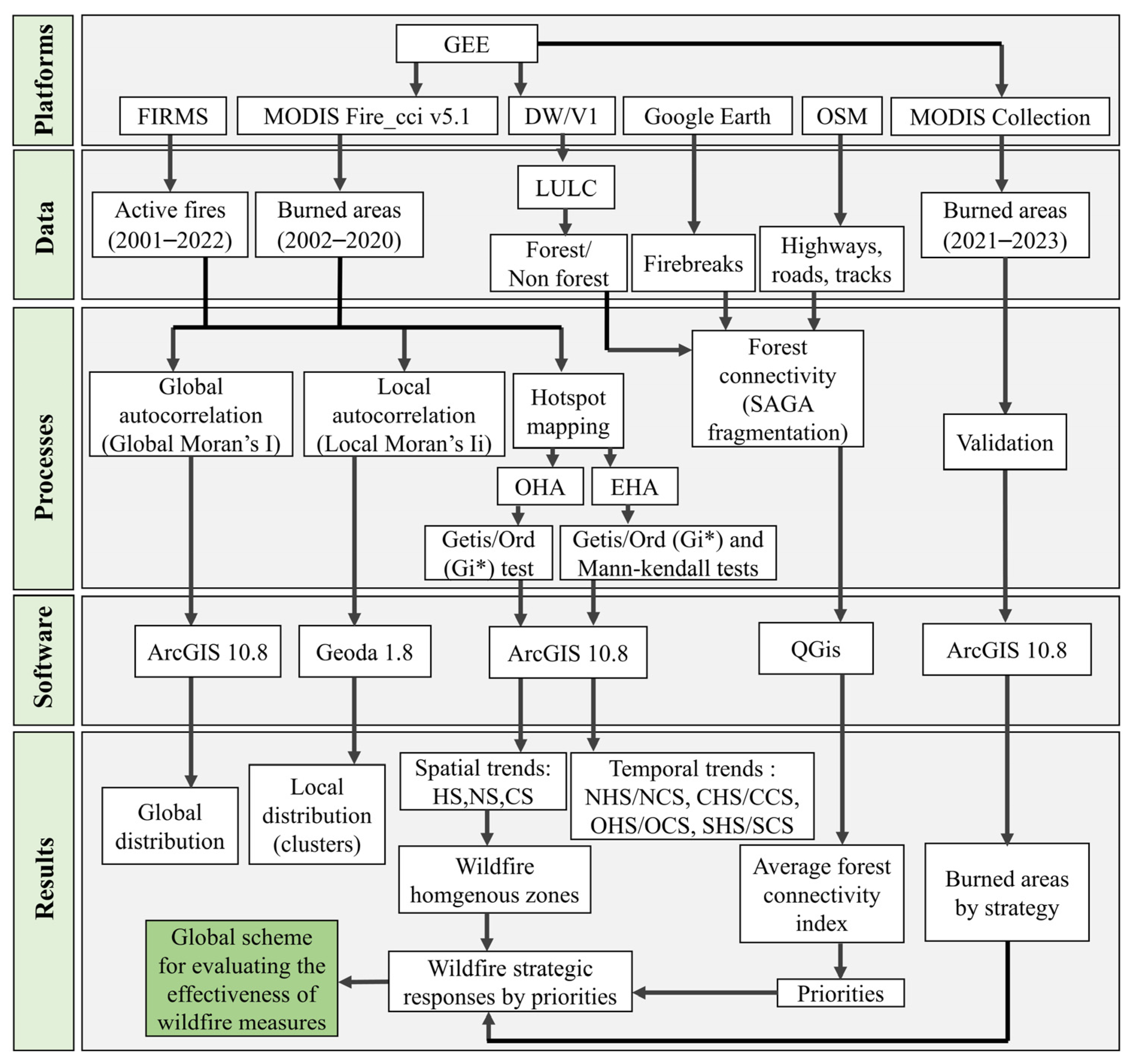
In addition, to ensure a better allocation of human and financial resources during any wildfire programming actions, we found it very useful to prioritize the identified strategic response categories. For this purpose and based on the observation that forest areas with high connectivity present a greater risk of fire propagation and consequently greater potential damage, the average connectivity index calculated in each grid (1 km × 1 km) was adopted as a classification criterion. Hence, four priority classes (low, medium, high, and very high) were defined for equal intervals of the average connectivity index (0% to 25%, 25% to 50%, 50% to 75%, and 75% to 100%). A JavaScript code was developed to extract burned areas in the region for the period (2021–2023) from (MODIS/006/MCD64A1) collection in order to validate the identified strategic responses. Last, a global scheme to assess the effectiveness of wildfire measures was developed. Figure 3 summarizes the complete methodological process undertaken in our study.

3. Results

3.1. Wildfire Statistics

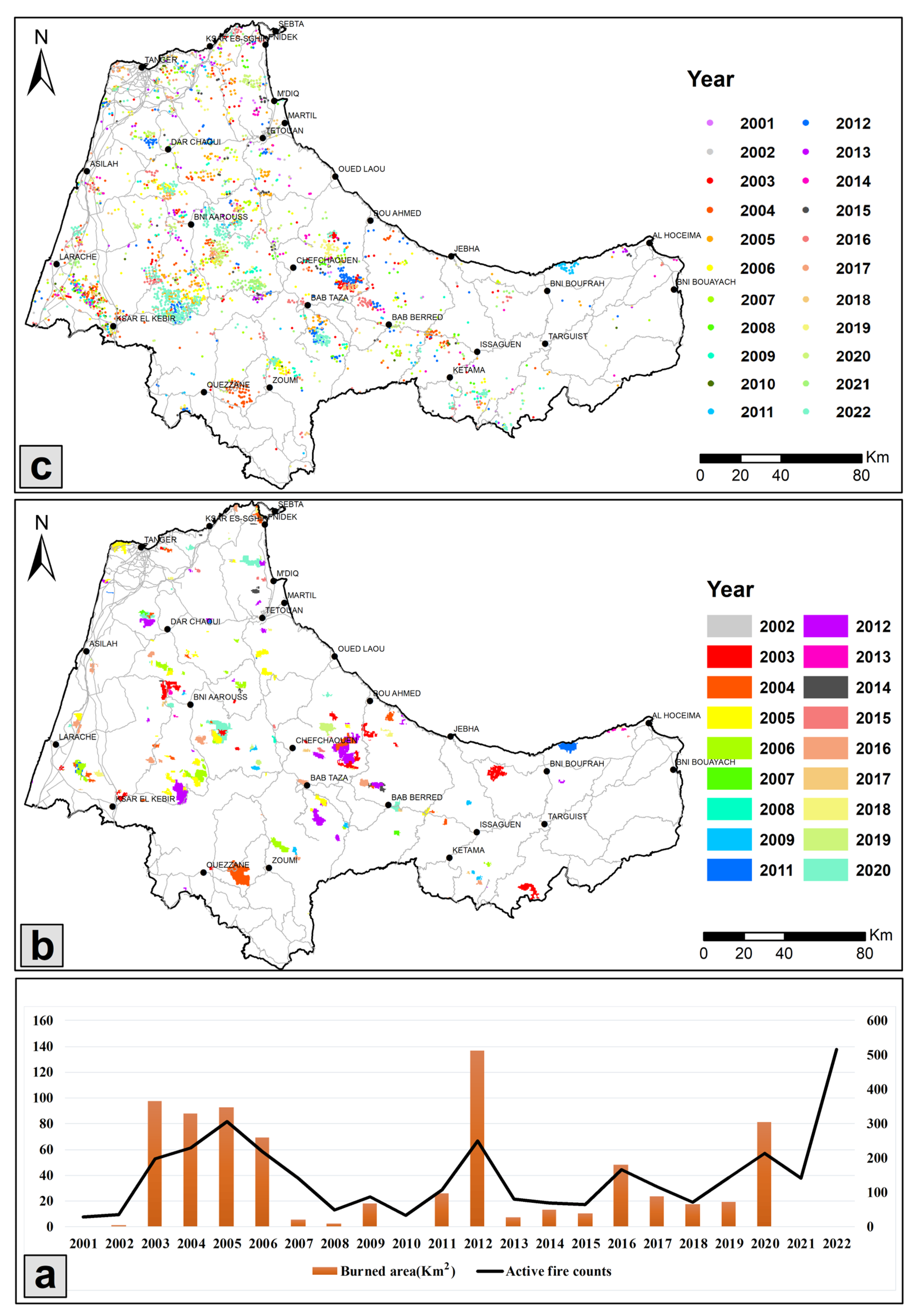
The investigation into the temporal and spatial distribution of burned areas revealed that from 2002 to 2020, the TTA region witnessed a cumulative burned area of 755.74 km2 (translating to an average annual area of 39.78 km2/year). The highest value of the burned area, reaching 136.82 km2, was observed in 2012, whereas no burned areas were recorded in 2010. Furthermore, the yearly burned area distribution was uneven, with the TTA region accounting for the largest burned area (46% of the total study period) only between 2003 and 2006. Moreover, we observed that the eight administrative units of the region were affected by fires to varying degrees. The provinces of Chefchaouen and Larache alone contributed 63% of the total burned area with values of 281.88 and 197.87 km2, respectively (Table 3; Figure 4a,b).
Additionally, throughout the period from 2001 to 2022, the TTA region experienced a total of 3283 active fires, equating to an average of 149 occurrences per year. The highest number of active fires was recorded in 2022 with 516 occurrences, while the lowest was 30 occurrences in 2001. The distribution of active fires across the years is irregular, but there is a notable upward trend toward 2022. Examining the distribution across the eight administrative units, we found that the provinces of Larache and Chefchaouen accounted for 59% of the total number of active fires in the region, with respective values of 1067 and 854 (Table 3; Figure 4a,c).

3.2. Forest Fires Statistics

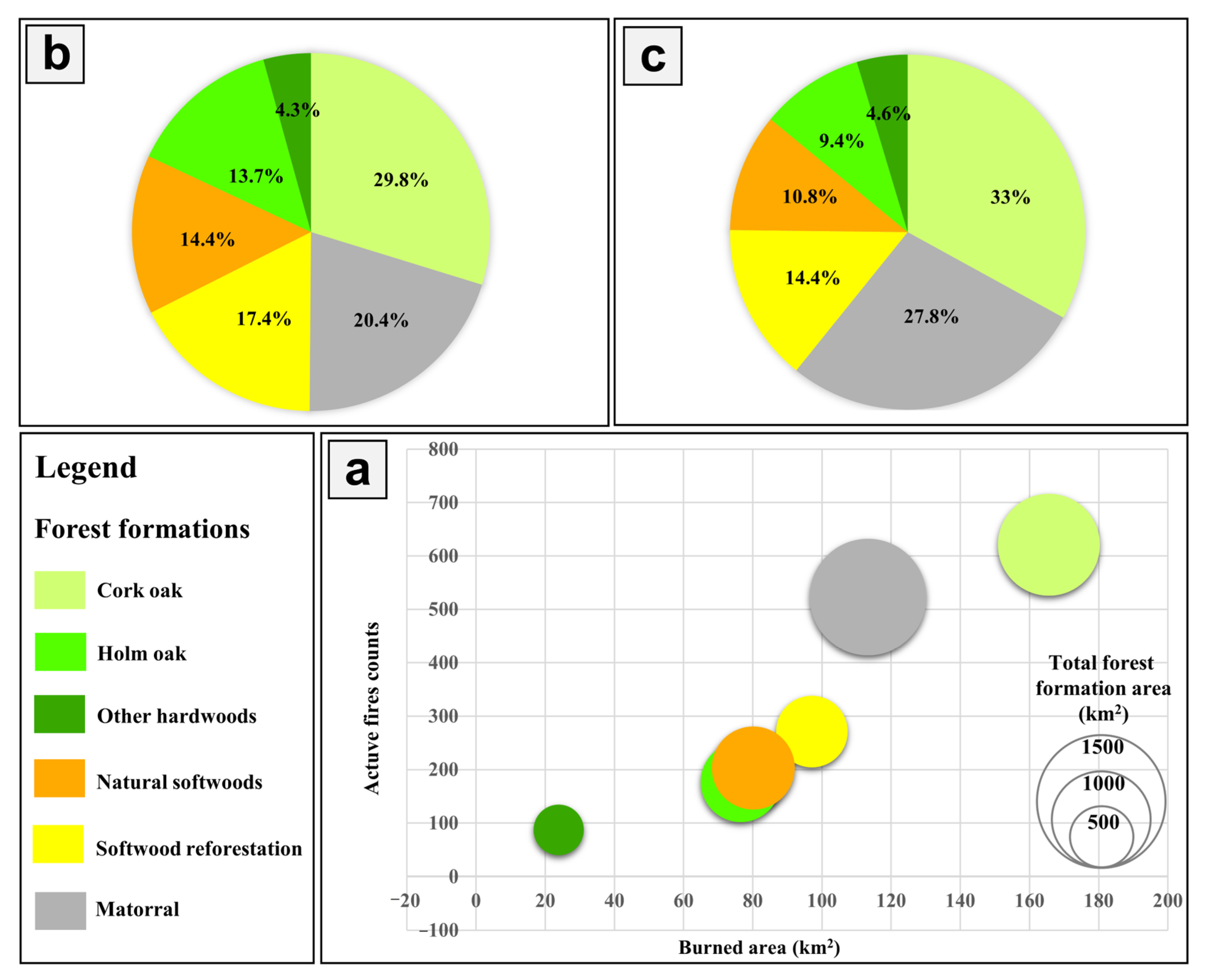
Forest fire statistics according to the type of formation were determined by overlapping Fire_CCI51 and FIRMS data with NFI layers. Our analysis shows that 74% of the burned areas are in forests, representing 556.54 km2 and an average of 29.29 km2/year. Additionally, 57% of active fires occurred in forest formations, totaling 1882 fires and an annual average of 86 fires/year. Figure 5a displays a bubble diagram of the burned areas and active fire counts in different forest formations, considering their total areas. The results show that the largest forest formations (>100 km2) are most susceptible to fire damage. Cork oak stands and matorral formations were the most severely affected with the highest burned areas (165.65 and 113.32 km2, respectively) and the greatest number of active fires (621 and 523, respectively), accounting for 50% of the total burned area and 61% of the total number of active fires (Figure 5b,c). Softwood forests, mainly artificial pine forests, despite having smaller total areas, had a significant burned area and active fire count, evaluated at 97.07 km2 and 271 fires, respectively (i.e., respective percentages of 17% and 14%). Natural softwoods and holm oak had very similar records, with a total area (<1000 km2) and similar burned areas (80.16 and 76.51 km2, respectively) and a respective number of active fires of 203 and 177. These two formations make up about 14% and 10% of the total balance of burned areas and active fires number, respectively. The other hardwoods, with the lowest total area (< 500 km2), had the lowest fire records (area burned of 23.87 km2 and 87 active fires) (Figure 5a).

3.3. Spatial Autocorrelation Analysis

Global spatial autocorrelation of burned areas and the number of active fires for the periods (2002–2020) and (2001–2022), respectively, was conducted to test the degree to which these two variables are spatially autocorrelated in 166 territorial communes using Moran’s I coefficient. In addition, this global index was decomposed by calculating the local Moran’s I index to reveal the existence of possible local significant clusters at the communal level.
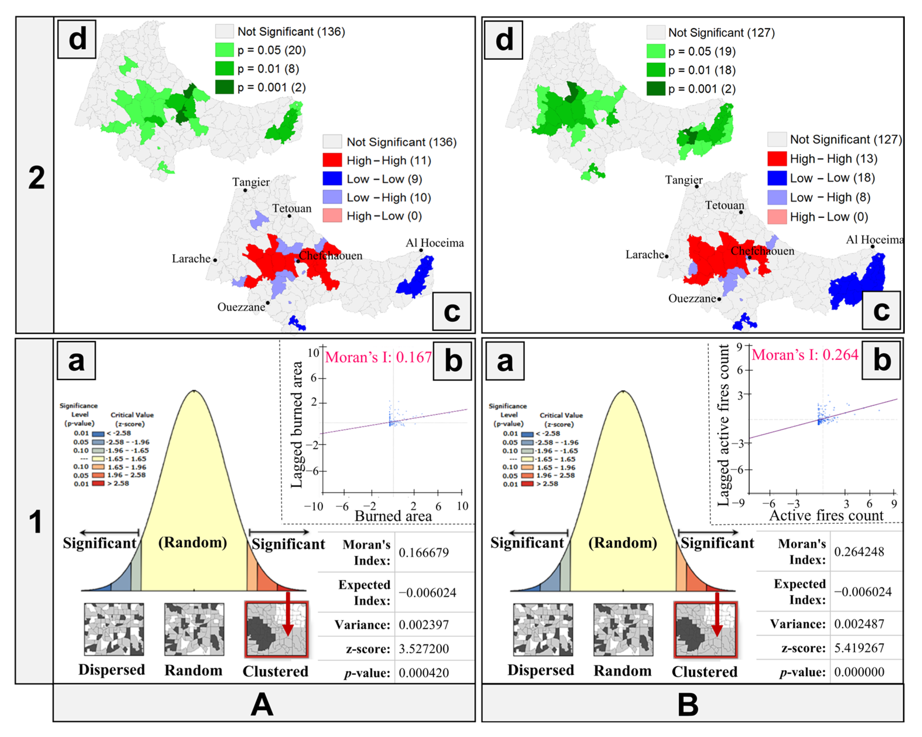
Figure 6(A.1,B.1) shows the results of global spatial autocorrelation of the burned area and active fire count at the commune level during entire study periods. Our findings revealed a positive spatial autocorrelation at the 1% significance level for both variables, as indicated by their respective global Moran’s I values of 0.17 and 0.26 and p-values ≤ 1% (Figure 6(A.1.a,B.1.a)). This result suggests that the distribution of these two variables at the commune level is naturally clustered over the entire periods, meaning that communes with relatively high or low variable values are closer to other communes with similar values than if their localization were random. We also observed that active fires were more aggregated than burned areas, as evidenced by their higher Moran index. The Moran scatter plots shown in Figure 6(A.1.b,B.1.b) visually confirm the positive autocorrelation, with most points representing communes located in the first and fourth quadrants of the plots. The slopes of the lines in the diagrams represent the values of Moran’s I index.
Figure 6(A.2,B.2) display local spatial autocorrelation results for burned areas and active fire counts in the territorial communes of the TTA region. We have observed that around 12% of the communes are characterized by the presence of similar values of burned areas. The HH-type units whose total number is 11 are distributed between the two provinces of Chefchaouen and Larache (7 and 4, respectively), and the LL-type units, whose total number is 9, are located in the provinces of Al Hoceima and Ouezzane (8 and 1, respectively) (Figure 6(A.2.c)). In addition, we have concluded that around 19% of the communes are characterized by the presence of similar values of the active fire count. The HH-type units, whose total number is 13, are distributed between the provinces of Larache, Chefchaouen, and Tetouan (7, 4, and 2, respectively), and the LL-type units, whose total number is 18, are located in the provinces of Al Hoceima and Ouezzane (16 and 2, respectively) (Figure 6(B.2.c)). Maps illustrating the statistical significance levels for the identified clusters are presented in Figure 6(A.2.d,B.2.d). These findings provide insights into the localized patterns of burned areas and active fire counts in the TTA region and have important implications for wildfire management and prevention strategies in this area.

3.4. Hotspot Mapping

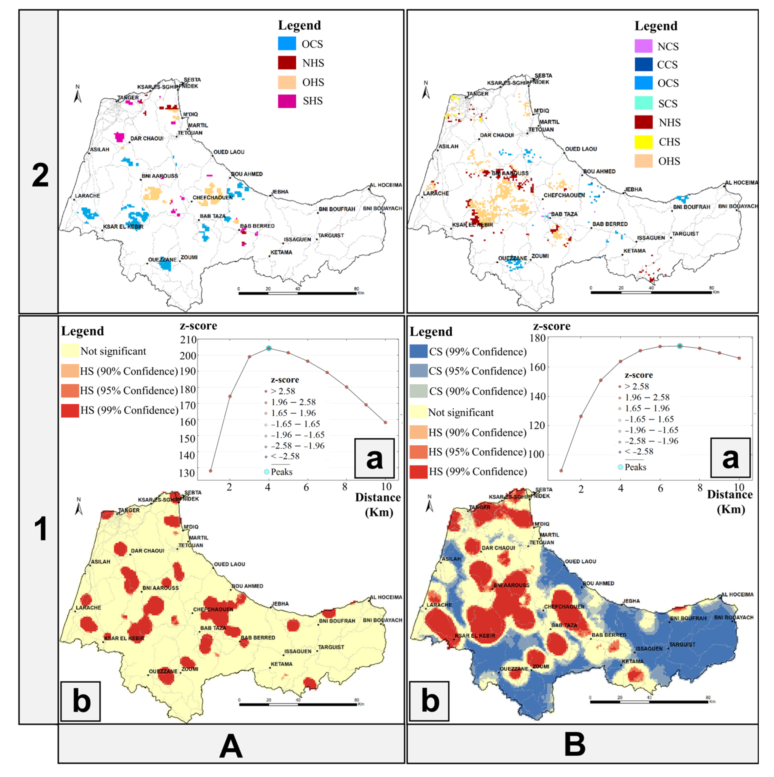
To identify fire hotspots in the region and characterize their spatiotemporal trends, hotspot mapping based on OHA and EHA was carried out using a 1 km × 1 km grid. Results from the incremental spatial autocorrelation tool indicated that the OHA detected the maximum number of clusters at distances of 4 and 7 km for burned areas and active fires, respectively (Figure 7(A.1.a,B.1.a)). The HS of burned areas mainly comprised the highly significant category (significance level = 99%), covering 12.88% of the total area (2081.05 km2), with the remaining cells (87.12%) classified as NS. Most of the detected HS (63%) were located in the provinces of Chefchaouen and Larache (Table 4 and Figure 7(A.1.b)). Additionally, 44.85% and 24.16% of cells represented CS and HS of active fires, respectively (i.e., respective areas of 7246.06 km2 and 3903.55 km2), both predominantly composed of the highly significant category. The largest share of HS (60%) was located in the provinces of Chefchaouen and Larache, while the largest share of CS (80%) was concentrated in the provinces of Al Hoceima, Chefchaouen, and Ouezzane (Table 5 and Figure 7(B.1.b)). The study also noted that about half of the detected HS for both variables occurred in forests, mainly on cork oak stands and mattoral. These two formations alone accounted for 53% and 67% of the burned area and active fire HS reported in forests, respectively.
The EHA method identified eight cluster categories comprising HS and CS, including NHS/NCS, CHS/CCS, OHS/OCS, and SHS/SCS. For burned areas, the identified clusters cover a total area of 740 km2, dominated by two models: OCS (50.23%) and OHS (29.96%). These models are primarily concentrated in the provinces of Chefchaouen and Larache (Table 4 and Figure 7(A.2)). Regarding active fires, the detected clusters cover a total area of 941 km2, mostly distributed between two models: OHS (56.87%) concentrated in the provinces of Larache and Chefchaouen, NHS (24.92%) concentrated in the Larache Province, and OCS (13.93%) distributed among the provinces of Ouezzane, Chfchaouen, Tetouan, and Al Hoceima (Table 5 and Figure 7(B.2)).

3.5. Wildfire Strategic Responses

3.5.1. Mapping Wildfire Homogeneous Zones

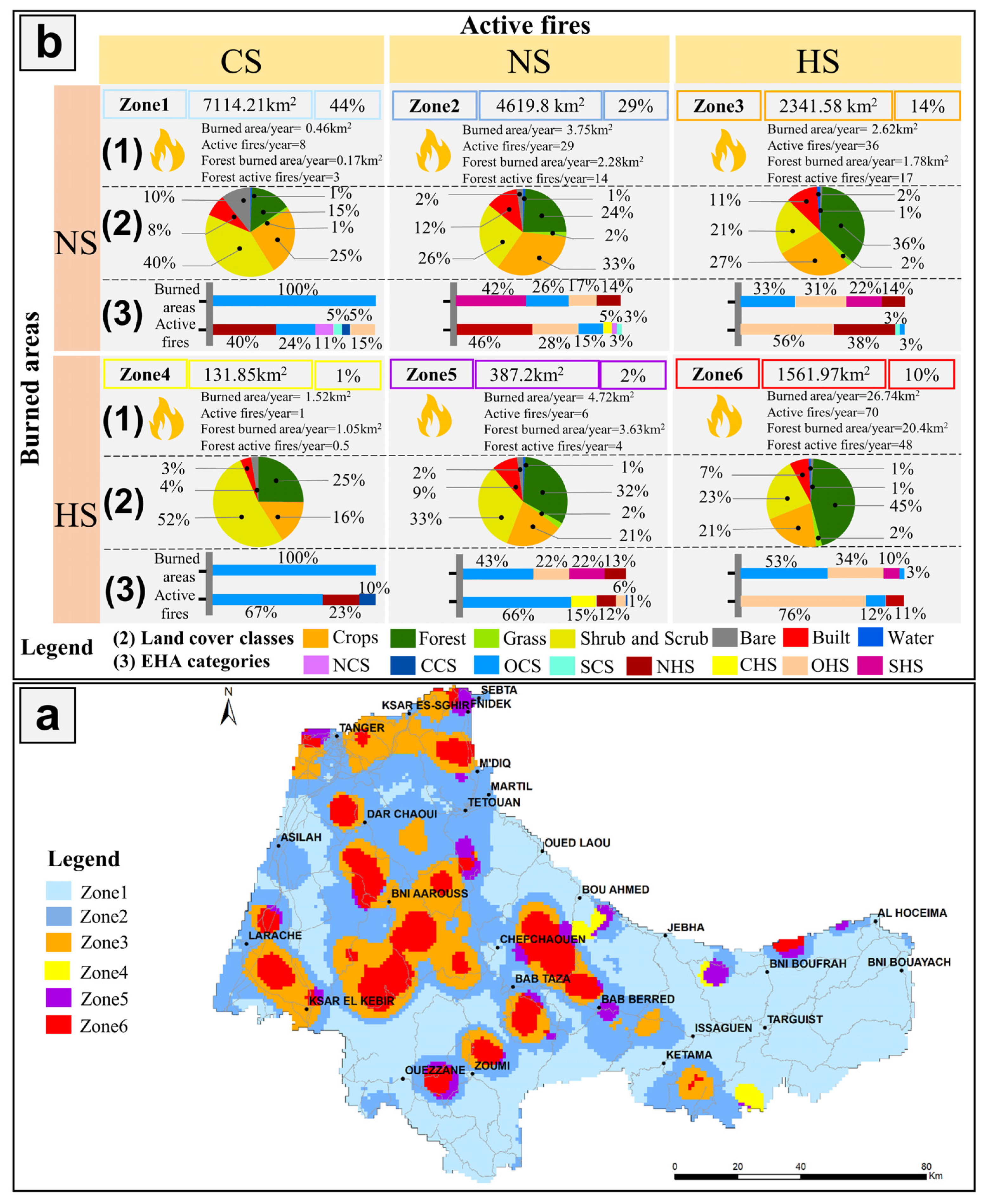
Our study area yielded six wildfire homogeneous zones, which were identified by applying the OHA to burned areas and active fires. These zones were found to be similar in terms of wildfire history, potential causes, and damage caused. However, their spatial distribution varied across the provinces and prefectures of the region, as depicted in Figure 8a. Further insight into these zones was obtained by incorporating data from Fire_CCI51, FIRMS, DW land cover, and the results of the EHA, as demonstrated in Figure 8b:
  • Zone 1:
Covers 44% of the region, with a total area of 7114.21 km2. It corresponds to the NS cells of burned areas and CS cells of active fires and is mainly located in the provinces of Al Hoceima, Ouezzane, and northern parts of Chefchaouen. This zone consists mostly of crop and grasslands (65%) and has very low annual burned and active fire areas (0.46 km2 and 8 fires, respectively). The dominant patterns according to the EHA are OCS for burned areas and NHS for active fires.
  • Zone 2:
Corresponds to the NS cells of both burned areas and active fires and covers 29% of the territory (i.e., a total area of 4619.8 km2). It is found in the different provinces and prefectures and is also composed mostly of crops and grasslands (59%). Annually, it records an average burned area of 3.75 km2 and 29 active fires. The EHA dominant patterns are SHS for burned areas and NHS for active fires.
  • Zone 3:
Results from the combination of burned areas NS cells and active fire HS cells and occupies 14% of the region, with a total area of 2341.58 km2. This zone consists mostly of forest and croplands (63%), and it records a significant number of active fires annually (36 fires/year), half of which are reported in forests. The forest burned areas in this zone amount to 1.78 km2/year with an average of 17 fires/year. The dominant patterns according to the EHA are OCS and OHS for burned areas and OHS for active fires.
  • Zone 4:
Is the smallest zone, covering only 1% of the territory. It corresponds to the coincidence of burned area HS cells and active fire CS cells and is mainly composed of shrub- and scrublands and forests (77%). It is individualized in the form of clusters in the northern and northeastern parts of Chefchaouen Province and the south of Al Hoceima Province. This zone recorded the lowest annual number of active fires (0.5 fire/year), and the burned area is estimated at 1.52 km2/year. The dominant EHA pattern is OCS for the two variables.
  • Zone 5:
Accounting for only 2% of the region, it corresponds to the HS cells of burned areas and NS cells of active fires. Clusters of this zone are located in the different provinces and prefectures and are mostly formed by shrub- and scrublands and forests (65%). Annually, Zone 5 recorded an estimated burned area of 4.72 km2 and six active fires. OCS is the EHA dominant model for the two variables.
  • Zone 6:
Corresponds to the HS cells of both burned areas and active fires and covers 10% of the territory, equivalent to a total area of 1561.97 km2. This zone has the highest annual averages in the region, with 26.74 km2 of burned area per year and 70 active fires per year. In addition, we observed that forests that occupy 45% of Zone 6 concentrate most of the fire statistics (burned area of 20.4 km2/year and 48 active fires/year). The EHA dominant models are OCS for burned areas and OHS for active fires.

3.5.2. Strategic Response Categories

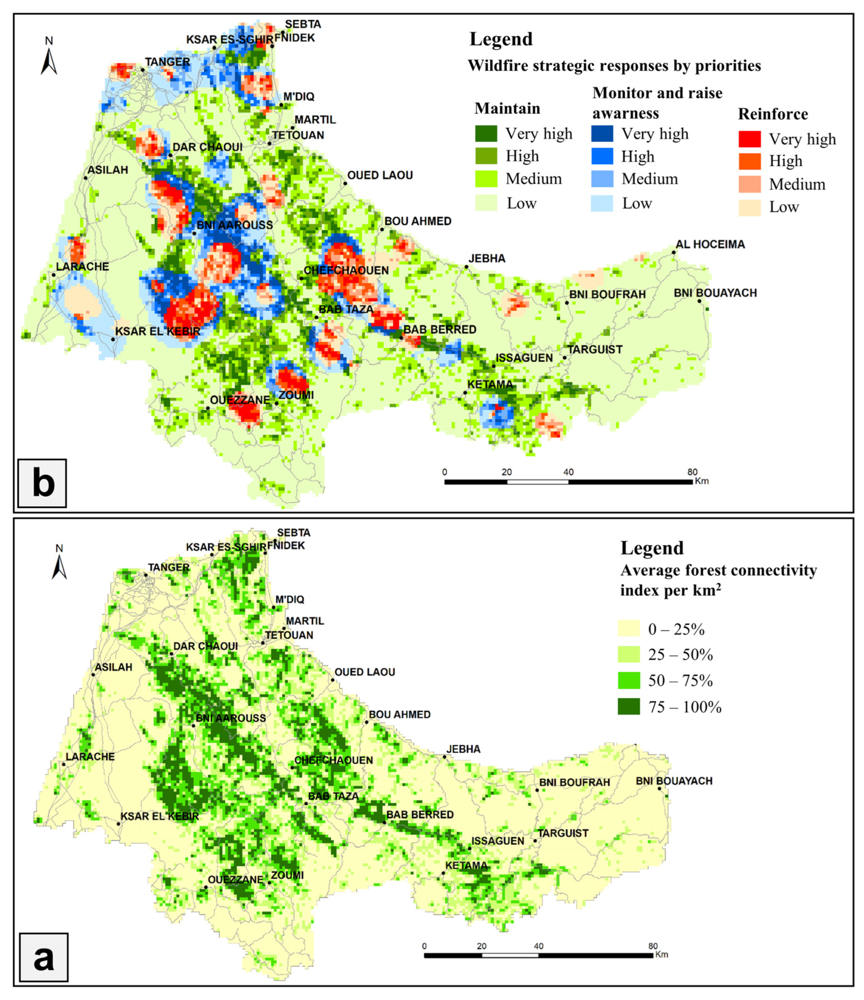
Forest connectivity analysis based on the average forest connectivity index calculated on a gridded scale (1 km × 1 km) showed that for a total number of 16,664 cells in the TTA region, 61% have low forest connectivity. Cells with medium forest connectivity constitute 18%, while those with high and very high forest connectivity occupy 12% and 9%, respectively. Figure 9a displays the spatial distribution of cells according to their average forest connectivity index used as criteria for identifying strategic response priority levels.
In our study, the zones that recorded significant damage in terms of burned areas were considered units not fully protected against fires and requiring reinforcement of protective measures. Thus, these units are composed of the HS-type cells of burned areas and correspond to the grouping of Zones 4, 5, and 6 to which the strategy to be assigned is “reinforce”. Conversely, given that Zones 1 and 2 correspond to the combination of burned area NS cells on the one hand and CS or NS cells of active fires on the other, they were considered a group weakly affected by fires and protected against wildfires. Consequently, the measures taken in this group were considered sufficient, and the strategy to be adopted in this case was “maintain”. Finally, although Zone 3 is also composed of burned area NS cells, it corresponds to active fire HS and is therefore considered not fully protected against fires. However, this zone requires a specific strategy aimed at reducing the number of fire outbreaks called “monitor and raise awareness”.
Figure 9b and Table 6 display, respectively, the spatial distribution and statistics of the three strategic responses by priority in the various provinces and prefectures of the region. Based on our analysis, we found that the largest area of the region, estimated at 11,734 km2 (or 73%), requires a “maintain” strategy. An area of 2341.6 km2 (or 14%) is assigned to the “monitor and raise awareness” strategy, while the “reinforce” strategy concerns an area of 2081 km2 (or 13%). Due to the prevalence of low forest connectivity in many cells, we observed a dominance of the low priority level for all three strategies. Nonetheless, a significant proportion of each strategy falls under the remaining priority levels (medium, high, and very high), comprising 28% of the “maintain” strategy, 56.6% of the “monitor and raise awareness” strategy and 62.8% of the “reinforce” strategy. When looking at the administrative units, we found that the provinces of Chefchaouen and Ouezzane account for 51% of the “maintain” strategy territory, while the provinces of Larache and Chefchaouen, respectively, hold 55% and 63% of the “monitor and raise awareness” and “reinforce” strategies.

4. Discussions

4.1. Wildfires Statistics

The study of fire history over about 2 decades in the TTA region revealed a total burned area of 755.74 km2 and 3283 active fires, with an average of 39.78 km2/year and 149 fires/year. The analysis of annual fire statistics showed an irregular trend. In fact, the years 2003–2006, 2012, and 2020 were exceptional and recorded the highest values of the study period. These increases can mainly be explained by population behaviors after regional or international events (fighting fellow cannabis culture, COVID-19 pandemic). Spatially, the provinces of Chefchaouen and Larache had the largest fire statistics in the region, accounting for 63% of the burned area and 59% of the number of fires. These two provinces are the most affected by fires, on the one hand, because of the large areas of the forest they have individualized by vast massifs, and on the other hand, due to the high pressures from local populations on land resulting from the use of fire as a clearing land practice for cultivation [41].
Our analysis demonstrated that forests were the site of 74% of the burned areas and 57% of active fires, with an annual average of 29.29 km2/year and 86 fires/year. Comparing these numbers to the Fire_CCI51 and FIRMS data for Morocco indicated that this region alone accounts for a substantial proportion of the country’s forests burned areas and active fires (about 61% and 60%, respectively), underscoring the TTA region’s status as Morocco’s primary region in terms of forest fires. This outcome can be mainly attributed to the region’s special biophysical features, including the presence of highly combustible forest species on rough terrain and to the local practice of using fires to clear land for agriculture [3]. In relation to forest formations, it was observed that the cork oak and matorral are the formations most impacted by fires, with 50% of the burned areas and 61% of active fires reported in forests. This can be attributed to the large areas covered by these formations in the region, as well as the continuous pressures exerted by local populations seeking to expand their living space through activities such as cultivation, grazing, and wood collection, which often involve clearing and burning in these stands [38,42]. Softwood reforestation, primarily consisting of Aleppo pine, maritime pine, and brutia pine, also accounts for a significant portion of the regional fire balance, representing 17% and 14% of burned areas and active fires, respectively. This finding is not surprising, given the high flammability of these formations, despite their relatively small area.

4.2. Spatial Autocorrelation Analysis

Analysis of global spatial autocorrelation at the communal level (166 territorial communes) revealed relatively low positive Moran’s I values for burned areas and active fires (0.17 and 0.26, respectively), indicating relatively low spatial aggregation for these two variables. Furthermore, we observed that the spatial structure of active fires tended to be more clustered than that of the burned areas. A local disaggregation of the global coefficient using the local Moran index revealed the presence of 13 local communes (7.8% of the total number) characterized by high fire activity (HH type), dispersed across the provinces of Chefchaouen and Larache. This finding corroborates the results of wildfire statistics by province, but above all, provides valuable information to better target territorial communes requiring special attention on wildfire fighting programs. In addition, 16 territorial communes (9.6% of the total number) were reported as low fire activity spatial units (LL type) shared between the provinces of Al Hoceima and Ouezzane, while the remaining communes (82.6%) consisted mainly of insignificant units, with a small share of (LH) units.

4.3. Hotspot Mapping

By integrating two statistical methods (OHA and EHA), hotspot mapping provided even more pertinent results at a finer spatiotemporal dimension (1 km2 grid, 1-year time interval). Globally, HS of burned areas and active fires cover, respectively, 12.88% and 24.16% of the territory (i.e., respective areas of 2081.05 and 3903.55 km2) and were primarily composed of very highly significant categories. Spatially, these HS are distributed among the provinces/prefectures and the forest formations in varying shares. Indeed, we observed once again that the provinces of Chefchaouen and Larache had the largest shares: 63% and 60%, respectively, for burned area and active fire HS. Furthermore, about half of HS are located in forest formations (mainly in cork oak stands and mattoral). Aside from negative ecological impacts on soil, air, and biodiversity, forest fires are closely associated with forest cover regression and are even considered to be the major precursor to deforestation in the TTA region [43]. In this sense, it is reported that the western Rif records gross annual forest losses of 13.62 km2 mainly due to fires, with also significant deforestation shares in the provinces of Chefchaouen and Larache (4.1 and 2.7 km2/year, respectively) and about 55% of the total losses recorded in cork and mattoral stands [5].
The wildfire pattern in our study area was outlined by EHA, which identified two dominant models for each variable. Burned area clusters covered 740 km2 and were primarily made up of OCS (50.23%) and OHS (29.96%) patterns, while active fire clusters occupied 941 km2 and were mainly formed by OHS (56.87%) and NHS (24.92%) patterns. OHS/OCS represents locations with statistically significant HS/CS for the final time-step interval, which were statistically significant CS/HS during a previous time step, and less than 90% of the time steps were statistically significant HS/CS. While NHS represents statistically significant HS locations only during the last time step that have never been statistically significant HS before. The dominance of the OHS and OCS models for the two variables under study can be explained by the large variations in wildfire activity experienced in the area during the study periods, alternating between periods of high and low wildfire activity. Furthermore, the significant increase in active fires in recent years has led to the emergence of new HS, resulting in an important proportion of active fires in NHS models. These wildfire trends have been discussed in previous sections.

4.4. Wildfire Strategic Responses

In our research, we defined six homogeneous wildfire zones through the combined use of nearly two decades’ data on burned areas and active fires and processed them through an OHA. Zones 1 and 2, corresponding to the combination of burned area NS cells and active fire CS and NS cells, respectively, were considered fire-protected areas. Over the years, efforts made in these zones, including prevention, risk analysis, preparation, intervention, and rehabilitation measures, contributed significantly to their preservation against fires. Thus, the future challenge is to maintain these measures to keep these areas protected, that is why we have opted for a “maintain” strategy in this case. We concluded that the territory concerned by this category covers the largest portion of the region (73%), which testifies to the important efforts made in this direction. We also found that the provinces of Chefchaouen and Ouezzane alone account for 51% of the “maintain” strategy territory. In this case, we can note that programs implemented after the large fires experienced by the two provinces between 2003 and 2006 explain how these actions contributed to the future preservation of many areas.
In addition, Zones 4, 5, and 6 covering 13% of the territory of the region and corresponding to burned area HS were considered not totally protected against fires. These zones, where the dominant land cover is forests (≥25%), are highly affected by fires and require a “reinforce” strategy in the future. Zone 3 consists of the combination of burned area NS cells and active fire HS cells and covers 14% of the total area. Given the high number of fires recorded in this zone, it still presents a major risk of fires, especially since it is mainly occupied by forests (36%). Subsequently, the future challenge for this zone is to “monitor and raise awareness” in order to reduce the number of fires. Since the provinces of Chefchaouen and Larache are experiencing the most important fire activities in the region, particularly in recent years, we found that these two provinces require the implementation of the “reinforce” and “monitor and raise awareness” strategies by 63% and 55%, respectively.
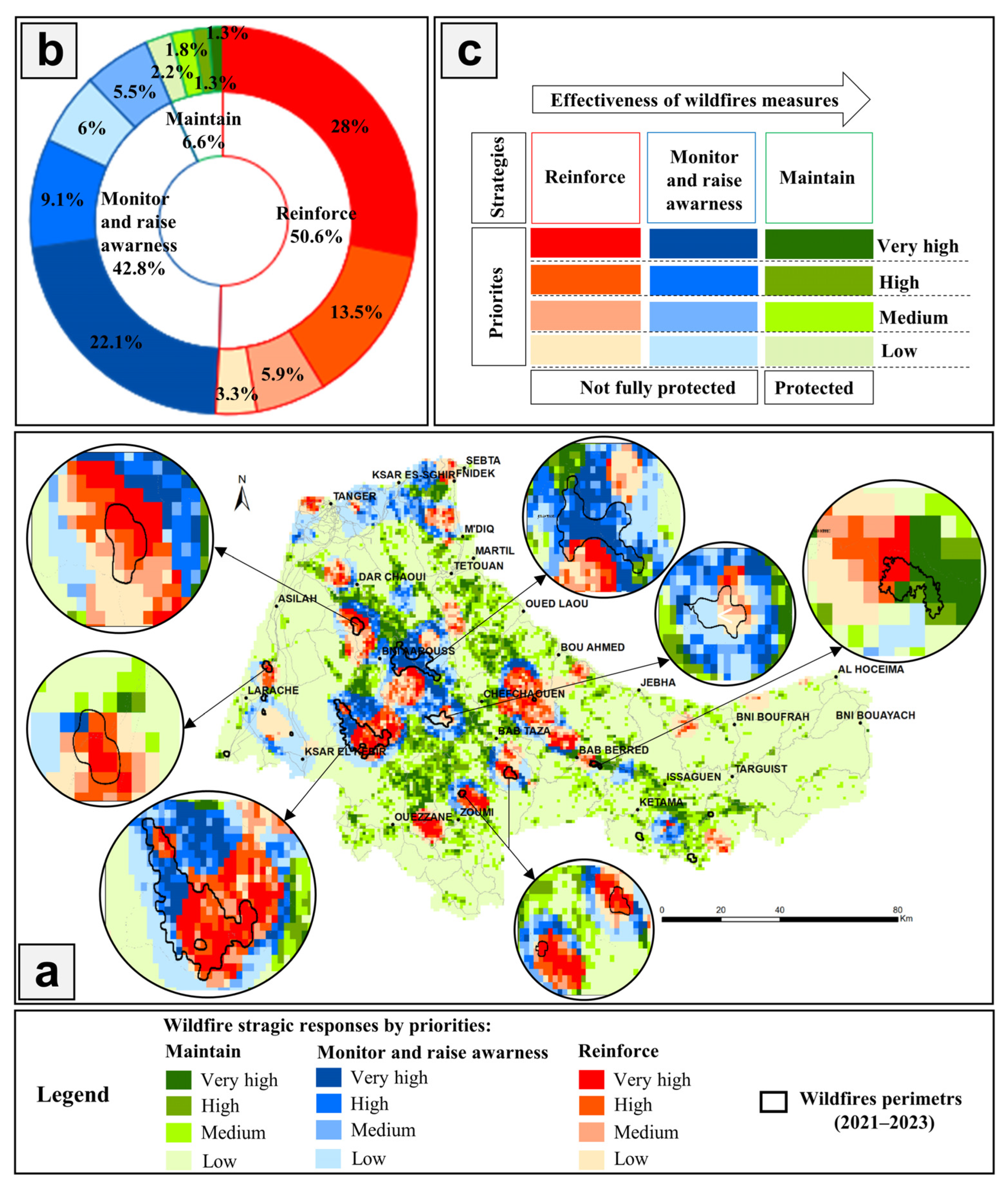
To validate the zoning and wildfire strategic responses, we projected the fires that occurred in the region between 2021 and 2023, which are not available in the Fire_CCI51 version (Figure 10a). We found that the burned area during this period was 304.17 km2, and 93.4% of it was located in the territories of the “reinforce” and “monitor and raise awareness” strategies (with shares of 50.6% and 42.8%, respectively). Additionally, we observed that burned areas predominate at very high and high priority levels among these two strategies, indicating the need for urgent intervention in these units to better protect against fires (Figure 10b). We point out that the share of fires found in the territory of the “maintain” strategy is very low (6.6%), and it could even be largely attributed to spreads from areas that are not fully protected.
In conjunction with several types of research conducted globally, our study showcases the paramount importance of spatial wildfire risk assessment in augmenting comprehension of the potential threats posed by wildfires and devising efficacious strategies to alleviate their impacts. The process of zoning, which classifies areas according to their susceptibility to wildfires, enables communities and authorities to allocate resources more judiciously and implement customized measures to mitigate risks. Notably, a study conducted by Thompson et al. (2016) in California adhered to the aforementioned framework by identifying three strategic responses to fire (maintain, protect, and restore) and delineating potential wildland fire operational delineations (PODs) as the spatial unit of analysis for strategic responses. This research identified gaps, limitations, and uncertainties, and prioritized future work to support safe and effective incident response [27]. Furthermore, Dunn et al. (2020) proposed a novel approach to risk science that effectively aligns decisions regarding wildfire response, mitigation opportunities, and land management objectives through the conscious integration of social, ecological, and fire management system needs. Their study focused on fire-prone landscapes in the US Pacific Northwest and presents an account of how three complementary risk-based analytic tools—namely, quantitative wildfire risk assessment, mapping of suppression difficulty, and atlases of potential control locations—can serve as the basis for adaptive governance in fire management. These tools enable the integration of wildfire risk with fire management difficulties and opportunities, thereby providing a comprehensive understanding of the wildfire risk management challenge in the region [44].
Finally, Figure 10c shows the global scheme for evaluating the effectiveness of wildfire measures developed in light of our findings. It can be concluded that the measures adopted within spatial units can be considered effective if they enable these units to move from not fully protected areas to protected areas—in other words, if these units slip from “reinforce” and “monitor and raise awareness” strategies to the “maintain” strategy. The total number of spatial units transitioning from not fully protected areas to protected areas and vice versa can be used to assess the global performance of measures taken during a considerable period.

4.5. Limitations

Reconstructing the history of fires is not a simple task, and the complexity increases as the scope and duration of the investigation expand. Furthermore, the insufficiency of comprehensive documentation of fire occurrences in various regions around the globe, coupled with the limitations of official statistical data due to technical or political considerations, renders the use of remotely sensed data an essential requirement in understanding fire regimes [45]. These data have the advantage of being based on a more objective approach, while concurrently presenting more consistency over time and space [46].
In addition, the spatial resolution of MODIS burned area products is relatively low, rendering them more reliable to map medium and large-scale fires. Consequently, some small-scale fires are not included in these products [46,47]. However, it is important to note that the expanse of the study area encompassing an entire region, juxtaposed with the necessity to span a considerable duration for a more comprehensive evaluation of fire hazards, makes the use of these products more relevant. In addition, the combined use of active fires and burned area data in our study balances these limitations and enables the integration of risks linked to minor fires.

5. Conclusions

Wildfires have been a persistent issue in the TTA region, resulting in adverse impacts on ecological, economic, and social dimensions. Over the years, the Moroccan forest authority has taken various measures related to five components: prevention, risk analysis, preparation, intervention, and rehabilitation, contributing to the protection of a considerable territory in our study area. However, in recent times, the rapid socioeconomic growth in the region, coupled with unfavorable global warming conditions, has resulted in an increase in the number and extent of wildfires, making their management and control efforts more challenging and costly.
This study explored the history of fires in the area, reviewed the current wildfire management context, and identified appropriate strategies for the future. The combined use of various spatial remote sensing platforms and different spatial statistical methods provide a valuable supplement to wildfire investigations in the region. In addition to the geospatial analysis results, this work provides a framework for strategic thinking and planning, which suggests useful tools for rationalizing, prioritizing, and guidance of regional programs to monitor and combat wildfires.

Author Contributions

Conceptualization, H.B., A.G. and A.M.; methodology, H.B. and A.G.; software, H.B.; validation, A.M. and M.D.; formal analysis, Y.M. and M.D.; investigation, H.B., A.G. and A.M.; resources, H.B. and A.G.; data curation, Y.M. and M.D.; writing—original draft preparation, H.B. and A.G.; writing—review and editing, H.B., Y.M., A.G., M.D. and A.M.; supervision, A.M., A.G. and M.D. All authors have read and agreed to the published version of the manuscript.

Funding

This research received no external funding.

Institutional Review Board Statement

Not applicable.

Informed Consent Statement

Not applicable.

Data Availability Statement

The data presented in this study are available upon request from the corresponding author.

Acknowledgments

We wish to express our thanks to the Department of Water and Forests of Tetouan for the supervision of this study.

Conflicts of Interest

The authors declare no conflict of interest.

References

  1. Tyukavina, A.; Potapov, P.; Hansen, M.C.; Pickens, A.H.; Stehman, S.V.; Turubanova, S.; Parker, D.; Zalles, V.; Lima, A.; Kommareddy, I.; et al. Global Trends of Forest Loss Due to Fire From 2001 to 2019. Front. Remote Sens. 2022, 3, 825190. [Google Scholar] [CrossRef]
  2. WWF. Fires, Forests and the Future: A Crisis Raging out of Control? 2020. Available online: https://www.readkong.com/page/fires-forests-and-the-future-a-crisis-raging-out-of-6354457 (accessed on 6 January 2023).
  3. Joint Research Centre (European Commission); Schulte, E.; Maianti, P.; Boca, R.; De Rigo, D.; Ferrari, D.; Durrant, T.; Loffler, P.; San-Miguel-Ayanz, J.; Branco, A.; et al. Forest Fires in Europe, Middle East and North Africa 2016; Publications Office of the European Union: Luxembourg, Germany, 2017; Available online: https://data.europa.eu/doi/10.2760/17690 (accessed on 6 January 2023).
  4. Assali, F.; Mharzi Alaoui, H.; Rouchdi, M.; et Badraoui, M. Modelling and mapping forest fire ignition risk in North-West Morocco (Chefchaouen-Ouazzane Region). Rev. Ecol. Terre Vie 2016, 71, 111–128. [Google Scholar]
  5. Boubekraoui, H.; Maouni, Y.; Ghallab, A.; Draoui, M.; Maouni, A. Spatio-Temporal Analysis and Identification of Deforestation Hotspots in the Moroccan Western Rif. Trees For. People 2023, 12, 100388. [Google Scholar] [CrossRef]
  6. Zidane, I.E.; Lhissou, R.; Ismaili, M.; Manyari, Y.; Bouli, A.; Mabrouki, M. Characterization of Fire Severity in the Moroccan Rif Using Landsat-8 and Sentinel-2 Satellite Images. Int. J. Adv. Sci. Eng. Inf. Technol. 2021, 11, 72–83. Available online: http://ijaseit.insightsociety.org/index.php?option=com_content&view=article&id=9&Itemid=1&article_id=10342 (accessed on 8 January 2023). [CrossRef]
  7. Alaoui, H.M.; Assali, F.; Rouchdi, M.; Tahiri, D.; Lahssini, S.; Aafi, A.; Moukrim, S. Mapping of fire intensity and of sensibility to crown fires in Mediterranean forests. Case of the province of Chefchaouen in northern Morocco. Rev. Ecol. 2017, 42, 387–409. [Google Scholar]
  8. Mohajane, M.; Costache, R.; Karimi, F.; Pham, Q.B.; Essahlaoui, A.; Nguyen, H.; Laneve, G.; Oudija, F. Application of remote sensing and machine learning algorithms for forest fire mapping in a Mediterranean area. Ecol. Indic. 2021, 129, 107869. [Google Scholar] [CrossRef]
  9. Champin, L.; Taïbi, A.N.; Ballouche, A. Spatial Analysis of the Occurrence and Spread of Wildfires in Southwest Madagascar. Fire 2022, 5, 98. [Google Scholar] [CrossRef]
  10. Roy, D.P.; Landmann, T. Characterizing the surface heterogeneity of fire effects using multi-temporal reflective wavelength data. Int. J. Remote Sens. 2005, 26, 4197–4218. [Google Scholar] [CrossRef]
  11. Haut-Commissariat au Plan (HCP). Monographie Régionale de Tanger-Tétouan-Al Hoceima. 2020. Available online: https://www.hcp.ma/region-tanger/attachment/2141567/ (accessed on 12 June 2022).
  12. Ministère de l’Energie, des Mines et de l’Environnement-Département de l’environnement (MEME). Elaboration D’un Plan Climat Territorial Pour la Région de Tanger-Tétouan-Al Hoceima; RAPPORT DE LA MISSION 3: Conception et élaboration d’un Plan D’adaptation Prioritaire; MEME: Rabat, Morocco, 2021; 154p. [Google Scholar]
  13. HCEFLCD. Haut-Commissariat aux Eaux et Forêts et à la Lutte Contre la Désertification. In Base de Données Cartographiques de L’inventaire Forestier National, Rapport Interne; Haut-Commissariat Aux Eaux et Forêts et à la Lutte Contre la Désertification: Rabat, Chellah, Quartier Administratif, Morocco, 2004. [Google Scholar]
  14. ANEF. Agence Nationale des Eaux et Forêts. In Incendies des Forêts—Chiffres Clés; Agence Nationale des Eaux et Forêts: Rabat, Chellah, Quartier Administratif, Morocco, 2023. Available online: http://www.eauxetforets.gov.ma/Pages/Incendies-Chiffres-cles.aspx (accessed on 31 January 2023).
  15. Chuvieco, E.; Pettinari, M.L.; Lizundia-Loiola, J.; Storm, T.; Padilla Parellada, M. ESA Fire Climate Change Initiative (Fire_cci): MODIS Fire_cci Burned Area Pixel Product, Version 5.1; Centre for Environmental Data Analysis (CEDA): Chilton, UK, 2018. [Google Scholar] [CrossRef]
  16. ESA. European Space Agency (ESA) Climate Change Initiative (CCI) Programme, Fire ECV FireCCI51: MODIS Fire_cci Burned Area Pixel Product, Version 5.1|Earth Engine Data Catalog. Google Developers. 2018. Available online: https://developers.google.com/earth-engine/datasets/catalog/ESA_CCI_FireCCI_5_1 (accessed on 12 January 2023).
  17. Anselin, L.; Getis, A. Spatial statistical analysis and geographic information systems. Ann. Reg. Sci. 1992, 26, 19–33. [Google Scholar] [CrossRef]
  18. Anselin, L. The Local Indicators of Spatial Association—LISA. Geogr. Anal. 1995, 27, 93–115. [Google Scholar] [CrossRef]
  19. Oliveau, S. Autocorrélation spatiale: Leçons du changement d’échelle. L’Espace Géograph. 2010, 39, 51–64. [Google Scholar] [CrossRef]
  20. Araza, A.B.; Castillo, G.B.; Buduan, E.D.; Hein, L.; Herold, M.; Reiche, J.; Gou, Y.; Villaluz, M.G.Q.; Razal, R.A. Intra-Annual Identification of Local Deforestation Hotspots in the Philippines Using Earth Observation Products. Forests 2021, 12, 1008. [Google Scholar] [CrossRef]
  21. Khan, S.D.; Gadea, O.C.A.; Alvarado, A.T.; Tirmizi, O.A. Surface Deformation Analysis of the Houston Area Using Time Series Interferometry and Emerging Hot Spot Analysis. Remote Sens. 2022, 14, 3831. [Google Scholar] [CrossRef]
  22. Getis, A.; Ord, J.K. The Analysis of Spatial Association by Use of Distance Statistics. Geogr. Anal. 2010, 24, 189–206. [Google Scholar] [CrossRef]
  23. ESRI. Optimized Hot Spot Analysis (Spatial Statistics)—ArcMap|Documentation. 2023. Available online: https://desktop.arcgis.com/fr/arcmap/latest/tools/spatial-statistics-toolbox/optimized-hot-spot-analysis.htm (accessed on 2 February 2023).
  24. Anselin, L.; Rey, S.J. (Eds.) Perspectives on Spatial Data Analysis; Advances in Spatial Science; Springer: Berlin/Heidelberg, Germany; New York, NY, USA, 2010. [Google Scholar] [CrossRef]
  25. Ord, J.K.; Getis, A. Local Spatial Autocorrelation Statistics: Distributional Issues and an Application. Geogr. Anal. 1995, 27, 286–306. [Google Scholar] [CrossRef]
  26. Harris, N.L.; Goldman, E.; Gabris, C.; Nordling, J.; Minnemeyer, S.; Ansari, S.; Lippmann, M.; Bennett, L.; Raad, M.; Hansen, M.; et al. Using spatial statistics to identify emerging hot spots of forest loss. Environ. Res. Lett. 2017, 12, 024012. [Google Scholar] [CrossRef] [Green Version]
  27. Thompson, M.P.; Bowden, P.; Brough, A.; Scott, J.H.; Gilbertson-Day, J.; Taylor, A.; Anderson, J.; Haas, J.R. Application of Wildfire Risk Assessment Results to Wildfire Response Planning in the Southern Sierra Nevada, California, USA. Forests 2016, 7, 64. [Google Scholar] [CrossRef] [Green Version]
  28. Thompson, M.P.; MacGregor, D.G.; Calkin, D. Risk Management: Core Principles and Practices, and Their Relevance to Wildland Fire; RMRS-GTR-350; U.S. Department of Agriculture, Forest Service, Rocky Mountain Research Station: Ft. Collins, CO, USA, 2016. [CrossRef]
  29. Oliveira, S.; Rocha, J.; Sá, A. Wildfire risk modeling. Curr. Opin. Environ. Sci. Health 2021, 23, 100274. [Google Scholar] [CrossRef]
  30. Nur, A.S.; Kim, Y.J.; Lee, J.H.; Lee, C.-W. Spatial Prediction of Wildfire Susceptibility Using Hybrid Machine Learning Models Based on Support Vector Regression in Sydney, Australia. Remote Sens. 2023, 15, 760. [Google Scholar] [CrossRef]
  31. Cao, Y.; Wang, M.; Liu, K. Wildfire Susceptibility Assessment in Southern China: A Comparison of Multiple Methods. Int. J. Disaster Risk Sci. 2017, 8, 164–181. [Google Scholar] [CrossRef] [Green Version]
  32. Ager, A.A.; Palaiologou, P.; Evers, C.R.; Day, M.A.; Ringo, C.; Short, K. Wildfire exposure to the wildland urban interface in the western US. Appl. Geogr. 2019, 111, 102059. [Google Scholar] [CrossRef]
  33. Cáceres, C.F. Using GIS in Hotspots Analysis and for Forest Fire Risk Zones Mapping in the Yeguare Region, Southeastern Honduras. Pap. Resour. Anal. 2011, 13, 1–14. [Google Scholar] [CrossRef]
  34. Dhar, T.; Bhatta, B.; Aravindan, S. Forest fire occurrence, distribution and risk mapping using geoinformation technology: A case study in the sub-tropical forest of the Meghalaya, India. Remote. Sens. Appl. Soc. Environ. 2023, 29, 100883. [Google Scholar] [CrossRef]
  35. ANEF. Agence Nationale des Eaux et Forêts. In Incendies des Forêts—Stratégie de Gestion; Agence Nationale des Eaux et Forêts: Rabat, Chellah, Quartier Administratif, Morocco, 2023. Available online: http://www.eauxetforets.gov.ma/Pages/Incendies-strategie-de-gestion.aspx (accessed on 7 February 2023).
  36. Chebli, Y.; Chentouf, M.; Ozer, P.; Hornick, J.-L.; Cabaraux, J.-F. Forest and silvopastoral cover changes and its drivers in northern Morocco. Appl. Geogr. 2018, 101, 23–35. [Google Scholar] [CrossRef]
  37. Benbrahim, K.F.; Ismaili, M.; Benbrahim, S.; Tribak, A. Problems of Environmental Degradation by Desertification and Deforestation: The Impact of the Phenomenon in Morocco. Sécheresse 2004, 15, 307–320. [Google Scholar]
  38. Taïqui, L. La dégradation écologique au Rif marocain: Nécessités d’une nouvelle approche. MDTRRA 1997, 16, 5–17. [Google Scholar] [CrossRef] [Green Version]
  39. Brown, C.F.; Brumby, S.P.; Guzder-Williams, B.; Birch, T.; Hyde, S.B.; Mazzariello, J.; Czerwinski, W.; Pasquarella, V.J.; Haertel, R.; Ilyushchenko, S.; et al. Dynamic World, Near real-time global 10 m land use land cover mapping. Sci. Data 2022, 9, 251. [Google Scholar] [CrossRef]
  40. Dong, J.; Xiao, X.; Sheldon, S.; Biradar, C.; Zhang, G.; Duong, N.D.; Hazarika, M.; Wikantika, K.; Takeuhci, W.; Moore, B. A 50-m Forest Cover Map in Southeast Asia from ALOS/PALSAR and Its Application on Forest Fragmentation Assessment. PLoS ONE 2014, 9, e85801. [Google Scholar] [CrossRef] [Green Version]
  41. Grovel, R. La préservation des forêts du Rif centro-occidental: Un enjeu de développement de la montagne rifaine/Preservation of forests in the central western Rif massif: A key element in the development of the Rif Mountains. RGA 1996, 84, 75–94. [Google Scholar] [CrossRef]
  42. Al Karkouri, J. Les milieux montagneux marocains à l’épreuve du changement climatique (cas de la montagne rifaine). Hespéris-Tamuda 2017, LII, 237–267. [Google Scholar]
  43. Castro, I.; Stan, A.B.; Taiqui, L.; Schiefer, E.; Ghallab, A.; Derak, M.; Fulé, P.Z. Detecting Fire-Caused Forest Loss in a Moroccan Protected Area. Fire 2022, 5, 51. [Google Scholar] [CrossRef]
  44. Dunn, C.J.; O’connor, C.D.; Abrams, J.; Thompson, M.P.; Calkin, D.E.; Johnston, J.D.; Stratton, R.; Gilbertson-Day, J. Wildfire risk science facilitates adaptation of fire-prone social-ecological systems to the new fire reality. Environ. Res. Lett. 2020, 15, 025001. [Google Scholar] [CrossRef]
  45. Yan, X.; Ohara, T.; Akimoto, H. Bottom-up estimate of biomass burning in mainland China. Atmos. Environ. 2006, 40, 5262–5273. [Google Scholar] [CrossRef]
  46. Chen, D.; Pereira, J.M.; Masiero, A.; Pirotti, F. Mapping fire regimes in China using MODIS active fire and burned area data. Appl. Geogr. 2017, 85, 14–26. [Google Scholar] [CrossRef]
  47. Smith, H.; de Beurs, K.; Neeson, T. Evaluation of low-resolution remotely sensed datasets for burned area assessment within the wildland-urban interface. Remote Sens. Appl. Soc. Environ. 2022, 26, 100752. [Google Scholar] [CrossRef]
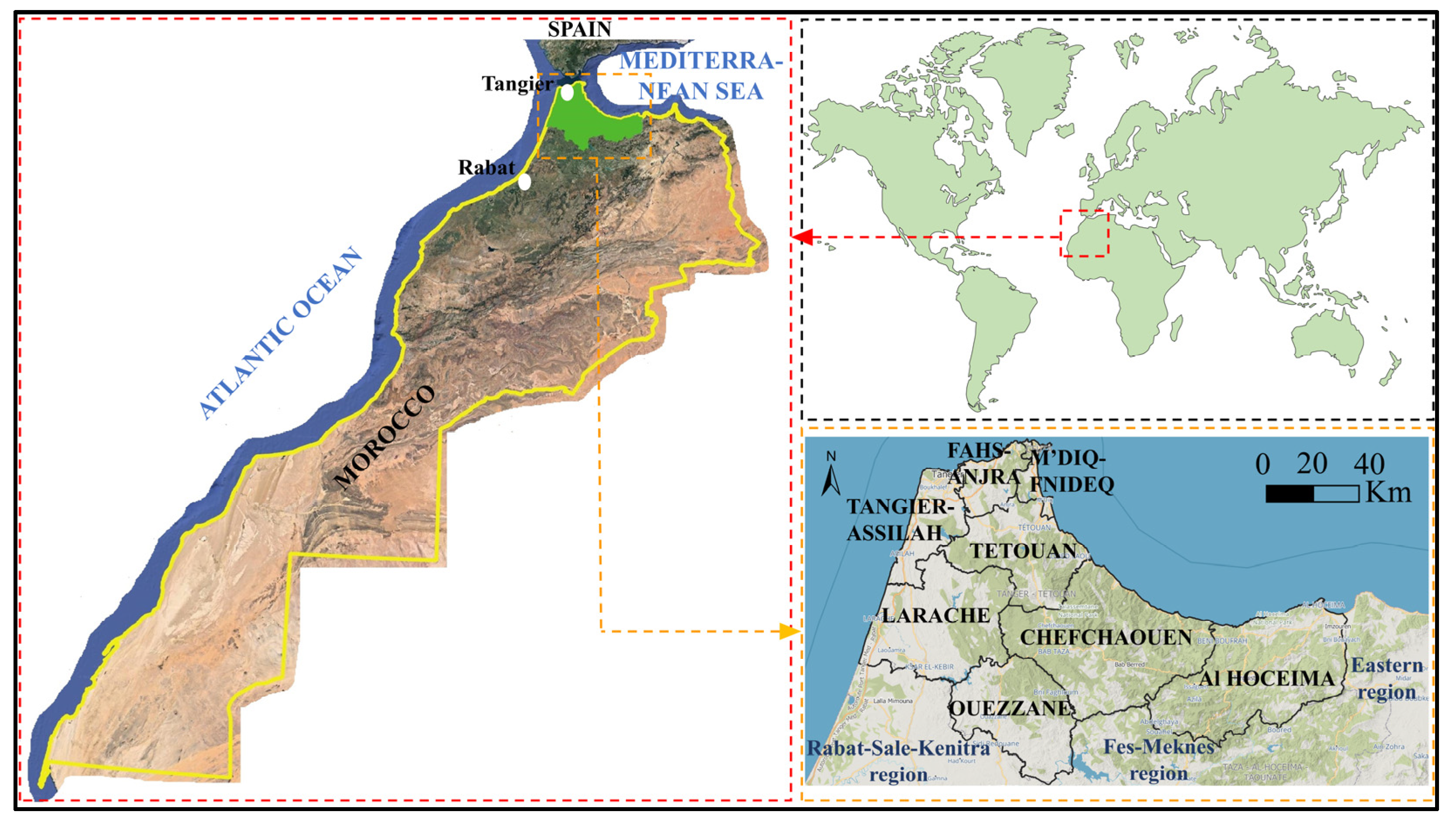
Figure 1. Geographic location of the study area.
Fire 06 00314 g001
Figure 2. Steps of land use mapping and calculation of the forest connectivity index in the TTA region: (a) GEE environment and code developed to extract DW data; (b) DW land cover classes in the TTA region; (c) generation of a binary map of forest and non-forest pixels; (d) downloading road network data from (OSM) and firebreaks digitization from Google Earth software; (e) extraction of the road network and firebreak layers from the binary map by applying buffer widths; and (f) forest connectivity index calculation using SAGA Fragmentation (Standard) module in QGIS.
Fire 06 00314 g002
Figure 3. Overall methodological approach of the study.
Fire 06 00314 g003
Figure 4. Spatiotemporal distribution of burned areas and active fires in the TTA region: (a) annually distribution of burned areas and active fires; (b) spatial distribution of burned areas from 2002 to 2020; (c) spatial distribution of active fires from 2001 to 2022.
Fire 06 00314 g004
Figure 5. Forest fire statistics by formation type: (a) total burned areas and active fire counts, the size of the bubbles reflects the total area of each formation; (b) percentages of burned areas by type of formation; (c) percentages of active fires counts by type of formation.
Fire 06 00314 g005
Figure 6. Spatial autocorrelation results for the two variables studied: (A) burned area, (B) active fire count. (1,2) are results for global and local autocorrelations, respectively. (a,b) are spatial autocorrelation reports and Moran scatter plots, respectively. (c,d) are clusters and statistical significance maps, respectively.
Fire 06 00314 g006
Figure 7. Hotspot mapping results for the two variables studied: (A) burned area, and (B) active fire count. (1,2) are results for OHA and EHA, respectively. (a,b) is spatial autocorrelation by distance graph and spatial distribution of HS/CS (at 3 significance levels) and insignificant cells, respectively.
Fire 06 00314 g007
Figure 8. Wildfire strategic response zones in the TTA region: (a) map of wildfire homogeneous zones; (b) description and characteristics of the zones, including (1) global statistics (area in km2 and %, annual wildfire rates), (2) land cover using DW data, and (3) EHA categories.
Fire 06 00314 g008
Figure 9. (a) Map of average forest connectivity index per km2. (b) Map of the spatial distribution of the three wildfire strategic response categories in order of priority.
Fire 06 00314 g009
Figure 10. (a) Projection of wildfires occurring between 2021 and 2023 in strategic response zones; (b) percentages of wildfires occurring between 2021 and 2023 by strategic response zones; (c) global scheme for evaluating the effectiveness of wildfire measures.
Fire 06 00314 g010
Table 1. Categories of the eight models of HS/CS identified by the EHA in the TTA region and their definitions [26].
ClasseModel NameDefinition
Hotspot (HS)/Coldspot (CS)New hotspot (NHS)/
New coldspot (NCS)
Location representing a statistically significant HS/CS for the final time interval that has never been a statistically significant HS/CS before.
Consecutive hotspot (CHS)/
Consecutive coldspot (CCS)
Location representing a single uninterrupted series of at least two statistically significant HS/CS in the final time intervals. The location was never a statistically significant HS/CS prior to the final series of HS/CS, and less than 90% of all bins represent statistically significant HS/CS.
Oscillating hotspot (OHS)/
Oscillating coldspot (OCS)
Statistically significant HS/CS for the final time interval that was also a statistically significant CS/HS during a previous time interval. Less than 90 percent of the time intervals were statistically significant HS/CS.
Sporadic hotspot (SHS)/
Sporadic coldspot (SCS)
Statistically significant HS/CS for the final time interval with a reactivated, then deactivated HS/CS history. Less than 90% of the time intervals were statistically significant HS/CS, and none of the time intervals were statistically significant CS/HS.
Table 2. Components of the Moroccan fire management strategy and details of actions [35].
ComponentActions
PreventionSensitization of the public to the dangers of fires and preventive measures: dissemination of awareness spots on television channels and announcements on the radio, popularization conferences at the level of douars, souks, etc.
Prohibition of forestry activities that use fire in forests (in the summer season).
Maintenance and clearing of the shoulders of roads, railways, and the rights of way of high voltage lines crossing the forests.
Launch of silvicultural and plantation maintenance operations.
Reinforcement of infrastructure and equipment in the forest environment, such as access roads, water points, forest tracks, and firebreak trenches.
Risk analysisDevelopment of prediction tools to assess the danger and anticipate the risks through static and dynamic maps of forest fires.
Providing managers with a cartographic decision support tool to define priorities related to surveillance systems and firefighting infrastructure and equipment enhancements.
PreparationInternally: Elaboration of programs, verification of equipment (rolling stock, small fighting equipment, clothing for firefighting personnel, means of communication and positioning, camping equipment, retardant products), and forest-defense-against-fires infrastructure.
With partners: communication and awareness, clearing and cleaning (security strips of public and private infrastructure located near or in forests), coordination at the level of wilayas and provinces, finalization and implementation of the prevention and control system with partners.
InterventionThe intervention strategy is based on a graduated system with four levels of intervention:
The first level is based on rapid management and support for the outbreak of fires by the services of the Water and Forests Department, thanks to first intervention vehicles and elements of Civil Protection with water tankers;
The second level is reinforced, if necessary, by the use of bomber planes (Canadair) of the Royal Air Force and, at the ground level, by the Auxiliary Forces to protect populations, properties, and sensitive equipment;
If the fire is not under control and continues to progress, the Royal Armed Forces, supported by the aircraft of the Royal Gendarmerie (Turbo Thrush) intervene at the third level.
When the extent of the fire becomes difficult to control by national means, recourse to international assistance to reinforce the national fleet involved in the aerial fight against forest fires is requested.
RehabilitationImplementation of actions to protect the soil from erosion and the protection of the burned area.
Reconstitution of the forest stand by natural or artificial regeneration actions.
Table 3. Descriptive statistics of burned areas and active fires by provinces/prefectures of the TTA region.
VariablesTime PeriodStatistical
Parameters
Al HoceimaChefchaouenFahs-AnjraLaracheMdiq-FnideqOuezzaneTangier-AssilahTetouanTotal TTA
Region
Burned
areas (km2)
2002–2020Number of observations19
Mean2.4214.840.9310.411.653.122.803.6139.78
Standard deviation4.7221.721.2012.203.539.064.526.5941.24
Minimum0.000.000.000.000.000.000.000.000.00
Maximum15.4284.723.6933.8214.5138.4214.3023.91136.82
Sum45.92281.8817.74197.8731.3359.1953.2268.59755.74
Active fires
counts
2001–2022Number of observations22
Mean9.1438.829.5548.503.868.829.8620.68149.23
Standard deviation9.7833.076.9967.697.4313.418.0820.34113.00
Minimum0315001330
Maximum381262532335533277516
Sum2018542101067851942174553283
Table 4. Burned area OHA and EHA statistics (area in km2 and %) in the provinces/prefectures of the TTA region.
OHAEHA
Province/PrefectureNSHSTotalOCSNHSOHSSHSTotal
Al Hoceima3400.71126.703527.4100000
Chefchaouen3166.71733.283899.99109914342303
Fahs-Anjra639.8422.96662.8001701229
Larache2145.19587.972733.161760522231
Mdiq-Fnideq137.79106.11243.9001619035
Ouezzane1956.73181.342138.065700057
Tangier-Assilah911.45118.391029.830003939
Tetouan1717.18204.301921.492907845
Total TTA
region
Area (km2)14,075.592081.0516,156.6437143222104740
%87.1212.8810050.235.8029.9614.01100
Table 5. Active fire OHA and EHA statistics (area in km2 and %) in the provinces/prefectures of the TTA region.
OHAEHA
Province/
Prefecture
CSNSHSTotalNCSCCSOCSSCSNHSCHSOHSTotal
Al Hoceima2891.14509.97126.303527.4100230180041
Chefchaouen1637.601264.63997.763899.9993304330183261
Fahs-Anjra30.88258.15373.77662.80000063514
Larache479.88923.331329.962733.1600001150260376
Mdiq-Fnideq0.00103.74140.16243.900000001818
Ouezzane1547.72368.62221.732138.060048060357
Tangier-Assilah258.94513.53257.361029.83000014201448
Tetouan399.901065.07456.521921.490029239045115
Total TTA
region
Area (km2)7246.065007.033903.5516,156.6493130623222529931
%44.8530.9924.161000.920.3113.930.6524.922.4056.87100
Table 6. Statistics of the three wildfire response strategies (area in km2 and %) in order of priority by province/prefecture.
StrategyMaintainMonitor and Raise AwarenessReinforce
PriorityVery
High
HighMediumLowTotalVery HighHighMediumLowTotalVery HighHighMediumLowTotal
Province/
Prefecture
Tetouan137.0227.3298.5741.61404.468.163.474107.3312.835.635.252.780.8204.3
Al Hoceima67.7132.2412.22695.13307.311.922.634.124.993.45.113.533.374.8126.7
Ouezzane112.1194.4343.31218.71868.47.515.44025.388.380.839.226.534.8181.3
Chefchaouen161.9255.4489.817582665.1114.8101.4111.3174.2501.7127.5171.8172.2261.7733.3
Larache7875.692.61123.71369.9145.7132.2109.7387.6775.2140.2137.890.3219.7588
Tanger–Assilah5.923.849.1671.9750.74.813.522.2120.4160.815.435.622.245.1118.4
Fahs-Anjra23.828.546.7189.7288.629.365.3103.7152.8351.21.23.65.512.723
Mdiq–Fnideq9.19.58.752.379.64.417.811.524.558.210.31933.343.6106.1
Total
region
Area (km2)595.5946.71740.98450.911,734386.4431.6506.41017.22341.6416.1455.7435.9773.32081
Priority %5.18.114.87210016.518.421.643.51002021.920.937.2100
Strategy %72.614.512.9
Disclaimer/Publisher’s Note: The statements, opinions and data contained in all publications are solely those of the individual author(s) and contributor(s) and not of MDPI and/or the editor(s). MDPI and/or the editor(s) disclaim responsibility for any injury to people or property resulting from any ideas, methods, instructions or products referred to in the content.