Perspective

Detecting, Monitoring and Foreseeing Wildland Fire Requires Similar Multiscale Viewpoints as Meteorology and Climatology
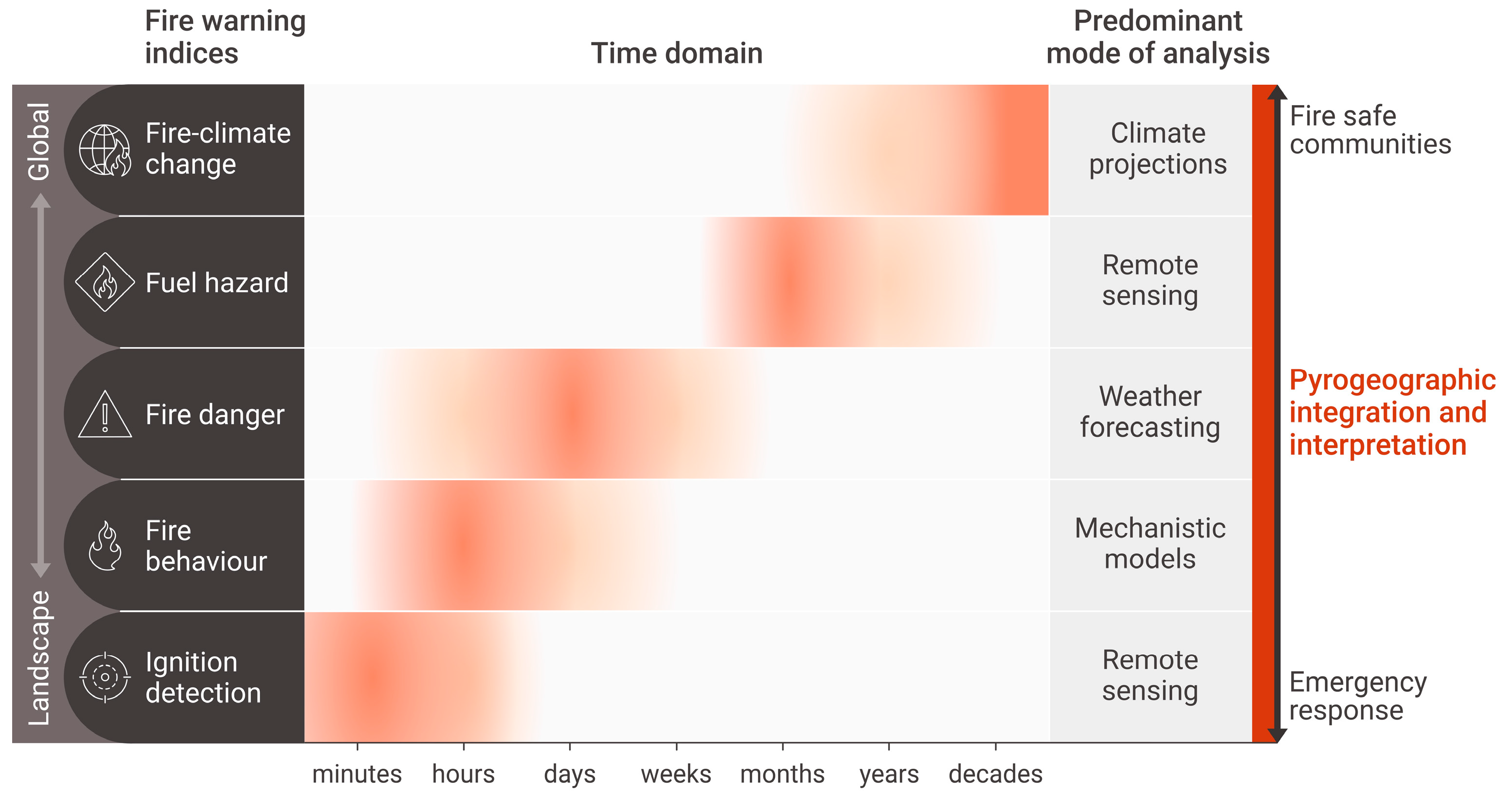
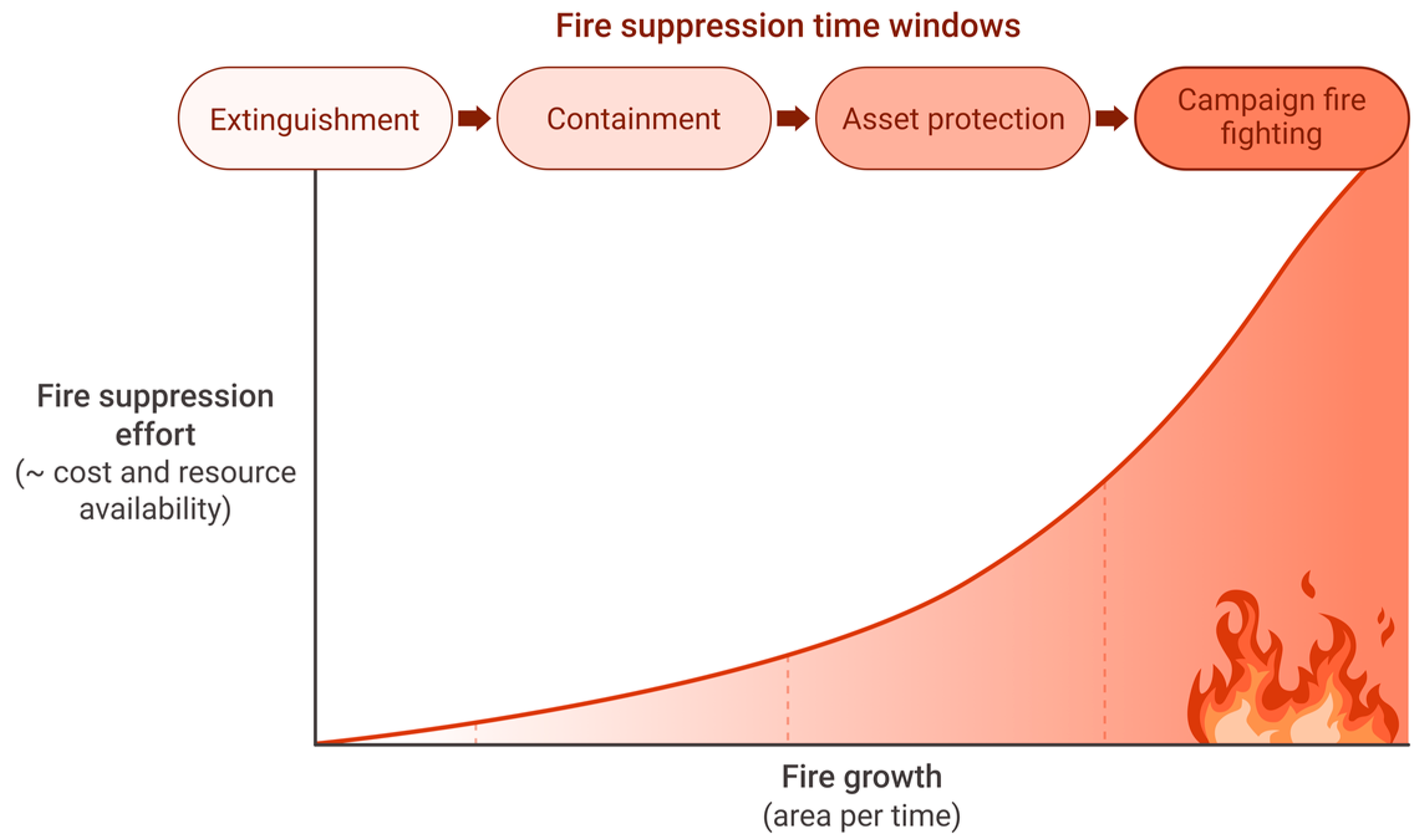
by
David M. J. S. Bowman
Fire Centre, School of Natural Sciences, University of Tasmania, Sandy Bay, Hobart, TAS 7001, Australia
Fire 2023, 6(4), 160; https://doi.org/10.3390/fire6040160
Submission received: 8 March 2023 / Revised: 22 March 2023 / Accepted: 8 April 2023 / Published: 17 April 2023

Abstract

:
Achieving sustainable coexistence with wildfires in the Anthropocene requires skilful integrated fire observations, fire behaviour predictions, forecasts of fire risk, and projections of change to fire climates. The diverse and multiscale approaches used by the atmospheric sciences, to understand geographic patterns, temporal trends and likely trajectories of weather and climate, provide a role model for how multiscale assessments of fire danger can be formulated and delivered to fire managers, emergency responders and at-risk communities. Adaptation to escalating risk of fire disasters requires specialised national agencies, like weather services, that provide to provide a diverse range of products to enable detection and near and longer-range prediction of landscape fire activity.

Wildland fires share many characteristics with atmospheric phenomena because both involve atomic through to global scale processes constrained by the laws of physics. Over the last several centuries, atmospheric scientists have carved out clear spatial and temporal domains for the study of diverse meteorological and climate phenomena, such as atmospheric chemistry, microclimatology, meteorology and weather forecasting, and global climate change projections [1]. Because of the scale and complexity of the processes involved, meteorology and climatology necessarily involve simplification, generalisation and probabilistic analysis [2]. There are striking parallels between the atmospheric sciences with the much younger and smaller discipline of wildfire science; however, the latter is less specialised and lacks a clear demarcation of subdisciplines and their associated spatiotemporal domains, methodologies and mode of analysis.
Broadly, there is a continuum from very detailed fire observations and predictions (e.g., wildfire fire detection and monitoring, fire behaviour modelling, fire weather forecasting) to a more general assessment of likely fire activity at regional and global scales [3]. Local near-term assessments of fire danger are essential for emergency responses, while regional and longer-term assessments provide a lead time for communities to adapt to changing fire risks (Figure 1).
The detection of fire has been a foundational objective of fire management, driving the creation of networks of staffed fire towers at the beginning of the 20th century and the development of aerial reconnaissance in the middle of the 20th century [4]. Since the beginning of the 21st century, these human-based remote sensing systems have been increasingly supplemented with more sophisticated and accurate technologies, such as ground-based, unoccupied aerial vehicles (UAV) and space-borne multispectral remote sensing systems [5]. Additionally, machine learning and artificial intelligence are being incorporated into the detection networks to automate the identification of fires beginning rapidly and at high spatial resolution [5]. To some degree, these rapidly advancing technologies have delivered ‘the dreams of fire control officers’ that inspired the developed human-based fire detection systems [4]. A key caveat is that near-perfect detection systems do not equate with equally near-perfect fire suppression.
It is well understood that wildfire suppression efforts track fire growth rates and fire sizes [6] (Figure 2). Once a fire reaches a critical size threshold, it is no longer possible to extinguish the fire [7], and as the fire grows, the objective of firefighting changes from containment and asset protection to mounting protracted firefighting campaigns to control the spread of the wildfire across landscapes. The reality of the inability to quickly extinguish all fire in landscapes and thus avoid large and often destructive wildfires raises profound unresolved questions about effective fuel management and appropriate firefighting strategies [8].
The data and approaches required to prepare for fire management and firefighting missions beyond fire detection and the initial attack mission are shaped by different spatiotemporal domains (Figure 2). Fire behaviour models that combine meteorological conditions, vegetation, fuel loads and terrain are able to predict the likely intensity, rate of spread and geographic patterns of individual wildfires in the near term, thereby assisting firefighters in warning communities, devising suppression plans and allocating resources [9]. Weather forecasts, based upon predictive models of ground-based and remote sensing meteorological observations, are pivotal in flagging upcoming fire weather. Such weather forecasts are essential for assessing fire danger, thereby assisting strategic decision-making, including restricting setting fires outdoors [10]. Measurements of fuel biomass and moisture are critical for assessing fire-season landscape fire hazards, and increasingly, this measure can be derived from satellite data [11,12]. Anticipating likely fire activity in response to climate change relies upon the Earth System models framed around various likely climate and human development scenarios [13]. While artificial intelligence systems have a role in integrating empirical observations from monitoring networks and the associated outputs from computer models, any such AI outputs must receive careful oversight and interpretation by experts [14] (Figure 1).
At the beginning of this Perspective, I drew attention to the parallels of landscape fire to the atmospheric sciences. Meteorologists and climatologists have long realised the need for multiscale observations and analyses to underpin weather monitoring, forecasting and climate change modelling and the effective integration of these different perspectives—tasks that have become more important because of the escalating climate crisis [15]. Undertaking systematic and continuous meteorology and climatology observations and modelling, and disseminating and communicating these findings to the public, led to the creation of weather service organisations. Consequently, modern weather services routinely provide real-time observation, such as rain radars, formulate local weather forecasts, track major storms, and alert the public to the development of dangerous weather events using a variety of media.
Likewise, in order to effectively control wildland fires and adapt to their escalating risk, a careful integration of multiscale observations and analyses is demanded [3]. I suggest that, like government weather services, there is a need for a government agency, which could be called the ‘Bureau of Pyrogeography’, to provide the public with a diverse range of products to detect and predict landscape fires. For example, such an organisation could provide communities and managers with an enhanced situational awareness of wildfires by using web-based tools to deliver real-time lightning data, fire-start detections and forecasts of dangerous fire weather. To help communities prepare and adapt to the threat of wildland fire disasters, such an organisation could provide seasonal outlooks of fuel hazards and longer-term trends in fire danger driven by climate change. It is true that many of these analyses and outputs already exist in various forms, but they are neither systematically related nor based on consistent and repeatable methods.
In Australia, for example, the states and territories have their own methods of monitoring and predicting landscape fires and are not easily integrated on a national scale, creating data harmonisation issues on state boundaries [16]. The need for national standardisation is increasingly recognised amongst Australian fire managers, leading to the development of a national fire danger rating system [17]. Although fire spread predictions are not routinely shared publicly in Australia, research has shown that the public can use fire prediction maps to make informed decisions during wildfire emergencies [18]. The Australian Bureau of Meteorology (BoM) forecasts are used by state and territory fire agencies to regulate the setting of landscape fires [19], and the Australian and New Zealand National Council for Fire and Emergency Services (AFAC) provides seasonal bushfire outlooks based on the expert opinions of state and territory fire agencies and the BoM [20].
In order to maximise the impact of the increasing quantity and quality of fire observations from ground, aerial and space-borne monitoring requires centralised analysis and dissemination to achieve economies of scale, seamless public delivery and consistency of methodological approaches [3,16]. Investment in nationally coordinated fire observations, fire behaviour prediction, forecasts of fire risk, and projections of change to fire climates is essential in achieving sustainable coexistence with Anthropocene wildfires [3,16,21].

Funding

This research was funded by the Australian Research Council Laureate Fellowship, grant number FL220100099.

Institutional Review Board Statement

Not applicable.

Informed Consent Statement

Not applicable.

Data Availability Statement

Not applicable.

Acknowledgments

This Perspective was stimulated by participation in the ‘Temperate and Mountainous Forests’ meeting of the ‘Early Detection of Wildfires’ series hosted by the USA National Academies of Sciences, Engineering and Medicine and sponsored by the Environmental Defense Fund and the Minderoo Foundation. I thank Stacey McCormack at Visual Knowledge for preparing the graphics and for the discussion with Grant Williamson as I formulated this Perspective.

Conflicts of Interest

The author declares no conflict of interest.

References

  1. Crutzen, P.J.; Ramanathan, V. The ascent of atmospheric sciences. Science 2000, 290, 299–304. [Google Scholar] [CrossRef] [PubMed]
  2. Petersen, A.C. Philosophy of climate science. Bull. Am. Meteorol. Soc. 2000, 81, 265–272. [Google Scholar] [CrossRef]
  3. Crowley, M.A.; Stockdale, C.A.; Johnston, J.M.; Wulder, M.A.; Liu, T.; McCarty, J.L.; Rieb, J.T.; Cardille, J.A.; White, J.C. Towards a whole-system framework for wildfire monitoring using Earth observations. Glob. Chang. Biol. 2023, 29, 1423–1436. [Google Scholar] [CrossRef] [PubMed]
  4. Zimmerman, E.W. Forest Fire Detection; US Department of Agriculture: Washington, DC, USA, 1969; Volume 38.
  5. Barmpoutis, P.; Papaioannou, P.; Dimitropoulos, K.; Grammalidis, N. A review on early forest fire detection systems using optical remote sensing. Sensors 2020, 20, 6442. [Google Scholar] [CrossRef] [PubMed]
  6. Simpson, H.; Bradstock, R.; Price, O. A temporal framework of large wildfire suppression in practice, a qualitative descriptive study. Forests 2019, 10, 884. [Google Scholar] [CrossRef]
  7. Hirsch, K.G.; Martell, D.L. A review of initial attack fire crew productivity and effectiveness. Int. J. Wildl. Fire 1996, 6, 199–215. [Google Scholar] [CrossRef]
  8. Riley, K.L.; Thompson, M.P.; Scott, J.H.; Gilbertson-Day, J.W. A model-based framework to evaluate alternative wildfire suppression strategies. Resources 2018, 7, 4. [Google Scholar] [CrossRef]
  9. Alexander, M.E.; Cruz, M.G. Limitations on the accuracy of model predictions of wildland fire behaviour: A state-of-the-knowledge overview. For. Chron. 2013, 89, 372–383. [Google Scholar] [CrossRef]
  10. Plucinski, M. The timing of vegetation fire occurrence in a human landscape. Fire Saf. J. 2014, 67, 42–52. [Google Scholar] [CrossRef]
  11. Szpakowski, D.M.; Jensen, J.L. A review of the applications of remote sensing in fire ecology. Remote Sens. 2019, 11, 2638. [Google Scholar] [CrossRef]
  12. Yebra, M.; Dennison, P.E.; Chuvieco, E.; Riaño, D.; Zylstra, P.; Hunt Jr, E.R.; Danson, F.M.; Qi, Y.; Jurdao, S. A global review of remote sensing of live fuel moisture content for fire danger assessment: Moving towards operational products. Remote Sens. Environ. 2013, 136, 455–468. [Google Scholar] [CrossRef]
  13. Bowman, D.M.; Kolden, C.A.; Abatzoglou, J.T.; Johnston, F.H.; van der Werf, G.R.; Flannigan, M. Vegetation fires in the Anthropocene. Nat. Rev. Earth Environ. 2020, 1, 500–515. [Google Scholar] [CrossRef]
  14. Jain, P.; Coogan, S.C.; Subramanian, S.G.; Crowley, M.; Taylor, S.; Flannigan, M.D. A review of machine learning applications in wildfire science and management. Environ. Rev. 2020, 28, 478–505. [Google Scholar] [CrossRef]
  15. Uccellini, L.W.; Ten Hoeve, J.E. Evolving the National Weather Service to build a weather-ready nation: Connecting observations, forecasts, and warnings to decision-makers through impact-based decision support services. Bull. Am. Meteorol. Soc. 2019, 100, 1923–1942. [Google Scholar] [CrossRef]
  16. Bowman, D.; Williamson, G.; Yebra, M.; Lizundia-Loiola, J.; Pettinari, M.L.; Shah, S.; Bradstock, R.; Chuvieco, E. Wildfires: Australia needs national monitoring agency. Nature 2020, 584, 188–191. [Google Scholar] [CrossRef] [PubMed]
  17. AFAC. Australian Fire Danger Rating System (AFDRS). Available online: https://www.afac.com.au/initiative/afdrs/afdrs-overview (accessed on 21 March 2023).
  18. Whittaker, J.; Haynes, K.; Wilkinson, C.; Tofa, M.; Dilworth, T.; Collins, J.; Tait, L.; Samson, S. Black Summer: How the NSW Community responded To the 2019–20 Bushfire Season; Bushfire and Natural Hazards CRC: East Melbourne, VIC, Australia, 2021. [Google Scholar]
  19. Bureau of Meteorology. Fire Weather Services. Available online: http://www.bom.gov.au/weather-services/fire-weather-centre/fire-weather-services/ (accessed on 21 March 2023).
  20. AFAC. Seasonal Bushfire Outlook. Available online: https://www.afac.com.au/docs/default-source/bushfire-seasonal-outlook/seasonaloutlook_summer_2022_v1-0.pdf (accessed on 21 March 2023).
  21. Bowman, D. Wildfire science is at a loss for comprehensive data. Nature 2018, 560, 7–8. [Google Scholar] [CrossRef] [PubMed]
Figure 1. Conceptual model of the spaciotemporal domains of detecting, monitoring and foreseeing wildland fire. There is a spectrum from place-based detection, monitoring and prediction of wildland fires, which is essential for firefighting, to a more geographically broad-scale assessment of likely future fuel hazards and fire-climate change that assists community and national planning and adaptation to landscape fires. Expert integration, interpretation and public communication of these different streams are essential for effective emergency responses and fire management.
Fire 06 00160 g001
Figure 2. Conceptual relationship with cumulative fire suppression effort/cost with fire growth. Once a fire achieves a critical size, firefighting objectives shift from extinguishment to containment and asset protection and can develop into extremely expensive and long-running firefighting campaigns.
Fire 06 00160 g002
Disclaimer/Publisher’s Note: The statements, opinions and data contained in all publications are solely those of the individual author(s) and contributor(s) and not of MDPI and/or the editor(s). MDPI and/or the editor(s) disclaim responsibility for any injury to people or property resulting from any ideas, methods, instructions or products referred to in the content.

