Article

Canadian Fire Management Agency Readiness for WildFireSat: Assessment and Strategies for Enhanced Preparedness

1
Natural Resources Canada, Canadian Forest Service, Great Lakes Forestry Centre, Sault Ste. Marie, ON P6A 2E5, Canada
2
Ontario Ministry of Natural Resources and Forestry, Aviation Forest Fire and Emergency Services, Sault Ste. Marie, ON P6A 6V5, Canada
3
British Columbia Ministry of Forests, Wildfire Service, Victoria, BC V8W 9C1, Canada
4
Forest Management Division, Department of Environment and Natural Resources, Government of the Northwest Territories, Fort Smith, NT X0E 0P0, Canada
*
Author to whom correspondence should be addressed.
Submission received: 26 January 2023 / Revised: 11 February 2023 / Accepted: 14 February 2023 / Published: 16 February 2023

Abstract

:
Wildfires are worsening in Canada and globally, partly due to climate change. The government of Canada is designing and building WildFireSat, the world’s first purpose-built operational satellite system for wildfire monitoring. It will provide new fire intelligence to support decision-making. It takes time for fire management agencies to use new information: to understand it and its implications, change processes, develop training, and modify computer systems. Preparing for the system’s prelaunch will allow agencies to benefit more rapidly from the new information. We present (1) an assessment of the readiness of 12 Canadian fire management agencies to integrate WildFireSat information and (2) guidance for reducing readiness gaps. We used survey and other data to score readiness indicators for three readiness components: understanding, organization, and information technology. We weighted the influence of each indicator score on each component. We modelled scoring and weighting uncertainties and used Monte Carlo simulation to generate distributions of aggregated agency readiness. The results indicated that most agencies have a moderate level of readiness while others have a higher level of readiness. Cluster analysis was used to group agencies by similarity in multiple dimensions. Strategies for increasing readiness are highlighted. This identifies opportunities for agencies and the WildFireSat team to collaborate on enhancing readiness for the forthcoming WildFireSat data products.

1. Introduction

In Canada and around the world, wildfires can be both beneficial as part of natural wildland functioning [1] and tragically catastrophic; for example: the 2016 Horse River fire in Alberta, Canada [2], and the Black Saturday Kilmore East fire in Victoria, Australia [3]. Expected future wildfire challenges in Canada and globally are well documented [4,5,6]. Under the effects of climate change, Canadian wildfires are expected to see increases in frequency [7,8], severity [9,10], and season length [11,12], leading to larger social, economic, and environmental impacts [13,14,15,16]. In addition, there are challenges that will be faced by those who manage wildfire risk; however, there are also a wide variety of options for mitigating and adapting to this risk [17,18]. Improving the information available for better decision making in fire management is one such strategy to help reduce risk [19]. Recent advancements in remote sensing technology have the potential to provide more of this critical information.

1.1. Fire Intelligence and Use

Decision-making in operational fire management can be challenging. Decisions must often be made with incomplete information and can have significant consequences with interacting and cascading impacts [18,20]. For interested readers, Martell [21] describes several fire management decisions and decision-support needs that are common in a Canadian context, and Zimmerman [19] does the same for the United States of America. In all cases, and especially in periods of escalated wildfire activity, reliable intelligence about wildfires is critical for shared situational awareness and informed decision-making [19,22,23]. For decision-makers, the fire management decision space is fraught with uncertainty [24]; one strategy to reduce uncertainty is to collect more information [25]. The post-fire review of the Horse River fire in Alberta, Canada (one of the costliest in Canadian history [26]) recommended improving information availability, specifically by enhancing access to remote sensing data and technology [2]. However, if information is incorrect, or the amount of it is overwhelming, this can have detrimental effects; a study on Incident Management teams found that information overload contributed to uncertainty [22]. Thus, it is important to deliver the right information to the right people, in the right way. Designing these systems to support decision-making requires a strong understanding of the decisions being made and how people are making them within their organization [27].

1.2. WildfFireSat

Canada’s Federal 2022 budget aimed to address some of the challenges faced by fire management in Canada by providing end-to-end funding for a new wildfire monitoring satellite system [28]. This new satellite system, WildFireSat, represents a joint project across four government organizations: the Canadian Space Agency, Environment and Climate Change Canada, Natural Resources Canada’s Canadian Forest Service (CFS), and the Canadian Centre for Mapping and Earth Observation. It will be the world’s first purpose-built operational satellite system for wildfire monitoring [23] and will prioritize fire management users with a multi-tiered product suite. WildFireSat is designed on the premise of forming a virtual constellation with VIIRS and will provide reliable Earth observation data and data products that will support tactical and strategic fire management decision-making. These products are conceptually organized under three tiers: (1) satellite-level fire products, (2) fire behaviour through data synthesis with other satellites, and (3) inputs to existing fire modelling and decision support tools [23]. WildFireSat has a planned operational mission of five years [29] and is targeted to be available for fire management around the 2029 Canadian fire season.

1.3. Readiness for WildfFireSat

Organic progression towards uptake is characteristic of research and development for new satellite data, which gradually spurs new science and new products. This has been successful and led to a highly mature science surrounding active fire earth observation. Wooster et al. [30] review this history and the applications of remote sensing for active fire.
For WildFireSat, however, allowing time for organic, post-launch, fire management agency adoption is an inefficient use of finite orbit time given the specificity of the mission objectives. Therefore, the rate and extent of WildFireSat data product integration into operational fire management is very important. The WildFireSat program aims to maximize the satellite’s utility for operational fire management from the onset through deliberate product design, testing, and proactive fire management community knowledge exchange (KE). This will ensure the maximum return on investment for the five-year design life of the mission, which could be much longer. For example, other satellites had lifespans that were decades longer than the planned mission parameters (e.g., Terra and Aqua were designed to last 6 years but are 20+ years active [31,32]).
Prelaunch preparedness was identified as important and explored for other operational uses of satellite data [33,34]. Additionally, some factors could hinder the adoption of WildFireSat products by Canadian fire management agencies, such as lack of feelings of participation and ownership, and insufficient capacity [35]. The WildFireSat User and Science Team saw the need for active fire management community engagement and assessment of users’ readiness in their summary of WildFireSat user requirements:
“…the key to operational success remains in the hands of the wildfire management community. In order to achieve meaningful impact in wildfire management operations, the end-user engagement described in this study must continue for the duration of the mission to ensure that wildfire management needs continue to be heard and that wildfire managers develop a sense of ownership in the mission.”
Johnston et al. [23].
There is already good evidence of high-level readiness for organizational change [36] within fire management agencies, especially for innovations such as WildFireSat. The collaboratively authored Canadian fire management reports that call for and support change and innovation are excellent examples of readiness for change and future-oriented perspectives within Canadian fire management [37,38,39]. Change-ready organizations often have a strong future focus when making strategic decisions [40]; however, we can benefit by more specifically evaluating end-user readiness as the first step in supporting WildFireSat integration.
Generally thought of as a precursor to actual change [41], readiness in a technology transfer context is defined as “...an organization’s assessment of its state of being prepared for effective production or adoption, assimilation and exploitation of digital technologies for innovation” [42]. The concept of readiness has been explored across a variety of fields such as adaptation [43], change [36], and knowledge exchange [44].
Evaluating an organization’s state of readiness is complex and requires the consideration of the organization’s and their individuals’ attributes [36,41,45,46]. McFayden et al. [44] draw attention to readiness for innovation as a potential barrier—or facilitator—to success within a KE framework for wildfire management. Early and iterative engagement has been shown to be essential in fire management [35]. There is a high risk to the success of WildFireSat in leaving adoption to passive efforts. To that end, it is important to assess end-user readiness as a baseline, as it can be used to identify which users are likely to require support from further KE efforts [47].
Several strategies can be used to actively facilitate readiness. For example, Rapp et al. [27] explore the use of wildland fire decision support tools in the US and provide recommendations including opportunities for training and social connections. Goodman et al. [48] discuss initiatives to increase user readiness for geostationary environmental satellites that included feedback for training needs and potential uses. Similarly, a report on engaging the user community for advancing societal applications of the Surface Water Ocean Topography mission identified the need to engage the user community early for education on data products and uncertainty, and to ensure access for varied levels of expertise and formats [49]. For the Canadian Ice Service’s use of RADARSAT, Arkett et al. [34] suggest the need for data assimilation and automation to support preparedness.

1.4. Objectives

The aims of this study are to determine the current level of readiness of fire management agencies in Canada to fully implement WildFireSat, explore the similarities and differences between agencies, and inform the strategic development of pre-launch WildFireSat readiness activities. This work is intended to ensure that Canadian fire management agencies are aware, equipped, and ready to fully benefit from WildFireSat once available.

2. Methods

There are several approaches to assessing readiness. Ford and King [43] detail the manner in which data can be systematically collected with indicators derived from binary variables, ordinal ranking, or continuous measures. In situations where there are complex system interactions, it is difficult to account for these interactions via any single mode of analysis, although expert assessments have been used as an approach to collect perspectives [50]. This kind of engagement with subject matter experts is common within fire management research [23,37,51,52,53,54,55,56]. Characterizing the elements of Canadian fire management agencies and their needs through survey data and direct engagement with fire management agencies is also common [37,57,58,59,60]. Our methodology necessarily relies heavily on expert elicitation, a relatively rapid and inexpensive means of evaluating the state of knowledge in a field [61]. We followed a similar elicitation approach to that outlined by Knol et al. [61], and assess wildfire management agency organizational readiness for WildFireSat products via six key steps: (1) determine our construct for readiness; (2) determine the scope; (3) design and complete the agency survey; (4) score indicators of agency readiness; (5) assign weights to the contribution of indicator scores to readiness; (6) characterize uncertainty and calibrate with fire management subject matter experts. In addition to the steps outlined by Knol et al. [61], we take an additional 7th step to explore agency similarities and extract several strategies from the survey responses that could be used to increase fire management agency readiness.

2.1. Determine our Construct for Readiness

The language we use to define complex concepts is important, especially when it comes to fire management [18,54,62], to avoid miscommunication and contributing to uncertainty [24]. Therefore, we define the terms relevant to this study as follows. We consider Readiness to be the willingness and capacity of fire management agencies to adopt, assimilate, exploit, and integrate WildFireSat fire intelligence into operational policies, procedures, and practices of wildfire management (adapted from Cambridge University Press [63]). We define Implementation (used synonymously with the terms integration and adoption) as the process of putting WildFireSat products into action via policies, procedures, and practices in support of fire management. For discussions about other terms used, see McFayden et al. [44] for knowledge exchange, Johnston et al. [18] for risk, and [64] for other Canadian fire management terms.
Our conceptual and quantitative formal models [65] rely on a construct of readiness structured as a two-level hierarchy. At the upper level, we postulated that readiness depends on three primary components. Drawing from the perspectives of Gopalakrishnan and Santoro [45], Ford and King [43], Yusif et al. [46], and McFayden et al. [35], we focus on the following three readiness components for this given case:
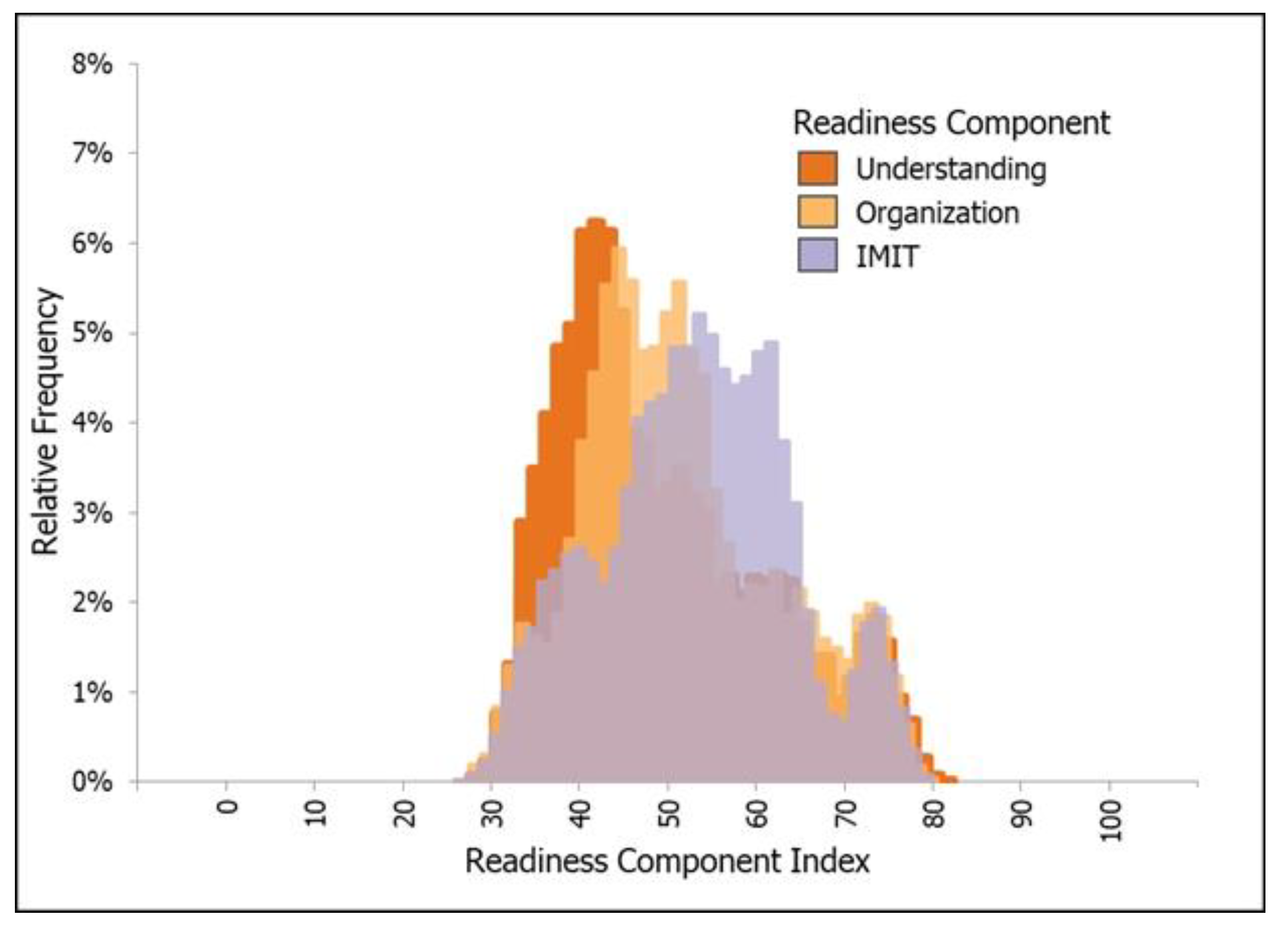
  • Understanding: This factor considers the degree and scope of knowledge about remote sensing, associated products, and uses within an agency (e.g., planning, interpretation, and decision-making using spatial and modelling products). A high level of understanding of remote sensing and associated modelling suggests that agencies are better positioned to envision where and how WildFireSat products can integrate into current operations. This can include inference on the degree of change necessary in policies, procedures, and practices, as well as the willingness to make the appropriate changes.
  • Organization: This factor considers the capacity of the people, culture, processes, and agency structure to incorporate WildFireSat data products into policies, procedures, and practices. A high level of organization capacity signifies that there are elements (such as administrational supports and flexible processes) in place to develop the necessary implementation plans (e.g., training, procedures, communications). This can also mean that the agency has a culture of innovation, support from champions and upper management, and openness to use remote sensing and associated products.
  • Information management and information technology (IMIT): This factor considers the agility, familiarity, and processes required to implement WildFireSat data products and is specific to the hardware, software, storage, organization, and retrieval of information and data within an agency. Although this indicator is one element of overall organizational readiness, it is important to assess this separately given the specific support required from IMIT due to the nature of the products expected with WildFireSat and how they must be integrated by agencies in their IMIT systems.
We believe that all three of these distinct organizational characteristics are needed in good measure for high overall readiness. If any one or two of these characteristics is lacking, then overall readiness is constrained accordingly.
At the lower level of the readiness hierarchy, we postulated that the three main components can be determined by characteristics of the fire management agencies. These characteristics, which can be elicited from survey and other data, are used as indicators to infer the level of readiness. These indicators are interdependent and interact to influence eventual readiness components through weights of relevance or importance [43]. Figure 1 illustrates our general approach and the relationship between the data collected and our readiness components.

2.2. Determine the Scope

Regarding the scope of the survey, the Canadian Interagency Forest Fire Centre (CIFFC) Directory of Fire Management Personnel [66] lists 13 Forest Fire Management Agencies that, together, employ many hundreds of people across diverse organizational units. Generally, operational wildland fire management in Canada is done by Provinces and Territories, which are important expected users of WildFireSat. We did not seek to assess the readiness of individual people within fire management agencies (nor capture individual opinions) but, rather, to broadly assess each individual agency. This approach reduced the chance of introducing bias with different sampling techniques [67] and ensured that the appropriate subject-matter experts were engaged with the survey without over-representing sub-groups.
We approached the CIFFC Management Committee (composed of fire management agency Directors) and requested that each agency complete the survey (Prince Edward Island was not included in the survey. The Department of National Defence—Canadian Forces Fire Marshal did participate in the survey but was not included in this survey analysis due to the difference in organizational responsibilities and activities for fire management relative to the Provinces, Territories, and Parks Canada). The 12 agencies that participated in the survey included British Columbia (BC), Alberta (AB), Saskatchewan (SK), Manitoba (MB), Ontario (ON), Quebec (QC), Newfoundland and Labrador (NL), New Brunswick (NB), Nova Scotia (NS), Yukon Territory (YT), Northwest Territories (NT), and Parks Canada (PC). We also asked each agency to identify a point-of-contact knowledge broker to facilitate the distribution and completion of the survey.
Access to agency knowledge brokers as a part of an ongoing WildFireSat knowledge exchange team facilitates real, mutual engagement with the fire management agencies and moves beyond token outreach exercises [43]; as well, it allows for bi-directional flows of knowledge between the development team and the fire management practitioners [68].

2.3. Design and Complete the Agency Survey

For simplicity, we elected a survey that would capture an official agency response via a single written reply. Our aim was to collect responses based on the knowledge of authorized subject-matter experts within each agency. We provided instruction on selecting the necessary expertise to respond to the questions either independently or in a group; however, we left it to the agencies to determine the most appropriate experts and teams to respond to the questions.
As explained to the agencies, the purpose of the survey was to identify agency characteristics and structure, assess familiarity with remote sensing and adaptiveness to innovation, and qualify the technical requirements needed for implementation. From these questions, we could assess the overall current-state readiness of each agency. The agencies were additionally provided with details on data collection and use, an introduction to WildFireSat, and examples of potential operational products. We presented an overview of the knowledge exchange program and study objectives to each agency’s point-of-contact. Designed by the WildFireSat mission leadership team, the survey consisted of a mix of free text, ranking, and multiple-choice questions (see Supplementary Materials S1 for samples of the survey questions). All surveys were completed over an 8-month period, providing time for careful consideration.

2.4. Score Indicators of Agency Readiness

We drew inferences about agency readiness from two data sources: agency survey responses (as described above) and quantitative measures of agency workload and activities. These quantitative measures included data characterizing the environment, workload, and funding experienced by each agency.
Twenty-six numerical indicators were created from the survey responses. Each indicator was subjectively scored with a number based on the question type and the range of other responses. To illustrate, a question asking about the number of partners was simply the count provided, whereas a question asking for a description of the current use of remote sensing required interpretation of responses and was mapped onto a custom scale. An additional nine quantitative indicators were created from data detailing agency workload and activities.
All 35 indicators (Table 1 and Table 2) and scores are the outcome of an iterative review, adjustment, and refinement process. All indicator score scales were then transformed to a 0–10 scale for analysis. The few indicator score scales for which a lower score was proportional to more readiness were transformed such that all 35 scales have higher scores proportional to more readiness.
In addition to scoring the agency responses and data, we created a hypothetical agency that was assumed within the framework of the 35 indicators to be as ready as possible to use WildFireSat data products. Its purpose was to provide context for the interpretation of agency results. The hypothetically ready agency was assigned the maximum possible score for each indicator.

2.5. Assign Weights to the Contribution of Indicator Scores to Readiness

The weight or strength of the relationship between each indicator and agency readiness components (understanding, organization and information management, and information technology) were assigned through expert elicitation. In an iterative process, we assigned a contribution weight from 0–50 to each indicator. The first iteration was largely based on the authors’ collective experience and knowledge. Further iterations and updates to the weights were based on elicitation from agency experts after group presentations of the method with narratives and discussions. Some examples of the narratives used in the weighting are included in Supplementary Materials S2.
The indicator scores and contribution weights were used to determine various measures of readiness according to the following equations:
A g e n c y   R e a d i n e s s   C o m p o n e n t   I n d e x a , c =   i = 1 35 ( I n d i c a t o r   S c o r e a , i   ·   C o n t r i b u t i o n   W e i g h t i , c ) A g e n c y   R e a d i n e s s   C o m p o n e n t   I n d e x H , c   · 100 ,
where a is the index of the 12 agencies, i is the index of the 35 indicators, c is the index of the 3 readiness components, and H is the hypothetically-ready agency. The Agency Readiness Component Index for the hypothetically-ready agency is defined as:
A g e n c y   R e a d i n e s s   C o m p o n e n t   I n d e x H , c = i = 1 35 ( I n d i c a t o r   S c o r e H , i   ·   C o n t r i b u t i o n   W e i g h t i , c ) .
The measure of each agency’s overall readiness is given by the Agency Readiness Index:
A g e n c y   R e a d i n e s s   I n d e x a = min c ( A g e n c y   R e a d i n e s s   C o m p o n e n t   I n d e x a , c ) ,
which is the minimum of the three readiness component indices (understanding, organization, and IMIT), as illustrated in Figure 1. All three components of readiness support overall agency readiness, with the smallest component constraining the overall level of current readiness (analogous to having three pillars to make a raised platform; the shortest pillar determines the height).
The rationale for using the minimum is described in these scenarios. Consider some fictious agency whose decision-makers could fully understand WildFireSat information and whose organization could readily change its planning processes to use the information, but whose IMIT unit did not have the capacity to modify its computer systems to provide the information. As a result, the agency could not use the satellite-derived information. Consider another example agency with an IMIT unit that has the agility to implement new products and whose organization can develop and implement new processes, but whose decision-makers lack the requisite level of understanding to interpret and apply WildFireSat information to decision-making. The result would be the same. A similar scenario can be constructed for the third readiness component, with the same result. We recognize that these scenarios are caricatures and that using the minimum is an extreme condition that provides a lower bound on agency readiness. The lower bound is nonetheless useful for illustration and, as described below, the application of the results to assist agencies will be based on specific needs and interests.
While agency-level metrics are useful, based on agency preferences we have aggregated them to a national level for this study. We define the Collective Readiness Component Index as a histogram of the Agency Readiness Component Index from Equation (2). Similarly, we define the National Readiness Index as a histogram of the Agency Readiness Index from Equation (3).

2.6. Characterize Uncertainty and Calibrate with Fire Management Subject Matter Experts

The model described above is deterministic; however, there are two key areas of uncertainty:
  • The indicator scores may not accurately represent the agency’s state because:
  • The survey questions may have been misinterpreted, or
  • The survey responses may not represent the agency’s state, or
  • The survey responses may have been misinterpreted when scoring the indicators.
2.
The contribution weights may not accurately represent the strength of the relationship between each indicator and the agency readiness component.
Therefore, we constructed a stochastic version of the model that is analogous to the deterministic version except that selected variables have been changed to random variables. That is, the I n d i c a t o r   S c o r e a , i   and C o n t r i b u t i o n   W e i g h t i , c become random input variables, while the left-hand side variables are intermediate or output random variables. The distributions of the input random variables are determined as follows.
The first area of uncertainty was incorporated into the model using an adjective confidence rating assigned to the indicator score by the coding author. The confidence rating was in the set of: very likely, likely, 50-50, unlikely, and very unlikely. This was done depending on the author’s certainty regarding the agency’s ability to respond, and confidence in their own indicator scoring abilities. Originally, each adjective rating had a corresponding numerical likelihood between 93% and 5%; see Weber and Hilton [74] for justification. To implement the Monte Carlo model, we instead translated the confidence ratings into probability distributions of the indicator score random variables. The distributions are based on discussions with wildfire management agency subject-matter experts regarding the distribution shapes that are appropriate for representing varying levels of confidence (Figure 2a,b). Note that each distribution is a BetaSubjective distribution, a special form of the Pert distribution that is considered to be appropriate for capturing expert opinions and allows for intuitive parametrization [75].
The second area of uncertainty is associated with the contribution weight assigned to each indicator for each readiness component. The iterative process suggested the magnitude of the uncertainty. As such, we replaced every deterministic contribution weight with a random variable drawn from a Pert distribution which was parameterized based on previous model iterations. Specifically, we used the past record of assigned weights to set the distributions’ maximum and minimum parameters and present model weights to populate the most likely parameter.
We implemented the stochastic model using @Risk (Palisade Co., Ithaca, NY, USA, 2022), a Monte Carlo simulation extension that is appropriate for our spreadsheet-based model. This stochastic formulation of our model sampled the distributions assigned to the indicator scores and the contribution weights 1000 times. These distributions were used to re-calculate the Collective Readiness Component Index and the National Readiness Index histograms, which were also sampled 1000 times, producing distributions of index values.
For contextual purposes, the hypothetically-ready agency was also incorporated into the analysis at this stage. Conceptually, there would still be some variability within this hypothetically-ready agency, and we illustrate that by assigning a confidence rating of 93% to each indicator score to allow for some level of variation in readiness. Including this hypothetical agency illustrates the maximum index derived from the model; however, it does not suggest an optimal agency readiness level.

2.7. Explore Agency Similarities

We explored agency similarities across various themes visible within the indicators and subsets of indicators specific to those themes. The following themes are comprised of different indicators that correspond to the numbers in Table 2 and Table 3. Themes include: agency environment, workload, and funding (indicators 1–9); agency partnerships in delivery and development (indicators 10–13); organizational capacity for innovation and planning (indicators 14–17); familiarization with remote sensing (indicators 18–21); operational use of fire intelligence (indicators 22–25); policies and procedures for approving and implementing new intelligence (indicators 26–29); openness and engagement (indicators 30–31); information management and information technology (indicators 32–35). Using a standard Hierarchical Agglomerative Clustering (HAC) method, we repeatedly merged similar agencies until all agencies were merged [76]. This method is commonly known as UPGMA (Unweighted Pair Group Method with Arithmetic Mean) [77]; however, we extended this method slightly by adjusting the distance function by normalizing to compensate for blanks according to Dixon [78]. The resulting dendrograms are coloured by the rates of change in group similarity with respect to the index of the merging step. This is described in detail in Supplementary Materials S3.

3. Results

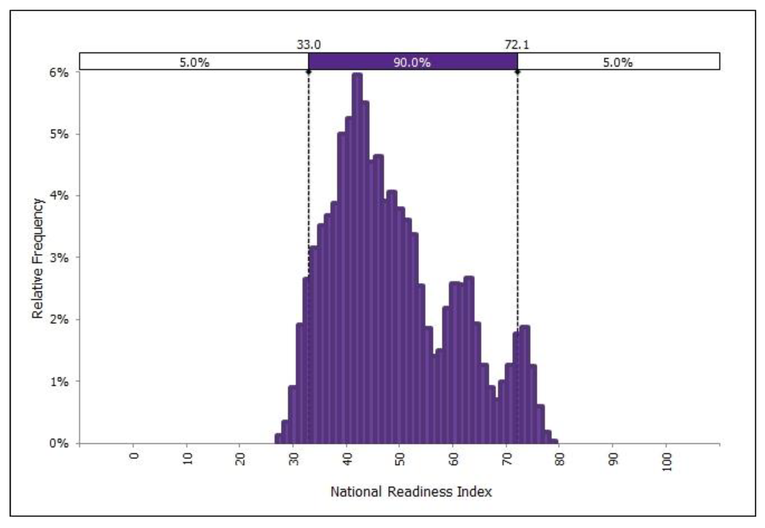
3.1. Readiness Results

The results of the analysis illustrate the current level of readiness for WildFireSat data products aggregated across Canadian fire management agencies. The Collective Readiness Component Indices for all components are shown in Figure 3 and are expressed on a relative frequency scale, with the thickest part of the distribution corresponding to the most common histogram values calculated for the Collective Readiness Component Index. The figure suggests that some agencies are more ready than others, regardless of readiness component. Collectively, the studied agencies appear to be more ready in terms of IMIT, while somewhat less prepared when it comes to organization and understanding. Given that most agencies have IMIT systems that serve existing conventional fire management purposes, this makes sense (e.g., creating, ingesting, and displaying fire data such as suppression asset tracking, fire points and polygons, and weather and hazard forecasts). There are also IMIT and Geospatial Working Groups at CIFFC, where all agencies in Canada coordinate towards data sharing and common practices. However, there is no similar community of practice for remote sensing for fire management in Canada, which may contribute to lower levels of understanding and organizational readiness.
Figure 4a–c illustrates the relative distance between the current state of readiness of the collective fire management agencies and the theoretical maximum index achievable in the model, as represented by the hypothetically-ready agency scores. Note that the distribution of the hypothetical agency scores fails to overlap with the distribution of the Collective Readiness Component Indices, for any component. This indicates that, in general, nationally, there is room for improvement in readiness for WildFireSat. Figure 3 and Figure 4 indicate that most of the agencies are grouped between the 40 and 50 index values, although a second index peak occurs between the 70 and 80 index values for each component.
Figure 5 illustrates the distribution of the National Readiness Index histogram, capturing the minimum of the three Agency Readiness Component Indices over all agencies. This trimodal distribution implies a large concentration of minimum indexes around 40, and somewhat smaller clusters of indexes around 60 and 75. These results suggest that the majority of agencies are moderately (i.e., about 50%, on a 1–100 scale) ready for WildFireSat, based on our definition of readiness and assumption that the minimum Readiness Component Index reflects overall agency readiness. A smaller proportion of agencies appear to have a higher level of readiness (60–75% ready).
Although these results are subjective (e.g., indicator scoring, weighting, choice of minimum component index), they do suggest that all Canadian fire management agencies have some level of readiness for WildFireSat data products. The figure is conservative, given that it reflects the minimum across all readiness components for each agency; the indexes for the readiness components not reflected in the figure can be quite high.

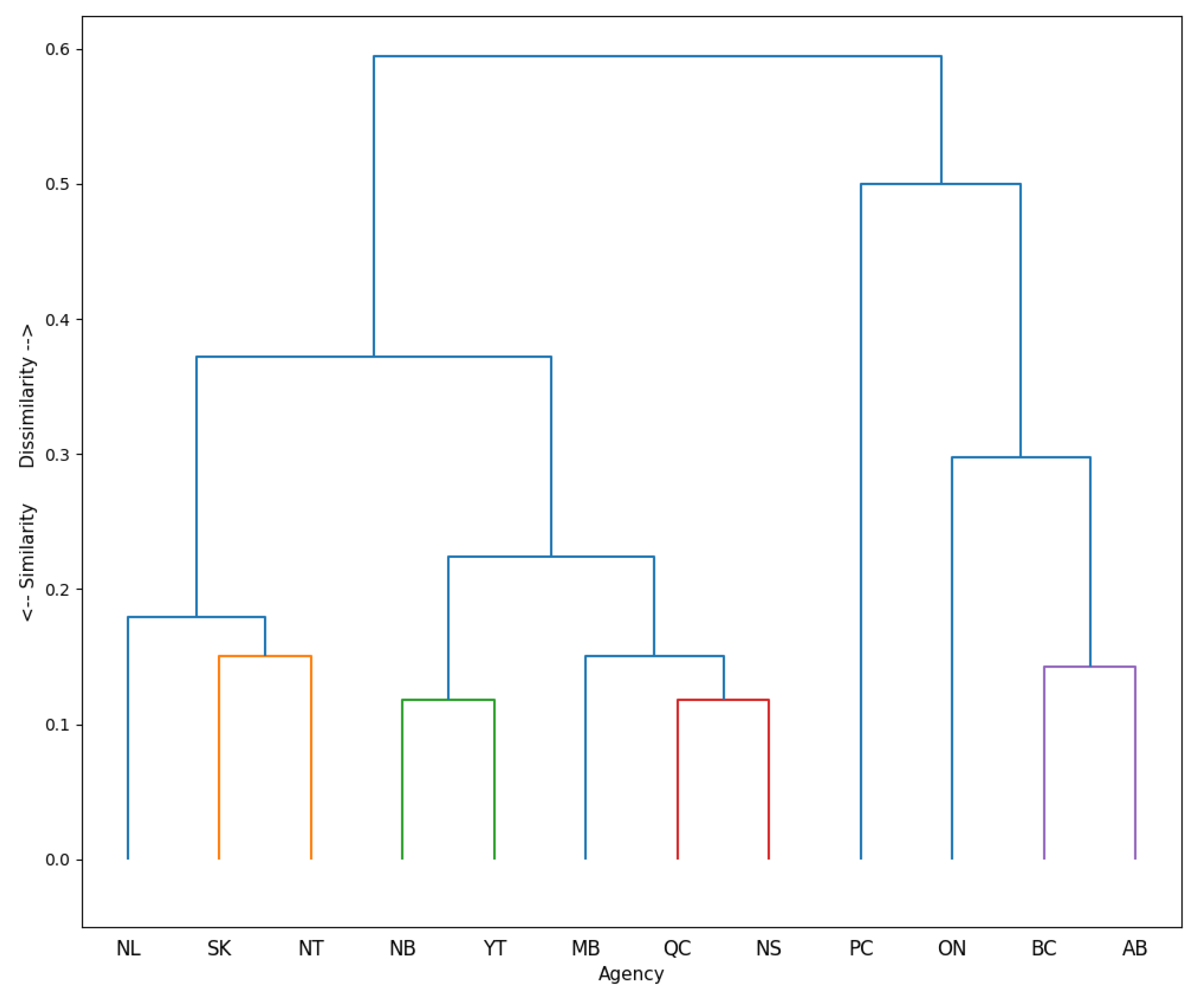
3.2. Agency Similarity Results

Using the data from all of the indicators (Table 1 and Table 2), not accounting for uncertainty, we first looked for natural groupings of fire management agencies based on their similarity, as depicted in Figure 6. The height of the first merge in the dendrogram (Figure 6) indicates relatively low similarity overall. This is not an unexpected result given the wide range of indicators. However, when we look at sub-sets of indicators, more similarities become evident. For example, indicators that are specific to agency partnerships in delivery and development are shown in Figure 7, and indicators that are specific to agency familiarization with remote sensing are also shown in Figure 8. We see more similarities in the clusters for these sub-sets relative to the overall clustering of all indicators in Figure 6.
The results of the clustering on the sub-sets of indicators can be used to consider where fire management agencies with similar attributes, in certain areas, could work together on the joint strategies described in the next section. Dendrograms for the remaining themes of indicator data are detailed in Supplementary Materials S3.

4. Discussion

4.1. Strategies and Activities That May Increase Readiness

General strategies to increase readiness for WildFireSat which we inferred from the survey responses include: increasing education and training in remote sensing and for the interpretation of fire intelligence for decision-making; increasing expertise within agencies and within the broader fire management community; fostering active communication between the development team and fire management community in the design and development of WildFireSat products; alignment and compatibility of information management and technology with the fire management agencies requirements; increasing the capacity for implementation. Table 3 provides an example of a strategy with potential activities that could be used to increase readiness. Selected supporting quotes from the survey responses are also provided. For a detailed list of Strategies, activities, and selected supporting quotes, see Supplementary Material S4.

4.2. Applications

These results can be used to support approaches to increase readiness for WildFireSat. Indeed, Ford and King [43] highlight the benefits of using adaptation readiness evaluations to guide future research and policy design, ensuring that readiness efforts are targeted, appropriate, and ultimately successful. The National Readiness Index can be used to inform and support high-level policy direction and strategic approaches to support the implementation of WildFireSat; for example, initiatives to increase capacity within provincial and territorial fire management agencies to integrate, understand, and better use WildFireSat products in real world decision-making. Agency consultations may help to inform areas of focus and potential activities for WildFireSat preparation. It is important to note that each fire management agency is responsible for its adaptation and change processes. Our hope is that these assessments will encourage collaborations and support these processes.
Other initiatives to assess fire management innovation readiness in Canada could use a similar approach, although it may not be appropriate in other jurisdictions. Most fire management agencies in Canada have explicitly worked together for decades and have significant similarities [60] that we feel allow for a straightforward assessment of readiness with a common approach. Variation across regions, organizations, and operational challenges likely precludes the use of the same readiness indicators elsewhere [79].
A caution regarding the application of the results is that the indicators should not be used prescriptively to improve agency readiness. The hypothetical ready agency should similarly not be used as a model to emulate. For example, the model assumes that agencies with greater fire activity have developed capacity in understanding, organization, and IMIT components in response to that increased activity. It would be nonsensical to suggest that an agency promote increased fire activity in support of WildFireSat readiness. It is more important to consider the overall state of any Readiness Component and the strategies that could be used to increase readiness to a degree determined by the fire management agency.

4.3. Limitations

This approach is not without limitations. There are other aspects of readiness which may not be captured here, and we could be missing important indicators. Additionally, actual readiness needs may be greater than (or less than) the results reported here. Nevertheless, our approach has produced a representative assessment that reflects data elicited from fire management experts.
Changes to our subjective scoring, rating, and weighting may result in different responses. By including measures of uncertainty within the model, we have attempted to mitigate the effect of incorrect subjective assessments. Inaccuracies related to the interpretation of text survey responses and any issues that might exist with agency selection of appropriate subject matter experts to provide survey responses [61] have been addressed via varying indicator scores. Incorporating variable contribution weights also captures some of the subjectivity associated with assigning representative values.
There are other limitations that cannot be accounted for within our current modelling approach. Our assessment represents a snapshot in time and does not measure temporal readiness (Ford and King [43] note similar limitations), nor does it address any advancements in readiness that have occurred since survey responses were collected, possibly as a result of participating in the survey and engagements. Future work in this area could address some of these limitations by periodically surveying agencies, and evaluating changes in readiness over time and preparations made in advance of WildFireSat.

4.4. Validation

Judging the suitability of this approach and results is complex. Therefore, similarly to the model itself, we rely on expert judgment to assess the usefulness of the results [63]. The results for each fire management agency were prepared and provided for their independent assessment and use. The feedback received was favourable and generally agreed with the results. This supports the approach and inferences we draw for a national perspective on readiness. The inclusion of practitioners in the modelling process has been identified in other fire-centric studies as important for users gaining trust and adoption of the results [35,80]; therefore, we expect favourable acceptance of the approach and results.

5. Conclusions

The forthcoming data products from WildFireSat are anticipated to be transformational for operational wildfire situational awareness and decision-making in Canada. WildFireSat will provide unprecedented, daily, and near real-time strategic intelligence on all active wildfires, at a scale and scope previously not possible, timed for agencies’ need to make critical decisions. Air quality, smoke, and carbon emissions from wildfires will also be better forecasted and monitored in near real time.
Incremental changes and especially transformational changes take time, effort, and knowledge. There is a time-limited opportunity before launch during which agencies can prepare in advance, and therefore be ready to fully benefit much more rapidly from WildFireSat products. The results from this analysis indicated gaps in understanding, organizational adaptability, and IMIT agility that can be addressed to facilitate agency changes. The strategies identified through the engagement can inform actions to close the gaps. Furthermore, the identified similarities and differences between agencies can be used advantageously to guide the formation of collaborations between agencies. That is, agencies with common gaps can work together and learn from agencies with complementary strengths.
Beyond WildFireSat, we believe that our methods can be applied to expedite the adoption of other science and technology innovations for fire management. The indicators and readiness components would of course require modification to the particular application; however, the overall approach would be beneficial.

Supplementary Materials

The following supporting information can be downloaded at: https://www.mdpi.com/article/10.3390/fire6020073/s1, S1: The Survey Engagement; S2: Readiness Indicator Narratives; S3: Clustering Method and Results; S4: WildFireSat Strategies and Activities to Increase Readiness.

Author Contributions

Conceptualization, C.B.M., E.S.H., D.B., L.M.J., A.R. and J.M.J.; Data curation, C.B.M., L.M.J. and M.S.; Formal analysis, C.B.M., E.S.H., D.B., A.R. and M.C.; Investigation, C.B.M., E.S.H., D.B., L.M.J., A.R., M.C., M.S., A.S.C. and J.M.J.; Methodology, C.B.M., E.S.H., D.B., A.R., M.S. and A.S.C.; Project administration, C.B.M., A.S.C. and J.M.J.; Resources, C.B.M., A.S.C. and J.M.J.; Software, C.B.M., E.S.H., D.B. and A.R.; Visualization, C.B.M., E.S.H., D.B. and A.R.; Writing—original draft, C.B.M., E.S.H., D.B., L.M.J., A.R., M.S., A.S.C. and T.J.L.; Writing—review & editing, C.B.M., E.S.H., D.B., L.M.J., A.R., M.C., M.S., A.S.C., J.M.J. and T.J.L. All authors have read and agreed to the published version of the manuscript.

Funding

This research received no external funding.

Institutional Review Board Statement

Not applicable.

Informed Consent Statement

Data was collected from fire management agencies following appropriate process for the respective agency. Data was collected representing the agency as an official response not an individual. To respect fire management agency polices regarding data, a data collection protocol was established and participation by an agency was stipulated as voluntarily, with explicit and informed consent with data anonymized for publication.

Data Availability Statement

Due to the nature of the data collection protocol, data is not available.

Acknowledgments

We thank the Canadian Interagency Forest Fire Centre Management Committee for supporting the WildFireSat Fire Management Knowledge Exchange Team and circulating the survey. We appreciate each fire management agency and their staff for participating in the survey. We also thank Denis Dufour of the Canadian Space Agency for assistance. This study would not have been possible without support from the WildFireSat Fire Management Knowledge Exchange Team (agency, name); Yukon, Mike Smith; Ontario, Darren McLarty; Northwest Territories, Matthew Coyle; Nova Scotia, James MacKinnon; British Columbia, Neal McLoughlin and Ashlin Richardson; Saskatchewan, Chris Dallyn; Alberta, Dave Schroeder; New Brunswick, Tony Cole; Quebec, Milène Beaudoin and Olivier Lundqvist; Manitoba, Garth Hoeppner; Newfoundland and Labrador, Jeff Motty; Parks Canada, Gregg Walker and Emma Zerr, The Department of National Defence—Canadian Forces Fire Marshal, Rick Dunning.

Conflicts of Interest

The authors declare no conflict of interest.

References

  1. Wein, R.W.; MacLean, D.A. The Role of Fire in Northern Circumpolar Ecosystems; John Wiley and Sons: Hoboken, NJ, USA, 1983. [Google Scholar]
  2. MNP. A Review of the 2016 Horse River Wildfire; MNP LLP, Alberta Agriculture and Forestry Preparedness and Response: Edmonton, AB, Canada, 2017; 92p, Available online: https://wildfire.alberta.ca/resources/reviews/2016-wildfire-review.aspx (accessed on 1 December 2022).
  3. Cruz, M.; Sullivan, A.; Gould, J.; Sims, N.; Bannister, A.; Hollis, J.; Hurley, R. Anatomy of a catastrophic wildfire: The Black Saturday Kilmore East fire in Victoria, Australia. For. Ecol. Manag. 2012, 284, 269–285. [Google Scholar] [CrossRef]
  4. Coogan, S.C.; Robinne, F.-N.; Jain, P.; Flannigan, M. Scientists’ warning on wildfire—A Canadian perspective. Can. J. For. Res. 2019, 49, 1015–1023. [Google Scholar] [CrossRef] [Green Version]
  5. Flannigan, M.D.; Amiro, B.D.; Logan, K.A.; Stocks, B.J.; Wotton, B.M. Forest Fires and Climate Change in the 21st Century. Mitig. Adapt. Strat. Glob. Chang. 2005, 11, 847–859. [Google Scholar] [CrossRef]
  6. Flannigan, M.D.; Krawchuk, M.A.; De Groot, W.J.; Wotton, B.M.; Gowman, L.M. Implications of changing climate for global wildland fire. Int. J. Wildland Fire 2009, 18, 483–507. [Google Scholar] [CrossRef]
  7. Coogan, S.C.P.; Cai, X.; Jain, P.; Flannigan, M. Seasonality and trends in human- and lightning-caused wildfires ≥ 2 ha in Canada, 1959–2018. Int. J. Wildland Fire 2020, 29, 473–485. [Google Scholar] [CrossRef]
  8. Wotton, B.M.; Nock, C.A.; Flannigan, M.D. Forest fire occurrence and climate change in Canada. Int. J. Wildland Fire 2010, 19, 253–271. [Google Scholar] [CrossRef]
  9. Flannigan, M.; Stocks, B.; Wotton, B. Climate change and forest fires. Sci. Total Environ. 2000, 262, 221–229. [Google Scholar] [CrossRef]
  10. Wotton, B.M.; Flannigan, M.; Marshall, A.G. Potential climate change impacts on fire intensity and key wildfire suppression thresholds in Canada. Environ. Res. Lett. 2017, 12, 095003. [Google Scholar] [CrossRef]
  11. Jain, P.; Wang, X.; Flannigan, M.D. Trend analysis of fire season length and extreme fire weather in North America between 1979 and 2015. Int. J. Wildland Fire 2017, 26, 1009–1020. [Google Scholar] [CrossRef]
  12. Wotton, B.M.; Flannigan, M.D. Length of the fire season in a changing climate. For. Chron. 1993, 69, 187–192. [Google Scholar] [CrossRef] [Green Version]
  13. Gaur, A.; Bénichou, N.; Armstrong, M.; Hill, F. Potential future changes in wildfire weather and behavior around 11 Canadian cities. Urban Clim. 2021, 35, 100735. [Google Scholar] [CrossRef]
  14. Hanes, C.; Wang, X.; Jain, P.; Parisien, M.-A.; Little, J.M.; Flannigan, M.D. Fire-regime changes in Canada over the last half century. Can. J. For. Res. 2019, 49, 256–269. [Google Scholar] [CrossRef]
  15. Hope, E.S.; McKenney, D.W.; Pedlar, J.H.; Stocks, B.J.; Gauthier, S. Wildfire Suppression Costs for Canada under a Changing Climate. PLoS ONE 2016, 11, e0157425. [Google Scholar] [CrossRef] [PubMed] [Green Version]
  16. Paveglio, T.B.; Brenkert-Smith, H.; Hall, T.; Smith, A.M.S. Understanding social impact from wildfires: Advancing means for assessment. Int. J. Wildland Fire 2015, 24, 212–224. [Google Scholar] [CrossRef]
  17. Hoffman, K.M.; Christianson, A.C.; Gray, R.W.; Daniels, L. Western Canada’s new wildfire reality needs a new approach to fire management. Environ. Res. Lett. 2022, 17, 061001. [Google Scholar] [CrossRef]
  18. Johnston, L.M.; Wang, X.; Erni, S.; Taylor, S.W.; Mcfayden, C.B.; Oliver, J.A.; Stockdale, C.; Christianson, A.; Boulanger, Y.; Gauthier, S.; et al. Wildland fire risk research in Canada. Environ. Rev. 2020, 28, 164–186. [Google Scholar] [CrossRef]
  19. Zimmerman, T. Wildland fire management decision making. J. Agric. Sci. Technol. 2012, 2, 169–178. [Google Scholar]
  20. Boychuk, D.; McFayden, C.B.; Evens, J.; Shields, J.; Stacey, A.; Woolford, D.G.; Wotton, M.; Johnston, D.; Leonard, D.; McLarty, D. Assembling and Customizing Multiple Fire Weather Forecasts for Burn Probability and Other Fire Management Applications in Ontario, Canada. Fire 2020, 3, 16. [Google Scholar] [CrossRef]
  21. Martell, D.L. A Review of Recent Forest and Wildland Fire Management Decision Support Systems Research. Curr. For. Rep. 2015, 1, 128–137. [Google Scholar] [CrossRef] [Green Version]
  22. McLennan, J.; Holgate, A.M.; Omodei, M.M.; Wearing, A.J. Decision Making Effectiveness in Wildfire Incident Management Teams. J. Conting. Crisis Manag. 2006, 14, 27–37. [Google Scholar] [CrossRef]
  23. Johnston, J.M.; Jackson, N.; Mcfayden, C.; Phong, L.N.; Lawrence, B.; Davignon, D.; Wooster, M.J.; Van Mierlo, H.; Thompson, D.K.; Cantin, A.S.; et al. Development of the User Requirements for the Canadian WildFireSat Satellite Mission. Sensors 2020, 20, 5081. [Google Scholar] [CrossRef] [PubMed]
  24. Thompson, M.P.; Calkin, D.E. Uncertainty and risk in wildland fire management: A review. J. Environ. Manag. 2011, 92, 1895–1909. [Google Scholar] [CrossRef] [PubMed]
  25. Lipshitz, R.; Strauss, O. Coping with Uncertainty: A Naturalistic Decision-Making Analysis. Organ. Behav. Hum. Decis. Processes 1997, 69, 149–163. [Google Scholar] [CrossRef]
  26. KPMG. May 2016 Wood Buffalo Wildfire Post-Incident Assessment Report. 2017. Available online: https://open.alberta.ca/publications/may-2016-wood-buffalo-wildfire-post-incident-assessment-report (accessed on 10 February 2023).
  27. Rapp, C.; Rabung, E.; Wilson, R.; Toman, E. Wildfire decision support tools: An exploratory study of use in the United States. Int. J. Wildland Fire 2020, 29, 581–594. [Google Scholar] [CrossRef]
  28. Government of Canada. WildFireSat: Enhancing Canada’s Ability to Manage Wildfires. Canadian Space Agency. 2022. Available online: https://www.asc-csa.gc.ca/eng/satellites/wildfiresat/ (accessed on 1 December 2022).
  29. Government of Canada. WildFireSat Mission Requirements Document, Rev. A; Canadian Space Agency: Ottawa, ON, Canada, 2022.
  30. Wooster, M.J.; Roberts, G.J.; Giglio, L.; Roy, D.P.; Freeborn, P.H.; Boschetti, L.; Justice, C.; Ichoku, C.; Schroeder, W.; Davies, D.; et al. Satellite remote sensing of active fires: History and current status, applications and future requirements. Remote Sens. Environ. 2021, 267, 112694. [Google Scholar] [CrossRef]
  31. Land Processes Distributed Active Archive Center (LP DAAC). Aqua MODIS Acquisition Plan Through August 2026. USGS. (10 November 2021). Available online: https://lpdaac.usgs.gov/news/aqua-modis-acquisition-plan-through-august-2026/ (accessed on 1 December 2022).
  32. MODIS Characterization Support Team (MCST). Terra/MODIS Prepares for Constellation Exit. NASA. (20 September 2022). Available online: https://mcst.gsfc.nasa.gov/news/terramodis-prepares-constellation-exit. (accessed on 1 December 2022).
  33. Ramsay, B.; Flett, D.; Andersen, H.S.; Gill, R.; Nghiem, S.; Bertoia, C. Preparation for the operational use of RADARSAT-2 for ice monitoring. Can. J. Remote Sens. 2004, 30, 415–423. [Google Scholar] [CrossRef]
  34. Arkett, M.; Braithwaite, L.; Pestieau, P.; Carrieres, T.; Pogson, L.; Fabi, C.; Geldsetzer, T. Preparation by the Canadian Ice Service for the Operational Use of the RADARSAT Constellation Mission in their Ice and Oil Spill Monitoring Programs. Can. J. Remote Sens. 2015, 41, 380–389. [Google Scholar] [CrossRef]
  35. McFayden, C.B.; George, C.; Johnston, L.M.; Wotton, M.; Johnston, D.; Sloane, M.; Johnston, J.M. A case-study ofwildland fire management knowledge exchange: The barriers and facilitators in the development and integration of the Canadian Forest Fire Danger Rating System in Ontario, Canada. Int. J. Wildland Fire 2022, 31, 835–846. [Google Scholar] [CrossRef]
  36. Rafferty, A.E.; Jimmieson, N.; Armenakis, A.A. Change Readiness. J. Manag. 2013, 39, 110–135. [Google Scholar] [CrossRef] [Green Version]
  37. Sankey, S. Blueprint for Wildland Fire Science in Canada (2019–2029); Natural Resources Canada, Canadian Forest Service, Northern Forestry Centre: Edmonton, AB, Canada, 2018; Available online: http://cfs.nrcan.gc.ca/publications?id=39429 (accessed on 10 February 2023).
  38. Canadian Council of Forest Ministers. Canadian Wildland Fire Strategy: A 10-Year Review and Renewed Call to Action; Natural Resources Canada: Ottawa, ON, Canada, 2016; ISBN 978-0-660-05656-2. Available online: https://www.ccfm.org/releases/canadian-wildland-fire-strategy-a-10-year-review-and-renewed-call-to-action/ (accessed on 10 February 2023).
  39. Canadian Council of Forest Ministers. Canadian Council of Forest Ministers Wildland Fire Management Working Group—Action Plan 2021–2026; Natural Resources Canada: Ottawa, ON, Canada, 2021; ISBN 978-0-660-39184-7. Available online: https://www.ccfm.org/releases/wildland-fire-management-working-group-action-plan-2021-2026/ (accessed on 10 February 2023).
  40. Worley, C.G.; Lawler, E.E. Building a Change Capability at Capital One Financial. Organ. Dyn. 2009, 38, 245–251. [Google Scholar] [CrossRef]
  41. Armenakis, A.A.; Harris, S.G.; Mossholder, K. Creating Readiness for Organizational Change. Hum. Relat. 1993, 46, 681–703. [Google Scholar] [CrossRef]
  42. Lokuge, S.; Sedera, D.; Grover, V.; Dongming, X. Organizational readiness for digital innovation: Development and empirical calibration of a construct. Inf. Manag. 2019, 56, 445–461. [Google Scholar] [CrossRef]
  43. Ford, J.D.; King, D. A framework for examining adaptation readiness. Mitig. Adapt. Strat. Glob. Chang. 2015, 20, 505–526. [Google Scholar] [CrossRef]
  44. McFayden, C.B.; Johnston, L.M.; Woolford, D.G.; George, C.; Johnston, D.; Boychuk, D.; Wotton, B.M.; Johnston, J.M. A Conceptual Framework for Knowledge Exchange in a Wildland Fire Research and Practice Context. In Applied Data Science: Data Translators Across the Disciplines; Woolford, D., Kotsopoulos, D., Samuels, B., Eds.; Springer, Interdisciplinary Applied Sciences: London, UK, in press.
  45. Gopalakrishnan, S.; Santoro, M. Distinguishing Between Knowledge Transfer and Technology Transfer Activities: The Role of Key Organizational Factors. IEEE Trans. Eng. Manag. 2004, 51, 57–69. [Google Scholar] [CrossRef]
  46. Yusif, S.; Hafeez-Baig, A.; Soar, J. e-Health readiness assessment factors and measuring tools: A systematic review. Int. J. Med. Inform. 2017, 107, 56–64. [Google Scholar] [CrossRef] [PubMed]
  47. Digman, L.A. Organizational factors related to technology transfer and innovation. J. Technol. Transf. 1977, 2, 61–68. [Google Scholar] [CrossRef]
  48. Goodman, S.J.; Gurka, J.; DeMaria, M.; Schmit, T.J.; Mostek, A.; Jedlovec, G.; Siewert, C.; Feltz, W.; Gerth, J.; Brummer, R.; et al. The GOES-R Proving Ground: Accelerating User Readiness for the Next-Generation Geostationary Environmental Satellite System. Bull. Am. Meteorol. Soc. 2012, 93, 1029–1040. [Google Scholar] [CrossRef] [Green Version]
  49. Hossain, F.; Srinivasan, M.; Peterson, C.; Andral, A.; Beighley, E.; Anderson, E.; Amini, R.; Birkett, C.; Bjerklie, D.; Blain, C.A.; et al. Engaging the User Community for Advancing Societal Applications of the Surface Water Ocean Topography Mission. Bull. Am. Meteorol. Soc. 2017, 98, ES285–ES290. [Google Scholar] [CrossRef] [Green Version]
  50. Lalonde, S.J.; Mach, K.J.; Anderson, C.M.; Francis, E.J.; Sanchez, D.L.; Stanton, C.Y.; Turner, P.A.; Field, C.B. Forest management in the Sierra Nevada provides limited carbon storage potential: An expert elicitation. Ecosphere 2018, 9, e02321. [Google Scholar] [CrossRef] [Green Version]
  51. Fried, J.S.; Gilless, J.K. Expert opinion estimation of fireline production rates. For. Sci. 1989, 35, 870–877. [Google Scholar] [CrossRef]
  52. Hirsch, K.G.; Corey, P.N.; Martell, D.L. Using expert judgment to model initial attack fire crew effectiveness. For. Sci. 1998, 44, 539–549. [Google Scholar] [CrossRef]
  53. Miller, C.; Landres, P. Exploring Information Needs for Wildland Fire and Fuels Management; RMRS-GTR-127; Department of Agriculture, Forest Service, Rocky Mountain Research Station: Fort Collins, CO, USA, 2004; 36p. [Google Scholar] [CrossRef]
  54. Mcfayden, C.B.; Boychuk, D.; Woolford, D.G.; Wheatley, M.J.; Johnston, L. Impacts of wildland fire effects on resources and assets through expert elicitation to support fire response decisions. Int. J. Wildland Fire 2019, 28, 885–900. [Google Scholar] [CrossRef]
  55. Thompson, M.P.; Scott, J.; Helmbrecht, D.; Calkin, E.D. Integrated wildfire risk assessment: Framework development and application on the Lewis and Clark National Forest in Montana, USA. Integr. Environ. Assess. Manag. 2013, 9, 329–342. [Google Scholar] [CrossRef] [PubMed]
  56. Venn, T.J.; Calkin, D.E. Accommodating non-market values in evaluation of wildfire management in the United States: Challenges and opportunities. Int. J. Wildland Fire 2011, 20, 327–339. [Google Scholar] [CrossRef]
  57. Canadian Council of Forest Ministers. Canadian Dialog on Wildland Fire and Forest Resilience—What We Heard Report; Natural Resources Canada: Ottawa, ON, Canada, 2022; ISBN 978-0-660-43722-4. Available online: https://www.ccfm.org/releases/canadian-dialogue-on-wildland-fire-and-forest-resilience-what-we-heard-report-spring-2022/ (accessed on 10 February 2023).
  58. Gordon, G. Developing More Common Language, Terminology and Data Standards for Wildland Fire Management in Canada; Canadian Forest Fire Interagency Centre: Winnipeg, MB, Canada, 2014; 45p, Available online: https://www.ciffc.ca/sites/default/files/2019-03/Developing_More_Common_Terminolgy_-_Final_Report.pdf (accessed on 10 February 2023).
  59. Gordon, G. Workforce Demographic Issues in Canada’s Wildland Fire Management Agencies; Canadian Forest Fire Interagency Centre: Winnipeg, MB, Canada, 2014; 51p, Available online: https://ciffc.ca/sites/default/files/2019-03/Workforce_Demographic_Issues_-_Final_2.pdf (accessed on 10 February 2023).
  60. Tymstra, C.; Stocks, B.J.; Cai, X.; Flannigan, M.D. Wildfire management in Canada: Review, challenges and opportunities. Prog. Disaster Sci. 2020, 5, 100045. [Google Scholar] [CrossRef]
  61. Knol, A.B.; Slottje, P.; Van Der Sluijs, J.P.; Lebret, E. The use of expert elicitation in environmental health impact assessment: A seven step procedure. Environ. Health 2010, 9, 19. [Google Scholar] [CrossRef] [Green Version]
  62. Hardy, C.C. Wildland fire hazard and risk: Problems, definitions, and context. For. Ecol. Manag. 2005, 211, 73–82. [Google Scholar] [CrossRef]
  63. Cambridge University Press. Readiness. Cambridge Dictionary. Available online: https://dictionary.cambridge.org/dictionary/english/readiness (accessed on 1 December 2022).
  64. Canadian Interagency Forest Fire Centre (CIFFC). Glossary of Forest Fire Management Terms; Canadian Interagency Forest Fire Centre: Winnipeg, MB, Canada, 2022; Available online: https://www.ciffc.ca/publications/glossary (accessed on 20 October 2022).
  65. Landry, M.; Malouin, J.L.; Oral, M. Model validation in operations research. Eur. J. Oper. Res. 1983, 14, 207–220. [Google Scholar] [CrossRef]
  66. Canadian Interagency Forest Fire Centre (CIFFC). Directory of Wildland Fire Management Personnel; Canadian Interagency Forest Fire Centre: Winnipeg, MB, Canada, 2022; Available online: https://www.ciffc.ca/sites/default/files/2022-04/Directory_2022_04_01_1.pdf (accessed on 23 January 2022).
  67. Winship, C.; Mare, R.D. Models for Sample Selection Bias. Annu. Rev. Soc. 1992, 18, 327–350. [Google Scholar] [CrossRef]
  68. Roux, D.J.; Rogers, K.H.; Biggs, H.C.; Ashton, P.J.; Sergeant, A. Bridging the Science–Management Divide: Moving from Unidirectional Knowledge Transfer to Knowledge Interfacing and Sharing. Ecol. Soc. 2006, 11, 4. [Google Scholar] [CrossRef] [Green Version]
  69. Canadian Forest Service (CFS). Canadian National Fire Database—Agency Fire Data; Natural Resources Canada, Canadian Forest Service, Northern Forestry Centre: Edmonton, AB, Canada; Available online: https://cwfis.cfs.nrcan.gc.ca/ha/nfdb (accessed on 12 October 2022).
  70. Public Safety Canada. The Canadian Disaster Database; Government of Canada: Ottawa, ON, Canada, 2022; Available online: https://www.publicsafety.gc.ca/cnt/rsrcs/cndn-dsstr-dtbs/index-en.aspx (accessed on 10 February 2023).
  71. Canadian Forest Service (CFS). Evacuation Dataset. Internal Data; Canadian Forest Service: Ottawa, ON, Canada, 2021. [Google Scholar]
  72. Canadian Interagency Forest Fire Centre (CIFFC). Canadian Fire Costs 2019. Internal Data; Canadian Interagency Forest Fire Centre: Winnipeg, MB, Canada, 2020. [Google Scholar]
  73. Statistics Canada. Consumer Price Index, Annual Average, not Seasonally Adjusted. Table 18-10-0005-01; Government of Canada: Ottawa, ON, Canada, 2022; Available online: https://www150.statcan.gc.ca/t1/tbl1/en/tv.action?pid=1810000501&pickMembers%5B0%5D=1.2&cubeTimeFrame.startYear=2000&cubeTimeFrame.endYear=2019&referencePeriods=20000101%2C20190101 (accessed on 10 February 2023).
  74. Weber, E.U.; Hilton, D.J. Contextual effects in the interpretations of probability words: Perceived base rate and severity of events. J. Exp. Psychol. Hum. Percept. Perform. 1990, 16, 781–789. [Google Scholar] [CrossRef]
  75. Vose, D. Risk Analysis, A Quantitative Guide; John Wiley & Sons Ltd.: Hoboken, NJ, USA, 2000. [Google Scholar]
  76. Day, W.H.E.; Edelsbrunner, H. Efficient algorithms for agglomerative hierarchical clustering methods. J. Classif. 1984, 1, 7–24. [Google Scholar] [CrossRef]
  77. Sneath, P.H.; Sokal, R. Numerical Taxonomy; W. H. Freeman and Company: New York, NY, USA, 1973. [Google Scholar]
  78. Dixon, J.K. Pattern Recognition with Partly Missing Data. IEEE Trans. Syst. Man Cybern. 1979, 9, 617–621. [Google Scholar] [CrossRef]
  79. Atayero, A.A.; Oluwatobi, S.O.; Alege, P.O. An Assessment of the Internet of Things (IoT) Adoption Readiness of Sub-Saharan Africa. J. S. Afr. Bus. Res. 2016, 13, 1–13. [Google Scholar] [CrossRef] [Green Version]
  80. Woolford, D.G.; Martell, D.L.; McFayden, C.B.; Evens, J.; Stacey, A.; Wotton, B.M.; Boychuk, D. The development and implementation of a human-caused wildland fire occurrence prediction system for the province of Ontario, Canada. Can. J. For. Res. 2021, 51, 303–325. [Google Scholar] [CrossRef]
Figure 1. Overview of the formal readiness model. Survey responses, and agency workload and activity data were scored for use as indicators of three components of readiness. The indicators were assigned weights according to their contributions to each component. The products of Indicator Scores and Contribution Weights were summed to produce Readiness Component Indices, each rescaled from 0 to 100. The Readiness Index is derived from the Readiness Component Indices.
Fire 06 00073 g001
Figure 2. Model input distributions, representing five levels of confidence rating identified as appropriate by subject-matter experts, for an indicator score of 6 and varying levels of confidence around that scoring. Note that the distribution for the 93% confidence (thin, solid line) is most likely to produce a value of 6; although other values (1–10) are possible, they are less likely and are clustered around 6. The distribution for the 5% confidence (thick, dashed line) can produce a value between 0 and 10 with relatively equal likelihood, although lower (0–3) and higher values (8–10) are lightly less likely. (b) Model input distributions for an indicator score of 9 and varying levels of confidence around that scoring are likely, (a) although they are left-skewed, i.e., with longer tails to the left and clustering to the right.
Fire 06 00073 g002
Figure 3. Collective Readiness Component Index, a histogram of the Agency Readiness Component Indices.
Fire 06 00073 g003
Figure 4. Readiness component index distributions of the collective fire management agencies with the theoretical ready agency scores: (a) Understanding, (b) Organization, and (c) IMIT.
Fire 06 00073 g004
Figure 5. National Readiness Index, across all agencies across all components. This index is constrained by the minimum agency readiness component of each agency over all agencies.
Fire 06 00073 g005
Figure 6. Dendrogram illustrating fire management agencies in similar clusters considering all indicators in the study. Agencies that are clustered first, starting from the bottom of the plot moving upward, are most similar. For example, we see that see that MB and NS are the most similar in terms of overall coded responses (they group first). Next, NB joins with MB and NS. Later, YT and NT are grouped since they are approximately as similar to each other as NB is to MB and NS.
Fire 06 00073 g006
Figure 7. Dendrogram illustrating fire management agencies in similar clusters considering only indicators from agency partnerships in delivery and development. We see that QC and NS merge first (in red), next, NB and YT (in green), BC and AB (in purple), SK and NT (in orange), and so forth.
Fire 06 00073 g007
Figure 8. Dendrogram illustrating fire management agencies in similar clusters considering only indicators from agency familiarization with remote sensing data. We see that ON and NT are the most similar, then NS and YT (in green). In the orange group, SK and QC join first, then AB is added, followed by PC, and so forth.
Fire 06 00073 g008
Table 1. Quantitative indicators of readiness from available datasets on agency workload and activities.
1Official duration of the fire season a [60]220 years median annual number of fires (2002–2021) [69]
3Ratio of 95th percentile and median annual number of fires [69] 420 years median annual area burned (2002–2021) [69]
5Ratio of 95th percentile and medial annual area burned [69]610 years number of wildfire disasters (2012–2021) [70]
710 yr. number of evacuation events (2012–2021) [71]810 years median fixed costs, adjusted to 2019 dollars (2008–2017) b,c [72]
9Relative average change of fixed costs (trend) adjusted to 2019 dollars (2008–2017) b,c
a Parks Canada and British Columbia do not have defined dates [60] and the maximum duration of the Provinces and Territories was used. b Agency cost data represent 2008–2017, adjusted to 2019 values with the consumer price index [73]. c Parks Canada was missing 2017 costs, therefore 2007–2016 costs were used.
Table 2. Indicators of readiness from survey responses.
10Fire suppression service partnerships 11Fire management partnerships
12Science and translation collaborative partners13Training and implementation collaborative partners
14Innovation and knowledge transfer full time equivalent positions (weighted by staff count)15Number of operational plans for preparedness and operations
16Expected type of users for WildFireSat (e.g., all levels in the organization, function specific)17Number or geospatial staff
18How knowledge of fixed wing and drone remote sensing is organized (e.g., centralized, distributed) 19Types of remote sensing platforms currently used
20Use of current space-based earth observation data21Degree of implementation of space-based earth observation data (e.g., derived products)
22Large fire mapping process sophistication 23Landscape scale situational awareness methods sophistication
24Sophistication of operating procedures for fire monitoring 25Escalation triage, the sophistication of methods and tools to prioritize fires
26Existence of policies and procedures to govern approval of fire intelligence27Degree of process to determine what intelligence can be used operationally (e.g., directed, ad-hoc)
28Frequency of use of current external intelligence sources29Complexity of process to implement new software or tool
30Potential use of WildFireSat considering agency preference for external web-based access and in-house development 31Number of agency groups or cadres to be engaged in WildFireSat preparedness
32Current use of open-source and proprietary web services33Current barriers to open-source web service use
34Current barriers to proprietary web service use35Current agency metadata standards or requirements
Table 3. Example of a strategy and corresponding activities which may increase readiness for WildFireSat.
Strategy Activities
Increasing education and training in remote sensing and for interpretation of fire intelligence for decision-making
  • Develop a range of educational materials on the types, kinds, and uses of remote sensing for operational fire management.
  • Develop accessible training courses in the fundamentals of decision-making and model interpretation to better understand and use the fire intelligence possible with WildFireSat.
  • Ensure training/education is considered as a requirement for products and delivery mechanisms developed by WildFireSat.
Would want learning opportunities (tutorials, web meeting) [to] be available to staff.”
Training opportunities to better exploit the full range of capability.”
“…training opportunities so that users can gain confidence in knowing and understanding how to use WildFireSat to its best potential.”
Clear indication of the limitations of the data and products when used for decision making.”
Disclaimer/Publisher’s Note: The statements, opinions and data contained in all publications are solely those of the individual author(s) and contributor(s) and not of MDPI and/or the editor(s). MDPI and/or the editor(s) disclaim responsibility for any injury to people or property resulting from any ideas, methods, instructions or products referred to in the content.

