


Software-Based Simulations of Wildfire Spread and Wind-Fire Interaction


Abstract
1. Introduction
2. Software on Fire Propagation Modeling
2.1. Fire Spread Simulation
2.1.1. Raster-Based Simulation
2.1.2. Huygens Wavelet Principle
2.2. Fire Behaviour Models
3. Fire Simulation Mechanisms
3.1. Available Software
3.2. Advantages and Limitations of Using Fire Software
4. Recent Improvements in Fire Dynamic Modeling and Its Impact on Structures
5. Conclusions
6. Recommendations for Future Studies
Author Contributions
Funding
Informed Consent Statement
Data Availability Statement
Conflicts of Interest
Abbreviations
| WUI | Wildfire and the wildland urban interface |
| GIS | geographic information system |
| WRF | Weather Research & Forecasting Model |
| LES | Large Eddy Simulation |
| FDS | Fire Dynamics Simulator |
| WFDS | Wildland Urban Interface Fire Dynamics Simulator |
| FEM | Finite Element Method |
| CFD | Computational fluid dynamics |
References
- Alavalapati, J.R.; Carter, D.R.; Newman, D.H. Wildland-urban interface: Challenges and opportunities. For. Policy Econ. 2005, 7, 705–708. [Google Scholar] [CrossRef]
- Evans, D.E.; Fent, K.W. Fent, Ultrafine and respirable particle exposure during vehicle fire suppression. Environ. Sci. Process. Impacts 2015, 17, 1749–1759. [Google Scholar] [CrossRef]
- Radeloff, V.C.; Helmers, D.P.; Kramer, H.A.; Stewart, S.I. Rapid growth of the US wildland-urban interface raises wildfire risk. Proc. Natl. Acad. Sci. USA 2018, 115, 3314–3319. [Google Scholar] [CrossRef] [PubMed]
- Mowery, M.; Read, M.; Johnston, K.; Wafaie, T. Planning the Wildland-Urban Interface, Report 594; Planning, Advisory Service, American Planning Association: Washington, DC, USA, 2019. [Google Scholar]
- Bowman, D.M.J.S.; Balch, J.; Artaxo, P.; Bond, W.J.; Cochrane, M.A.; D’Antonio, C.M.; DeFries, R.; Johnston, F.H.; Keeley, J.E.; Krawchuk, M.A.; et al. The human dimension of fire regimes on Earth. J. Biogeogr. 2011, 38, 2223–2236. [Google Scholar] [CrossRef]
- McAneney, J.; Chen, K.; Pitman, A. 100-years of Australian bushfire property losses: Is the risk significant and is it increasing? J. Environ. Manag. 2009, 90, 2819–2822. [Google Scholar] [CrossRef]
- Cruz, M.; Sullivan, A.; Gould, J.; Sims, N.; Bannister, A.; Hollis, J.; Hurley, R. Anatomy of a catastrophic wildfire: The Black Saturday Kilmore East fire in Victoria, Australia. For. Ecol. Manag. 2012, 284, 269–285. [Google Scholar] [CrossRef]
- Filkov, A.I.; Ngo, T.; Matthews, S.; Telfer, S.; Penman, T.D. Impact of Australia’s catastrophic 2019/20 bushfire season on communities and environment. Retrospective analysis and current trends. J. Saf. Sci. Resil. 2020, 1, 44–56. [Google Scholar] [CrossRef]
- Ronchi, E.; Nilsson, D. Fire evacuation in high-rise buildings: A review of human behaviour and modelling research. Ronchi Nilsson Fire Sci. Rev. 2013, 2, 7. [Google Scholar] [CrossRef]
- Johansson, N.; Svensson, S. Review of the Use of Fire Dynamics Theory in Fire Service Activities. Fire Technol. 2019, 55, 81–103. [Google Scholar] [CrossRef]
- Gould, J.; Mccaw, L.; Cruz, M.; Wendy, A. How good are fire behaviour models? Validation of eucalypt forest fire spread model. In Proceedings of the 5th International Wildland Fire Conference, Sun City, South Africa, 9–13 May 2011. [Google Scholar]
- Spano, E.D.; Bacciu, V.; Salis, M.; Sirca, C. Modelling Fire Behaviour and Risk, Supported by PROTERINA-C Project EU Italia-Francia Marittimo, 2007-2013 Programme; Nuova StampaColor: Sassari, Italy, 2012. [Google Scholar]
- Johnston, P.; Milne, G.; Klemitz, D. Overview of bushfire spread simulation systems. Bushfire CRC 2005, 31, 6. [Google Scholar]
- Jiang, W.; Wang, F.; Fang, L.; Zheng, X.; Qiao, X.; Li, Z.; Meng, Q. Modelling of wildland-urban interface fire spread with the heterogeneous cellular automata model. Environ. Model. Softw. 2021, 135, 104895. [Google Scholar] [CrossRef]
- Mutthulakshmi, K.; Wee, M.R.; Wong, Y.C.K.; Lai, J.W.; Koh, J.M.; Acharya, U.R.; Cheong, K.H. Simulating forest fire spread and fire-fighting using cellular automata. Chin. J. Phys. 2020, 65, 642–650. [Google Scholar] [CrossRef]
- You, J.; Huai, Y.; Nie, X.; Chen, Y. Real-time 3D visualization of forest fire spread based on tree morphology and finite state machine. Comput. Graph. 2022, 103, 109–120. [Google Scholar] [CrossRef]
- Byari, M.; Bernoussi, A.; Jellouli, O.; Ouardouz, M.; Amharref, M. Multi-scale 3D cellular automata modeling: Application to wildland fire spread. Chaos Solitons Fractals 2022, 164, 112653. [Google Scholar] [CrossRef]
- Farguell, A.; Cortés, A.; Margalef, T.; Miró, J.R.; Mercader, J. Scalability of a multi-physics system for forest fire spread prediction in multi-core platforms. J. Supercomput. 2019, 75, 1163–1174. [Google Scholar] [CrossRef]
- Lai, C.M.; Tsai, M.J.; Lin, T.H. Experimental Investigations of Fire Spread from Movable to Fixed Fire Loads in Office Fires. J. 2010, 28, 539–559. [Google Scholar] [CrossRef]
- Tyrna, B.; Assmann, A.; Fritsch, K.; Johann, G. Large-scale high-resolution pluvial flood hazard mapping using the raster-based hydrodynamic two-dimensional model FloodAreaHPC. J. Flood Risk Manag. 2018, 11, 1024–1037. [Google Scholar] [CrossRef]
- Varela, V.; Vlachogiannis, D.; Sfetsos, A. Projection of Forest Fire Danger due to Climate Change in the French Mediterranean Region. Sustainability 2019, 11, 4284. [Google Scholar] [CrossRef]
- Polinov, M.; Kutiel, H.; Wittenberg, L.; Brook, A. Connectivity as a factor of wildfire spreading across the urban area: Review, test and evaluation fire modeling approaches. Geophys. Res. Abstr. 2019, 21, EGU2019-574-2. [Google Scholar]
- Vasconcelos, M.; Guertin, D. FIREMAP—Simulation of fire growth with a geographic information system. Int. J. Wildland Fire 1992, 2, 87–96. [Google Scholar] [CrossRef]
- Karani, J.; Sichangi, A.W.; Gachari, M.K. Forest Fire Monitoring using GIS: Case Study of Mt. Kenya Forest Reserve. East Afr. Agric. For. J. 2022, 86, 15. [Google Scholar]
- Kourtz, P.H.; O’Regan, W.G. A model for a small forest fire to simulate burned and burning areas for use in a detection model. For. Sci. 1971, 17, 163–169. [Google Scholar]
- de Gennaro, M.; Billaud, Y.; Pizzo, Y.; Garivait, S.; Loraud, J.-C.; El Hajj, M.; Porterie, B. Real-time wildland fire spread modeling using tabulated flame properties. Fire Saf. J. 2017, 91, 872–881. [Google Scholar] [CrossRef]
- Green, D.; Gill, A.; Noble, I. Fire shapes and the adequacy of fire-spread models. Ecol. Model. 1983, 20, 33–45. [Google Scholar] [CrossRef]
- Karafyllidis, I.; Thanailakis, A. A model for predicting forest fire spreading using cellular automata. Ecol. Model 1997, 99, 87–97. [Google Scholar] [CrossRef]
- Dahl, N.; Xue, H.; Hu, X.; Xue, M. Coupled fire–atmosphere modeling of wildland fire spread using DEVS-FIRE and ARPS. Nat. Hazards 2015, 77, 1013–1035. [Google Scholar] [CrossRef]
- Trunfio, G.A.; D’Ambrosio, D.; Rongo, R.; Spataro, W.; Di Gregorio, S. A New Algorithm for Simulating Wildfire Spread through Cellular Automata. ACM Trans. Model. Comput. Simul. 2011, 22, 6. [Google Scholar] [CrossRef]
- Shiva Prakasha, P.; Naeem, N.; Ratei, P.; Cigal, N.; Nagel, B. Exploration of Aerial Firefighting Fleet Effectiveness and Cost by System of Systems Simulations. In Proceedings of the ICAS 2021. International Council of Aeronautical Sciences. 32nd Congress of the International Council of Aeronautical Sciences, Shanghai, China, 6–10 September 2021. [Google Scholar]
- Pearce, H. Review of fire growth simulation models for application in New Zealand; Scion Fire Research Group: Christchurch, New Zealand, 2009. [Google Scholar]
- Grattan, K. Modeling Fires Using Computational Fluid Dynamics (CFD). In SFPE Handbook of Fire Protection Engineering; Springer: Berlin/Heidelberg, Germany, 2016. [Google Scholar]
- Anderson, D.; Catchpole, E.; Mestre, N.; Parkes, T. Modelling the spread of grass fires. J. Aust. Math. Soc. Ser. B 1982, 23, 451–466. [Google Scholar] [CrossRef]
- Rodrigues, J.M.F.; Cardoso, P.J.S.; Monteiro, J.; Lam, R.; Krzhizhanovskaya, V.V.; Lees, M.H.; Dongarra, J.J.; Sloot, P.M.A. Lecture Notes in Computer Science. In Computational Science–ICCS 2019: 19th International Conference, Faro, Portugal, 12–14 June 2019, Proceedings, Part V; Springer: Berlin/Heidelberg, Germany, 2019; pp. 12–14. [Google Scholar]
- Alexander, M. Estimating the length to breadth ratio of elliptical forest fire patterns. In Proceedings of the Eighth Conference on Forest and Fire Meteorology, Detroit, MI, USA, 29 April–2 May 1985; Society of American Foresters: Grand Rapids, MI, USA, 1985; pp. 287–304. [Google Scholar]
- French, I. Visualisation techniques for the computer simulation of bushfires in two dimensions. Master’s Thesis, Department of Computer Science, University College, University of New South Wales, Australian Defense Force Academy, Canberra, Australia, 1992. [Google Scholar]
- Adhikari, B.; Xu, C.; Hodza, P.; Minckley, T. Developing a geospatial data-driven solution for rapid natural wildfire risk assessment. Appl. Geogr. 2021, 126, 102382. [Google Scholar] [CrossRef]
- Rothermel, R.C. A Mathematical Model for Predicting Fire Spread in Wildland Fuels; Technical Report, INT-115; United States Department of Agriculture, Forest Service: Washington, WA, USA, 1972. [Google Scholar]
- McArthur, A.G. Grassland Fire Danger Meter Mk IV.; Technical Report; Published as a Circular Slide Rule; Forest Research Institute, Forestry and Timber Bureau: Canberra, Australia, 1973. [Google Scholar]
- Cheney, N.P.; Gould, J.S. Fire growth in grassland fuels. Int. J. Wildland Fire 1995, 5, 237–247. [Google Scholar] [CrossRef]
- Cruz, M. The Vesta Mk 2 Rate of Fire Spread Model: A User’s Guide; CSIRO: Canberra, Australia, 2021. [Google Scholar]
- Lahtiranta, J.; Hyrynsalmi, S.; Koskinen, J. The false prometheus: Customer choice, smart devices, and trust. ACM SIGCAS Comput. Soc. 2017, 47, 86–97. [Google Scholar] [CrossRef]
- Tymstra, C.; Bryce, R.W.; Wotton, B.M.; Taylor, S.W.; Armitage, O.B. Development and Structure of Prometheus: The Canadian Wildland Fire Growth Simulation Model; NOR-X-417; Natural Resources Canada, Canadian Forest Service, Northern Forestry Centre: Edmonton, AB, Canada, 2010. [Google Scholar]
- Barber, J.; Bose, C.; Bourlioux, A.; Braun, J.; Brunelle, E.; Garcia, T.; Hillen, T.; Ong, B. Burning Issues with Prometheus, the Canada’s wildfire growth simulator. Can. Appl. Math Q. 2010, 16, 337–378. [Google Scholar]
- Haanes, E.J.; Cànaves, J.M. Stealing fire: A retrospective survey of biotech patent claims in the wake of Mayo v. Prometheus. Nat. Biotechnol. 2012, 30, 758–760. [Google Scholar] [CrossRef]
- Brendese, P.J. A Race of Devils: Race-Making, Frankenstein, and The Modern Prometheus. Politi- Theory 2021, 50, 86–113. [Google Scholar] [CrossRef]
- Padgham, L.; Winikoff, M. Prometheus: A Methodology for Developing Intelligent Agents. In Proceedings of the Third International Workshop on Agent-Oriented Software Engineering, Bologna, Italy, 15 July 2002. [Google Scholar]
- Christensen, B. Burn probability mapping of Moutohorā (Whale Island), Bay of Plenty, Aotearoa New Zealan. New Zealand J. Ecol. 2022, 46, 1–7. [Google Scholar]
- Zhao, X.; Miao, R.; Guo, M.; Zhou, Y. Effects of Fire Phoenix (a genotype mixture of Fesctuca arundinecea L.) and Mycobacterium sp. on the degradation of PAHs and bacterial community in soil. Environ. Sci. Pollut. Res. 2021, 28, 25692–25700. [Google Scholar] [CrossRef] [PubMed]
- Daia, Y.; Liua, R.; Zhou, Y.; Lia, N.; Houa, L.; Maa, Q.; Gao, B. Fire Phoenix facilitates phytoremediation of PAH-Cd co-contaminated soil through promotion of beneficial rhizosphere bacterial communities. Environ. Int. 2020, 136, 105421. [Google Scholar] [CrossRef]
- Zhenga, T.; Liu, R.; Chen, J.; Gu, X.; Wang, J.; Li, L.; Hou, L.; Li, N.; Wang, Y. Fire Phoenix plant mediated microbial degradation of pyrene: Increased expression of functional genes and diminishing of degraded products. Chem. Eng. J. 2021, 407, 126343. [Google Scholar] [CrossRef]
- Tavangar, K.; Ferguson, P.; Shipp, N.; Drlica-Wagner, A.; Koposov, S.; Erkal, D.; Balbinot, E.; García-Bellido, J.; Kuehn, K.; Lewis, G.F.; et al. From the Fire: A Deeper Look at the Phoenix Stream. Astrophys. J. 2022, 925, 118. [Google Scholar] [CrossRef]
- Storey, M.A.; Bedward, M.; Price, O.F.; Bradstock, R.A.; Sharples, J.J. Derivation of a Bayesian fire spread model using large-scale wildfire observations. Environ. Model. Softw. 2021, 144, 105127. [Google Scholar] [CrossRef]
- Zhan, J.; Sun, N. Fire Phoenix Cluster Operating System Kernel and its Evaluation. In Proceedings of the 2005 IEEE International Conference on Cluster Computing, Boston, MA, USA, 26–30 September 2005; pp. 1–9. [Google Scholar]
- Zhi-Hong, Z.; Dan, M.; Jian-Feng, Z.; Lei, W.; Lin-ping, W.; Wei, H. Easy and reliable cluster management: The self-management experience of Fire Phoenix. In Proceedings of the 20th IEEE International Parallel & Distributed Processing Symposium, Rhodes Island, Greece, 25–29 April 2006; p. 8. [Google Scholar]
- Liu, R.; Xiao, N.; Wei, S.; Zhao, L.; An, J. An, Rhizosphere effects of PAH-contaminated soil phytoremediation using a special plant named Fire Phoenix. Sci. Total Environ. 2013, 473, 350–358. [Google Scholar] [CrossRef] [PubMed]
- Duff, T.J.; Cawson, J.G.; Cirulis, B.; Nyman, P.; Sheridan, G.J.; Tolhurst, K.G. Conditional Performance Evaluation: Using Wildfire Observations for Systematic Fire Simulator Development. Forests 2018, 9, 189. [Google Scholar] [CrossRef]
- Lui, G.C.H.; Chow, W.K. Fire safety management, Small and medium enterprise offices, old industrial buildings. In Proceedings of the 6th International Conference on Indoor Air Quality, Ventilation & Energy Conservation in Buildings IAQVEC, Sendai, Japan, 28–31 October 2007. [Google Scholar]
- Lopes, A.M.G.; Cruz, M.G.; Viegas, D.X. FireStation—An integrated software system for the numerical simulation of fire spread on complex topography. Environ. Model. Softw. 2002, 17, 269–285. [Google Scholar] [CrossRef]
- Vasconcelos, M.J.P.; Catry, F.; Gonçalves, A.; Uva, J.S. Application of Geofogo in central Portugal. In Proceedings of the Workshop ‘Tools and Methodologies for Fire Danger Mapping’: 90-105; UTAD: Vila Real, Portugal, 2001. [Google Scholar]
- Vasconcelos, M.J.; Guertin, D.P.; Zwolinski, M.J. FIREMAP: Simulation of Fire Behavior–A GIS Supported System. In Proceedings of the Effects of fire in Management of Southwestern Natural Resources, Tucson, Arizona, 15–17 November 1988; pp. 14–17. [Google Scholar]
- Kalabokidis, K.; Athanasis, N.; Vasilakos, C.; Palaiologou, P. Porting of a wildfire risk and fire spread application into a cloud computing environment. Int. J. Geogr. Inf. Sci. 2014, 28, 541–552. [Google Scholar] [CrossRef]
- Ghisu, T.; Arca, B.; Pellizzaro, G.; Duce, P. An Improved Cellular Automata for Wildfire Spread. In Proceedings of the ICCS 2015 International Conference on Computational Science, Reykjavík, Iceland, 1–3 June 2015; Volume 51, pp. 2287–2296. [Google Scholar]
- Peterson, S.H.; Morais, M.E.; Carlson, J.M.; Dennison, P.E.; Roberts, D.A.; Moritz, M.A.; Weise, D.R. Using HFire for Spatial Modeling of Fire in Shrublands; Res. Pap. PSW-RP-259; Department of Agriculture, Forest Service, Pacific Southwest Research Station: Albany, CA, USA, 2009; Volume 44. [Google Scholar]
- YAVUZ, M.; Saglam, B.; Kucuk, Ö.; Tufekcioglu, A. Assessing forest fire behavior simulation using FlamMap software and remote sensing techniques in Western Black Sea Region, Turkey. J. For. Fac. 2018, 18, 171–188. [Google Scholar] [CrossRef]
- Mallinis, G.; Mitsopoulos, I.; Beltran, E.; Goldammer, J.G. Assessing Wildfire Risk in Cultural Heritage Properties Using High Spatial and Temporal Resolution Satellite Imagery and Spatially Explicit Fire Simulations: The Case of Holy Mount Athos, Greece. Forests 2016, 7, 46. [Google Scholar] [CrossRef]
- Finney, M.A.; Seli, R.C.; Andrews, P.L. Modeling post-frontal combustion in the FARSITE fire area simulator. In Proceedings of the Second International Wildland Fire Ecology and Fire Management Congress and Fifth Symposium on Fire and Forest Meteorology, Orlando, FL, USA, 16–20 November 2003; pp. 16–20. [Google Scholar]
- Starešinić, D.; Biljaković, K.; Šamanović, S.; Kuveždić, A.; Miloslavić, M.; Vinković, M. Validation and calibration of Farsite vegetation fire growth simulation software on several Adriatic islands. In Proceedings of the First International Conference on Remote Sensing Techniques in Disaster Management and Emergency Response in the Mediterranean Region/Oluić, Marinko (ur.), Zadar, Croatia, 22–24 September 2008. [Google Scholar]
- Kanga, S.; Singh, S.K. Forest Fire Simulation Modeling using Remote Sensing & GIS. Int. J. Adv. Res. Comput. Sci. 2017, 8, 326–332. [Google Scholar]
- Mutlu, M.; Popescu, S.C.; Zhao, K. Sensitivity analysis of fire behavior modeling with LIDAR-derived surface fuel maps. For. Ecol. Manag. 2008, 256, 289–294. [Google Scholar] [CrossRef]
- Finney, M.A. FARSITE: A Fire Area Simulator for Fire Managers. In Proceedings of the Biswell Symposium: Fire Issues and Solutions in Urban Interface and Wildland Ecosystems, Walnut Creek, CA, USA, 15–17 February 1994. [Google Scholar]
- Keane, R.E.; Garner, J.L.; Schmidt, K.M.; Long, D.G.; Menakis, J.P.; Finney, M.A. Development of Input Data Layers for the FARSITE Fire Growth Model for the Selway-Bitterroot Wilderness Complex, USA; US Department of Agriculture, Forest Service, Rocky Mountain Research Station: Fort Collins, CO, USA, 1998. [Google Scholar]
- Majlingová, A.; Vida, T. Possibilities of forest fire modeling in Slovak conditions. In Proceedings of the International Symposium GIS Ostrava, Ostrava, Czech Republic, 27–30 January 2008; Volume 1. [Google Scholar]
- Phillips, R.J.; Waldrop, T.A.; Simon, D.M. Assessment of the FARSITE Model for Predicting Fire Behavior in the Southern Appalachian Mountains; General Technical Report (GTR), Gen. Tech. Rep. SRS-92; Department of Agriculture, Forest Service, Southern Research Station: Asheville, NC, USA, 2006. [Google Scholar]
- Arca, B.; Duce, P.; Laconi, M.; Pellizzaro, G.; Salis, M.; Spano, D. Evaluation of FARSITE simulator in Mediterranean maquis. Int. J. Wildland Fire 2007, 16, 563–572. [Google Scholar] [CrossRef]
- Srivas, T.; Art´es, T.; de Callafon, R.A.; Altintas, I. Wildfire Spread Prediction and Assimilation for FARSITE using Ensemble Kalman Filtering. Procedia Comput. Sci. 2016, 80, 897–908. [Google Scholar] [CrossRef]
- Zigner, K.; Carvalho, L.M.V.; Peterson, S.; Fujioka, F.; Duine, G.; Jones, C.; Roberts, D.; Moritz, M. Evaluating the Ability of FARSITE to Simulate Wildfires Influenced by Extreme, Downslope Winds in Santa Barbara, California. Fire 2020, 3, 29. [Google Scholar] [CrossRef]
- Zhou, T.; Ding, L.; Ji, J.; Yu, L.; Wang, Z. Combined estimation of fire perimeters and fuel adjustment factors in FARSIE for forecasting wildland fire propagation. Fire Saf. J. 2020, 116, 103167. [Google Scholar] [CrossRef]
- Zhou, T.; Ding, L.; Ji, J.; Li, L.; Huang, W. Ensemble transform Kalman filter (ETKF) for large-scale wildland fire spread simulation using FARSITE tool and state estimation method. Fire Saf. J. 2019, 105, 95–106. [Google Scholar] [CrossRef]
- Coleman, J.R.; Sullivan, A.L. A real-time computer application for the prediction of fire spread across the Australian landscape. Simulation 1996, 67, 230–240. [Google Scholar] [CrossRef]
- Cheney, P.; Sullivan, A. Grassfires: Fuel, Weather and Fire Behaviour; Csiro Publishing: Canberra, Australia, 2008. [Google Scholar]
- Coen, J.L.; Cameron, M.; Michalakes, J.; Patton, E.; Riggan, P.J.; Yedinak, K.M. WRF-Fire: Coupled Weather–Wildland Fire Modeling with the Weather Research and Forecasting Model. J. Appl. Meteorol. Climatol. 2013, 52, 16–38. [Google Scholar] [CrossRef]
- Balbi, J.-H.; Rossi, J.-L.; Marcelli, T.; Santoni, P.A. A 3D physical real-time model of surface fires across fuel beds. Combust. Sci. Technol. 2007, 179, 2511–2537. [Google Scholar] [CrossRef]
- Pimont, F.; Dupuy, J.-L.; Linn, R.R. Fire effects on the physical environment in the WUI using FIRETEC. In Advances in Forest Fire Research, Proceedings of the VII International Conference on Forest Fire Research, Coimbra, Portugal, 15–16 November 2014; Viegas, D.X., Ed.; Coimbra University Press: Coimbra, Portugal, 2014. [Google Scholar]
- Morvan, D. Physical Phenomena and Length Scales Governing the Behaviour of Wildfires: A Case for Physical Modelling. Fire Technol. 2011, 47, 437–460. [Google Scholar] [CrossRef]
- Mandel, J.; Amram, S.; Beezley, J.D.; Kelman, G.; Kochanski, A.K.; Kondratenko, V.Y.; Lynn, B.H.; Regev, B.; Vejmelka, M. New features in WRF-SFIRE and the wildfire forecasting and danger system in Israel. Nat. Hazards Earth Syst. Sci. Discuss. 2014, 2, 1759–1797. [Google Scholar]
- McLoughlin, N. Prometheus: The Canadian Wildland Fire Growth Simulation Model; Forestry Division, Alberta Sustainable Resource Development: Alberta, MN, USA, 2009. [Google Scholar]
- Mazzoleni, S.; Giannino, F.; Beccarisi, L.; Ricotta, C. Comparison of Fire Model Tool Deliverable D6.2-3 of the Integrated Project “Fire Paradox”; Project no. FP6-018505; European Commission: Barcelona, Spain, 2008. [Google Scholar]
- Prieto Herráez, D.; Asensio Sevilla, M.I.; Ferragut Canals, L.; Cascón Barbero, J.M.; Morillo Rodríguez, A. A GIS-based fire spread simulator integrating a simplified physical wildland fire model and a wind field model. Int. J. Geogr. Inf. Sci. 2017, 1, 2142–2163. [Google Scholar] [CrossRef]
- Yassemi, S.; Dragicevi, S.; Schmidt, M. Design and implementation of an integrated GIS-based cellular automata model to characterize forest fire behaviour. Ecol. Model. 2008, 210, 71–84. [Google Scholar] [CrossRef]
- Available online: https://www.firelab.org/project/flammap. (accessed on 1 January 2022).
- Available online: https://web.physics.ucsb.edu/~complex/research/hfire/datatool/hfire-docs/config_file_doc.html. (accessed on 1 January 2022).
- Mandel, J.; Beezley, J.D.; Kochanski, A.K. Coupled atmosphere-wildland fire modeling with WRF 3.3 and SFIRE 2011. Geosci. Model Dev. 2011, 4, 591–610. [Google Scholar] [CrossRef]
- Papadopoulos, G.D.; Pavlidou, F.-N. A Comparative Review on Wildfire Simulators. IEEE Syst. J. 2011, 5, 233–243. [Google Scholar] [CrossRef]
- Williams-Bell, F.M.; Kapralos, B.; Hogue, A.; Murphy, B.M.; Weckman, E.J. Using Serious Games and Virtual Simulation for Training in the Fire Service: A Review. Fire Technol. 2015, 51, 553–584. [Google Scholar] [CrossRef]
- Perry, G.L.W. Current approaches to modelling the spread of wildland fire: A review. Prog. Phys. Geogr. 1998, 22, 222–245. [Google Scholar] [CrossRef]
- Parisien, M.A.; Dawe, D.A.; Miller, C.; Stockdale, C.A.; Armitage, O.B. Applications of simulation-based burn probability modelling: A review. Int. J. Wildland Fire 2019, 28, 913–926. [Google Scholar] [CrossRef]
- Thompson, M.P.; Calkin, D.E. Uncertainty and risk in wildland fire management: A review. J. Environ. Manag. 2011, 92, 1895–1909. [Google Scholar] [CrossRef]
- Imran, M.; Liew, M.S.; Nasif, M.S. Experimental Studies on Fire for Offshore Structures and its Limitations: A Review. Chem. Eng. Trans. 2015, 45, 1951–1956. [Google Scholar]
- Martell, D.L. A Review of Recent Forest and Wildland Fire Management Decision Support Systems Research. Curr. For. Rep. 2015, 1, 128–137. [Google Scholar] [CrossRef]
- Sabibian, S.M.; Najafabadi, M.K.; Shahizare, B. Review of common fire ventilation methods and Computational Fluid Dynamics simulation of exhaust ventilation during a fire event in Velodrome as case study. SN Appl. Sci. 2019, 1, 685. [Google Scholar] [CrossRef]
- Thompson, M.P.; y Silva, F.R.; Calkin, D.; Hand, M.S. A review of challenges to determining and demonstrating efficiency of large fire management. Int. J. Wildland Fire 2017, 26, 562–573. [Google Scholar] [CrossRef]
- Wegrzyn´ski, W.; Lipecki, T. Wind and Fire Coupled Modelling—Part I: Literature Review. Fire Technol. 2018, 54, 1405–1442. [Google Scholar] [CrossRef]
- Huntera, M.E.; Robles, M.D. Tamm review: The effects of prescribed fire on wildfire regimes and impacts: A framework for comparison. For. Ecol. Manag. 2020, 475, 118435. [Google Scholar] [CrossRef]
- Mousavi, S.; Bagchi, A.; Kodur, V.K.R. Review of post-earthquake fire hazard to building structures. Can. J. Civ. Eng. 2008, 35, 689–698. [Google Scholar] [CrossRef]
- Sullivan, A.L. A review of wildland fire spread modelling, 1990-present 3: Mathematical analogues and simulation models. arXiv 2007, arXiv:0706.4130. [Google Scholar]
- Birajdar, G.S.; Singh, R.; Gehlot, A.; Thakur, A.K. Development in building fire detection and evacuation system-a comprehensive review. Int. J. Electr. Comput. Eng. 2020, 10, 6644–6654. [Google Scholar] [CrossRef]
- Hu, L. A review of physics and correlations of pool fire behaviour in wind and future challenges. Fire Saf. J. 2017, 91, 41–55. [Google Scholar] [CrossRef]
- Ghodrat, M.; Shakeriaski, F.; Nelson, D.J.; Simeoni, A. Existing Improvements in Simulation of Fire–Wind Interaction and Its Effects on Structures. Fire 2021, 4, 27. [Google Scholar] [CrossRef]
- Bakhshaii, A.; Johnson, E.A. A review of a new generation of wildfire-atmosphere modeling. Can. J. For. Res. 2019, 49, 6. [Google Scholar] [CrossRef]
- Engelhardt, M.D.; Morovat, M.A. Directions in structural-fire safety design for steel buildings. Jpn. Archit. Rev. 2022, 5, 20–31. [Google Scholar] [CrossRef]


| Software | Fire Growth Model | Fire Behavior Models | Software Capability | References Used the Software |
|---|---|---|---|---|
| Prometheus | Huygens | Fire Behavior Prediction (FBP) | Prometheus is an open and free software being used for fire event monitoring and forewarning. It reports real-time metrics in a time series database built, with flexible objections and real-time notification/alerting. It applies a well-dimensional data model and also has multiple modes for data visualization. | [43,44,45,46,47,48,49] |
| Phoenix | Huygens | A dynamic simulation (it runs in an environment and responds to alterations in situations of the fire) | Phoenix is a bushfire hazard management platform. Phoenix RapidFire is an application that models the spread of one or more sources of fire across the landscape. The simulation employs a fire characterization model catching detail such as flame height, fire intensity, size of the fire, density of the burning embers, and the impact on assets during the modeling process. | [50,51,52,53,54,55,56,57,58] |
| Ignite Enterprise | Raster-based | McArthur model | It deals with heterogeneous fuels and presents the model of fire suppression actions via alterations in the combustion specifications of the fuel layers. | [59] |
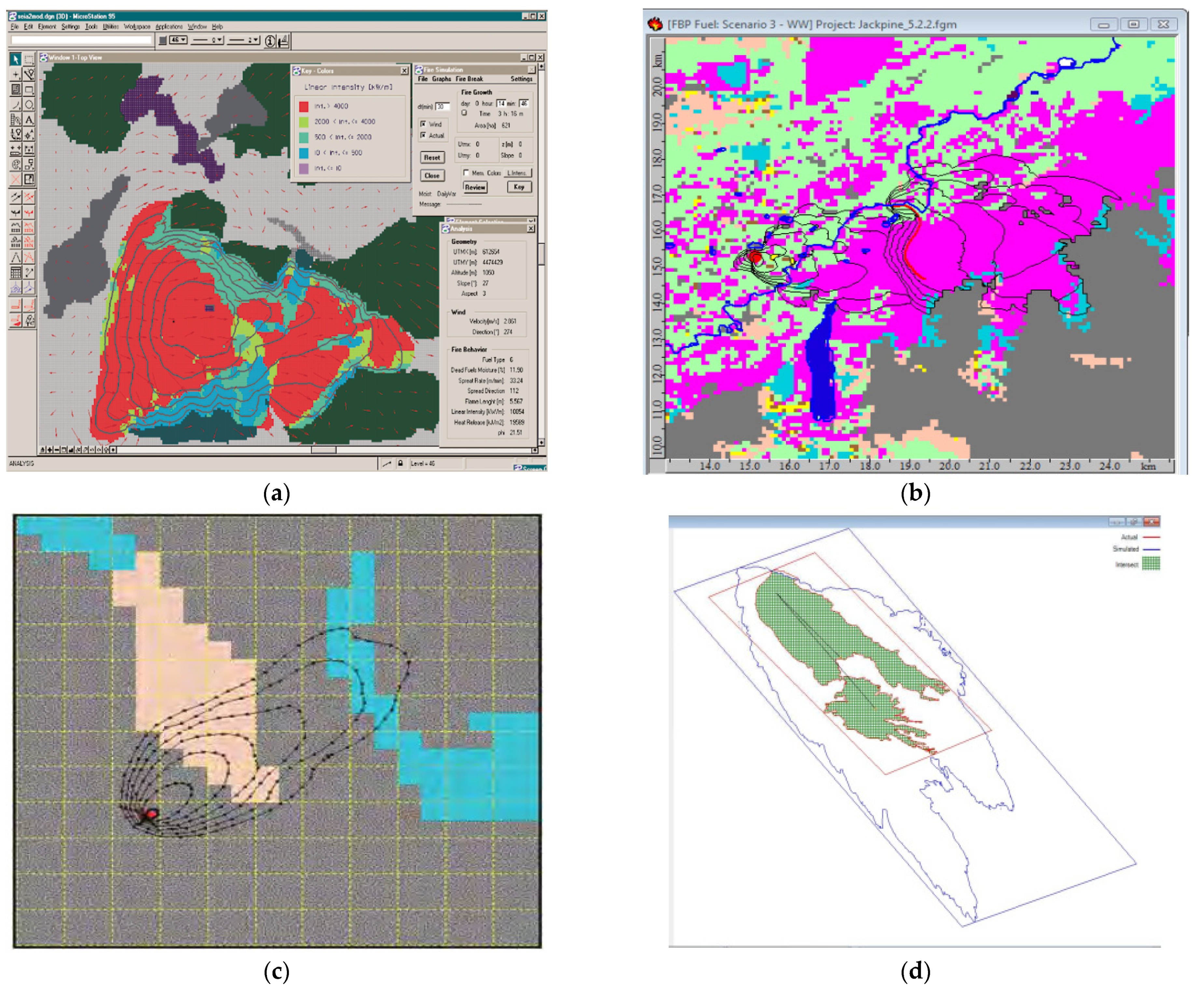
| FireStation | Raster-based | Rothermel model | FireStation is used in fire propagation modeling across complicated topographies. An important feature that is available in FireStation platform is combined with wind field simulations which are highly applicable in molding wildfire. | [60] |
| Geofogo | Raster-based | Rothermel model | Geofogo is a Windows-based dynamic GIS platform that has been developed in a fully integrated systems strategy using C++ programming mode. Geofogo needs a digital cartographic database that contains raster and vector maps of different compositions and covers all the terrain and other variables required for the estimates of rate of spread of fire (slope, aspect, and fuel). | [61] |
| FireMap | Raster-based | Rothermel model | FireMAP offers a receptive, inexpensive and safe capacity to examine the wildland fires intensity and severity. FireMAP is comprised of unmanned aerial systems and software to process and geo-analyze imagery. After a fire has been extinguished, the software then analyzes the imagery, recognizing the extent as well as the severity of the burn. | [62] |
| HFire | Raster-based | Rothermel model | Hfire is in the C programming language. Using HFire one can forecast the speed and direction of a fire propagating across the landscape in real-time. HFire can also be employed for stochastic multi-year modeling of fire regimes. | [63,64,65] |
| FlamMap | Raster-based | 1-Rothermel 2-Van Wagner’s crown fire initiation model 3- Nelson’s dead fuel moisture model | FlamMap is an incidence software and fire climatology mixing few computer-based programs (including CLIMATOLOGY, FIRES, pcSEASON, pcFIRDAT) into a uniform package. The FlamMap software can produce raster maps of potential fire behavior characteristics (e.g.,: spread rate, flame length, crown fire activity) and environmental conditions (solar irradiance, dead fuel moistures, and mid-flame wind speeds) over an entire study zone. | [66,67] |
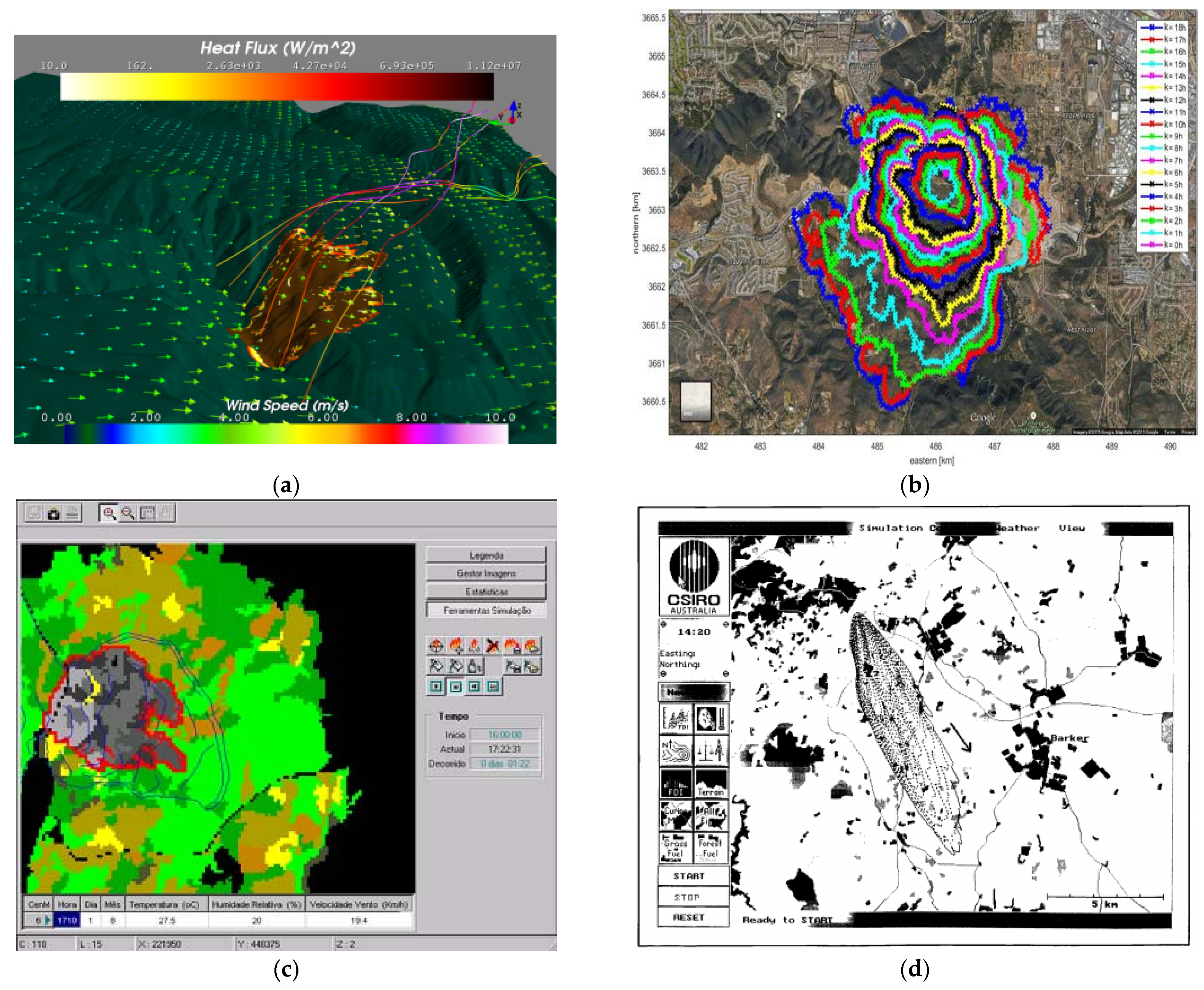
| Farsite | Huygens | Rothermel model | FARSITE is a 2D deterministic fire growth simulating platform. This software combines models for surface fire, spot fire, crown fire, and fuel/vegetation moisture. FARSITE generates maps of fire propagation and behavior in vector and raster schemes by using Huygens’ Principle. The fuel model map is the chief input for the FARSITE simulation software | [68,69,70,71,72,73,74,75,76,77,78,79,80] |
| SiroFire | Huygens | McArthur model | SiroFire is a DOS-protected-mode application. It runs in a Windows-like platform with a full graphical user interface environment. It employs GIS-derived geographic databases and digital elevation models and shows the outcomes of the fire propagation simulation as a graphical representation of the fire spread over the landscape Fire spread prediction in SiroFire is grounded on the finite difference method. | [81,82] |
| WRF-Fire | Raster-based | semi-physical Balbi | It combines the weather data and forecasting model with a fire code which applies a surface fire model and calculates the propagation rate of the fire line. An important motive for the development of the WRF-Fire software was the capability of WRF to export and import state, therefore enabling data assimilation (input of additional data while the model is running), which is necessary for fire behaviour forecast from all accessible data | [83,84] |
| FIRETEC | Physics-based computational fire model | ---- | It is a 3-dimensional two-phase transport model that resolves the conservation equations for mass, momentum, energy, and chemical species. FIRETEC is a coupled fire–atmosphere model; therefore, it genuinely contains the wind effect on the fire and the feedback effect from the fire to the wind. FIRETEC is based on a Large Eddy Simulation (LES) approach for turbulence, which attempts to resolve large turbulent fluctuations while modeling smaller fluctuations (i.e., smaller than the mesh size) using a set of turbulent kinetic energy equations | [85] |
| WFDS | Physics-based computational fire model | ---- | FDS solves numerically a form of the Navier–Stokes equations appropriate for low-speed, thermally driven flow with an emphasis on smoke and heat transport from fires. The WFDS model refers to various sub-models within the FDS framework that represent wildland fuels. Application of the WFDS model to full-scale wildfires is still in its early stages. WFDS computes the mass loss and burning behavior of vegetative fuels | [86] |
| FIRESTAR | Physics-based computational fire model | ---- | It Is based on an implicit solver and the combustion reaction rate was calculated using an Eddy Dissipation Model. It is dedicated to simulating wildfires at a relatively large scale. It is able to take into account the presence of various solid fuel particle types inside the same grid cell | [86] |
| Software | Import Parameters |
|---|---|
| SiroFire | Fire perimeter, humidity, weather, fuel properties, geographical information (it is introduced using a record structure including the number of vertices in the perimeter of the fire, a pointer to the vertices, and fire’s extents [89,90]. |
| Farsite | Different Standard/custom fuels, relative moisture, fire ignition, wind axis and velocity, temperature, and slope (commencing position of fire that can be a polygon, line, or point) [89,91] |
| FlamMap | jungle canopy base height, jungle canopy height, jungle canopy cover, fuel models, and topographic [89,92] |
| Hfire | Wind velocity, fuel humidity, and fuel properties such as thermal content, volume ratio, and fire load [93] |
| WRF-Fire | Geographical information, fire properties such as thermal flux, fire spread rate, fuel features, and fire model), fuel information, wind information, ignition data, and atmospheric information [89,94] |
| Geofogo | Topography (aspect Map and slope Map), weather, leaf area index map, and fuel model map [89] |
| Firestation | Custom/Standard fuel types, wind reading using metro stations, fuel humidity, relative moisture, temperature, and elevation [89] |
| Prometheus | Duration and type of estimation, content, fuel humidity, topography, weather, and fuels [89] |
| References | Materials Covered | Conclusion |
|---|---|---|
| Williams-Bell et al. [96] | The improvement of virtual model applications used for fire service. | The advantages of novel navigational instruments in recreating the decision-making procedures which firefighters should face in an emergency condition. |
| Perry [97] | Accessible simulating ways designed to estimate the spatial and spread behavior of wildland fire conditions. | The modeling of wildland fire is restricted by the challenges inherent in integrating geographic data mechanisms and environmental procedure simulations. |
| Parisien [98] | Categorize the application of termed burn probability simulations as follwos: 1. Direct examination 2. Neighborhood procedures 3. Fire risk and dangers 4. Integration with secondary simulations. | The flexible nature of termed burn probability simulating gives the user the chance to specify what their impact would be on wildfire hazard. |
| Thompson and Calkin [99] | Risk and uncertainty in wildland fire management. | A main problem is a more appropriate definition of non-market sources at risk, in two aspects: their behavior in fire conditions and how society evaluates those sources. |
| Imran [100] | Empirical analyses on fire for offshore buildings and its restrictions. | In most of the instances, empirical analyses cannot estimate all behavior of the fire and also structural sections. |
| Martell [101] | The utilization of operational study and management science techniques. | The improvement of new telecommunication and transportation mechanisms have helped the creation of international collaborative agreements making it possible for fire managers to fast mobilize greater forces compared to that was ever the instance in the past. |
| Tabibian et al. [102] | The fire ventilation techniques in fire measurement and safety techniques. | 1. It is significant to regard the fire placement in designing the smoke ventilation mechanism. 2. Also, they presented a CFD modeling of exhaust ventilation mechanism to control the smoke. |
| Thompson et al. [103] | Problems specifying and showing the performance of great fire management. | Great fire management is able to be qualitatively and considerably disparate from fast initial response operations, and also approximately all investigations which target performance gains have concentrated on initial responses. |
| Wegrzyn’ski et al. [104] | Fire and wind coupled simulations. | Lack of effective mesoscale simulations to consider real-period conditions for modeling within emergency response. |
| Huntera et al. [105] | Correlations between wildfire regimes and prescribed fire. | It expressed that analyses on the implications of wildfire regimes and prescribed fire with respect to other than carbon and emissions are small and this expresses a critical research requirement. |
| Mousavi et al. [106] | Post-earthquake fire risk to structures. | 1. There is a requirement for the improvement of guidelines for the design of structural fire safety. 2. Numerical modeling methods for the assessment of the structural efficiency under earthquake fire situations require to be improved. |
| Sullivan et al. [107] | Whole surface fire spread simulations improved from 1990 to 2018. | It is hard to evaluate all needed quantities to the degree of accuracy and precision needed by the accessible simulations. |
| Birajdar et al. [108] | Improvement un structural fire detection and evacuation mechanism. | Some fields require more development: 1. LoRa for great-range communication 2. Customized hardware for more reliability 3. Dynamic display guide 4. People density for safe evacuation is recommended. |
| Hu et al. [109] | Burning response of pool fire in wind conditions. | The flame soot and radiation emission which couple with complicated stream turbulence scales because of the interaction of buoyancy with wind need more research work. |
| Ronchi et al. [9] | Fire evacuation in high-rise structures. | 1. Future research works and simulation improvements should concentrate on the analysis of the effect of staff actions, people with disabilities, and group dynamics. 2. The impacts of fatigue on evacuation require extra analyses. |
| Johansson et al. [10] | Utilization of Fire Dynamic model in Fire Service Activities. | It was revealed that fire dynamic models are applied more in the investigative and preventive fields compared to the operational field of fire service activities. |
| Ghodrat et al. [110] | Fire-wind interaction | 1. The airstream behavior is of basic significance in specifying fire progression on the heat-releasing rate related to structures. 2. Applying wind-control systems is recommended to keep safe situations for firefighters. |
| Bakhshaii et al. [111] | Novel generation of wildfire-atmosphere simulating. | Current knowledge is not enough for advanced estimation and detection of great-risk fields, measurement of thermal output gratitude, or fire size. |
Disclaimer/Publisher’s Note: The statements, opinions and data contained in all publications are solely those of the individual author(s) and contributor(s) and not of MDPI and/or the editor(s). MDPI and/or the editor(s) disclaim responsibility for any injury to people or property resulting from any ideas, methods, instructions or products referred to in the content. |
© 2022 by the authors. Licensee MDPI, Basel, Switzerland. This article is an open access article distributed under the terms and conditions of the Creative Commons Attribution (CC BY) license (https://creativecommons.org/licenses/by/4.0/).
Share and Cite
Ghodrat, M.; Shakeriaski, F.; Fanaee, S.A.; Simeoni, A. Software-Based Simulations of Wildfire Spread and Wind-Fire Interaction. Fire 2023, 6, 12. https://doi.org/10.3390/fire6010012
Ghodrat M, Shakeriaski F, Fanaee SA, Simeoni A. Software-Based Simulations of Wildfire Spread and Wind-Fire Interaction. Fire. 2023; 6(1):12. https://doi.org/10.3390/fire6010012
Chicago/Turabian StyleGhodrat, Maryam, Farshad Shakeriaski, Sayyed Aboozar Fanaee, and Albert Simeoni. 2023. "Software-Based Simulations of Wildfire Spread and Wind-Fire Interaction" Fire 6, no. 1: 12. https://doi.org/10.3390/fire6010012
APA StyleGhodrat, M., Shakeriaski, F., Fanaee, S. A., & Simeoni, A. (2023). Software-Based Simulations of Wildfire Spread and Wind-Fire Interaction. Fire, 6(1), 12. https://doi.org/10.3390/fire6010012